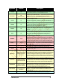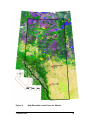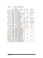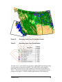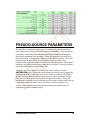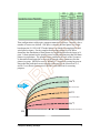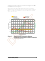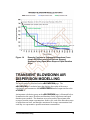
1
ERCBflare FT A Model for Temporary Flaring Permits, Non-Routine Flaring and Routine Flaring Air Dispersion Modelling for Sour Gas Facilities D R A User Guide, ERCBflare Version 2.00 ERCBflare FT A Model for Temporary Flaring Permits, Non-Routine Flaring and Routine Flaring Air Dispersion Modelling for Sour Gas Facilities A User Guide, ERCBflare Version 2.00 A Report Prepared for R Energy Resources Conservation Board (ERCB) D Funded in Part by Petroleum Technology Alliance of Canada (PTAC) Alberta Upstream Petroleum Research Fund (AUPRF) Energy Resources Conservation Board (ERCB) 8 May 2013 ERCBflare was developed for Energy Resources Conservation Board (ERCB) of Alberta, Canada by: Brian W. Zelt, Ph.D., P.Eng. Zelt Professional Services Inc. Please Reference this document as: FT Michael J. Zelensky, M.Sc., P.Eng. Energy Resources Conservation Board Energy Resources Conservation Board (ERCB). 2012. ERCBflare User Guide: A Model for Temporary Flaring Permits, Non-Routine Flaring and Routine Flaring Air Dispersion Modelling for Sour Gas Facilities, Version 2 Distributed by A 8 May 2013 D R Energy Resources Conservation Board Centennial Place Suite 1000, 250 – 5 Street SW Calgary, Alberta T2P 0R4 Telephone: 403-297-2625 Fax: 403-297-3520 Web site: http://www.ercb.ca/regulations-and-directives/directives/directive060 Liability Disclaimer These models, software and documentation were prepared by the ERCB (Energy Resources Conservation Board), to the specifications set by ERCB. ERCB warrants that the SOFTWARE will perform substantially in accordance with the provided documentation. ERCB, nor any person acting on their behalf, makes any warranty, guarantee, or representation, expressed or implied, that the software and related materials, without limitation, are free of errors, are consistent with any standard of merchantability or will meet user's requirements for a particular application, that any calculations performed by the software are correct or accurate, that the software is compatible with particular computer systems, computer peripherals and other software packages, or that the software will run uninterrupted. FT EXCEPT AS PROVIDED ABOVE, THIS DOCUMENTATION AND SOFTWARE IS LICENSED "AS IS" WITHOUT WARRANTY AS TO ITS PERFORMANCE. NO OTHER WARRANTIES APPLY. ERCB DISCLAIMS ALL OTHER WARRANTIES, EITHER EXPRESS OR IMPLIED, INCLUDING BUT NOT LIMITED TO IMPLIED WARRANTIES OF MERCHANTABILITY AND FITNESS FOR A PARTICULAR PURPOSE. THIS LIMITED WARRANTY GIVES YOU SPECIFIC LEGAL RIGHTS. YOU MAY HAVE OTHERS, WHICH VARY FROM PROVINCE TO PROVINCE. D R A IN NO EVENT SHALL ERCB, OR THEIR SUPPLIERS BE LIABLE FOR ANY DAMAGES WHATSOEVER INCLUDING, WITHOUT LIMITATION, DAMAGES FOR LOSS OF BUSINESS PROFITS, BUSINESS INTERRUPTION, LOSS OF BUSINESS INFORMATION, CONSEQUENTIAL DAMAGES, OR OTHER PECUNIARY LOSS, HOWSOEVER ARISING OUT OF THE USE, ATTEMPTED USE OF OR INABILITY TO USE THIS PRODUCT, EVEN IF ERCB HAS BEEN ADVISED OF THE POSSIBILITY OF SUCH DAMAGES. Minimum System Requirements for ERCBflare ERCBflare is a Windows® based software application requiring Microsoft® Excel as a user interface. The minimum system requirements* are: • • FT • • • • • • Windows®8; Windows®7; Vista; Windows XP Microsoft® Excel. (Program testing completed on Office 2007, 2010 and 2013) x64 or x86 1024x768 minimum resolution recommended 2 GHz processor minimum recommended 4 GB RAM minimum recommended Windows® - compatible mouse Optional: colour or b/w printer (300 dpi or better recommended) D R A ** Users may require administrative rights in order to run the install package. TABLE OF CONTENTS 1. Introduction .......................................................... 1 Model Changes ............................................................................................................. 2 Version 1.x to 2.00 2 User Qualifications ....................................................................................................... 6 Suitable Technical Background 6 How this Document is Organized ............................................................................... 7 About this Guide ........................................................................................................... 8 Where to Go for Help .................................................................................................... 8 What is ERCBflare all about? ...................................................................................... 8 INSTALLATION AND SETUP................................. 11 FT 2. Overview of the Installation Process ........................................................................ 11 SETUP .......................................................................................................................... 13 3. ERCBflare INPUTS .............................................. 17 Introduction ................................................................................................................. 17 Graphical User-Interface ............................................................................................ 18 Overview – The ERCBflare GUI in Excel 18 Stand-Alone Central Database 18 19 A The ERCBflare Excel Pages 20 iSTART ......................................................................................................................... 22 Fundamentals 22 Permit or Evaluation Mode Flaring Classification Hide Technical Pages Hide iBATCH Page Hide iBIN page 22 23 25 25 25 R Advanced Switches D MRUNBAT MPAUSE MKEEP MKEEPOUT MRELLOC MEXPREC MSCREEN MELEV MDEMGET MLCCGET 25 26 26 26 27 27 27 27 28 28 28 Non-Default Settings Ambient Temperature Average Ambient Wind Speed PG Stability Class Qmin Fraction of Qmax SO2 1h Air Quality Objective H2S 1h Air Quality Objective Receptor Resolution for Maximum Concentration Raw, Fuel and Lift Gas Temperature Before Combustion Run Flags User Period Selection (Annual or Month) Transient Blowdown distribution of mass option Blowdown User Entry of Qmax Blowdown User Entry of Qtotal Land Use around the Well 28 29 30 30 30 31 31 31 31 32 33 33 33 33 34 iFACILITY ..................................................................................................................... 34 Administrative-Operator Administrative-Consultant TABLE OF CONTENTS 34 35 i Well or Facility Details 35 35 35 35 36 36 37 37 37 37 38 38 39 39 43 43 44 44 44 44 44 FT Well Name Licence Number Unique Well Identifier (UWI) Oil or Gas Critical Well Classification Formation(s) and Zone(s) to be Tested Number of Zones to be Tested Lahee Classification Surface Location Mapping Projection Surface Coordinates of Flare Flare Base Elevation Land-use Characterization Operations to be Conducted Total Volume of Raw Gas to be Flared Total Estimated Days with Flaring for ALL Zones Well tied into Production Facilities Information on the Feasibility of In-Line Well Testing Attached Previous Flaring/Incineration Permit Requested Approval Start Date/End Date Emergency Response Details H2S Release Rate Emergency Response Planning Zone Distance Is an ERP Required? ERP Reference Number Fluid Production Details Anticipated Fluid Production Gas to Fluid Ratio 45 45 45 45 46 46 46 46 iFLARING ..................................................................................................................... 47 Flaring Details 47 A Subject Zone/Source Scenario Name Time of Year to Model the Flare Flare Stack Tip Exit Height Flare Stack Tip Exit Diameter Requested Maximum Raw Gas H2S Concentration 48 48 48 49 49 49 Continuous/Steady or Transient Continuous or Short-Term Steady R Maximum Raw Gas Flow Rate Average Flow Rate Parameters 49 50 50 50 Transient Source Fuel Gas Lift Gas Flare Assist D Steam Assist Air Assist Flare Assist Flammability Check 51 51 52 52 53 54 54 Gas Compositions Gas Composition Total Gas Analysis Reference 54 55 56 iTERRAIN ..................................................................................................................... 56 Topographical Map Details and Maximum Terrain 56 1:50,000 Topographical Map(s) 57 Contour Interval Units of Map 57 Contour Interval of Map With Maximum Elevation 57 Is Maximum Elevation A Surveyed Peak? 57 Maximum Contour Elevation or Surveyed Peak Elevation 58 Map Distance from Flare to Centre of Maximum Contour or Maximum Surveyed Peak Elevation 58 Worst Case Terrain and Complex Terrain Criteria Parameters Complex Terrain Summary 58 60 Get DEM Data – BUTTON 60 Load XYZ DEM Data – BUTTON 61 iNOTES......................................................................................................................... 61 TABLE OF CONTENTS ii 4. AIR DISPERSION MODELLING AND OUTPUT ......... 63 cmax xmax ws PG xobj1 xobj2 xobj3 Concentration CLIMIT Concentration RBC FT PSEUDO-SOURCE PARAMETERS ............................................................................ 64 CALCULATION BUTTONS ......................................................................................... 67 1.AERSCREEN-MAX 70 2.AERSCREEN-(RBC) (User Met) 70 3.AERMOD-RBC (User Terrain & User Met) 71 4.Create AERMOD files (Average Wind Speed) 71 5.AERSCREEN-MAX (HbH) 71 6.AERSCREEN-RBC (User Met) 71 7.AERMOD-RBC (HbH User Terrain & User Met) 72 8.Create AERMOD files (HbH User Met) 72 Example Run-Times 72 NON-ROUTINE FLARE AIR DISPERSION MODELLING .......................................... 73 ROUTINE FLARE AIR DISPERSION MODELLING ................................................... 74 AERSCREEN INPUTS ................................................................................................. 75 Hour by Hour 76 AIR DISPERSION MODELLING PREDICTIONS ........................................................ 78 oAERSCREEN Output Summary 78 79 79 79 79 80 80 80 80 80 R A oMODELLING Output Summary 81 ONE-HOUR AVERAGES FROM SUB-HOURLY EMISSIONS ................................... 81 ERCB D060 Permit Conditions .................................................................................. 82 OUTPUT SUMMARY OF SOURCE ............................................................................. 84 OUTPUT SUMMARY OF AIR DISPERSION MODELLING ........................................ 86 OUTPUT FIGURE 1 ..................................................................................................... 86 OUTPUT FIGURE 2 ..................................................................................................... 88 5. TRANSIENT BLOWDOWN FLARING ...................... 90 TRANSIENT BLOWDOWN INPUTS ........................................................................... 90 Transient Source 91 D Expected Maximum Initial Pressure, PRESS0 92 Expected Minimum Initial Gas Temperature, TEMP0 92 Expected Minimum Final Pressure, PRESS1 92 Pipeline/Vessel Inside Diameter, VESSELDIA 93 Pipeline/Vessel Length, VESSELLEN 93 Minimum Orifice Diameter, ORIFICE_DIA 93 Discharge Coefficient, DCOEFF 93 Select the way the blowdown curve is converted from a continuous curve to discrete steps, MDIST 94 Raw Gas User Initial maximum flow rate, QMAX 94 Raw Gas User Total volume within vessels/pipes, QTOTAL 95 User selected # of puffs, NPUFFS 95 User selected puff duration, PUFDUR 95 TRANSIENT BLOWDOWN AIR DISPERSION MODELLING .................................... 96 TRANSIENT BLOWDOWN OUTPUT .......................................................................... 97 6. ADVANCED TECHNIQUES ................................... 98 SITE SPECIFIC METEOROLOGY ............................................................................... 98 Step 1 99 Step 2 100 Step 3 101 TABLE OF CONTENTS iii Step 4 (Optional) 101 SITE SPECIFIC TERRAIN ......................................................................................... 102 Step 1 102 Step 2 103 REFINED MODELLING ............................................................................................. 104 Non-Routine Flare Air Dispersion Modelling 104 Routine Flare Air Dispersion Modelling 105 POST-PROCESSING EXTERNAL REFINED MODELLING OUTPUT ..................... 106 7. BATCH OPERATIONS ....................................... 107 Batch File Step-by-Step ........................................................................................... 107 iBATCH PAGE AS A DATABASE ............................................................................ 108 EXAMPLE iBATCH SENSITIVITY SETUP................................................................ 109 References ...................................................... 112 FT 8. Appendix A .............................................................. 114 A FUNCTION calcmaxcr(…)......................................................................................... 114 FUNCTION wsstkht(…) ............................................................................................. 118 FUNCTION fneq90(…)............................................................................................... 119 FUNCTION fneq91(…)............................................................................................... 120 FUNCTION NR_Texhaust(…) ................................................................................... 121 Function NR_XL(…) .................................................................................................. 122 FUNCTION p_sat(…) ................................................................................................. 123 FUNCTION t_sat(…) .................................................................................................. 124 FUNCTION FNz(…).................................................................................................... 125 Credits........................................................................................................................ 127 Mapping Code 127 Nearest Neighbour Code 127 R LIST OF TABLES Land Cover Classification .................................................................... 41 Screening Land Cover Classification ................................................... 42 Screening Meteorological Variations Used for AERSCREENMAKEMET.exe .................................................................................... 43 Representative Pipeline Quality Natural Gas (Hubbard 2009) ............ 55 D Table 1: Table 2: Table 3: Table 5: LIST OF FIGURES Figure 1: Figure 2: Figure 3: Figure 4: Figure 5: Figure 6: TABLE OF CONTENTS ERCBflare Page Name and Typical Linkage....................................... 19 High Resolution Land Cover for Alberta .............................................. 40 Screening Land Cover for Western Canada........................................ 42 Worst Case Complex Terrain Graphic Showing Terrain Elevations as a Function of Distance from the Source Versus Stable Atmosphere Plume Rise........................................................................................... 59 SO2 Flare Model for Source Parameters ............................................. 65 H2S Stripping Model for Source Parameters ....................................... 66 iv Figure 7: Figure 8: Calculation Flowchart .......................................................................... 68 Illustration of the Range of Plume Rise (centrelines) for An Hour By Hour Source Model .............................................................................. 78 Example oFIGURE 1 showing the Maximum Concentration at the Receptor Location in Comparison to the Terrain Elevation ................. 87 Example oFIGURE 1 showing the Wind Speed that Causes the Maximum Concentration at the Receptor Location ............................. 88 Example Emissions Chart from oFIGURE 2 for Hour-By-Hour Assessment ......................................................................................... 89 Example Efficiency Chart from oFIGURE 2 for Hour-By-Hour Assessment ......................................................................................... 89 Coefficent of Discharge for Gas Flow Through an Orifice (Mannan 2005) .................................................................................................... 94 Example Continuous Exponential Blowdown Curve shown ERCBflare modelled Discrete Stepped Sequence using Equal Mass Steps or Equal Duration Steps ........................................................................... 96 Figure 9: Figure 10: Figure 11: Figure 12: Figure 13: D R A FT Figure 14: TABLE OF CONTENTS v 1. Introduction FT ERCBflare, A Model for Temporary Flaring Permits, Non-Routine Flaring and Routine Flaring Air Dispersion Modelling for Sour Gas Facilities The Energy Resources Conservation Board (ERCB) of Alberta has developed ERCBflare for evaluating non-routine and routine flaring for Sour Gas Facilities. This User Guide is for the ERCBflare modelling spreadsheet and associated modules. The User Guide outlines how to install, use the model and provides examples on the use of the model. A The ERCBflare model was designed to perform state of the art source estimates for flares and perform screening level air dispersion modelling using state of the art techniques using existing dispersion models. The user must have a good understanding of the following documents: R 1. ERCB Directive 060 (requirements for temporary flaring permits, nonroutine and routine flaring air dispersion modelling expectations, ERCB 2013), 2. ESRD Air Quality Modelling Guideline (2013), ESRD Non-Routine Flaring Management: Modelling Guidance (2013), D 3. AERSCREEN and AERMOD (U.S. EPA 2011) The ERCBflare model documentation is comprised of three components that are described in the following table. 1 Introduction 1 Description ERCBflare.xlsm a Microsoft®-Excel (Office 2013) application software for Windows® containing macros and a user interface to external calculation modules Screening Meteorological Data Files A set of sixteen data files created using the AERSCREEN modelling system component MAKEMET for the eight basic land use groups described in the AERMOD user guide. For each land use type, there is a surface and a profile meteorological file. Each file is an AERMOD-ready meteorology file containing a full range of meteorological conditions using three month seasons and the range of conditions found in Alberta. User Guide Version 1.00.pdf this User Guide FT Module All of these documents and programs are available as a single download from the on the ERCB website. For the latest updates visit the ERCB website: http://www.ercb.ca/regulations-and-directives/directives/directive060 A Also required is the AERMOD air dispersion model. The AERMOD source code, documentation and executable files are available at the U.S. EPA Technology Transfer Network website: R http://www.epa.gov/ttn/scram/dispersion_prefrec.htm#aermod D Model Changes Version 1.x to 2.00 • Added annual and monthly air dispersion modelling predictions. The monthly predictions are based upon the month of the proposed flaring plus the month before and after. Using a 5-year data set, this allows for N>8760 and thus the Risk Based Criteria can be applied. • Added inefficiency by-products stream for air dispersion modelling impacts of products of inefficiency. These products are modelled as raw H2S whereas combustion products are modelled SO2. The H2S source differs from the SO2 source; the H2S has a lower heat component based 1 Introduction 2 upon convective stripping of energy from the flame and momentum is calculated from the mass flow not combusted. Added lift gas stream effects to combustion calculations. • Added flare assist streams for air and/or steam flaring assist. The flare assist streams impact the combustion calculations by adding momentum, energy and reducing the combustion efficiency of the flare. • Added conversion of sub-hourly emissions predicted concentrations to hourly average concentration. • Added transient blowdown calculations. The spreadsheet prompts for volume, pressure and temperature of vessel to blowdown and calculates the exponential blowdown curve for the inputs. The curve is divided into three steps for modelling. The modelling predictions determine the maximum hourly concentration from the curve based upon the duration of each step and the maximum predicted concentrations for each step. • Added oFIGURE 1 page to display in a graphical format the predictions as a function of distance from the facility. The graphic shows max concentration, wind speed producing the maximum concentration, PG atmospheric stability leading to maximum concentration as a function of distance. • Added oFIGURE 2 page to display in a graphical format the statistical summary of emissions and combustion efficiency for hour-by-hour flaring analysis R A FT • Added a DEFINITIONS reference page as per D060 • Added a LAHEE reference page. Linked the Lahee reference page to the flaring inputs for the determination of the maximum flaring volume allowance as per D060. D • • Changed the summary page to reflect the numerous changes below. Also added a check-list style table at the top of the page to summarize how the inputs compare to D060 requirements for approvals. • Changed the ATTACHMENTS page to iNOTES page. iNOTES page has specific prompts for questions that ERCB approval reviewers may consider in the review of the application. • Added a iBATCH and oBATCH pages for batch operation of spreadsheet. Users can save the input page to the batch page. Inputs and outputs are saved. 1 Introduction 3 Added NON-DEFAULT flag for all output pages when a non-default setting is selected. • Added start-page for the selection of type of assessment, advanced program operations and non-default settings • Non-routine flaring uses the hour-by-hour variation in source parameters. This is implemented in AERMOD using a time varying emissions file and a co-located source. Three sources are defined based upon an estimate of the final rise of the hourly variation. • Routine flaring uses the average meteorological wind speed and temperature. • Added the prediction of concentrations based upon the non-routine flaring Risk Based Criteria. • Added distinction between non-routine flaring and routine flaring. Both are modelled at 3-emission rates. Non-routine flaring results are compared to risk based criteria and routine flaring results are compared to ESRD established modelling objectives. • Added AERSCREEN/AERMOD air dispersion modelling. Associated with this change are the following additions: A FT • R o added 8-screening meteorological data sets corresponding to the 8land use types in the Alberta Air Quality Modelling Guideline. The meteorological data sets represent 100% land cover for the respective land cover type D o added a mapping of Alberta, British Columbia and Saskatchewan for land cover reduced to the 8-land use types. The spreadsheet prompts for a location and the nearest land cover cell value is used to represent the air dispersion modelling. o allowance for coordinates in geographical coordinates, UTM zones 8,9,10,11,12,13 and 10TM o air dispersion modelling is performed for the parallel air-flow and elevated terrain from 100m to 10km. The spreadsheet prompts for terrain elevations from the base elevation to the maximum terrain elevation. o Screening assessment using the AERSCREEN approach with the 8screening meteorological data sets is intended for rapid assessment. 1 Introduction 4 Added AERMOD air dispersion modelling for refined analysis. Following a step-wise progression from screening to refined analysis, ERCBflare can create a refined dispersion modelling input files for AERMOD, run AERMOD, and post-process the results for non-routine, routine and blowdown sources. • Removed SCREEN3; removed the 99% percentile concentration prediction based upon ISCST3 air dispersion modelling; fuel gas log; and minimum fuel calculation based upon the 99% concentration. • Added digital terrain processing for inputs to the iTERRAIN page. Digital elevation data (DEM) is downloaded from the internet site automatically or pulled from a user’s local library. The terrain processing extracts worst case terrain contour elevations as would be done if performed manually; therefore, manual entry of worst case terrain remains an applicable option. • Added iUSERMET page to develop a site specific meteorological data set suitable for refined dispersion modelling using AERMOD. The meteorological data set is composed of data from the ESRD MMEU Meteorological Processor extraction of MM5 data for the province of Alberta. The iUSERMET page processing also downloads land use classification code (LCC) files for Canada from the internet or the user’s local library. The LCC files are processed using AERSURFACE methodology to determine an average Bowen Ratio, albedo and surface roughness for the user’s assessment site. The AERMET processor is subsequently used to create a site specific meteorological file. R A FT • Added iUSERTER page to develop a site specific receptor grid suitable for refined dispersion modelling using AERMOD. Digital elevation data (DEM) is downloaded from the internet site automatically or pulled from a user’s local library. The user can create an ESRD standard assessment grid or modify the receptor spacing. Terrain and hill scale factors are determined from the DEM data and output to an AERMOD formatted insert file. D • • Added oPOSTPROCESS page to post process external AERMOD output for the determination of ERCB D060 risk based criteria. Similar to the post-processing provided by the ERCBflare spreadsheet automated assessment, the oPOSTPROCESS page allows a user to process output created external to the ERCBflare interface. The oPOSTPROCESS page allows for advanced statistics for graphical presentation or in-depth analysis. 1 Introduction 5 User Qualifications FT ERCBflare is freely distributed to assist in D060 temporary flaring permitting, non-routine and routine flaring air dispersion modelling within Alberta. ERCBflare performs both screening level calculations (uses only a few user inputs to create a realistic and conservative estimate of flare emissions and concentrations) and also refined level calculations. Although relatively few inputs are required through the interface, it is a complex tool. ERCBflare requires inputs that may require sound engineering judgement or other technical expertise. It uses site-specific thermodynamics, fluid dynamics, and air dispersion modelling. Flare dispersion assessment is a multidisciplinary and iterative task with many assumptions and judgments. A The ERCBflare model was created so that a minimal amount of technical background is required to run the models. However, there remains some technical knowledge required to supply suitable inputs and the ability to understand whether the output is appropriate for the inputs and meets the needs of stakeholders. The user must recognise that the models are technical in nature and the correct interpretation of the result may require technical expertise that proceeds from consequences of the inputs. In any modelling assessment, high quality input data is very important. R The model has been created with a professional commitment to environmental protection and safeguarding the well-being of the public. It is the responsibility of the software user to accept and continue this commitment in their application of the software. The software is supplied as a tool to assist the user to comply with applicable statutes, regulations and bylaws. Neither the software nor application of the software is intended to replace statutes, regulations or bylaws. D Suitable Technical Background Environmental issues are interdisciplinary in nature. The practice of environmental science requires the integration of diverse disciplines and philosophies; many projects will require a team of appropriate specialists to address complex environmental issues. Persons doing the assessment should undertake only that aspect of environmental work that they are competent to perform by virtue of training and experience. Thus they should seek out and use appropriate Environmental Specialists to provide expert advice on certain environmental issues. The basis of the models is technical with expertise required in chemistry, thermodynamics, atmospheric physics, meteorological processes, industrial processes and regulatory affairs. While the full technical background is not a 1 Introduction 6 requirement to execute the models, the user of the software is required to have a general engineering and environmental science background; a general knowledge of the emission sources: wells, pipelines, and pipeline networks; and a working knowledge of the most current version of: • • • ERCB Directive 060 – Alberta ESRD Air Quality Modelling Guideline and Non-Routine Flaring Management: Modelling Guidance. AERMOD/AERMET/AERSCREEN/AERSURFACE user guides FT There are many technical inputs required by ERCBflare to perform the calculations. Some have been prescribed by the ERCB as mandatory default entries. Others are input by the user for the specific flaring scenario. Use of ERCBflare and understanding whether the predictions are appropriate for the user inputs still, however, requires some specific technical understanding. A How this Document is Organized Capter Description 1 Introduction Backgrounder for ERCBflare 2 Installation and Setup How to install the ERCBflare program 3 ERCBflare Inputs Description of the program prompts and user entries 4 Air Dispersion Modelling and Output Description of the program output calculations and graphics 5 Transient Blowdown Flaring Description of inputs and modelling for flaring from the depressurization of vessels and pipelines 6 Advanced Techniques A description of the modelling that can be performed using ERCBflare going beyond screening air dispersion modelling 7 ERCBflare Batch Operation Description of the operation of ERCBflare for multiscenario operation D R This User Guide is organized as both an instructional guide and a tutorial. This guide is divided into the following chapters: 1 Introduction 7 About this Guide The following symbols and conventions are used in this guide Used for menu, command, and keyboard selections you Bold make and screens you will see. Italics Used for emphasis and to identify new terms text User typed responses or entries FT Helpful information about a particular topic. Important information to prevent problems and ensure that you are successful in using the software. A hyperlink to a section within the User Guide, an internet web site or email address A link R Where to Go for Help D ERCB welcomes your feedback. Comments on the current version, suggestions for features in future versions, or bug reports in the User Guide or ERCBflare software can be submitted to the email below. Please provide information on the version of Windows you are using, version of Excel, and enough information to duplicate the issue. Thank you. [email protected] What is ERCBflare all about? The ERCBflare spreadsheet tool was created to provide consistency in the calculation of flare-type source parameters for use with standard air quality dispersion models that are based upon chimney-type sources parameters. The basic premise of ERCBflare is to determine the energy released during a flaring event; this energy is released to the atmosphere giving buoyancy and momentum 1 Introduction 8 plume rise for the flare-type source. ERCBflare then uses the buoyancy and momentum energy and back-calculates chimney-type equivalent source parameters that can be used as inputs in typical air dispersion models. These parameters being the height, diameter, velocity and temperature of the source. The equivalent source parameters are frequently called pseudo-parameters. The parameters are called pseudo-parameters because they are not real-world dimensions, but only calculated inputs that represent the flare-type source so that the correct plume height is used in the standard dispersion model. Standard dispersion models determine the energy available for plume rise based upon the calculation of buoyancy and momentum energy from the entered chimney source parameters (height, diameter, velocity and temperature.) A FT Flaring can be loosely divided into three types: continuous, short-term steady and transient. Continuous flaring is flaring when the emissions occur hour after hour for long periods of time (weeks, months or years). The flared gas for continuous emissions can vary from zero flow rates, to low flow rates and to high flow rates over the course the flare duration. Short-term steady flaring is similar to continuous flaring but flaring occurs only for prescribed period of time. Transient flaring is similar to short-term steady flaring where the flare is operated for a prescribed period of time, but the flow rate to the flare originates from a high pressure blow down resulting in a scientifically well-defined change in flow rates from very high to low over a specific period of time. In each of the flare types, it is important to examine the range of low flow rates to high flow rates and the pollutants released during these periods. Low flow rates are associated with low plume rise and high flow rates are associated with higher plume rise. D R From a regulatory standpoint, flaring is divided into two broad categories: continuous (including short-term steady) flaring for routine operations; and, nonroutine flaring (including short-term steady and transient flaring). Non-routine flaring has special regulations because it is associated with specific disposal of large amounts of gas and typically high pollutant emissions. Non-routine flaring is divided into two categories: planned flaring (including well test flaring, maintenance and turn-around operations); and, unplanned flaring (including emergency flaring). The distinction between routine, non-routine (planned) and non-routine (unplanned) is the frequency of the flaring events and the inherent risk to environmental harm (consequence). Planned non-routine flaring from temporary flares requires a permit from the ERCB. ERCBflare version 1.x was originally created to specifically address the concerns related to the applications to ERCB for non-routine flaring associated with well test flaring. Because non-routine flaring events are often associated high energy and high levels of pollutant emissions, it was necessary to update the ERCBflare calculation tool to incorporate the more complex source conditions demanded by industry users, operations and high impact but low risk predictions. ERCBflare version 2.x was created to specifically address these complex questions and therefore ERCBflare is inherently more complex than its predecessors (ERCBflare version 1.x and ESRD flare tool). An important change also included in the 1 Introduction 9 ERCBflare 2.x is the updated air quality dispersion model used to predict environmental harm (AERMOD), and it too is more complex than its relatively simplistic predecessor (SCREEN3). D R A FT The purpose of ERCBflare version 2.x is to provide a relatively easy-to-use user interface tool to assist the user in the complex analysis of routine and non-routine flaring. The goal of ERCBflare is to predict a rapid (within minutes), conservative estimate of flaring impacts. It also provides next-step analyses methods to bridge the gap between rapid screening analysis and full-refined air quality dispersion modelling. 1 Introduction 10 2. INSTALLATION AND SETUP FT This chapter describes how to install the ERCBflare software. The ERCBflare modelling package includes a user interface (a Microsoft®-Excel Office 2013 spreadsheet) that prompts the user for inputs and controls operation of the air dispersion modelling stand-alone programs (specifically AERMOD). Microsoft Excel must be installed on your computer in order to use the ERCBflare tool. A Overview of the Installation Process R If you have not already done so, download the installation software from the ERCB website (see above). D The single install program setup.exe file contains all of the software required for the ERCBflare program to run within the users existing Microsoft Office (including Excel) environment. STEP 1: The ERCBflare tool is packaged as a downloadable ZIP file which the user can unpack to form a folder tree and access directly. Download the file ERCBflare package from: http://www.ercb.ca/regulations-and-directives/directives/directive060 There are three ZIP files provided File Intent Recommended Download Destination Folder ERCBflare_vxxxxxx.zip Required c:\myfiles\ercbmodels\ercbflare\ ERCBflare_UserGuide_vxxxxxx.pdf Required c:\myfiles\ercbmodels\ercbflare\docs\ 2 Installation & Setup 11 MAKEMET.zip Optional c:\myfiles\ercbmodels\ercbflare\makemet\ The ERCBflare_vxxxxx.zip file contains the necessary user-interface and meteorological data files used in the assessment flaring. It is recommended that the users download and read the user guide for ERCBflare. FT The MAKEMET.zip file contains a modified version of the U.S. EPA MAKEMET program. The U.S. EPA version of MAKEMET is command line driven, requiring the user to enter data and several prompts. The modified version of MAKEMET uses input files, and therefore is more readily useable for batch operations, and is less entry-error prone. MAKEMET is an optional processing that is required only if the user wishes to create a site-specific screening meteorological data file. The files may be installed to alternate folder locations during the installation. A STEP 2: User’s will also require files that are updated and distributed by the U.S. EPA: AERMOD and AERMET. The AERMOD source code, documentation and executable files are available at the U.S. EPA Technology Transfer Network website: http://www.epa.gov/ttn/scram/dispersion_prefrec.htm#aermod R The AERMET source code, documentation and executable files are available at the U.S. EPA Technology Transfer Network website: D http://www.epa.gov/ttn/scram/metobsdata_procaccprogs.htm#aermet The files may be installed to alternate folder locations during the installation. STEP 3: Using the Windows explorer (Windows Key + e) locate the ERCBflare_vxxxx.zip file that you downloaded STEP 1. Right clip on the file and select ‘unzip to here’ (if you have the WINZIP utility) or ‘unpack’ (if you are using the embedded unzip functionality within Windows). The following folders and files will be created (where [mydir] is the folder used in STEP 1: 2 Installation & Setup 12 [mydir]ERCBflare_vxxxxx.xlsm [mydir]metfiles\(conif.x;cult.x; decid.x;desert.x;grass.x,swamp.x; urban.x;water.x) FT [mydir]metfiles\test_ercbflare\(aermod.x) The ERCBflare spreadsheet tool The screening meteorological data files created using MAKEMET. These 8meteorological files are used to determine screening level concentrations using ERCBflare in the screening modes. For each meteorological file name there is a *.SFC and *.PFL file representing an AERMOD ready surface profile meteorology file, respectively. This folder contains an example site specific meteorological file. There is a *.SFC and *.PFL file representing an AERMOD ready surface profile meteorology file, respectively The test_ercbflare example site specific meteorological data file is provided as an example for use in the tutorials provided in this User Guide. User’s should not use the example site specific meteorological data for their air quality evaluations or permit applications. A STEP 4: If you haven’t already done so, download and install the AERMOD air dispersion model and AERMET meteorological model from the U.S. EPA website, previously listed. D R AERMOD must be installed on your machine in order to use all of the features of ERCBflare for air dispersion modelling screening. SETUP Now that you are finished installing the ERCBflare spreadsheet tool, meteorological files and AERMOD program, you can complete the installation by loading the ERCBflare spreadsheet and following the steps below. 1. From the select Windows START->Excel, this will launch Excel. Then using the Excel menu option File->Open or use the Windows Explorer to navigate to the installation folder for ERCBflare and [mydir] and double- 2 Installation & Setup 13 click on the ERCBflare_vxxxxx.xlsm file. This will load the ERCBflare tool into Excel. The ERCBflare spreadsheet is an XLSM file that contains typical spreadsheet-like calculations as well as program macros. This is the “M” part of the filename extension. When the file is opened, your computer and office security settings may display a warning. Select ‘Trust this document’ or ‘Enable Macros for this document’ if prompted when the file is opened. Failing to do so will prevent ERCBflare from operating. 3. Click on the iSTART page. Select “Show” for the Hide iBIN Page option. 4. Click on the iBIN page. For the entry for AERMOD, type the full path and file name of the AERMOD.exe file (previously installed). The Browse button can be used to navigate your file folder tree using common Windows Explorer methods. 5. For the entry for METFILES, type the full path and file name of the folder location where the screening meteorological files were stored. By default this will be: FT 2. A [mydir]\metfiles The files can be placed anywhere on your network. ERCBflare requires read access to the files only. If the BROWSE button was used to select the files or the SAVE button pressed, then ERCBflare stores the entry for your computer setup. If you load an uninitialized ERCBflare spreadsheet or a spreadsheet initialized to another users folder locations, ERCBflare synchronizes the settings to your computer setup. You have the option of saving the file when you have completed the calculations. You can force ERCBflare to synchronize by pressing the SYNC button. D R 6. 7. Click on the iSTART page. Select “Hide” for the Hide iBIN Page option. Typically, you shouldn’t have to revisit the iBIN page. However, use the iSTART page to show the iBIN page to make any changes to your system as required. Select ‘Trust this document’ or ‘Enable Macros for this document’ if prompted when the file is opened. Failing to do so will prevent ERCBflare from operating. ERCBflare spreadsheets must be saved as an XLSM file type to preserve the macro (Visual Basic for Applications) functionality. 2 Installation & Setup 14 This completes the mandatory components initialization of the ERCBflare. The user may wish to also initialize several optional components of ERCBflare. AERMET: On the iSTART page, for the row entry for AERMET, enter the full path for the location of the AERMET.exe file or use the BROWSE button to navigate to the installation folder and click on the AERMET.exe. FT MAKEMET: On the iSTART page, for the row entry for MAKEMET, enter the full path for the location of the MAKEMET.exe file or use the BROWSE button to navigate to the installation folder and click on the MAKEMET.exe. DEMLIB: On the iSTART page, for the row entry for DEMLIB, enter the full path for the location of where digital elevation files should be stored when downloaded from the internet. DEMLIB represents a library or cache to save time on subsequent analyses to avoid download times. Also, the DEMLIB provides a library of files for repeatability of ERCBflare predictions. A LCCLIB: On the iSTART page, for the row entry for LCCLIB, enter the full path for the location of where land-use classification code (LCC) files should be stored when downloaded from the internet. LCCLIB represents a library or cache to save time on subsequent analyses to avoid download times. Also, the LCCLIB provides a library of files for repeatability of ERCBflare predictions. R DEMURL: on the iSTART page lists the internet URL where DEM files are downloaded from. This entry is not editable. D LCCURL: on the iSTART page lists the internet URL where LCC files are downloaded from. This entry is not editable. To test your system you can follow the example on the Chapter 7: Batch Operations to load the provided example or follow these basic steps. 1. Click on the iSTART page. Select “Show” for the Hide iBATCH Page option. 2. Click on the first data row (row 8) below the titles. This selects this row as the active Batch operation row. 3. Click the Load Current Row button at the top of the page. Clicking the button copies the inputs from the iBATCH page to the respective inputs on 2 Installation & Setup 15 the iFACILITY, iFLARING, iTERRAIN, iNOTES, and mode selections on the iSTART page. Click on iFLARING to confirm that the iBATCH entries were copied to the iFLARING and other pages. 5. Click on the Recalculate button at the top of the iFLARING page. This will re-direct you to the oMODELLING page and the location where the modelling option buttons are placed. The modelling options area shows two streams of buttons. On the left are Non-Routine flaring modelling options and on the right are Routine flaring modelling options. These are discussed in more detail in a later chapter of this guide. Above the modelling buttons are the summarized source inputs to be used in the modelling based upon average meteorological wind and temperature conditions. Below the buttons area, the results of the air dispersion modelling will be summarized once complete. 6. For this example, it doesn’t matter if the Non-Routine mode or Routine mode was selected. Click on the 5. AERSCREEN-MAX button. This will create input files based upon the screening meteorological files and will execute the AERMOD program. If you properly installed both of these and pointed the iBIN page to their proper location, then the ERCBflare program should loop through 6-scenarios of calculations. The screen may flash and update during the calculation sequence. A status of the calculations is shown at the bottom of the screen. It is recommended that you DO NOT continue to use your computer for other concurrent Windows applications because this can cause interference and instability within the calculations. R A FT 4. D It is recommended that you DO NOT continue to use your computer for other concurrent Windows applications because this can cause interference and instability within the calculations. 2 Installation & Setup 16 3. ERCBflare INPUTS This chapter provides the following information about the general operation of the ERCBflare program: what inputs are and how they work together • what the buttons/menu items do • overview of the calculation processes FT • Introduction R A The ERCBflare program uses the familiar Microsoft Excel as host for the calculations. ERCBflare.xlsm contains the user-interface for the calculations, allowing the user to input information and view calculation results. The ERCBflare application consists of the ERCBflare.xlsm macro enhanced spreadsheet. The spreadsheet uses external files (read only meteorological files and the AERMOD.exe executable air dispersion model). D The ERCBflare spreadsheet is a stand-alone spreadsheet containing all of the necessary macros and programming to load and process input and output from the modules 3 ERCBflare Inputs ERCBflare.xlsm is an Excel spreadsheet file (.xlsm) containing macros (programming) that acts as a user interface for input files and output from the processing modules All inputs and outputs are stored within the spreadsheet. Temporary files are created in the parent folder for the spreadsheet during air dispersion modelling calculations. The user can preserve intermediate modelling files or create modelling files to the folder of choice when those options are selected. 17 Graphical User-Interface Overview – The ERCBflare GUI in Excel FT All user input and output are controlled using an ERCBflare.xlsm file for Microsoft Excel. The Graphical User-Interface (GUI) file (.xlsm) contains several Excel worksheets (pages). The pages are shown in Figure 1 and shows the typical linkage of sheets. Typical operations are linked with bold lines; the user may wish to view operations linked with solid lines; and technical or optional operations are linked with dashed lines. Typical operations include: Selection of Permit (Non-Routine Planned Flaring) mode or Routine (Air Quality Evaluation of Flaring) mode • Inputs are entered on several pages • Air dispersion modelling options are available for low-level screening (maximum predictions are compared to objectives), screening (percentile concentration predictions are compared to objectives or risk based criteria) and refined air dispersion modelling (recommended methods to be used if screening doesn’t pass). • Outputs are provided in a summary table and graphics are provided that may be useful in reporting R A • • Technical pages display the detailed source calculations and intermediate calculation steps D The ERCBflare.xlsm spreadsheet can be used as a stand-alone input/output calculation for each project/scenario or it may be used as a central database of inputs. Both systems have advantages and disadvantages. Stand-Alone When the user uses ERCBflare in a stand-alone framework, the user would load a copy of the spreadsheet into EXCEL; user inputs are entered on the input pages; and following the completion of the air dispersion modelling the outputs are displayed on the output pages. The user would save the ERCBflare spreadsheet in a sub-folder of the project or scenario being assessed. In this manner, the exact inputs and outputs are maintained for later verification or reference. 3 ERCBflare Inputs 18 Central Database iBIN iBATCH oBATCH iNOTES oSUMMARY iFACILITY oBLOWDOWN oFIGURE1 A iSTART FT When the user uses the ERCBflare in a central database framework, a single copy of the ERCBflare spreadsheet is used to input, perform calculations and same summary output. Detailed output information for the inputs are lost, when new information is input, but the inputs can be restored from the database and the outputs readily re-created. This framework is advantageous to perform sensitivity testing or design scenarios where specific output results are required and not all of the details. The central database framework corresponds closely with the batch operation of ERCBflare (see Section 6: Batch Operations) iFLARING oMODELLING R iTERRAIN iUSERMET AERSURFACE oMATRIX oCALCULATIONS iUSERTER D oFIGURE2 PROPERTIES oAERSCREEN ABOUT oPOSTPROCESS LAHEE DEFINITIONS Figure 1: 3 ERCBflare Inputs Modelling Output Created External to ERCBflare ERCBflare Page Name and Typical Linkage 19 The ERCBflare Excel Pages ERCBflare has 24 GUI Excel pages representing informational, input, output and technical output. Pages for input have tabs that are green, output and information pages are pink, and technical output pages are yellow (coloured tabs on pages are visible for Office 2002 and newer versions of Excel only). FT Tabs for the page types are colour coded for Office 2002 and newer versions of Excel (earlier versions do not display the page colours). Input pages are green; output pages are pink; and technical pages are yellow. Input pages start with “i” Output pages start with “o” A All calculations are performed in the Excel pages for complete transparency of all calculations. The programming and macros imbedded in the ERCBflare tool are security locked to protect the integrity of the user interface. The programming and macros do not perform any of the calculations with the exception of: equation root solvers; thermodynamic equations of state solvers; and thermodynamic property from gas composition matrix operations. These calculations are described in the Appendix B. R A complete list of user-interface pages are described in the following table: Purpose ABOUT User Information General information and instructions for use of the spreadsheet. Use this sheet to link to the latest information regarding ERCBflare. LAHEE User Information A list of the LAHEE well classifications. The LAHEE system has been adopted by ERCB to classify well operations. The LAHEE classification is linked to ERCB D060 non-routine planned flaring maximum flare rates. DEFINITIONS User Information A list of ERCB D060 terminology related to routine and non-routine flaring iSTART Input iBIN Input iBATCH Input oBATCH Output iFACILITY Input D Page Name 3 ERCBflare Inputs Description All flare calculations must start at this page to specify the mode of the screening calculations. Also on this page are several non-default operation selections and inputs. The ERCBflare.xlsm GUI needs to know where the user has stored meteorological files and the location of the AERMOD executable. The iBATCH page is used as a database of inputs and summary outputs. The user can use the iBATCH to run sensitivity tests or a running list of wells for a field of operations The oBATCH page contains the output for matching row numbers on the iBATCH page The iFACILITY page is used to enter facility level inputs such as owner and operator, location of the flare and emergency planning. Many of these inputs are important inputs for the non-routine planned flaring temporary permit process. If the routine flaring mode is selected, then many of iFACILITY entries are greyed-out and are not required entries. 20 iFLARING Input oBLOWDOWN Input (Normally Hidden) iTERRAIN Input iUSERMET Input iUSERTER Input iNOTES Input oSUMMARY Output oFIGURE 1 The iFLARING page is used to enter flare level inputs such as source flow rates and gas compositions. The iFLARE page is also used to select between a steady release and a transient blowdown release. The oBLOWDOWN page is normally hidden unless the selection on the iFLARING page for MBLOWDOWN=1. In this case, the transient blowdown calculations are invoked. The oBLOWDOWN page contains the calculations for the exponential blowdown approximation for source flow rate and conservation of mass. The iTERRAIN page is used to enter the worse terrain elevations surrounding the well location. A graphic is provided on the page to illustrate the entries. The graphic is a good way to confirm the user entries are correct. The iUSERMET page is a step-by-step entry and tutorial page for creating a site specific (user-created) refined meteorological data set. The output will be 5-year data set with site specific land use characterization. An AERMOD ready surface and profile files are created. The iUSERTER page is a step-by-step entry and tutorial page for create a site specific (user receptor) refined receptor grid. The output will be an AERMOD formatted file that can be inserted into an AERMOD ready inputs control file. The iNOTES page has two purposes. First, the ERCB approval reviewers specifically request a descriptive response for the first four questions to assist in their understanding of the application and approval decision. Secondly, the page allows the user keep track of assumptions or information regarding the assessment. The oSUMMARY page provides a summary check list of the flaring inputs against the limits and requires outlined in ERCB D060. The oSUMMARY page also summarizes the important source and air dispersion modelling predictions the reviewer will consider in approval/application process. Many of the fields are not applicable for routine flare air dispersion modelling but the page can be a useful summary of the air dispersion modelling results. The oFIGURE 1 page displays the air dispersion modelling as a function of distance from the source. The graphic can provide useful information for flaring management. The oFIGURE 2 page display the source emissions and combustion efficiency calculation results when using the hour-by-hour source model. The oMATRIX page displays a screening matrix summary of the concentrations and predicted distances as a function of wind speed and atmospheric stability class. The oMODELLING page is a technical output page that displays the calculated pseudo-parameters for the flare source that are suitable for refined air dispersion modelling outside of the ERCBflare model based upon average meteorological temperature and wind speeds. It also presents air dispersion modelling options depending upon the flare Non-Routine or Routine flaring mode selected on the iSTART page. The results of the air dispersion modelling are summarized for each scenario at the bottom of the page. The oAERSCREEN page is used to configure the AERMOD air dispersion model to perform AERSCREEN style screening air dispersion modelling. The detailed output of the air dispersion modelling are listed on this page as well as the oFIGURE 1 page. The user can use this page to determine seasonal or annual exceedance of the objectives for each model scenario. The oPOSTPROCESS page can be used to post-process air dispersion modelling result files (POSTFILE) to create tabulated and graphical statistical summaries. This page is included because the risk based criteria cannot be calculated using the standard AERMOD output. The oCALCULATIONS page is a technical listing of the combustion calculations. It also lists the source mass and energy balance intermediate calculations. The results of these calculations are summarized on the oMODELLING page. The PROPERTIES page displays a technical reference listing of the chemical and thermodynamic properties used in the calculations. Output Output R oFIGURE 2 Description FT Purpose A Page Name Output oMODELLING Summary of Technical Output and Location of Modelling Calculation Option Buttons D oMATRIX oAERSCREEN Technical Output of Air dispersion modelling Intermediate Results oPOSTPROCESS Technical Output of Air dispersion modelling EXTERNAL Results oCALCULATIONS Technical Output of Intermediate Source Calculations PROPERTIES Reference 3 ERCBflare Inputs 21 Page Name Purpose AERSURFACE Reference Description The AERSURFACE page displays a technical reference listing of the Bowen ratio, albedo and surface roughness used by AERSURFACE and used in the land-use classification processing by ERCBflare to create the site specific meteorological data file on the iUSERMET page Fundamentals FT iSTART The iSTART page is the starting point for all ERCBflare modelling. D R A The iSTART page fundamental entries are illustrated in the figure below. These options specify cosmetic or convenience modes (i.e., hide or don’t hide technical information) but also control how the screening calculations are to be performed (i.e., Permit or Evaluation of air quality). If ERCBflare is operated in the nonroutine flaring mode, then the ERCB risk-based criteria will be used to evaluate air dispersion modelling predictions. Otherwise, routine flaring air dispersion modelling mode uses the establish ESRD risk based criteria to evaluate air dispersion modelling. Permit or Evaluation Mode This selection is used to toggle the visibility of input cells, technical pages and operations based upon whether the intent of the calculations is to be used for an ERCB temporary flaring permit or any other purpose for evaluating air quality concentrations. If the intent is for a permit, then specific information related to the permitting process is gathered from the user as well as restricting the calculations to the ERCB mandated flaring assessment calculations using hourby-hour variability. An ERCB temporary flaring permit is by definition a non- 3 ERCBflare Inputs 22 routine planned flaring event, therefore the flaring classification is locked to this setting when PERMIT is selected. When the ERCBflare calculation mode is set to EVALUATION, many of the inputs and emissions restrictions are grayed-out and are not required to be filled in. The EVALUATION mode can be used for what-if analyses, ESRD facility approval analyses or other flaring investigations. In EVALUATION, routine, non-routine planned or non-routine emergency flaring classifications can be selected. Flaring Classification FT The flaring classification setting is an important selection since it prescribes the modelling methods to be used as well as the objectives to be used for evaluation of the results of the modelling. R A A Non-Routine flaring assessment is intended to accompany an ERCB D060 nonroutine flaring approval application. Non-Routine flaring has strict guidelines on the intended purpose of the flaring, timing of the flare event, and the ability to predict emissions and design the stack. Non-Routine flaring is typically associated with higher than normal flare volumes with rare intermittent occurrence or very-rare occurrence. Non-Routine flaring is divided in two types of non-routine flaring. Because of the variable nature of non-routine flare events, non-routine flare emissions and air dispersion modelling are analyzed using a mandatory maximum, average and low flaring rate. All three flow rates must be analyzed because of the non-linearity between the energy released and resulting plume rise, flaring emissions and terrain impacts. It can occur that worst case impacts result from low flaring rates. D A routine flaring assessment is intended to analyze steady or continuous emissions from a flare stack. Routine flaring assessments are performed using a single flaring rate that is representative of the maximum emissions rate. If the flare is used for multiple scenarios or multiple emission rate events, the user should assess each flaring event and flow rate independently to verify that flaring under all scenarios will meet the ambient air quality objectives. In the example shown in the figure below, the user has previously selected the PERMIT Mode on the iSTART page. Only the Non-Routine—Planned Flaring is available. 3 ERCBflare Inputs 23 FT (see also to the right, an extension of the table with ppm equivalents) R A Only the Non-Routine flaring assessments can make used of the risk based criteria (RBC). The RBC used for Non-Routine planned and emergency/upset flaring classifications are listed to the right of each option. For planned flaring, the modelled 99% 1h average SO2 concentration at each receptor must be less than or equal 450 µg/m³ (or 0.172 ppm). The 99.9% 1h average SO2 concentration at each receptor must be less than or equal to 900 µg/m³ (or 0.344 ppm). The upper limit of SO2 is not risk based. The same RBC is applied for predictions of H2S, the modelled 99% 1h average H2S concentration at each receptor must be less than or equal 14 µg/m³ (or 0.01 ppm). The 99.9% 1h average H2S concentration at each receptor must be less than or equal to 13931 µg/m³ (or 10 ppm). The upper limit of the H2S is based upon the evacuation criteria for H2S used in the ERCBH2S emergency response planning. D For emergency/upset flaring, air dispersion modelling uses the 90% RBC 1h average SO2 concentration at each receptor must be less than or equal to 450 µg/m³ (0.172 ppm). The emergency/upset flaring maximum concentration (100%) 1h average SO2 concentration at each receptor must be less than or equal to 9923 µg/m³ (3.789 ppm). The maximum SO2 represents the evacuation criteria for SO2 used in the ERCBH2S emergency response planning. For H2S, the 90% RBC 1h average concentration at each receptor must be less than or equal to 14 µg/m³ (0.01 ppm) and the 100% maximum 1h average H2S concentration must be less than or equal to 13931 µg/m³ (10 ppm) representing the evacuation criteria for H2S. Although ERCBflare uses RBC criteria for modelling and flare stack design purposes, the ESRD requires that any direct measurement of air quality outside of the facility fenceline (i.e., public area) must be less than or equal to the ambient air quality objectives which is protective of human and environmental health. 3 ERCBflare Inputs 24 These objectives do not prescribe that a human receptor must be present, but are protective to human and environment that could be or have the right to be present. Hide Technical Pages FT The hide technical pages option is cosmetic for ERCBflare operations. Hide technical toggles the visibility of oCALCULATIONS and oAERSCREEN pages. Although, oMODELLING is a technical page, it must remain visible because it displays the summarized source parameters, is home to the air dispersion modelling buttons, and displays the summary of the equivalent 1h average concentrations. Hide iBATCH Page The hide iBATCH page option is cosmetic for ERCBflare operations. Hide iBATCH page toggles the visibility of the iBATCH page. If the user is not using the batch mode features, then this page can be hidden from view. A Hide iBIN page R The hide iBIN page option is cosmetic for ERCBflare options. Hide iBIN is used to toggle the visibility of the iBIN page. Once the ERCBflare spreadsheet has been configured, typically operations will not require the page (see Chapter 2: Installation and Setup) and it can be hidden from view. Advanced Switches D The advanced switches are useful for advanced users for debugging and for other automation links. The advanced switch block is shown in the figure below. The defaults are shown and the user can over-ride the default by entering a value in the INPUTS column. Entries different than the default are highlighted for convenience. 3 ERCBflare Inputs 25 FT MRUNBAT The ERCBflare model creates a small batch file that is used to call the AERMOD program and link it to the temporary filed used as input to AERMOD. To save time, ERCBflare doesn’t recreate the RUN.BAT file each time. The user may set the mrunbat=1 to force run.bat to be created each run or 0 to prevent the file from being recreated. This option can be useful if the wizard user wants to add pre- or post-processing commands into RUN.BAT file. A MPAUSE D R ERCBflare creates a synchronous secondary process using the command prompt. By default ERCBflare minimizes the command prompt to the task bar as a reference during the air dispersion modelling. The command prompt window is closed automatically after execution of AERMOD and control is returned to ERCBflare calculation process. For debugging, a PAUSE statement can be added to the RUN.bat file to force the user to look at the command prompt window and enter an acknowledgment to proceed. Select mpause=1 to include the PAUSE statement. The mrunbat=1 option should also be set to force the RUN.BAT file to be re-written. MKEEP The mkeep option prevents ERCBflare from deleting the temporary input files used to control and get results from individual AERMOD scenarios. The mkeep=1, the temporary files are not deleted. Note that this may create a large number of files. The files have a temporary name prefix created by the system. The mkeep option is useful for creating input files for further analysis external to ERCBflare or for debugging. 3 ERCBflare Inputs 26 MKEEPOUT The mkeepout option prevents ERCBflare from deleting the temporary output files used to control and get results from individual AERMOD scenarios. The mkeepout=1, the temporary files are not deleted. Note that this may create a large number of files. The files have a temporary name prefix created by the system. The mkeepout option is useful for debugging or for post-processing the advanced oPOSTPROCESS page. MRELLOC A FT The mrelloc specifies whether the output files for the user specified AERMOD input files contain relative location coordinates or the absolute coordinates specified on the iFACILITY page. By default, ERCBflare performs its calculations using relative location coordinates with the flare located at 0,0. When the user selects CREATE AERMOD INPUT files from the oMODELLING page, the user may be merging this input file with site specific terrain. To assist in this automation, the user can select mrelloc=1 to force the flare location to the X,Y location rather than edit the created file. If a site specific receptor file is used, then this option has no effect. MEXPREC D R The mexprec switch is similar to the mrelloc switch. Mexprec switch is used to prevent the export of the receptor locations used in the ERCBflare screening. By default, ECBflare creates a list of discrete receptor locations and terrain elevations. When mexprec=1, ERCBflare only outputs the start header and end header for the AERMOD input file and the user automation can be insert the sitespecific receptor grid and terrain elevations. If a site specific receptor file is used, then this option has no effect. MSCREEN The mscreen switch is used to force the ERCBflare modelling runs using AERMOD to use the SCREEN control option. This setting forces all wind directions to go to all receptors. This setting is a worst-case option and will lead to conservative predictions. This setting is useful to perform screening assessments using user-meteorological files, such as a user created screening file created using MAKEMET. By default, modelling performed using calculation buttons AERSCREEN-XXX use the SCREEN control setting and modelling performed using calculation buttons AERMOD-XXX do not use the SCREEN setting. Therefore, the mscreen setting only affects the AERMOD-XXX button calculations. 3 ERCBflare Inputs 27 MELEV MDEMGET FT The melev setting is used in connection with the Get DEM Data buttong on the iTERRAIN page. On the iFACILITY page, the user is prompted to enter the location of the flare and its elevation. On the iTERRAIN page, DEM data is used to determine the surrounding terrain elevations and interpolates to determine the flare base elevation according to the DEM data. Due to grading or DEM variation, the iFACILITY elevation may be different than the DEM derived elevation creating an effective pedestal or pit effect. In either case, the flare stack height could be arbitrarily increased or decreased leading to incorrect ground level concentrations. If the difference between the two elevations is greater than 2 m, a warning is displayed and the user is required to justify the difference. By default, the melev switch is used to force the iFACILITY elevation entry to the DEM derived elevation. This makes the flare height consistent with the DEM data set. R A The mdemget setting is used to force ERCBflare to download digital terrain data without first looking within the saved library. This switch can be used to ensure that the most up-to-date data is being used in the analysis at the expense of repeated down load time. It is recommended that this setting is set to “0” to not automatically download. For repeatability of the assessment it is recommended that a Library be created. Updates, when available from the download site, can be included by starting a new library periodically. MLCCGET D Similar to the mdemget option, the mlccget setting is used to force ERCBflare to download land classification data without first looking within the saved library. This switch can be used to ensure that the most up-to-date data is being used in the analysis at the expense of repeated down load time. It is recommended that this setting is set to “0” to not automatically download. For repeatability of the assessment it is recommended that a Library be created. Updates, when available from the download site, can be included by starting a new library periodically. Non-Default Settings The non-default settings area is a listing of options the user can select to perform calculations outside of the ERCB (Alberta) regulatory requirements. When settings are entered different than the default setting, a warning message is displayed on all output pages indicating that the modelling is not appropriate for 3 ERCBflare Inputs 28 FT ERCB approval/applications. Some of the settings are explicit (e.g., average wind speed) and others are the result of selections on other input pages (example land cover). The non-default settings block is shown in the figure below. R A When an entry is made in the non-default inputs, the entry is highlighted to notify the user that the value is different than the default and a warning comment is displayed adjacent to the entry. In addition, all output pages (see below) are branded with a warning message that a non-default setting was used. For regulatory use in Alberta, all settings must have their default value. D Ambient Temperature The average annual temperature for Alberta was determined to be 5 °C. The average temperature is used for routine flare modelling for determining combustion chemical properties and energy balance. The raw gas and fuel gas may originate (either in a pipeline, facility or below ground) at higher or lower temperatures. However, ERCBflare assumes there is sufficient piping length between the stream source and the flare tip that the flared gas temperature will be equal to the ambient temperature. For non-routine flaring, the air dispersion modelling and combustion calculations make use of hourly meteorology. The ambient temperature is set to the ambient temperature in the meteorological data set on an hour-by-hour basis. 3 ERCBflare Inputs 29 Average Ambient Wind Speed The average ambient wind speed (m/s) for Alberta was determined to be 3.5 m/s. The wind speed is used for routine flare air dispersion modelling for determining the combustion efficiency based upon the ratio of stack velocity to ambient wind speed velocity. For routine flaring, air dispersion modelling is performed using the average meteorological conditions. Flare stacks should be designed to achieve good combustion efficiency under the full range of expected wind speeds to ensure that ambient air quality measurements would not exceed objectives. PG Stability Class FT For non-routine flaring, the air dispersion modelling and combustion calculations make use of hourly meteorology. The ambient wind speed is set to the ambient wind speed in the meteorological data set on an hour-by-hour basis. A The PG (Pasquill-Gifford) atmospheric stability class is used in conjunction with the ambient wind speed. The ambient wind speed is typically measured at the 10 m anemometer height and is converted to a flare stack tip height using wind profile exponent powerlaw. The average meteorological condition is assumed to be neutral stability. The PG stability class entered here is not used for air dispersion modelling. R For non-routine flaring, the air dispersion modelling and combustion calculations make use of hourly meteorology. The PG stability is set to the ambient wind speed exponent powerlaw in the meteorological data set on an hour-by-hour basis. Class 1 2 3 4 5 6 Class A Class B Class C Class D Class E Class F D PG Stability Description Extremely unstable conditions Moderately unstable conditions Slightly unstable conditions Neutral conditions Slightly stable conditions Moderately stable conditions Wind Speed Exponent 0.07 0.07 0.10 0.15 0.35 0.55 Ref: US EPA Industrial Source Complex Model (ISCST) rural wind speed exponents from Irwin (???) Qmin Fraction of Qmax The flaring assessment provided within ERCBflare uses a three-flowrate analysis as opposed to the maximum design rate flowrate analysis. While the maximum flowrate is an important consideration to determine environmental consequence since it is frequently associated with maximum mass of pollutant emissions rates, 3 ERCBflare Inputs 30 typically flaring operations are well below the maximum rate. The high energy associated with the maximum design rate results in a high plume rise and can is not necessarily the worst case consequence. Average flowrates or low flowrates from the same diameter flare tip may result in lower plume rise and downwash conditions producing high groundlevel concentrations. Typical operation of flares is about 1/8th of the maximum design flowrate. ERCBflare uses 0.125 of Qmax as the Qmin flow rate by default. For non-default assessments, a different value can be entered for the Qmin flowrate. SO2 1h Air Quality Objective FT The one hour average ambient air quality objective for SO2 in Alberta is 450 µg/m³ (ESRD 2011). For other jurisdictions, the ambient objective can be changed. This changes the linkages to references the objective in the RBC and graphics. H2S 1h Air Quality Objective A The one hour average ambient air quality objective for H2S in Alberta is 14 µg/m³ (ESRD 2011). For other jurisdictions, the ambient objective can be changed. This changes the linkages to references the objective in the RBC and graphics. Receptor Resolution for Maximum Concentration D R The ERCBflare analysis uses a logarithm distribution of 100-receptor points between 100 m and 10,000 m from the source. Near the source, the receptor to receptor distance is about 5 m whereas far from the receptor the receptor distance is about 500 m. ERCBflare will perform multiple iterations to determine the maximum concentration until a minimum receptor resolution has been achieved. The default resolution is set to 20 m. Therefore, if the predicted maximum concentration is near the source ERCBflare does not iterate, but if the predicted maximum concentration is far from source, ERCBflare may require at second iteration. A resolution of 1 m may require three iterations and will therefore increase run-times by a factor of three. Raw, Fuel and Lift Gas Temperature Before Combustion The ERCBflare program makes the assumption that the Raw gas, Fuel gas and Lift gas temperature before combustion is at ambient temperature. This assumption is based upon the acknowledgement that there is a measurable length of piping between process operations and the flare tip at which the gases will start 3 ERCBflare Inputs 31 to achieve an equilibrium temperature; and, it is a reasonable conservative assumption for the starting point of the energy balance. The starting temperature will have a small effect on the energy balance of the energy contributing to plume rise. When the initial gas temperature is equal to the ambient temperature, more energy may be required to create the same plume rise at different times of the year (winter vs summer). Alternatively, if the initial gas temperature is a fixed value and not a function of ambient temperature, then the temperature difference between the initial gas temperature and the ambient temperature results in a net increase in plume rise. FT In ERCBflare, the initial gas temperature (TGinit) is set to be equal to the ambient temperature (Ta). TGinit can be selected to a non-default starting condition on the iSTART page. Setting TGinit to a temperature different than the Ta temperature setting, forces the initial temperature for the Fuel gas, Raw gas and Lift gas to be a constant temperature, even when the ambient temperature changes through a typical range of -40 °C to +30 °C. Run Flags R A The run flags are used to limit the number of scenarios run by ERCBflare when the air dispersion modelling buttons are click on the oMODELLING page. The run flags are listed at the top of the table on the oAERSCREEN page (row 3). The run flags are set internally according to the Non-Routine flare air dispersion modelling (3 scenarios of SO2 and 3 scenarios of H2S are performed) or Routine flare air dispersion modelling (1 scenario of SO2 and 1 scenario of H2S are performed). Under all scenarios both a parallel and a terrain case scenario are always performed. Using the table below, run flags can be forced on or off postreading of the run flags on the oAERSCREEN page. The entry for the run flags on the iSTART page is a bit-wise comparison. D To run all six scenarios, enter MYRUN=63. To run only scenario 1 and 4, enter the MYRUN=9. The default setting is MYRUN=0 which forces ERCBflare to use the settings on the oAERSCREEN page. Scenario/Case Typical MYRUN setting 1 2 3 4 5 6 SO2 Max SO2 Average SO2 Low (Qmax/8) H2S Max H2S Average H2S Low (Qmax/8) 1 2 4 8 16 32 A small switch block is provided to the right of the Non-Default Settings entry area that can be used to simplify the entry of MYRUN values. Using the mouse to click on the tiles below each of the 1 though 6 cases, selects the case to be run. 3 ERCBflare Inputs 32 If all of the cases are blank, then all of the cases are run, default setting. In the example below, Case 1 and Case 4 are selected to be run. User Period Selection (Annual or Month) FT The mflmon flag is automatically raised based upon the selection of the modelling period on the iFLARING page. If the user over-rides the default, option, then the result is displayed as a warning on the iSTART page. Transient Blowdown distribution of mass option A The mdist flag is based upon the selection of the transient blow down exponential curve discretization option available on the iFLARING page. The default is to divide the exponential curve into steps of equal mass. However, the user may choose to use steps of equal duration. When this non-default selection is used, the warning is summarized on the iSTART page. Blowdown User Entry of Qmax D R The ERCBflare transient source model is based upon the initial volume and conditions of the gas. The source model calculates the maximum release rate and the total volume to be released. Advanced users may use external source model that predict these two variables. The QMAX (source maximum mass flowrate) and QTOTAL (source total volume) can be entered on the iFLARING page and over-riding the ERCBflare source model. This non-default entry is summarized as a warning flag on the iSTART page. Blowdown User Entry of Qtotal The ERCBflare transient source model is based upon the initial volume and conditions of the gas. The source model calculates the maximum release rate and the total volume to be released. Advanced users may use external source model that predict these two variables. The QMAX (source maximum mass flowrate) and QTOTAL (source total volume) can be entered on the iFLARING page and over-riding the ERCBflare source model. This non-default entry is summarized as a warning flag on the iSTART page. 3 ERCBflare Inputs 33 Land Use around the Well iFACILITY FT The ERCBflare screening model requires the land use surrounding the well/facility to be categorized into one of 8-screening categories according to ERSD Air Dispersion Modelling Guideline (ESRD 2013). The land use is determined based upon the entry of the flare stack coordinates and the determined nearest associated land use point in the database. An advanced user may select a different land use category for assessment. However, this non-default selection is flagged on the iSTART page. The iFACILITY page is used to specify well-site or facility level inputs. Administrative-Operator D R A In the Administrative input section, shown below, input is required to identify the licensee and contact information. For routine flaring assessments, the modelling is not presented for an ERCB approval process and therefore the Administrative section is not strictly required. However, the completion of these entries forms a good engineering practice of documentation. 3 ERCBflare Inputs 34 Administrative-Consultant The consultant or company personnel responsible for entering information in the ERCBflare is entered in the Consultant section. The ERCB permit review personnel may contact the consultant should a point of clarification be required during the review whereas any substantial deviation or information gap will be directed through the Operator contact who submitted the flaring approval. Well or Facility Details Well Name FT The Well/Facility details section is required for a non-routine flaring application to the ERCB. The required details are described below. These details ensure that the flare Operator and ERCB are referring to the same well for the permit. A Existing wells have a licenced name. The licence name is often a combination of the reservoir, zone or other name followed by the surface or down-hole location. The exact name as it appears on the licence should be entered, since this name and licence number need to agree in the ERCB well database. New wells may have been given a temporary name by the ERCB. R Licence Number D The ERCB licence number of the well should be entered. This is typically a 5digit numeric value. New wells may not have a licence number yet, in which case a suitable entry like “new well” may be entered. Unique Well Identifier (UWI) The unique well identifier (UWI) is the standard well identification that was developed for the petroleum industry by the Geoscience Data Committee of the Canadian Petroleum Association (CPA) and has been adopted by the oil and gas regulatory agencies of the four western provinces and federal areas. It consists of 16 characters, which make up four basic components: i. legal survey location ii. survey system code iii. location exception code iv. event sequence code Together these define the approximate geographical location of the bottom of a drill hole and a specific drilling or producing event at the drill hole. 3 ERCBflare Inputs 35 The unique well identifier, although based on the legal survey position of a well, is primarily for identification rather than location. The location component describes the bottomhole location of the well, not the surface position of the well. Oil or Gas The Oil or Gas flag is used by ERCBflare to check inputs for soundness. If the Gas is selected then the reservoir engineer would provide the ERCBflare Consultant with only expected gas flowrates and volumes. These are entered on the iFLARING page. A FT If the Oil well is selected, then the well will typically produce oil, solution gas and produced gas in various amounts. The reservoir and/or production engineer would provide the ERCBflare consultant with oil production rate and maximum GOR (gas to oil ratio taking into account both produced gas and solution gas). The Oil selection is used by ERCBflare to check that the entered maximum flaring rate on the iFLARING page is not less than product of oil rate and GOR (these are entered on the iFACILITY page). Additionally, ERCB D060 has volume allowances for Oil versus Gas wells; these checks are made on the oSUMMARY page in the D060 Permit Conditions checklist group. Critical Well Classification R A critical sour well is a sour gas well that could potentially release large quantities of hydrogen sulphide (H2S), causing significant harm to nearby people. All applications to the ERCB to drill oil or gas wells must take into account the possibility of encountering sour gas. If the ERCB’s first evaluation shows that there may be H2S, then the application is examined further. D The ERCB uses two major criteria to determine if a sour well is to be classified as critical: • how close the well is to an urban centre or public facility, such as a major recreational facility, and • the potential H2S release rate during the drilling stage. The potential H2S release rate is determined by both the percentage of H2S in the gas and the rate at which gas that can be delivered to the surface. This is measured in cubic metres per second at standard pressure and temperature. For example, a well may have both a weak flow of gas with only 1 per cent H2S content but still be critical if it is very close to a town. But a gas well with 10 per cent H2S content located in a remote location without people nearby might not be classified as critical. 3 ERCBflare Inputs 36 The Critical Well selection in ERCBflare is an important flag for both the Operator and the ERCB approval review process. However, the selection does not impact the calculations performed by ERCBflare and is therefore cosmetic. Formation(s) and Zone(s) to be Tested FT A well being drilled will have a target formation and zone. Wells being tested or enhanced may have multiple formations and zones. The ERCB database tracks the activities and gas compositions of the various zones and formations. This entry is used by ERCB to confirm the Operator activities correspond to ERCBflare assessment and to verify/validate basic information used in the assessment. Number of Zones to be Tested R A The ERCBflare prompts the user for the number of zones being tested. The number of zones tested is descriptive of the operations planned by the Operator for the well and flaring activities. The ERCBflare spreadsheet must be completed for each zone tested. The flaring activities associated with the well will be limited by total volume flared according to the number of zones to be tested. The total volume flared for each of the completed ERCBflare spreadsheets on the individual zone test must be less than or equal to the total allowable for all zones volume listed on the oSUMMARY page in the ERCB D060 Permit Conditions group. Lahee Classification D The volume allowance for an individual zone is a function of the Lahee Classification for the well. A listing of the descriptions of the Lahee classifications are provided on the LAHEE page. Adjacent to each description is the Tier number corresponding to the ERCB D060 volume allowance. The oSUMMARY page in the ERCB D060 Permit Conditions group compares the volume flared for this zone to the Tier allowance. Surface Location The surface location of the well is entered as a legal land survey description according to the Dominion Land Survey System. The format of the surface location should be: (LSD-SEC-TWP-RGE-W?M) Corresponding to: 3 ERCBflare Inputs 37 Legal subdivision SEC Section TWP Township RGE Range W?M Meridian Legal subdivisions are numbered from 1 to 16. A legal subdivision measures 402 by 402 metres (1320 by 1320 feet). Sections are numbered 1-36. A section measures 1.609 by 1.609 km (1 mile by 1 mile). Townships are numbered 001-126. A township measures 9.7 km (6 miles) north to south Ranges are numbered from 1 to 30. Note that West of the sixth meridian contains a maximum of 14 ranges only. A range measures 9.7 km (6 miles) east to west. For the purposes of survey locations, the province of Alberta is subdivided into three areas defined by the meridians of longitude. For unique well identifier purposes, these are referred to as west (W) of the fourth, fifth, and sixth meridians. Acceptable values: W4, W5, W6 FT LSD Mapping Projection A Surface coordinates are entered for the flare. For well tests, the flare location is nominally assigned to the well location unless its specific location is known. In the latter case, the specific location should be used for the surface coordinates of the flare. The coordinates entered are associated with a mapping projection. ERCBflare accepts the mapping projections (datum) in the table below. The project is used to convert the user entered coordinates to geographic (latitude and longitude) for internal use in determining the closest land cover data in the ERCBflare database. D R Geographic (WGS84) 10TM (NAD83) UTM Zone 8 (NAD83) UTM Zone 9 (NAD83) UTM Zone 10 (NAD83) UTM Zone 11 (NAD83) UTM Zone 12 (NAD83) UTM Zone 13 (NAD83) Surface Coordinates of Flare The (X,Y) pair of surface coordinates are entered for the flare location. If a well test flare is being assessed and the exact flare location is not known, then the well surface flare location can be entered. The coordinates must correspond to the mapping projection entered in the selection above. 3 ERCBflare Inputs 38 Flare Base Elevation The base elevation of the well is the terrain elevation at the well surface (or flare location). The base elevation is an important variable since it is used to determine the atmospheric pressure for the combustion calculations. The terrain elevations vary dramatically across the province and can result in non-negligible changes in the emissions or source parameters. The flare base elevation is also an important entry relative to the terrain elevations used. Improper entries can result in artificial increase in effective stack height or lowering of stack height. FT Land-use Characterization The Land Cover is based upon available data for Canada (www.geobase.ca; circa 2000; based upon Canadian Forestry datasets and Canada Agriculture datasets). Land cover has been summarized for Alberta, B.C. and Saskatchewan based upon a gridded screening approach. A Land cover (see Figure 2) was sampled within a cell size of 10km × 10km at nine locations. Land cover was reduced to the ESRD air dispersion modelling screening land cover sets (see Table 1 and Table 2). The most frequent land cover for the cell is represented at the location of the cell centre. This methodology creates a data set that is small enough to be easily contained within the spreadsheet while still well representing the dominant land features. The coarse data is essentially pre-averaged therefore ERCBflare can just select the closest grid point as a representative LCC (see Figure 3). D R ERCBflare uses the flare location coordinates to perform a search for the closest land cover sample in the database (see Figure 3). If the flare location falls outside of the database land cover range or if the user wishes to perform sensitivity testing on the flaring predictions using a different land cover, then the user can select a non-default land cover. For approvals using the ERCBflare spreadsheet, the default land cover is required. 3 ERCBflare Inputs 39 FT A R D Figure 2: 3 ERCBflare Inputs High Resolution Land Cover for Alberta 40 Land Cover Classification D R A FT Table 1: 3 ERCBflare Inputs 41 FT Screening Land Cover Classification D R Table 2: Screening Land Cover for Western Canada A Figure 3: The land cover is used to define the appropriate AERSCREEN meteorological data set to use in the air dispersion modelling. The AERSCREEN utility program MAKEMET.exe was used to prepare seasonal screening data sets according to Table 3. The set of screening meteorological data sets are included in the install package for ERCBflare. Each file contains approximately 2500 variations of 3 ERCBflare Inputs 42 meteorology. Both AERMOD profile and surface files are provided so that they can be used for other assessments or sensitivity analysis. Table 3: Screening Meteorological Variations Used for AERSCREEN- MAKEMET.exe Variable decid culiv grass urban swamp water desert 0.5 10 0.5 10 0.5 10 0.5 10 0.5 10 0.5 10 0.5 10 0.5 10 SPRING -- Min Temp. (K) Max Temp. (K) 239.4 239.4 239.4 239.4 239.4 239.4 239.4 239.4 306.1 0.12 306.1 0.12 306.1 0.14 306.1 0.18 306.1 0.14 306.1 0.12 306.1 0.12 306.1 0.3 0.7 1.3 0.7 1 0.3 0.03 0.4 0.05 1 1 0.1 0.2 0.1 0.0001 3 0.3 Albedo Bowen Ratio Zo, roughness (m) FT conif Minimum wind speed (m/s) Anemometer height (m) SUMMER --.Min Temp. (K) Max Temp. (K) 271.9 310.5 271.9 310.5 271.9 310.5 271.9 310.5 271.9 310.5 271.9 310.5 271.9 310.5 271.9 310.5 Albedo Bowen Ratio 0.12 0.3 0.12 0.3 0.2 0.5 0.18 0.8 0.16 2 0.12 0.1 0.1 0.1 0.28 4 1.3 Zo, roughness (m) Max Temp. (K) Albedo Bowen Ratio Zo, roughness (m) 1.3 0.2 0.1 1 0.2 0.0001 0.3 238.9 306.5 238.9 306.5 238.9 306.5 238.9 306.5 238.9 306.5 238.9 306.5 238.9 306.5 238.9 306.5 0.12 0.8 0.12 1 0.18 0.7 0.2 1 0.18 2 0.12 0.1 0.14 0.1 0.28 6 A FALL -- .Min Temp. (K) 0.8 0.05 0.01 1 0.2 0.0001 0.3 226.5 226.5 226.5 226.5 226.5 226.5 226.5 226.5 Max Temp. (K) Albedo 290 0.35 290 0.5 290 0.6 290 0.6 290 0.35 290 0.35 290 0.2 290 0.45 1.5 0.01 1.5 0.001 1.5 1 1.5 0.05 1.5 0.0001 6 0.15 R 1.3 WINTER -- Min Temp. (K) 1.5 1.3 1.5 0.5 D Bowen Ratio Zo, roughness (m) Operations to be Conducted The ERCB approval review requires a description of the well test operations (cleanup/workover/testing/etc) to be performed. This is brief description of the work that will be completed and may include more than one zone. Total Volume of Raw Gas to be Flared During the operations to be conducted (see above description) the estimated total volume of raw gas to be flared during clean-up and testing of all zones is entered. The total volume is compared to the ERCB D060 Permit Conditions. This entry provides a soundness check between the expectations of the Operator for the well 3 ERCBflare Inputs 43 clean up and the limits of prescribed by D060 for reducing flaring and conserving gas. Total Estimated Days with Flaring for ALL Zones The total work over of the well and cleanup is entered. The entry is compared to the D060 Permit Conditions limiting the duration of activities and flaring. Well tied into Production Facilities FT This entry is used by ERCB for consideration of future activities at the well, such as adding pipeline to tie the well or feasibility of performing in-line well testing. Additionally, this information is valuable in consideration of conservation of gas. Information on the Feasibility of In-Line Well Testing Attached A If the well is tied into existing facilities, it may be possible to perform an in-line well test rather than a flared well test. An engineered feasibility report should be attached to the application for well with a tie-in. R Previous Flaring/Incineration Permit D If the well is an existing well, then previous operations may provide a historical perspective on the necessity of the work over, flaring and emissions. Provide the previous permit number and date if the approval was acquired within the past twelve months. Requested Approval Start Date/End Date Scheduling non-routine well test flaring is often a moving target. ERCBflare requires a start date and end date when the flaring is forecast to occur. The duration may not exceed 60 days. The start and end date are important conditions for the well test flare permit. 3 ERCBflare Inputs 44 Emergency Response Details In addition to consideration of energy conservation, flaring reduction and ensuring environmental objectives will be met, the ERCB requires that the Operator also plan sour gas emergency response plan (ERP) details. One step in the emergency response planning is the determination of the emergency planning zone. The ERCBH2S model is expected to be run to determine the emergency planning zone (EPZ) size. H2S Release Rate FT In the event of an accident at the well, gas can be released from the formation under its own pressure. Depending upon the operations, gas can reach the surface through the casing (casing diameter source) or through tubing (tubing diameter source). The release rate of H2S is the product of the gas composition and the estimate absoluted open flow (AOF) for the well. Because there is no backpressure, the AOF is generally several times larger than the flaring rate for the well test. A The AOF is entered in ERCBflare and is compared to the maximum flaring rate as a check of proper inputs. Emergency Response Planning Zone Distance R The emergency response planning zone distance is entered in ERCBflare to ensure that the Operator has considered ERP in advance of the planned operations. D Is an ERP Required? The licensee or operator must meet emergency response plan requirements for sour wells. The plan must incorporate provisions for the temporary equipment as appropriate. (See ERCB D071: Emergency Preparedness and Response Requirements.) The licensee must submit a sour well site-specific drilling and/or completion ERP to the ERCB for approval in accordance with Direction 071 or for any other situation in which the ERCB determines that a plan is required. 3 ERCBflare Inputs 45 Surface development within the EPZ influences whether an ERP is required. Surface development includes residences that are required to egress through the EPZ and residences immediately adjacent to the EPZ. In the event that a licence application requires a public hearing, the licensee is expected to develop and provide an ERP to the ERCB that has been deemed technically complete prior to issuing a notice of public hearing. A sour well site-specific drilling and/or completion ERP may be used for testing, workover, or well servicing operations on that well for a period of up to one year after ERCB approval provided that those operations FT ERP Reference Number If an ERP is required, it has been completed and approved by the ERCB, then it will have been assigned an ERP reference number. Enter the reference number for the ERP. A Fluid Production Details D R If Oil well was selected on the iFACILITY Well Details inputs, then the well will typically produce oil, solution gas and produced gas in various amounts. The reservoir and/or production engineer would provide the ERCBflare consultant with oil production rate and maximum GOR (gas to oil ratio taking into account both produced gas and solution gas). The Oil selection is used by ERCBflare to check that the entered maximum flaring rate on the iFLARING page is not less than product of oil rate and GOR (these are entered on the iFACILITY page). Additionally, ERCB D060 has volume allowances for Oil versus Gas wells; these checks are made on the oSUMMARY page in the D060 Permit Conditions checklist group. Anticipated Fluid Production Enter the anticipated fluid production rate. Gas to Fluid Ratio The gas to fluid ratio for oil wells is used to estimate the total gas available to be flared using [Gas Rate] = [Fluid Produced] × [GOR] 3 ERCBflare Inputs 46 The maximum flaring rate used for the ERCBflare assessment should not be greater than [Gas Rate]. iFLARING FT Careful attention should be applied to the estimate of maximum fluid production and maximum GOR. Since both values are maximums and inherently rare events, the product of the two is a very conservative estimate and a very rare event. The assessment of flaring based upon the extreme maximum gas rate may lead to an over-sized flare (a flare that has a large diameter to accommodate the worst case flow but is operated a much lower flowrates.) Oversized flares may lead to flaring combustion in-efficiency resulting in an exceedance of the ambient air quality objectives. A The iFLARING page is the page where the ERCBflare source parameters are entered for the specific flaring event being assessed. Whereas, the iFACILITY page contained global considerations of the overall work-over operations, the focus on the iFLARING page is on the conditions of an individual flaring scenario. R Flaring Details D The Flaring Details group is used by both Non-Routine and Routine flaring assessments. 3 ERCBflare Inputs 47 Subject Zone/Source The well work over may involve several zones. On the iFLARING page enter the single zone that will be considered for the flare event. For sources other than wells, enter a brief description. Scenario Name FT The scenario name is descriptive name used by the Consultant to reference the flare event. It is also used to identify flaring events in the iBATCH database. In this case, it is helpful if the Scenario Name is unique, but it is not a requirement. Time of Year to Model the Flare The default assessment for ERCBflare is to consider the entire meteorological period so that a sufficient range of meteorological variations is considered in the screening assessment. D R A The ERCBflare assessment can be performed using a screening meteorological data set or a 5-year site-specific meteorological data set that may have been developed. If an annual assessment is selected, then the either the screening or the site specific meteorological data set can be used in the modelling. Alternatively, to possibly take advantage of favourable meteorological conditions, the flaring assessment can be performed by limiting the meteorology to only the month of the expected flare event (the mid-point of the start and end dates for the flaring entered on the iFACILITY page). In this latter case, the assessment must be performed using the site specific meteorology data set, since the screening data set is not monthly but only seasonal and it does not contain sufficient number of variations. Whereas the 5-year site specific meteorological data can be reduced to five 3-month set of variations and provide more than 8760 variations. The number of variations tested is displayed on the oAERSCREEN output page. ERCBflare blocks output for monthly assessments and risk based output when the number of variations is less than 8760. The default centre-month for the assessment is determined by the mid-point of the start and end dates for the flaring entered on the iFACILITY page. Sensitivity testing can be performed by modelling alternative months, but these months will be flagged as non-default. For non-routine flaring, the AERSCREEN-MAX(HbH) modelling button (see oMODELLING) will be disabled when the monthly assessment option is used. The AERSCREEN-MAX is used for preliminary and screening assessments, therefore it remains active. Note that monthly assessment using the provided screening meteorological data sets will produce erroneous results since the format 3 ERCBflare Inputs 48 of the AERSCREEN date and time do not match calendar dates. The option is available for future or advanced users. Seasonal predictions are provided using the screening meteorological data sets when the Annual option is used. Although, the risk based criteria are displayed in this case when N<8760, the screening meteorological dataset analysis uses the maximum concentrations only. Flare Stack Tip Exit Height The flare stack height above grade is entered. FT The meteorological conditions at the flare stack height are used for combustion and source modelling with a minimum of 10m. The site specific meteorological data sets should be extracted at the flare stack exit height for the best estimate of the meteorology at that height when 3D wind fields are used. ERCBflare always corrects for the difference between the meteorological anemometer height and the stack. Therefore, if the site specific data was extracted at the stack height, then the correction in the wind speed will be zero. A Flare Stack Tip Exit Diameter R The inside diameter of the flare stack at the exit height are entered. If the flare stack exit is not circular, then an equivalent diameter can be entered based upon the exit area: 𝐷𝐷 = �𝐴𝐴𝐴𝐴𝐴𝐴𝐴𝐴 × 4/𝜋𝜋 This assumption will maintain the proper momentum of the flare gas at the exit. D Requested Maximum Raw Gas H2S Concentration For the Subject Zone, the maximum H2S concentration of the gas composition (entered in percent, %). The maximum H2S concentration does not have to match the reference composition provided in the gas composition (lower portion of iFLARING page). Continuous/Steady or Transient The ERCBflare tool can be used to assess steady/continuous emissions or transient emissions resulting from a vessel or pipeline blowdown. The selection 3 ERCBflare Inputs 49 is made in the Continuous/Steady or Transient data group. Transient flare inputs and modelling are discussed in Chapter 6. FT Continuous or Short-Term Steady A For non-routine flaring assessments three emissions modelling scenarios are considered: maximum (Qmax), average (Qave) and a low rate (Qmax/8). Therefore two sets of inputs are required to define Qmax and Qave. For routine flaring assessment only the Qmax scenario is required. R Maximum Raw Gas Flow Rate D The maximum raw gas flow rate is the peak gas flow rate expected from the nonroutine well test or upset/emergency scenario. For routine flare air dispersion modelling the maximum gas flow rate represents the scenario flow rate. Routine flare air dispersion modelling may require multiple assessments to ensure that the complete range of flare flow rates results in adequate combustion efficiency to avoid ground level exceedance of the ambient air quality objectives. Assessment of only the maximum flow rate, may result in an over-sized flare (a flare that has a large diameter to accommodate the worst case flow but is operated a much lower flowrates). Oversized flares may lead to flaring combustion in-efficiency or flame instability and downwash resulting in an exceedance of the ambient air quality objectives. Average Flow Rate Parameters The average flow rate is determined by conservation of mass and entering any two of: the total volume flared, the average flow rate, or flaring duration. Using 3 ERCBflare Inputs 50 conservation of mass, the missing variable is readily calculated. Specifying all three can lead to errors if not entered correctly. 𝑉𝑉𝑉𝑉𝑉𝑉𝑉𝑉𝑉𝑉𝑉𝑉 = 𝐹𝐹𝐹𝐹𝐹𝐹𝐹𝐹𝐹𝐹𝐹𝐹𝐹𝐹𝐹𝐹 × 𝐷𝐷𝐷𝐷𝐷𝐷𝐷𝐷𝐷𝐷𝐷𝐷𝐷𝐷𝐷𝐷 Volume The volume is the total volume to be flared during the flaring of this zone. Flow Rate The flow rate is the average flow rate during flaring of this zone. An estimate of the average flow rate is Qmax/2. Duration FT The duration of actual flaring of this zone needs to be entered. Don’t enter the time elapsed since the start of operations. For instance, in flaring occurs during daylight hours only (12-hours) and flaring occurred on two days of operations, then the duration is 24-hours. A Transient Source See Chapter 6: Transient Blowdown Sources R Fuel Gas D The fuel gas input group is greyed out if no fuel gas is added. When fuel gas is added, enter the fuel gas to raw gas ratio for each of the Qmax, Qave and Qmax/8 scenarios. Below the input locations for each fuel gas ratio, an information or warning message appears. The message may contain important information such as the required fuel gas ratio to meet D060 minimum heating values. The messages may be influenced by other iFLARING entries such as gas composition, flow rates, lift gas and/or flare assist. 3 ERCBflare Inputs 51 Lift Gas The Lift Gas input group is greyed out if no lift gas is used to supplement the flow to the surface for the well. It is assumed that lift gas is homogenously mixed with the raw gas brought to the surface. A Flare Assist FT In addition to the amount of lift gas entered in this group, the lift gas gascomposition must be entered on the lower part of the iFLARING page in the Gas Composition input group. Lift gas may be inert or hydrocarbon. If the lift gas is inert, then additional fuel gas may be required. The warning messages below the fuel gas ratio inputs can provide important information regarding extra fuel gas requirements. D R Flare assist is not commonly used for non-routine flaring but may be an important aspect of routine flaring at a facility. ERCBflare incorporates the effects of either or both steam assist and air assist. Although commonly used to influence the visual impacts of flaring (i.e., reduce particulates) through the addition of momentum at the source and some latent heat, flare assist has been found to reduce flare efficiency by reducing of the net heating value of the flared gas. Flare assist may reduce particulate formation, however, the formation of particulates is not an accurate measure of flaring efficiency. Because both air and steam introduce composition components beyond theoretical stoichiometric conditions, flare assist efficiency studies indicate a reduction of flare combustion efficiency. While small rates of flare assist don’t significantly impact combustion efficiency, and the added momentum may assist the flare, steam to raw gas rates above 2 can reduce combustion efficiency below ideal levels. ERCBflare combines the flare assist streams into a single flared gas stream while conserving momentum and energy. ERCBflare uses a combustion efficiency model based upon the net heating value of the flared gas stream in relation to ambient wind speed. Since flare assist increases momentum but reduces heating value, a competing effect results especially at high assist rates. 3 ERCBflare Inputs 52 Steam Assist Flare Assist: Number of Ports FT Steam flare assist may consist of many injector ports. It is assumed that all of the ports are will increase upward momentum. Ports located around the flare exit diameter as well as ports in the centre of co-flowing injectors are included. Flare Assist: Port Diameter of a Single Injector All of the injection ports are assumed to be the same diameter. If injectors vary in diameter then an equivalent diameter can be entered based upon the total area of all ports. 𝑇𝑇𝑇𝑇𝑇𝑇𝑇𝑇𝑇𝑇_𝐴𝐴𝐴𝐴𝐴𝐴𝐴𝐴 4 × 𝑁𝑁𝑝𝑝𝑝𝑝𝑝𝑝𝑝𝑝𝑝𝑝 𝜋𝜋 A 𝐷𝐷 = � Entry Mass rate or Volume Rate? R Typically steam assist is specified as a mass flow rate. ERCBflare allows for either mass or volume flow. Steam Assist Pressure The quality of the steam is required. ERCBflare assumes saturated steam and will calculate the critical pressure. If the pressure is known, it should be entered. D Steam Assist Temperature The quality of the steam is required. Typical low pressure steam is about 150 °C. ERCBflare assumes saturated steam and will calculate the critical temperature. Steam Assist ERCBflare allows steam assist flow rates to vary with flaring scenario rates (Qmax, Qave and Qmax/8). Because of the significant impact flare assist rates have on the flame combustion and flame instability (i.e., blowout or flammability limits) flare assist rates must be tuned to the raw gas flow rates. 3 ERCBflare Inputs 53 Air Assist Air Assist: Number of Ports Air flare assist may consist of many injector ports. It is assumed that all of the ports are will increase upward momentum. Ports located around the flare exit diameter as well as ports in the centre of co-flowing injectors are included. Air Assist: Port Diameter of a Single Injector All of the injection ports are assumed to be the same diameter. If injectors vary in diameter then an equivalent diameter can be entered based upon the total area of all ports. Air Assist Rate 𝑇𝑇𝑇𝑇𝑇𝑇𝑇𝑇𝑇𝑇_𝐴𝐴𝐴𝐴𝐴𝐴𝐴𝐴 4 × 𝑁𝑁𝑝𝑝𝑝𝑝𝑝𝑝𝑝𝑝𝑝𝑝 𝜋𝜋 FT 𝐷𝐷 = � A The air assist flow rates are entered as a volume flow rate at reference conditions (×10³m³/d, 15°C and 101.325 kPa). ERCBflare allows air assist flow rates to vary with flaring scenario rates (Qmax, Qave and Qmax/8). Because of the significant impact flare assist rates have on the flame combustion and flame instability (i.e., blowout or flammability limits) flare assist rates must be tuned to the raw gas flow rates. R Flare Assist Flammability Check D Below the Air Assist flow rate entries a warning message may appear for each of the flaring scenario rates (Qmax, Qave and Qmax/8) indicating whether the flare is considered over-assisted. The flare is considered over-assisted when the flaring efficiency is predicted to drop below 98%. Gas Compositions The gas composition input group provides entries for the raw gas, lift gas and fuel gas streams. The flare assist streams of steam and air have known gas composition and don’t require specific entry. The user should provide a referenced raw gas stream composition that may or may not have the same H2S concentration as the flare modelled amount. The reason for this is to allow for regulatory H2S limit or fluctuating range of H2S. The ERCBflare model will renormalize the raw gas composition using requested H2S in place of the H2S content specified in the Raw Gas composition. 3 ERCBflare Inputs 54 The fuel gas composition is similarly entered. Typically, fuel gas will be 100% propane if the flaring is performed at remote locations. Otherwise, fuel gas may be supplied by pipeline spec natural gas which contains typically >90% methane. Representative pipeline quality natural gas composition is listed in Hubbard (2009) and TransCanada (2012) are listed in Table 4. Table 4: Representative Pipeline Quality Natural Gas (Hubbard 2009) Major & Minor Components (Mole%) Maximum Alberta Maximums 75 ------- -10 5 2 0.5 3-4 3-4 Not specified Not specified Not specified Not specified Not specified Not specified 2% by Volume 0.25-1.0 gr/100scf 0.25-1.0 gr/100scf 5-20 gr/100scf 7.0 lb/mmscf 0.2-1.0 ppmv 23 mg/m³ FT Methane Ethane Propane Butanes Pentanes plus Nitrogen & other inerts Carbon dioxide Minimum Trace Components Hydrogen Sulphide -- A Mercaptan Sulphur -- ---- 115 mg/m³ 65 mg/m³ 0.4% by volume R Total Sulphur Water Vapour Oxygen Lift gas composition may be inert (e.g., nitrogen, N2) or may be a hydrocarbon. The lift gas composition can be entered similarly to raw and fuel gas. The lift gas composition should be referenced. D The gas composition should sum to 1.0000. If the entries do not sum to 1.0000, a warning is displayed as shown below. This feature assists in preventing typographical errors. Gas Composition Total The gas composition total is calculated below each stream composition provides a check that the gas composition was entered correctly. It is assumed that the inputs are normalized to 1.0000 and therefore, the Gas Composition Total should display 1.0000 when the entries are completed. Blank cells are assumed to be zero. 3 ERCBflare Inputs 55 Gas Analysis Reference iTERRAIN FT The Gas Analysis Reference should be entered in the field at the bottom of gas stream. The reference should include the following: • location of where the gas was sampled • date of the sample • well name or id The iTERRAIN page is used to input mapping and terrain elevations. The inputs are split into two inputs group. The first input group is used to enter mapping details the maximum terrain elevation in the study area (within 10 km of the flare location). The second input group is used to enter the terrain elevations from the flare location to the maximum elevation point. D R A The iTERRAIN page is designed to force the user to read a map rather than just entry of digital terrain data. Careful consideration for the map details assists in the understanding of the location of sensitive receptors and validation of receptor terrain heights. At the same time, it is recognized that users may be using digital versions of 1:50,000 map sheets and digital terrain elevations are also available. If digital elevations are used, digital contours must be demonstrated represent 1:50,000 scale map sheet contours and maps must show the location of closest distance to contour elevation selections. Topographical Map Details and Maximum Terrain The map details input group is used to document the 1:50,000 topographical mapset used to for determining map elevations, contour intervals and maximum elevation. 3 ERCBflare Inputs 56 FT 1:50,000 Topographical Map(s) The list of 1:50,000 scale topographical map sheets used in the review of the elevation contours. Contour Interval Units of Map A Specify whether the map has units of feet or metres. Contour Interval of Map With Maximum Elevation R Specify the contour interval on the map sheet. The goal is to determine the maximum contour elevation within 10km of the flare location. 10km is considered the maximum reasonable applicability of a plume model in elevated terrain for flaring assessment. D Is Maximum Elevation A Surveyed Peak? 1:50,000 topographic maps mark surveyed peaks on hills but not necessarily on minor hills or sub-peaks on hill complexes. The maximum location is a surveyed peak then that elevation is used as the last point in the terrain list. If digital elevation data is used to determine the maximum elevation, that elevation is considered a surveyed peak. Otherwise, if a map sheet is used, it is not possible to determine the peak between contour intervals, and the surveyed peak is set to “no” and the distance to centre of the maximum contour is entered. 3 ERCBflare Inputs 57 Maximum Contour Elevation or Surveyed Peak Elevation Specify determined maximum elevation as a surveyed peak (or digital elevation model maximum) or the maximum contour level within 10 km (200 mm radius on 1:50,000 scale topographical map.) The units of the maximum elevation or contour level should correspond to the entry above (Contour Interval Units.) FT Map Distance from Flare to Centre of Maximum Contour or Maximum Surveyed Peak Elevation Enter the distance (in user measurement, mm) from the flare location to the centre of the maximum contour or to the maximum surveyed peak elevation. If the peak is not a surveyed peak then the maximum terrain elevation is determined as: 𝑀𝑀𝑀𝑀𝑀𝑀𝑀𝑀𝑀𝑀𝑀𝑀𝑀𝑀 𝐸𝐸𝐸𝐸𝐸𝐸𝐸𝐸𝐸𝐸𝐸𝐸𝐸𝐸𝐸𝐸𝐸𝐸 = 𝑀𝑀𝑎𝑎𝑎𝑎𝑎𝑎𝑎𝑎𝑎𝑎𝑎𝑎 𝐶𝐶𝐶𝐶𝐶𝐶𝐶𝐶𝐶𝐶𝐶𝐶𝐶𝐶 𝐿𝐿𝐿𝐿𝐿𝐿𝐿𝐿𝐿𝐿 + 𝐶𝐶𝐶𝐶𝐶𝐶𝐶𝐶𝐶𝐶𝐶𝐶𝐶𝐶 𝐼𝐼𝐼𝐼𝐼𝐼𝐼𝐼𝐼𝐼𝐼𝐼𝐼𝐼𝐼𝐼 2 A Worst Case Terrain and Complex Terrain Criteria Parameters D R The non-routine flaring air dispersion modelling uses an hour-by-hour source characterization with the effective height of the source change for each hour of the meteorology. Therefore, the impacts of terrain height on the air dispersion modelling are also varying. Additionally, because terrain heights regularly exceed stack height, most air dispersion modelling assessments invoke the model’s complex terrain processing algorithms. ERCBflare requires worst case terrain heights to be input for screening by the air dispersion model. ERCBflare evaluates both parallel and elevated terrain air dispersion modelling predictions. Based upon the user inputs in the Topographical Map Details input group, the Worst Case Terrain input group has created a skeleton table to be completed by the user. Listed in the table are the contour levels and input prompts for the map distance (in mm for a 1:50,000 scale topographical map) to the nearest contour line. The table displays common complex terrain criteria at each location/contour level pair. 3 ERCBflare Inputs 58 FT Below the Worst Case Terrain input group is a graphic showing the entries of terrain height and distance compared to a schematic of the stack height and complex terrain criterion for the stable atmosphere. Gaussian plume air dispersion models are most likely to predict maximum concentrations at the point where the complex terrain criterion crosses the terrain elevations. D R A The graphic also shows the effective flame height for the average meteorological wind speed and temperature. Figure 4: 3 ERCBflare Inputs Worst Case Complex Terrain Graphic Showing Terrain Elevations as a Function of Distance from the Source Versus Stable Atmosphere Plume Rise 59 Complex Terrain Summary A FT The Complex Terrain Summary Group lists summary information about the terrain elevations relative to the stack height and stable plume rise predictions. R The iTERRAIN graphic is a good way to confirm the user entries for terrain elevations are representative. Get DEM Data – BUTTON D The Get DEM Data button is used for automatic terrain processing. When the button is pressed, ERCBflare uses the UTM coordinates or Latitude/Longitude coordinates entered on the iFACILITY page to determine the NTS mapsheets required for modelling domain around the flare location. ERCBflare first looks in the DEMLIB area (see iBIN page) for the mapsheet. If the file is not available it will be downloaded automatically and placed into the DEMLIB library location. ERCBflare will then process all of the required mapsheets and fill in the iTERRAIN page based upon the mapsheet data. The raw data is displayed to the right of the iTERRAIN main entry area. The DEM mapsheet data is 25 m resolution. The elevation of the flare location is determined from the DEM data using triangulation. The elevation at the flare location is displayed to the right of the iTERRAIN main entry area. The user should verify that the DEM data elevation is similar to the site survey elevation entered on the iFACILITY page. Differences between the iFACILITY page elevation and the DEM map data 3 ERCBflare Inputs 60 elevation can result in an artificial increase effective stack height or an artificial lowering of the stack height. The melev=1 setting on the iSTART page is used, the elevation of the flare on the iFACILITY is reset to the elevation determined by the DEM. Load XYZ DEM Data – BUTTON A iNOTES FT User-defined DEM data can be used in place of the DEMLIB library. A text file with comma or space delimited x,y,z data. Where x,y are coordinates in the same projection used to specify the source location on the iFACILITY page; and, z is the elevation in metres. The same processing is used as the DEM mapsheet data. The user-defined DEM data should be of similar resolution (25 m) and data quality as the DEM mapsheet data. The iNOTES page has two purposes. First, the ERCB reviewers specifically request a descriptive response for the first four questions to assist in their understanding of non-routine flaring. Secondly, the page allows the user keep track of assumptions or information regarding the assessment D R Information is to be provided for the following prompts on the iNOTES page. These prompts are the minimum information ERCB requires to gain an understanding of the non-routine operations: 1) For permanent facilities describe the flaring event modelled including the type of facility, pipeline segments or vessels to depressurize (if applicable), PSV size, etc. 2) Estimate the frequency of the flaring event a) number of events per year; b) duration of each event; c) total number of hours per year 3) Describe attempts to reduce or eliminate the flaring event(s) if applicable 4) State any engineering assumptions you’ve made in completing the entries for ERCBflare The remainder of the iNOTES page can be used to summarize references, assumptions or other notes pertinent to the flaring scenario. The iNOTES area can be used in Batch mode to store sensitivity and scenario notes. 3 ERCBflare Inputs 61 D R A FT For non-routine flares, the ERCB request a descriptive response for the first four questions to assist in their understanding of the flaring. You may provide additional information as attachments, but the information entered in those responses should provide a sufficient executive summary for the reviewer. 3 ERCBflare Inputs 62 4. AIR DISPERSION MODELLING AND OUTPUT FT Non-routine flaring events are typically of short duration, less than an hour, but may extend over a day. The flow rate may be steady (constant) in time if there is a supply of gas but may decrease in time if a vessel or pipeline is being blown down. Regulatory air dispersion models such as AERMOD and CALPUFF simulate steady releases with a continuous plume. CALPUFF is the only model that can directly model short duration and transient releases. A An approach is needed to apply the existing air dispersion models to non-routine flaring emissions in order to verify compliance with ambient air quality objectives. The continuous plume models can be used with appropriate inputs and adjustments to the output. The release is not continuous: the hour by hour predictions can be used as this is equivalent to modelling the release occurring in any hour of the year. The daily and annual average predictions cannot be used as they are based on a continuous release. R For a steady release the inputs are based on the release rate. For example, inlet gas or acid gas diverted to flare can be modelled as steady releases. The gas released to the flare is being replaced by gas coming into the plant or process area and the pressures within the piping remains relatively constant. For a steady release of d-minutes duration, the predicted 1 hour average concentration outputs from a continuous plume model are adjusted. If the release duration is less than 60 minutes, the hourly predictions are multiplied by d/60. If the release duration d is greater than or equal to 60 minutes, the hourly predictions are not adjusted. D The oMODELLING page presents a summary of the flared gas streams flow rates. Below the flow rates, are listed the heat released to the plume, calculated excess air, estimated flame temperature, flared mixture net heating value and the conversion efficiency based up on the average meteorological conditions. The combustion efficiency and the conversion efficiency are assumed to be the same. These are determined using: 𝜂𝜂𝑐𝑐𝑐𝑐𝑐𝑐𝑐𝑐 = 1 − 𝐴𝐴 𝐵𝐵 𝑈𝑈𝑎𝑎 𝑒𝑒𝑒𝑒𝑒𝑒 � � 3 (𝑔𝑔𝑔𝑔𝑔𝑔𝑔𝑔𝑔𝑔)1/3 𝑁𝑁𝑁𝑁𝑁𝑁 Where A=133.3 [(MJ/kg)3]; B=0.317; Net Heating Value (NHV) [MJ/kg]; Ua is ambient wind speed [m/s]; g is gravity [m/s2]; Us is source exit velocity [m/s]; Ds is source diameter [m]. 4 Dispersion Modelling and Output 63 FT PSEUDO-SOURCE PARAMETERS R A The ERCBflare calculations produce a set of pseudo-source parameters based upon conservation of energy and conservation of momentum. Using an estimate of the flame temperature and momentum ERCBflare determines the buoyancy flux and the momentum flux parameters. These flux parameters are used by air dispersion models to determine the final rise of the emissions plume. These flux parameters can then be used to reverse engineer (back calculate) source parameters that will result in the calculation of the flux parameters. These source parameters are called pseudo-source parameters (see Figure 5) since they mimic a source that will lead to the correct plume rise. D ERCBflare provides a summary of the pseudo-source parameters on the oMODELLING page. The pseudo-source parameters can be used for refined air dispersion modelling of the flare source in air dispersion models or ERCBflare. Pseudo-source parameters are based upon the actual source parameters for the flare scenario but do not necessarily have real physical relevance. That is, the pseudo-source diameter is not a real diameter of the stack or flame width, but only a calculated diameter to mimic a source so that the calculated plume rise is correct. Caution should be used in using the pseudo-source parameters for anything except their intended purpose. 4 Dispersion Modelling and Output 64 Ts 2.52" Hs’ Us Ds Figure 5: FT Hs SO2 Flare Model for Source Parameters D R A The pseudo-source parameters for the SO2 emissions for a sour gas flare are based on the estimated flame temperature using the estimated combustion efficiency. The combustion efficiency is a function of the net heating value of the flared gas and of the ambient wind speed. The summary table shows the parameters for each of the Qmax, Qave and Qlow flow rate scenarios. Note that the SO2 source model assumes that 100% of the raw gas sulphur is converted to SO2. The effective height of the SO2 source is estimated flame height based upon the Brzustowski Flare Model. Note that the SO2 source model assumes that 100% of the raw gas sulphur is converted to SO2. 4 Dispersion Modelling and Output 65 The pseudo-source parameters for the H2S emissions for a sour gas flare are based on flare studies (Kostiuk, Johnson and Thomas 2004) that show that flare inefficiency in high winds is a result of fuel stripping from the combustion zone of the flame. This is illustrated in Figure 6. The fuel stripping is un-combusted fuel and therefore contains non-oxidized raw gas components or partially oxidized raw gas components depending upon the kinetics of the component and the residence time at higher temperatures. Some of the raw gases exit from the flame tip (path A) and some raw gases exit through path B. Both paths have approximate equal magnitude of emissions. ERCBflare assumes the gases exiting path B remain as H2S, whereas the fraction that exists through path A will likely have been heated sufficiently to oxidize the H2S. FT The source model for H2S is based upon a simplifying assumption that the temperature of the gases (path B) is constant and is the average of the raw gas temperature and lower flammability limit of the mixed raw gases (because the gases are not combusted they must be less than the combustion temperature). Therefore the energy available for plume rise of the path B gases is proportional to the mass emission rate which is a function of wind speed. Pseudo-source parameters are back calculated based upon the heat transfer to buoyancy and an effective height equal to half of the flame height based upon the Brzustowski Flare Model. R A The SO2 source model energy is corrected for the small loss in energy lost by the stripping model used in the H2S model for completeness. The inefficiency fraction the raw gas carries accounts for a small amount of momentum which is used to estimate the source exit velocity. The exit velocity is limited by the ERCBflare source model minimum exit velocity to prevent number errors in dispersion models determined through experience. A D Wind flowing past the flame strips raw gases ~ combustion in-efficiency emissions WIND Figure 6: B Inefficiency results in A (raw gas exiting warm) and B (raw gas exiting cool) H2S Stripping Model for Source Parameters 4 Dispersion Modelling and Output 66 FT The table of the H2S pseudo-source parameters can be used for refined air dispersion modelling of the H2S source. The temperature for the H2S source model is a result of the energy and momentum back calculation. CALCULATION BUTTONS D R A Calculation buttons (see oMODELLING page) are used to perform air dispersion modelling using AERMOD and to create AERMOD ready input files. The generalized flowchart that represents the calculation process once a calculation button is pressed is shown in Figure 7. User inputs are gathered from the three principal ERCBflare input pages (iFACILITY, iFLARING and iTERRAIN). For a flaring emissions scenario (Qmax, Qave or Qlow) a terrain assessment is selected, either (parallel or elevated terrain). For the parallel scenario the terrain is forced to be the same elevation as the flare base elevation. For the elevated terrain scenario, the terrain entered on the iTERRAIN page is interpolated for a receptor grid from 100m to 10km. Once the maximum terrain elevation is reached, all points on the receptor grid remain at the maximum elevation. AERMOD uses a slope based algorithm for determining hill height influences at each receptor location which are calculated by ERCBflare. 4 Dispersion Modelling and Output 67 ERCBflare Spreadsheet iFLARING iFACILITIES iTERRAIN Qmax/Qave/Qlow PARALLEL / ELEVATED TERRAIN Uw, Ta, PG COMBUSTION CALCULATIONS FT PROCESSING MET RUN AERMOD AERMOD input Ds, Us, Ts, Hs, Es POST.bin A EXTERNAL CALCULATE ENDPOINTS R DISPLAY Figure 7: Calculation Flowchart D Either a screening or a user specified site specific AERMOD style meteorological surface file is sequentially processed. For each hour of meteorology, the ambient wind speed, temperature and atmospheric stability class (Uw, Ta and PG) are determined and then inserted into the ERCBflare combustion calculation engine. The output from the combustion and related calculations are a set of source pseudo-parameters that conserve source energy and momentum. Source diameter, velocity, temperature, height and emissions (Ds, Us, Ts, Hs and Es) are saved to an AERMOD ready variable emissions source file. Once all of the meteorology has been processed in this way, the AERMOD program is executed to perform the air dispersion modelling calculations. The hourly AERMOD output for each receptor is saved into a binary output file (POST.BIN). This file is then processed by ERCBflare and the Risk Based Criteria (RBC) are used to compare and against the respective statistics 4 Dispersion Modelling and Output 68 calculated. The AERMOD program, AERMOD.inp file and POST.bin file are external to the ERCBflare, in a DOS COMMAND PROMPT window. The process is repeated to determine the concentrations for both parallel and elevated terrain. Both parallel and elevated terrain are assessed since this represent the range of terrain elevations possible, thus bounding the range of expected concentrations with distance. Parallel terrain results may be applicable along or through a valley and the elevated terrain may be applicable when winds blow over hills in the study area. FT The process is repeated to determine the concentrations for Qmax, Qave and Qmin. Because there is a non-linear relationship between the energy released, plume rise, combustion efficiency, downwash and air dispersion modelling predictions, it is important to assess the range of likely flaring rates to ensure compliance with ambient air quality objectives. For Routine Mode flare air dispersion modelling, the process outlined in Figure 7 is simplified since only the Alberta average meteorological conditions are used. A There are eight calculation buttons available when the user selects the Recalculate button and is redirected to the oMODELLING page (listed below) and discussed in the following sections. Flaring Assessment Mode Button R 1.AERSCREEN-MAX 2.AERSCREEN-(RBC) (User Met) 3.AERMOD-(RBC Refined Modelling using User Terrain and User Met) 4.Create AERMOD files (Modelled Wind Speed)- (User Terrain and User Met) Purpose Routine Routine Screening Evaluation Bridge to Refined Modelling Routine Refined Modelling Routine Create AERMOD ready files for further assessment by the user. Non-Routine 6.AERSCREEN-RBC (User Met) Non-Routine 7.AERMOD-RBC Refined Modelling using User Terrain and User Met Non-Routine Refined Modelling for Permet 8.Create AERMOD files (HbH with User Terrain and User Met) Non-Routine Create AERMOD ready files for further assessment by the user. D 5.AERSCREEN-MAX (HbH) Screening for Permit Bridge to Refined Modelling for Permit It is recommended that you DO NOT continue to use your computer for other concurrent Windows applications when running the dispersion models, because this can cause interference and instability within the calculations. 4 Dispersion Modelling and Output 69 1.AERSCREEN-MAX FT This calculation runs AERMOD using AERSCREEN methodology. Wind is from a single wind direction blowing towards all receptors, always. Two assessments are performed, one for parallel terrain (terrain heights equal to the flare base elevation) and complex terrain (terrain heights as input on the iTERRAIN page) allowing the AERMOD processing to determine the how terrain impacts the ambient air quality predictions. The screening meteorological data sets are used to account for land cover and provide a seasonal variation in meteorology. Approximately 2500 variations in meteorology are assessed. Because the number of variations is less than 8760, only the maximum concentration is used in the interpretation of the air dispersion modelling results (although the seasonal predictions are available for interpretation). A The AERSCREEN modelling runs include both the parallel and complex terrain assessments. The parallel terrain predictions are a typical worst case for wind directions not towards terrain, and the complex terrain predictions are a typical worst case for wind directions towards terrain. All assessment must include terrain R 2.AERSCREEN-(RBC) (User Met) D This calculation runs AERMOD in using AERSCREEN methodology. Wind is from a single wind direction blowing towards all receptors always. Two assessments are performed, one for parallel terrain (terrain heights equal to the flare base elevation) and complex terrain (terrain heights as input on the iTERRAIN page) allowing the AERMOD processing to determine the how terrain impacts the ambient air quality predictions. A site specific 5-year meteorological data sets created by the user is used to account for site-specific land cover and to provide site-specific variations in meteorology. Approximately a minimum of 8760 hours of variations in meteorology should (according to ESRD Air Quality Modelling Guidelines) be used but 5-years are recommended. The Risk Based Criteria (RBC) can be used to determine whether the air quality dispersion modelling results meets ambient air quality objectives. 5-years of meteorology are required for a monthly assessment using Risk Based Criteria. 4 Dispersion Modelling and Output 70 3.AERMOD-RBC (User Terrain & User Met) 4.Create AERMOD files (Average Wind Speed) FT This calculation is similar to #2AERSCREEN-RBC(User Met) except that only the AERMOD input files are created. AERMOD is not run and no ambient air quality predictions are created. This option is useful for advanced users to perform refined air dispersion modelling external to the ERCBflare spreadsheet calculations but using the ERCBflare model to create the source parameters. The advanced user can add site specific receptor grid and terrain into the AERMOD files created and run AERMOD independent of ERCBflare. Post-processing of an external AERMOD output file can be performed using the oPOSTPROCESS page. A 5.AERSCREEN-MAX (HbH) D R This calculation runs AERMOD in using AERSCREEN methodology. Wind is from a single wind direction blowing towards all receptors always. Two assessments are performed, one for parallel terrain (terrain heights equal to the flare base elevation) and complex terrain (terrain heights as input on the iTERRAIN page) allowing the AERMOD processing to determine the how terrain impacts the ambient air quality predictions. The screening meteorological data sets are used to account for land cover and provide a seasonal variation in meteorology. Approximately 2500 variations in meteorology are assessed. The source parameters for the flare are determined on an hour-by-hour (HbH) basis. Therefore, flare efficiency and plume rise are affected by the hour by hour variation in wind speed, temperature and stability. Because the number of variations is less than 8760, only the maximum concentration is used in the interpretation of the air dispersion modelling results (although the seasonal predictions are available for interpretation). 6.AERSCREEN-RBC (User Met) This calculation runs AERMOD in using AERSCREEN methodology. Wind is from a single wind direction blowing towards all receptors always. Two assessments are performed, one for parallel terrain (terrain heights equal to the 4 Dispersion Modelling and Output 71 FT flare base elevation) and complex terrain (terrain heights as input on the iTERRAIN page) allowing the AERMOD processing to determine the how terrain impacts the ambient air quality predictions. A site specific 5-year meteorological data set created by the user is used to account for site-specific land cover and to provide site-specific variations in meteorology. Approximately a minimum of 8760 hours of variations in meteorology should (according to ESRD Air Quality Modelling Guideline) be used but 5-years are recommended. The source parameters for the flare are determined on an hour-by-hour (HbH) basis. Therefore, flare efficiency and plume rise are affected by the hour by hour variation in wind speed, temperature and stability. The Risk Based Criteria (RBC) can be used to determine whether the ambient air quality modelling results meets ambient objectives. 5-years of meteorology are required for a monthly assessment using Risk Based Criteria. 7.AERMOD-RBC (HbH User Terrain & User Met) A 8.Create AERMOD files (HbH User Met) R This calculation is similar to #4AERSCREEN-RBC(HBH User Met) except that only the AERMOD input files are created. AERMOD is not run and no ambient air quality predictions are created. This option is useful for advanced users to perform refined air dispersion modelling external to the ERCBflare spreadsheet calculations but using the ERCBflare model to create the source parameters. The advanced user can add site specific receptor grid and terrain into the AERMOD files created and run AERMOD independent of ERCBflare. D Post-processing of an external AERMOD output file can be performed using the oPOSTPROCESS page. Example Run-Times Example run times are listed in the table below. The test computer has the following specifications: • Intel i7 CPU, 950 MHz bus @ 3.07 GHz; 18 GB Ram • Windows 8, 64bit OS, x64 processor • 7.5 Windows Experience Index 4 Dispersion Modelling and Output 72 FT Calculation Button Non-Routine Routine 1 00:00:54 (NS=12) 0:00:19 (NS=4) 2 -0:02:46 (NS=4) 3 00:01:38 (NS=12) -4 00:26:00 (NS=12) -5 -0:00:00 6 00:20:00 (NS=12) -NS= Number of scenarios [4=(1×SO2 + 1×H2S)×(parallel+complex)]; [12=(3×SO2 + 3×H2S)×(parallel+complex)] NON-ROUTINE FLARE AIR DISPERSION MODELLING R A Based upon the selecting of the flaring assessment mode on the iSTART page, the Non-Routine Flaring assessment begins with a selection of: PERMIT or with EVALUATION and a subsequent selection of Non-Routine Planned Flaring or Non-Routine Unplanned Flaring. D When Non-Routine mode is used for ERCBflare, the air dispersion modelling options are highlighted by the red arrows on the left-hand side. Assessments may begin with a screening level calculations(s) using the #5. AERSCREEN-MAX using maximum predicted concentrations produced using the AERSCREEN screening meteorological datasets. For a permit for non-routine flaring, the assessment must be performed using the #3. AERSCREEN-MAX(HbH) hour-byhour calculation option which is one step more refined than the #1 button. 4 Dispersion Modelling and Output 73 FT R A The oMODELLING summary page displays a stamp of the model used for the predictions and the time period used for the meteorological data. D ROUTINE FLARE AIR DISPERSION MODELLING Based upon the selecting of the flaring assessment mode on the iSTART page, the Routine Flaring assessment begins with a selection of: Evaluation. When Routine Mode is used for ERCBflare, the air dispersion modelling options are highlighted by the red arrows as shown on the right-hand side. Assessments may begin with a low-level screening calculations(s) using the #1. AERSCREEN- 4 Dispersion Modelling and Output 74 R A FT MAX using maximum predicted concentrations produced using the AERSCREEN screening meteorological datasets. For routine flaring, the assessment can be performed using the either #1. AERSCREEN-MAX or #2. AERSCREEN-RBC calculation options. Button #1 produces the most conservative predictions. AERSCREEN INPUTS D The source model inputs are calculated on the oCALCULATIONS combustion modelling page and summarized on the oMODELLING page. The oAERSCREEN page collects all of the inputs used for the AERMOD air dispersion modelling runs and is presented in the AERMOD Source Parameters group. The table lists the same pseudo-source parameters presented on the oMODELLING page as well as the Brzustoski Flare Model effective source location. Also listed are the average meteorological conditions efficiency and emissions. At table is presented for the SO2 source and the H2S source. For Routine flaring, the average meteorological conditions are used and the pseudo-source parameters listed in the table are the source parameters used in the air dispersion modelling. 4 Dispersion Modelling and Output 75 FT Hour by Hour R A The pseudo-source parameters for the Non-Routine flaring air dispersion modelling vary hour by hour. In this case, height, diameter, temperature, velocity, emissions and location are functions of the hourly meteorology. The AERMOD Gaussian plume air dispersion model does not have the inherent ability vary all these parameters hourly. The variable emissions source file allows only the temperature, velocity and emission rate to vary hourly. It assumes that the sources parameters such as height and diameter are physical (real) dimensions that normally would not vary. D ERCBflare uses a co-located source(s) configuration to bypass this limitation of the AERMOD model. Ideally, ERCBflare would configure a unique source for each hour of meteorology where any given source only has an emission when that hour of meteorology occurs. 4 Dispersion Modelling and Output 76 R A FT That configuration would require enormous numerical resources. Instead, a fewer number of sources are defined. ERCBflare estimates the final plume rise height based upon the U.S. EPA ISCST model plume rise which uses simplistic PG and wind speed as inputs. For the complete meteorological data set, ERCBflare determines the distribution of final plume rise heights and divides the range in N parts. It then summarizes the pseudo-source heights and diameters that lead those plume rise predictions. The pseudo-source parameters for each of the N-sources is determined based upon the average of the pseudo-source parameters for that plume rise group. ERCBflare uses by default N=3. Sensitivity testing has proven shown that the predictions are not strongly influenced by the selection of N>3, and N=3 was chosen for numerical efficiency and sufficient for screening purposes. D WIND Maximum Plume Rise Hs*3 66% Plume Rise Hs*2 33% Plume Rise Hs*1 Minimum Plume Rise Hs 4 Dispersion Modelling and Output 77 Figure 8: Illustration of the Range of Plume Rise (centrelines) for An Hour By Hour Source Model The oAERSCREEN page displays a summary of the N=3 virtual source plume rise groups and average pseudo-source heights and diameters. The hour-by-hour processing creates a variable emissions source file and AERMOD input file containing N=3 virtual sources based upon the input meteorological data set. FT The hour-by-hour air dispersion modelling using ERCBflare is numerically more intensive (slower) since it requires the spreadsheet to recalculate for each hour of meteorology. Although the spreadsheet recalculation for a given wind speed, temperature, and atmospheric stability is less than ∆t=0.005 sec, when a 5-year meteorological data set is processed, this results in (5×8760 hours×∆t ≈3min) run time. The source processing must be completed for each of the Qmax,, Qave and Qlow emission rates and for each of SO2 and H2S sources (i.e., 6 times). For faster run times, the stand-alone ABflare refined model can be used. A AIR DISPERSION MODELLING PREDICTIONS R oAERSCREEN Output Summary D After the AERMOD air dispersion modelling is completed, ERCBflare loads the output file and meteorological file, and post-processes the predictions. The oAERSCREEN page is updated with the air dispersion modelling predictions. The AERMOD predictions for assumed hourly emissions durations are listed in the table for parallel terrain and elevate terrain. The table is updated for both SO2 and H2S source model predictions for Qmax, Qave and Qmin emissions scenarios. 4 Dispersion Modelling and Output 78 FT A cmax The maximum concentration (cmax) representing the 100% (peak) concentration assuming a 1h emission duration. R xmax D The distance (xmax) from the flare to the location of the maximum concentration (cmax). The distance is the planar distance and not the distance as measured along the surface. Typically, the difference is small. ws The wind speed (ws) that resulted in the maximum concentration (cmax). PG The atmospheric stability class (PG: Pasquill-Gifford stability class) that resulted in the maximum concentration (cmax). 4 Dispersion Modelling and Output 79 xobj1 The distance (xobj1) where the predicted maximum concentrations drop below the Objective 1 listed in the oAERSCREEN page Objectives and Limits group. Objective 1 is ambient air quality objective. If the maximum concentration (cmax) prediction does not exceed Objective 1, then xobj1 is set to -1. xobj2 FT The distance (xobj2) where the predicted maximum concentrations drop below the Objective 2 listed in the oAERSCREEN page Objectives and Limits group. Objective 2 is emergency evacuation criteria. If the maximum concentration (cmax) prediction does not exceed Objective 2, then xobj2 is set to -1. xobj3 A The distance (xobj3) where the predicted maximum concentrations drop below the Objective 3 listed in the oAERSCREEN page Objectives and Limits group. Objective 3 is 1/10th of the ambient air quality objective and is representative of the maximum extent where plume overlap with other sources is considered. Thus xobj3 is representative of the required domain size for refined air dispersion modelling for the flare. If the maximum concentration (cmax) prediction does not exceed Objective 3, then xobj3 is set to -1. R Concentration CLIMIT D Concentration CLIMIT or CMAX are the concentrations predicted for the Flaring Mode upper concentration limit (CLIMIT) as specified on the iSTART page. When an ERCBflare screening meteorological data set is used, the results are displayed for each season in the meteorological file. When a site specific meteorological data set is used, the table shows results for each year of the meteorological data. The column on the right of the table displays the total number of hours of predictions represented in the statistic. When N<8760, the statistic is considered to be not valid for regulatory air dispersion modelling approvals and applications. Concentrations assume a 1h emission duration. Concentration RBC Concentration RBC (Risk Based Criteria) are the concentrations predicted for the Flaring Mode RBC criteria as specified on the iSTART page. When an 4 Dispersion Modelling and Output 80 ERCBflare screening meteorological data set is used, the results are displayed for each season in the meteorological file. When a site specific meteorological data set is used, the table shows results for each year of the meteorological data. The column on the right of the table displays the total number of hours of predictions represented in the statistic. When N<8760, the statistic is considered to be not valid for regulatory modelling approvals and applications. Concentrations assume a 1h emission duration. FT oMODELLING Output Summary A After the AERMOD air dispersion modelling is completed, ERCBflare loads the output file and meteorological file, and post-processes the predictions. The oAERSCREEN page is updated with the air dispersion modelling predictions and the oMODELLING page presents the conclusions of the air dispersion modelling corrected for flare emission duration and the maximum of the parallel terrain and elevated terrain predictions. The table is updated for both SO2 and H2S source model predictions for Qmax, Qave and Qlow emissions scenarios. The table shows the maximum CLIMIT and maximum RBC for multi-season or multi-year assessments. D R The variables are defined and discussed in the oAERSCREEN Output Summary section. ONE-HOUR AVERAGES FROM SUB-HOURLY EMISSIONS The AERMOD predictions are based upon hourly meteorology and therefore the predicted concentrations represent one-hour time averages. Flare durations may be less than one-hour, so the AERMOD predictions are adjusted based upon the 4 Dispersion Modelling and Output 81 fraction of non-zero emissions during the hour. This methodology does not account for along wind diffusion which a puff-style air dispersion model can account for. When flare durations are less than one-hour duration, then the hourly-average concentration (C1h) is determined from the modelled concentration (Cmodelled) based upon continuous emissions by: 𝐶𝐶1ℎ = 𝐷𝐷𝐷𝐷𝐷𝐷𝐷𝐷𝐷𝐷𝐷𝐷𝐷𝐷𝐷𝐷 × 𝐶𝐶𝑚𝑚𝑚𝑚𝑚𝑚𝑚𝑚𝑚𝑚𝑚𝑚𝑚𝑚𝑚𝑚 1ℎ A FT For a transient blowdown release, modelled as a sequence of N steps of an exponential curve, the hourly concentration is determined using the equation above cumulatively for the first step and remain steps until 1h is reached or the end of the duration is reached. It is assumed that a 1h hour period starts at the beginning of a step, therefore the calculation is performed recursively for N steps beginning with the Nth step. Because large amounts of energy are associated with the first step (i.e., high energy results in efficiency and high plume rise so ground level predictions are small), the maximum 1h average concentration can occur for sequences starting with the second or higher steps. R ERCB D060 Permit Conditions D The oSUMMARY page provides a summary of the source and scenario inputs compared to ERCB D060 permitting conditions. The ERCB D060 reference number is provided for reference along with the D060 allowable limit. The scenario value for each condition is listed under This Application and it is compared to the allowable value. The Test column states whether the This Application meets or does not meet the D060 permitting condition and the Requirements column provides suggestions. 4 Dispersion Modelling and Output 82 FT R A The oSUMMARY page also provides a similar check list compared to the ERCB D060 Figure 4 flow chart for air dispersion modelling and approval requirements for Flaring Approvals. The Test column shows the result of the comparison of the This Application compared to the ERCB D060 Figure 4 allowed. The Requirements column provides suggestions on further actions required. D The oSUMMARY page provides a summary table of the Approval Limits group. This list is the essence of the flare test approval application and the values should be carefully reviewed since the approval will limit the flare test program to the values listed in the table. 4 Dispersion Modelling and Output 83 FT OUTPUT SUMMARY OF SOURCE A The oSUMMARY page provides a summary of the flare source assessed for the flare test application. Valuable information is listed in the table for both the approval review and the operator: For example, the table lists the fuel gas total volume required based upon the heating value requirements or fuel gas addition. The operator can use this information to evaluate the feasibility of providing this fuel gas for the flaring event. R • For example, near the bottom of the table the minimum and maximum diameter of the flare nozzle are recommended on the basis of sonic velocities and flaring efficiency. In the example below, the table indicates that the diameter of the source is not within the recommended range and therefore is does not produce acceptable velocities. In this case, however, the actual source is 102 mm whereas the recommended diameter limit is 100 mm. A review of the average efficiency at the top of the summary group or on the oMODELLING page indicates that the efficiency is adequate, therefore the actual size (i.e., nominal pipe diameter, 102 mm) is acceptable but since it is at the high end of the recommended range, it could possibly lead to a lazy plume (stack down wash) under certain meteorological conditions. D • 4 Dispersion Modelling and Output 84 FT A R D 4 Dispersion Modelling and Output 85 OUTPUT SUMMARY OF AIR DISPERSION MODELLING R A FT The oSUMMARY page provides a high level summary of the ERCBflare air dispersion modelling. The table is divided in to two sections: screening and refined air dispersion modelling. The screening air dispersion modelling is based upon the screening meteorological data sets and the maximum predicted concentrations. The refined air dispersion modelling section is based upon site specific meteorological predictions and RBC statistics. High concentrations are flagged and require more refined air dispersion modelling. D OUTPUT FIGURE 1 The oFIGURE 1 page presents the detailed output of the oAERSCREEN summary. oFIGURE 1 can be used to select SO2 or H2S air dispersion modelling predictions for maximum concentration, wind speed producing the maximum concentration, PG stability producing the maximum concentration, or mixing height producing the maximum concentration. These figures and combinations can be useful for designing flare management programs or illustrations in air dispersion modelling reporting. In Figure 9, an air dispersion modelling output example is shown. Terrain elevation are shown in green using the right abscissa. The Qmax, Qave and Qlow are shown for the parallel assessment using thick line styles, while thin line styles are used for the elevated terrain assessment. The figure shows where maximum 4 Dispersion Modelling and Output 86 predictions occur relative to the terrain. Also shown on the figure are the RBC and CLIMIT concentration objectives. Figure 10 shows the wind speed that leads to the maximum concentration predictions. Figure 10 corresponds to the concentration predictions in Figure 9. Worse case meteorological conditions are a function of terrain elevation and distance from the source. RBC SO2 QMax Parallel SO2 Qmin Parallel SO2 Qmid Elevated Terrain Rise Above Stack Base 90 FT 1,600 80 1,400 50 800 40 600 30 400 200 0 A Concentration (µg/m³) 60 1,000 1000 2000 3000 4000 5000 6000 7000 Terrain Rise (m) 70 1,200 0 Limit SO2 Qmid Parallel SO2 QMax Elevated SO2 Qmin Elevated 20 10 8000 9000 10000 11000 0 R Distance from Source (m) Example oFIGURE 1 showing the Maximum Concentration at the Receptor Location in Comparison to the Terrain Elevation D Figure 9: 4 Dispersion Modelling and Output 87 RBC SO2 QMax Parallel SO2 Qmin Parallel SO2 Qmid Elevated Terrain Rise Above Stack Base Limit SO2 Qmid Parallel SO2 QMax Elevated SO2 Qmin Elevated 90 12 80 60 8 50 6 40 30 4 20 2 0 Terrain Rise (m) 70 FT Wind Speed (m/s) 10 10 0 1000 2000 3000 4000 5000 6000 7000 8000 9000 10000 11000 0 Distance from Source (m) Example oFIGURE 1 showing the Wind Speed that Causes the Maximum Concentration at the Receptor Location A Figure 10: R OUTPUT FIGURE 2 D The graphic provide on the oFIGURE 2 page provides a useful summary of the hour-by-hour predicted SO2 emissions and H2S emissions based upon the combustion efficiency and the hour-by-hour meteorology. Note that, the ERCBflare assessment for SO2 requires the assessment based upon 100% conversion (i.e., constant emissions). The SO2 emissions provided in oFIGURE 2 are for reference only. Figure 11 shows a probability plot for SO2 emissions (left abscissa) and H2S emissions (right abscissa). The actual SO2 emissions reflect the predicted efficiency for 99% of the time as shown in Figure 12. The H2S emissions are relatively low most of the time but are high for the 1% of the time, when the flare is inefficient. 4 Dispersion Modelling and Output 88 SO2 Qmax SO2 Qmid SO2 Qlow H2S Qmax H2S Qmid H2S Qlow 80 2 1.8 70 1.6 60 1.2 40 1 0.8 30 0.6 FT 20 10 0 0 0.1 Figure 11: 1 10 20 30 40 50 60 80 90 99 0.2 0 99.9 100 Example Emissions Chart from oFIGURE 2 for HourBy-Hour Assessment Qmid Qlow A Qmax 1.08 1.03 0.98 0.93 R Combustion Efficiency 70 0.4 0.88 0.83 D 0.78 0.73 0.68 0.63 0 Figure 12: 0.1 1 10 20 30 40 50 60 70 80 90 99 99.9 Example Efficiency Chart from oFIGURE 2 for Hour-ByHour Assessment 4 Dispersion Modelling and Output 89 100 H2S Emissions (g/s) SO2 Emissions (g/s) 1.4 50 5. TRANSIENT BLOWDOWN FLARING FT Transient blowdown air dispersion flaring modelling represents unique challenges for source modelling and air dispersion modelling. Because of the combined nonlinearity, a single emission rate does not provide a robust weight of evidence for the protection of human or environmental health. Also, air dispersion models are not designed to accommodate facility modelling of random, time varying, transient emissions sources. Therefore, simplifications are required so that a robust and conservative estimate of ambient air quality can be attained using existing air dispersion modelling and methods. A TRANSIENT BLOWDOWN INPUTS R Pipelines or process vessels blowing down are examples of transient releases. The gas released to the flare is not being replaced by gas coming into the plant or process vessels thus the pressure within the piping decreases. The release rate is proportional to the pressure and thus it decreases. The exponential function is a reasonable approximation of the blowdown of vessels through a constant area orifice. The release rate in time can be described by knowing the maximum flow rate and the total volume of gas released. • • D Q(t ) = Q MAX exp( −t τ ) where Q τ = • total Q MAX The time constant (τ, tau) is the time it would take to release the total volume at the maximum flow rate. Theoretically, as the release rate approaches zero, it takes an infinite time to release the total volume of gas, so a limit applied to the duration. Transient releases are more difficult to model as a steady release rate has to be assumed due to the model limitations. Dramatic differences in ambient air quality modelling predictions result if the maximum rate is used compared to the average rate over the duration. 5 Transient Blowdown Flaring 90 Exponential releases decay slowly and would take an infinite time for the flow rate to reach zero and for all of the mass to be released. But we must stop modelling at some time. The exponential blowdown is for sonic conditions at the smallest area in the discharge piping. The pressure profile of the source would be the same as the mass release rate profile as the flow rate is directly proportional to the pressure. Below the critical pressure the exit velocity is no longer sonic and the flow rate decreases as the square root of pressure. The critical pressure is about twice atmospheric pressure. The pressure in the vessel cannot drop below atmospheric pressure or the flow would reverse. Some mass will remain in the piping. FT The initial mass in the system is based on the initial absolute pressure. The fraction remaining at the atmospheric pressure can be determined and used to stop the flow rate. For typical initial pressures of 10,000 kPa and atmospheric pressure of 100 kPa, the fraction of the mass released is f = 1 - 100/10000 = 99%. This assumes an isothermal blowdown and ideal gas. The exponential blowdown equation can be easily solved to yield the release duration, as follows: A tduration = − τ ln (1 − f ) Transient Source D R The Transient Source group on the iFLARING page is used to enter the required inputs to describe a transient source. The continuous exponential transient source blowdown curve is simplified into a three-step sequence of flaring scenarios that are evaluated independently and the results are combined to simulate a sequential event. The transient source inputs lead to parameters that create a flaring scenario for Qmax, Qmid and Qlow which are modelled in place of the previously discussed Qmax, Qave and Qmax/8 scenarios. 5 Transient Blowdown Flaring 91 FT Expected Maximum Initial Pressure, PRESS0 A The initial pressure of the vessel or pipeline (gauge pressure) is required. The final pressure cannot go below site ambient pressure. The initial pressure may be the maximum operating pressure of the vessel or typical operating pressure of the vessel. R Expected Minimum Initial Gas Temperature, TEMP0 D The initial temperature of the vessel is required to determine the physiochemical properties of the gas. For pipelines, the initial temperature may be correlated to seasonal changes in ambient temperature. ERCBflare does not provide a linkage between meteorological temperature and source temperature, and therefore separate analysis may be required using high, average and low initial vessel temperatures in order to determine the net impact of the source conditions on the predictions. Expected Minimum Final Pressure, PRESS1 The final pressure of the blowdown may be a function of secondary systems or the vessel may be allowed to blowdown to near atmospheric pressure. In real systems, this may require a very long time, therefore, a non-zero gauge pressure of approximately 1 atmosphere (101 kPa) is a realistic endpoint. 5 Transient Blowdown Flaring 92 Pipeline/Vessel Inside Diameter, VESSELDIA The inside diameter and length of the vessel and pipeline are required to determine the total volume of gas flared. If the vessel is relatively short compared to the diameter, then it likely has rounded ends. Additionally, if the vessel is a facility blowdown, then reverse engineering may be required to enter pseudodiameter and lengths so that the total volume is correct. Pipeline/Vessel Length, VESSELLEN FT The inside diameter and length of the vessel and pipeline are required to determine the total volume of gas flared. If the vessel is relatively short compared to the diameter, then it likely has rounded ends. Additionally, if the vessel is a facility blowdown, then reverse engineering may be required to enter pseudodiameter and lengths so that the total volume is correct. Minimum Orifice Diameter, ORIFICE_DIA A The transient blowdown of a vessel may go through various piping fittings before reaching the flaring nozzle. The high rate of gas flow through the system will result in compressibility limits (chocked flow) and the flow through the system is limited by the minimum diameter in the system. The minimum diameter may be the flare nozzle or a metering orifice. R Discharge Coefficient, DCOEFF D The minimum orifice diameter will control the rate of gas through and out of the system because of choked flow. The discharge coefficient is not readily determined, since it may be impacted by back pressure through piping to the flare. A limiting case for flow through an orifice (Figure 13, Mannan 2005) provides a default value of 0.6 which allows for pipe friction from the orifice to the flare. 5 Transient Blowdown Flaring 93 FT Figure 13: Coefficent of Discharge for Gas Flow Through an Orifice (Mannan 2005) A Select the way the blowdown curve is converted from a continuous curve to discrete steps, MDIST D R MDIST directs ERCBflare to divide the blowdown into segments of equal volume or of equal mass. The recommended setting is to calculate segments of equal mass. The blowdown emission curve is well represented by an exponential decrease in emissions with time. The mass emissions are therefore exponentially distributed in time. The ERCBflare calculated source parameters to represent the plume rise are therefore naturally changing as a function of mass emissions. Equal volume steps may be more convenient when trying to match results from other air dispersion models or for simplifying the calculation of time averages. If the equal volume steps method is used for an exponential blowdown, the source parameters calculated by ERCBflare are based upon the step volume, and therefore at small release times, more mass is released at lower effective plume heights (see Figure 14.) Raw Gas User Initial maximum flow rate, QMAX The vessel initial and final conditions are used by ERCBflare to calculate the maximum flow rate (QMAX, initial flowrate of the continuous exponential blowdown curve) and the total volume (QTOTAL). An advanced user may calculate these variables usual in-house methods. ERCBflare accommodates nondefault analysis for this input branch point by the direct entry of QMAX and 5 Transient Blowdown Flaring 94 QTOTAL into the calculation sequence. The air dispersion modelling predictions are flagged as non-default. Raw Gas User Total volume within vessels/pipes, QTOTAL See QMAX. User selected # of puffs, NPUFFS FT The continuous exponential curve must be assessed as a sequence of a discrete number of steps in emission rates. ERCBflare uses 3 steps to simulate the continuous curve. User selected puff duration, PUFDUR D R A When the MDIST option is Equal Duration, the continuous exponential curve is divided in three steps over the calculated maximum duration or three steps of PUFDUR (puff duration) as entered by the user. If the PUFDUR results in a sequence shorter than total blowdown duration, then the final step is adjusted to contain the remaining mass in the blowdown curve. 5 Transient Blowdown Flaring 95 FT A Example Continuous Exponential Blowdown Curve shown ERCBflare modelled Discrete Stepped Sequence using Equal Mass Steps or Equal Duration Steps R Figure 14: D TRANSIENT BLOWDOWN AIR DISPERSION MODELLING The source model is calculated on the oBLOWDOWN page. The oBLOWDOWN is a technical page that displays the results of the source calculations, and summarizes the oAERSCREEN detailed output similar to the oFIGURE 1. An important calculation group on the oBLOWDOWN page is illustrated below. It summarizes the source flowrates and durations for the equal mass and equal duration source models. The durations are used to predict 1h maximum time averages from the output concentrations. In this case, each of the blowdown steps is longer than one hour, and therefore maximum 1h average concentration from each step is a representative possible maximum concentration. 5 Transient Blowdown Flaring 96 FT TRANSIENT BLOWDOWN OUTPUT D R A The source model is calculated on the oBLOWDOWN page. The oBLOWDOWN is a technical page that displays the results of the source calculations, and summarizes the oAERSCREEN detailed output similar to the oFIGURE 1. The output graphic on the oBLOWDOWN page shows maximum concentrations corrected for flaring duration and are there true 1h time averages. 5 Transient Blowdown Flaring 97 6. ADVANCED TECHNIQUES FT The ERCBflare screening air dispersion modelling results may indicate that the air quality may exceed the ambient air quality objectives. The ERCBflare tool can be used to determine the sensitivity of the source parameters (e.g., stack height, nozzle diameter, etc…) to the ambient air quality predictions. It may be further determined that refined air dispersion modelling is required to design and test the flaring scenarios. ERCBflare provides several options for further analysis including: creation of a site specific meteorological data set for refined air quality dispersion modelling, • creation of a site specific receptor grid incorporating terrain, • running ERCBflare in refined dispersion mode consistent with screening inputs and post-processing consistent with screening analysis • a bridge to refined air dispersion modelling by producing AERMOD ready input files and AERMOD variable source emission files that can be run external to ERCBflare; and, • post-processing of external AERMOD results using advanced statistics and Risk Based Criteria methodology. R A • D These advanced modelling techniques are discussed in the following sections. SITE SPECIFIC METEOROLOGY The iUSERMET page is displayed when the Show Technical Pages option is selected on the iSTART page. The step-by-step process is displayed on the iUSERMET page. The page provides detailed instructions on how to create a site-specific meteorological data file for use with refined dispersion modelling. A site specific meteorological data set is the first step in refining the screening air quality dispersion assessment 6 Advanced Techniques 98 Step 1 The first step in creating a site specific meteorological data set is to acquire a surface and upper air data file. ERCBflare uses the AQMG recommended meteorological data set and meteorology extraction utility MMEU available from the ESRD web-site: http://www.albertamm5data.com/ FT The MMEU program creates a SAMSON.dat and RAOBS.dat (surface and upper air raw data meteorological data files). These files are processed using the AERMET program to create AERMOD ready meteorological surface and upper air files. D R A The procedure for STEP 1 is provided on the iUSERMET page as shown below. The MMEU requires the location of the flare source in UTM coordinates only. Although ERCBflare can use other coordinates for its assessment, the REFRESH button can be used to convert the flare input coordinates to UTM coordinates acceptable by the MMEU program. The extraction process can take several hours depending upon the computer and network speed. It is therefore best to plan ahead to ensure that this Step 1 is performed well in advance of the analysis. The MMEU extraction process is time consuming due to the large number of files and large size of files required to be processed. Therefore, depending on the computing resources available, this step can take a significant amount of time. The ERCBflare site specific meteorological processing allows for users to make use of SAMSON.dat and RAOBS.dat files created using alternative methods. Therefore, STEP 1 can be by-passed if a user these two files from alternative sources 6 Advanced Techniques 99 Step 2 FT Step two in the process of creating a site specific meteorological data file is determine the land-use surrounding the flare location. This step uses the flare coordinates entered in STEP 1 to download land-use classification codes (LCC) for Canada and process the data into an AERMET ready format. The steps in this process are simplified to, press the ‘Get LCC Data’ button. However, behind the button are complex calculations. When the button is pressed, ERCBflare determines the NTS map sheets required for the LCC assessment. The map sheets are output to the Map Sheets field on the page. ERCBflare then checks the LCCLIB local library if the LCC map sheet data has already been down loaded (see also the iSTART page mlccget flag). If the data does not exist locally, then it is automatically downloaded from the internet. D R A Once download, the LCC data map sheets are processed according to the AERSURFACE rules and algorithms. Surface roughness is determined based upon the LCC within 1 km of the flare location and Bowen ratio and albedo are determined based upon LCC data within 5 km of the flare location. The assessment uses a resolution of 100 m to subsample the LCC codes with in the area. The ‘Get LCC Data’ uses the user entries on the iUSERMET page for the location of the flare. A user can enter any valid UTM coordinates on the iUSERMET page to analyze LCC codes for that site entered. This allows for what-if analysis or further evaluation for sensitivity. The results of the LCC assessment are displayed in the table on the iUSERMET page. The table shows a listing of the LCC codes, the count of LCC codes within 5 km radius and the fractional percentage of the LCC for the study area. Also listed below the detailed LCC statistics, is a re-assessment of the screening LCC codes. This latter table can be used to compare to the land use file selected by the screening assessment. The screening assessment uses a coarse nearest-neighbour approach for the rapid assessment, and therefore there is expected to be differences compared to a site specific assessment provided on this page. 6 Advanced Techniques 100 Step 3 A FT The third step in creating a site specific meteorological data file to combine the surface and upper air data with the local land use statistics. The user is prompted for the SAMSON.dat and RAOBS.dat file created in STEP 1 with the addition of the time zone entry. The ‘Create UserMet’ button is then used to create AERMOD ready surface and upper air files (AERMOD.sfc and AERMOD.pfl) which are created in the same folder as the SAMSON.dat file. The AERMET.exe program (see iBIN page) is used to create the output files. R The result of this step is a 5-year meteorological data set that is suitable for refined dispersion modelling. D The folder containing the SAMSON.dat will contain any error messages produced while running AERMET.exe. Step 4 (Optional) An optional step is to create a site specific screening meteorological file. This file can be used similar to the ERCBflare provided screening meteorological data sets for rapid user what-if analysis or further evaluations. The user is prompted for an output folder. The ‘Create ScreenMet’ button is pressed to create the screening meteorological data files using the MAKEMET.exe program (see iBIN page). 6 Advanced Techniques 101 FT SITE SPECIFIC TERRAIN Step 1 A The iUSERTER page is displayed when the Show Technical Pages option is selected on the iSTART page. The step-by-step processed displayed on the iUSERTER page provides detailed instructions on how to create a site-specific receptor file for use with refined dispersion modelling. D R The procedure for STEP 1 is provided on the iUSERTER page as shown below. The process requires the location of the flare source in UTM or 10TM coordinates only. The REFRESH button can be used to convert the flare input coordinates to UTM coordinates. 6 Advanced Techniques 102 The REFRESH button can be by-passed and the user can enter valid UTM coordinates in the table. The ‘Create Receptor’ button in the STEP 2 then processes the entered location. Step 2 A FT The receptor grid spacing table is provided to create a default ESRD AQMG receptor grid. The default values can be changed to create user-specific grids. D R In Step 2, the name for the output receptor file is prompted for then the ‘Create Receptors’ button is pressed to create the receptors. When the button is pressed, ERCBflare determines the map sheets required for digital terrain information (digital elevation model, DEM). The map sheets used in the assessment are listed in the Map Sheets field. The assessment requires map sheets for the domain area (10 km square radius) plus an additional 5 km radius to determine hill scale factors for each receptor location. The hill scale factors are determined following the algorithm used in AERMAP which determines the worst case slope positive slope (greater than 10 degrees) from any hill in the study area at each receptor location. ERCBflare first looks in the DEMLIB local library (see iBIN page) according to the mgetdem flag (see iSTART page). If the map sheet is not found within the library, it is automatically downloaded from the internet and stored within the DEMLIB location. The receptor grid defined in the table in STEP 1 is analyzed and is output for reference at the bottom of the iUSERTER page. It is also stored in the file location specified on iUSERTER. The file created is an AERMOD ready receptor insert file that can be used to insert receptor locations into an AERMOD ready input file using automation. 6 Advanced Techniques 103 FT REFINED MODELLING A Refined dispersion modelling is available through ERCBflare using the oMODELLING calculation buttons or using the create AERMOD ready input files options. R Non-Routine Flare Air Dispersion Modelling On the oMODELLING page: Click on button 7. AERMOD (HbH User Terr/User Met) or 8.Create AERMOD Input File(s) (HbH User Ter/User Met) D 1. 2. You will be prompted for a file name and folder in which to place the files. Locate the folder where you want the files to be created and enter a name: AERMOD.inp. Click OK to continue 3. You will then be prompted for the filename of the site specific meteorological file (see iUSERMET page) to be used to create the hour by hour emissions source file. Locate the file and select it. Click OK to continue. 4. You will then be prompted for a receptor insert file to be used (see iUSERTER page). If the user presses cancel at this step, then a screening receptor configuration is used. 6 Advanced Techniques 104 If the user presses cancel at this step, then a screening receptor configuration is used. 5. ERCBflare will then look through the sources and meteorology to create AERMOD.inp for each of the scenarios. 6. If the #7 was pressed the analysis continues by running AERMOD and post processing the results. If #8 was pressed, the AERMOD ready files are created by not processed. FT Once complete, the folder will contain two files for each scenario to be assessed, where: n is the case number corresponding to the number on oAERSCREEN; and <AERMOD> is the filename entered on step 1 of this sequence of instructions. <AERMOD>_n.inp A <AERMOD>_n_emissions.dat an AERMOD ready input file an AERMOD ready variable source file linked to AERMOD_n.inp Routine Flare Air Dispersion Modelling On the oMODELLING page: Click on button 3.AERMOD-RBC (User Ter/User Met) or 4.Create AERMOD files (Average Wind Speed) 2. You will be prompted for a file name and folder in which to place the files. Locate the folder where you want the files to be created and enter a name: AERMOD.inp. Click OK to continue D R 1. 3. You will then be prompted for the filename of the site specific meteorological file (see iUSERMET page) to be used to create the hour by hour emissions source file. Locate the file and select it. Click OK to continue. 4. You will then be prompted for a receptor insert file to be used (see iUSERTER page). If the user presses cancel at this step, then a screening receptor configuration is used. If the user presses cancel at this step, then a screening receptor configuration is used. 6 Advanced Techniques 105 5. ERCBflare will then look through the sources to create AERMOD.inp for each of the scenarios. 6. If the #3 was pressed the analysis continues by running AERMOD and post processing the results. If #4 was pressed, the AERMOD ready files are created by not processed. Once complete, the folder will contain two files for each scenario to be assessed, where: n is the case number corresponding to the number on oAERSCREEN; and <AERMOD> is the filename entered on step 1 of this sequence of instructions. an AERMOD ready input file FT <AERMOD>_n.inp POST-PROCESSING EXTERNAL REFINED MODELLING OUTPUT A A step-by-step process for the assessment of externally generated AERMOD results is provided on the oPOSTPROCESS page. The oPOSTPROCESS page requires that the following AERMOD output control options where used: R OU PLOTFILE 1 ALL FIRST myplot.dat OU POSTFILE 1 ALL UNFORM mypost.bin D The myplot.dat file is required to provide a listing of the receptor data points used included in the assessment. The mypost.bin file contains the hour by hour predictions of AERMOD for each receptor. 6 Advanced Techniques 106 7. BATCH OPERATIONS FT The ERCBflare spreadsheet tool provides a rapid screening tool assessment for many types of flaring assessments with a user-interface principally intended for individual scenario assessment. Also included with ERCBflare is ability to consecutively, process a list of scenarios for sensitivity analysis, what-if analysis or exist as a simple database. A sensitivity analysis is an assessment where the majority of the input variables are the same, but selected variables are modified using a range of input values (example, stack height) in order to determine a robust solution. For some operators with many flares, once all the base data has been collected and entered, the ERCBflare tool can be run for the entire list of flares and the process repeated if a common element (say gas composition or licenced SO2 mole fraction) changes. A Operating ERCBflare on one or many scenarios makes use of the batch mode capabilities. In general, input data is stored on the iBATCH page and following an analysis, the output is saved on the oBATCH page. R Batch File Step-by-Step The best way to start a batch mode configuration is to enter all of the input fields in ERCBflare on the iFACILITY, iFLARING, iTERRAIN, and iNOTES pages. Press “Save to Batch Page” to save all of the input fields on all of the ERCBflare pages to the next empty line on the iBATCH page D • • Copy the scenario line on the iBATCH page to other blank lines to create the exact same input variables. Then change selected variables on the copied lines to create the sensitivity assessment • Add a run flag in the first column of each iBATCH row where 1=run and 0=don’t run. All lines with a “1” in the run column will be loaded and processed during a batch mode operation. All lines with a “0” in the run column will be skipped. Therefore, the run flag allows a user to keep a large list of flaring assessment configurations on iBATCH page, but only process those configurations marked for assessment. 7 ERCBflare Batch Operations 107 • Press the “Run Batch” on the iBATCH page to run all of the scenarios on the with run flags set to 1. WARNING long run times may result if many lines are marked with a 1 in the run column. • Summary output information is copied back to the iBATCH for each row entry and to the same row number on the oBATCH page. In order for ERCBflare to accommodate early versions of MS Excel that are limited to 255 columns of data, the batch page is divided into inputs (iBATCH) and outputs oBATCH. Output on the oBATCH page corresponds to the identical row number on the iBATCH page. FT ERCBflare does not perform house-keeping on either the iBATCH nor oBATCH page. If rows are inserted or deleted on the iBATCH page, the user should also do so on the oBATCH page to avoid confusion. iBATCH PAGE AS A DATABASE A The iBATCH page can be used as a database (a collection of ERCBflare inputs) in a single location. This allow a single ERCBflare spreadsheet file to be used for many flaring scenarios configurations rather than having many ERCBflare spreadsheets with only a single flare configuration in each file. R Once an iBATCH page has been populated with entries, a user can scan the page and readily visualize differences and similarities between scenarios. The best way to start a batch mode database is to enter all of the input fields in ERCBflare on the iFACILITY, iFLARING, iTERRAIN, and iNOTES pages. Press “Save to Batch Page” to save all of the input fields on all of the ERCBflare pages to the next empty line on the iBATCH page • To start an new configuration, the data on the iBATCH page can be copied and edited or the entries on the iFACILITY, iFLARING, iTERRAIN, and iNOTES pages can be updated. In the latter case, press “Save to Batch Page” button once a scenario update has been completed. The scenario will be copied to the next empty line on the iBATCH page. • Add a run flag in the first column of each iBATCH row where 1=run and 0=don’t run. It is a safe practice, to enter “0” on all lines being stored on the iBATCH. This prevents accidentally processing the entire database when the “Run Batch” button is pressed. D • 7 ERCBflare Batch Operations 108 • To reload a single scenario, select any cell on the row of the scenario to be reloaded, then press the “Load Current Row” button. All of the inputs from the iBATCH page will be copied to the respective cells on the iFACILITY, iFLARING, iTERRAIN, and iNOTES pages. EXAMPLE iBATCH SENSITIVITY SETUP FT The steps below will be a guide through a simple batch mode sensitivity configuration. In this tutorial example, we use the pre-loaded “Site A” configuration. A 1. On the iBATCH page, select a cell on the row with the scenario name “Site A”, then press the “Load Current Row” button at the top of the iBATCH page. This will copy all of the inputs and settings from the iBATCH page to the respective cells on the iFACILITY, iFLARING, iTERRAIN, and iNOTES pages. 2. On the oMODELLING page, press the non-routine modelling option “5. AERSCREEN-HBH” to run and AERMOD analysis using the screening meteorological data using the hour-by-hour flaring option. D R 3. Once the modelling has been completed, the oMODELLING page should display the results, as shown below. The results indicate that maximum concentration is 1311 µg/m³. Since this concentration is greater than the SO2 objective of 450 µg/m³, it is desirable to determine the stack height required in order to meet the objective. This stack would represent an upper bound on the necessary stack height and only one possible design change option 7 ERCBflare Batch Operations 109 Dispersion Model Used 3 Aermod Version Used AERSCREEN-(HBH) Max Concentration Only 12345 Meteorological File UsedBflare_v130114\metfiles\GRASS.sfc AERMOD Output File Base # Hours in Meteorological File 2635 Dispersion Model Predictions Annual These results account for the duration of the flaring and 1h hour averaging time. SO2 Predictions Units Averaging time is (minutes): 60 and Total Flare duration is (minutes): 4320.0 Maximum Concentration µg/m³ Distance to Maximum Concentration m Wind Speed m/s PG Stability Class PG Distance Concentration drops below Obj#1 m Distance Concentration drops below Obj#2 m Distance Concentration drops below Obj#3 m µg/m³ RBC Maximum Concentration RBC (99.0th) µg/m³ Average 1h (Volum e/Duration) Minim um 1h (QMIN) Worst Case of Parallel or Elevated Terrain Results 1311 816 6280 6893 1.0 1.0 F F 10000 10000 -1 -1 10000 10000 NA NA NA NA 336 5722 1.0 F -1 -1 10000 NA NA FT Climit Maximum Concentration CMAX (99.9th) Maxim um 1h (QMAX) 4. Make 5-copies of the Site A scenario on the iBATCH page. This can be accomplished using two methods: a. On the iBATCH page, select the entire row with the scenario name “Site A”, press “ctrl+C” to copy the data. Scroll down to an empty row, and select the cell in column A. Press “ctrl+V” to paste data. Repeat this step four more times A b. On the iFLARING page, press “Save to Batch Page” five times. R 5. On the iBATCH page, scroll to the end row where the data was saved. Then scroll right to column BD “Flare Stack Tip Exit Height”. Change the entries from the provided height of 27 m to 30 m, 40 m, 50 m, 55 m and 60 m, respectively for each of the new lines. D 6. Add a run flag in the first column of each iBATCH row where 1=run and 0=don’t run. Therefore, enter ‘0” for all other lines on the iBATCH page and enter “1” for the five lines that were just added. At the top left of the iBATCH page you should see “5-Number of Scenarios Set to Run” 7. Double Check: a. Column B: the selection of Temporary Approval vs Routine flaring option b. Column C: the selection of Continuous/Planned/Unplanned flaring option c. Column D: the selection of the calculation model to be used d. Column E: the path to the meteorological data file has been entered correctly. 7 ERCBflare Batch Operations 110 8. Press the “Run Batch” button to run ERCBflare for each of the 5 sensitivity runs just created. ERCBflare will consequetively: load the inputs from the iBATCH page; run ERCBflare using the inputs and the modelling options specified in columns B,C,D, and E; then save the results to the oBATCH page on the same row number as the inputs. D R A FT 9. In this case, we are interested in the maximum predicted concentration values listed in Column BV. The results for a 55 m stack are 486 µg/m³ and the results for a 60 m stack are 431 µg/m³. 7 ERCBflare Batch Operations 111 8. References Alberta Environment and Sustainable Resource Development (ESRD). MM5 (2002-2006) Meteorological data for dispersion models. http://environment.alberta.ca/01119.html FT Alberta Environment and Sustainable Resource Development (ESRD). 2006b. Multi-Model Extraction Utility (MMEU) & 2002–2006 Alberta Meteorological Data Set. Climate Change, Air and Land Policy Branch, Alberta Environment. http://environment.alberta.ca/01120.html Alberta Environment and Sustainable Resource Development (ESRD). 2009a. Air Quality Modelling Guidelines (AQMG). Revised 2013. http://environment.gov.ab.ca/info/library/8725.pdf Burcat,A., Ruscic,B., 2005, Third Millennium Ideal Gas and Condensed Phase Thermochecmical Database for Combustion with Updates from Active Thermochemical Tables. http://www.osti.gov.bridge A Canadian Association of Petroleum Producers (CAPP). 2011. Framework: Sour Non-Routine Flaring, draft 29 July 2011. R Energy Resources Conservation Board (ERCB). 2010. Dispersion Modelling Exit Parameters for Flares and Incinerators. Developed by Michael Zelensky. March 1, 2010. Energy Resources Conservation Board (ERCB). 2011. Directive 60: Upstream Petroleum Industry Flaring, Incinerating and Venting, Revised November 3, 2011. http://www.ercb.ca/docs/documents/directives/Directive060.pdf D Energy Resources Conservation Board (ERCB). 2012. Dispersion Modelling Exit Parameters for Non-Routine Flares. Developed by Michael Zelensky. March 1, 2011. ERCBflare. 2010. Directive 060 Spreadsheets - March 22, 2010 http://www.ercb.ca/regulations-and-directives/directives/directive060 Gas Producers Suppliers Association (GPSA), 2012, Engineering Data Book, 13th Edition, SI, Vol 1 & 2 Geobase. 2000. Canadian Digital Elevation Data. Government of Canada, Natural Resources Canada, Earth Sciences Sector, Centre for Topographic Information. http://www.geobase.ca/geobase/en/find.do?produit=cded Geobase. 2009. Land Cover, Circa 2000- Vector. Government of Canada, Natural Resources Canada, Earth Sciences Sector, Centre for Topographic 8 References 112 Information – Sherbrooke http://geobase.ca/geobase/en/find.do?produit=csc2000v Gordon,S., McBride, B.J., 1971, Computer Program for Calculation of Complex Chemical Equilibrium Composition, Rocket Performance, Incident and Reflected Shocks and Chapman-Jouguet Detonations, NASA SP-273. Hubbard,R.. 2009. The Role of Gas Processing in the Natural-Gas Value Chain. Society of Petroleum Engineers, Journal of Petroleum Technology, August 2009. Irwin, J.S. 1979. A Theoretical Variation of the Wind Profile Power-Law Exponent as a Function of Surface roughness and Stability, Atmospheric Environment 13, pp. 191-194. FT Kostiuk,L., Johnson,M., Thonas,G. 2004. University of Alberta Flare Resarch Project, Final Report, November 1996-September 2004. http://www.mece.ualberta.ca/groups/combustion/flare/papers/Final%20Report2004.pdf Mannan,S. 2005. Lees’ Loss Prevention in the Process Industries, 3rd Ed. Elsevier Inc., Burlington, MA Scire, J.S., D.G. Strimaitis and R.J. Yamartino. 2000. A User’s Guide for the CALPUFF Model (Version 5.0). Concord, MA: Earth Technologies Inc. TransCanada Corporation. 2012. Gas Quality Specification, TransCanada and other pipelines. A http://www.transcanada.com/customerexpress/docs/assets/Gas_Quality_Specifications_F act_Sheet.pdf United States Environmental Protection Agency (U.S. EPA). 2011. User’s Guide for the AMS/EPA Regulatory Model AERMOD. EPA-454/B-03-001 (September 2004). March 2011. D R Zabetakis,M.G.. 1965. Flammability Characteristics of Combustible Gases and Vapors. U.S. Dept. of the Interior, Bureau of Mines, Bulletin 627. 8 References 113 Appendix A wsstkht fneq90 fneq91 NR_Texhaust NR_XL p_sat R t_sat Description Calculates a real 1 hour time average from a sequence of modelled sub-hourly duration events modelled as continuous sources producing modelled 1 hour time averages Calculates the wind speed at stack height given the wind speed at reference height. Uses Gordon (et al 1971) function 90 to calculate the molar heat capacity Uses Gordon (et al 1971) function 91 to calculate the enthalpy Uses the Newton-Raphson method to find the flare flame temperature Uses the Newton-Raphson method to find the Bruzowski flare model XL parameter Calculates the saturation pressure for steam using the Gibbs free energy formulation Calculates the saturation temperature for steam using the Gibbs free energy formulation Uses Redlich-Kwong formulation to determine the compressibility factor for gases A Function calmaxcr FT The ERCBflare was designed to use a platform that provided transparency for all calculations. This transparency allows the user to follow the calculations and as necessary repeat the calculations using external means. There are instances where the benefits of programming where used to perform calculations that would not be possible in a simple spreadsheet or make the spreadsheet unnecessarily complex. In these instances, a programmed function was created to perform the calculations. Otherwise, ERCBflare uses combinations of cell and worksheet references for all calculations. D FNz FUNCTION calcmaxcr(…) This function calculates the maximum 1 hour average concentration from a list of sequential 1 hour average modelled concentration and implied durations for the results. Typical dispersion models operate on 1 hour time average basis, whereas the desired modelling duration may be sub-hourly. Sub-hourly duration emissions are modelled by ignoring the real duration, and adopting the model’s 1 hour average resolution. The result of the modelling (Chour) are subsequently corrected by prorating the modelled 1 hour time average by desired real duration (D2). C2 is the corrected 1 hour time average. 8 References 114 C2 = min(60, D2 ) Chour 60 (A.1) Spreadsheet function call: =CalcMaxCr(rcdat, rtdat, tlim) Where rcdat is a range variable (eg, A1:C1) representing the modelled output concentrations assuming 1 hour time average, rtdat is a range variable (eg A2:C2) representing the real duration, tlim is total real duration. If the units of rtdat are minutes, then tlim should be entered in minutes tlim=60. FT This function can be used for a single prediction: =CalcMaxCr(A1, B1, 60) Where A1 is the modelled 1 hour average concentration, B1 is the real duration in minutes. TRANSIENT BLOWDOWN MODELLED AS PUFFS Equal Duration Puffs Equal Mass Puffs A Instantaneous Rate 250 Transient Blowdown of 148.0 e³m³ with an Initial Flow Rate of 655 e³m³/d Exponential Time Constant, TAU= 36.0 min 3 puffs of equal mass 150 100 D 3 puffs of 428 min duration 180 97.9% of mass released in 1284.3 min 60 0 0 50 120 Flaring Rate (e3m3/d) R 200 Time (minutes) This function can also be used with inputs of consecutive predictions. For instance, for the blowdown sequence above, the green line represents the real durations (14 min, 24 min, and 100 min) for three modelling runs at rates (165 m3/s, 99 m3/s and 24 m3/s, respectively). Each rate is modelled independently assuming a continuous emission duration. The modelled output is 8 References 115 provided as 1 hour average concentration for each emission rate, (eg, 100 µg/m³; 75 µg/m³; 25 µg/m³, respectively). Using the CalcMaxCR(…) function the real 1 hour average (worst case) concentration is calculated to be 62.5 µg/m³: Range(A1:C1) = (100; 75; 25) Range(A2:C2) = (14; 24; 100) 62.5=CalcMaxCR(A1:C1,A2:C2,60) FT CalcMaxCR(...) determines the worst 1 hour average concentration. In the example above, a 1 hour period is assumed to start at the beginning of the threestep sequence. Therefore, a 1 hour period is composed of 14 min at 100 µg/m³, 24 min at 75 µg/m³ and 22 min (ie the fraction of the 1 hour period remaining) at 25 µg/m³. Alternatively, a 1 hour period could be composed of 24 min at 75 µg/m³ and 36 min at 25 µg/m³, or 60 min at 25 µg/m³. A In the above example, it doesn’t appear necessary to examine all of the sequential combinations since the maximum concentration of 100 µg/m³ is at the start of the sequence. However, because of non-linearity included in the modelling that takes into account the hour-by-hour emission rates, downwash, and terrain effects, the maximum sequence element concentration could be at any step in the sequence. For instance: D R Range(A1:C1) = (50; 100; 70) Range(A2:C2) = (14; 24; 100) 82=CalcMaxCR(A1:C1,A2:C2,60) 8 References 116 D R A FT ' ------------------------------------------------------------' CALMAXCR() function ' ' B.W.Zelt, Ph.D., P.Eng. ' ' 27-Sep-2012 ' ' User input of ranges ' then call the CalcMaxC() function Function CalcMaxCr(rcdat As Range, rtdat As Range, tlim) Dim cdat() As Double Dim tdat() As Double isize = 0 For Each a In rcdat isize = isize + 1 Next ReDim cdat(isize) ReDim tdat(isize) isize = 0 For Each a In rcdat isize = isize + 1 cdat(isize) = a.value Next isize2 = 0 For Each a In rtdat isize2 = isize2 + 1 If (isize2 <= isize) Then tdat(isize2) = a.value End If Next If (isize <> isize2) Then CalcMaxCr = "Ranges are different size" Else CalcMaxCr = CalcMaxC(cdat(), tdat(), isize, tlim) End If End Function 8 References 117 R A FT ' ------------------------------------------------------------' CALMAXC() function ' ' B.W.Zelt, Ph.D., P.Eng. ' ' Calculates the maximum period (TLIM) average concentration from ' a time series of C() and durations T(). ' ' 27-Sep-2012 ' ' UPDATES: ' ' Function CalcMaxC(cdat() As Double, tdat() As Double, ndat, tlim) cmaxi = 0 For i = 1 To ndat T1 = 0 cmaxj = 0 For j = i To ndat If (T1 + tdat(j) > tlim) Then If (tlim - T1 > 0) Then cmaxj = cmaxj + cdat(j) * (tlim - T1) / tlim End If GoTo done1 Else cmaxj = cmaxj + cdat(j) * tdat(j) / tlim End If T1 = T1 + tdat(j) Next j done1: If (cmaxj > cmaxi) Then cmaxi = cmaxj End If Next i CalcMaxC = cmaxi End Function FUNCTION wsstkht(…) D This function calculations the windspeed at stack height given the input variables reference windspeed (m/s), reference windspeed height (m), Pasquill-Gifford stability class, and stack height (m). Spreadsheet function call: =wsstkht(wref, Zref, iPG, hs) This function performs the following calculation: max(hs ,10 m) ws = wsref href plx 0 (A.2) Where the exponent plx0 is determined by the following lookup data as displayed on the PROPERTIES page. 8 References 118 PasquillGifford Stability Plx0 0.07 0.07 0.10 0.15 0.35 0.55 A B C D E FT F FUNCTION fneq90(…) This function performs the basic calculation of the molar specific heat capacity: c po (T) (A.3) A R =a1 + a2T + a3T 2 + a4T 3 + a5T 4 + a1* R Where the lead constants a1, a2, a3, a4, and a5 are chemical specific and listed on the PROPERTIES page (see section label Table D1). The lead constants are listed at a reference temperature of 25 °C and are available in a low temperature range and a high temperature range (b1, b2, b3, b4 and b5, respectively) for chemical mixtures. There is a discontinuity between the two temperature ranges. To avoid this behaviour, a correction factor,a1*, is used to make the curves continuous. D Spreadsheet function call: =Fneq90(T, RANGE(a_low), RANGE(b_high), use_correction(TRUE or FALSE)) Where cpo (kJ/(kmol·K)) is the molar heat capacity, R (kPa·m3/(kmol·K)) is the universal gas constant, T is the temperature for molar heat capacity (Kelvin), RANGE(a_low) is a range variable pointing to the chemical specific molar heat capacity a series low temperature parameters (see PROPERTIES page), RANGE(b_low) is a range variable pointing to the chemical specific molar heat capacity b series high temperature parameters (see PROPERTIES page), and use_correction is an optional parameter to use the correction or not use the correction (default is TRUE). The RANGE must include the a6 parameter and a1* (in the seventh position). The a6 parameter is not used for molar heat capacity but is used in fneq91() for the enthalpy calculation. 8 References 119 References: Gordon,S., McBride, B.J., 1971, Computer Program for Calculation of Complex Chemical Equilibrium Composition, Rocket Performance, Incident and Reflected Shocks and Chapman-Jouguet Detonations, NASA SP-273. FUNCTION fneq91(…) FT This function performs the basic calculation of the enthalpy: a ho (T ) a a a a = a1 + 2 T + 3 T 2 + 4 T 3 + 5 T 4 + 6 + a1* RT T 2 3 4 5 (A.4) A Where the lead constants a1, a2, a3, a4, and a5 are chemical specific and listed on the PROPERTIES page (see section label Table D1). The lead constants are listed at a reference temperature of 25 °C and are available in a low temperature range and a high temperature range (b1, b2, b3, b4 and b5, respectively) for chemical mixtures. There is a discontinuity between the two temperature ranges. To avoid this behaviour, a correction factor,a1*, is used to make the curves continuous. Spreadsheet function call: R =Fneq91(T, RANGE(a_low), RANGE(b_high), use_correction(TRUE or FALSE), use_rangeadjust(TRUE or FALSE)) D Where ho (kJ/kmol) is the enthalpy, R (kPa·m3/(kmol·K)), T is the temperature (Kelvin), RANGE(a_low) is a range variable pointing to the chemical specific a series low temperature parameters (see PROPERTIES page), RANGE(b_low) is a range variable pointing to the chemical specific b series high temperature parameters (see PROPERTIES page), and use_correction is an optional parameter to use the correction or not use the correction (default is TRUE). The RANGE must include the a6 parameter and a1* (in the seventh position). The use_rangeadjust parameter is an optional parameter (default is TRUE) to include or not include the a6 parmameter. The use_rangeadjust is used for intermediate calculations to determine the use_correction range smoothing parameter. References: Gordon,S., McBride, B.J., 1971, Computer Program for Calculation of Complex Chemical Equilibrium Composition, Rocket Performance, Incident and Reflected Shocks and Chapman-Jouguet Detonations, NASA SP-273. 8 References 120 FUNCTION NR_Texhaust(…) This function performs the basic calculation of the exhaust temperature of gases from the flame using Newton-Raphson method. The exhaust temperature is a function of molar heat capacity and enthalpy of the gases. These parameters are a function of temperature. Therefore an iterative solution is required to solve for temperature. Spreadsheet function call: FT =NR_Texhaust(Tguess, Enthalpy_Goal, RANGE(a_low), RANGE(b_high)) The basic code for the function is: A Public Function NR_Texhaust(guess As Double, goal As Double, alo As Range, ahi As Range) Dim a As Double Dim H1 As Double Dim cp As Double Dim diff As Double Dim slope As Double Dim intercept As Double Dim Ru As Double Dim Tref As Double Dim H0 As Double Dim err As Double Dim maxloops As Integer Dim i As Integer R maxloops = 100 err = 0.0001 Ru = ThisWorkbook.Worksheets("oCALCULATIONS").Range("k_RU").value Tref = 273.15 + ThisWorkbook.Worksheets("oCALCULATIONS").Range("Tref").value H0 = fneq91(Tref, alo, ahi) * Ru * Tref cp = fneq90(guess, alo, ahi) * Ru H1 = fneq91(guess, alo, ahi) * Ru * guess - H0 intercept = H1 - cp * guess diff = H1 - goal D isdone = -1# i=0 While (isdone < 0) guess = (goal - intercept) / cp cp = fneq90(guess, alo, ahi) * Ru H1 = fneq91(guess, alo, ahi) * Ru * guess - H0 intercept = H1 - cp * guess diff = H1 - goal If (Abs(diff) < err) Then isdone = 1 i=i+1 If i >= maxloops Then isdone = 1 Wend guess = (goal - intercept) / cp NR_Texhaust = guess End Function 8 References 121 Function NR_XL(…) The Brzustowski Flare Model at is used in the ERCBflare to determine to position and dimension of the flare flame. The position parameter XL is a function is calculated based upon a guess of the position and a dimensionless flare position parameter SL. Spreadsheet function call: FT =NR_XL(XL_guess, SL_goal) maxloops = 100 err = 0.1 A Public Function NR_XL(guess As Double, goal As Double) Dim a As Double Dim b As Double Dim C As Double Dim diff As Double Dim slope As Double Dim intercept As Double Dim err As Double Dim maxloops As Integer Dim i As Integer a = 1.04 * guess ^ 2 b = 2.05 * guess ^ 0.28 C=a+b diff = C - goal slope = 2 * 1.04 * guess + 0.28 * 2.05 * guess ^ (0.28 - 1) R isdone = -1# i=0 While (isdone < 0) guess = guess - diff / slope D a = 1.04 * guess ^ 2 b = 2.05 * guess ^ 0.28 C=a+b diff = C - goal slope = 2 * 1.04 * guess + 0.28 * 2.05 * guess ^ (0.28 - 1) If (Abs(diff) < 0.1) Then isdone = 1 i=i+1 If i >= maxloops Then isdone = 1 Wend guess = guess - diff / slope NR_XL = guess End Function References: Brzustowski, T.A.. 1976. Flaring in the Energy Industry. Prog. Energy Combust. Sci. pp. 129-141. 8 References 122 FUNCTION p_sat(…) The saturation pressure of steam can be calculated given the temperature using Gibbs free energy formulation. The Gibbs coefficients are listed on the PROPERTIES page. Spreadsheet function call: =p_sat(temperature) Where Temperature (Kelvin) is the temperature of the steam. FT The basic code for the function is: A 'ref: The International Association for the Properties of Water and Steam, 2007 'Revised Release on the IAPWS Industrial Formulation 1997 for the Thermodynamic Properties of Water and Steam 'Dimensionless saturation equations Function p_sat(T As Double, gibbs As Range) As Double Dim sum As Double Dim ni As Double Dim agibbs As Variant Dim a As Double Dim b As Double Dim C As Double Dim v As Double agibbs = gibbs.value v = T + agibbs(9, 2) / (T - agibbs(10, 2)) D R a = v * v + agibbs(1, 2) * v + agibbs(2, 2) b = agibbs(3, 2) * v * v + agibbs(4, 2) * v + agibbs(5, 2) C = agibbs(6, 2) * v * v + agibbs(7, 2) * v + agibbs(8, 2) ' Psat in MPa p_sat = 2# * C / (-b + Sqr(b * b - 4# * a * C)) p_sat = p_sat * p_sat p_sat = p_sat * p_sat p_sat = p_sat * 1000# ' return kPa End Function Reference: The International Association for the Properties of Water and Steam, 2007 'Revised Release on the IAPWS Industrial Formulation 1997 for the Thermodynamic Properties of Water and Steam http://www.iapws.org/ 8 References 123 FUNCTION t_sat(…) The saturation temperature of steam can be calculated given the pressure using Gibbs free energy formulation. The Gibbs coefficients are listed on the PROPERTIES page. Spreadsheet function call: =t_sat(Pressure) Where Pressure (kPa) is the pressure of the steam. FT The basic code for the function is: A 'ref: The International Association for the Properties of Water and Steam, 2007 'Revised Release on the IAPWS Industrial Formulation 1997 for the Thermodynamic Properties of Water and Steam 'Dimensionless saturation equations Function t_sat(p As Double, gibbs As Range) As Double Dim sum As Double Dim ni As Double Dim agibbs As Variant Dim d As Double Dim e As Double Dim f As Double Dim g As Double Dim b As Double agibbs = gibbs.value R ' p in MPA b = (p * 0.001) ^ 0.25 e = b * b + agibbs(3, 2) * b + agibbs(6, 2) f = agibbs(1, 2) * b * b + agibbs(4, 2) * b + agibbs(7, 2) g = agibbs(2, 2) * b * b + agibbs(5, 2) * b + agibbs(8, 2) D d = 2# * g / (-f - Sqr(f * f - 4# * e * g)) ' t_sat in K t_sat = agibbs(10, 2) + d - Sqr((agibbs(10, 2) + d) ^ 2# - 4# * (agibbs(9, 2) + agibbs(10, 2) * d)) t_sat = t_sat * 0.5 End Function Reference: The International Association for the Properties of Water and Steam, 2007 'Revised Release on the IAPWS Industrial Formulation 1997 for the Thermodynamic Properties of Water and Steam http://www.iapws.org/ 8 References 124 FUNCTION FNz(…) This function calculates the compressibility of a gas given its critical temperature and critical pressure using the Redlich–Kwong equation of state. The Redlich– Kwong equation of state is an empirical, algebraic equation that relates temperature, pressure, and volume of gases. Spreadsheet function call: =fnZ(Temperature, Pressure, Critcal_Temperature, Critical_Pressure) FT Where T (Kelvin) is temperature, P (kPa) is pressure, Critical Temperature (Kelvin) and Critical Pressure (kPa) The basic code for the function is: A ' http://www.chem.mtu.edu/~tbco/cm3450/Compressibility_from_Redlich_Kwong.pdf ' Redlich-Kwong equation ' based on Cutlip and Shacham, 2008, pp. 101-103 (see Seader, Henley & Roper, 3rd Ed, 2011) Function fnZ(T As Double, p As Double, Tc As Double, Pc As Double) Dim Tr As Double Dim Pr As Double Dim a As Double Dim b As Double Dim q As Double Dim r As Double R On Error GoTo error_handler Tr = T / Tc Pr = p / Pc a = 0.42747 * Pr / Tr ^ (5# / 2#) b = 0.08664 * Pr / Tr r=a*b q=b*b+b-a D fnZ = mcroot(1, -1, -q, -r) Exit Function error_handler: fnZ = "**ERROR**" End Function 8 References 125 Function mcroot(a3 As Double, a2 As Double, a1 As Double, a0 As Double) ' ' Computes the maximum real root of the cubic equation ' a3 x^3 + a2 x^2 + a1 x + a0 = 0 ' Dim a As Double Dim b As Double Dim C As Double Dim d As Double Dim z As Double R A FT a = a2 / a3 b = a1 / a3 C = a0 / a3 p = (-a ^ 2 / 3 + b) / 3 q = (9 * a * b - 2 * a ^ 3 - 27 * C) / 54 Disc = q ^ 2 + p ^ 3 If Disc > 0 Then h = q + Disc ^ (1 / 2) Y = (Abs(h)) ^ (1 / 3) If h < 0 Then Y = -Y z=Y-p/Y-a/3 Else theta = Atn((-Disc) ^ (1 / 2) / q) c1 = Cos(theta / 3) If q < 0 Then s1 = Sin(theta / 3) c1 = (c1 - s1 * 3 ^ (1 / 2)) / 2 End If z1 = 2 * (-p) ^ (1 / 2) * c1 - a / 3 M = a + z1 r = (M ^ 2 - 4 * (b + M * z1)) ^ (1 / 2) z2 = (-M + r) / 2 z3 = (-M - r) / 2 z = z1 If z2 > z Then z = z2 If z3 > z Then z = z3 End If mcroot = z End Function Reference: D Cutlip and Shacham, 2008. Based on Seader, Henley & Roper, 2011. Separation Process Principles, 3rd Ed. http://www.chem.mtu.edu/~tbco/cm3450/Compressibility_from_Redlich_ Kwong.pdf 8 References 126 Credits Mapping Code FT Projection transformation to and from latitude/longitude and Universal Transverse Mercator (UTM) coordinates were based upon code from General Cartographic Transformation Package (GCTP). The General Cartographic Transformation Package (GCTP) is a system of software routines designed to permit the transformation of coordinate pairs from one map projection to another. The GCTP is the standard computer software used by the National Mapping Division for map projection computations. Reference: ftp://edcftp.cr.usgs.gov/software/gctpc/ A Nearest Neighbour Code R The nearest neighbour algorithms are translated for VBA by Sergey Bochkanov using the ALGLIB project code. This program is free software; it can be redistributed it and/or modify under the terms of the GNU General Public License as published by the Free Software Foundation (www.fsf.org). ALGLIB is a crossplatform numerical analysis and data processing library. It supports several programming languages (C++, C#, Pascal, VBA) and several operating systems (Windows, Linux, Solaris). D Nearest neighbor search is an important task which arises in different areas pattern recognition. ALGLIB package includes nearest neighbour subpackage, which implements nearest neighbor search by means of kd-trees. Kd-trees allow to perform efficient search in low-dimensional spaces (from 1 to 5), but have lesser performance in high-dimensional spaces. Reference: http://www.alglib.net/ 8 References 127