1
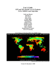
MODIS Collection 4 Active Fire Product User’s Guide
Version 2.2
Louis Giglio
Science Systems and Applications, Inc.
16 November 2005
Contents
1 Introduction
4
2 Overview of the MODIS Active Fire Products
2.1 Terminology . . . . . . . . . . . . . . . . . . . . . . . . . . . . . . . . . . . . . .
2.1.1 Granules . . . . . . . . . . . . . . . . . . . . . . . . . . . . . . . . . . .
2.1.2 Tiles . . . . . . . . . . . . . . . . . . . . . . . . . . . . . . . . . . . . . .
2.1.3 Climate Modeling Grid (CMG) . . . . . . . . . . . . . . . . . . . . . . .
2.1.4 Collections . . . . . . . . . . . . . . . . . . . . . . . . . . . . . . . . . .
2.2 Level 2 Fire Products: MOD14 (Terra) and MYD14 (Aqua) . . . . . . . . . . . . .
2.3 Level 2G Daytime and Nighttime Fire Products: MOD14GD/MOD14GN (Terra)
and MYD14GD/MYD14GN (Aqua) . . . . . . . . . . . . . . . . . . . . . . . . .
2.4 Level 3 8-Day Daily Composite Fire Products: MOD14A1 (Terra) and MYD14A1
(Aqua) . . . . . . . . . . . . . . . . . . . . . . . . . . . . . . . . . . . . . . . . .
2.5 Level 3 8-Day Summary Fire Products: MOD14A2 (Terra) and MYD14A2 (Aqua)
2.6 Climate Modeling Grid Fire Products (MOD14CMH, MYD4CMH, etc.) . . . . . .
2.7 The Rapid Response Fire Products . . . . . . . . . . . . . . . . . . . . . . . . . .
4
4
4
4
5
5
5
3 Obtaining the MODIS Active Fire Products
3.1 The EOS Data Gateway (EDG) . . . . . . . . . . . . . . . . . . . . . . . . . . . .
3.2 MODIS CMG Active-Fire Product Distribution . . . . . . . . . . . . . . . . . . .
9
10
16
4 Detailed Product Descriptions
4.1 MOD14 and MYD14 . . . . . . . . . . . .
4.1.1 Fire Mask . . . . . . . . . . . . . .
4.1.2 Detection Confidence . . . . . . . .
4.1.3 Algorithm Quality Assessment Bits
4.1.4 Fire Pixel Table . . . . . . . . . . .
4.1.5 Metadata . . . . . . . . . . . . . .
4.1.6 Example Code . . . . . . . . . . .
4.2 MOD14A1 and MYD14A1 . . . . . . . . .
4.2.1 Fire Mask . . . . . . . . . . . . . .
4.2.2 QA . . . . . . . . . . . . . . . . .
17
17
17
17
17
18
18
20
21
21
21
1
.
.
.
.
.
.
.
.
.
.
.
.
.
.
.
.
.
.
.
.
.
.
.
.
.
.
.
.
.
.
.
.
.
.
.
.
.
.
.
.
.
.
.
.
.
.
.
.
.
.
.
.
.
.
.
.
.
.
.
.
.
.
.
.
.
.
.
.
.
.
.
.
.
.
.
.
.
.
.
.
.
.
.
.
.
.
.
.
.
.
.
.
.
.
.
.
.
.
.
.
.
.
.
.
.
.
.
.
.
.
.
.
.
.
.
.
.
.
.
.
.
.
.
.
.
.
.
.
.
.
.
.
.
.
.
.
.
.
.
.
.
.
.
.
.
.
.
.
.
.
.
.
.
.
.
.
.
.
.
.
.
.
.
.
.
.
.
.
.
.
.
.
.
.
.
.
.
.
.
.
.
.
.
.
.
.
.
.
.
.
.
.
.
.
.
.
.
.
.
.
.
.
.
.
.
.
.
.
.
.
6
6
7
8
8
4.3
4.4
4.2.3 Example Code . . . . . . . . . . . . . . . . . .
MOD14A2 and MYD14A2 . . . . . . . . . . . . . . . .
4.3.1 Fire Mask . . . . . . . . . . . . . . . . . . . . .
4.3.2 QA . . . . . . . . . . . . . . . . . . . . . . . .
4.3.3 Example Code . . . . . . . . . . . . . . . . . .
CMG Fire Products (MOD14CMH, MYD14CMH, etc.) .
4.4.1 CMG Naming Convention . . . . . . . . . . . .
4.4.2 Data Layers . . . . . . . . . . . . . . . . . . . .
4.4.3 Global Metadata . . . . . . . . . . . . . . . . .
4.4.4 Climate Modeling Grid Navigation . . . . . . .
4.4.5 Example Code . . . . . . . . . . . . . . . . . .
5 Caveats and known Problems
5.1 Caveats . . . . . . . . . . . . . . . . . . . . . . . . .
5.1.1 Fire Pixel Locations vs. Gridded Fire Products
5.2 Collection 4 Known Problems . . . . . . . . . . . . .
5.2.1 Pre November 2000 Data Quality . . . . . . .
5.2.2 Regional False Alarms . . . . . . . . . . . . .
5.2.3 Detection Confidence . . . . . . . . . . . . . .
.
.
.
.
.
.
.
.
.
.
.
.
.
.
.
.
.
.
.
.
.
.
.
.
.
.
.
.
.
.
.
.
.
.
.
.
.
.
.
.
.
.
.
.
.
.
.
.
.
.
.
.
.
.
.
.
.
.
.
.
.
.
.
.
.
.
.
.
.
.
.
.
.
.
.
.
.
.
.
.
.
.
.
.
.
.
.
.
.
.
.
.
.
.
.
.
.
.
.
.
.
.
.
.
.
.
.
.
.
.
.
.
.
.
.
.
.
.
.
.
.
.
.
.
.
.
.
.
.
.
.
.
.
.
.
.
.
.
.
.
.
.
.
.
.
.
.
.
.
.
.
.
.
.
.
.
.
.
.
.
21
22
22
22
22
25
25
26
26
26
27
.
.
.
.
.
.
.
.
.
.
.
.
.
.
.
.
.
.
.
.
.
.
.
.
.
.
.
.
.
.
.
.
.
.
.
.
.
.
.
.
.
.
.
.
.
.
.
.
.
.
.
.
.
.
.
.
.
.
.
.
.
.
.
.
.
.
.
.
.
.
.
.
.
.
.
.
.
.
.
.
.
.
.
.
28
28
28
28
28
28
29
6 Frequently Asked Questions
6.1 Terra and Aqua Satellites . . . . . . . . . . . . . . . . . . . . . . . . . . . . . . .
6.1.1 Where can I find general information about the Terra and Aqua satellites? .
6.1.2 When were the Terra and Aqua satellites launched? . . . . . . . . . . . . .
6.2 General MODIS Questions . . . . . . . . . . . . . . . . . . . . . . . . . . . . . .
6.2.1 Where can I find Algorithm Technical Basis Documents (ATBDs) for the
MODIS land products? . . . . . . . . . . . . . . . . . . . . . . . . . . . .
6.3 General Fire Product Questions . . . . . . . . . . . . . . . . . . . . . . . . . . . .
6.3.1 How are the fires and other thermal anomalies identified in the MODIS fire
products detected? . . . . . . . . . . . . . . . . . . . . . . . . . . . . . .
6.3.2 What is the smallest fire size that can be detected with MODIS? What about
the largest? . . . . . . . . . . . . . . . . . . . . . . . . . . . . . . . . . .
6.3.3 Why didn’t MODIS detect a particular fire? . . . . . . . . . . . . . . . . .
6.3.4 How do I obtain the MODIS fire products? . . . . . . . . . . . . . . . . .
6.3.5 What validation of the MODIS active fire products has been performed? . .
6.3.6 I don’t want to bother with strange file formats and/or an unfamiliar ordering
interface and/or very large data files. Can’t you just give me the locations
of fire pixels in plain ASCII files and I’ll bin them myself? . . . . . . . . .
6.3.7 How well can MODIS detect understory burns? . . . . . . . . . . . . . . .
6.4 Level 2 Fire Products . . . . . . . . . . . . . . . . . . . . . . . . . . . . . . . . .
6.4.1 Why do the Level 2 product files vary in size? . . . . . . . . . . . . . . . .
6.4.2 How should the different fire detection confidence classes be used? . . . .
6.4.3 How can I take data from the fire-pixel-table SDSs (i.e., the one-dimensional
SDSs with the prefix “FP ”) and place the values in the proper locations of
a two-dimensional array that matches the swath-based “fire mask” and “algorithm QA” SDSs? . . . . . . . . . . . . . . . . . . . . . . . . . . . . .
2
30
30
30
30
30
30
30
30
31
31
31
31
31
31
32
32
32
32
6.4.4
6.5
6.6
6.7
Why are the values of the fire radiative power (FRP) I see in the Level 2
product inconsistent with those I find in the CMG products and published
in various journal papers? . . . . . . . . . . . . . . . . . . . . . . . . . .
6.4.5 What is the area of a MODIS pixel at the Earth’s surface? . . . . . . . . .
Level 3 Tiled Fire Products . . . . . . . . . . . . . . . . . . . . . . . . . . . . . .
6.5.1 Why do coastlines in the tile-based Level 3 products looked so warped? . .
Level 3 CMG Fire Products . . . . . . . . . . . . . . . . . . . . . . . . . . . . . .
6.6.1 I need to reduce the resolution of the 0.5◦ CMG fire product to grid cells
that are a multiple of 0.5◦ in size How do I go about doing this? . . . . . .
6.6.2 Why don’t you distribute a daily CMG fire product? . . . . . . . . . . . .
6.6.3 Why don’t you distribute the CMG fire products as plain binary (or ASCII)
files? . . . . . . . . . . . . . . . . . . . . . . . . . . . . . . . . . . . . .
6.6.4 Where can I find information about the FITS file format? . . . . . . . . . .
6.6.5 How can I display images in FITS files? . . . . . . . . . . . . . . . . . . .
Hierarchical Data Format (HDF) . . . . . . . . . . . . . . . . . . . . . . . . . . .
6.7.1 What are HDF files? . . . . . . . . . . . . . . . . . . . . . . . . . . . . .
6.7.2 How do I read HDF4 files? . . . . . . . . . . . . . . . . . . . . . . . . . .
6.7.3 Can’t I just skip over the HDF header and read the data directly? . . . . . .
6.7.4 How can I list the contents of HDF4 files? . . . . . . . . . . . . . . . . . .
7 References
7.1 Journal Papers and Technical Reports . . . . . . . . . . . . . . . . . . . . . . . .
7.2 Relevant Web and FTP Sites . . . . . . . . . . . . . . . . . . . . . . . . . . . . .
3
33
33
35
35
35
35
37
37
37
37
40
40
40
40
40
41
41
41
1 Introduction
This document contains the most current information about the Terra and Aqua Moderate Resolution
Imaging Spectrometer (MODIS) fire products. It is intended to provide the end user with practical
information regarding their use and misuse, and to explain some of the more obscure and potentially
confusing aspects of the fire products and MODIS products in general.
2 Overview of the MODIS Active Fire Products
Here we provide a general overview of the MODIS active fire products. More detailed descriptions
of these products and example ingest code can be found in Section 4.
2.1
Terminology
Before proceeding with a description of the MODIS Fire Products, we must briefly describe some
of the terminology that you will encounter when ordering and working with MODIS products.
Specifically, we’ll define the terms granule, tile, and collection, and the acronym CMG, as each
applies to the MODIS products.
2.1.1 Granules
A granule is simply an unprojected segment of the MODIS orbital swath containing about 5 minutes
of data. MODIS Level 0, Level 1, and Level 2 products are granule-based.
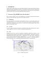
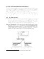
2.1.2 Tiles
MODIS Level 2G, Level 3, and Level 4 products are defined on a global 250 m, 500 m, or 1 km
sinusoidal grid (the particular spatial resolution is product-dependent). Because these grids are
unmanageably large in their entirety (43200 × 21600 pixels at 1 km, and 172800 × 86400 pixels
at 250 m), they are divided into fixed tiles approximately 10 ◦ × 10◦ in size. Each tile is assigned a
horizontal (H) and vertical (V) coordinate, ranging from 0 to 35 and 0 to 17, respectively (Figure 1).
The tile in the upper left (i.e. northernmost and westernmost) corner is numbered (0,0).
Figure 1: MODIS tiling scheme.
4
2.1.3 Climate Modeling Grid (CMG)
MODIS Level 3 and Level 4 products can also be defined on a coarser-resolution Climate Modelling
Grid (CMG). The objective is to provide the MODIS land products at consistent low resolution spatial and temporal scales suitable for global modeling. In practice, there is a fair amount of variation
in the spatial and temporal gridding conventions used among the MODIS land CMG products.
2.1.4 Collections
Reprocessing of the entire MODIS data archive is periodically performed so as to incorporate better
calibration, algorithm refinements, and improved upstream products into all MODIS products. The
updated MODIS data archive resulting from each reprocessing is referred to as a collection. Later
collections supersede all earlier collections.
For the Terra MODIS, Collection 1 consists of the first products generated following launch.
Terra MODIS data were first reprocessed for the first time in June 2001 to produce Collection 3.
Note that this first reprocessing was numbered Collection 3, rather than Collection 2, as one would
expect. Collection 3 was also the first produced for the Aqua MODIS products. Collection 4
reprocessing was initiated in December 2002 for the Terra MODIS, and somewhat later for the
Aqua MODIS, and it forms the current archive of the MODIS products. Currently, Collection 5
reprocessing is scheduled to begin in early 2006.
2.2
Level 2 Fire Products: MOD14 (Terra) and MYD14 (Aqua)
This is the most basic fire product in which active fires and other thermal anomalies, such as volcanoes, are identified. The Level 2 product is defined in the MODIS orbit geometry covering an area
of approximately 2340 by 2030 km in the across- and along-track directions, respectively. It is used
to generate all of the higher-level fire products, and contains the following components:
• An active fire mask that flags fires and other relevant pixels (e.g. cloud);
• a pixel-level quality assurance (QA) image that includes 19 bits of QA information about each
pixel;
• a fire-pixel table which provides 19 separate pieces of radiometric and internal-algorithm
information about each fire pixel detected within a granule;
• extensive mandatory and product-specific metadata;
• a grid-related data layer to simplify production of the Climate Modeling Grid (CMG) fire
product (Section 2.6).
Product-specific metadata within the Level 2 fire product includes the number of cloud, water,
non-fire, fire, unknown, and other pixels occurring within a granule to simplify identification of
granules containing fire activity.
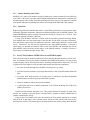
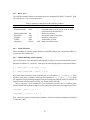
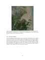
Figure 2 shows an example of the active fire mask for the Terra granule acquired on 19 August
2002 at 03:00. In this image, water is shown in blue, clouds in violet, non-fire land pixels in grey,
and fire pixels in white. The bottom edge of the image points in the satellite’s along-track direction.
5
Figure 2: Example MOD14 granule with water shown in
blue, clouds in purple, clear land in grey, and active fires in
white. The along-track direction points toward the top of
the page.
2.3
Level 2G Daytime and Nighttime Fire Products: MOD14GD/MOD14GN (Terra)
and MYD14GD/MYD14GN (Aqua)
The Level 2 active fire products sensed over daytime and nighttime periods are binned without
resampling into an intermediate data format referred to as Level 2G. The Level 2G format provides
a convenient geocoded data structure for storing granules and enables the flexibility for subsequent
temporal compositing and reprojection. The Level 2G fire products are a temporary, intermediate
data source used solely for producing the Level 3 fire products and are consequently not available
from the permanent MODIS data archive.
2.4
Level 3 8-Day Daily Composite Fire Products: MOD14A1 (Terra) and MYD14A1
(Aqua)
The MODIS daily Level 3 fire product is tile based, with each product file spanning one of the 460
MODIS tiles, 326 of which contain land pixels. The product is a 1-km gridded composite of fire
pixels detected in each grid cell over each daily (24-hour) compositing period. For convenience,
eight days of data are packaged into a single file.
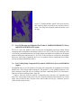
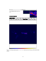
Figure 3 shows the Terra fire mask for 19 September 2001 from the 14-21 September 2001
daily Level 3 fire product (Collection 4). The tile is located in Northern Australia (H31V10). In this
image, water is shown in blue, clouds in violet, non-fire land pixels in grey, “unknown” pixels in
yellow, and fire pixels in white.
6
Figure 3: Example of MOD14A1 fire mask
for a tile in Northern Australia. Water is
shown in blue, clouds in violet, non-fire land
pixels in grey, and fire pixels in white.
2.5
Level 3 8-Day Summary Fire Products: MOD14A2 (Terra) and MYD14A2 (Aqua)
The MODIS daily Level 3 8-day summary fire product is tile-based, with each product file spanning
one of the 460 MODIS tiles, of which 326 contain land pixels. The product is a 1-km gridded
composite of fire pixels detected in each grid cell over each 8-day compositing period.
Figure 4 shows the 8-day summary fire mask from the 26 June - 3 July 2002 8-day Level 3
Terra fire product. The tile is located in the eastern United States (H08V05). The 8-day composite
is the maximum value of the individual Level 2 pixel classes that fell into each 1-km grid cell over
the entire 8-day compositing period. Due to the way the three different fire-pixel confidence levels
are defined (Section 4.1), the Level 3 8-day fire product is sometimes said to contain the “mostconfident detected fires”. This description can sometimes be misleading in that pixel values are
defined even for those grid cells in which no fire pixels were detected.
Figure 4: Example of 8-day MOD14A2 fire
mask for a tile in eastern United States. Water is shown in blue, clouds in violet, non-fire
land pixels in grey, and fire pixels in white.
7
2.6
Climate Modeling Grid Fire Products (MOD14CMH, MYD4CMH, etc.)
The CMG fire products are gridded statistical summaries of fire pixel information intended for use
in regional and global modeling. The products are currently generated at 0.5 ◦ spatial resolution for
time periods of one calendar month (MOD14CMH/MYD14CMH) and eight days (MOD14C8H/MYD14C8H).
Higher resolution 0.25◦ CMG fire products will eventually be produced as well. An example of the
corrected fire pixel count layer of the product is shown in Figure 5.
Figure 5: Example of the corrected fire pixel count data layer from the January 2001 CMG fire
product.
2.7
The Rapid Response Fire Products
The MODIS Rapid Response System produces near-real time global imagery including true- and
false-color corrected reflectance superimposed with fire locations (Figure X), Normalized Difference Vegetation Index (NDVI), and land surface temperature. Burned area maps will be added in
the near future. The locations of Terra and Aqua MODIS fire pixels are also available in ASCII
files. For further information see the MODIS Rapid Response web site 1 .
1
http://rapidfire.sci.gsfc.nasa.gov
8
3 Obtaining the MODIS Active Fire Products
All MODIS products are available to users free of charge. There are currently three different ways
to obtain the MODIS fire products. Not all products are available through each of these methods.
See Table 1.
Table 1: MODIS fire product availability.
Product
Source
Level 2 and most Level 3 fire products:
MOD14, MYD14
MOD14A1, MYD14A1
MOD14A2, MYD14A2
EOS Data Gateway (see Section 3.1).
Level 2G fire products:
MOD14GD, MOD14GN
MYD14GD, MYD14GN
Unavailable (not archived).
CMG fire products:
MOD14CMH, MYD14CMH
MOD14C8H, MYD14C8H
University of Maryland (see Section 3.2).
Active fire locations in ASCII and ESRI shape file MODIS Web Fire Mapper
format.
Fire and corrected-reflectance JPEG imagery and MODIS Land Rapid Response System
ASCII fire locations.
9
3.1
The EOS Data Gateway (EDG)
Most of the MODIS land products may be obtained from the Land Processes Distributed Active
Archive Center (LP-DAAC) using a Web-based interface known as the EOS Data Gateway (EDG).
Below is a brief tutorial for using the EDG to order the fire products.
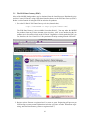
1. Go to the LP-DAAC EOS Data Gateway web site (shown below):
http://edcimswww.cr.usgs.gov/pub/imswelcome/
The EOS Data Gateway is also available from other DAACs. You may order the MODIS
fire products from any of these alternate sites since they “talk” to one another, but the fire
products are in fact archived only at the LP-DAAC. Regardless of which particular EDG you
use, therefore, the Level 2 and Level 3 fire products will end up coming from the LP-DAAC.
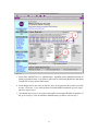
2. Register (select “Become a registered user”) or enter as guest. Registering will prevent you
from having to reenter contact information each time you place an order. When done registering, enter the Data Gateway (“Enter as registered user”).
10
3. Select either “MODIS/Terra” or “MODIS/Aqua”, depending on the MODIS instrument for
which you would like data. If you’d like to order both Terra and Aqua MODIS fire data during
a single EDG session, choose either button.
4. Scroll through the list box until you find the entry for the particular fire product you’d like
to order. Click on it. If you want products from both MODIS instruments go on to Step 5,
otherwise skip to Step 6.
5. (You should only be here if you want to order both Terra and Aqua MODIS fire products. If
not, go on to Step 6.) Click on whichever MODIS button you did not select in Step 3.
11
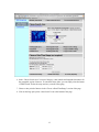
6. In the “Choose Search Area” section of the page, enter latitude and longitude boundaries for
the geographic region of interest. To search the entire globe, you can simply select the button
“Global Search” (below the map) and save yourself some typing.
7. Choose a time period of interest in the “Choose a Data/Time Range” section of the page.
8. Click on the large pale yellow “Start Search” icon at the bottom of the page.
12
9. Wait while the system searches for products meeting your search criteria. This usually takes
a few minutes.
13
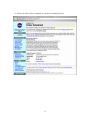
10. You will presented with a listing of all files matching your search criteria. Select those that
you would like to order and click on the yellow “Add selections to cart” button.
11. The display will change slightly and you may then select a delivery method for the files you
have selected. Choose “FtpPull” if you intend to download the data using ftp.
12. Click on the “Go to Step 2: Order Form” button.
13. Update your contact information (or enter it if you are logged in as a guest) and click on the
“Submit Order Now!” button.
14. Wait while the system process your request. You will receive updates resembling those in
Step 9 while this is happening.
14
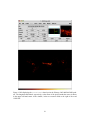
15. When your order has been completed you should see something like this:
15
3.2
MODIS CMG Active-Fire Product Distribution
At present the CMG products are distributed from the University of Maryland via the ftp server
fuoco.geog.umd.edu (login name is fire and password is burnt) in the directory modis/cmg.
For convenience, the products are distributed in multiple, standard data formats. Currently HDF and
Flexible Image Transport System (FITS) files are available; additional formats may be produced in
the future.
16
4 Detailed Product Descriptions
4.1
MOD14 and MYD14
MOD14/MYD14 is the most basic fire product in which active fires and other thermal anomalies,
such as volcanoes, are identified. The Level 2 product is defined in the MODIS orbit geometry
covering an area of approximately 2340 by 2030 km in the across- and along-track directions, respectively. It is used to generate all of the higher-level fire products.
4.1.1 Fire Mask
The fire mask is the principle component of the Level 2 MODIS fire product, and is stored as an
8-bit unsigned integer Scientific Data Set (SDS) named “fire mask”. In it, individual 1-km pixels
are assigned one of nine classes. The meaning of each class is listed in Table 2.
Table 2: MOD14/MYD14 fire mask pixel classes.
Class
0
2
3
4
5
6
7
8
9
Meaning
not processed (missing input data)
not processed (other reason)
water
cloud
non-fire clear land
unknown
low-confidence fire
nominal-confidence fire
high-confidence fire
A pixel class of 1 was defined for historical reasons but will never actually occur in the fire mask.
4.1.2 Detection Confidence
A detection confidence intended to help users gauge the quality of individual fire pixels is included
in the Level 2 fire product. This confidence estimate, which ranges between 0% and 100%, is used to
assign one of the three fire classes (low-confidence fire, nominal-confidence fire, or high-confidence
fire) to all fire pixels within the fire mask.
In some applications errors of comission (or false alarms) are particularly undesirable, and for
these applications one might be willing to trade a lower detection rate to gain a lower false alarm
rate. Conversely, for other applications missing any fire might be especially undesirable, and one
might then be willing to tolerate a higher false alarm rate to ensure that fewer true fires are missed.
Users requiring fewer false alarms may wish to retain only nominal- and high-confidence fire pixels,
and treat low-confidence fire pixels as clear, non-fire, land pixels. Users requiring maximum fire
detectability who are able to tolerate a higher incidence of false alarms should consider all three
classes of fire pixels.
4.1.3 Algorithm Quality Assessment Bits
Pixel-level QA is stored in a 32-bit unsigned integer SDS named “algorithm QA”, with individual
fields stored in specific bits. The exact meaning of these bit fields is defined in the Level 2 Fire
17
Product file specification.
4.1.4 Fire Pixel Table
The fire pixel table is simply a collection of SDSs containing relevant information about individual
fire pixels detected within a granule. Due to HDF file format and library limitations, the Fire Pixel
Table is stored as 19 separate SDSs. A brief summary of these SDSs is provided in Table 3.
Table 3:
SDS Name
FP line
FP sample
FP latitude
FP longitude
FP R2
FP T21
FP T31
FP MeanT21
FP MeanT31
FP MeanDT
FP MAD T21
FP MAD T31
FP MAD DT
FP power
FP AdjCloud
FP AdjWater
FP WinSize
FP NumValid
FP confidence
Collection 4 Level 2 fire product SDSs comprising the “fire pixel table”.
Data Type Unit
Description
int16
Granule line of fire pixel.
int16
Granule sample of fire pixel.
float32
degrees Latitude of fire pixel.
float32
degrees Longitude of fire pixel.
float32
Near-IR (band 2) reflectance of fire pixel (daytime only).
float32
K
Channel 21/22 brightness temperature of fire pixel.
float32
K
Channel 31 brightness temperature of fire pixel.
float32
K
Background channel 21/22 brightness temperature.
float32
K
Background channel 31 brightness temperature.
float32
K
float32
K
float32
K
float32
K
float32
W m−2 Fire radiative power per unit area.
uint8
Number of adjacent cloud pixels.
uint8
Number of adjacent water pixels.
uint8
Background window size.
int16
Number of valid background pixels.
uint8
%
Detection confidence estimate.
4.1.5 Metadata
Every MODIS product carries with it ECS-mandated metadata stored in the HDF global attributes
CoreMetadata.0 and ArchiveMetadata.0. Each attribute is an enormous string of ASCII characters
encoding many separate metadata fields in Parameter Value Language (PVL). Among other information, the ArchiveMetadata.0 attribute usually contains product-specific metadata included at the
discretion of the PI. However, since the PVL is awkward to read and tedious to parse, we have stored
many of the product-specific metadata fields as standard HDF global attributes. These are summarized in Table 4. Descriptions of the product-specific metadata stored in the ECS ArchiveMetadata.0
attribute may be found in the MOD14/MYD14 file specification (see Section 7.2).
18
Table 4: MODIS Level 2 fire product metadata stored as standard gobal HDF attributes.
Attribute Name
Description
FirePix
Number of fire pixels detected in granule.
MissingPix
Number of pixels in granule lacking valid data for processing.
LandPix
Number of land pixels in granule.
WaterPix
Number of water pixels in granule.
WaterAdjacentFirePix
Number of fire pixels that are adjacent to one or more water pixels.
CloudAdjacentFirePix Number of fire pixels that are adjacent to one or more cloud pixels.
UnknownPix
Number of pixels assigned a class of unknown in granule.
LandCloudPix
Number of land pixels obscured by cloud in granule.
WaterCloudPix
Number of water pixels obscured by cloud in granule (always 0
since the internal cloud mask is not applied over water pixels).
GlintPix
Number of pixels in granule contaminated with Sun glint.
GlintRejectedPix
Number of tentative fire pixels that were rejected due to apparent
Sun glint contamination.
CoastRejectedPix
Number of tentative fire pixels that were rejected due to apparent
water contamination of the contextual neighborhood.
HotSurfRejectedPix
Number of tentative fire pixels that were rejected as apparent hot
desert surfaces.
DayPix
Number of daytime pixels in granule.
NightPix
Number of nighttime pixels in granule.
Satellite
Name of satellite (“Terra” or “Aqua”).
ProcessVersionNumber Program version string (e.g. “4.3.3”).
MOD021KM input file File name of MOD021KM (Terra) or MYD021KM (Aqua)
Level 1B radiance input granule.
MOD03 input file
File name of MOD03 (Terra) or MYD03 (Aqua) geolocation input
granule.
SystemID
Operating system identification string.
19
4.1.6 Example Code
Example 1: IDL code for reading the “fire mask” SDS in the MODIS Level 2 fire product.
mod14_file = MOD14.A2002177.1830.004.2002192223417.hdf
; open the HDF file for reading
sd_id = HDF_SD_START(mod14_file, /READ)
; find the SDS index to the MOD14 fire mask
index = HDF_SD_NAMETOINDEX(sd_id, ’fire mask’)
; select and read the entire fire mask SDS
sds_id = HDF_SD_SELECT(sd_id, index)
HDF_SD_GETDATA, sds_id, fire_mask
; finished with SDS
HDF_SD_ENDACCESS, sds_id
; finished with HDF file
HDF_SD_END, sd_id
20
4.2
MOD14A1 and MYD14A1
The MOD14A1 and MTD14A1 daily Level 3 fire products are tile-based, with each product file
spanning one of the 460 MODIS tiles, of which 326 contain land pixels. The product is a 1-km
gridded composite of fire pixels detected in each grid cell over each daily (24-hour) compositing
period. For convenience, eight days of data are packaged into a single file.
NOTE: The Collection 5 MOD14A1 and MYD14A1 fire products will differ
significantly from the current Collection 4 versions of these products. Improvements are being implemented in preparation for an February 2006 Collection 5 reprocessing, and will require changes to the both the structure and
meaning of the product data layers. These changes will most likely break existing code written to ingest the Collection 4 MOD14A1 and MYD14A1 products.
4.2.1 Fire Mask
The fire mask is stored as an 8 (or less) × 1200 × 1200, 8-bit unsigned integer SDS awkwardly
named “most confident detected fire” for historical reasons. The SDS contains eight successive daily
fire masks for a specific MODIS tile. Each of these daily masks is a maximum value composite of
the Level 2 fire product pixel classes (Table 2) for those swaths overlapping the MODIS tile during
that day. Product files containing less than eight days of data will occasionally be encountered
during time periods of missing data and should be handled in ingest software.
4.2.2 QA
Each of the daily fire masks has a corresponding QA layer. This layer is simply a copy of the
pixel-level QA from the particular swath pixel of the Level 2 product that populates the Level 3 grid
cell.
4.2.3 Example Code
Example 2: MATLAB code to read the Level 3 MODIS daily fire mask, using the MATLAB routine
hdfread. This is probably the easiest way to read individual HDF SDSs in MATLAB.
mod14a1_file = ’MOD14A1.A2001289.h23v02.004.2003164035111.hdf’
% read entire "most confident detected fire" SDS in one shot
fire_mask = hdfread(mod14a1_file, ’most confident detected fire’);
% display fire mask for the first day in MOD14A1/MYD14A1
% note how image is transposed so that North appears on top
imagesc(fire_mask(:,:,1)’);
21
4.3
MOD14A2 and MYD14A2
The MOD14A2 (Terra) and MYD14A2 (Aqua) daily Level 3 8-day summary fire products are tilebased, with each product file spanning one of the 460 MODIS tiles, 326 of which contain land
pixels. The product is a 1-km gridded composite of fire pixels detected in each grid cell over each
8-day compositing period.
NOTE: The Collection 5 MOD14A2 and MYD14A2 fire products will differ
significantly from the current Collection 4 versions of these products. Improvements are being implemented in preparation for a February 2006 Collection 5 reprocessing, and will require changes to the both the structure and
meaning of the product data layers. These changes will most likely break existing code written to ingest the Collection 4 MOD14A2 and MYD14A2 products.
4.3.1 Fire Mask
The fire mask is stored as a 1200 × 1200 8-bit unsigned integer SDS awkwardly named “most
confident detected fire” for historical reasons.
4.3.2 QA
The QA layer contains pixel-level quality assessment information stored in a 1200 × 1200 8-bit
unsigned integer image. Only the two least significant bits are used, and the values stored in this
array correspond to the original Land Data Operational Product Evaluation (LDOPE) QA summary.
See Roy et al. (2002) for more information about these values.
4.3.3 Example Code
Example 3: MATLAB code to read the Level 3 MODIS 8-day fire mask, using the MATLAB routine
hdfread. This is probably the easiest way to read individual HDF SDSs in MATLAB.
mod14a2_file = ’MYD14A2.A2004193.h08v08.004.2004207151726.hdf’
% read entire "most confident detected fire" SDS in one shot
fire_mask = hdfread(mod14a2_file, ’most confident detected fire’);
% display fire mask (transposed so that North appears on top)
imagesc(fire_mask’);
22
Example 4: Longer version of MATLAB code to read the Level 3 MODIS 8-day fire mask. This is
probably the better approach to use if multiple subsets of an SDS will be read in sequence since the
HDF file will be opened and closed only once. (The shorter approach using hdfread requires that
the file be opened and closed for each read.)
mod14a2_file = ’MYD14A2.A2004193.h08v08.004.2004207151726.hdf’
sd_id = hdfsd(’start’, mod14a2_file, ’DFACC_RDONLY’);
sds_index = hdfsd(’nametoindex’, sd_id, ’most confident detected fire’);
sds_id = hdfsd(’select’, sd_id, sds_index);
% prepare to read entire SDS (always 1200 x 1200 pixels in size)
start = [0,0];
edges = [1200,1200];
[fire_mask, status] = hdfsd(’readdata’, sds_id, start, [], edges);
status = hdfsd(’endaccess’, sds_id);
status = hdfsd(’end’, sd_id);
% display fire mask (transposed so that North appears on top)
imagesc(fire_mask’);
23
Example 5: C code for reading Level 3 MODIS 8-day fire mask using HDF library functions.
#include <stdio.h>
#include <stdlib.h>
#include "mfhdf.h"
#define ROWS 1200
#define COLS 1200
main(int argc, char **argv)
{
int32 sd_id, sds_index, sds_id;
int32 rank, data_type, nattr, dim_sizes[MAX_VAR_DIMS];
int32 start[2], int32 edges[2];
char *infile;
int i, j;
long nfire;
uint8 fire_mask[ROWS][COLS];
infile = "MOD14A2.A2002169.h09v05.004.2003240104900.hdf";
if ((sd_id = SDstart(infile, DFACC_READ)) == FAIL) exit(1);
start[0] = start[1] = 0;
edges[0] = ROWS;
edges[1] = COLS;
if ((sds_index = SDnametoindex(sd_id,
"most confident detected fire")) == FAIL) exit(2);
if ((sds_id = SDselect(sd_id, sds_index)) == FAIL) exit(3);
if (SDgetinfo(sds_id, (char *) NULL, &rank, dim_sizes, &data_type,
&nattr) == FAIL) exit(4);
/* check rank and data type */
if (rank != 2) exit(5);
if (data_type != DFNT_UINT8) exit(6);
if (SDreaddata(sds_id, start, NULL, edges,
(void *) fire_mask) == FAIL) exit(7);
if (SDendaccess(sds_id) == FAIL) exit(8);
if (SDend(sd_id) == FAIL) exit(9);
/* simple example: count grid cells containing fires */
nfire = 0;
for (i = 0; i < ROWS; i++) {
for (j = 0; j < COLS; j++)
if (fire_mask[i][j] >= 7) nfire++;
}
printf("%d grid cells containing fires.\n", nfire);
exit(0);
}
24
4.4
CMG Fire Products (MOD14CMH, MYD14CMH, etc.)
The CMG fire products are gridded statistical summaries of fire pixel information intended for use in
regional and global modeling, and are currently generated at 0.5 ◦ spatial resolution for time periods
of one calendar month (MOD14CMH/MYD14CMH) and eight days (MOD14C8H/MYD14C8H).
Higher resolution 0.25◦ CMG fire products will eventually be produced as well.
At present the CMG products are distributed from the University of Maryland via anonymous ftp
(see Section 3.2). For convenience, the products are distributed in multiple, standard data formats.
Currently HDF and Flexible Image Transport System (FITS) files are available; additional formats
may be produced in the future.
4.4.1 CMG Naming Convention
Monthly CMG fire products. The file names of the monthly CMG product files have the structure
M?D14CM?.YYYYMM.CCC.VV.XXX, where M?D14CM? is a prefix 2 encoding the satellite
and product spatial resolution (see Figure 6), YYYY is the four-digit product year, MM is the
two-digit calendar month, CCC denotes the Collection (see Section 2.1.4), VV denotes the
product version within a Collection, and XXX is a suffix indicating the file format.
Eight-day CMG fire products. The file names of the 8-day CMG product files have the structure
M?D14C8?.YYYYDDD.CCC.VV.XXX, where M?D14C8? is a prefix encoding the satellite
and product spatial resolution (see Figure 6), YYYY is the four-digit product year, DDD is the
two-digit calendar month, CCC denotes the Collection (see Section 2.1.4), VV denotes the
product version within a Collection, and XXX is a suffix indicating the file format.
Figure 6: MODIS CMG fire product naming prefix (ESDT) convention.
2
In MODIS-speak this prefix is usually referred to as an Earth Science Data Type (ESDT).
25
4.4.2 Data Layers
The CMG fire products contain seven separate data layers summarized in Table 5. For the 0.5 ◦ products each layer is a 720 × 360 numeric array.
Table 5: Summary of data layers in the CMG fire products.
Layer Name
Data Type Unit Description
CorrFirePix
int16
Corrected number of fire pixels.
CloudCorrFirePix
int16
Corrected number of fire pixels, with an additional correction for cloud cover.
MeanCloudFraction int8
Mean cloud fraction.
RawFirePix
int16
Uncorrected count of fire pixels.
CloudPix
int32
Number of cloud pixels.
TotalPix
int32
Total number of pixels.
MeanPower
float32
MW Mean fire radiative power.
4.4.3 Global Metadata
Global metadata are stored as global attributes in the HDF product files, and primary-HDU keywords in the FITS product files.
4.4.4 Climate Modeling Grid Navigation
Forward navigation. Given the latitude and longitude (in degrees) of a point on the Earth’s surface,
the image coordinates (x,y) of the 0.5◦ CMG grid cell containing this point are computed as follows:
y = trunc((90.0 - latitude) / 0.5)
x = trunc((longitude + 180.0) / 0.5)
Here trunc denotes truncation of the fractional part of a real number, i.e. trunc(2.2) = 2. These
equations yield image coordinates satisfying the inequalities 0 ≤ x ≤ 719, 0 ≤ y ≤ 319, which
are appropriate for programming languages using zero-based array indexing such as C and IDL; for
languages using one-based array indexing (e.g. Fortran, MATLAB) add 1.
Inverse navigation. Given coordinates (x,y) of a particular grid cell in the 0.5 ◦ CMG fire products, the latitude and longitude (in degrees) of the center of the grid cell may be computed as follows:
latitude = 89.75 - 0.5 × y
longitude = -179.75 + 0.5 × x
Here, x and y are again zero-based image coordinates; for one-based image coordinates first subtract
1 from both x and y.
26
4.4.5 Example Code
Example 6: IDL code for reading the cloud-corrected fire pixel layer within the MODIS Collection
4 CMG monthly and 8-day fire products (HDF4 format).
; read "CloudCorrFirePix" array in CMG product (HDF4 format)
cmg_file = ’MYD14CMH.200412.004.01.hdf’
sd_id = HDF_SD_START(cmg_file, /READ)
index = HDF_SD_NAMETOINDEX(sd_id, ’CloudCorrFirePix’)
sds_id = HDF_SD_SELECT(sd_id, index)
HDF_SD_GETDATA, sds_id, CloudCorrFirePix
HDF_SD_ENDACCESS, sds_id
HDF_SD_END, sd_id
Example 7: IDL code for reading the cloud-corrected fire pixel layer within the MODIS Collection
4 CMG monthly and 8-day fire products (FITS format).
; read "CloudCorrFirePix" array in CMG product (FITS format)
cmg_file = ’MYD14CMH.200412.004.01.fits’
FITS_OPEN, cmg_file, fcb
ihdu = FIND_HDU(fcb, ’CloudCorrFirePix’)
READ_ARRAY, fcb, ihdu, CloudCorrFirePix, ndims, dims
FITS_CLOSE, fcb
27
5 Caveats and known Problems
5.1
Caveats
Some caveats to bear in mind when using the MODIS fire products:
5.1.1 Fire Pixel Locations vs. Gridded Fire Products
We urge caution in using fire pixel locations in lieu of the 1-km gridded MODIS fire products. The
former includes no information about cloud cover or missing data and, depending on the sort of
analysis that is being performed, it is sometimes possible to derive misleading (or even incorrect)
results by not accounting for these other types of pixels. It is also possible to grossly misuse fire
pixel locations, even for regions and time periods in which cloud cover and missing observations
are negligible. Some caveats to keep in mind when using MODIS fire pixel locations:
• The fire pixel location files allow users to temporally and spatially bin fire counts arbitrarily.
However, severe temporal and spatial biases may arise in any MODIS fire time series analysis
employing time intervals shorter than about eight days.
• Known fires for which no entries occur in the fire-pixel location files are not necessarily
missed by the detection algorithm. Cloud obscuration, a lack of coverage, or a misclassification in the land/sea mask may instead be responsible, but with only the information provided
in the fire location files this will be impossible to determine.
5.2
Collection 4 Known Problems
5.2.1 Pre November 2000 Data Quality
Prior to November 2000, the Terra MODIS instrument suffered from several hardware problems
that adversely affected all of the MODIS fire products. In particular, some detectors were rendered
dead or otherwise unusable in an effort to reduce unexpected crosstalk between many of the 500 m
and 1 km bands. The dead detectors are known to introduce at least three specific artifacts in the
pre-November 2000 fire products: striping, undetected small fires, and undetected large fires. In
some very rare instances severe miscalibration of band-21 in the first weeks of the MODIS data
archive (February and March 2000) will cause entire scan lines to be identified as fire.
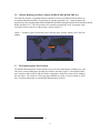
5.2.2 Regional False Alarms
Recurring false alarms attributed to industrial sources and urban land-cover boundaries have have
been observed in eastern China near Shanghai and Shaoxing. A particularly bad example is shown
in Figure 7.
28
Figure 7: Example of false alarms near Shanghai from the Terra MODIS, 18 July 2004 02:45 UTC.
Pixels identified as containing fires are outlined in red, superimposed on a true color corrected
reflectance image (courtesy of Jacques Descloitres).
5.2.3 Detection Confidence
A detection confidence intended to help users gauge the quality of individual fire pixels is included
in the Level 2 fire product. This confidence estimate, which ranges between 0% and 100%, is used to
assign one of the three fire classes (low-confidence fire, nominal-confidence fire, or high-confidence
fire) to all fire pixels within the fire mask. In the Collection 4 fire product this confidence estimate
does not adequately identify highly questionable, low confidence fire pixels. Such pixels, which
by design should have a confidence close to 0%, are too often assigned much higher confidence
estimates of 50% or higher. This will be corrected for Collection 5.
29
6 Frequently Asked Questions
6.1
Terra and Aqua Satellites
6.1.1 Where can I find general information about the Terra and Aqua satellites?
See NASA’s Terra and Aqua web sites for a start:
http://terra.nasa.gov/ http://aqua.nasa.gov/
6.1.2 When were the Terra and Aqua satellites launched?
18 December 1999 and 4 May 2002, respectively.
6.2
General MODIS Questions
6.2.1 Where can I find Algorithm Technical Basis Documents (ATBDs) for the MODIS land
products?
ATBDs for all of the MODIS land products are available from MODARCH 3 . Note that many are
not up to date. In particular, the fire product ATBD pre-dates the launch of both the Terra and Aqua
satellites, and describes the very obsolete pre-launch detection algorithm.
6.3
General Fire Product Questions
6.3.1 How are the fires and other thermal anomalies identified in the MODIS fire products
detected?
Fire detection is performed using a contextual algorithm (Giglio et al., 2003) that exploits the strong
emission of mid-infrared radiation from fires (Dozier, 1981; Matson and Dozier, 1981). The algorithm examines each pixel of the MODIS swath, and ultimately assigns to each one of the following
classes: missing data, cloud, water, non-fire, fire, or unknown.
Pixels lacking valid data are immediately classified as missing data and excluded from further
consideration. Cloud and water pixels are identified using cloud and water masks, and are assigned
the classes cloud and water, respectively. Processing continues on the remaining clear land pixels.
A preliminary classification is used to eliminate obvious non-fire pixels. For those potential fire pixels that remain, an attempt is made to use the neighboring pixels to estimate the radiometric signal
of the potential fire pixel in the absence of fire. Valid neighboring pixels in a window centered on
the potential fire pixel are identified and are used to estimate a background value. If the background
characterization was successful, a series of contextual threshold tests are used to perform a relative
fire detection. These look for the characteristic signature of an active fire in which both 4 µm brightness temperature and the 4 and 11 µm brightness temperature difference depart substantially from
that of the non-fire background. Relative thresholds are adjusted based on the natural variability of
the background. Additional specialized tests are used to eliminate false detections caused by sun
glint, desert boundaries, and errors in the water mask. Candidate fire pixels that are not rejected
in the course of applying these tests are assigned a class of fire. Pixels for which the background
characterization could not be performed, i.e. those having an insufficient number of valid pixels, are
assigned a class of unknown.
3
http://modarch.gsfc.nasa.gov/data/atbd/land atbd.html
30
See Giglio et al. (2003) for a detailed description of the version 4 detection algorithm.
6.3.2 What is the smallest fire size that can be detected with MODIS? What about the
largest?
MODIS can routinely detect both flaming and smoldering fires ∼1000 m 2 in size. Under very good
observing conditions (e.g. near nadir, little or no smoke, relatively homogeneous land surface, etc.)
flaming fires one tenth this size can be detected. Under pristine (and extremely rare) observing
conditions even smaller flaming fires ∼50 m2 can be detected.
Unlike most contextual fire detection algorithms designed for satellite sensors that were never
intended for fire monitoring (e.g. AVHRR, VIRS, ATSR), there is no upper limit to the largest
and/or hottest fire that can be detected with MODIS.
6.3.3 Why didn’t MODIS detect a particular fire?
This can happen for any number of reasons. The fire may have started and ended in between satellite
overpasses. The fire may be too small or too cool to be detected in the 1 km 2 MODIS footprint.
Cloud cover, heavy smoke, or tree canopy may completely obscure a fire. Occasionally the MODIS
instruments are inoperable for extended periods of time (e.g. the Terra MODIS in September 2000)
and can of course observe nothing during these times.
6.3.4 How do I obtain the MODIS fire products?
See Section 3.
6.3.5 What validation of the MODIS active fire products has been performed?
Validation of the Terra MODIS fire product has primarily been performed using coincident observations from the Advanced Spaceborne Thermal Emission and Reflection Radiometer (ASTER);
see Morisette et al. (2005) and Morisette et al. (in press) for details. A very brief discussion of the
general validation procedure, with some preliminary results, can be found in Justice et al. (2002).
6.3.6 I don’t want to bother with strange file formats and/or an unfamiliar ordering interface
and/or very large data files. Can’t you just give me the locations of fire pixels in plain
ASCII files and I’ll bin them myself?
You can obtain MODIS fire pixel locations via the Web Fire Mapper, but this doesn’t necessarily
mean that fire pixel locations are the most appropriate source of fire-related information. The fire
pixel location files include no information about cloud cover or missing data, and depending on the
sort of analysis you are performing, it is sometimes possible to derive misleading (or even incorrect)
results by effectively ignoring these other types of pixels. In many cases it is more appropriate to
use one of the 1-km Level 3 or CMG fire products. See Section 5.1.1 for more information about
this issue.
6.3.7 How well can MODIS detect understory burns?
The likelihood of detection beneath a tree canopy is unknown but probably very low. Understory
fires are usually small, which already makes MODIS less likely to detect them, but with the addition
31
of a tree canopy to obstruct the view of a fire, detection becomes very unlikely.
6.4
Level 2 Fire Products
6.4.1 Why do the Level 2 product files vary in size?
Level 2 granules can contain slightly different numbers of scans. More importantly, internal HDF
compression is used to reduce the size of the files.
6.4.2 How should the different fire detection confidence classes be used?
Three classes of fire pixels (low confidence, nominal confidence, high confidence) are provided in
the fire masks of the MODIS Level 2 and Level 3 fire products. Users requiring fewer false alarms
may wish to consider only nominal- and high-confidence fire pixels, and treat low-confidence fire
pixels as clear, non-fire, land pixels. Users requiring maximum fire detectability, who are able to
tolerate a higher incidence of false alarms, should consider all three classes of fire pixels.
6.4.3 How can I take data from the fire-pixel-table SDSs (i.e., the one-dimensional SDSs with
the prefix “FP ”) and place the values in the proper locations of a two-dimensional
array that matches the swath-based “fire mask” and “algorithm QA” SDSs?
1. Open a MOD14/MYD14 Level 2 granule for reading using your favorite programming language.
2. Determine the number of fire pixels in the granule. The easiest way to do this is to read
the global HDF attribute “FirePix”. (If you are a masochist you can read and parse the ECS
CoreMetadata.0 string for the product specific attribute FIREPIXELS instead.) If the number of fire pixels is zero, all of the “FP ” SDSs will have length zero, and there’s nothing left
to process, so close the file and go on to whatever else you’d like to do.
3. Find the number of lines in the granule. Call this number nlines. In the product this
quantity corresponds to the dimension number of scan lines. Since it is difficult or
impossible to determine the value of a named dimension directly with the HDF library, you
must instead determine the dimensions of an SDS for which the named dimension applies.
You can use either the “fire mask” or “algorithm QA” SDSs for this as they both have dimensions number of scan lines by pixels per scan line. The HDF library function
SDgetinfo returns this information (in IDL use HDF SD GETINFO).
You can determine the number of samples too (pixels per scan line) if you like, but
it will always be 1354.
4. Read the the “FP line” and “FP sample” SDSs in their entirety. These arrays contain pixel coordinates within the granule for all of the quantities in the other “FP ” SDSs. Hereafter we’ll
assume these have been read and stored in internal arrays named FP line and FP sample,
respectively.
5. Create a 2-D array to hold whatever “FP ” quantity it is that you’d like to use. Assuming you
want the band 21/22 brightness temperature (“FP T21”), then in IDL you could do this:
T21 = fltarr(nlines, 1354)
32
6. Read the entire “FP ” SDS that you’d like to use. In the above example this is “FP T21”.
Following our earlier convention, we’ll assume this SDS is read into an internal array named
FP T21.
7. Populate pixels in the T21 array by indexing it with FP line and FP sample. In IDL you
would do this in one shot:
T21 = FP_T21[FP_line, FP_sample]
In non-vector-based languages you’d have to write an explicit loop. In C, for example, do
this:
for (i = 0; i < num_fire_pixels; i++)
T21[FP_line[i]][FP_sample[i]] = FP_T21[i];
Note that the coordinates in “FP line” and “FP sample” are zero-based. In a language like
Fortran (with the first array element numbered 1) you’d have to add 1 to all values in FP line
sample.
and FP
8. Do whatever you want with the 2-D T21 array – it can now be indexed just like the fire mask
and QA SDSs would be if you had read them from the file. Note, though, that the newly
created T21 array will only contain data in those pixels where fires were detected. This is
true for 2-D arrays created from any of the other “FP ” SDSs as well.
9. Go back to step 4 for the remaining “FP ” quantities you want to use.
10. Close the HDF file.
6.4.4 Why are the values of the fire radiative power (FRP) I see in the Level 2 product inconsistent with those I find in the CMG products and published in various journal
papers?
The “FP power” SDS in the Collection 4 Level 2 product actually contains radiative power per unit
area, despite the fact that the units attribute of this SDS is assigned a value of “megawatts” (this
is an error). These values must be multiplied by the appropriate pixel area (at the surface of the
Earth) to obtain the FRP. To obtain the FRP in megawatts (MW), use the following formula:
FRP (MW) = power values stored in the Level 2 product × pixel area (km 2 )
Note that the area of a MODIS pixel varies with its position in the MODIS scan; see the next
question for details. Note also that starting with Collection 5 the Level 2 products will have this
multiplication performed during processing and will therefore contain the correct FRP.
6.4.5 What is the area of a MODIS pixel at the Earth’s surface?
The area of a MODIS pixel is nominally 1 km2 but grows away from nadir. A handy polynomial
approximation for the area of a 1-km MODIS pixel (in km2 ) as a function of sample number is
Apixel (x) =
8
X
k=0
33
ck x k
(1)
where the sample number x = 0, 1, 2, . . ., 1353. The coefficients c k are given in Table 6. This
approximation is accurate to within ≈1%, which is less than the error entailed by treating the pixel as
having sharp edges. Use double-precision floating point arithmetic when evaluating this polynomial.
Table 6: Polynomial coefficients.
k
0
1
2
3
4
5
6
7
8
ck (km2 )
9.7421684
-0.091159223
0.00051138175
-1.7683231 × 10⁻⁶
3.8048273 × 10⁻⁹
-5.0660609 × 10⁻¹²
4.0471196 × 10⁻¹⁵
-1.7739490 × 10⁻¹⁸
3.2795410 × 10⁻²²
34
6.5
Level 3 Tiled Fire Products
6.5.1 Why do coastlines in the tile-based Level 3 products looked so warped?
The tile-based Level 3 products are defined on a global sinusoidal grid which preserves areas but
greatly distorts the shape of land masses at longitudes far from the prime meridian.
6.6
Level 3 CMG Fire Products
6.6.1 I need to reduce the resolution of the 0.5◦ CMG fire product to grid cells that are a
multiple of 0.5◦ in size How do I go about doing this?
For all pixel-count data layers simply sum the values of the 0.5 ◦ grid cells that lie within the larger
grid cells. Be sure to handle grid cells flagged with the missing data value of -1. At the very
least this entails excluding the negative missing-data values from the resulting sum, but, depending
upon the application, it may be more appropriate to flag the coarser grid cell as lacking valid data
entirely. When coarsening the mean fire radiative power layer (MeanPower) you should weight
the individual 0.5◦ mean FRP values by the corrected fire pixel counts (CorrFirePix), handling
(by at least excluding) missing FRP values of 0 in the process. A few examples are shown in the
following figures:
Rebinning corrected fire pixel counts from 0.5◦ grid cells (left) to a 1◦ grid cell (right). The result
is simply the sum of the pixel counts of the four 0.5◦ grid cells (100 + 200 + 300 + 400 = 1000 fire
pixels) nested within the 1◦ grid cell.
35
Rebinning corrected fire pixel counts from 0.5◦ grid cells (left) to a 1◦ grid cell (right) when missing
data values of -1 are present. In this case we flag the entire 1 ◦ grid cell as lacking valid data which
is appropriate when, for example, we are going to compare independent gridded fire products that
won’t generally have missing data values in exactly the same grid cells. For other applications it
would be sufficient to simply exclude the missing values from the sum, yielding a result of 300 + 400
= 700 fire pixels in the 1◦ grid cell.
Rebinning the mean FRP from 0.5◦ grid cells (left) to a 1◦ grid cell (right). The result is the average
of the FRP in the four 0.5◦ grid cells nested within the 1◦ grid cell, weighted by their individual
corrected fire pixel counts. Using the corrected fire pixel counts from the first example (above) this
yields:
10 MW×100+20 MW×200+30 MW×300+40 MW×400
100+200+300+400
36
= 30 MW
6.6.2 Why don’t you distribute a daily CMG fire product?
Because a MODIS product at daily temporal resolution will be plagued by extremely large sampling
bias errors. At most latitudes a single MODIS instrument simply does not sample the Earth’s surface
adequately in time periods shorter than about 8 days to “average out” most of the sampling bias.
6.6.3 Why don’t you distribute the CMG fire products as plain binary (or ASCII) files?
1) The number of files one must deal with balloons since most users request that individual data
layers be written to separate files; 2) it is difficult to include useful metadata without writing separate
header files, increasing the total number of files to handle even further; 3) it is possible for data and
its accompanying metadata to become separated; and 4) production, ingest, and analysis software is
much more likely to break when changes are made to the product.
6.6.4 Where can I find information about the FITS file format?
Information about FITS is available from NASA’s FITS Support Office . You may also find the
TRMM VIRS Monthly Fire Product User’s Guide (Giglio and Kendall, 2003) helpful, particularly
Appendix 2.
6.6.5 How can I display images in FITS files?
Two good choices are SAOimage4 (Figure 8) and DS95 (Figure 9). Use the “-ul” switch with
SAOimage and the “-orient y” switch with DS9 to orient North upwards, otherwise the grid
will appear upside down.
4
5
http://tdc-www.harvard.edu/software/saoimage.html
http://hea-www.harvard.edu/RD/ds9/
37
Figure 8: SAOimage displaying the CorrFirePix data layer in the February 2003 MOD14CMH
product.
38
Figure 9: DS9 displaying the CorrFirePix data layer in the February 2003 MOD14CMH product. The longitude and latitude, respectively, at the center of the pixel beneath the cursor is shown
in the upper left hand corner of the window, in the two numeric fields to the right of the word
“LINEAR”.
39
6.7
Hierarchical Data Format (HDF)
6.7.1 What are HDF files?
The Hierarchical Data Format (HDF), developed at the National Center for Supercomputing, is one
of various file formats used to portably archive and distribute scientific data. HDF files are more or
less “self-describing” in that they can include extensive metadata about the data stored within the
file. Note that there are two incompatible flavors of HDF in use: HDF4, the format in which all
MODIS products are stored, and HDF5, which is actually a completely different file format that is
not backwards-compatible with HDF4. See the NCSA HDF web site for more information 6 .
6.7.2 How do I read HDF4 files?
If you are writing your own software in a “traditional” programming language such as C or Fortran,
you will need obtain the HDF4 library from NCSA7 . Some commercial software packages, however,
including MATLAB, IDL, and ENVI, have the HDF library built-in, in which case you will not need
to install the library.
6.7.3 Can’t I just skip over the HDF header and read the data directly?
Put any thought of reading or writing HDF files without the HDF library out of your head. HDF
was intended to be not so much a physical file format, but instead an “application interface”. As
such, the format is fairly complicated (and has in fact changed over time) and it would be very time
consuming (and risky) to roll your own HDF ingest code. The physical file format is nothing like
the typical header-followed-by-data common to many other formats, and it is not easy to simply
skip over the metadata fragments in an HDF file.
6.7.4 How can I list the contents of HDF4 files?
The NCSA HDF4 Library includes a utility named ncdump which will do this. Be sure to use the
switch -h otherwise you will be inundated with ASCII dumps of all numeric arrays in the file.
6
7
http://hdf.ncsa.uiuc.edu/
http://hdf.ncsa.uiuc.edu/hdf4.html
40
7 References
7.1
Journal Papers and Technical Reports
Giglio, L., Descloitres, J., Justice, C. O., and Kaufman, Y., 2003, An enhanced contextual fire detection algorithm for MODIS. Remote Sensing of Environment, 87:273-282.
Giglio, L., and Kendall, J., 2003, TRMM VIRS Monthly Fire Product User’s Guide, Revision B.
(ftp://lake.nascom.nasa.gov/data/TRMM/VIRS Fire/docs/VIRS Fire Users Guide B.pdf).
Justice, C. O., Giglio, L., Korontzi, S., Owens, J., Morisette, J., Roy, D., Descloitres, J., Alleaume,
S., Petitcolin, F., and Kaufman, Y., 2002, The MODIS fire products. Remote Sensing of Environment, 83:244-262.
Kaufman, Y., Ichoku, C., Giglio, L., Korontzi, S., Chu, D. A., Hao, W. M., Li, R.-R., and Justice, C. O., 2003, Fires and smoke observed from the Earth Observing System MODIS instrument
– products, validation, and operational use. International Journal of Remote Sensing, 24:1765-1781.
Kaufman, Y. J., Justice, C. O., Flynn, L. P., Kendall, J. D., Prins, E. M., Giglio, L., Ward, D. E.,
Menzel, W. P., and Setzer, A. W., 1998, Potential global fire monitoring from EOS-MODIS. Journal
of Geophysical Research, 103:32215-32238.
Morisette, J., Giglio, L., Csiszar, I., and Justice, C. O., 2002, Validation of the MODIS Active fire
product over Southern Africa with ASTER data. International Journal of Remote Sensing, in press.
Morisette, J. T., Giglio, L., Csiszar, I., Setzer, A., Schroeder, W., Morton, D., and Justice, C. O.,
2005, Validation of MODIS active fire detection products derived from two algorithms. Earth Interactions, 9(9):1-25.
Roy, D. P., Borak, J. S., Devadiga, S., Wolfe, R. E., Zheng, M., and Descloitres, J., 2002, The
MODIS Land product quality assessment approach. Remote Sensing of Environment, 83:62-76.
7.2
Relevant Web and FTP Sites
• MODIS Fire and Thermal Anomalies: General information about the MODIS Fire (Thermal Anomalies) and Burned Area products.
http://modis-fire.umd.edu/
• MODIS File Specifications: Detailed file descriptions of all MODIS land products.
ftp://modular.gsfc.nasa.gov/pub/LatestFilespecs/
• MODIS LDOPE Tools: A collection of programs, written by members of the Land Data Operational Product Evaluation (LDOPE) group, to assist in the analysis and quality assessment
of MODIS Land (MODLAND) products.
http://LPDAAC.usgs.gov/landdaac/tools/ldope/info/about.asp
• MODIS Reprojection Tool (MRT), Release 3.2a: Software for reprojecting tiled MODIS
Level 3 products into man different projections. http://LPDAAC.usgs.gov/landdaac/tools/modis/index.asp
41
• MODIS Web Fire Mapper: Generates custom maps of active fires detected by the Terra
and Aqua MODIS instruments. Users can also active fire locations in ESRI shape file and
ARC/INFO formats. http://maps.geog.umd.edu/
• MODIS Rapid Response System: Access to near-real time Terra and Aqua MODIS reflectance, fire, vegetation index, and land surface temperature imagery. Includes a multi-year
archive.
http://rapidfire.sci.gsfc.nasa.gov/
• EOS Data Gateway at the LP-DAAC: The primary distribution site for most of the MODIS
land products.
http://edcimswww.cr.usgs.gov/pub/imswelcome/
• MODIS Land Product Quality Assessment: Product quality-assessment (QA) related information, including a very complete archive of known land-product issues with descriptions
and examples.
http://landweb.nascom.nasa.gov/cgi-bin/QA WWW/newPage.cgi
42