1
Image Processing
An Experimental Analysis of Image Processing in Fluidic Process
by
Abhijeet Bangalore Shasedhara
A Thesis Presented in Partial Fulfillment
of the Requirements for the Degree
Master of Science
Approved March 2011 by the
Graduate Supervisory Committee:
Taewoo Lee, Chair
Huei-Ping Huang
Kangping Chen
ARIZONA STATE UNIVERSITY
May 2011
ABSTRACT
Image processing in canals, rivers and other bodies of water has been a
very important concern. This research using Image Processing was performed to
obtain a photographic evidence of the data of the site which helps in monitoring
the conditions of the water body and the surroundings. Images are captured using
a digital camera and the images are stored onto a datalogger, these images are
retrieved using a cellular/ satellite modem. A MATLAB program was designed to
obtain the level of water by just entering the file name into to the program, a
curve fit model was created to determine the contrast parameters. The contrast
parameters were obtained using the data obtained from the gray scale image
mainly the mean and variance of the intensity values. The enhanced images are
used to determine the level of water by taking pixel intensity plots along the
region of interest. The level of water obtained is accurate to less than 2% of the
actual level of water observed from the image.
High speed imaging in micro channels have various application in
industrial field, medical field etc. In medical field it is tested by using blood
samples. The experimental procedure proposed determines the flow duration and
the defects observed in these channel using a fluid introduced into the micro
channel the fluid being water based dye and whole milk. The viscosity of the fluid
shows different types of flow patterns and defects in the micro channel. The
defects observed vary from a small effect to the flow pattern to an extreme defect
in the channel such as obstruction of flow or deformation in the channel. The
sample needs to be further analyzed by SEM to get a better insight on the defects.
i
ACKNOWLEDGMENTS
I would like to thank my advisor Dr. Taewoo Lee for his endless support,
encouragement, guidance, and advice without which my research wouldn‟t have
progressed in the right direction. I would also like to thank my committee, Dr.
Huei-Ping Huang and Dr. Kangping Chen for their support.
I would also like to thank the Department of Mechanical engineering at
Arizona state university for providing me this opportunity to pursue my education
in this esteemed university.
Lastly, a special thanks to my parents and friends especially Monica Shekar
for their continuous support and blessings for the work I choose to pursue.
ii
TABLE OF CONTENTS
Page
LIST OF TABLES...................................................................................................... vi
LIST OF FIGURES ................................................................................................... vii
CHAPTER
1 BACKGROUND AND LITERATURE ............................................... 1
1.1 Image processing model ............................................................... 1
1.2 Optics ............................................................................................ 5
1.3 Contrast stretching ........................................................................ 8
1.4 Histogram equalization ............................................................... 12
1.5 Remote sensing ........................................................................... 14
2 EXPERIMENTAL SETUP AND PROCEDURE USED FOR IMAGE
PROCESSING IN ENVIRONMENTAL MONITORING ................ 19
2.1 Image processing in environmental montioring ........................ 19
2.2 Experimental setup ..................................................................... 19
2.3 Device configuration .................................................................. 20
2.4 Experimental Procedure ............................................................. 36
3
EXPERIMENTAL PROCEDURE AND SETUP USED FOR HIGH
SPEED IMAGING ANALYSIS .................................................... 55
3.1 High speed imaging analysis of a fluid flowing through a micro
channel .............................................................................................. 55
3.2 Experimental setup ..................................................................... 55
3.3 Experimental procedure.............................................................. 58
iii
CHAPTER
Page
4 RESULTS AND DISCUSSION .......................................................... 63
4.1 Image processing and analysis of water flowing through the
canal .................................................................................................. 63
4.2 High speed imaging analysis of a fluid flowing through a micro
channel .............................................................................................. 80
5 THEORETICAL MODEL OF FLUID FLOWING IN THE
RECTANGULAR CHANNEL .................................................... 118
5.1 Theoretical model of fluid flowing in the rectangular channel .....
......................................................................................................... 118
6 CONCLUSSION AND RECOMMENDATION .............................. 121
6.1 Conclussion ............................................................................... 121
6.2 Recommendations .................................................................... 122
REFERENCES ...................................................................................................... 124
iv
LIST OF TABLES
Table
Page
1.
CC-640 digital camera connections ............................................................ 22
2.
CC-640 device configuration ...................................................................... 23
3.
CR1000 datalogger files manager .............................................................. 28
4.
Histogram statistics for gray scale image ..................................................... 47
5.
Curvefit model matrix ................................................................................... 64
6.
Water level data for a day ............................................................................. 79
7.
Three channel Ballistic press analyzed data with dye as fluid..................... 82
8.
Three channel Hydraulic press analyzed data with dye as fluid .................. 82
9.
Three channel Laser press analyzed data with dye as fluid ......................... 82
10.
Single channel rotary press analyzed data with dye as fluid........................ 87
11.
Three channel Laser press all data with Milk as fluid.................................. 88
12.
Three channel Hydraulic press all data with Milk as fluid .......................... 89
13.
Three channel Ballistic press all data with Milk as fluid ............................. 89
14.
Three channel Laser press data without defects using Milk as fluid ........... 93
15.
Three channel Hydraulic press data without defects using with Milk
as fluid .......................................................................................................... 93
16.
Three channel Ballistic press data without defects using with Milk
as fluid ........................................................................................................... 94
17.
All projected laser 3 channel data for laser press. ........................................ 99
18.
All projected laser 3 channel data for hydraulic press. ................................ 99
19.
All projected laser 3 channel data for ballistic press. ................................... 99
v
Table
Page
20.
Data without defects for projected image 3 channel for laser press. ......... 102
21.
Data without defects for projected image 3 channel for hydraulic press. . 102
22.
Data without defects for projected image 3 channel for ballistic press ..... 103
23.
All data for Single channel rotary sample with milk as fluid .................... 106
24.
All data for Single channel stamped sample with milk as fluid ................ 106
25.
All data for Single channel Laser sample with milk as fluid ..................... 107
26.
Data without defects for single channel rotary sample for milk as fluid ... 107
27.
Data without defects for single channel Stamped sample for milk
as fluid ......................................................................................................... 107
28.
Data without defects for single channel laser sample for milk as fluid ..... 108
29.
Defects for dye as fluid in three channel press ........................................... 110
30.
Defects for milk as fluid in three channel press ......................................... 110
31.
Projected image and its defects observed ................................................... 110
32.
Defects in single channel press ................................................................... 111
33.
Mean length of left and right wall for reservoir ......................................... 111
34.
Standard Deviation of length for left and right wall of reservoir .............. 112
35.
Ratio of ∆R/∆L for reservoir....................................................................... 112
36.
Mean and Standard Deviation of lengths for single channel reservoir...... 116
vi
LIST OF FIGURES
Figure
Page
1. Image processing Model ............................................................................ 2
2. Lens mount and sensor............................................................................... 7
3. Gray scale image and histogram before enhancement .............................. 9
4. Gray scale image and histogram after enhancement ............................... 10
5. Relationship of pixel values to display range .......................................... 11
6. Gray scale image and histogram before histogram equalization ............. 12
7. Gray scale image and histogram after histogram equalization ................ 13
8. Adaptive histogram equalization .............................................................. 14
9. Average sea temperature image data ........................................................ 15
10. Water leaving radiance image data ........................................................... 16
11. Cloud fraction image data ......................................................................... 16
12. Water vapor image data ............................................................................ 17
13. Total rainfall image data ........................................................................... 17
14. Image capturing model ............................................................................. 19
15. Digital camera hardware configuration .................................................... 21
16. CR1000 datalogger hardware configuration ............................................ 25
17. Connection between datalogger and cellular modem .............................. 29
18. IP configuration cellular modem .............................................................. 31
19. APN configuration of modem .................................................................. 32
20. Logger net IP configuration ...................................................................... 34
21. Raw image of canal ................................................................................... 36
vii
Figure
Page
22. Converted gray scale image of the canal .................................................. 37
23. Cropped gray scale image ......................................................................... 38
24. Pixel intensity profile of gray scale image ............................................... 39
25. Contrast enhanced gray scale image ......................................................... 41
26. Raw image and histogram of gray scale image ........................................ 42
27. Gray scale and enhanced image of ROI ................................................... 49
28. Enhanced image and intensity plot of ROI .............................................. 51
29. Noisy corrupted image data ...................................................................... 52
30. Raw image, processed image and intensity plots .................................... 52
31. Single channel and three channel press .................................................... 56
32. Experimental setup of laser projection ..................................................... 57
33. Three channel press with dye.................................................................... 58
34. Three channel press with whole milk ....................................................... 59
35. Single channel press with dye................................................................... 59
36. Single channel press with whole milk ...................................................... 59
37. Laser projected Ballistic press .................................................................. 61
38. Laser projected Hydraulic press ............................................................... 61
39. Laser projected Laser press....................................................................... 62
40. Archived image data for an entire day ..................................................... 69
41. Plot of archived image data for an entire day ........................................... 79
42. Flow data points for a three press channel for dye................................... 81
43. Plots for reservoir and channel data with dye .......................................... 83
viii
44. Single channel data points for dye ............................................................ 87
45. Three channel data points for whole milk ................................................ 88
46. Plots of reservoir and channel for all data with whole milk .................... 90
47. Plots of reservoir and channel for data without defects for whole milk .. 94
48. Data points for laser projected channel .................................................... 98
49. Plots for laser projected channel for all data ......................................... 100
50. Plots for laser projected channel for data without defects ..................... 103
51. Data points for rotary sample with milk ................................................. 106
52. Defects in ballistic press seen in dye and milk....................................... 108
53. Defects in Hydraulic press seen in dye and milk ................................... 109
54. Defects in Laser press seen in dye and milk .......................................... 109
55. Mean and standard deviation for left and right wall of reservoir .......... 113
56. Symmetry factor ∆R/∆L for the reservoir .............................................. 115
57. Mean and Standard deviation plots for single channel reservoir ........... 116
ix
Chapter 1
BACKGROUND AND LITERATURE
1.1 Image processing model.
Image processing can be summarized as „a process which takes an image
input and generates a modified image output‟. Image analysis is normally satisfied
with quantifying data about objects which are known to exist within the scene,
scene analysis was the term used initially before the term image analysis was
introduced which was fundamentally based upon the physics of image formation
and operation of the image acquisition system.
The image processing operations are used to modify the array of stored image
data to better serve the intended purpose. The image processing operations are
categorized into two categories, low level and high level. Low level operations are
used to modify the stored image data as needed, as for the latter it is concerned
with the analysis, description and understanding of images.
The image processing model involves a step by step method which is used in
problem solving. The necessary function of an image processing model can be
identified as.
1. The exploitation and imposition of environmental constraints.
2. The capture of an image.
3. The analysis of that image.
4. Actions taken as a result in order to complete a task at hand.
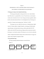
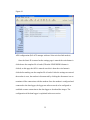
The image processing model can be illustrated as shown in the figure below. The
model identifies several elements or also known as sub systems.
1
Figure-1
Scene
constraints
(light and
optical image)
Image
acquisition
Pre-processing
Segmentation
Actuation
Classification /
Interpretation
Feature
extraction
Image processing model (Ref – G.J. Awcock and R. Thomas)
Scene constraints
The first and most important element is identifying the scene constraint,
the scene refers to the region of interest or the field of view of the image. The aim
of the scene constraint is to reduce the complexity of the model, this is achieved
by making sure the lighting conditions are suitable, the field of view is clear,
lighting being the most important concern.
In an industrial environment the lighting conditions and placement of the
camera are controlled to obtain the best results. In addition to lighting conditions
other factors which might come into effect are dirt, dust and environmental
conditions come into effect while controlling the scene constraint.
Image acquisition
This element in the model is concerned with the process of translation of
light falling on to the camera‟s photo sensors to a stored digital value within the
storage device. A digital image can be of any pixel resolution with each pixel
2
representing a binary, gray scale or a color value. A digital camera uses a CCD
(charged coupled device) to convert light stimuli into a digital value.
Preprocessing
This element seeks to modify and prepare the pixel values of a digital
image to a more suitable image for processing. Generally contrast enhancement
and adjustment, noise reduction and improving the quality of the image is done
during this stage. These operations only change the pixel values of the stored
image and do not make any fundamental changes to the image.
Preprocessing operators act on the spatial domain, this is usually
concerned with a specific pixel value or a small number of neighboring pixels.
Operations which are required to act globally on the image often make use of
transformations. The most commonly used transform is the Fourier transform.
Low level operations generally highlight particular feature of interest. Histogram
manipulations are used to adjust the intensity levels of the image depending on
whether the intensity levels are on the lower or higher side, this usually enhances
or suppress the contrast and stretch or compress the grey levels without any
change in the image data.
Segmentation
This is the initial stage of image recognition process where the acquired
image is broken down into meaningful regions. Segmentation is only concerned
with the process of partitioning the image and not concerned about what the
region represents. In binary images there are only two regions a foreground region
and the background region, in a gray scale image there might be several regions
3
or classes within the image. Image Segmentation consists of two main approaches
namely thresholding and edge based methods.
Thresholding techniques can be employed either on a global or local
methods. In global thresholding the entire image is thresholded with a single
threshold value, whereas in local thresholding technique an image is partitioned
into smaller regions and determines a threshold to these smaller regions.
Edge based segmentation begins with edge enhancement which makes use
of standard finite difference operators, the first order gradient operators, the
second order laplacian operator. The operation enhances intensity changes and
transforms the image into a representation form.
Feature extraction
It is an important function before prerequisite to classification process. In
this process features of different regions within the image are identified. The
characteristics of an image are extracted and obtained such as size, position,
number, area etc.
Classification
The classification process is a successor of feature extraction, it is
concerned with the process of pattern recognition or image classification. It uses
the data extracted from the image to make an accurate decision as to which
category the pattern belongs to.
Actuation
The actuation property provides a means of closing the loop and allowing
interaction with the original data.
4
1.2 Optics.
The digital images are captured by focusing the camera on the object. The
camera is focused using a lens which is used to project the object on to the photo
sensor in the camera. The size and resolution of the sensor will affect the design
of the lens system.
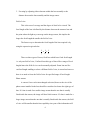
The basic formulae used to calculate the correct focal length to achieve a given
magnification or to predict the effect of change in the focal length are given
below.
Where f is the focal length of the lens, u is the object to lens distance, v is the
image to lens distance, m is the magnification defined as image size is divided by
the object size, n is the numerical aperture or (f number) of the lens and d is the
diameter of the lens aperture.
For designing a suitable lens the following are taken into consideration.
1. Defining the field of view, defining how much of a scene and level of detail
are to be captured.
2. Controlling the amount of light passing through to the image sensor so that
the image is correctly exposed.
5
3. Focusing by adjusting either elements within the lens assembly or the
distance between the lens assembly and the image sensor.
Field of view
This is the area of coverage and the degree of detail to be viewed. The
focal length of the lens is defined by the distance between the entrance lens and
the point where the light rays converge on the image sensor, this implies the
longer the focal length the smaller the field of view.
The fastest way to determine the focal length of the lens required is by
using the expression given below
There are three types of lenses, fixed lens which has a fixed focal length
i.e. only one field of view, Varifocal lens this type of lens offers a range of focal
lengths hence the field of view can be manually adjusted. Zoom lens are like
varifocal length enabling to select a different field of view, in zoom lens however
there is no need to focus the field of view for specified range of focal length.
Photo sensors
A camera‟s lens can be interchanged as desired, however the size of the
photo sensor installed in the lens should be considered to choose the right type of
lens. If a lens is made for a smaller image sensor than the one that is actually
fitted inside the camera, the image will have black corners. If a lens is made for a
larger image sensor than the one that is actually fitted inside the camera, the field
of view will be smaller than the lens capability since part of the information will
6
be “lost” outside the image sensor. A description of the lens size and image
sensor is shown in the figure below.
Figure-2
Lens and mount sensor-(Ref-Axis communication lens elements)
Lens mount and standards
While choosing the lens for the camera the type of mount on the camera
needs to be considered it is a very important factor. There are two main standard
type of lens mounts C-mount and CS-mount for a Closed circuit camera or
network camera. The difference between the two types of lens mounts is.
CS-mount- The distance between the sensor and the lens should be 12.5mm.
C-mount- The distance between the sensor and the lens should be 17.526mm.
A C-mount lens can be used on a CS-mount using a 5 mm spaces known as the
C/CS spacer.
The image quality is determined by the amount of light entering the lens
and exposed onto the photo sensor, this is determined by the f-number of the lens,
the f-number of the lens is determined by the ratio of „focal length to the iris
diameter‟. The equation to calculate the f-number is given below.
7
The smaller the f-number the better the lens‟ light gathering ability i.e. more light
can pass through the lens to the image sensor. In lowlight situations, a smaller fnumber generally produces a better image quality.
1.3 Contrast stretching.
A pixel operation is one in which the output image is a function of the gray
scale values of the pixel at the corresponding position in the input and only of that
pixel. The point (pixel) operation is interpreted using the gray scale histogram.
This histogram represents the frequency of each gray level intensity.
The image brightness is adjusted by observing the histogram of a gray scale
image. If the intensity values are concentrated on end of the range the brightness
of the image can be increased or decreased by adding or subtracting a constant
from all pixel intensity values stored in a array. The brightness modification can
be represented by a simple expression.
Where, P‟ is the pixel value after enhancement.
P is the pixel value before enhancement.
A is the enhancement factor.
The above expression just increases or decreases the brightness of the
image. There is no alteration to the distribution of pixel intensity values in the
histogram hence there is no alteration in the contrast.
8
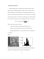
This can be improved by gray level scaling where a multiplication
operation is used for stretch the histogram to cover the complete range of gray
level values. Such scaling factors are constructed in piecewise linear fashion. This
allows a compressed portion of the histogram to be spread out more than sparsely
populated portion of the histogram.
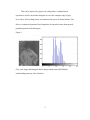
Figure-3
Gray scale image and histogram before image enhancement-(Ref-Matlabunderstanding intensity value function)
9
Figure-4
Gray scale and histogram after histogram equalization (Ref-Matlab-understanding
intensity value function)
It is observed that before intensity adjustment the pixel intensity values were
concentrated at a specific range as shown in the figure, after performing image
enhancement it is visible that the image quality has improved and the pixel
intensity values are not concentrated along a specific range, the pixel intensity
values are spread throughout the entire gray scale range of [0-255], this improves
the image quality.
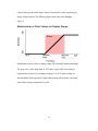
Auto scaling is a special case of contrast enhancement where the pixel
values below a specified value are displayed as black, pixel values above the
specified value is displayed as white and the pixel values in between these two
values are displayed as shades of gray. The result is a linear mapping of a subset
10
of pixel values to the entire range of grays, from black to white, producing an
image of high contrast. The following figure shows this linear mapping.
Figure-5
Relationship of pixel values to display range. (Ref- Matlab-Contrast stretching).
The gray scale values range from [0-255] these values while auto scaling is
represented in a form of a percentage ranging 1% to 99%. Auto scaling as a
function hardly fails to produce a high contrast image which makes extracting
data of these images comparatively easier.
11
1.4 Histogram equalization.
Histogram equalization is a technique used to obtain an optimal contrast
improvement by redistributing the pixel intensity values in order to produce a
uniform histogram. An ideal output image of an histogram should have equal
pixels at every intensity value on the gray scale. For an image with m rows and n
columns using l-bit gray scale resolution, the ideal histogram would be flat with
(m x n/2l) pixels at each gray scale value. Mathematically this can be shown as
(
)
Where, N (g) is the new gray scale value.
C (g) is the cumulative pixel count up to the old gray level,
Round is used to round off the value to the closest integer value.
Histogram equalization is a very powerful tool, but it is not suitable for
every image.
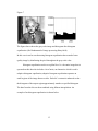
Figure-6
The figure above shows the gray scale image and histogram before histogram
equalization. (Ref-fundamental of image processing-Hany-farid)
12
Figure-7
The figure above shows the gray scale image and histogram after histogram
equalization. (Ref-fundamental of image processing-Hany-farid)
In this case it can be seen that using histogram equalization has created a better
quality image by distributing the pixel throughout the gray scale value.
Histogram equalization works on a global level i.e. the entire image data is
operated on this data also includes a lot of noise, an alternative which is used is
adaptive histogram equalization, adaptive histogram equalization operates on
small regions of the image known as tiles. Each tile‟s contrast is enhanced so that
the histogram of the output region approximately matches a specified histogram.
The data from the tiles are then combined using bilinear interpolation. An
example of an histogram equalization is shown below.
13
Figure-8
Image showing the adaptive histogram equalization-(Ref-Matlab-understanding
intensity value function)
1.5 Remote sensing
Remote sensing was largely used in meteorology or military intelligence
gathering and weather satellite imagery. Satellite imaging is widely used to
monitor environmental data, US LANDSAT program has launched many
satellites for imaging purpose. Applications of remote sensing are very vast.
In meteorology its used in application of short term weather forecasting. The
data obtained from satellites are mainly used for long term weather forecasting
such as global warming etc. Most of the data retrieved concerns the study of
currents in ocean and fluxes of heat and water vapor in the ocean or atmospheric
boundaries. From the data collected it is observed that thermal capacity of the
whole atmosphere is mainly entered over the top five meters of the surface of
water.
14
Image processing for the remote sensing data is performed by assigning a grey
level to a pixel intensity value so that the sensed radiation can be visualized. Raw
data usually in this form will require lot of preprocessing to enhance its
application potential.
NASA‟s earth observation program offers satellite images for environmental
monitoring. NASA offers image analysis software tied up with the Google earth,
the satellite images are full color JPG files offering oceanic, atmospheric, energy,
land and life data.
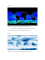
The oceanic data shows the average sea surface temperature, snow cover and sea
ice extent water level radiance etc. Images below show the oceanic image data.
Figure-9
Image shows the average sea temperature data (Ref-NASA-NEO).
15
Figure-10
Image shows the water leaving radiance data (Ref-NASA-NEO).
The atmospheric image data includes cloud fraction, carbon monoxide,
water vapor rainfall etc. some of the image data is shown below.
Figure-11
Image shows the cloud fraction data for a month. (Ref-NASA-NEO).
16
Figure-12
Image shows the water vapor data for a month. (Ref-NASA-NEO).
Figure-13.
Image shows the total rainfall data for a month. (Ref-NASA-NEO)
17
Images above can be interpreted to show climate change, global warming
and other information which helps predicting the weather.
Image processing has a very diverse application ranging from industrial
application to environmental monitoring. The document shows image processing
used in environmental monitoring and medical application involving micro
channels to monitor and observe the flow of fluids.
18
Chapter 2
EXPERIMENTAL SETUP AND PROCEDURE USED FOR IMAGE
PROCESSING IN ENVIRONMENTAL MONITORING.
2.1 Image processing in environmental monitoring.
The image processing done in the project below is on a canal at Indian
bend. Where there is a perennial flow of water. There has been a scale mounted
on the canal to determine the level of water. Image processing is applied to obtain
the above data and monitor the flow of water throughout the day. The images are
captured at 15 minute intervals starting from 7:00 AM to 7:00 PM.
The images in our case which is the data source is obtained using a digital
camera CC640 provided by Campbell Scientific, a data logger CR1000 and the
captured images are being transferred using a cellular modem RAVEN XTG
which works with AT&T network using a high speed data connection to transfer
the images to a work station remotely. The images are received on the workstation
which is configured with advanced image retrieval software known as Logger Net
which is also provided by Campbell scientific.
2.2 Experimental Setup
The image capturing method and transfer is described below.
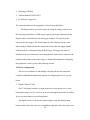
Figure-14
Digital camera
(CC-640)
Datalogger
(CR-1000)
Cellular Modem
(Raven-XTG)
1. Digital camera CC640.
19
Work station
Logger net
Software
2. Data logger CR1000.
3. Cellular Modem RAVEN XTG.
4. PC Software Logger Net.
The connection between the equipment‟s is briefly described below
The digital camera is used to capture the image the image is stored on to
the Data logger which has a 4 MB storage capacity the image captured from the
Digital camera is transferred to the data logger using a CS I/O port from the
camera to the data logger. The stored images are then transferred to the work
station using a cellular modem the connection between the data logger and the
cellular modem is established using the RS232 port. The logger net software
installed on the work station uses an existing internet connection to connect to the
cellular modem and to retrieve the images. A detailed description on configuring
the equipment‟s used is given in the following section.
2.3 Device configuration.
The devices used had to be individually configured before the connection
could be established the detailed description of configuring the device is given
below.
1. Digital Camera CC640.
The CC640 digital camera is a rugged camera as it can operate over a wide
temperature range, it is also very low on power consumption that makes it suitable
for use in remote battery powered operations.
The digital camera can be used to capture images using the installed snap
button on the back of the camera or in standalone operation where the camera can
20
be configured to capture images in specified intervals over a period of time during
the day. In the standalone operation mode the camera wakes itself up from
hibernate mode to capture the image and goes back into hibernation once the
image is captured.
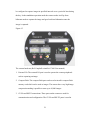
Figure-15.
The camera hardware (Ref-Campbell scientific-CC640 User manual)
1. External I/O: The external I/O port is used to operate the camera peripherals
such as capturing an image.
2. Compact flash: The compact flash port can be used to install a compact flash
memory card which can be used to images. The camera has a very high image
compression making it possible to store up to 10,000 images.
3. CS I/O and RS232 connections: These ports on the camera are used for
communication and configuration. The CS I/O and RS 232 ports is used in
21
combination with a DB9 cable to establish a connection to the computer or the
data logger.
4. Power switch: This switch is used to power the camera continuously on or in
auto power mode. The camera should be place in auto mode when being used
by an external trigger or in self-timed mode, as in auto mode the camera is put
into a low power quiescent mode of operation.
5. Setup button: Pressing the setup bottom performs two functions, firstly it
toggles the video output on or off and secondly the camera‟s RS232 port is
opened for communication with the computer to setup the camera which is
done using the device configuration utility software on the PC.
6. Snap button: This button is used to manually capture the image the camera
needs to be in on position to perform this function.
7. Terminal block connection.
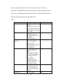
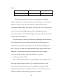
Table-1
Gnd
Power ground
+12VDC
9-15VDC power, 250 mA
Ext
External trigger input, 5.0 Volt
signal.
RS-485A
RS-485 communication
RS-485B
RS-485 communication
Shield
Drain wire
The digital camera‟s settings are configured by connecting it to the
computer using RS232 port on the camera. The settings are edited using the
22
device configuration utility. The camera‟s baud rate is set at 115.2k and a
connection is established between the camera and the computer through the serial
port, the device configuration utility is used to set the clock, PakBus address and
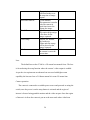
other operating parameters given in the table below.
Table-2
Parameter
PakBus Port
PakBus address
PakBus destination
address
Compression Level
Start minute
Stop minute
Description
None, CS I/O, RS232,
RS 485.
PakBus port Is used for
communication between
the datalogger to transfer
the images
Options 1-4094,
A PakBus address is
assigned to the camera
for PakBus
communications
Option 1-4094.
This is the PakBus
address of the
destination device where
the image files are
transmitted to.
Options: Very high,
high, medium, low,
none.
This option selects the
amount of compression
to be applied to JPG
files. Higher
compression level
implies smaller file size
with loss of subtle
details in the image.
0-1339 minutes.
The option is used in
self-timed mode to set
the start time of image
capture.
0-1440 minutes.
23
Default value
None
55
1
High
0
1440
Self-timed interval
Fixed file name
Time stamp
Clock
The option is used in
self-timed mode to set
the stop time of image
capture.
0-1440 minutes.
0
This parameter is used to
wake the camera in
equal time interval to
capture the image.
On, off.
This option helps assign
a file name for the
images captured.
Options: off, bottom,
Off
top, Inside top.
A date and time stamp
will be placed on the
images captured.
The Date and time on
N/A
the camera is set to the
current time.
Lens
The default lens on the CC640 is a CS mount lens manual focus. The lens
is focused using the setup function where the camera‟s video output is enabled.
As per the site requirements an alternate lens was used with higher zoom
capability the lens used was a 5-100mm manual iris zoom CS mount lens.
Camera operation
The camera is connected to a suitable power source and powered on using the
switch, once the power is on the setup button is activated and the region of
interest is focused using portable monitor and the video out port. Once the region
of interest is in focus the camera is put on to the auto mode where it has been
24
programmed to capture images in self-timed interval. All the captured images are
transferred to the data logger using the CS I/O port.
2. Data logger CR1000.
Introduction.
The data logger used in this project is the Campbell scientific CR1000 data
logger, the function and operations of the CR1000 data logger is very vast it is
used in both analog and digital measurements, it is used in various fields such as
weather monitoring, Image capture and communication, agricultural and
industrial fields.
The data logger is a PakBus Data logger which use back bus communication
to communicate between the camera, other data loggers or the PC. The
configuration of the data logger is described below.
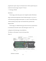
The hardware of data logger is shown in the image below.
Figure-16
Hardware configuration of CR1000 Data logger (Ref-Campbell scientificCR1000 User manual)
25
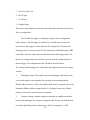
1. Power in/ Power out.
2. RS 232 port.
3. CS I/O port.
4. Peripheral port.
These ports and peripherals are the most important in the operation of the project.
Device configuration:
The CR1000 data logger is configured using the device configuration
utility software. The data logger is connected to a suitable power source and
turned on, the data logger is connected to the PC using the RS 232 port on the
data logger and a serial port on the PC this connection is established using a DB9
serial cable. Once the connections are made between the data logger and the PC
the device configuration utility software is used to enter the settings window of
the data logger. The configuration of the CR1000 is described below.
The settings of the datalogger are edited under the deployment tab on the settings
window,
1.
Datalogger setting: This window shows the datalogger information, such
as the serial number, station number, the operating system running and the
PakBus address which is 1, this is the PakBus address that is assigned same as the
destination PakBus address assigned in the CC640 digital camera, this PakBus
address is where the communications are operated.
2.
Comport Settings: comport settings are assigned to establish connection
between the datalogger, the comport is assigned to RS-232 port, the default baud
rate when establishing a direct connection to the PC is assigned as 115.2K.
26
3.
TCP/IP settings: TCP/IP settings are network protocols which are used to
establish connection between computers or internet devices. The TCP/IP setting
on the CR1000 are as shown below.
IP address- 0.0.0.0
Subnet mask- 255.255.255.0
Default gateway- 0.0.0.0
DNS server1- 0.0.0.0
DNS server2- 0.0.0.0
By assigning all the values to zero, the data logger takes the IP address ass
assigned by the router on the communications modem connected to the
datalogger.
4.
Advanced settings: In this settings window the virtual drive is created on
the datalogger where all the data files are stored, the format of the files saved is
also defined such as JPG or any other desired file format. The settings defined are
shown below.
Is router – No.
SDC Baud rate: 57.6K fixed. This is the baud rate where the images are
transferred to and from the datalogger.
USR Drive size: 259072 bytes. This is the allocated size of the virtual drive where
the images are stored.
27
Table-3
Files manager file name. PakBus Address
Files manager count
USR:test1.jpg
4
55
The files manager is where the directory, file name and the PakBus
address is defined it is as shown in the table above. The images are stored on the
USR drive named as test1 in the JPG format, the image number increase
sequentially, PakBus address is the address where the data is received from in this
case it is 55 which is the PakBus address of the CC640 digital camera. A
maximum of 4 files are saved on the datalogger at one time before it is erased and
overwrite by the new data files.
Once the settings are adjusted it is applied to the datalogger and disconnected.
The configuration is tested by connecting the camera and the datalogger to a
suitable power source and connecting the camera to the CR100 datalogger over
the CS I/O port. The images are captured manually on the digital camera and the
datalogger is connected to the logger net software using a direct comport
connection and the data files saved on the USR drive is verified.
3. Cellular modem Raven XTG
The raven XTG cellular modem is used to establish a connection between the
data logger and the logger net software. The cellular modem works on data
service provided by the wireless service. To establish a connection with the
cellular modem a static IP was assigned to the device. This static IP provides an
address to establish a communication signal over the Static IP.
28
The cellular modem was connected to the CR1000 data logger on the RS 232 port
the connection is shown in the figure below.
Figure-17
Connection between Datalogger and cellular modem-(Ref- Campbell scientificRaven XTG user manual)
The Cellular modem is connected to the power source on the data logger.
The communication between the cellular modem and the CR1000 data logger was
established using a null modem cable this is a 9 pin cable on both the ends and a
directional antenna was connected to the cellular modem to transmit signals. The
cellular modem was configured using the ACE manager software, the
configuration is described below.
29
The cellular modem is powered using a suitable power source, the antenna
is connected. The cellular modem is connected to the PC using the direct RS232
cable. Once the connection is established run the ACE manager software.
On the connect screen the „PPP‟ mode is selected and the appropriate com
port to where the cellular modem is connected. Once the setup mode is entered a
suitable template file for compatible data loggers is loaded. The template file
configures the modem to the Campbell scientific Data logger in this case the
CR1000.
Once the template file is loaded the static IP and APN provided by the
wireless service provider is configured in to the modem. This is done by clicking
on the TCP and EDGE/HSDPA tab on the setup screen. This setup screen is
shown below.
30
Figure-18
Static IP configuration (Ref-ACE manager software Seirra wireless link modem)
31
Figure-19
APN configuration (Ref-ACE manager software Seirra wireless link modem)
Once the Static IP is entered on the settings page is entered the write button is
clicked once the template file is loaded, Then the EDGE/HSDPA button is
clicked, on this page the APN is entered once this is done the write button is
clicked after making sure the template file is loaded. After the settings are entered
the modem is reset, the modem is disconnected by clicking the disconnect icon to
terminate all the connections with the modem. Once the modem is configured and
connected to the data logger, the logger net software needs to be configured to
establish a remote connection to the data logger to download the images. The
configuration of the data logger is explained in the next section.
32
4. Logger Net – Data (image) retrieval software.
The logger net software is used to communicate with the data logger CR1000
over the cellular modem Raven XTG. The Device map is configured using the
setup button on the logger net software. Once the setup mode is entered the
following steps are used to configure the device map.
1. Add root and this select IP port.
2. Add a data logger to the IP port. In this case PakBus datalogger is added since
the CR1000 is a PakBus datalogger.
3. On the IP port page we enter the static IP address and the port number. The
Static IP address and the port number is entered in the following template
“XXX.XXX.XXX.XXX:YYYY‟, where XXX.XXX.XXX.XXX is the static
IP address and “YYYY” is the port number. The extra response time on this
page is set to 4 seconds.
4. The settings on the PakBus port are kept to default.
5. The data logger CR1000 is configured. As described. The PakBus address on
this page is changed to the PakBus address assigned to the datalogger. In this
case the PakBus address is changed to 1.
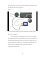
The device map configured is shown in the Image below.
33
Figure-20.
Logger net-IP configuration (Ref-campbell scientific logger net 4.0)
The settings mentioned above will establish a connection with the
Datalogger for setting up Image retrieval the following setting are changed in
logger net under the CR1000 datalogger which are described below. Under the
CR1000 settings there are subcategories.
1. Hardware: In this tab only the Pak bus address of the Data logger is assigned
to 1.
2. Schedule: The data collection schedule of the data logger is configured in this
tab. The schedule collection enabled is checked, The Date and time of the Base
station is set. The collection interval is set as desired in this case it is set to 15
minutes. Primary interval is set in case there is a failure in establishing a connection
with the Datalogger it is set to 2 minutes.
34
3. Image files: In this tab the retrieval mode is set to “follow scheduled data
collection”. In the
file pattern window select add new, this adds a JPG file type. This sets the logger
net to automatically transfer the JPG files on the datalogger. The Output directory
is assigned as desired. This is the directory where all the retrieved images are
going to be stored on the workstation. Once the settings are configured click on
apply and the settings are saved.
4. Image retrieval: The Camera, datalogger and the cellular modem is connected
to a suitable
Power source and the connections are made as described earlier. To retrieve
the images the logger net software is opened and the connect icon is clicked, on
this screen the datalogger to be connected is selected and the connect icon is
clicked. Once the connection is established the images can be retrieved manually
if desired, or the images will be retrieved as per the scheduled program and store
the images in the directory specified. To retrieve images manually the file control
icon is clicked and in this window select the ‟USR‟ drive, this is the virtual drive
created on the CR1000 to store data. The images to be retrieved are selected and
the retrieve icon is clicked once the images are retrieved the window is closed.
The connection to the datalogger is kept active for the software to retrieve images
automatically as per the collection schedule. The images are captured is processed
to determine the level of water in the canal using advanced image processing tools
and software. This is described in the next section.
35
2.4 Experimental Procedure.
The purpose of this project is to obtain the level of water from the image
retrieved by advanced image analysis. The device is configures as described
before. The camera is connected to the datalogger using the CS I/O port and the
cellular modem is connected to the datalogger over the RS232 port. The devices
are connected to a suitable power source. The logger net software is turned and a
connection to datalogger is established over the internet. The images are captured
from 7 AM to 7 PM, with 15 minute interval. All the image data is stored is the
specified directory. The images are now analyzed and processed.
The Images are captured in full color, the resolution of the image
640X504. An image retrieved is shown below.
Figure-21
The scale on the image is of 2 ft. The scale is used as a comparison for the level of
water to the level of water obtained by using image processing on the software.
36
The images retrieved are processed using MATLAB software, MATLAB
has many advanced image processing tools. The detailed analysis used for
obtaining the result is described below.
The image is initially read to the MATLAB software in this stage the
image data is a full color RGB format. The image is then converted to a gray scale
image. Doing this reduces the noise in the image and simplifies the process of
analyzing the image. Once the image is converted to gray scale we have intensity
range varying from only 0 to 255. The gray scale image is as shown below.
Figure-22
Once the image is converted to gray scale the region of interest is selected using
the „imtool‟ function in MATLAB. As the image contains lot of unwanted data
37
the image is cropped to the region of interest i.e. around the scale on the image.
The pixels are chosen suitable to crop the image. The „imcrop‟ function in
MATLAB is used to perform this. The format of imcrop goes as specified ”
imcrop(I, [xmin ymin width height])” , the xmin and ymin are defined using the
spatial coordinates on the image. The xmin is the low coordinate on the x
direction or the horizontal axis and ymin is the lower coordinate value on the y
axis or the vertical axis, the width and the height are the dimensions of the
rectangle, this defines the crop dimensions on the image. The cropped image is as
shown below.
Figure-23
The crop is chosen such that ymin coincides on the 2ft marking on the
scale, this makes the two feet mark as the 1st pixel. The dimensions of the
rectangle are [110width x 214height]. Since the camera is fixed in a location the
coordinates or dimension of the crop do not change. If the camera is shifted from
38
the original position the properties such as the xmin, ymin, width and height of
the rectangle are reset using the imtool function.
The cropped image is now the data where the level of water is determined
from. Since the image data is in gray scale each pixel intensity value varies from 0
to 255, these intensity values are used to plot an intensity profile along a specified
vector from the first pixel on the image to the last pixel on the image height wise.
The pixel intensity profile along a vector defined along the scale is as
observed in the image below.
Figure-24.
Pixel intensity profile of gray scale image.
As observed in the image the horizontal axis of the image represents the
water level in feet, the pixel intensity is plotted for data between 0 to 1 ft. on the
scale of the image for simplicity of the plot. The vertical axis represents the Pixel
intensity value which varies from 0 to 255. The plot reveals that the intensity of
39
the water and the background scale does not mark an evident difference. The
intensity plot represents a lot of noise. This noise or fluctuation in the pixel
intensity values are reduced by adjusting the contrast of the image, this is done by
using contrast stretching property.
The contrast of the image is adjusted using the “imadjust” function in
MATLAB. The format of the imadjust tool is
K = imadjust(I,[Low in; High in],[low out; high out]);
K is the output image after the contrast has been adjusted.
Imadjust is the function that varies the contrast.
I – this is the Image data for which the contrast has to be altered. In this case it is
the cropped gray scale image.
[Low in; High in]- These are the low and high input intensity values to be entered,
these values ranges from 0 to 1.
[Low out; High out]- These are the output intensity values to be entered, these
values ranges from 0 to 1. The low out and high out values does not imply to this
particular case as the image data is gray scale image, hence these values are left
blank.
The image after applying the contrast adjust function is as shown below.
40
Figure-25
The function used in MATLAB for the gray scale image will be.
K = imadjust(I,[Low in; High in],[]);
Initially the Low in and High in values were entered in manually using
trial and error method. For the values to be chosen automatically a Curve fit
model was used. The parameter used in the curve fit model is the Mean and
Variance of the pixel intensity values. The image statistics such as the mean and
variance of the pixel intensity values are obtained by analyzing the histogram of
the gray scale image. The mean and variance of the gray scale images vary
throughout the day, during the day time the mean and variance are found to be
higher than the mean and variance observed later point of the day. The change is
observed as the sun light is directly incident on the region of interest during the
day and as the day progress the sunlight falls behind the scale creating a shadow
41
on the scale this reduces the mean and variance of the gray scale image.
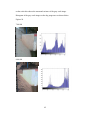
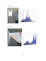
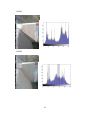
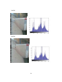
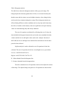
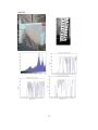
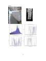
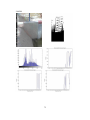
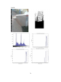
Histogram of the gray scale images as the day progresses are shown below.
Figiure-26
7:00 AM
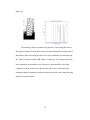
8:00 AM
42
9:00 AM
10:00 AM
43
11:00 AM
12:00 PM
44
1:00 PM.
2:00 PM
45
3:00 PM
4:00 PM
46
5:00 PM.
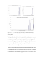
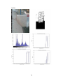
The above figure shows the images throughout the day and the histogram for the
region of interest in gray scale. The mean and the variance for the day are
tabulated below.
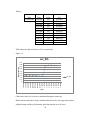
Table-4
Date
Nov_3rd
Time
7:00 AM
Mean
Standard
Deviation
Variance
142.6401 70.437961 4961.506
8:00 AM 187.87551 62.549844 3912.483
9:00 AM
210.1801 56.637144 3207.766
10:00 AM 135.65305 49.499134 2450.164
11:00 AM 103.92973 41.432857 1716.682
12:00 PM 174.42577 66.147232 4375.456
1:00 PM 147.29126 73.122588 5346.913
2:00 PM 130.37486 50.438268 2544.019
3:00 PM
134.4665 57.281009 3281.114
4:00 PM 135.62627 54.449669 2964.766
5:00 PM 132.46231 58.379753 3408.196
47
Table: Histogram statistics.
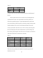
The table above shows the histogram statistics of the gray scale image, The
histogram plots the intensity against the no of bins, it is relevant from the plots
that the mean and the variance are on the higher intensity values during the day
and is on the lower intensity during the evening. There histogram statistics are
affected during different weather conditions such as rainy days and cloudy days,
the effect of weather on the intensity values are significant as the pixel intensity
values are reduced during rainy and cloudy conditions.
The curve fit equation was obtained by collecting data over 10 days, the
data included the histogram characteristics such as the mean, standard deviation ,
variance and the low in and high in values used in the „imadjust‟ function of
MATLAB, the low in and high in are obtained from trial and error for the entire
period of data collected.
Algebra analysis is used to obtain the curve fit equations for the data
collected. The curve fit equations for the low in and high in are as given below.
Low in = 0.003589*B-4.022e-6*V;
High in =0.004327436*B+7.04752e-9*V
B – Mean obtained from the histogram data
V- Variance obtained from the histogram data.
The above mentioned curve fit equations can be used to adjust the contrast
of the image. The adjusted image using the curve fit equations are shown below.
48
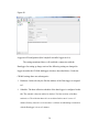
Figure-27
7:00 AM
9:00 am
10:00 AM
49
1:00 PM
4:00 pm
The images show the contrast adjustments between the raw gray image and the
contrast adjusted images. As it is clearly visible the level of water on the scale is
very distinct, the background i.e. the scale is white and the water is black, this
gives a very clear marking of where the level of the water is in comparison to the
scale. Plotting the intensity profile of the image will clearly show the transition
from water to the scale. The pixel intensity plot for the contrast adjusted image is
as shown below.
50
Figure-28
The intensity values are plotted using specific vectors along the scale in
the region of interest. The intensity values are plotted from the top of the scale to
the bottom of the scale along the scale, the vector coordinates are selected using
the „imtool‟ function in MATLAB. There are some gray scale images with some
noise around the water and the scale, this noise is generated due to the light
conditions, at noon as the suns is directly above the water, it turns the water
transparent hence adjusting the contrast would create some noise, image showing
the noise are shown below.
51
Figure-29
Noisy image data captured at 1:15 pm.
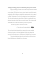
As it is observed in the contrast adjusted image there is a lot of noise, hence to get
an accurate result of water level, three vector coordinates are defined along the
scale to obtain the level of water and the average of the water level is taken.
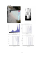
Figure-30
52
Fig: 1, 2, 3, 4, 5, 6- Raw image, gray scale image, Contrast adjusted image,
Intensity plots.
The images above show the level of water plotted after the adjusting the contrast
on the gray scale image. The raw image is cropped and converted to gray scale,
the contrast of the gray scale image is adjusted using the „imadjust‟ function once
the contrast is adjusted pixel intensity values are plotted along the three vector
coordinates this shown in the figures above.
The level of water is determined by analyzing the intensity plots, the logic applied
in determining the water level from intensity plots goes as described, an equation
is generated which counts the number of pixels which are of zero intensity if there
53
are 10 pixels or more of zero intensity in a sequence the first non-zero pixel
before the zero is selected as the pixel where the level of water stands, since the
pixel count is known the length of the scale is known which is 2 feet and the
number of pixels taken for 2 feet is known, thus a conversion is made between the
number of pixels and the length of the scale, 2 feet is equivalent 213 pixels, thus
the length of 1 pixel is determined. This unit is used for the pixel number
determined by the Level equation and the number of pixels with non-zero
intensity values is converted to the level of water.
The images captured and retrieved from the canal are analyzed using
MATLAB the results are tabulated and discussed in section 4.1.
54
Chapter 3
EXPERIMENTAL PROCEDURE AND SETUP USED FOR HIGH SPEED
IMAGING ANALYSIS
3.1 High speed image analysis of fluid in a micro channel
This section describes the experimental procedure and results of high
speed imaging and analysis of fluid flowing in micro channels. There were
different kinds of presses used to manufacture the micro channels those include
Ballistic press, hydraulic press, Laser press, Rotary and Stamped press, all these
presses were tested with water based dye and whole milk to analyze the flow
duration and flow pattern in the micro channel. The experimental setup and
procedure is described in the next section.
3.2 Experimental setup
High speed digital camera is used to capture the video of the fluid flowing
through the micro channel, the high speed digital camera is a Casio-Exilim FH25,
this camera shoots high speed video at 1000 frames per second. The camera has
different settings to capture images at different speeds 240fps, 420fps and 1000
fps. This experiment is conducted with videos being recorded at 420fps. The
resolution of the video (224x168) shot at 420fps. There are two types of presses
which are used in this experiment one is a single channel press and the other is a 3
channel press, the image of the channels are as shown in the images below.
55
Figure-31
C
B
A
Fig: Single channel and 3 channel press representation.
56
The single channel press is of the rotary and stamped press, the flow duration is
monitored for the entire channel (A-C) and the duration of flow for the reservoir
(B-C),
The experiment is also conducted by exposing the channel to a beam of
laser and projecting on to a screen. A high power laser is used to project the
channel onto the screen. The 30 W laser is pointed at a mirror which reflects the
beam on to the channel placed on a mounting plate the beam is then projected on
to the screen using a triangular prism. The experimental setup is as shown in the
image below.
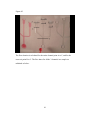
Figure-32
Experimental setup for laser projection of samples. Image constructed in
AUTOCAD-3d.
57
The channel is projected on the screen to observe and analyze the defect of fluid
flowing in the channel.
3.3 Experimental procedure
The sample press is placed on a white or red board to create a suitable
from the water based red dye or with milk respectively. The camera is focused on
to the channel it is made sure that there is channel is illuminated substantially.
The dye or milk is introduced into the channel using a pipette.
The flow is observed for any defects and the duration of flow is recorded. The
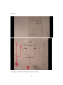
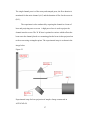
images of channels with water based dye and whole milk is shown below
Figure-33
Shows a ballistic three channel with water based dye as the fluid. Images show
before the fluid was introduced into the channel and after the flow is completed in
the channel.
58
Figure-34
Fig: Shows a ballistic press three channel with whole milk as the fluid. Images
show before the fluid was introduced into the channel and after the flow is
completed in the channel.
Figure-35
Fig: Rotary press single channel, with water based dye as fluid.
Figure-36
59
Fig: Rotary press single channel, with whole milk as fluid.
The experiment with water based dye as fluid is repeated for all the channels of
Ballistic press, Hydraulic press and the Laser press. 30 samples of each of the
types of presses are analyzed for the duration of flow for the entire channel (A-C)
and the duration of flow for the reservoir (B-C). The results are tabulates and the
Avergae, standard deviation and variance of the flow time are calcualted and
discussed in the results section.
The experimental procedure for channels projected using laser beam is
described below. The high power laser is connected to a power source and
switched on, the set of channels is kept on the mounting plate. The lights in the
Laboratory are turned off to create a better quality projection. The image
projected is adjusted and focussed on the screen. Once the image is focussed the
fluid is introduced into the channel using a pipette. The flow of fluid through the
channel is monitor, since the field of view on the projected image is very small
only a part of the channel is viewed. The reservoir of the channel is focussed and
viewwd for defects during the flow. The fluid used in the micro channel was
whole milk as the milk is viscous in comparison to a water based dye, this helps
in analyzing the defects. The experiment is repeated with all the sets, Ballistic
press, Hydraulic press and Laser press. The projected images of the channels are
as shown below.
60
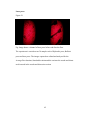
Ballistic press
Figure-37
Fig: Image shows a channel of ballistic press before and after the flow.
Hydraulic press
Figure-38
Fig: Image shows a channel of hydraulic press before and after the flow.
61
Laser press
Figure-39
Fig: Image shows a channel of laser press before and after the flow.
The experiment is carried out on 30 samples each of Hydraulic press, Ballistic
press and laser press. The images captured are editted and analyzed for the
Average flow duration, Standard deviation and the variance the results and charts
are discussed in the results and discussion section.
62
Chapter 4
RESULTS AND DISCUSSION.
4.1 Image processing and analysis of water flowing through the canal.
The images of water flowing through a canal is captured using a digital
camera, these images are stored in a datalogger, the images are retreived using a
cellular modem which is connected to the datalogger. The images are retreived
using logger net software which establishes a connection between the datalogger
and the workstation using an active internet connection to connect to the cellular
modem.
The images retreived are process in matlab using advancced image
processing functions to determine the level of water. The images are converted to
gray scale, cropped and the contrast of the images are adjusted to determine the
level of water. The contrast is adjusted using curve fitting technique. The
equations used for determining the low and high intensity values are given below.
Low in = 0.003589*B-4.022e-6*V;
High in =0.004327436*B+7.04752e-9*V
Where B and V are the mean and the variance of the grayscale image determined
from the histogram data.
The equations for low and high intensity values are determined using
curve fitting technique is described below. The equations can be represented in
the form of
Ax=b
63
Where A is a matrix of the mean and variance of the intensity values. The matris
is of a 2xn Dimension.
The matrix b is the intensity low and high input intensity values determined from
trial and error. Let b-low and b-high be the low and high intensity input values in
the matlab function imadjust.
We have x is te low in and high in intensity input values to be used in matlab
using the curve fitting techinique.
The matrices used are shown below.
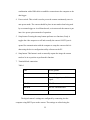
Table-5
Matrix A
Mean
Variance
190.1634 3085.756
106.4162 1777.98
172.9345 4415.085
126.0862 2421.341
132.5402 2845.483
137.2556 2871.097
134.1966 3616.998
149.9577 4556.185
185.2259 3516.141
207.9857 3006.383
129.7425 2352.962
108.9915 1875.477
176.7056 4226.065
127.0046 2265.784
135.5462 3082.734
136.822 2930.628
134.9555 3287.82
146.7874 4709.853
184.0917 3730.044
205.948 3232.667
134.5122 2777.735
102.6394 1763.076
Matrix b-low and bhigh
b-low
b-high
0.65
0.8
0.4
0.5
0.65
0.75
0.45
0.6
0.45
0.6
0.45
0.6
0.45
0.6
0.5
0.6
0.65
0.8
0.75
0.85
0.45
0.6
0.4
0.5
0.65
0.75
0.45
0.6
0.45
0.6
0.45
0.6
0.45
0.6
0.5
0.6
0.65
0.8
0.75
0.85
0.45
0.6
0.35
0.45
64
173.5063
125.7195
132.3237
130.6944
147.6466
184.8094
209.9589
135.0568
103.0763
173.806
153.1523
126.4598
136.6129
134.5188
133.2045
147.0159
186.0779
211.8446
132.3902
102.3533
175.6141
155.3056
124.6545
134.5669
134.1671
132.2553
142.6401
187.8755
210.1801
135.653
103.9297
174.4258
147.2913
130.3749
134.4665
135.6263
132.4623
4340.756
2351.17
3164.259
3186.248
4781.136
3730.544
3231.378
2709.347
1698.714
4339.71
4775.175
2388.548
3590.803
3112.905
3907.06
4767.832
3633.794
3057.731
2446.776
1657.754
4452.666
4963.455
2242.399
3129.659
2834.56
3223.271
4961.506
3912.483
3207.766
2450.164
1716.682
4375.456
5346.913
2544.019
3281.114
2964.766
3408.196
0.65
0.45
0.45
0.45
0.5
0.65
0.75
0.45
0.35
0.65
0.55
0.45
0.45
0.45
0.45
0.5
0.65
0.75
0.45
0.35
0.65
0.6
0.45
0.45
0.45
0.45
0.45
0.65
0.75
0.45
0.35
0.65
0.5
0.45
0.45
0.45
0.45
65
0.75
0.6
0.6
0.6
0.6
0.8
0.85
0.6
0.45
0.75
0.65
0.6
0.6
0.6
0.6
0.6
0.8
0.85
0.6
0.45
0.75
0.7
0.55
0.6
0.6
0.6
0.6
0.8
0.85
0.6
0.45
0.75
0.6
0.6
0.6
0.6
0.6
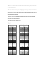
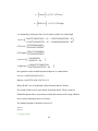
x=(
x=(
) = (ATA)-1 (ATb-low)
) = (ATA)-1 (ATb-high)
x is obtained by solving the above set of matrices with b-low and b-high
+
(ATA)-1=*
(ATb-low)=
(ATb-high)=
x=(low in)=(
)
)
x=(high in)=(
the equations used in matlab function imadjust is as written below.
Low in = 0.003589*B-4.022e-6*V;
High in =0.004327436*B+7.04752e-9*V
Where B and V are as mentioned earlier the mean and the variance.
The results of the level of water shown in the table below. These results are
obtained using the above expressions to adjust the contrast of the image which in
turn is used to determine the level of water.
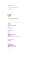
The matlab program to obtain the water level.
close all;
clear all;
% reading an image
66
I=imread('test15660.jpg');
%converting an image to gray scale
Im=rgb2gray(I);
figure, imshow(Im);
% crop the region of Interest.
I1 = imcrop(Im,[370 333 110 214]);
% MEAN AND STANDARD DEVIATION
B=mean2(I1);
b=std2(I1);
V=b^2;
%Adjusting the Contrast of the image.
C1=0.003589*B-4.022e-6*V;
C2=0.004327436*B+7.04752e-9*V;
P=imadjust(I1,[C1 C2],[]);
%Defining the Co-ordinates for Pixel to Feet Conversion.
A=[1:213'];
for i=1:213;
n(i)=(214-A(i))*0.00939;
end
% Intensity profile-1
x1=[33 80];
y1=[1 213];
c=improfile(P,x1,y1);
figure()
plot(n,c);
axis([0 1.0 0 300]);
set(gca,'XTick',0:0.05:1.0)
xlabel('Water level in Feet')
ylabel('Intensity')
title('Intensity profile of processed image-1')
% Intensity profile-2
x2=[53 65];
y2=[1 213];
c2=improfile(P,x2,y2);
figure()
plot(n,c2);
axis([0 1.0 0 300]);
set(gca,'XTick',0:0.05:1.0)
xlabel('Water level in Feet')
ylabel('Intensity')
title('Intensity profile of processed image-2')
% Intensity profile-3
x3=[83 70];
y3=[1 213];
67
c3=improfile(P,x3,y3);
figure()
plot(n,c3);
axis([0 1.0 0 300]);
set(gca,'XTick',0:0.05:1.0);
xlabel('Water level in Feet')
ylabel('Intensity')
title('Intensity profile of processed image-3')
figure, imshow(P)
% Calculating the Level of water from the intensity plot-1
check=0;
for N=1:203
if (c2(N)==0 && c2(N+1)==0 && c2(N+2)==0 && c2(N+3)==0 && c2(N+4)==0 &&
c2(N+5)==0 && c2(N+6)==0 && c2(N+7)==0 && c2(N+8)==0 && c2(N+9)==0 &&
c2(N+10)==0 && check==0)
level1=N;
check=1;
end
end
% Calculating the Level of water from the intensity plot-2
check=0;
for N=1:203
if (c(N)==0 && c(N+1)==0 && c(N+2)==0 && c(N+3)==0 && c(N+4)==0 && c(N+5)==0
&& c(N+6)==0 && c(N+7)==0 && c(N+8)==0 && c(N+9)==0 && c(N+10)==0 && check==0)
level2=N;
check=1;
end
end
% Calculating the Level of water from the intensity plot-3
check=0;
for N=1:203
if (c3(N)==0 && c3(N+1)==0 && c3(N+2)==0 && c3(N+3)==0 && c3(N+4)==0 &&
c3(N+5)==0 && c3(N+6)==0 && c3(N+7)==0 && c3(N+8)==0 && c3(N+9)==0 &&
c3(N+10)==0 && check==0)
level3=N;
check=1;
end
end
% Actual height of water from processed Image
Height1=(213-level1)*0.00939;
Height2=(213-level2)*0.00939;
Height3=(213-level3)*0.00939;
% Average taken to determine the level of water.
waterlevel=(Height1+Height2+Height3)/3;
Data shows the images retrieved and processed for October 9th obtained using the
Matlab code.
68
Figure-40.
7:00 AM
69
8:00 AM
70
9:00 AM
71
11:00 AM
72
12:00 PM
73
1:00 PM
74
2:00 PM
75
3:00 PM
76
4:00 PM
77
5:00 PM
78
Table-6
Date
October 9th
Pixel
Value
181
182
182
182
182
183
183
130
128
128
129
Time
7:00 AM
8:00 AM
9:00 AM
10:00 AM
11:00 AM
12:00 PM
1:00 PM
2:00 PM
3:00 PM
4:00 PM
5:00 PM
Water Level
(ft.)
0.303485
0.294095
0.294095
0.294095
0.294095
0.284705
0.284705
0.782375
0.801155
0.801155
0.791765
Table shows the data of water level for an entire day.
Figure- 41
0.9
0.8
0.7
0.6
0.5
0.4
0.3
0.2
0.1
0
7:00 PM
6:15 PM
5:30 PM
4:45 PM
4:00 PM
3:15 PM
2:30 PM
1:45 PM
1:00 PM
12:15 PM
11:30 AM
10:45 AM
10:00 AM
9:15 AM
8:30 AM
7:45 AM
oct_9th
7:00 AM
Water level (ft)
oct_9th
Time
Chart shows the level of water as monitored during the entire day.
Data has been archived for many months which shows the raw image and contrast
adjusted image and the pixel intensity plots showing the level of water.
79
4.2 High speed imaging analysis of a fluid flowing through a micro channel.
High speed imaging is carried out to be able to analyze the flow of fluid in
a micro channel. The fluid travels across a micro channel ver quickly this makes
analzying the fluid a challenge, to simplify this experiment the video is captured
at 420fps. The duration of flow for all the channels are observed and tabulated.
The videos while analyzed are played back at 29fps this is considerably slower
than actual time taken for the fluid to traverse the channel. The real time needed
for the fluid to flow in the micro channel is given by the expression.
The results are tabulated using the above expression the average, standard
deviation and variance is calculated and plotted for the entire channel and
reservoir for all the three press i.e. Ballistic press, Hydraulic Press, Laser press.
The results tabulated and charts for water based dye as fluid are shown
below for Ballistic press, Hydraulic Press, Laser press.
80
Figure-42
The flow duration is calculated for the entire channel point A to C, and for the
reservoir point B to C. The flow times for all the 3 channels in a sample are
tabulated as below.
81
Table-7
Ballisitc Press.
Mean
Standard
deviation
Variance
Flow time for Ballistic Press
Left channel
Center Channel
(Inclined)
Reservoir Channel Reservoir Channel
B-C (s)
A-C (s) B-C (s)
A-C (s)
1.262
2.357
1.275
2.461
0.029
0.036
0.027
0.040
Right Channel
(Perpendicular)
Reservoir Channel
B-C (s)
A-C (s)
1.320
2.805
0.040
0.039
0.001
0.002
0.001
0.001
0.002
0.002
Table-8.
Hydraulic Press
Mean
Standard
deviation
Variance
Flow time for Hydraulic Press
Left channel
Center Channel
(Inclined)
Reservoir Channel Reservoir Channel
B-C (s)
A-C (s) B-C (s)
A-C (s)
1.247
2.361
1.247
2.455
0.076
0.068
0.051
0.061
Right Channel
(Perpendicular)
Reservoir Channel
B-C (s)
A-C (s)
1.298
2.825
0.041
0.063
0.006
0.002
0.005
0.003
0.004
0.004
Table-9
Laser Press
Mean
Standard
deviation
Variance
Flow time for Laser Press
Left channel
Center Channel
(Inclined)
Reservoir Channel Reservoir Channel
B-C (sec) A-C
B-C (sec) A-C
(sec)
(sec)
1.201
2.337
1.227
2.442
0.035
0.041
0.056
0.098
Right Channel
(Perpendicular)
Reservoir Channel
B-C (sec) A-C
(sec)
1.241
2.772
0.027
0.025
0.001
0.001
0.002
0.003
82
0.010
0.001
The charts for the above data are shown below.
Figure-43
mean_B-C_flow times(reservoir)
1.340
1.320
Time_(sec)
1.300
1.280
mean(B_C)flow_left
1.260
Mean(B_C)flow_center
1.240
Mean(B_C)flow_right
1.220
1.200
1.180
0
1
2
3
4
Axis Title
StdDev(B-C)flowtime_(reservoir)
0.080
0.070
Time_(Sec)
0.060
0.050
0.040
StdDev(B-C)_left
0.030
StdDev(B-C)_center
0.020
StdDev(B-C)_right
0.010
0.000
0
1
2
3
Axis Title
83
4
Variance(B-C)flowtime_(reservoir)
0.007
0.006
Time_(sec)
0.005
0.004
Var(b-c)_left
0.003
var(b-c)_center
Var(b-c)_right
0.002
0.001
0.000
0
1
2
3
4
Axis Title
The Charts above show the mean, standard deviationand variance of flow duraion
of the reservoir for water based dye as fluid.
84
mean(a-c)flowtime
3.000
2.500
Time_(sec)
2.000
mean(a-c)_left
1.500
mean(a-c)_center
1.000
mean(a-c)_right
0.500
0.000
0
1
2
3
4
Axis Title
Std_dev(a-c)flowtime
0.120
0.100
Time(sec)
0.080
StdDev(a-c)_left
0.060
StdDev(a-c)_center
0.040
StdDev(a-c)_right
0.020
0.000
0
1
2
3
Axis Title
85
4
Var(a-c)Flowtime
X-axis
1. Hydraulic
press
2. Laser Press
0.010
0.009
0.008
Time(sec)
0.007
0.006
0.005
Var(a-c)_left
0.004
Var(a-c)_center
Var(a-c)_right
0.003
0.002
0.001
0.000
0
1
2
3
4
Axis Title
The charts above show the Mean, standard deviation and variance of flow
durations for the entire channel for water based dye as the fluid. The data points
1,2,3 on the x-axis represents the
For the single channel rotary press using water based dye as the fluid the
data is collected in the similar manner as the 3 channel sample. The mean,
standard deviation and variance of flow duration is calculated in real time. The
duration of flow is calculated for the entire channel(A-C) and for the reservoir(BC).
86
Figure-44
C
B
A
Single channel data points for a dye
The results for the rotary press using water based dye as a fluid is tabulated
below.
Table-10
Mean
Standard
Deviation
Variance
Reservoir
(B-C) sec
0.931069
Entire channel
(A-C) Sec
2.108331
0.026617
0.000708
0.057937
0.003357
The expirement was initially conducted using water based dye, the
viscosity of water being very less the fluid would travel throught the channel very
quickly, using a much more viscous fluid such as whole millk would slower the
fluid flowing through the channel and helps in analyzing the flow pattern or
observe any defects in the press. The experiment was conducted in similar manner
as the 3 channel press and the single channel rotary and stamped press. Fluid was
87
introduced into the channel and the flow duration was observed and tabulated for
the entire channel (A-C) and for the reservoir (B-C)
Figure-45
A
B
B
C
C
All the data including the defects are tabulated and shown below.
Table-11
Laser Press
Mean
Standard
deviation
Variance
Flow time for Laser Press
Right channel
Center Channel
(Inclined)
Reservoir Channel Reservoir Channel
B-C (s)
A-C (s) B-C (s)
A-C (s)
2.9766
5.8037
2.8606
5.8759
0.2518
0.2519
0.0764
0.1241
Left Channel
(Perpendicular)
Reservoir Channel
B-C (s)
A-C (s)
2.8474
6.7780
0.0892
0.1183
0.9181
0.1152
0.9192
0.0912
88
0.2229
0.2026
Table-12.
Hydraulic Press
Mean
Standard
deviation
Variance
Flow time for Hydraulic Press
Right channel
Center Channel
(Inclined)
Reservoir Channel Reservoir Channel
B-C (s)
A-C (s) B-C (s)
A-C (s)
2.9425
5.5884
2.9610
5.8085
0.1301
0.2451
0.1833
0.4868
0.1189
0.2047
0.1982
0.5691
Left Channel
(Perpendicular)
Reservoir Channel
B-C (s)
A-C (s)
2.9809
6.6430
0.1222
0.2162
0.2225
0.7169
Table-13.
Ballistic Press
Mean
Standard
deviation
Variance
Flow time for Ballistic Press
Right channel
Center Channel
(Inclined)
Reservoir Channel Reservoir Channel
B-C (s)
A-C (s) B-C (s)
A-C (s)
2.9620
5.8133
2.9944
6.0900
0.0875
0.1110
0.6373
5.8817
0.0804
0.0936
0.6212
5.5894
Left Channel
(Perpendicular)
Reservoir Channel
B-C (s)
A-C (s)
3.0010
6.9216
0.1114
0.1797
0.6275
5.7023
The charts for the above data using whole milk as a fluid is plotted below. The
plots show the flow durations for reservoir and the entire 3 channel sample.
89
Figure-46
Time (sec)
Mean_reservoir
3.0200
3.0000
2.9800
2.9600
2.9400
2.9200
2.9000
2.8800
2.8600
2.8400
2.8200
X-Axis
1. Laser Press
2. Hydraulic
Press
3. Ballistic press
Mean_rightchannel
Mean_centerchannel
Mean_leftchannel
0
1
2
3
4
Axis Title
Standard deviation_reservoir
X-Axis
1. Laser Press
2. Hydraulic
Press
3. Ballistic
press
0.3000
0.2500
Time(sec)
0.2000
Stddev_rightchannel
0.1500
Stddev_centerchannel
0.1000
StdDev_leftchannel
0.0500
0.0000
0
1
2
3
Axis Title
90
4
Variance_ reservoir
0.6000
X-Axis
1. Laser Press
2. Hydraulic
Press
3. Ballistic
press
0.5000
Var_rightchannel
0.4000
var_centerchannel
0.3000
Var_leftchannel
1.0000
0.9000
0.8000
Time(sec)
0.7000
0.2000
0.1000
0.0000
0
1
2
3
4
Axis Title
The Plots above show the mean, standard deviation and variance of flow duration
for the reservoir for which the fluid used is whole milk.
mean_entire channel
5.0000
X-Axis
1. Laser Press
2. Hydraulic
Press
3. Ballistic
press
4.0000
Mean_rightChannel
3.0000
Mean_centerchannel
8.0000
7.0000
Time(sec)
6.0000
Mean_leftchannel
2.0000
1.0000
0.0000
0
1
2
3
Type Of press
91
4
Standard_deviation_entire channel
0.7000
X-Axis
1. Laser Press
2. Hydraulic
Press
3. Ballistic
press
Stddev_rightchannel
0.6000
Time(sec)
0.5000
0.4000
0.3000
Stddev_centerchannel
0.2000
StdDev_leftchannel
0.1000
0.0000
0
1
2
3
4
Axis Title
Variance_entire channel
7.0000
X-Axis
1. Laser Press
2. Hydraulic
Press
3. Ballistic
press
6.0000
Time(sec)
5.0000
4.0000
Var_rightchannel
3.0000
Var_centerchannel
Var_leftchannel
2.0000
1.0000
0.0000
0
1
2
3
4
Axis Title
The Plots above show the mean, standard deviation and variance of flow duration
for the entire channel for which the fluid used is whole milk.
92
It is observed that the data collected with milk had defects which effected the over
all flow duration of the fluid. These defects are observed vary from a minimal
flow deformation to a more prominent damage in the press. The data collected
with milk was observed to have many number of these defects the data was
revised by removing the defective samples from the initial data set. The revised
data set is as tabulated below.
Table-14
Ballistic Press
Mean
Standard
deviation
Variance
Flow time for Ballistic Press
Right channel
Center Channel
(Inclined)
Reservoir Channel Reservoir Channel
B-C (s)
A-C (s)
B-C (s)
A-C (s)
2.960934 5.695125 2.993574 5.938512
0.084538 0.145672
0.103516 0.307364
Left Channel
(Perpendicular)
Reservoir Channel
B-C (s)
A-C (s)
2.999941 6.720324
0.081769 0.151461
0.096845 0.332279
0.10522 0.150361
0.16036 0.327468
Flow time for Hydraulic Press
Right channel
Center Channel
(Inclined)
Reservoir Channel Reservoir Channel
B-C (s)
A-C (s)
B-C (s)
A-C (s)
2.952687 5.611725 2.968797 5.797126
Left Channel
(Perpendicular)
Reservoir Channel
B-C (s)
A-C (s)
2.991542 6.620936
0.125311 0.154939
0.227445 0.347711
0.115744 0.149206
0.194042 0.322458
Table-15.
Hydraulic Press
Mean
Standard
deviation
Variance
0.116794 0.140495
0.19758 0.285903
93
Table-16
Laser Press
Mean
Standard
deviation
Variance
Flow time for Laser Press
Right channel
Center Channel
(Inclined)
Reservoir Channel Reservoir Channel
B-C (s)
A-C (s)
B-C (s)
A-C (s)
2.899948 5.729054 2.873828 5.892449
Left Channel
(Perpendicular)
Reservoir Channel
B-C (s)
A-C (s)
2.838886 6.769372
0.09545 0.105144
0.131963 0.160128
0.090409 0.103712
0.118393 0.155797
0.070181 0.110652
0.07134 0.177346
Figure-47
Mean_reservoir_No_defect
3.02
X-axis
1. Ballistic press.
2. Hydraulic press.
3. Laser press.
3
2.98
Axis Title
2.96
2.94
Mean_right_ad
2.92
2.9
mean_center_ad
2.88
Mean_leftch_ad
2.86
2.84
2.82
0
1
2
3
Axis Title
94
4
Standard deviation_reservoir_No_defect
0.14
X-axis
1. Ballistic press.
2. Hydraulic press.
3. Laser press.
0.12
Time (sec)
0.1
0.08
StdDev_rightchannel_afte
rDef
0.06
Stddev_centerch_AD
Stddev_leftch_AD
0.04
0.02
0
0
1
2
3
4
Axis Title
Variance_reservoir_No_defects
0.25
X-axis
1. Ballistic
press.
2. Hydraulic
press.
3. Laser press.
Time (sec)
0.2
0.15
VAR_rightch_AD
VAR_centerCh_AD
0.1
VAR_leftch_AD
0.05
0
0
1
2
3
Axis Title
95
4
The Plots above show the mean, standard deviation and variance of flow duration
for the reservoir without any defects, the fluid used is whole milk.
Mean_channel_No_defects
8
X-axis
1. Ballistic press.
2. Hydraulic press.
3. Laser press.
7
Time (sec)
6
5
MEAN_rightch_AD
4
Mean_center_ad
3
Mean_leftch_ad
2
1
0
0
1
2
3
Axis Title
96
4
Standard deviation_channel_No_defects
0.18
X-axis
1. Ballistic press.
2. Hydraulic press.
3. Laser press.
0.16
0.14
Time (sec)
0.12
0.1
STDDEV_rightCH_AD
0.08
STDDEV_center_AD
0.06
STDDEV_leftCh_AD
0.04
0.02
0
0
1
2
3
4
Axis Title
VARIANCE_Channel_No_defects
X-axis
1. Ballistic press.
2. Hydraulic press.
3. Laser press.
0.4
0.35
Time (sec)
0.3
0.25
0.2
VAR_rightCH_AD
0.15
VAR_centerch_AD
VAR_leftch_AD
0.1
0.05
0
0
1
2
3
4
Axis Title
The Plots above show the mean, standard deviation and variance of flow duration
for the entire channel without any defects, the fluid used is whole milk.
97
The defects observed in the samples are sginificant and had a large impact
on the flow duration and flow pattern, to get a closer observation on the flow
pattern and defects the samples were projected on to a screen using a laser, this
enlarges the field of view giving a better insight on the defects. The sample was
tested using whole milk as fluid.
Figure-48
The duration of flow is measured for the reservoir as marked on the image for all
the three channels, the results are tabulated as below.
98
Table-17.
Laser Press
Mean
Standard
deviation
Variance
Flow time for Laser Press
Right channel
Center Channel
(Inclined)
Reservoir
Reservoir
B-C (s)
B-C (s)
2.897
3.018
0.173
0.108
0.126
0.057
Left Channel
(Perpendicular)
Reservoir
B-C (s)
3.065
0.455
0.750
Table-18
Hydraulic Press
Mean
Standard
deviation
Variance
Flow time for Hydraulic Press
Right channel
Center Channel
(Inclined)
Reservoir
Reservoir
B-C (s)
B-C (s)
3.452
3.510
0.129
0.017
0.123
0.015
Left Channel
(Perpendicular)
Reservoir
B-C (s)
3.638
0.121
0.015
Table-19.
Ballistic Press
Mean
Standard
deviation
Variance
Flow time for Ballistic Press
Right channel
Center Channel
(Inclined)
Reservoir
Reservoir
B-C (s)
B-C (s)
3.190
3.240
0.111
0.179
0.115
0.192
99
Left Channel
(Perpendicular)
Reservoir
B-C (s)
3.355
0.131
0.249
The data shown in the table includes all the channels with the defects the charts
represinting the data ar shown as follows.
Figure-49
Mean_reservoir_alldata
X-axis
1. Laser Press
2. Hydraulic
Press
3. Ballistic press
4.000
3.500
Time(sec)
3.000
2.500
2.000
Mean_rightchannel
1.500
Mean_centerchannel
Mean_leftchannel
1.000
0.500
0.000
0
1
2
3
Axis Title
100
4
Standard deviation_reservoir_alldata
0.500
X-axis
1. Laser Press
2. Hydraulic
Press
3. Ballistic press
0.450
0.400
Time(sec)
0.350
0.300
0.250
STD_rightchannel
0.200
STD_centerchannel
STD_leftchannel
0.150
0.100
0.050
0.000
0
1
2
3
4
Axis Title
Variance_reservoir_alldata
0.800
X-axis
1. Laser Press
2. Hydraulic
Press
3. Ballistic
press
0.700
Time(sec)
0.600
0.500
Var_rightchannel
0.400
Var_centerchannel
0.300
Var_leftchannel
0.200
0.100
0.000
0
1
2
3
Axis Title
101
4
The charts above show the mean, standard deviation and variance of the flow
duration using whole milk as a fluid the charts shows all the data including
defects.
The data without any defects included are shown below.
Table-20.
Laser Press
Mean
Standard
deviation
Variance
Flow time for Laser Press
Right channel
Center Channel
(Inclined)
Reservoir
Reservoir
B-C (s)
B-C (s)
2.880
3.010
0.138
0.069
0.117
0.757
Left Channel
(Perpendicular)
Reservoir
B-C (s)
3.052
0.457
0.757
Table-21
Hydraulic Press
Mean
Standard
deviation
Variance
Flow time for Hydraulic Press
Right channel
Center Channel
(Inclined)
Reservoir
Reservoir
B-C (s)
B-C (s)
3.452
3.521
0.130
0.017
0.116
0.013
102
Left Channel
(Perpendicular)
Reservoir
B-C (s)
3.645
0.105
0.011
Table-22
Ballistic Press
Flow time for Ballistic Press
Right channel
Center Channel
(Inclined)
Reservoir
Reservoir
B-C (s)
B-C (s)
3.197
3.243
Mean
Standard
deviation
Variance
0.109
0.173
0.117
0.197
Left Channel
(Perpendicular)
Reservoir
B-C (s)
3.358
0.132
0.251
The data shown in the table includes all the channels without the defects the
charts represinting the data ar shown as follows.
Figure-50
Mean_without_defects
X-axis
1. Laser Press
2. Hydraulic Press
3. Ballistic Press
4.000
3.500
Time(sec)
3.000
2.500
Mean_rightchannel
2.000
Mean_centerchannel
1.500
Mean_leftchannel
1.000
0.500
0.000
0
1
2
3
Axis Title
103
4
Standard deviation_without defects
0.500
X-axis
1. Laser Press
2. Hydraulic Press
3. Ballistic Press
0.450
0.400
Time(sec)
0.350
0.300
0.250
STDDev_rightchannel
0.200
STDDev_centerchannel
0.150
STDDev_leftchannel
0.100
0.050
0.000
0
1
2
3
4
Axis Title
Variance_reservoir_without defects
0.800
X-axis
1. Laser Press
2. Hydraulic
Press
0.700
0.600
Time(sec)
0.500
Var_rightchannel
0.400
Var_centerchannel
0.300
Var_leftchannel
0.200
0.100
0.000
0
1
2
3
Axis Title
104
4
The charts above show the mean, standard deviation and variance of the flow
duration using whole milk as a fluid the charts shows data without defects
included.
It is observed that the data with or without any defects in this sample don not
affect the flow duration largely, there is a very minimun effect on the flow
duration by removing defects unlike observed in a different sample set tested
earlier with whole milk as well as the water based dye as fluid. This error could
be incorporated due to the maufacturing process of the press.
The experiment as mentioned earlier was carried out on another set of
single channel samples, the rotary press, stamped press and laser press, The whole
milk which was used as fluid was introduced in the samples using a pippete, the
sample was placed against a red background and the images were captured at 420
fps, the images were then analyzed to obtain the flow duration and for any
defects, the data showing the flow duration for the samples are shown in the table
below.
The data shown in the table shows all the data included with the defects the flow
duration is caluclated as shown in the image below.
105
Figure-51.
Table-23
Rotary sample
Flow time for single channel Rotary press
Single channel
Mean
Standard deviation
Variance
Reservoir (B - C) (s)
1.935368
0.117605
0.025039
Channel (A - C) (s)
3.923358
0.169876
0.052243
Table-24
Stamped sample
Flow time for single channel stamped press
Single channel
Mean
Standard deviation
Variance
Reservoir (B to C) (s)
2.22406
0.16206
0.380368
106
Channel (A to C) (s)
4.131955
0.192926
0.539056
Table-25
Laser sample
Flow time for single channel laser press
Single channel
Mean
Standard deviation
Variance
Reservoir (B to C) (s)
2.209524
0.14
0.283862
Channel (A to C) (s)
4.215539
0.168305
0.410248
The data without any defects included for the above single channel data is shown
in the table below.
Table-26.
Rotary sample
Flow time for single channel Rotary press
Single channel
Mean
Standard deviation
Variance
Reservoir (B to C) (s)
1.940
0.121
0.027
Channel (A to C) (s)
3.930
0.184
0.061
Table-27
Stamped sample
Flow time for single channel stamped press
Single channel
Mean
Standard deviation
Variance
Reservoir (B to C) (s)
2.221
0.162
0.378
107
Channel (A to C) (s)
4.128
0.192
0.534
Table-28
Laser sample
Flow time for single channel laser press
Single channel
Mean
Standard deviation
Variance
Reservoir (B to C) (s)
2.214
0.139
0.280
Channel (A to C) (s)
4.216
0.167
0.402
The defects observed during testing all the samples are substantial, there were
many defects observed in the three channel Ballistic, Hydraulic and Laser press.
The number of defects and some of the defects observed in the press are shown
below.
Figure-52
Defects observed in ballistic press using water based dye and whole milk as fluid.
108
Figure-53
Defects observed in Hydraulic press using water based dye and whole milk as
fluid.
Figure-54
Defects observed in Laser press using water based dye and whole milk as fluid.
109
Table-29.
Defects Observed in Dye as fluid
Press\Channel
Ballistic
Hydraulic
Laser
Right
Reservoir
2
5
3
Channel
0
0
0
Center
Reservoir
5
4
4
Channel
0
0
0
Left
Reservoir
3
5
5
Channel
0
0
0
Channel
0
0
1
Left
Reservoir
1
2
3
Channel
0
0
0
Table-30
Defects Observed in whole milk as fluid
Press\Channel
Ballistic
Hydraulic
Laser
Right
Reservoir
4
3
2
Channel
0
0
0
Center
Reservoir
3
3
3
The defects observed when the three channel samples were projected on to a
screen using a laser is as shown below.
Table-31
Press\Channel left
hydraulic set1
hydraulic set 2
hydraulic set3
ballistic set1
ballistic set2
ballistic set3
laser set1
laser set2
laser set3
Laser Set 4
3
1
0
0
1
0
0
0
0
1
center right
1
2
0
1
1
0
0
1
1
1
0
0
0
1
0
0
0
1
1
1
The table above shows the number of defects observed in each channel. Each set
contains-10 samples each.
Defects observed in a single channel are shown and tabulated below.
110
Table-32
Press\Channel
Stamped
Rotary
Description
Reservoir
Stem
1
2
0
1
The defects observed are flow defects and also defects due to manufacturing of
the press.
The flow profile in the reservoir was observed to be flat throughout the
experiment however there were certain samples were the flow profiles were
observed to be parabolic in nature. To better understand the flow profile in the
reservoir the meniscus of the flow profile are calculate by taking a reference point
along the midpoint of the reservoir and calculating the distance between the
reference point and the walls of the reservoir. Three reference points along both
the left wall and right wall are taken and the distance is referenced along with
three reference points along the center of the reservoir. The data was collected for
whole milk as fluid and are as shown below in the table
Table-33
Mean(Left wall)
Hydraulic
Laser
Ballistic
Mean(Right wall)
Hydraulic
Laser
Ballistic
Perpendicular Centre
Inclined
0.849333333 1.152666667
0.872666667
-0.319375
-0.00875
-0.245
0.308 0.324333333
0.177333333
0.485333333
0.196875
0.065333333
0.798
0.142625
0.153
0.807333333
0.126875
0.252
Table shows the mean distance for both the left wall and the right wall. All
dimensions are in mm.
111
Table-34
Standard Deviation
Perpendicular
Centre
Inclined
(Left wall)
Hydraulic
0.506366921
0.943072193 1.002490201
Laser
0.788998215
0.345666918 0.708994041
Ballistic
0.358820085
0.402626244 0.355597542
Standard Deviation
(Right wall)
Hydraulic
Laser
Ballistic
0.364617884
0.559768158
0.432077966
1.028443081
0.429871457
0.317168804
1.022719688
0.62590689
0.298170491
Table shows the Standard deviation for both the left wall and the right wall. All
dimensions are in mm.
Table-35
Mean of ΔR/ΔL
Hydraulic
Laser
Ballistic
Perpendicular Centre
Inclined
0.891053391 0.672407407 0.583730159
-0.021428571 0.540909091 0.032921811
0.296666667 0.240384615 0.181818182
Table shows the ratio ∆R/∆L for both the left wall and the right wall. All
dimensions are in mm.
112
The data collected above are as shown in the plot below.
Figure-55
Mean for leftwall
X AXIS
1. Hydraulic
1.4
1.2
mm
1
0.8
Mean_leftwall_perpendic
ular
0.6
mean_left_centre
0.4
Mean_left_inclined
0.2
0
-0.2
0
1
2
3
4
-0.4
Mean for Rightwall
X AXIS
1. Hydraulic
0.9
0.8
0.7
mm
0.6
Mean_right_perpendicula
r
0.5
Mean_right_centre
0.4
0.3
mean_right_inclined
0.2
0.1
0
0
1
2
3
113
4
Standard Deviation for Leftwall
1.2
X-Axis
1.Hydraulic
mm
1
0.8
StdDev_Left_perpendicul
ar
0.6
StdDev_left_centre
0.4
StdDev_Left_inclined
0.2
0
0
1
2
3
4
Standard Deviation For Rightwall
1.2
X AXIS
1.Hydraulic
1
mm
0.8
StdDev_right_perpendicul
ar
0.6
StdDev_Right_centre
StdDev_Right_inclined
0.4
0.2
0
0
1
2
3
4
Figures showing the mean and the standard deviation for the reservoir. All
dimensions are in (mm) and the fluid used is whole milk.
114
Figure-56
Symmetry Factor
1
0.8
0.6
mm
Hydraulic Press
0.4
Laser Press
Ballistic Press
0.2
0
0
-0.2
1
Perpendicular
Channel
2
Centre
Channel
3
Inclined Channel
Ratio of lengths for the right wall and left wall.
The Symmetry factor shows the lead or lag with reference to the center reference
point. If the value is negative the fluid is lagging if the value is positive it refers to
fluid leading with respect to refernce point.
The data for single channel reservoir analyzin the distance from the center
reference point to the left and right wall for both the rotary and stamped press are
as shown below.
115
Table-36
Left wall
Rotary
press
Stamped
press
Right wall
∆R/∆L
Mean
Standard
Deviation
0.277778
-0.41111 -0.09405
0.980234
0.827708
Mean
Standard
Deviation
0.270833
0.850271
-0.125 -0.27899
0.631614
Data for stamped and rotary press.
Figure-57
Mean-Rotary Press
0.4
0.3
0.2
0.1
mm
0
-0.1
0
1
2
Mean of Delta L
-0.2
-0.3
-0.4
-0.5
116
Mean of Delta R
Mean3
Std Deviation-Rotary Press
1
0.98
0.96
mm
0.94
0.92
Std Deviation
0.9
0.88
0.86
0.84
0.82
0
1
3
Std Deviation
of Delta L 2Std Deviation of Delta
R
Std Deviation-Stamped Press
0.9
0.8
0.7
mm
0.6
0.5
Std Deviation
0.4
0.3
0.2
0.1
0
0
2Std Deviation of Delta
3
R
Std Deviation1 of Delta L
Mean and Standard deviation plots for rotary and stamped press for whole milk as
fluid.
117
Chapter 5
THEORETICAL MODEL OF A FLUID FLOWING IN THE RECTANGULAR
CHANNEL.
5.1 Theoretical model of fluid flowing in the rectangular channel.
Dimension of the channel are assumed to be 1mm x 2mm x 100microns (W x L x
H).
Reynolds number is calculated to determine the nature of flow whether laminar or
turbulent.
Assuming, steady incompressible, laminar flow. The flow is in the X-direction
hence no velocity component in the Y or Z direction. For steady state and
incompressible flow we have the continuity equation
Where u, v and w are the velocity components in the x, y and z direction.
Since there is no velocity component in the Y and Z direction we get
Since the height z is very small the velocity component u is a function of y alone
118
The velocity u is a function of y and z.
The flow in the channel is affected by the friction at the walls. The flow in the
channel is driven by the viscous force. The force due to viscosity is calculated by
using the following equation.
The frictional force at the walls is obtained by using the following expression
Where w is the average weight of the fluid acting on the wall and μf is the
coefficient of friction of the material.
The difference between the viscous force and the frictional force at the wall
determines the flow profiles on the fluid. Two conditions apply to this particular
case one if the difference of the viscous force is more than the frictional force and
second if the viscous force is less than the frictional force, as in the latter case the
frictional force being more than the viscous force implies the velocity at the walls
is zero. The velocity profile for the particular case is as describe below.
Velocity profile for frictional force being more than the viscous force, applying
the boundary conditions for
and
Applying the Navier-Stokes equation we get
1
119
,
2
3
The velocity profile is obtained by integrating the equation 1 twice.
The velocity profile represents a parabola.
The velocity profile for the viscous force being more than the frictional force is as
discussed below.
The boundary conditions
and
, where
is the velocity at the
wall.
Applying the Navier-Stokes equation, from equation 1 we get.
Solving for
we get the velocity profile as
The flow observed in this case is due to the viscous force which can be calculated
by using
The drag coefficient is calculated by
.
120
Chapter 6
CONCLUSSION AND RECOMMENDATIONS
6.1 Conclusion.
This document discusses the image processing model, design and selection
of lens, functions used in the preprocess and enhancement of image processing,
image processing applied in satellite image data and weather monitoring.
An experimental setup and procedure describing the image processing in
environmental monitoring and Image analysis of fluid such as water based dye
and whole milk flowing through a microchannel. Image processing in
environmental monitoring involves the analysis of level of water flowing through
a canal. The images are captured using a scientific digital camera, the images are
stored onto a datalogger, the images are retreived using a cellular and sattelite
modem using a image retreival software. The images retreived are processed
using MATLAB software, the contrast of the image is adjusted using image
enhancement function known as contrast stretching. The contrast adjusted images
are used to obtain the level of water by plotting pixel intensity values along three
vectors from top of the scale to the end of the scale. The intensity plots are
converted to ft. using image scaling. Three separate intensity plots are taken, the
average level of water is determined from the intensity plots. The level of water
flowing through the canal throught the day is archived and plotted to show the
variation in the level of water throughout the day.
121
High speed image analysis was performed to determine the flow through a
micro channel, the samples tested where manufactured using different techniques
namely Ballistic press, Hydraulic press, Laser press, Rotary and stamped press.
The first three types of presses being a three channel press and the latter two
being a single channel press. The high speed image data was obtained by placing
the samples in a well illuminated and suitable contrast background. The fluid used
which was water based dye and whole milk was introduced into the channel using
a pippete, the image data obtained was then analyzed for flow duration and
observed for any defects in the due course of analyzing. The data obtained was
tabulated. The defective samples were marked for further analyzing using a
scanning electron microscope. To better understand the flow pattern a alternate
experimental setup was prepared where the images are projected onto a screen
using a laser beam. The samples are placed on a mounting plate and a laser beam
is focussed onto the samples, the projected image is then captured using the high
speed camera, the image data obtained was again analyzed for flow duration and
defects again the defects observed are marked for further analyzing using SEM.
6.2 Recommendation.
The images obtained was of very low resolution, a better resolution camera
could be used
to obtain images to simplify the image analysis process. Environmental
monitoring can be carried out at different locations such as rivers and other water
bodies enabling the monitoring the level of water and providing a visual image of
122
the conditions at the site. Further research is being carried out on the river head to
monitor the level of water and the conditions at the site.
The high speed imaging analysis in micro channels can be enhanced by
using advanced high speed imaging cameras and image retreival devices. The
flow in microchannels can be tested with more viscous fluids this will enhance the
analysis of defects in the channel. Analyzing the defects with SEM should give a
better insight into the defects observed in the channels and reduce the number of
defects observed in samples.
123
REFERENCES
[1] Applied Image processing-G.J. Awcock and R Thomas 1995.
[2] D. Marr, Vision, W.H. Freeman, 1982.
[3] J. Hollingum, Machine vision: the eyes of automation, IFS, Bedford, 1984.
[4] H. Geisselmann; vison systems in industry. PP 19-30, Elsevieer science
publication, 1986.
[5] E.R.Davies, machine vision, theory, algorithms, practicalities, 1990.
[6] I.E.Adou and W.K.Pratt. Quantitative design and evaluation of
enhancement/thresholding edge detectors. Proc IEEE,67,pp 753-763,1979.
[7] J. Prewitt, Object enhancement and extraction,1971.
[8] R.S.Ledley, High speed automatic analysis of biomedical pictures, pp 216223,1964.
[9] NASA‟s earth observatory program. http://neo.sci.gsfc.nasa.gov/
[10] MATLAB Image processing tool box.
http://www.mathworks.com/help/toolbox/images/f11-14011.html.
[11] Fundamentals of image processing- Hany Farid,
http://www.cs.dartmouth.edu/~farid.
[12] Campbell scientific User manuals and documents.
[13] Axis communications lens elements.
http://www.axis.com/products/video/camera/about_cameras/lens.htm
124