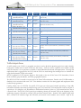
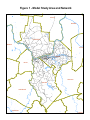
1
KYOVA Model Documentation and User’s Manual
BRIDGING THE GAP IN REGIONAL TRANSPORTATION
400 Third Avenue
P.O. Box 939
Huntington, WV 25712
h t t p : / / w w w. w v s . s t a t e . w v. u s / k y o v a /
December 2013
2 0 4 0 M e tr o p o l i t a n T r a n s p o r t a ti o n P l a n KYOVA INTERSTATE PLANNING COMMISSION
TRAVEL DEMAND MODEL DOCUMENTATION AND USER’S GUIDE
December 2013
Introduction
Kimley-Horn and Associates, Inc. (KHA) is developing a new travel demand model with a validated base year of
2010 for the KYOVA Interstate Planning Commission. In April 2012, a study design was conducted as the first
step of this model development effort. Based on the approach outlined in the study design document, various
components of the KYOVA Travel Demand Model were developed.
The purpose of this report is to document the development process and describe the parameters and structure of
the updated KYOVA Travel Demand Model that was employed as part of the KYOVA MTP update as well as
document the final model calibration and validation measures.
The MPO’s existing model used QRSII software and had a base year of 2000 and a forecast year of 2030. In
2010, as part of the State of West Virginia’s conversion to the TransCAD modeling platform, the Caliper
Corporation delivered a converted base year model in TransCAD for the KYOVA region. This converted
model, to the extent practical, was a replication of the QRSII model and was the starting point for this model
update.
The main objective for developing a new KYOVA travel model system was to provide information necessary for
the analyses to be performed as part of the transportation planning process for the region. These analyses
include those necessary for the development of such required planning documents as the Metropolitan
Transportation Plan, the Transportation Improvement Program, and air quality conformity analysis as required
by the federal Clean Air Act Amendments.
2 0 4 0 M e tr o p o l i t a n T r a n s p o r t a ti o n P l a n
KYOVA INTERSTATE PLANNING COMMISSION
Model Structure
The KYOVA travel demand model follows the basic “four-step” travel demand forecasting process of trip
generation, trip distribution, mode split, and trip assignment.
Trip generation is the first step in the four-step process. Trip generation determines how many trips are made by
residents and employees in each zone in the region. Trips are stratified into two types: productions and
attractions. Trip productions are those trips generated by a zone and are generally associated with the resident
population of the zone. Trip attractions are those trips that are attracted to the zone from another zone. They
are generally associated with the employment in the zone.
Trip distribution is the second step in the four-step process. Trip distribution is the process of connecting trip
productions with trip attractions for each possible combination of zones (zonal interchange). The trip
distribution model uses the gravity model formulation. This formulation states that the number of trips between
two zones is directly proportional to the number of trip productions in the production zone and trip attractions
in the attraction zone, and inversely proportional to the separation between the zones.
Mode split is typically the third step in the four-step process. In cities with extensive transit systems, the travel
characteristics of the population are used to estimate the mode choice between auto and transit. Given the small
portion of daily travel carried by the bus system in the KYOVA region, no separate mode choice or transit
model is included.
Trip assignment is the fourth step in the traditional four-step process. Trip assignment determines which
roadway path will be taken by auto travelers. Auto trips are assigned by time-of-day, using an equilibrium traffic
assignment process. The equilibrium assignment process considers both free-flow travel time and the delay time
due to traffic congestion. At equilibrium, no traveler is able to reduce his or her travel time on a trip by
switching to an alternative route for that trip.
Travel Demand Model Documentation and User’s Guide
2
December 2013
2 0 4 0 M e tr o p o l i t a n T r a n s p o r t a ti o n P l a n
KYOVA INTERSTATE PLANNING COMMISSION
Model Interface
The KYOVA model has been designed to utilize TransCAD’s native scripting language, Geographic Information
System’s Development Kit (GISDK), to provide an intuitive yet flexible interface. The model features an
interface that can run different steps of the model individually or as a set. It also allows functionality in
managing files, scenarios, and mapping. This setup allows for an optimal balance between efficiency and
flexibility in using the KYOVA model.
The interface also allows the user to view and adjust most settings in the model, and to easily switch between
scenarios that contain different sets of data, such as an alternative network, a modified external trip forecast, or a
land use scenario. The interface features tools to assist the user in coding and managing future transportation
projects. Finally, the interface has mapping tools that allow the user to produce maps showing data such as link
level-of-service and daily volumes.
Travel Demand Model Documentation and User’s Guide
3
December 2013
2 0 4 0 M e tr o p o l i t a n T r a n s p o r t a ti o n P l a n
KYOVA INTERSTATE PLANNING COMMISSION
Highway Network and Traffic Analysis Zones
In order to simulate travel within the KYOVA study area, a computer network must be developed that
represents the street system to be modeled. Development of the highway network involved identifying the
network roads to be included and either checking or populating network data in TransCAD.
The KYOVA model boundary includes Cabell and Wayne counties in West Virginia, and Lawrence county in
Ohio. The previous model included Boyd and Greenup counties in Kentucky, but these were not included with
this update since they are both included in the Ashland Travel Demand Model.
The model study area and network can be seen in Figure 1 at the end of this document.
Highway Network Database
A single master network will be used for the base year and all future year models. In TransCAD, the line layer is
not the actual model network used by the travel demand modeling system. Rather, the model network is built
from the line layer. This means the model network is developed as a selection set from the line layer. Having a
selection set means that highway, transit, and walk networks can use a different subset of the entire street
network system.
The highway network contains attributes for each line in the line layer and includes all attributes needed to
perform a traffic assignment. Links that were developed for future year roads were drawn in the network as new
links. Future year attributes were input in a project file and the highway network and project file were connected
by giving each project a unique ID. The project file identifies attributes for the new facilities and indicates the
years and scenarios in which the road is expected to be built. Widened roads include attributes along with
improvement data in the future year scenarios that apply. This methodology allows a single database plus the
project file to handle all potential roads in the network in a compact format. Table 1 below shows the attributes
that are included in the KYOVA highway network database. See Table 26 for Project File attributes.
Table 1 – Highway Network Database Attributes
ID
Field Name
Type
Purpose
Option
Description
1
ID
Integer
Read-only
Link ID
2
Length
Real
Read-only
Length (miles)
Link travel direction code
1
One Way - A to B
0
Two way
3
Dir
Integer
Input
4
Number
String
Reference
Highway Number
5
NAME
String
Reference
Street Name
6
LINKTYPE
String
Old
Old Linktype
7
FED_FC
Integer
Reference
Federal Functional Classification
8
CNTY_FIPS
Integer
Reference
County FIPS Number
-1
One Way - B to A
9
COUNTY
String
Reference
County
10
Alpha_old
Real
Old
Old Alpha value
11
Beta_old
Real
Old
Old Beta value
Travel Demand Model Documentation and User’s Guide
4
December 2013
2 0 4 0 M e tr o p o l i t a n T r a n s p o r t a ti o n P l a n
ID
Field Name
Type
Purpose
Option
KYOVA INTERSTATE PLANNING COMMISSION
Description
In Year 2010 highway network or not
12
Y10_In_Network
Integer
Input
1
not 1
In highway network
Not in highway network
Year 2010 Roadway Facility Type
13
Y10_Fac_Type
Integer
Input
10
Freeway
20
Principal Arterial
21
Principal Arterial w/TWLTL
30
Minor Arterial
31
Minor Arterial w/TWLTL
40
Collector
41
Collector w/TWLTL
50
Local
51
Local w/TWLTL
60
Centroid Connector
70
One Way
80
Ramp
14
Y10_Posted_Speed
Integer
Input
Year 2010 Posted speed (mph)
15
Y10_[AB/BA]_Lanes
Y10_Count
_[Auto/SU/CU/AllVeh]
_[AM/MD/PM/OP/Daily]
Integer
Input
Integer
Input
17
Screen_Line_IDs
Integer
Input
18
PRJ_ID[1/2/3/4/5/6]
Integer
Input
2010 Number of lanes for AB or BA direction
(Year 2010) Traffic counts by three vehicle class
[Auto/SU/CU] by four time-of-day periods
[AM/MD/PM/OP] and total
Screen line / Cut line definition (One single digit
represents the ID of a screen line or cut line)
Future year project ID [1/2/3/4/5/6]
19
Area_Type
Integer
Output
Area type (by 4 category)
16
20
In_Network
1
CBD
2
Urban
3
Suburban
4
Rural
Integer
Scenario
In (Scenario year) highway network or not
21
Fac_Type
Integer
Scenario
(Scenario year) Roadway Facility Type
22
Posted_Speed
Integer
Scenario
(Scenario year) Posted speed (mph)
23
[AB/BA]_Lanes
Integer
Scenario
(Scenario year) Number of lanes for AB or BA direction
24
Alpha
Real
Output
Alpha parameter for BPR function
25
Beta
Real
Output
Beta parameter for BPR function
26
[AB/BA]_Preload
Real
Output
Preload traffic for AB or BA direction
27
FF_Speed
Real
Output
Free flow speed (mph)
28
FF_TT
[AB/BA]_Cong_Speed
_[AM/MD/PM/OP]
Real
Output
Real
Output
Free flow travel time (minutes)
Congested speed (mph) by travel direction and time-ofday
29
Travel Demand Model Documentation and User’s Guide
5
December 2013
2 0 4 0 M e tr o p o l i t a n T r a n s p o r t a ti o n P l a n
ID
30
31
32
33
34
35
36
37
38
Field Name
[AB/BA]_Cong_TT
_[AM/MD/PM/OP]
[AB/BA]_MSA_Speed
_[AM/MD/PM/OP]
[AB/BA]_MSA_TT
_[AM/MD/PM/OP]
[AB/BA/BothDir]_Capa
_[AM/MD/PM/OP/Daily]
[AB/BA/BothDir]_VOC
_[AM/MD/PM/OP/Daily]
[AB/BA/BothDir]_LOS
_[AM/MD/PM/OP/Daily]
[AB/BA/BothDir]_Vol
_[Auto/SU/CU/AllVeh]
_[AM/MD/PM/OP/Daily]
[AB/BA/BothDir]_VMT
_[Auto/SU/CU/AllVeh]
_[AM/MD/PM/OP/Daily]
[AB/BA/BothDir]_VHT
_[Auto/SU/CU/AllVeh]
_[AM/MD/PM/OP/Daily]
Type
Purpose
Real
Output
Real
Output
Real
Output
Real
Output
Real
Output
String
Option
KYOVA INTERSTATE PLANNING COMMISSION
Description
Congested travel time (minutes) by travel direction and
time-of-day
MSA speed for feedback loop (mph) by travel direction
and time-of-day
MSA travel time for feedback loop (minutes) by travel
direction and time-of-day
Link capacity by travel direction and time-of-day
Volume to capacity ratio by travel direction and time-ofday
Level of service by travel direction and time-of-day
Output
C
v/c < 0.7
D
v/c >= 0.7 and <0.85
E
v/c >= 0.85 and <1
F
v/c >1
Real
Output
Traffic volume by travel direction, vehicle class, and timeof-day
Real
Output
Vehicle miles traveled by travel direction, vehicle class,
and time-of-day
Real
Output
Vehicle hours traveled by travel direction, vehicle class,
and time-of-day
Traffic Analysis Zones
A traffic analysis zone (TAZ) is a geographic area that is used to divide the planning region into small, relatively
homogenous similar areas in terms of land use and activity. TAZs are used to represent travel within a model
study area because it is not practical or feasible to model individual households and employment. Housing and
employment data is aggregated to the TAZ, and the TAZs are used through the model process to calculate the
origin and destination of trips in the model.
KYOVA updated its TAZ structure slightly in 2011 based on the new 2010 Census TAZ boundaries, Census
block and block group boundaries, and other geographical barriers.
The KYOVA TAZs are stored as an area layer in the TransCAD environment. Based on the TAZ ID number, a
database is then associated with each TAZ. This database contains all of the demographic and employment data
needed for trip generation.
Creating unique sets of TAZ IDs for specific TAZ types can often speed external processing of trip table
information and make data analysis and processing easier. In TransCAD, TAZ and network nodes are all part of
a point layer. It is helpful to use ID numbers to differentiate between a point as a TAZ centroid and one that is
a network node. The KYOVA TAZ/point layer numbering scheme puts internal TAZs at the beginning of the
numbering sequence, followed by external TAZs and then network nodes. Internal TAZ numbers begin with
ID 1; external TAZ numbers begin with ID 9001; and network node numbers start at 10001. Gaps in the
Travel Demand Model Documentation and User’s Guide
6
December 2013
2 0 4 0 M e tr o p o l i t a n T r a n s p o r t a ti o n P l a n
KYOVA INTERSTATE PLANNING COMMISSION
numbering system are not an issue for TransCAD because the ID (which must be unique) is interpreted by
TransCAD as a label, not a number.
Table 2 – TAZ Numbering Summary
Summary
TAZ Range
TAZs
Internal TAZs
1 - 9000
299
External TAZs
9001 - 9020
20
Total
319
The KYOVA TAZ structure can be seen in Figure 2 at the end of this document.
External Zone Structure
There are 20 external stations in the 2010 KYOVA model compared to 27 external stations in the previous
KYOVA model. External stations changed due to the deletion of Boyd and Greenup counties in Kentucky
from this model update.
Locations of the 2010 model external stations can be seen in Figure 3 at the end of this document.
Zonal Data
Zonal data for the KYOVA model was obtained from several sources, including the U.S. Census, and InfoUSA
(a commercial provider of employment data). 2010 Census data was used to develop the 2010 household totals
by TAZ. Information from the 2010 Census and the American Community Survey (ACS) helped in developing
household totals by household size and number of workers.
2010 employment data was obtained by location by KYOVA through their contract with Reference USA
(InfoUSA). The data was cross checked with employment data from Workforce WV to improve accuracy.
Employment data were then grouped into five main categories:
·
Industrial (SIC Groups 1-49) – Includes employment such as manufacturing, agriculture, construction,
and freight services.
·
Retail (SIC Groups 50-59, excluding 55 and 58) – Includes wholesale trade and retail trade.
·
Highway Retail (SIC Groups 55 and 58) – Includes retail that falls into the category of fast food
restaurants, service stations, and other types of eating and drinking establishments.
·
Office (SIC Groups 60-69, 90-98) – This category includes finance, insurance, real estate, and
governmental type offices.
·
Service (SIC Groups 70-89, 99) – Employment data falling into this category are generally classified as
hotels, personal and business services, auto repair, and other service type establishments.
Travel Demand Model Documentation and User’s Guide
7
December 2013
2 0 4 0 M e tr o p o l i t a n T r a n s p o r t a ti o n P l a n
KYOVA INTERSTATE PLANNING COMMISSION
Table 3 – TAZ Attributes
ID
Field Name
Type
Purpose
Options
Description
TAZ ID
1
ID
Integer
Read-only
2
Area
Real
Read-only
< 9000 Internal TAZ centroids
9001External stations
9020
Area size (square miles)
3
County
String
Input
County name (see above)
4
Zone_Type
String
Reference
Internal or External
Area type (by 4 category)
5
Area_Type
Integer
Input
1
CBD
2
Urban
3
Suburban
4
Rural
6
Terminal_Time_P
Integer
Input
Terminal time of the zone (minutes) for productions
7
Real
Input
Terminal time of the zone (minutes) for attractions
Integer
Scenario
(scenario year) Number of households by household size and
vehicle ownership
Integer
Scenario
10
Terminal_Time_A
[HH1/HH2/HH3/HH
4]_[VH0/VH1/VH2/
VH3]
[WK0/WK1/WK2/
WK3]_HH
Students
Integer
Scenario
(scenario year) Number of households by number of worker in
household
(scenario year) Total number of school age children
11
Total_HH
Integer
Scenario
(scenario year) Total number of households
12
Total_Population
Integer
Scenario
(scenario year) Total population
13
HwyRet
Integer
Scenario
(scenario year) Employment in Highway Retail category
8
9
14
Ind
Integer
Scenario
(scenario year) Employment in Industry category
15
Retail
Integer
Scenario
(scenario year) Employment in Retail category
16
Office
Integer
Scenario
(scenario year) Employment in Office category
17
Service
Integer
Scenario
(scenario year) Employment in Service category
18
Total_Emp
Integer
Scenario
(scenario year) Total employment
19
School_Enrollment
Integer
Scenario
(scenario year) K-12/College school Enrollment
20
ADT
Real
Scenario
(scenario year) ADT at external station
21
Pct_[Auto/SU/CU]
Pct_IE_[Auto/SU/CU
]
Pct_[AM/MD/PM/
OP]
HBW_P_[AM/MD/
PM/OP]
HBW_A_[AM/MD/
PM/OP]
Real
Scenario
Real
Scenario
(scenario year) percent by vehicle class at external station
(scenario year) In-bound factor by vehicle class at external
station
Real
Scenario
(scenario year) Time of day split at external station
Real
Output
HBW productions by time-of-day
Real
Output
HBW attractions by time-of-day
22
23
24
25
Travel Demand Model Documentation and User’s Guide
8
December 2013
2 0 4 0 M e tr o p o l i t a n T r a n s p o r t a ti o n P l a n
ID
Field Name
40
HBS_P_[AM/MD/PM
/OP]
HBS_A_[AM/MD/
PM/OP]
HBO_P_[AM/MD/
PM/OP]
HBO_A_[AM/MD/
PM/OP]
NHB_P_[AM/MD/
PM/OP]
NHB_A_[AM/MD/
PM/OP]
IE_Auto_P_[AM/MD
/PM/OP]
IE_Auto_A_[AM/MD
/PM/OP]
LT_TRK_P_[AM/MD
/PM/OP]
LT_TRK_A_[AM/MD
/PM/OP]
SU_TRK_P_[AM/MD
/PM/OP]
SU_TRK_A_[AM/MD
/PM/OP]
CU_TRK_P_[AM/
MD/PM/OP]
CU_TRK_A_[AM/
MD/PM/OP]
Pop_Density
41
Emp_Density
26
27
28
29
30
31
32
33
34
35
36
37
38
39
Type
Purpose
Options
KYOVA INTERSTATE PLANNING COMMISSION
Description
Real
Output
HBS productions by time-of-day
Real
Output
HBS attractions by time-of-day
Real
Output
HBO productions by time-of-day
Real
Output
HBO attractions by time-of-day
Real
Output
NHB productions by time-of-day
Real
Output
NHB attractions by time-of-day
Real
Output
Balanced IE Auto productions by time-of-day
Real
Output
Balanced IE Auto attractions by time-of-day
Real
Output
SU truck productions by time-of-day
Real
Output
Balanced SU truck attractions by time-of-day
Real
Output
SU truck productions by time-of-day
Real
Output
Balanced SU truck attractions by time-of-day
Real
Output
CU truck productions by time-of-day
Real
Output
Balanced CU truck attractions by time-of-day
Real
Output
Population density of the zone (person per square mile)
Real
Output
Employment density of the zone (employment per square mile)
Travel Demand Model Documentation and User’s Guide
9
December 2013
2 0 4 0 M e tr o p o l i t a n T r a n s p o r t a ti o n P l a n
KYOVA INTERSTATE PLANNING COMMISSION
Trip Generation
Since household travel behavior surveys were not conducted as part of the development of the KYOVA regional
travel demand model, trip generation rates were “borrowed” from suitable urban areas that had recently
conducted such surveys as a part of their model development.
As a precursor to this, KHA had NuStats mine data from recent travel surveys they conducted to test the
transferability of trip rate inputs from other areas to the KYOVA modeling area. First, NuStats identified study
areas from an existing database of household travel surveys that closely mirrored the population size and sociodemographic mix of residents in the Huntington, WV area. Once these were identified, NuStats selected the
appropriate household travel survey databases for this effort. Finally, NuStats prepared and analyzed the data for
computation of single- and cross-classification trip generation rates with the purpose of informing the trip
generation model for KYOVA.
Trip rates were computed on data from five selected survey data files from the following locations:
·
Rogue Valley, Oregon
·
Chattanooga, Tennessee
·
Knoxville, Tennessee
·
Ohio “Cluster” #1 (Hancock, Hardin, Logan, and Champaign Counties)
·
Ohio “Cluster” #2 (Adams, Brown, Highland, Scioto, Fayette, Pike, Ross and Vinton Counties)
Table 4 – 2006-2008 ACS Distribution by Selected Geography (From NuStats report)
KYOVA
Rogue Valley
Chattanooga
Knoxville
Ohio Cluster #1
Ohio Cluster #2
Total Households
83,544
69,533
169,257
352,536
77,383
127,270
White
94.4%
91.6%
81.4%
91.0%
95.4%
94.7%
African American
3.1%
0.6%
14.9%
5.5%
1.3%
2.4%
Other
1.7%
7.8%
3.7%
3.4%
3.3%
2.9%
HH Size 1
29.7%
28.3%
27.9%
28.8%
27.1%
25.8%
HH Size 2
36.6%
36.6%
36.4%
36.3%
36.5%
35.0%
HH Size 3
16.4%
14.9%
15.6%
16.7%
14.5%
17.3%
HH Size 4+
17.3%
20.2%
20.2%
18.2%
22.0%
21.9%
HH Income <$25,000
35.8%
31.0%
26.7%
28.2%
25.4%
33.5%
$25,000 to $50,000
28.5%
29.3%
27.8%
27.2%
27.2%
28.9%
$50,000 to $75,000
17.2%
15.9%
18.7%
19.0%
22.1%
18.8%
$75,000 or more
18.5%
23.7%
26.8%
25.7%
25.3%
18.7%
Age <25 yrs
31.6%
30.6%
36.4%
32.6%
34.9%
32.5%
65+ yrs
15.7%
15.0%
14.0%
14.4%
13.5%
13.9%
65 Years and Over
0.9%
7.3%
2.5%
2.2%
1.6%
0.8%
Travel Demand Model Documentation and User’s Guide
10
December 2013
2 0 4 0 M e tr o p o l i t a n T r a n s p o r t a ti o n P l a n
KYOVA INTERSTATE PLANNING COMMISSION
This data was combined with trip rate information from other sources (old KYOVA model, 2000 RIC model,
Ashland model, Goldsboro NC model, Greenville NC model) and engineering judgment was used to determine
the best rates for use in the KYOVA model. The NuStats Trip Rate Transferability Analysis Final Report is available
under separate cover.
Internal Trip Productions
The trip generation models used in the KYOVA regional travel demand model explicitly recognizes the
connection between household composition and trip-making characteristics. The model estimates person-trip
generation for four purposes, based on household characteristics that are relatively easy to obtain, derive, and
forecast. These trip purposes are:
Home-based work (HBW)
Home-based school (HBS)
Home-based other (HBO)
Non-home-based (NHB)
The methodology employed recognizes the strong relationships between travel behavior and household “type”,
reflecting the degree to which household composition influence travel characteristics.
Table 5 – Trip Production Variable by Purpose
Independent Variable
Workers/Household
HBW
HBS
NHB
X
X
X
HH Size by Vehicles
Students
HBO
X
Home-Based Work (HBW)
Workers/household is a strong predictor of home-based work trips. Many other variables (income, vehicles, and
persons) share co-linearity’s with workers/household, but are weaker predictors. Because of their interactions,
combining these variables with workers/household does not substantially improve the explanatory power of the
model.
As shown in Table 6 on the next page, the increase in HBW trip rates associated with the number of workers
per household is not linear. This is assumed because of an increasing proportion of part-time jobs in multiworker households, which increase the likelihood that one household worker will not make a work trip every
workday.
HBW trip rates were borrowed from Ohio Cluster #2 in the NuStats data and adjusted (up or down) based on
observed VMT in the area for each county. Adjustments were made by county to account for differences in
travel characteristics between the different counties that became apparent when comparing model VMT versus
actual VMT.
Travel Demand Model Documentation and User’s Guide
11
December 2013
2 0 4 0 M e tr o p o l i t a n T r a n s p o r t a ti o n P l a n
KYOVA INTERSTATE PLANNING COMMISSION
Table 6 – Household Trip Rates for HBW Trips
Workers/HH
HBW Trips/HH
Lawrence County
0
0.00
1
1.717
2
2.533
3+
3.544
Cabell County
0
0.00
1
2.222
2
3.278
3+
4.587
Wayne County
0
0.00
1
1.010
2
1.490
3+
2.085
Home-Based School (HBS)
Due to the availability of data on the number of students per household, the Home-based school trip model is a
simple calculation of number of students times a trip rate. For this model, the number of students was
determined to be the most predictive of Home-based school trips.
HBS trip rates were borrowed from the 2000 RIC travel demand model and adjusted based on observed VMT in
the area for each county. Adjustments were made by county to account for differences in travel characteristics
between the different counties that became apparent when comparing model VMT versus actual VMT.
Table 7 – Household Trip Rates for HBS Trips
Students
HBS Trips/Student
Lawrence County
1
1.244
Cabell County
1
1.610
Wayne County
Travel Demand Model Documentation and User’s Guide
12
December 2013
2 0 4 0 M e tr o p o l i t a n T r a n s p o r t a ti o n P l a n
1
KYOVA INTERSTATE PLANNING COMMISSION
0.732
Home-Based Other (HBO)
This trip category combines all home-based trips not covered by HBW and HBS (such as shopping and
recreation for example). As such, there is no single, clear-cut variable that determines HBO trip rates. For this
model, the combination of household size and available vehicles was determined to be the most predictive of
Home-based other trips.
HBO trip rates were borrowed from the Ashland travel demand model and adjusted based on observed VMT in
the area for each county. Adjustments were made by county to account for differences in travel characteristics
between the different counties that became apparent when comparing model VMT versus actual VMT.
Table 8 – Household Trip Rates for HBO Trips
Household Size
0 Veh Available
1 Veh Available
2+ Veh Available
1
1.193
1.836
1.836
2
2.203
3.075
3.075
3
3.522
4.379
4.379
4+
4.536
5.670
6.557
1
1.544
2.376
2.376
2
2.851
3.980
3.980
3
4.558
5.667
5.667
4+
5.870
7.337
8.485
1
0.702
1.080
1.080
2
1.296
1.809
1.809
3
2.072
2.576
2.576
4+
2.668
3.335
3.857
Lawrence County
Cabell County
Wayne County
Non-Home Based (NHB)
These trips differ fundamentally from the other purposes, since they occur away from the home, and are not
associated geographically with the household location. The production end of the NHB trips merely provides an
estimate of the NHB trips associated with each household, and, in aggregate, a control total for the entire study
area. Typically the attraction ends of HB trips determine the locations of these non-directional trips.
Travel Demand Model Documentation and User’s Guide
13
December 2013
2 0 4 0 M e tr o p o l i t a n T r a n s p o r t a ti o n P l a n
KYOVA INTERSTATE PLANNING COMMISSION
For this model, it was decided to use household size by vehicles available to determine NHB trips. NHB trip
rates were borrowed from the 2000 RIC travel demand model and the Ashland travel demand model and
adjusted based on observed VMT in the area for each county. Adjustments were made by county to account for
differences in travel characteristics between the different counties that became apparent when comparing model
VMT versus actual VMT.
Table 9 – Household Trip Rates for NHB Trips
Household Size
0 Veh Available
1 Veh Available
2+ Veh Available
1
0.575
0.986
0.986
2
0.979
1.420
1.420
3
1.573
1.921
1.921
4+
1.799
2.848
2.848
1
0.744
1.276
1.276
2
1.267
1.837
1.837
3
2.035
2.486
2.486
4+
2.328
3.685
3.685
1
0.338
0.580
0.580
2
0.580
0.835
0.835
3
0.925
1.130
1.130
4+
1.130
1.675
1.675
Lawrence County
Cabell County
Wayne County
Internal Trip Attractions
Corresponding trip attraction models were developed for each of the four trip production purposes. For all
home-based trips, the attraction end of the trip is defined as the non-home end. In the case of non-home based
trips, the trip attraction model provides both origin and destination information, since, by definition, these trips
do not originate from the home.
Regression equations are widely used for estimating trip attractions in travel demand models. The general form
of the regression equation uses several known independent variables to predict the dependent variable – trip
attractions – for each trip purpose.
Similar to trip productions, trip attraction rates were borrowed from a number of different sources including the
old KYOVA model, as well as the 2000 RIC travel demand model and the Ashland travel demand model.
Engineering judgment was used to determine the specific rates by purpose and type.
Travel Demand Model Documentation and User’s Guide
14
December 2013
2 0 4 0 M e tr o p o l i t a n T r a n s p o r t a ti o n P l a n
KYOVA INTERSTATE PLANNING COMMISSION
Table 10 – Person Trip Attraction Factors
Purpose
Households
Industrial
Retail
High-Retail
Office
Service
School Enrollment
HBW
1.45
--
--
--
--
--
--
HBS
--
--
--
--
--
--
1.5
HBO
1.48
.44
2.976
10.58
.44
1.7
--
NHB
.268
.285
4.7
4.7
.285
.889
--
External Trips
The number of base year vehicle trips at each external station was set equal to the average daily traffic (ADT)
traffic count at the station. Using the observed vehicle classification, time-of-day, and other information, the
ADTs at external stations are further divided by the following components:
·
Auto, SU, CU
·
EE Auto, EI Auto, EE SU, EI SU, EE CU, EI CU
Three vehicle classes are modeled and assigned to the highway network in the KYOVA model: Auto, Single-Unit
Truck (SU), and Combination-Unit Truck (CU). ADTs at all external stations are split into these three vehicle
classes first based on existing model information.
Percent splits between EE and EI trips at each external station were also based on existing model information
except in cases where the location of the external station changed. At these locations, information from the
Ashland model as well as engineering judgment was used to estimate appropriate values.
Time-of-day trip factors for external stations were developed by taking an average of the internal trip purposes
(HBW, HBO, NHB) for each time of day. HBS trips were not included because of the small amount coming
into the area from external locations.
Table 11 –External Station ADT and Vehicle Classification Splits
Station
Location
County
2010 AADT
% Auto
% SU Truck
% CU Truck
% Through
9001
US 52 N
Lawrence
9120
90%
6.0%
4.0%
40%
9002
OH 522
Lawrence
660
97%
2.0%
1.0%
0.0%
9003
OH 93 N
Lawrence
1800
92%
5.0%
3.0%
0.0%
9004
OH 141
Lawrence
730
95%
3.0%
2.0%
0.0%
9005
OH 7 E
Lawrence
3120
95%
3.0%
2.0%
5.5%
9006
WV 2 E
Cabell
6000
95%
3.0%
2.0%
0.5%
9007
Mason Rd
Cabell
1640
97%
2.0%
1.0%
0.0%
9008
I-64 E
Cabell
32500
85%
9.0%
6.0%
8.6%
9009
US 60 E
Cabell
9000
90%
6.0%
4.0%
0.0%
9010
Bulls Gap
Cabell
700
97%
2.0%
1.0%
0.0%
Travel Demand Model Documentation and User’s Guide
15
December 2013
2 0 4 0 M e tr o p o l i t a n T r a n s p o r t a ti o n P l a n
KYOVA INTERSTATE PLANNING COMMISSION
9011
WV 10
Cabell
3500
95%
3.0%
2.0%
0.4%
9012
CR 21
Wayne
300
97%
2.0%
1.0%
0.0%
9013
WV 37 E
Wayne
800
96%
2.0%
2.0%
0.0%
9014
12-Pole Creek Rd
Wayne
300
97%
2.0%
1.0%
0.0%
9015
US 52 S
Wayne
6600
95%
3.0%
2.0%
0.0%
9016
WV 37 W
Wayne
9300
95%
3.0%
2.0%
0.0%
9017
I-64 W
Wayne
27500
85%
9.0%
6.0%
8.3%
9018
US 60 W @ CL
Wayne
9400
95%
3.0%
2.0%
2.0%
9019
US 60 W @ River
Lawrence
34000
94%
4.0%
2.0%
10.3%
9020
OH 93 S @ River
Lawrence
10500
95%
3.0%
2.0%
3.0%
Through trips were directly modeled as in-bound and out-bound trips. The total number of in-bound and outbound trips was balanced by holding the in-bound total number of trips constant. External-Internal truck trips
include SU and CU trucks. For each classification, total trips produced at each external station are a function of
ADT, percent by class, percent by time-of-day and percent EI. Based on the Quick Response Freight Manual
(QRFM), the EI trip production was added to the internal truck trips and balanced together with the internal
truck trip attractions by holding the production end constant. Similar to EI trucks, EI auto trips are a function
of ADT, percent auto, percent time-of-day and percent EI. EI auto attractions were derived at the TAZ level
based on various employment categories and total number of households. Linear regression models based on
employment and number of households in each internal zone was developed for EI auto trip attractions. The
linear regression coefficients were borrowed from surveys in North Carolina. EI auto trip attraction rates are
summarized in Table 12.
Table 12 – EI Auto Trip Attraction Model Coefficients
Variable
Coefficient
Employment (High-Retail)
3.74
Employment (Industry)
0.40
Employment (Retail)
3.74
Employment (Office)
0.45
Employment (Service)
0.45
Households (Total)
0.25
School Enrollment
0.25
External trip productions were held constant at the external station locations since there is a higher level of
certainty with the volumes at these locations than the attractions being derived at the TAZ level.
External trips are distributed using the gravity model, the same as internal trips.
Travel Demand Model Documentation and User’s Guide
16
December 2013
2 0 4 0 M e tr o p o l i t a n T r a n s p o r t a ti o n P l a n
KYOVA INTERSTATE PLANNING COMMISSION
Truck Trip Model
In the KYOVA model, internal truck travel was estimated for three vehicle classification types: four-tire
commercial vehicles (Light Truck), single unit trucks with six or more times (SU), and combination trucks (CU).
Total truck trips using the highway network can be divided into three types: External-External (EE), ExternalInternal (EI), and Internal trips.
Internal truck trip generation is based on the linear regression models by various employment categories and
number of households as defined in the QRFM procedures. The default commercial vehicle trip rates in the
QRFM manual were used as the starting points. It is recognized that the QRFM rates are based on Phoenix,
Arizona’s survey, and truck trip rates may vary considerably from region to region. Since a truck land use trip
generation survey for the KYOVA region does not exist, common practice suggests that the QRFM rates should
be coded and then adjusted during the calibration effort. Based on this, the trip generation rates shown in Table
13 were developed as QRFM tailored rates specific to the KYOVA model application.
Table 13 – Commercial Vehicle Trip Generation Rates
Variable
Light Truck
SU Truck
CU Truck
Employment (High-Retail)
0.888
0.164
0.065
Employment (Industry)
0.938
0.157
0.104
Employment (Retail)
0.888
0.164
0.065
Employment (Office)
0.437
0.022
0.009
Employment (Service)
0.467
0.305
0.075
Households (Total)
0.251
0.050
0.038
Production and attractions for internal truck trips are 50/50 splits after the total demand is estimated. The SU
and CU truck productions and attractions from the EI and internal truck trip generation step are added together,
and distributed using the gravity model. The productions and attractions for SU and CU trucks were balanced
by holding the production end constant.
Due to a lack of significant time-of-day classification count coverage, the time-of-day split factors for internal
truck trips were borrowed from the Memphis, TN model. These splits can be seen in the table below.
Table 14 – Truck Time of Day Factors
Purpose
AM
MD
PM
OP
LT_TRK
17.10
27.20
29.20
26.50
SU_TRK
17.90
31.40
27.80
22.90
CU_TRK
16.20
27.50
26.90
29.40
Travel Demand Model Documentation and User’s Guide
17
December 2013
2 0 4 0 M e tr o p o l i t a n T r a n s p o r t a ti o n P l a n
KYOVA INTERSTATE PLANNING COMMISSION
Trip Distribution
Trip distribution, the second step in the traditional four-step modeling process, matches person trip-ends (trip
productions and trip attractions) estimated in the trip generation process to produce production-attraction
person trip tables by purpose. To complete this process, a trip distribution has to be used that attempts to
account for differences in attractiveness and accessibility of each possible zone-zone interchange in the model,
reflecting each zone’s land use and roadway network characteristics. The KYOVA model uses the most
common type of trip distribution model, the gravity model.
Gravity Model
The trip distribution step in the traditional four-step modeling process matches the person trip end (trip
productions at the households and trip attractions at employment sites) estimated in trip generation to produce
production-attraction person trip tables by purpose. The underlying assumption is that the trip productions and
attractions are distributed in a manner that accounts for differences in accessibility and attractiveness of each
zone pair reflecting the land use and transportation system characteristics.
The gravity model for trip distribution is defined as follows:
ö
æ
÷
ç
A j F ij K ij ÷
ç
T ij = Pi ç zones
÷
ç å Ak F ik K ik ÷
ø
è k=1
where:
Tij is the number of trips from zone i to zone j
Pi is the number of trip productions in zone i
Aj is the number of trip attractions in zone j
Fij is the "friction factor" relating the spatial separation between zone i and zone j
Kij is an optional trip distribution adjustment factor for interchanges between zone i and zone j
The friction factors are inversely related to spatial separation of the zones—as the travel time increases, the
friction factor decreases. A number of different functional forms have been used for friction factors. In fact,
early gravity models used "hand fitted" friction factors. More recently, however, it has been discovered that the
"gamma" function does a very good job for trip distribution. Using such a function produces a smooth,
continuous curve. The gamma function can be stated as follows:
b
F ij = a * t ij * e
where:
c* t ij
Fij is the friction factor
a, b, and c are model coefficients
tij is the travel time
e is the base of the natural logarithms
Table 15 – Gamma Function Settings
Purpose
HBW
a
b
c
38375
0.140
0.120
Travel Demand Model Documentation and User’s Guide
18
December 2013
2 0 4 0 M e tr o p o l i t a n T r a n s p o r t a ti o n P l a n
HBS
50000
0.550
0.100
HBO
80000
1.700
0.060
NHB
40000
0.450
0.095
IE_AUTO
500000
2.500
0.600
LT_TRK
418908
1.300
0.080
SU_TRK
418908
1.300
0.050
CU_TRK
200000
1.000
0.060
KYOVA INTERSTATE PLANNING COMMISSION
Travel Impedances
One of the major inputs to gravity model-based trip distribution models is the travel impedance matrix. For the
KYOVA trip distribution model, travel impedances are based on highway travel times. The highway travel times
are based on shortest travel paths for each possible zonal interchange and are augmented with intrazonal times
and terminal times prior to distribution.
Free flow speeds are the speeds at which a vehicle can traverse the roadways without interference from other
vehicles. The only delay that is experienced by vehicles at free-flow is the delay caused by intersection controls –
signal lights, stop signs, and yield signs. The uncongested speeds used in the KYOVA model are average speeds
based on free-flow conditions which do not explicitly treat the delay at intersections. Free-flow speeds are
calculated from the model posted speeds multiplied by a speed factor (found in the speed_factor.bin file). This
was done for two reasons: (1) average speeds are realistic since vehicles tend to travel above the speed limit
except for delay at intersections, and (2) for a regional network, it is more important to have consistent speeds
than to have additional detail.
Once link-specific uncongested travel times have been estimated, shortest travel time paths can be built, and
zone-to-zone travel times can be saved in matrices.
Estimated congested travel times are based on the expected travel speeds that would be encountered in a peak
period. Since trip distribution is performed prior to traffic assignment, the congested times must be developed
through an iterative process.
·
Link specific free-flow travel times are calculated
·
Shortest path interzonal travel time matrices (skims) are determined using the traffic assignment model
in TransCAD for free-flow travel times; skims are augmented with terminal times and intrazonal times
·
Trip distribution is performed for all trip purposes based on the free-flow skims
·
Vehicle trip tables are developed and peak period assignments are performed, and congested times are
saved to a matrix
·
Trip distribution is performed again based on congested skims
The model is also set up to have free flow speed adjustment factors which can vary by area type as well as
congested speed adjustment factors which can vary by time of day and area type (found in speed_factor.bin file).
While free flow speed adjustment factors aid in model calibration, congested speed adjustment factors give the
model a good start for the first iteration. If we use free flow skims for the first iteration as impedance, the model
Travel Demand Model Documentation and User’s Guide
19
December 2013
2 0 4 0 M e tr o p o l i t a n T r a n s p o r t a ti o n P l a n
KYOVA INTERSTATE PLANNING COMMISSION
will converge slowly. By providing congested speed estimates for the first iteration before assignment, we help
the model start with congested skims that are similar to reality or the assignment results.
Terminal/Intrazonal Travel Times
The highway network is represented by roads classified as collectors, arterials and freeways with some local roads
added for network connectivity. Household surveys, however, query people on their overall trip travel time.
This travel time considers the access and egress time at either end of the trip. Since the model will not simulate
each individual household or business, the time needed to access a vehicle and travel to a road which is actually
in the model must be considered. At the destination end, people must find parking and walk to their final
destination. Consequently, some way must account for travel time not occurring on the simulated model
network. This accounting mechanism is referred to as terminal time.
Terminal time can vary by setting. Typically, in a CBD setting, it takes longer to find a parking space and walk to
the final destination than in a rural or even an urban setting where the parking is closer to the doorstep. NCHRP
Report 365: Travel Estimation Techniques for Urban Planning provides some general guidelines for these terminal
times. These terminal times were compared against actual field tests, and terminal times of one minute were
chosen for rural, suburban and urban area types, and terminal times of two minutes were chosen for CBD area
types.
Trips that stay within a TAZ are referred to as intrazonal trips. Intrazonal trips are not assigned to the model
network. To properly account for these trips in the distribution process, an intrazonal travel time must be
computed. For the KYOVA model, intrazonal travel times are calculated by taking one half of an average travel
time to three neighboring zones, along with the terminal time. This process accounts for variable zone sizes
(larger zones at the model periphery and smaller zones in the core).
Average Trip Length Targets
Since no travel surveys have been conducted for the KYOVA area, data from previous information will be
utilized to establish whether the 2010 model average trip lengths are adequate for model calibration.
Table 16 shows the comparison of travel times from available data.
Table 16 – Average Trip Lengths (min)
Purpose
O-D Survey 60’s
1972 Model
1990 Model
Ashland 2002
2002 Survey
2010 Model
HBW
13.2
13.1
20.75
20.976
16.5
17.2
HBS
8.5
7.2
15.90
--
19.5
17.3
HBO
10.6
10.6
18.71
19.465
15.4
15.3
NHB
10.1
10.1
15.66
20.364
13.3
13.1
IE_Auto
19.9
--
--
--
--
32.0
LT_Trk
9.5
9.7
--
--
13.3
11.4
SU_Trk
--
--
--
--
--
17.3
CU_Trk
--
--
--
--
--
20.3
Travel Demand Model Documentation and User’s Guide
20
December 2013
2 0 4 0 M e tr o p o l i t a n T r a n s p o r t a ti o n P l a n
KYOVA INTERSTATE PLANNING COMMISSION
Mode Split/Time of Day
In the mode split step, the total person trips that are output from the trip generation and trip distribution steps
are split into trips by mode. In many models, particularly those in large urban areas with significant transit
systems, a mode choice model is used to identify which trips use automobile, transit, walk, or other forms of
travel. In such a model, the characteristics of travelers and modes are used to calculate the probabilities of using
each mode.
The development of a true mode choice model for the KYOVA region is not planned at this time. Due to the
high level of investment required to create a sound mode choice model and the relatively low number of nonauto users, the mode split step for the KYOVA model has been developed as a factoring process. The mode
split procedure has been designed in TransCAD in a modular format to allow for additional capabilities, such as
a true mode choice model, if in the future such a submodel is deemed as required for the region. In the current
process, the person trips by purpose will be factored to eliminate the non-motorized, transit and auto passenger
trips, leaving only the auto driver (vehicle) trips.
These factors were derived from the 1998 Greenville, NC and 2003 Goldsboro, NC household travel surveys,
and are based on trip purpose and distance. Through analysis of the survey data, it was found that the most
reliable way to reduce the trip tables to automobiles only was based on distance. Shorter trips were much more
likely to be classified as walk, bike, or transit/school bus, while longer trips were made almost exclusively by
automobile. Table 17 shows the mode split factors for the KYOVA model. The mode split factors can be read
as a percentage. The HBW factor of .70 for trips between 0-1 miles means 70% of these trips are automobile
trips. These factors are required only for the non-commercial internal trip purposes, since the external-internal
and commercial trip purposes are treated as vehicle trips through the entire model.
Table 17 – Mode Split Factors
Distance
HBW
HBS
HBO
NHB
0-1 Miles
0.70
0.57
0.78
0.85
1-2.5 Miles
0.98
0.87
0.975
0.98
2.5-7.5 Miles
0.98
0.90
1.00
0.985
7.5+ Miles
1.00
0.95
1.00
0.985
The mode split procedure is also the point where the internal trip purposes are taken from person trips to vehicle
trips using vehicle occupancy factors. Vehicle occupancy factors for the KYOVA model were derived from the
old KYOVA model. Table 18 shows the occupancy factors used in the KYOVA model, along with occupancy
rates from other sources as a point of comparison.
Table 18 – Vehicle Occupancy Factors
Purpose
1990 HIATS
2004 Clarksville, TN
2000 Ashland, KY
Old KYOVA Model
KYOVA Model
HBW
1.27
1.08
1.11
1.54
1.35
HBS
4.56
3.58
--
2.29
2.00
Travel Demand Model Documentation and User’s Guide
21
December 2013
2 0 4 0 M e tr o p o l i t a n T r a n s p o r t a ti o n P l a n
·
·
·
KYOVA INTERSTATE PLANNING COMMISSION
HBO
1.64
1.20
1.58
1.55
1.54
NHB
1.35
1.15
1.66
1.73
1.70
1990 HIATS from HIATS Long Range Plan – Technical Analysis 1997
2004 Clarksville, TN from Clarksville Urbanized Area Travel Demand Model – Model Documentation and Users Guide
2000 Ashland and Old KYOVA Model from Final Draft Report – Updating and Validating the Travel Demand Forecasting Process –
KYOVA, October 2004
Next, time-of-day/direction split factors convert the vehicle trip tables from production-attraction format to
origin-destination format. At the same time, daily trips are split into four time periods; morning, midday,
afternoon, and night.
In a highway assignment, peak period trip tables representing more than one hour are normally assigned while
link capacities are specified in vehicles per hour. As a result, factors specifying the percentage of trips that take
place within the peak hour of the time period being assigned are used to relate the hourly capacities to multiplehour trip tables (see Capacity Factor in Table 20).
Table 19 summarizes the percent of trips by starting time for the 24 one-hour periods in a day for each internal
trip purpose. This information was taken directly from the old KYOVA model.
Table 19 – Percent of Trips by Time of Day
Time Period
HBW
HBS
HBO
NHB
00:01-01:00
0.83
0.58
1.56
0.92
01:01-02:00
0.73
0.45
0.99
0.50
02:01-03:00
0.88
0.50
0.75
0.38
03:01-04:00
0.98
0.41
0.59
0.20
04:01-05:00
1.39
0.30
0.80
0.16
05:01-06:00
4.67
0.74
0.92
0.28
06:01-07:00
11.58
2.56
1.21
0.24
07:01-08:00
15.80
9.89
1.30
0.40
08:01-09:00
7.80
7.29
4.19
1.02
09:01-10:00
2.70
3.41
5.63
4.16
10:01-11:00
1.69
3.38
6.41
6.16
11:01-12:00
3.81
6.40
6.05
11.70
12:01-13:00
3.72
6.55
6.50
12.02
13:01-14:00
4.23
4.86
6.67
11.90
14:01-15:00
2.95
5.56
7.65
10.14
15:01-16:00
5.82
11.18
7.86
9.12
16:01-17:00
9.52
10.53
7.21
10.12
Travel Demand Model Documentation and User’s Guide
22
December 2013
2 0 4 0 M e tr o p o l i t a n T r a n s p o r t a ti o n P l a n
17:01-18:00
8.11
9.68
6.75
7.38
18:01-19:00
3.51
4.74
7.01
3.46
19:01-20:00
1.66
2.56
5.99
1.72
20:01-21:00
1.53
2.80
4.77
3.00
21:01-22:00
1.74
2.52
4.01
2.68
22:01-23:00
2.36
1.56
3.04
1.10
23:01-24:00
1.96
1.58
2.16
1.26
KYOVA INTERSTATE PLANNING COMMISSION
For the KYOVA model, peak periods were determined to be as follows:
·
Morning (AM) peak from 06:01-09:00
·
Midday (MD) peak from 09:01-16:00
·
Afternoon (PM) peak from 16:01-19:00
·
Night (OP) peak from 19:01-06:00
Peak period percentage splits and peak period capacity factors can be seen in Table 20 below.
Table 20 – Time of Day/Capacity Factors
Purpose
AM
MD
PM
OP
HBW
35.18
24.92
21.14
18.73
HBS
48.49
3.21
45.83
2.47
HBO
6.70
46.77
20.97
25.58
NHB
1.66
65.20
20.96
12.20
Capacity Factor
1.60
3.10
1.60
2.70
Travel Demand Model Documentation and User’s Guide
23
December 2013
2 0 4 0 M e tr o p o l i t a n T r a n s p o r t a ti o n P l a n
KYOVA INTERSTATE PLANNING COMMISSION
Traffic Assignment
Traffic assignment models are used to estimate the flow of traffic on a network. These models take as input a
matrix of flows that indicate the volume of traffic between origin and destination (O-D) pairs. The flows for
each O-D pair are loaded onto the network based on the travel time or impedance of the alternative paths that
could carry this traffic.
Historically, a wide variety of traffic assignment models have been applied. The two most common have been
All-or-Nothing (AON) assignment and User Equilibrium (UE) assignment. All-or-nothing assignment does not
consider link capacities or congestion, and assigns based on the shortest free-flow paths. Equilibrium methods
take account of the volume dependence of travel times, and result in the calculation of link flows and travel times
that are mutually consistent. Equilibrium flow algorithms require iteration between assigning flows and
calculating loaded travel times. Despite the additional computational burden, equilibrium methods will almost
always be preferable to other assignment models. Equilibrium assignment is typically preferred to All-orNothing assignment due to the fact that AON assignment ignores the fact that link travel times are flow
dependent (i.e., that they are a function of link volumes) when there is congestion, or that multiple paths are used
to carry traffic for each specific O-D pair.
Recently, a variation of the User Equilibrium method has been incorporated into the TransCAD platform called
Origin User Equilibrium (OUE).
From TransCAD Program Help (TransCAD 5.0, Build 1880)
Similar to the UE methods, it uses an iterative process to achieve a convergent solution in which no travelers can improve their travel
times by shifting routes. In each iteration, TransCAD computes network link flows, which incorporate link capacity restraint effects
and flow-dependent travel times.
Origin user equilibrium assignments require more memory than the traditional Frank-Wolfe (FW) algorithms and its variants that
are used for computing user equilibrium in TransCAD and most other planning packages. However, OUE methods require much
less memory than path-based methods. The idea behind origin-based assignment is that the equilibrium solution for each origin is an
acyclic graph. Origin-based methods maintain acyclic solutions by processing origin subnetworks. This addresses a major weakness of
FW, which has trouble removing cycles once they arise. Origin user equilibrium methods achieve an equilibrium for each origin, and
prohibit flow from links that are part of cycles, giving greater computational efficiency. Instead of keeping track of all the paths for
each O-D pair, one keeps the solution for each origin.
Origin user equilibrium algorithms can compute solutions to tiny gaps that are not achievable with traditional algorithms. This
makes it possible to compare traffic assignments with more highly converged ones, and research has indicated that use of smaller gaps
increases the accuracy and validity of project impact assessments.
If only a modest level of convergence is being sought such as a relative gap of 1% (0.01), OUE may be significantly slower than the
traditional FW assignment in TransCAD. This is especially true if the hardware utilized has multiple cores which are fully
exploited by the FW UE procedure and much less exploited by OUE. For gaps of .0001 or lower, it is our experience that OUE
will almost always be faster.
The KYOVA travel demand model uses a combination of a free-flow assignment and an origin user equilibrium
assignment. In this model, the external-external (EE) trips were pre-assigned to the network using a free-flow
(AON) assignment. These travelers are generally less familiar with the local roadway network, so they tend to
stay on major highways and do not often divert due to congestion, whereas local travelers will find alternate
routes in the case of congestion on their preferred route.
Travel Demand Model Documentation and User’s Guide
24
December 2013
2 0 4 0 M e tr o p o l i t a n T r a n s p o r t a ti o n P l a n
KYOVA INTERSTATE PLANNING COMMISSION
Link Performance Functions
Origin User Equilibrium assignment updates travel times iteratively based on link performance functions, which
are mathematical descriptions of the relationships between travel time and link volume. The Bureau of Public
Roads (BPR) formulation is one of the most-commonly used link performance functions. The BPR function
relates link travel times as a function of the volume/capacity ratio according to:
b
æ
éV ù
ç
T f = T o * ç1+ a * ê ú
ëC û
è
where:
ö
÷
÷
ø
Tf = congested link travel time
To = link free-flow travel time
V = link volume
C = link capacity
a, b = calibration parameters
TransCAD’s Origin User Equilibrium trip assignment model uses the BPR function as its link performance
function. The BPR function parameters can be set globally, by link type, or for each specific link.
For the KYOVA model, Alpha and Beta settings were set by link type. Alpha and Beta settings can be seen in
Table 21 below and are found in AB_Lookup.bin.
Table 21 – Alpha - Beta Settings
Facility Type
Alpha
Beta
Freeway 70+ MPH
0.83
5.50
Freeway <70 MPH
0.40
5.00
Principal Arterial 55+ MPH
0.83
2.70
Principal Arterial <55 MPH
0.71
2.10
Minor Arterial 55+ MPH
0.83
2.70
Minor Arterial <55 MPH
0.71
2.10
Collector
0.71
2.10
Local
0.71
2.10
Centroid Connector
1.00
5.40
Ramp
0.71
2.10
For capacity calculations in the KYOVA model, a lookup table was used. The per lane link capacities are shown
in Table 22 below and can be found in Capacity_Equation.bin.
Travel Demand Model Documentation and User’s Guide
25
December 2013
2 0 4 0 M e tr o p o l i t a n T r a n s p o r t a ti o n P l a n
KYOVA INTERSTATE PLANNING COMMISSION
Table 22 – Lookup Table of Free Flow Capacities (per lane per hour)
Facility Type
CBD
Urban
Suburban
Rural
Freeway
1500
1600
1700
1800
Principal Arterial
1000
1000
1200
1200
Principal Arterial w/TWLTL
1050
1050
1250
1250
Minor Arterial
700
800
800
1000
Minor Arterial w/TWLTL
750
850
850
1050
Collector
500
600
700
700
Collector w/TWLTL
550
650
750
750
Local
500
600
700
700
Local w/TWLTL
550
650
750
750
10000
10000
10000
10000
One-way Facility
700
800
900
1000
Freeway Ramp
800
1000
1100
1300
Centroid Connector
Travel Demand Model Documentation and User’s Guide
26
December 2013
2 0 4 0 M e tr o p o l i t a n T r a n s p o r t a ti o n P l a n
KYOVA INTERSTATE PLANNING COMMISSION
Model Calibration/Validation
This section describes the results of the model calibration and subsequent highway assignment results for the
KYOVA travel demand model.
Table 23 – Model Calibration/Validation Summary
Category
Observed
Model
+/- %
FHWA Target
Assigned Volumes by Facility Classification
Freeway
360,500
358,145
-0.7%
+/- 7%
Major Arterial
694,107
673,989
-2.9%
+/- 10%
Minor Arterial
456,956
422,017
-7.6%
+/- 15%
Collector/Local
404,734
391,573
-3.3%
+/- 25%
1,916,297
1,845,725
-3.7%
+/- 5%
Observed
Model
% RMSE
FHWA Target
Total
Category
Assigned Volumes by Volume Group
<500
7,549
12,977
179.5%
200%
500 - 1500
49,864
72,191
91.1%
100%
1500 - 2500
53,725
62,822
49.8%
62%
2500 - 3500
51,100
51,757
40.9%
54%
3500 - 4500
72,130
72,591
25.5%
48%
4500 - 5500
81,089
75,128
42.7%
45%
5500 - 7000
112,557
106,823
30.2%
42%
7000 - 8500
155,002
147,788
23.2%
39%
8500 - 10000
144,567
132,923
22.9%
36%
10000 - 12500
155,186
148,965
21.0%
34%
12500 - 15000
251,266
226,618
29.1%
31%
15000 - 17500
224,047
223,969
25.4%
30%
17500 - 20000
75,898
61,605
23.7%
28%
Travel Demand Model Documentation and User’s Guide
27
December 2013
2 0 4 0 M e tr o p o l i t a n T r a n s p o r t a ti o n P l a n
> 20000
Total
Category
482,317
449,569
19.2%
26%
1,916,297
1,845,725
33.7%
35%
Observed
Model
+/- %
FHWA Target
KYOVA INTERSTATE PLANNING COMMISSION
Screenline Summary
Screenline 1
50,266
51,650
2.8%
+/- 5%
Screenline 2
63,202
61,664
-2.4%
+/- 5%
Observed
Model
+/- %
FHWA Target
Category
Other Summaries
Lawrence VMT
1,337,060
1,376,260
2.9%
5%
Cabell VMT
2,434,426
2,500,637
2.7%
5%
Wayne VMT
1,079,480
1,132,490
4.9%
5%
Total VMT
4,850,966
5,009,387
3.3%
5%
RMSE
--
33.7%
--
< 35.0%
R2
--
0.887
--
> 0.800
Travel Demand Model Documentation and User’s Guide
28
December 2013
2 0 4 0 M e tr o p o l i t a n T r a n s p o r t a ti o n P l a n
KYOVA INTERSTATE PLANNING COMMISSION
Future Year Modeling
Future year modeling in the KYOVA model is similar to the 2010 base year modeling, with the primary
difference being the roadway network and socio-economic data selected. Four future years are used in the
KYOVA model: 2018, 2020, 2030, and 2040.
The current model has three future year networks: the baseline, the existing plus committed (E+C), and the
metropolitan transportation plan (MTP). The MTP is also referenced as the LRTP in some of the model
attributes.
Improvements for the existing plus committed (E+C) and the metropolitan transportation plan (MTP) were
identified as a part of the existing MTP work.
Socio-economic data control totals along with specific TAZ allocations were developed by Michael Baker as part
of this project. Documentation of this information is available under separate cover.
Table 24 – Model Socio-Economic Data Projections
Attribute
2010
2018
2020
2030
2040
HH1_V0
5161
5200
5203
5252
5294
HH1_V1
16352
16493
16527
16713
16888
HH1_V2
3124
3151
3154
3186
3216
HH2_V0
1598
1608
1609
1626
1637
HH2_V1
7901
7970
7987
8088
8174
HH2_V2
21208
21439
21496
21791
22079
HH3_V0
655
658
658
664
667
HH3_V1
2571
2584
2588
2620
2637
HH3_V2
10483
10590
10612
10759
10888
HH4_V0
731
732
732
743
744
HH4_V1
2212
2228
2229
2251
2268
HH4_V2
11536
11673
11706
11895
12065
WK0_HH
30728
28612
28678
29025
31761
WK1_HH
30547
29024
29095
29465
31643
WK2_HH
19446
18887
18934
19212
20236
WK3_HH
2817
2778
2783
2825
2941
Travel Demand Model Documentation and User’s Guide
29
December 2013
2 0 4 0 M e tr o p o l i t a n T r a n s p o r t a ti o n P l a n
Students
48298
48740
48848
49403
49953
Total HH
83544
84359
84559
85580
86595
Total POP
201250
203120
203586
205915
208251
Agr
10231
10826
10976
11722
12467
Mfg
13381
14013
14172
14962
15738
Ret
11229
12757
13136
15042
16730
Off
9131
10473
10806
12479
14009
Ser
38308
39517
39817
41329
42718
Total Emp
82280
87578
88909
95532
101662
School Enroll
48250
48691
48798
49353
49905
KYOVA INTERSTATE PLANNING COMMISSION
External station projections were based on external station projected growth from the old model, and
conversations with the Kentucky Transportation Cabinet regarding shared external stations.
Table 25 –External Station Projections
Station
Location
County
2010 AADT
2018
2020
2030
2040
9001
US 52 N
Lawrence
9120
10350
10690
12530
14680
9002
OH 522
Lawrence
660
730
750
850
960
9003
OH 93 N
Lawrence
1800
1990
2040
2310
2610
9004
OH 141
Lawrence
730
810
830
940
1060
9005
OH 7 E
Lawrence
3120
3540
3660
4290
5020
9006
WV 2 E
Cabell
6000
6810
7030
8240
9660
9007
Mason Rd
Cabell
1640
1810
1860
2100
2380
9008
I-64 E
Cabell
32500
37490
38850
46430
55500
9009
US 60 E
Cabell
9000
10220
10550
12360
14490
9010
Bulls Gap
Cabell
700
770
790
900
1020
9011
WV 10
Cabell
3500
3970
4100
4810
5630
9012
CR 21
Wayne
300
330
340
380
440
9013
WV 37 E
Wayne
800
880
910
1030
1160
Travel Demand Model Documentation and User’s Guide
30
December 2013
2 0 4 0 M e tr o p o l i t a n T r a n s p o r t a ti o n P l a n
KYOVA INTERSTATE PLANNING COMMISSION
9014
12-Pole Creek Rd
Wayne
300
330
340
380
440
9015
US 52 S
Wayne
6600
7490
7740
9070
10630
9016
WV 37 W
Wayne
9300
10560
10900
12770
14970
9017
I-64 W
Wayne
27500
31720
32870
39290
46960
9018
US 60 W @ CL
Wayne
9400
10670
11020
12910
15130
9019
US 60 W @ River
Lawrence
34000
38600
39850
46700
54740
9020
OH 93 S @ River
Lawrence
10500
12110
12550
15000
17930
Travel Demand Model Documentation and User’s Guide
31
December 2013
2 0 4 0 M e tr o p o l i t a n T r a n s p o r t a ti o n P l a n
KYOVA INTERSTATE PLANNING COMMISSION
Operating the KYOVA Travel Demand Model
The KYOVA model interface was developed using GISDK to develop a dialog box that steps through the entire
model process. Using the interface, the user can complete an entire model run. This section documents how to
operate the individual portions of the model process and how to use the modules contained within it.
NOTE: Before launching the model interface, the street network and any other related model files must be closed. The interface
will need exclusive access to these files. If network changes are needed, make the changes first, then close the network, and then
launch the interface.
NOTE: All items mentioned here are in TransCAD 5.0, Build 1880. Due to software differences between TransCAD
versions, the model may not operate properly if a different version of TransCAD is used.
Installing the KYOVA Travel Demand model
The KYOVA model can be installed to run either on a server or a local hard drive.
Launching the Interface through the GISDK Menu
·
To launch the KYOVA model interface, first make sure the network, TAZs, and other model files
are closed.
·
In TransCAD 5.0, go to the menu for “Tools” and select “Setup Add-ins.” A window similar to
Figure 4 will appear.
Figure 4: Setup Add-ins Interface
·
Select “Add” and fill in the information similar to what is shown in Figure 5. Under “Settings,”
click on “Macro,” type “KYOVA Model” (or something similar) in the Description field (“KYOVA
Travel Demand Model Documentation and User’s Guide
32
December 2013
2 0 4 0 M e tr o p o l i t a n T r a n s p o r t a ti o n P l a n
KYOVA INTERSTATE PLANNING COMMISSION
Model” can be anything you want it to be in the Description field) and “KYOVA Model” in the
Name field (“KYOVA Model” MUST be in the Name field and is case sensitive). Click on the
“Browse” button and browse to the UI database (kyova_ui.dbd). Click “OK”.
Figure 5: GISDK Add-in Interface
·
You can now launch the KYOVA interface anytime by clicking on “Tools → Add-ins → KYOVA
Model.”
Travel Demand Model Documentation and User’s Guide
33
December 2013
2 0 4 0 M e tr o p o l i t a n T r a n s p o r t a ti o n P l a n
KYOVA INTERSTATE PLANNING COMMISSION
KYOVA Interface
When the KYOVA model is initially launched, an interface like the one shown in Figure 6 is the typical result.
To load a model scenario, click on the “Load” button and browse to the location of the scenario you wish to
open (a scenario file contains all of the location information for the input and output files as well as certain
parameter information including the year and network alternatives). The KYOVA interface contains a number
of buttons that serve different functions in the running and management of the model. These buttons can best
be broken down into the following categories: scenario settings, 4-step model settings, and maps and utilities.
Each of these categories is described in detail below.
Figure 6: KYOVA model Interface
Scenario Settings
Each forecast year (2018, 2020, 2030 and 2040) is treated as a scenario in the KYOVA model. The TransCAD
network has been developed so that both the base and forecast year facilities are included in one model file, and
are managed by a Future Year Road Projects Tool. This allows for network editing on the base year data to
automatically apply to the future year network(s) as well. When a scenario year and network is selected, the
model implements changes to the roadway network to represent highway projects in the model. With this
framework, any network edits or corrections made for one scenario are easily implemented for all subsequent
years and scenarios. This methodology allows for easy management of roadway projects and a flexible
environment for implementing several roadway improvements on a single corridor, such as a roadway widening
in 2018 and then another widening in 2027. The model interface includes a file setup for scenarios that can be
saved and loaded later to simplify the model setup process and allow for quick transitions between different test
alternatives.
Travel Demand Model Documentation and User’s Guide
34
December 2013
2 0 4 0 M e tr o p o l i t a n T r a n s p o r t a ti o n P l a n
KYOVA INTERSTATE PLANNING COMMISSION
Model runs are managed by scenarios. These scenarios control which files and settings are used in the current
application of the model. Scenarios are edited using the scenario settings interface which can be accessed from
the main menu by clicking on the “Settings” button. Figure 7 shows the scenario settings interface.
Note: You can load a scenario from the main interface screen by clicking on the “Load” button. This bypasses
the scenario settings screen if you do not need to make any changes to the file settings.
The scenario settings interface has three main sections (tabs): Scenario, Input, and Output.
· The starting screen is the Scenario tab. On this screen you can load a scenario file, give that file a
description name, pick the target year you’re running the model for, and choose which network
alternative you wish to use for the scenario.
· Select the year to be modeled under “Target Year.”
· Select the network to be modeled under “Network Alternatives.”
· The second tab is the “Input” tab. This is the location where you specify which files the model will
refer to for the scenario you have set up. See Figure 8 for the “Input” screen.
· The third tab is the “Output” tab. This is the location where you specify the filenames for the files
the model creates during the run. See Figure 9 for the “Output” screen.
· To change a file (on the “Input” or “Output” tab), go to the appropriate tab and click on the
button for the file you want to change (such as “Master Network”).
· When you are done with the settings, you can save any changes to the same scenario by clicking the
“Save” button. You can save the settings as a completely new scenario by clicking the “Save As”
button, and you can go back to the main interface screen (without saving) by clicking the “Return
to Main Menu (Don’t Save)” button.
· At any time you can export the file paths to a text file by clicking on the “Export File Paths”
button.
Travel Demand Model Documentation and User’s Guide
35
December 2013
2 0 4 0 M e tr o p o l i t a n T r a n s p o r t a ti o n P l a n
KYOVA INTERSTATE PLANNING COMMISSION
Figure 7: Scenario Settings Interface
Travel Demand Model Documentation and User’s Guide
36
December 2013
2 0 4 0 M e tr o p o l i t a n T r a n s p o r t a ti o n P l a n
KYOVA INTERSTATE PLANNING COMMISSION
Figure 8: Input Files Tab
Travel Demand Model Documentation and User’s Guide
37
December 2013
2 0 4 0 M e tr o p o l i t a n T r a n s p o r t a ti o n P l a n
KYOVA INTERSTATE PLANNING COMMISSION
Figure 9: Output Files Tab
Changing File Paths
The KYOVA model is set up with the following directory structure:
·
KYOVA_CD
o Data Development Files
Travel Demand Model Documentation and User’s Guide
38
December 2013
2 0 4 0 M e tr o p o l i t a n T r a n s p o r t a ti o n P l a n
KYOVA INTERSTATE PLANNING COMMISSION
o Input
o Output
o Scenarios
o User_Interface
As long as this basic structure is followed, the KYOVA model has the capability of changing the file paths for all
of the file settings in the model. This is useful in situations where the model has been moved to a new server or
directory, but none of the internal files have changed.
·
To update file paths for Input files, first go to Settings and click on the button next to the “Input
Folder” heading at the top.
·
A window similar to Figure 10 will appear.
·
Simply browse to the location where the new KYOVA_CD file is located, for example,
C:\Projects\KYOVA_Model\
·
The model will change all of the file settings to reflect the new location.
·
You can click on the “Apply Default” button to shorten the file paths.
·
Save a new scenario that has the file settings with the new location for easier loading in the future.
·
To update file paths for Output files, simply follow the same steps outlined above.
Figure 10: Browse for Folder
Running the Model
The KYOVA model can be run by either stepping through the individual steps of the model or by running the
model steps all together. Each of these steps along with a button for running the whole model can be found on
Travel Demand Model Documentation and User’s Guide
39
December 2013
2 0 4 0 M e tr o p o l i t a n T r a n s p o r t a ti o n P l a n
KYOVA INTERSTATE PLANNING COMMISSION
the main interface screen. If you want to run the entire model from start to finish, after a scenario has been
created or loaded, simply click on the “Run All” button near the bottom right of the interface. If you want to go
through each of the steps individually, you can click on each step in succession.
Under the “Run All Steps with Feedback” section, the starting feedback loop and the maximum feedback loop
can be specified, if desired. By default, the maximum number of feedback loops is set to 10. A typical model run
usually converges in five loops. A progress bar will be displayed on screen during the model run to show the
progress of the model run.
The “Start Loop” can also be specified. This allows you to resume a partial run conducted earlier. For example,
if you finished your previous model run at Loop 2, you can set the “Start Loop” as 3 and click the “Run All”
button. The model will resume the run at the beginning of loop 3.
At the completion of the model run, a message box will be displayed indicating that the model run with
feedback loops is completed successfully.
Model Version and Logs
The model script version is displayed at the bottom section of the main user interface. The "Open Log" button
can be used to open the log file using the Notepad or other text editing program. The log file records time
stamps for activities such as loading and saving the scenarios, and starting and completing time of each model
steps of the model runs. The MSA feedback convergence checking statistics are reported in the log file. Other
information that could assist in trouble shooting will also be recorded in the log file. The "Clear Log" button can
be used to erase the contents of the log file if it is getting too long.
Maps and Utilities
The RIC model has built-in capabilities for performing additional tasks. These tasks have been organized
together in the “Maps and Utilities” button on the main interface.
To run the utilities interface, select the “Maps and Utilities” button from the main window. A window similar to
Figure 11 will appear.
·
The “Future Year Project Tools” tool is described in a later section.
·
The “MOVES Pre-processor” and MOVES Post-processor” are described under separate
documentation.
·
“Show Daily Volume/LOS Map” – Clicking on this button will produce a color coded LOS map
based on the last run completed. Model volumes are copied to the Input Network file after each
run so the user needs to be careful when using this function to make sure that the output
information is as expected. This button should only be used immediately after a model run to get a
general idea of LOS information.
·
“Remove Progress Bar” — Clicking on this button will remove the progress bar from the screen if
the model crashes or stops in the middle of a step. This allows the user to go back to the main
interface screen without having to shut down TransCAD (and then restart) to get rid of the
progress bar.
·
“Close All Files” — Clicking on this button will close all active windows in the TransCAD
environment. This is useful if you have a lot of windows open and want to exit quickly.
Travel Demand Model Documentation and User’s Guide
40
December 2013
2 0 4 0 M e tr o p o l i t a n T r a n s p o r t a ti o n P l a n
KYOVA INTERSTATE PLANNING COMMISSION
Figure 11: Utilities Interface
Travel Demand Model Documentation and User’s Guide
41
December 2013
2 0 4 0 M e tr o p o l i t a n T r a n s p o r t a ti o n P l a n
KYOVA INTERSTATE PLANNING COMMISSION
Editing Zone Data
Edits of zone data would include changes to the housing and employment data for a TAZ or group of TAZs.
Reasons for changes to TAZ data would typically include correcting base year data or revising the future year
forecasts. The KYOVA project folder contains a TAZ file in the folder “Input” that serves as the base for each
of the model years. Individual TAZ Socioeconomic Data files are contained in the “Input” folder as well. These
TAZ files, labeled “SEDataxxxx_Date.bin,” contain all of the socioeconomic data that drives the model. This
information is copied to the base TAZ file after each run.
The Traffic Analysis Zones section of this report describes the contents of each of the fields within the SE Data
files. Once TAZ data edits have been made, the files should be closed before launching the model interface.
Travel Demand Model Documentation and User’s Guide
42
December 2013
2 0 4 0 M e tr o p o l i t a n T r a n s p o r t a ti o n P l a n
KYOVA INTERSTATE PLANNING COMMISSION
Editing Network Data
The KYOVA model network contains both existing and future year links. It is a “master” network and all
model years are “built” from it with the use of selection sets. The Highway Network Database section of this
report describes the highway network development along with the content of each of the fields within the
highway network database.
Instead of putting all of the attributes for the future year links in the highway network database, a different
procedure utilizing a project file was utilized. While the actual linework associated with future year links is
contained in the highway network database, all attribute data associated with those links is contained in a project
file that is then transferred to a working set of attributes in the highway network database for the particular year
and scenario that is being run. This method reduces the number of columns in the highway network database to
a very manageable number by putting all project attributes in the project file. It also allows the user to quickly
tell which projects are coded by simply looking at the project file. The fields contained in the project file can be
seen in Table 26.
Table 26 –KYOVA Project Database
Field Name
Description
SORT
PRJ_ID
BORN_YEAR
E_Plus_C
Hold over attribute from model development – NOT USED
Project ID that Connects the Project File to the Network File
Year of Project
Project Alternative for E+C – A “1” signifies that the project is
included
LRTP
Project Alternative for LRTP – A “1” signifies that the project is
included
Vision
Project Alternative for Vision – A “1” signifies that the project is
included
User_Defined
TIP_ID
LRTP_ID
Route_Name
From
To
Comment
In_Network
Project Alternative for User Defined – A “1” signifies that the
project is included
Reference TIP number
Reference LRTP number
Name of Facility
Project Begin Location
Project End Location
Comment
Flag to signify that the project is included in the network (1 = Yes, 0
= No)
Travel Demand Model Documentation and User’s Guide
43
December 2013
2 0 4 0 M e tr o p o l i t a n T r a n s p o r t a ti o n P l a n
Fac_Type
Posted_Speed
KYOVA INTERSTATE PLANNING COMMISSION
Facility Type Identifier
Posted Speed
AB_Lanes
Number of Lanes in the AB Direction
BA_Lanes
Number of Lanes in the BA Direction
Two methods are available to edit data for a network link:
To edit data for a base year link, first the KYOVA model interface must be closed. The network can then be
opened in TransCAD. It should be noted that when editing network data, it is important that fields that require
data for proper analysis do contain data.
·
If adding a new line to the base year, be sure to provide the following data in the network fields:
o Y10_In_Network
o Y10_Fac_Type
o Y10_Posted_Speed
o Y10_AB_Lanes
o Y10_BA_Lanes
All other fields are unnecessary to successfully run the model or are automatically calculated. Table1 lists the
highway network attributes in more detail.
·
If lines are being split, be sure to use the map editing toolbox (“Tools -> Map Editing Toolbox”),
and have the settings configured so that attributes are copied into both new lines.
·
If lines and nodes are only being moved, then it is not necessary to edit the field data, since it will
not change.
To edit data for a future year link, click the “Maps and Utilities” button on the main KYOVA interface and
then click the “Future Year Project Tools” button. The future year project tool can be used to accomplish the
following tasks:
·
Query a link to see all of the projects associated with it
·
Modify attributes of a particular project
·
Delete a particular project and remove its association with network links
·
Enter a new project and define its association with network links
·
Redefine network links associated with a particular project
If you do not have a scenario open when you activate the future year project tool, you will be reminded to open
a scenario. Also, if you do not have the RIC network open, the network in the specified scenario will be opened
when you click on the Future Year Project Tool. Figure 12 shows the project coding tool and Figure 13 shows
the associated future year map.
Travel Demand Model Documentation and User’s Guide
44
December 2013
2 0 4 0 M e tr o p o l i t a n T r a n s p o r t a ti o n P l a n
KYOVA INTERSTATE PLANNING COMMISSION
Note: If you are adding a project that requires new links, this should be completed prior to opening the future
year project tool. Chapter 24 of Caliper’s TransCAD User’s Guide offers more instructions on geographic file
editing.
Figure 12: Future Year Project Link Tool
Figure 13: Future Year Project Map
By clicking on the “Click A Link” tool and then clicking on a link in the map, the future year project toolbox will
appear, similar to Figure 14.
Travel Demand Model Documentation and User’s Guide
45
December 2013
2 0 4 0 M e tr o p o l i t a n T r a n s p o r t a ti o n P l a n
KYOVA INTERSTATE PLANNING COMMISSION
Figure 14: Future Year Project Toolbox
To add a new project, first activate and use any standard TransCAD tools to select the set of links that will be
associated with the new project (like the “Select by Pointing” tool on the standard tools window). After the new
links have been selected, click on the “New Project by Current Selection” button. A temporary project ID will
be assigned as a placeholder. This can be seen in Figure 15.
Travel Demand Model Documentation and User’s Guide
46
December 2013
2 0 4 0 M e tr o p o l i t a n T r a n s p o r t a ti o n P l a n
KYOVA INTERSTATE PLANNING COMMISSION
Figure 15: Future Year Project Toolbox
At this point, complete the information for the project in the toolbox fields. After you have finished inputting
the information, select “Save” and this will add the new project to the project table. This can be seen in Figure
16. The PRJ_ID will be automatically assigned based on the year field and the associated links will be updated in
the highway network database.
Figure 16: Project File
Travel Demand Model Documentation and User’s Guide
47
December 2013
2 0 4 0 M e tr o p o l i t a n T r a n s p o r t a ti o n P l a n
KYOVA INTERSTATE PLANNING COMMISSION
When a target year of 2040 is picked in the scenario settings, the model will select the information from these
links based on the PRJ_ID and fill in the correct information for the 2040 run.
A link can have up to 6 projects associated with it. Multiple projects associated with a link could occur, for
example, when a road is widened from 2 to 4 lanes in 2009 and then is widened again to 6 lanes in 2040. The
first widening project would be associated with 2009 and the second widening project would be associated with
2040.
In addition to adding new projects, existing projects can be modified by clicking on the “Redefine Links by
Current Selection” button. By clicking on a link that has already been defined (the attributes have been entered),
and then clicking on additional links, clicking on the “Redefine Links by Current Selection” button will update
the newly selected links with the same project information as the link that was originally selected.
The user also can delete a particular project and remove its association with network links by clicking on the link,
highlighting the project ID number in the future year project toolbox (Figure 15), and then clicking on the
“Delete Selected Project” button. A screen similar to Figure 17 will appear and you will be asked to confirm
deleting the selection. If you click yes, the project will be deleted from the project table and the association to all
the links will be removed.
Figure 17: Delete Confirmation Prompt
Travel Demand Model Documentation and User’s Guide
48
December 2013
Figure 1 - Model Study Area and Network
GALLIA
SCIOTO
MASON
LAWRENCE
GREENUP
PUTNAM
CABELL
BOYD
LINCOLN
WAYNE
LAWRENCE
JOHNSON
LOGAN
Figure 2 - Model TAZ Structure
GALLIA
SCIOTO
MASON
LAWRENCE
GREENUP
PUTNAM
CABELL
BOYD
LINCOLN
WAYNE
LAWRENCE
JOHNSON
LOGAN
Figure 3 - Model External Stations
9003
GALLIA
SCIOTO
MASON
9004
9002
LAWRENCE
9001
GREENUP
9005 9006
9020
9007
9019
BOYD
CABELL
9018
9017
PUTNAM
9008
9009
9010
9011
9012
LINCOLN
WAYNE
9016
9013
LAWRENCE
9014
JOHNSON
9015
LOGAN