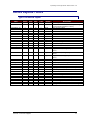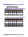
1
DATA INTEGRATION PROCEDURES IN SUPPORT OF STATEWIDE TRANSPORTATION MODELING AND PLANNING PROCESSES Final Report: Executive Summary Research Center Florida Department of Transportation 605 Suwannee Street, MS 30 Tallahassee, FL 32399-0450 Submitted by Ram M. Pendyala, Ph.D. Principal Investigator Department of Civil and Environmental Engineering University of South Florida, Tampa, FL 33620 In Collaboration with Geographic Data Technology Caliper Corporation URS Corporation Contract No. BC353, RPWO #20 2003 Acknowledgements The project team is grateful to the members of the Statewide Model Task Force for providing technical guidance and advice throughout the course of this research project. The project team thanks Robert G. McCullough, P.E., Huiwei Shen, and Vidya Mysore of the Systems Planning Office for their help in coordinating this research effort with other ongoing model development projects in the state. Disclaimer The contents of this report do not necessarily reflect the official views or policies of the Florida Department of Transportation or its constituent divisions. This report does not constitute a standard, specification, or regulation. BC353, RPWO#20: Data Integration Procedures in Support of Statewide… Page ii Executive Summary INTRODUCTION Planning and modeling processes at the local, regional, and statewide levels in the State of Florida rely on a wide variety of data sources for their inputs. For example, the various FSUTMS models used in the state and the FIHS Support System utilize an array of input variables that describe the socio-economic, demographic, transportation network, intermodal facility, pavement condition, characteristics of a region. accident, traffic volume, environmental, and land use All of these data items are derived from a variety of different sources and then pulled together to perform the desired analysis or run the appropriate model. Due to the disparity in the format and level of aggregation of the various databases from which desired input variables can be derived, the task of developing an integrated database for modeling and planning purposes is extremely time-consuming and arduous. Keeping a modeling or planning database constantly updated is another major challenge as the data sources from which variables are derived are often updated in different years. In addition, as different agencies employ different data extraction and integration procedures, there are inconsistencies across databases utilized for planning in the state. As the amount of data required to support planning and modeling processes in the state continues to increase and the number of data sources from which input variables need to be derived continues to rise, there is a need to develop a set of consistent data integration procedures that can support the modeling and planning processes in the state. These procedures would help state and local agencies in their planning efforts while ensuring consistency across databases and agencies. STUDY OBJECTIVES The specific objectives of the project were as follows: BC353, RPWO#20: Data Integration Procedures 1 1. To identify data items and data sources that are commonly used in the State of Florida for transportation planning and modeling 2. To develop data integration procedures that allow the extraction and integration of variables from a variety of sources, formats, and levels of aggregation 3. To provide a mechanism by which planning and modeling databases can be easily updated as key data sources (e.g., census) get updated. METHODOLOGY The Department proposed to develop and implement a comprehensive set of data integration procedures in support of modeling and planning processes in the State of Florida. The procedures would not only focus on the extraction and integration of data derived from a wide variety of disparate data sources, but also on the updating and verification of the databases over time. The project involved close coordination with several other ongoing research projects dealing with the integration of state-of-the-art methodologies into Florida’s statewide model, the development of urban and statewide freight models, and the development of conflation (data or network matching) tools. This project also included an extensive effort to coordinate closely with MPOs, state agencies, Districts, the Turnpike District, and the agencies responsible for compiling the data sources from which input variables are derived. This section provides an overall description of the tasks undertaken to accomplish the mission of the project. The project was divided into two main phases. The first phase focused on the development of data integration procedures while the second phase focused on the development of procedures for data updating and verification. The first phase involved the development of data integration procedures that allowed the extraction of data items from a variety of data sources. Within this phase, the data items that are used for modeling and planning in the State of Florida were identified and the relevant data sources from which these items may be extracted were recognized. The major activities undertaken in the first phase are as follows: Review of Current Practice: A comprehensive review of the state-of-the-practice in data integration was conducted. The review focused on methods for integrating and matching data BC353, RPWO#20: Data Integration Procedures 2 across disparate data sources that do not have the same format or level of aggregation. In addition, the research team communicated with District and MPO planning staff to find out current practice related to data integration and database compilation for all of the different types of transportation modeling and planning studies conducted by these agencies. Identification of Data Needs and Issues: In coordination with District planning staff and MPO planning staff, the research team identified data needs for planning and modeling applications in the state. Meetings were held with staff from various agencies in order to help compile an exhaustive list of data requirements in the state. In addition to identifying data needs, issues related to the availability and preferred format of the data were also discussed. Data needs and issues were identified from the perspective of different users and applications. For example, data requirements for regional and local FSUTMS models were different from those for the statewide FSUTMS model. Similarly, the FIHS support system had unique data requirements. Thus the identification of data needs and issues was done in association with the type of application or use of the data. Identification of Data Sources and Formats: Following the identification of data needs and issues, the research team focused on the identification of databases that serve as the best data sources for all of the variables used by planners and modelers in the state. For every variable or data item identified in the project, a suitable data source was identified. All of the attributes of the data sources have been compiled into the data integration procedures and programs developed in this project. For example, the attributes considered include, but are not necessarily limited to: ! Date of database ! Frequency of update ! Format ! Coding scheme ! Availability ! Cost ! Size of database ! Variables included in database ! Level of aggregation (spatial and temporal) ! Coverage BC353, RPWO#20: Data Integration Procedures 3 ! Completeness ! Accuracy and precision levels ! Other Development of a Data and Application Taxonomy: Prior to the development of data integration algorithms, the project team developed a data and application taxonomy or classification system. Such a system is needed because different algorithms have been developed for different types of data, modeling applications, and planning processes. For example, the types of data integration procedures that apply to transportation network data do not apply to socio-economic data (ZDATA). Similarly, the types of data integration procedures that apply to FSUTMS model development and application do not apply to the FIHS support system. Therefore, it was considered very important to develop a proper classification system which can be used to guide the development of data integration algorithms and procedures. In this way, a user can easily and conveniently use the right algorithm for the type of data and application that he or she is undertaking. This taxonomy was developed in collaboration with agency staff. Development of Data Integration Algorithms: Appropriate data integration algorithms were developed according to the taxonomy developed in the project. The algorithms and procedures developed in this project include a vast array of capabilities and cover the full range of applications and data types relevant to modeling and planning needs in the State of Florida. These algorithms and their associated databases and networks are provided on a set of 9 CD’s that accompany this report. The algorithms cover all data associated with the FIHS support system and FSUTMS models across the state. The data integration procedures contain appropriate data channelization methods in which a stream of data manipulations and adjustments are performed so that the data are extracted and integrated in a manner desired by planning and modeling applications in the state. The data integration procedures cover the entire process – from the source to final utilization. If the data are collected in the field (say, traffic counts), then the data integration algorithm works on the raw traffic count data that is collected in the field. It will run the data through a series of manipulations, adjustments, and transformations so that it is obtained in a form ready for final utilization. The algorithms operate on many possible sources of data including census, state and regional databases, FSUTMS data, FDOT RCI and TCI data, and FGDL data. BC353, RPWO#20: Data Integration Procedures 4 Development of Data Integration Tool Suite: All of the data integration algorithms and procedures developed in the project have been put together in the form of a computerized suite of tools that can be used by planners and modelers in the state. The suite of tools has been assembled in collaboration with agency staff who would constitute the end users of the product. Considering that most databases are now available in GIS format, the suite of tools has been developed so that a strong interface with ArcView is available for the user. The second phase of the project focused on the development of procedures for regularly updating and verifying the data derived from different data sources. As data sources are periodically updated, the transportation planning and modeling databases should be periodically updated as well. Also, the data need to be verified periodically to ensure that they are correct, the best data available, and up-to-date. Following the completion of Phase I, the research team developed procedures and algorithms that can be used by planners and modelers for periodically updating and verifying their databases. The major activities undertaken in this phase include: Protocols for Data Update and Verification: It was considered important to develop a set of protocols that will define the need for and the nature of the date update and verification process that a user would undertake. For example, if only one variable in a database of 100 variables has been found to be updated, is that justification to proceed with a database update procedure? If it is found that the level of accuracy of one variable in a database of 100 variables has been changed (in the source) by 0.01%, is that justification to proceed with a database verification and correction procedure? The research team worked closely with agency staff to develop a set of protocols that will help guide users with respect to the need for data update and verification. The protocols form a set of criteria against which users can check their data configuration and decide whether to proceed with a data update and verification procedure. Development of Data Update and Verification Algorithms: Procedures and algorithms that allow users to check their databases for updates and consistency and verify that their databases reflect the most accurate information available were developed. The algorithms and procedures incorporate the protocols and criteria developed in this project so that users can BC353, RPWO#20: Data Integration Procedures 5 decide on the types of updates and consistency checks to which they would like to subject their databases. Preparation of Computerized Suite of Tools: The procedures and algorithms developed in this project have been packaged into a suite of computerized tools that are interfaced with the ArcView GIS interface. The tools are available on a set of 9 CD’s that accompany this report. SAMPLE MODEL SYSTEM WITH BUILT-IN DATA INTEGRATION PROCEDURES AND UTILITIES The Broward custom sample application has been developed by Caliper Corporation and the instructions and documentation provided in this Executive Summary have been prepared by Caliper Corporation under a subcontract to the University of South Florida. The custom application performs the following transportation planning procedures: • Trip Generation • Highway and Transit Network skimming • Trip Distribution and the Highway Only Modules • Modal Split • Highway and Transit Trip Assignment This section describes how to setup scenarios, run the models, and view the output. The Addin allows one to store any number of scenarios. For example, one may want to have a Year 1999 Scenario and a Year 2025 Scenario. Scenarios are defined by a scenario name, a set of input files, output files, and model parameters, and there are special features in the Add-in to assist in setting up scenarios. Once a scenario has been setup, the model steps for a scenario can be run separately, run as a group, or run iteratively with feedback. There are three key dialog boxes that are used to manage and run the model. These are shown below. • The first is the main dialog box (called the Broward Planning Model dialog box), which is what appears when the Add-in is launched. From this dialog box, scenarios are selected and the models are run. BC353, RPWO#20: Data Integration Procedures 6 • The second dialog box is the Project Scenarios dialog box. This is invoked by clicking on the Setup button from the main dialog box. In this dialog box, the scenarios are managed. Here one can add, delete, sort, describe, and rename scenarios. Each scenario is defined by a set of input files, output files, and parameters. • The third dialog box is where one enters and views the detailed information regarding the scenario. This type of dialog box is launched by clicking the Contents button in the Project Scenarios dialog box. The parameter manager dialog box will provide information for the Scenario and model Step that are highlighted in the Project Scenario dialog box. From the parameter manager dialog box you can open input or output files, change input or output files, and view and change model parameters. The rest of this section explains how to work with these dialog boxes to setup and run the sample Broward model. Main Dialog Box Scenario Manager Input/Output File and Parameter Managers Installing the Add-in The custom Add-in is packaged in an easy-to-install setup program. Before installing the Add-in, one should delete all other previous versions of the Broward model that are installed on the BC353, RPWO#20: Data Integration Procedures 7 computer. The setup program is called setup.exe. It is located on the CD provided and should be run from within Windows. It will prompt the user for the directory in which TransCAD is located and a directory into which the data files are to be copied. This step only needs to be run only once (per computer). After it is installed, running the Add-in is as simple as running TransCAD. First, start TransCAD, then go to Tools-Add-ins and choose the Add-in entitled Broward Planning. Click on OK to invoke the custom interface. Computer Requirements The Broward model contains large matrices and files and requires a reasonably powerful PC machine in order to run efficiently. The research team recommends the following as minimum standards: • Pentium 700MHz • 128MB of RAM memory • Approximately 1 GB of free hard drive space per scenario to accommodate all input and output files Launching the Add-in Once the Add-in is installed using the steps described above, the main dialog box is launched through the Tools-Add-ins feature in TransCAD. ♦ To Launch the Add-in 1. If TransCAD is not running, launch TransCAD. 2. Choose Tools-Add-ins. 3. Choose Broward Planning and click OK to display the Broward Planning Model dialog box. (If you Broward Planning Model in the Add-ins window, click Cancel and INSTALL the Add-in by following the directions above.) All other functionality for the Add-in is accessed through this main dialog box. Working with the Year 1999 Base Scenario In this section, one will learn how to setup, run, and view outputs for the Year 1999 Base Scenario. BC353, RPWO#20: Data Integration Procedures 8 Setting up the Year 1999 Base Scenario Before one can run the model, one has to first define the scenario. This involves providing TransCAD the name of the scenario along with the set of input files, output files, and parameters that define the scenario. This information is entered and viewed using the Project Scenarios and Parameter Manager dialog boxes. One can store any number of scenarios in the custom Add-in. The Year 1999 Base Scenario is particularly straightforward to setup, because it is the default scenario provided with the custom Add-in (as defined in the BRWD_MOD.ASC file installed with the Add-in). ♦ To Setup the Year 1999 Base Scenario 1. If the Add-in is not launched, launch it by following the instructions above to open the Broward Planning Model dialog box. 2. From the Broward Planning Model dialog box, click on the Setup button to open the Project Scenarios dialog box. If there are no existing scenario files, the Custom Add-in will ask if a new one is to be created; click yes. 3. Click the Add button to add a new scenario. A scenario named New Scen is automatically created and added to the list of scenarios in the text box at the top of the Project Scenarios dialog box, and the current time is also listed. By default, New Scen is the Year 1999 Base Scenario. The input and output files as well as the parameters are automatically entered, and the model is ready to run. Note that if a user is setting up any Scenario other than the base scenario, then he/she will have to modify at least some of the input files and parameters to match the scenario of interest. This is described later in the section on Working with Additional Scenarios. 4. Rename the scenario to something more descriptive by entering the new name in the Name text box (for example, Year 1999 Base Scenario), and, if desired, provide a longer description of the scenario in the Description text box. BC353, RPWO#20: Data Integration Procedures 9 5. Click OK to save the settings of the scenario and close the Project Scenarios dialog box. Now the base scenario is setup and ready to run. Note that the model steps are listed in the Steps text box and the directory listed for the scenario is the location to which the installation program installed the input and output files. If one wants to view or modify any of the scenario settings (input/output files or parameters), one can do so by clicking on the Contents button (described under Viewing Outputs... and Modifying Scenarios). Running the Year 1999 Base Scenario Models are run from the Broward Model Model dialog box. Be sure to exit the Project Scenarios dialog box (by clicking OK) so that the settings for the scenario are updated and saved. Any scenario can be run either with the full model, with the Highway-Only Model, or one model step at a time. ♦ To Run the Year 1999 Base Scenario with the Full Model 1. From the Broward Planning Model dialog box, choose the Year 1999 Base Scenario from the Scenarios selection box. (If you have not yet created the year 1999 base scenario, do so by following the instructions above.) 2. Make sure that the Highway Only checkbox is unchecked. 3. Uncheck the Stop after stage checkbox. BC353, RPWO#20: Data Integration Procedures 10 4. Make sure that the Run all steps checkbox is checked. 5. Click the Initialization button. The custom Add-in will first run all model steps from Initialization through Assignment. ♦ To Run all of the Model Steps for the Year 1999 Base Scenario with the HighwayOnly Model 1. From the Broward Planning Model dialog box, choose the Year 1999 Base Scenario from the Scenarios selection box. (If you have not yet created the year 1999 base scenario, do so by following the instructions above.) 2. Make sure that the Highway Only checkbox is checked. 3. Uncheck the Stop after stage checkbox. 4. Make sure that the Run all steps checkbox is checked. 5. Click the Initialization button. The custom Add-in will run only the steps associated with the higway-only model. ♦ To Run a Single Model Step of Year 1999 Base Scenario 1. From the Broward Planning Model dialog box choose the Year 1999 Base Scenario from the Scenarios selection box. 2. Make sure that the Stop after stage checkbox is checked. 3. Make sure that the Run all steps checkbox is checked. 4. Make sure that the input files necessary for the model you want to run are available. (The easiest way to do this for the base scenario is to run each of the prior stages of the model by following these steps.) 5. Click the button that states the step you want to run (for example, Modal Split). The custom Add-in will run just that stage and stop. Viewing and Analyzing Outputs for the Year 1999 Base Scenario The full functionality of TransCAD is available to analyze the outputs of a model run. There are innumerable ways to perform the analysis. Below are a few suggestions to get started viewing the output results. For more information, see the TransCAD User’s Guide and Travel Demand Modeling with TransCAD manual. BC353, RPWO#20: Data Integration Procedures 11 ♦ To Open the Output (or Input) Files for any Model Step If the name and location of the output file are known (information for the base year scenario is provided in the Model Documentation manual), one can always choose File-Open in the TransCAD menu, choose the file type to view (Geographic File, Dbase table, Matrix, etc.) and choose the file to be opened. Alternatively, one can open the files from the Parameter manager dialog box of the Add-in. To use this approach: 1. Click the Setup button in the Broward Planning Model main dialog box to open the Project Scenarios dialog box. 2. Select the Scenario and model Step of Interest. 3. Click the Contents button to open the Parameter Manager dialog box. 4. Click the Output radio button to get the list of output files. BC353, RPWO#20: Data Integration Procedures 12 5. Select the files that you want to open (use Shift-click or Ctrl-click to select multiple files). 6. Click the Open button and the Add-in will open the files into TransCAD. Note that when the Parameter manager dialog box is open, one can change the step or the scenario that is displayed in the dialog box by making the selection in the Project Scenario dialog box. There are many files that play a role in several of the model steps. For example, Modal Split produces an OD flow matrix as an output, which is an input to Assignment. However, note that each file appears only once in the entire set of Parameter Manager dialog boxes, usually in the first model step for which it is used. ♦ To Generate and View the Trip Length Distribution (TLD) Open the Hwy CG Skim Mat matrix and the HBW Trip Mat located in the Trip Distribution Output Files: 1. Use the steps described above to open the HBW Trip Mat, which is an output from the Trip Distribution step, and the Hwy CG Skim Mat, which is an output to the Trip Distribution step. Generate the Trip Length Distribution: 2. From the TransCAD menu, choose Planning-Planning Utilities-Trip Length Distribution to display the Trip Length Distribution dialog box. 3. Select the OD Matrix as the Base Matrix File, the Shortest Path Matrix as the Impedance Matrix File. 4. Click the Options button and enter a bin starting point of 0, an ending point of 60, and bin sizes of 5. Click OK. 5. Click OK and enter the name for the output TLD matrix, and click OK to generate the matrix. TransCAD generates the TLD matrix and shows a Results Summary dialog box. Click Show Report to view summary statistics such as minimum, maximum, and average trip lengths. Otherwise Click Close to view the TLD matrix. To generate a chart of the TLD: 6. Highlight the Percent column in the TLD matrix. BC353, RPWO#20: Data Integration Procedures 13 7. Choose File-New to display the New File dialog box. Choose Chart and click OK to open the Matrix Chart Data dialog box. 8. Click OK (to chart the Selected Cells) to display the Chart Properties dialog box. 9. Choose a bar chart and click OK. TransCAD displays a chart of the TLD. ♦ To View Highway Volume Outputs for the PM Peak Period Open the highway geography and highway flow table: 1. Use the steps described above to open the Highway DB file, which is an input to the Initialization model step, and the Hwy Car Flow Table, which is an output of the Assignment step. Join the highway geography to the flow table: 2. From the TransCAD menu, choose Dataview-Join and join the HNET layer’s ID field to flow HRLDXY’s ID1 field. Click OK to view the join. Generate a flow map: 3. Choose Planning-Planning Utilities-Create Flow Map to create both a size theme on the links based on volume flow and a color theme based on VOC ratio. Use the utilities in TransCAD to move about the map, add labels, etc. ♦ To View the Running Log and Report Files Each time a model is run, the Add-in will save information on the run in two text files, the log file and the report file. The log file lists every procedure that was run and any warnings that were encountered. The report file lists every procedure that has been run. It also lists all of the input data that was used for the procedure. To view these files: 1. Choose Edit-Preferences from the TransCAD menu to open the Preferences dialog box. 2. Choose the Logging tab. 3. Click on the Display button to display either the log file or the report file. Information on the most recent model run will be at the end of these files. BC353, RPWO#20: Data Integration Procedures 14 Working with Additional Scenarios Any number of scenarios beyond the Year 1999 Base Scenario can be setup, stored, and run using the Add-in. Adding a Scenario ♦ To Create an Additional Scenario 1. From the Broward Planning Model dialog box, click on the Setup button to open the Project Scenarios dialog box. 2. Click the Add button to add a new scenario. The Add-in will create a scenario named New Scen and add it (along with the current date and time) to the end of the list of scenarios in the dialog box. 3. Rename the scenario using the Name text box. 4. Enter a description for the scenario in the Description text box. By default, the added scenario is created using the settings for the default Year 1999 Base Scenario, and so you will have to re-specify at least some of these settings to generate the scenario of interest. The next step describes how to do this. Modifying Scenarios A scenario is defined by the set of input files, output files, and parameters for which the model is to be run. Each step of the model has a different set of files and parameters. These settings are managed using the Parameter manager dialog boxes, for which there is a different dialog box for each model step. An important point in selecting the input files to use for a given scenario is that these files must match the input files provided for the default Year 1999 Base Scenario. This means that: • All table inputs (Demographics table, trip rates table, etc.) must contain the same field names as the original default files and must have the same number of records. However, note that you can use any of the following formats for the tables: DBASE, Comma Delimited ASCII, Fixed Format ASCII and Fixed Format Binary • Matrices must contain the Ids of the Broward centroid nodes found on the node layer of the highway database (Ids 1-933). Currently, there are 933 such nodes. BC353, RPWO#20: Data Integration Procedures 15 If any of these restrictions are violated, the Add-in will give you error messages if you attempt to run the model. ♦ To Modify the Input Files, Output Files, or Parameters Used for a Scenario 1. From the Project Scenarios dialog box, select the scenario of interest from the list of scenarios and the model step of interest from the Steps selection box. 2. Click the Contents button to open the Parameters manager dialog box for the chosen scenario and model step. This dialog box will automatically update to reflect the selections in the Project Scenarios dialog box. So to view a different model step or scenario, simply make the selections in the Project Scenarios dialog box. Only one Parameter manager dialog box can be viewed at a time. 3. Use this dialog box to manage the input and output files as follows To do this… Do this… View the list of input files Click the Input radio button, and all input files for the model step will be displayed in the Files scroll list. View the list of output files Click the Output radio button, and all output files for the step will be displayed in the Files scroll list. Obtain a description of the file Select the file of interest from the Files scroll list, and a description will be provided in the Help text box. Check the status of a file The Status column in the Files scroll list states whether a file Exists, is In Use, or is Missing. BC353, RPWO#20: Data Integration Procedures 16 In Use files will be automatically closed when a model is run. All of the input files must Exist in order for a model to be run. Any output files that Exist will be overwritten when a model is run. Open a file Either double click on the file in the Files scroll list, or select the file in the Files scroll list and Click the Open button. Networks (.NET) and transit networks (.TNW) cannot be opened, but their geographic counterparts (.DBD line geographic files and .RTS route systems) can. Change the file that is used Select the file you want to change from the Files scroll list. Click on File and select the file that you want to use. All input files must match the structure of the input files provided with the Year 1999 Base Scenario Change the directory of a file To change the directory of a file, select it from the Files scroll list, click on Dir and select the directory. To change the directory for multiple files, use Shift-click or Ctrl-click to select multiple files from the Files scroll list. 4. Use this dialog box to manage the parameters as follows To do this… Do this… View scalar parameters Click the Scalar radio button and the scalar parameters will be listed in the Parameters scroll list. View List (Vector) parameters Click the List radio button and any parameter lists will be displayed in the left Parameters scroll list. Click on a parameter list and the parameters that make up the list will be displayed in the right Parameters scroll list. Obtain a description of the Parameter Select a parameter from the Parameters scroll list, and a description will be provided in the Help text box. Change the parameter Select the parameter from the Parameters scroll list and enter the value of the parameter in the text box. BC353, RPWO#20: Data Integration Procedures 17 Managing Scenarios Any number of scenarios can be stored in the Add-in. Scenarios can be added, deleted, and modified at will. ♦ To Manage the Scenarios 1. From the Broward Planning Model dialog box, click the Setup button to open the Project Scenarios dialog box. 2. Use this dialog box to manage the scenarios as follows To do this… Do this… Add a new scenario Click the Add button and a scenario named New Scen will be added to the bottom of the list of scenarios along with a time stamp. This scenario will, by default, be setup with the Year 1999 Base Scenario settings. Delete a scenario Select the scenario you want to delete from the Scenario scroll list, and click the Delete button. Sort the scenarios by date Click the Sort by Date button. Sort the scenarios by name Click the Sort by Name button. Move a scenario up or down Select the scenario you want to move up in the scenario list and click the Move Up or Move Down button. Rename a scenario Select the scenario you want to rename and enter the new name in the Name text box. Change the default directory Select the scenario for which you want to change the default directory for the input and output files, click the Dir button and select the directory. The directory for all input and output files for the scenario will be changed to this default directory. BC353, RPWO#20: Data Integration Procedures 18 Provide a description Select the scenario for which you want to provide a description, and enter the description in the Description text box. Save scenario settings Click OK. Running a Scenario Running a scenario is no different than running the Year 1999 Base Scenario. However, the key to running a scenario that is not the default is to verify that the inputs are setup correctly. This means that all input files must exist, and they must have the same format as the default input files, as described above in Modifying Scenarios. Another important point is that all existing Output files will be overwritten when the model is run. ♦ To Run a Scenario 1. Scenarios are run from the Broward Planning Model dialog box: BC353, RPWO#20: Data Integration Procedures 19 2. Select the scenario you want to run from the list of scenarios, and use this dialog box to run models as follows: To do this… Do this… Run a model with Feedback Click the Feedback Model button. Run a model without Feedback Uncheck Stop after stage, check Run all steps, click the Initialization button. Run one model step Verify that all inputs for the model step exist. Check Stop after stage, check Run all steps, and click the button that states the model step you want to run. Skip a model step Click on the picture button next to the step you want to skip to open the Stage Step Settings dialog box. Uncheck any step you do not want to run and click OK. The Run all steps checkbox will automatically be unchecked. View/modify scenario settings Click Setup to open the Project Scenarios dialog box, and follow instructions above regarding setting up scenarios. Exit the Add-in Click Quit Viewing and Analyzing Outputs from a Scenario Once the model is run, you can use all of the functionality in TransCAD to view and analyze results. There are innumerable ways to perform the analysis. Examples of such analysis were provided under the heading of Viewing and Analyzing Outputs of the Year 1999 Base Year Scenario. For more information, see the TransCAD User’s Guide and Travel Demand Modeling with TransCAD manual. In summary, this research project has resulted in the development of a suite of data integration tools and procedures that can be used to support statewide transportation modeling and planning processes in the state. This executive summary provided a brief overview of the methodology adopted by the research team and the sample model system that illustrates the data integration procedures. The sample model system has been developed in a TransCAD format consistent with the new modeling directions in the State of Florida. Users should refer to the TransCAD documentation and other documents provided on the CD’s for detailed instructions on the use of the procedures and software. BC353, RPWO#20: Data Integration Procedures 20 In addition to developing a suite of data integration tools and procedures consistent with the TransCAD format, the research team also worked with Geographic Data Technology, Inc. to develop highway network systems that can serve as a reference for transportation modeling networks in the state. The Appendix section provides a small extract of the documentation for the GDT highway networks. Full documentation is available on the CD’s accompanying this report. BC353, RPWO#20: Data Integration Procedures 21 Dynamap/Transportation Transactions 3.0 Introduction 1 Inside This Section: • Section 1: Introduction Description 3 Dynamap/Transportation Transactions 3.0 Description The Dynamap/Transportation Transaction product provides customers with GDT’s most current data editing work in an efficient monthly deliverable. Transaction files only include information on data changes since the previous versions and allow the customer to have the most up-to-date data without reloading the entire Dynamap/Transportation product every quarter. Transactions are designed for users that take advantage of RDBMS or database-like methods of storing geographic data. Dynamap/ Transportation Transactions are delivered monthly and are tiled by state. Transactions are applied serially from the January release of product and are not guaranteed to line up with standard product at quarterly releases. Section 1: Introduction 4 Dynamap/Transportation Transactions 3.0 Getting Started 2 Inside This Section: • What's In This Package? • Currentness, Datum, Projection, Precision • Transactions Concepts • Directory and File Naming Conventions • Copyright File Section 2: Getting Started 5 Dynamap/Transportation Transactions 3.0 What's In This Package? With your shipment of the Dynamap/Transportation Transactions Version 3.0 you should have received, in addition to this manual: • Dynamap/Transportation Transactions on the correct media (CD-ROM, cartridge, or diskette). • Packing Slip (paper or electronic listing of package contents) • Documentation CD Check now to be sure that you have received the correct order. NOTE: For a full discussion of the files you have received, see "Directory and File Naming Conventions" in this section. Format Dynamap/ Transportation Transactions is available in the following formats: Fixed-length ASCII format with line feeds ArcSDE-Loadable format Currentness, Datum, Projection, Precision Transactions are provided in NAD 83, geographic projection using decimal degrees to six digits of precision. The only exception is Hawaii, which is in the Old Hawaiian Datum. Every tile of Dynamap/Transportation transactions will include a transaction currency file that includes currency information both in the file as well as the filename. This text file will include: the month and year of the transaction, the product to which it applies, and a series to indicate the order in which the file needs to be applied to the base product. Section 2: Getting Started 6 Dynamap/Transportation Transactions 3.0 The following is an example of the transaction currency file: DYNAMAP/TRANSPORTATION V4.0 TRANSACTION FILE January 2002 SERIES 1 (Series 2 = February; Series 3 = March, etc.) Transactions Concepts Transportation Transactions are for streets only. Add An add transaction is one that generates a new Dynamap-ID. This can include a brand-new feature, a feature whose nodes have been moved, or a feature split into two or more features. Add transactions are often accompanied by delete transactions to represent a feature edit not covered by change transactions. Change Change transactions alter the data, but do not generate a new Dynamap-ID. Circumstances that prompt a change transaction are attribute editing and shape point (not node) editing. Delete A delete transaction is one that deletes a DynamapID. Such operations can signify that a feature has been removed completely or has been replaced by another feature or features. Section 2: Getting Started 7 Dynamap/Transportation Transactions 3.0 Directory and File Naming Conventions When you receive your files, you can identify the file contents by understanding our directory structure and file naming conventions. Dynamap Transportation Transaction files are found in the following directory structure: State Tiled Data (ASCII format): \usa \st stxxxxst.da1 stxxxxst.da2 stxxxxst.da4 stxxxxst.da5 stxxxxst.dc1 stxxxxst.dc2 stxxxxst.dc4 stxxxxst.dc5 stxxxxst ddd stxxxxsf dax stxxxxsf dcx datum.txt cpyright.dxx trfilemm.dxx Street Record Type 1 Add Street Record Type 2 Add Street Record Type 4 Add Street Record Type 5 Add Street Record Type 1 Change Street Record Type 2 Change Street Record Type 4 Change Street Record Type 5 Change Street Record Type D Delete Street FIPS info Add Street FIPS info Change State Tiled Data (ArcSDE-Loadable format): \usa \st stxstmma.sde stxstmmc.sde stxstmmd.sde datum.txt cpyright.dxx trfilemm.dxx Street Add Street Change Street Delete where Transaction currency description file st = Two character state abbreviation; mm= Month of transaction from 01 - 12 x – filler character d – Delimiter l t x Section 2: Getting Started Transaction currency description file LF CRLF None 8 Dynamap/Transportation Transactions 3.0 Copyright File The copyright file included with this product is one of the following File name cpyright.txx cpyright.lxx cpyright.xxx cpyright.txt st 1 character of extension: t=carriage return/line feed l=line feed x=no delimiter nd 2 rd and 3 characters of extension: xx=fillers xx=fillers xx=fillers text file and contains the following text: The material contained herein includes proprietary and copyrighted data of Geographic Data Technology, Inc. (GDT), Lebanon, NH 03766-1445. Telephone: 800-331-7881. Copyright (C) 1984-2002. All rights reserved. Use is governed by applicable license agreement. Unauthorized duplication or use is prohibited. Section 2: Getting Started 9 Dynamap/Transportation Transactions 3.0 Record Layout 3 Inside This Section: • Record Layouts – ASCII • Record Layouts – ArcSDE-Loadable Section 3: Record Layout 10 Dynamap/Transportation Transactions 3.0 Record Layouts – ASCII Type 1 File Record Layout Field RT VERSION Start 1 2 End 1 5 Size 1 4 Type C C DYNAMAP_ID FEDIRP FENAME FETYP FEDIRS FCC FRADDL TOADDL FRADDR TOADDR POSTAL_L POSTAL_R FRLONG 6 16 18 48 54 56 59 70 81 92 103 108 113 15 17 47 53 55 58 69 80 91 102 107 112 122 10 2 30 6 2 3 11 11 11 11 5 5 10 C C C C C C C C C C C C C Right Left Left Left Left Full Right Right Right Right Left Left Right FRLAT 123 131 9 C Right TOLONG 132 141 10 C Right TOLAT ACC NAME_TYPE SHIELD HWY_NUM LENGTH SPEED ONE_WAY F_ZLEV T ZLEV FT COST TF COST FT DIR TF DIR NAME FLAG DELIMITER 142 151 152 153 154 159 167 170 172 174 176 184 192 194 196 150 151 152 153 158 166 169 171 173 175 183 191 193 195 198 9 1 1 1 5 8 3 2 2 2 8 8 2 2 3 1/2 C C C C C C C C C C C C C C C Right Full Full Full Right Right R Full Full Full Full Full Left Left Right Full Section 3: Record Layout Justify Full Full Description Record Type (Value "1") Four character internal GDT code representing year and month of database currency GDT Record Number Feature Direction, Prefix Feature Name Feature Type Feature Direction Suffix Feature Class Code From Address Left To Address Left From Address Right To Address Right Postal Code (ZIP or FSA) Left Postal Code (ZIP or FSA) Right Longitude From (leading –, implied 6 decimal places) Latitude From (leading +, implied 6 decimal places) Longitude To (leading –, implied 6 decimal places) Latitude To (leading +, implied 6 decimal places) Artery Classification Code (“1”, “2”, “3”, “4”) “R” (always PRN for this product) “I”, “U”, “S”, or blank #, # with letter, or blank (if SHIELD is filled) Seg length in miles, (implied 4 decimal places) Speed in mph (US) "FT", "TF", or "" Functional From segment-end elevation Functional To segment-end elevation From-to travel time (minutes, implied 5 decimal To-from travel time (minutes, implied 5 decimal From-to navigational direction To-from navigational direction Name metadata flag Carriage return/line feed, line feed or nothing 11 Dynamap/Transportation Transactions 3.0 Type 2 File Record Layout Field RT VERSION DYNAMAP_ID RTSQ LONG1 LAT1 LONG2 LAT2 LONG3 LAT3 LONG4 LAT4 LONG5 LAT5 LONG6 LAT6 LONG7 LAT7 LONG8 LAT8 LONG9 LAT9 LONG10 LAT10 DELIMITER Start 1 2 End 1 5 Size 1 4 Type C C 6 16 19 29 38 48 38 48 38 48 38 48 38 48 38 48 38 48 38 48 57 66 15 18 28 37 47 56 47 56 47 56 47 56 47 56 47 56 47 56 47 56 65 74 10 3 10 9 10 9 10 9 10 9 10 9 10 9 10 9 10 9 10 9 10 9 ½ C C C C C C C C C C C C C C C C C C C C C C C Justify Full Full Right Right Right Right Right Right Right Right Right Right Right Right Right Right Right Right Right Right Right Right Right Full Description Record Type (value "2") Four character internal GDT code representing year and month of database currency GDT Record Number Record Sequence Number Point 1, Longitude (-) Point 1, Latitude (+) Point 2, Longitude (-) Point 2, Latitude (+) Point 3, Longitude (-) Point 3, Latitude (+) Point 2, Longitude (-) Point 2, Latitude (+) Point 2, Longitude (-) Point 2, Latitude (+) Point 2, Longitude (-) Point 2, Latitude (+) Point 2, Longitude (-) Point 2, Latitude (+) Point 2, Longitude (-) Point 2, Latitude (+) Point 2, Longitude (-) Point 2, Latitude (+) Point 10, Longitude (-) Point 10, Latitude (+) Carriage return/line feed, line feed or nothing Type 4 File Record Layout Field RT VERSION DYNAMAP_ID RTSQ NAME_ID NAME_TYPE SHIELD HWY_NUM FT DIR TF DIR NAME FLAG DELIMITER Start 1 2 End 1 5 Size 1 4 Type C C 6 16 19 27 28 29 34 36 38 15 18 26 27 28 33 35 37 40 10 3 8 1 1 5 2 2 3 1/2 C C C C C C C C C C Section 3: Record Layout Justify Full Full Right Right Right Full Full Right Left Left Right Description Record Type (value "4") Four character internal GDT code representing year and month of database currency GDT nationwide unique segment ID Record Sequence Number Alternate Feature Name ID Alternate Feature Name Type “I”, “U”, “S”, “A”, “T” or blank #, # with letter, or blank From-to navigational direction To-from navigational direction Name metadata flag Carriage Return/Line Feed, Line Feed or 12 Dynamap/Transportation Transactions 3.0 Type 5 File Record Layout Field RT STATE COUNTY NAME_ID FEDIRP FENAME FETYP FEDIRS DELIMITER Start 1 2 4 7 15 17 47 53 End 1 3 6 14 16 46 52 55 Size 1 2 3 8 2 30 6 2 1/2 Type C C C C C C C C C Justify Full Full Full Right Left Left Left Left Description Record Type (value "5") FIPS State Code for File* FIPS County Code for File* Alternate Feature Name ID Feature Direction, Prefix Feature Name Street Type Feature Direction, Suffix Carriage Return/Line Feed, Line Feed or Nothing *FIPS codes taken from the left segment Street FIPS Information (feature type ‘A’ only) Field DYNAMAP_ID STATE00_L STATE00_R COUNTY00_L COUNTY00_R MCD00_L MCD00_R PLACE00_L PLACE00_R Size 10 2 2 3 3 5 5 5 5 Type C C C C C C C C C Justify r l f f r f f f f Fill sp sp Description GDT nationwide unique segment ID 2000 state FIPS left 2000 state FIPS right 2000 county FIPS left 2000 county FIPS right 2000 FIPS MCD/CCD left 2000 FIPS MCD/CCD right 2000 FIPS Place left 2000 FIPS Place right Type D (deletion) File Record Layout Field RECNUM Start 1 End 10 Size 10 Section 3: Record Layout Type C Description GDT Record Number 13 Dynamap/Transportation Transactions 3.0 Record Layout - ArcSDE-Loadable Item Name BUS_FID DYNAMAP_ID L_F_ADD L_T_ADD R_F_ADD R_T_ADD PREFIX NAME TYPE SUFFIX FCC POSTAL_L POSTAL_R ACC NAME_TYPE SHIELD HWY_NUM SEG_LEN SPEED ONE_WAY F_ZLEV T_ZLEV FT_COST TF_ COST FT_DIR TF_DIR NAME_FLAG ALT1_PREFIX ALT1_NAME ALT1_TYPE ALT1_SUFFIX ALT1_NAME_TYPE ALT1_SHIELD ALT1_HWY_NUM ALT1_FT_DIR ALT1_TF_DIR ALT1_NAME_FLAG ALT2_PREFIX ALT2_NAME ALT2_TYPE ALT2_SUFFIX ALT2_NAME_TYPE ALT2_SHIELD ALT2_HWY_NUM ALT2_FT_DIR ALT2_TF_DIR Section 3: Record Layout Type L I C C C C C C C C C C C C C C C D I C I I D D C C I C C C C C C C C C I C C C C C C C C C Width 10 11 11 11 11 2 40 6 2 3 5 5 1 1 1 5 8 3 2 2 2 10 10 2 2 3 2 40 6 2 1 1 5 2 2 3 2 40 6 2 1 1 5 2 2 Dec. 4 6 6 Description Spatial information storage Unique NorAm record number Left from address Left to address Right from address Right to address Street prefix Street name Street type Feature direction suffix Feature Class Code Postal code (ZIP or FSA) left Postal code (ZIP or FSA) right Artery Classification Code “R” (always PRN for this product) “T”, “I”, “U”, “S”, “A”, or blank #, # with letter, or blank Segment length in miles Speed in miles per hour One-way indicator From node elevation To node elevation From-To impedance in minutes To-From impedance in minutes From-To navigation direction To-From navigation direction Name metadata flag Street prefix Street name Street type Feature direction suffix “G” or blank “T”, “I”, “U”, “S”, “A”, or blank #, # with letter, or blank From-To navigation direction To-From navigation direction Name metadata flag Street prefix Street name Street type Feature direction suffix “G” or blank “T”, “I”, “U”, “S”, “A”, or blank #, # with letter, or blank From-To navigation direction To-From navigation direction 14 Dynamap/Transportation Transactions 3.0 ALT2_NAME_FLAG ALT3_PREFIX ALT3_NAME ALT3_TYPE ALT3_SUFFIX ALT3_NAME_TYPE ALT3_SHIELD ALT3_HWY_NUM ALT3_FT_DIR ALT3_TF_DIR ALT3_NAME_FLAG ALT4_PREFIX ALT4_NAME ALT4_TYPE ALT4_SUFFIX ALT4_NAME_TYPE ALT4_SHIELD ALT4_HWY_NUM ALT4_FT_DIR ALT4_TF_DIR ALT4_NAME_FLAG ALT5_PREFIX ALT5_NAME ALT5_TYPE ALT5_SUFFIX ALT5_NAME_TYPE ALT5_SHIELD ALT5_HWY_NUM ALT5_FT_DIR ALT5_TF_DIR ALT5_NAME_FLAG STATE00_L STATE00_R COUNTY00_L COUNTY00_R MCD00_L MCD00_R PLACE00_L PLACE00_R Section 3: Record Layout I C C C C C C C C C I C C C C C C C C C I C C C C C C C C C I C C C C C C C C 3 2 40 6 2 1 1 5 2 2 3 2 40 6 2 1 1 5 2 2 3 2 40 6 2 1 1 5 2 2 3 2 2 3 3 5 5 5 5 Name metadata flag Street prefix Street name Street type Feature direction suffix “G” or blank “T”, “I”, “U”, “S”, “A”, or blank #, # with letter, or blank From-To navigation direction To-From navigation direction Name metadata flag Street prefix Street name Street type Feature direction suffix “G” or blank “T”, “I”, “U”, “S”, “A”, or blank #, # with letter, or blank From-To navigation direction To-From navigation direction Name metadata flag Street prefix Street name Street type Feature direction suffix “G” or blank “T”, “I”, “U”, “S”, “A”, or blank #, # with letter, or blank From-To navigation direction To-From navigation direction Name metadata flag 2000 state FIPS left 2000 state FIPS right 2000 county FIPS left 2000 county FIPS right 2000 FIPS MCD/CCD left 2000 FIPS MCD/CCD right 2000 FIPS Place left 2000 FIPS Place right 15 Dynamap/Census Boundaries 4.x Introduction 1 In This Section: • Section 1: Introduction About Census Boundary Files 3 Dynamap/Census Boundaries 4.x About Census Boundary Files Census Boundaries are a set of boundary and inventory files representing seven different levels of Census geography: State, County, Tract, Block Group, Block, Place, and MCD. The data included in these files was extracted from Census TIGER 2000 data. Latitude/Longitude Data DIME files are unsigned and have 6 implied decimal places. Northern latitudes are positive (0° to 90°), southern latitudes are negative (0° to -90°). West longitudes (including most of the USA) are negative (0° to -180°). Projection This product is delivered in Geographic projection. Section 1: Introduction 4 Dynamap/Census Boundaries 4.x All coordinates are referenced to NAD83 except for Hawaii state tile, which is in the old Hawaiian datum. Hawaii in the nation tile is NAD83. Generalization These boundaries have been generalized to 30,000 points per polygon for MapInfo format only. Every boundary has as many points as are required to draw its shape accurately. Water Internal water features are not included in the Census boundary products. The exceptions are some shoreline water features in areas "without shoreline buffer." See below for additional details. All states that are bounded by the Atlantic Ocean, The Gulf of Mexico, The Pacific Ocean and The Great Lakes will have two sets of boundaries for those areas that extend out into the water: • The first set of boundaries will follow the shoreline and will not extend into the ocean or lake. These boundaries are referred to as "without shoreline buffer". • The second set of boundaries will extend to the political boundary of the state. These boundaries are referred to as "with shoreline buffer". The coastal extreme of a database is represented by the political boundary or 12-mile limit. Note that extensions into water are included in area calculations. Centroids for multi-polygon features are generated for the largest polygon in the feature and all centroids are internal to that polygon. Centroids of buffered polygons may be located over water within the 12mile limit. Centroids of non-buffered features will always be on the land side of the shoreline. Section 1: Introduction 5 Dynamap/Census Boundaries 4.x Getting Started 2 In This Section: • What’s In This Package • Directory Structure • Copyright File Section 2: Getting Started 6 Dynamap/Census Boundaries 4.x What's In This Package? With your shipment of the Dynamap/Census Boundary Files you should have received, in addition to this manual: • Dynamap/Census Boundary Files on the correct media in the correct format. • Packing Slip (printed or electronic list of package contents) • Documentation CD Check now to be sure that you have received the correct order. For information on the installation of these files see the GDT Data Installation manual included on the Documentation CD sent with your order. Section 2: Getting Started 7 Dynamap/Census Boundaries 4.x Directory Structure When you receive your files, you can identify the file contents by understanding our directory structure. Ungeneralized boundaries come in nationwide or state directories with product subdirectories. Product files are identified by the state abbreviation or state FIPS, depending on format. Note: Census Blocks are available tiled by county only. Copyright File The copyright file included with this product is one of the following: File name cpyright.txx cpyright.lxx cpyright.xxx cpyright.txt st 1 character of extension: t=carriage return/line feed l=line feed x=no delimiter nd 2 rd and 3 characters of extension: xx=fillers xx=fillers xx=fillers text file and contains the following text: The material contained herein includes proprietary and copyrighted data of Geographic Data Technology, Inc. (GDT), Lebanon, NH 03766-1445. Telephone: 800-331-7881. Copyright (C) 1984-2002. All rights reserved. Use is governed by applicable license agreement. Unauthorized duplication or use is prohibited. Section 2: Getting Started 8 Dynamap/Census Boundaries 4.x ArcInfo Format 3 In This Section: • Introduction • Directories and Files • Record Layouts Section 3: ArcInfo Format 9 Dynamap/Census Boundaries 4.x Introduction Versions Supported Dynamap/Census Boundary files in ArcInfo format are intended for the following versions of ArcInfo software: ArcInfo 7.x and higher Precision ArcInfo format products come in double precision for use with workstation or mainframe ArcInfo. Precision refers to the number of bits (single - 32 vs double - 64) used to store coordinate data, and is an inherent hardware limitation. Coverages in double precision are slightly more accurate, but also larger. Native Format ArcInfo coverages are shipped in native format (unEXPORTed) ready for use, and do not need to be processed in any way. ArcInfo coverages are spatially indexed. Shoreline Boundaries All states that are bounded by the Atlantic Ocean, The Gulf of Mexico, The Pacific Ocean or the Great Lakes will have two sets of boundary files. One set will follow the shoreline and will not extend into the ocean or lake. The second set will extend to the political boundary of the state. Section 3: ArcInfo Format 10 Dynamap/Census Boundaries 4.x Directories and Files Directory Structure Arc/Info files are placed in the following directory structure: Notes: SS = State FIPS; CCC = County FIPS Nationwide Tiles usa/ usa/state/ usa/county/ usa/place/ usa/mcd/ Copyright file, genus.txt, dynaname.txx, datum.txt* Nationwide State boundary and inventory Nationwide County boundary and inventory Nationwide Place boundary and inventory Nationwide MCD boundary and inventory State Tiles usa/ usa/SS/ usa/SS/state usa/SS/county usa/SS/tract usa/SS/blk_grp usa/SS/place usa/SS/mcd dynaname.txx Copyright file, genf<stfips>.txt, datum.txt* State level State boundary and inventory State level County boundary and inventory State level Tract boundary and inventory State level Block Group boundary and inventory State level Place boundary and inventory State level MCD boundary and inventory County Tiles usa/ usa/SS/ usa/SS/SSCCC/ usa/SS/SSCCC/block dynaname.txx genf<stfips>.txt Copyright file, Datum.txt* County level Block boundary and inventory * Datum.txt should also be located in all other directories that contain data Additional Files • A standard GDT Copyright file will be placed in the product file directory • Dynaname.txx file will be placed in the usa directory. Note: dynaname.txx has a crlf in it. • Datum.txt will be placed in the product file directory. This file contains the datum of the tile (NAD83 or OLD HAWAIIAN DATUM). Record length is always 100+CRLF. Section 3: ArcInfo Format 11 Dynamap/Census Boundaries 4.x File Names: ARCINFO COVERAGE WITH AND WITHOUT SHORELINE BUFFER Layer: With SB = With shoreline buffer - boundary extends out to coding limit Without SB = Without shoreline buffer - boundary follows shoreline File Type: B = Boundary files; I = Inventory files Layer STATE With SB STATE Without SB COUNTY With SB COUNTY Without SB TRACT With SB TRACT Without SB BLOCK GROUP With SB BLOCK GROUP Without SB BLOCK With SB BLOCK Without SB PLACE With SB PLACE Without SB MCD With SB MCD Without SB Section 3: ArcInfo Format File type B I B I B I B I B I B I B I B I B I B I B I B I B I B I Nationwide sb0xxxxx sp0xxxxx sj0xxxxx sm0xxxxx cy0xxxxx cp0xxxxx cj0xxxxx cm0xxxxx by State sb0SSxxx sp0SSxxx sj0SSxxx sm0SSxxx cy0SSxxx cp0SSxxx cj0SSxxx cm0SSxxx tr0SSxxx tp0SSxxx tj0SSxxx tm0SSxxx gb0SSxxx gi0SSxxx gj0SSxxx gm0SSxxx by County bk0SSCCC bp0SSCCC bj0SSCCC bm0SSCCC pl0xxxxx pp0xxxxx pj0xxxxx pm0xxxxx mc0xxxxx mp0xxxxx mj0xxxxx mm0xxxxx pl0SSxxx pp0SSxxx pj0SSxxx pm0SSxxx mc0SSxxx mpSSxxx mj0SSxxx mm0SSxxx 12 Dynamap/Census Boundaries 4.x State Record Layouts Note: Type: B = binary, C = character, F = floating Boundary Files Item Name AREA PERIMETER COVNAME# COVNAME -ID STATE_NAME STATE_FIPS ST_ABB Width 8 8 4 4 20 2 2 Output 18 18 5 5 20 2 2 Type F F B B C C C Decimal 5 5 Description Polygon area Polygon perimeter Internal number Feature User-ID State Name State FIPS Code State Abbreviation Width 8 8 4 4 20 2 2 8 9 11 Output 18 18 5 5 20 2 2 11 9 11 Type F F B B C C C F C C Decimal 5 5 Description Polygon area Polygon perimeter Internal number Feature User-ID State name State FIPS code State abbreviation Area in square miles Centroid latitude Centroid longitude Point Files Item Name AREA PERIMETER COVNAME# COVNAME -ID STATE_NAME STATE_FIPS ST_ABB AREA_MI CENT_LAT CENT_LON Section 3: ArcInfo Format 3 13 Dynamap/Census Boundaries 4.x County Record Layouts Note: Type: B = binary, C = character, F = floating Boundary Files Item Name AREA PERIMETER COVNAME# COVNAME -ID COUNTYNAME CTY_KEY Width 8 8 4 4 20 5 Output 18 18 5 5 20 5 Type F F B B C C Decimal 5 5 Description Polygon area Polygon perimeter Internal number Feature User-ID County name County key Width 8 8 4 4 20 3 5 2 8 9 11 Output 18 18 5 5 20 3 5 2 11 9 11 Type F F B B C C C C F C C Decimal 5 5 Description Polygon area Polygon perimeter Internal number Feature User-ID County name County fips code County key State abbreviation Area in square miles Centroid latitude Centroid longitude Point Files Item Name AREA PERIMETER COVNAME# COVNAME -ID COUNTYNAME COUNTY CTY_KEY ST_ABB AREA_MI CENT_LAT CENT_LON Section 3: ArcInfo Format 3 6 6 14 Dynamap/Census Boundaries 4.x Tract Record Layouts Note: Type: B = binary, C = character, F = floating Boundary Files Item Name AREA PERIMETER COVNAME# COVNAME -ID TRACT TRC_KEY Width 8 8 4 4 7 11 Output 18 18 5 5 7 11 Type F F B B C C Decimal 5 5 Width 8 8 4 4 7 11 2 20 8 9 11 Output 18 18 5 5 7 11 2 20 11 9 11 Type F F B B C C C C F C C Decimal 5 5 2 Description Polygon area Polygon perimeter Internal number Feature User-ID Census Tract Code Tract key Point Files Item Name AREA PERIMETER COVNAME# COVNAME -ID TRACT TRC_KEY ST_ABB COUNTYNAME AREA_MI CENT_LAT CENT_LON Section 3: ArcInfo Format 2 3 6 6 Description Polygon area Polygon perimeter Internal number Feature User-ID Tract Code Tract key State abbreviation County name Area in square miles Centroid latitude Centroid longitude 15 Dynamap/Census Boundaries 4.x Block Group Record Layouts Note: Type: B = binary, C = character, F = floating Boundary Files Item Name AREA PERIMETER COVNAME# COVNAME -ID BLOCKGROUP BKG_KEY Width 8 8 4 4 1 12 Output 18 18 5 5 1 12 Type F F B B C C Decimal 5 5 Description Polygon area Polygon perimeter Internal number Feature User-ID Block Group Code Block Group key Width 8 8 4 4 1 12 2 20 8 9 11 Output 18 18 5 5 1 12 2 20 11 9 11 Type F F B B C C C C F C C Decimal 5 5 Description Polygon area Polygon perimeter Internal number Feature User-ID Block Group Code Block Group key State abbreviation County name Area in square miles Centroid latitude Centroid longitude Point Files Item Name AREA PERIMETER COVNAME# COVNAME -ID BLOCKGROUP BKG_KEY ST_ABB COUNTYNAME AREA_MI CENT_LAT CENT_LON Section 3: ArcInfo Format 3 6 6 16 Dynamap/Census Boundaries 4.x Block Record Layouts Note: Type: B = binary, C = character, F = floating Boundary Files Item Name AREA PERIMETER COVNAME# COVNAME -ID BLOCK Width 8 8 4 4 4 Output 18 18 5 5 4 BLK_KEY 15 15 Item Name AREA PERIMETER COVNAME# COVNAME -ID BLOCK Width 8 8 4 4 4 Output 18 18 5 5 4 BLK_KEY ST_ABB COUNTYNAME AREA_MI CENT_LAT CENT_LON 15 2 20 8 9 11 15 2 20 11 9 11 Type F F B B C Decimal 5 5 Description Polygon area Polygon perimeter Internal number Feature User-ID In Census2000, block code format has changed from 3 digits and 1 alpha to 4 digit numeric Block key Decimal 5 5 Description Polygon area Polygon perimeter Internal number Feature User-ID In Census2000, block code format has changed from 3 digits and 1 alpha to 4 digit numeric Block key State abbreviation County name Area in square miles Centroid latitude Centroid longitude C Point Files Section 3: ArcInfo Format Type F F B B C C C C F C C 3 6 6 17 Dynamap/Census Boundaries 4.x Place Record Layouts Note: Type: B = binary, C = character, F = floating Boundary Files Item Name AREA PERIMETER COVNAME# COVNAME -ID PLACENAME PLACE PLC_KEY Width 8 8 4 4 20 5 10 Output 18 18 5 5 20 5 10 Type F F B B C C C Decimal 5 5 Description Polygon area Polygon perimeter Internal number Feature User-ID Place Name Place Code Place key Point Files Item Name AREA PERIMETER COVNAME# COVNAME -ID PLACENAME PLACE PLC_KEY ST_ABB COUNTYNAME AREA_MI CENT_LAT CENT_LON Width 8 8 4 4 20 5 10 2 20 8 9 11 Section 3: ArcInfo Format Output 18 18 5 5 20 5 10 2 20 11 9 11 Type F F B B C C C C C F C C Decimal 5 5 3 6 6 Description Polygon area Polygon perimeter Internal number Feature User-ID Place name Place code Place key State abbreviation County name Area in square miles Centroid latitude Centroid longitude 18 Dynamap/Census Boundaries 4.x MCD Record Layouts Note: Type: B = binary, C = character, F = floating Boundary Files Item Name AREA PERIMETER COVNAME# COVNAME -ID MCD_NAME MCD MCD_KEY Width 8 8 4 4 20 5 10 Output 18 18 5 5 20 5 10 Type F F B B C C C Decimal 5 5 Description Polygon area Polygon perimeter Internal number Feature User-ID MCD Name MCD Code MCD key Width 8 8 4 4 20 5 10 2 20 8 9 11 Output 18 18 5 5 20 5 10 2 20 11 9 11 Type F F B B C C C C C F C C Decimal 5 5 Description Polygon area Polygon perimeter Internal number Feature User-ID MCD name MCD code MCD key State abbreviation County name Area in square miles Centroid latitude Centroid longitude Point Files Item Name AREA PERIMETER COVNAME# COVNAME -ID MCD_NAME MCD MCD_KEY ST_ABB COUNTYNAME AREA_MI CENT_LAT CENT_LON Section 3: ArcInfo Format 3 6 6 19 Dynamap/Census Boundaries 4.x ArcView Format 4 In This Section: • Introduction • Setting the Data Path • Directories and Files • Displaying a Coverage • Record Layouts Section 4: ArcView Format 20 Dynamap/Census Boundaries 4.x Introduction Versions Supported Dynamap/Census Boundary Files in Environmental Systems Research Institute (ESRI) ArcView format are intended for the following versions of ArcView software: ArcView 3.2 or higher Precision ArcView format products are available in double precision only. Precision refers to the number of bits (single - 32 bits, double - 64 bits) used to store coordinate data, and is an inherent hardware limitation. Coverages in double precision are higher in resolution and therefore slightly more accurate, but also larger. Shoreline Boundaries All states that are bounded by the Atlantic Ocean, The Gulf of Mexico, The Pacific Ocean, or the Great Lakes will have two sets of boundary files. One set will follow the shoreline and will not extend into the ocean or lake. The second set will extend to the political boundary of the state. Section 4: ArcView Format 21 Dynamap/Census Boundaries 4.x Setting the Data Path Before working with ArcView you must set an environmental variable to identify the location of GDT data. The procedure is different depending on platform. UNIX: setenv gdtdata /<path to GDT data> for example: setenv GDTDATA /<server>/<path>/bndry To list all environmental variables, type: env PC: set gdtdata=<path to GDT data> for example: set gdtdata=p:\arcview\bndry To list all environmental variables, type: set For other platforms consult your user manual. IMPORTANT These are examples only. Use locations that are valid for your equipment. NOTE: The locations above for the variable “gdtdata” allow you to access the .apr file for viewing a coverage. The path used should extend to the directory preceding the ArcView files. Section 4: ArcView Format 22 Dynamap/Census Boundaries 4.x Directories and Files Directory Structure ArcView files are placed in the following directory structure. Notes: ST = Alpha state Abbreviation; CNTY = Alpha County Abbreviation Nationwide Tiles usa/ usa/state/ usa/county/ usa/place/ usa/mcd/ Copyright file, genus.txt, dynaname.txx, datum.txt* Nationwide State boundary and inventory Nationwide County boundary and inventory Nationwide Place boundary and inventory Nationwide MCD boundary and inventory State Tiles usa/ usa/ST usa/ST/state usa/ST/county usa/ST/tract usa/ST/blk_grp usa/ST/place usa/ST/mcd dynaname.txx Copyright file, genf<stfips>.txt, datum.txt* State level State boundary and inventory State level County boundary and inventory State level Tract boundary and inventory State level Block Group boundary and inventory State level Place boundary and inventory State level MCD boundary and inventory County Tiles usa/ usa/ST/ usa/ST/STCNTY/ usa/ST/STCNTY/block dynaname.txx genf<stfips>.txt Copyright file, datum.txt* County level Block boundary and inventory * Datum.txt should also be located in all other directories that contain data. Additional Files • A standard GDT Copyright file will be placed in the product file directory. • Datum.txt will be placed in the product file directory. This file contains the datum of the tile (NAD83 or Old Hawaiian Datum). Record length is always 100+CRLF. Section 4: ArcView Format 23 Dynamap/Census Boundaries 4.x File Names: ArcView Coverage With and Without Shoreline Buffer Layer: With SB = With shoreline buffer - boundary extends out to coding limit Without SB = Without shoreline buffer - boundary follows shoreline File Type: B = Boundary files; I = Inventory files Layer STATE With SB STATE Without SB COUNTY With SB COUNTY Without SB TRACT With SB TRACT Without SB BLOCK GROUP With SB BLOCK GROUP Without SB BLOCK With SB BLOCK Without SB PLACE With SB PLACE Without SB MCD With SB MCD Without SB Section 4: ArcView Format File type B I B I B I B I B I B I B I B I B I B I B I B I B I B I Nationwide usaxxxsb.* usaxxxsp.* usaxxxsj.* usaxxxsm.* usaxxxcb.* usaxxxci.* usaxxxcj.* usaxxxcm.* by State STxxxxsb.* STxxxxsp.* STxxxxsj.* STxxxxsm.* STxxxxcb.* STxxxxci.* STxxxxcj.* STxxxxcm.* STxxxxtb.* STxxxxti.* STxxxxtj.* STxxxxtm.* STxxxxgb.* STxxxxgi.* STxxxxgj.* STxxxxgm.* by County STCNTYbk.* STCNTYbp.* STCNTYbj.* STCNTYbm.* usaxxxpl.* usaxxxpp.* usaxxxpj.* usaxxxpm.* usaxxxmc.* usaxxxmp.* usaxxxmj.* usaxxxmm.* STxxxxpl.* STxxxxpp.* STxxxxpj.* STxxxxpm.* STxxxxmc.* STxxxxmp.* STxxxxmj.* STxxxxmm.* 24 Dynamap/Census Boundaries 4.x Displaying a Project Single State Display A project file (*.apr) is included with GDT data to provide convenient access to files necessary for display and to designate default colors and symbols for map display. For most purposes it is best to start ArcView by opening the project file. 1. Be sure you have set the environment variable as described previously; then begin an ArcView session. 2. Choose Open Project from the File menu, navigate to the appropriate directory, and double click the desired state .apr file. The project file opens the required data files and displays the data using specified shapes and colors. Default shapes and colors for map objects are: boundaries polygon fill Inventory points Section 4: ArcView Format black lines, single width pale tan filled black box 25 Dynamap/Census Boundaries 4.x Multi-State Display To view multi-state data sets: 1. Choose Open Project from the File menu, navigate to the appropriate directory, and double click the desired state file (*.apr). 2. Click on the top of the View screen and resize the window until the preceding screen is visible. Select the preceding window by clicking on the top of the display. 3. Choose Import from the Project menu. Scroll to Project (*.apr) in the “List Files of Type” section. Select another state and click OK. 4. Choose Open for the new view. Resize the present view until both views are displayed on the screen. Select all themes (or layers) you wish to display in one coverage (hold the Shift key while clicking on appropriate themes). Choose Copy Themes from the Edit menu. 5. Select the view you wish to copy the themes to, and choose Paste from the Edit menu. All themes you selected should now be visible as one coverage. Section 4: ArcView Format 26 Dynamap/Census Boundaries 4.x State Record Layouts Notes: Type: S = shape, C = character, D = decimal Boundary Files Field Shape AREA PERIMETER covname # covname _ STATE_NAME STATE_FIPS STATE_ABB Type S D D D D C C C Width 8 18 18 10 10 20 2 2 Decimal 5 5 0 0 Description Internal number User-ID State name State FIPS code State Abbreviation Point Files Field SHAPE AREA PERIMETER covname _ covname _I STATE_NAME STATE_FIPS ST_ABB AREA_MI CENT_LAT CENT_LON Type S D D D D C C C D C C Section 4: ArcView Format Width 6 18 18 10 10 20 2 2 11 9 11 Decimal 5 5 0 0 3 6 6 Description Internal number User-ID State name State FIPS code State abbreviation Associated polygon area in square miles. Centroid latitude Centroid longitude (signed) 27 Dynamap/Census Boundaries 4.x County Record Layouts Notes: Type: S = shape, C = character, D = decimal Boundary Files Field SHAPE AREA PERIMETER covname # covname _ COUNTYNAME CTY_KEY Type S D D D D C C Width 8 18 18 10 10 20 5 Decimal Type S D D D D C C C C D Width 6 18 18 10 10 20 3 5 2 11 Decimal C C 9 11 6 6 5 5 0 0 Description Internal number User-ID County name State & county FIPS codes Point Files Field SHAPE AREA PERIMETER covname _ covname _I COUNTYNAME COUNTY CTY_KEY ST_ABB AREA_MI CENT_LAT CENT_LON Section 4: ArcView Format 5 5 0 0 3 Description Internal number User-ID County name County FIPS code State & county FIPS codes State abbreviation Associated polygon area in square miles Decimal 4.3. Centroid latitude Centroid longitude (signed) 28 Dynamap/Census Boundaries 4.x Tract Record Layouts Notes: Type: S = shape, C = character, D = decimal Boundary Files Field SHAPE AREA PERIMETER covname _ covname _I TRACT TRC_KEY Type S D D D D C C Width 8 18 18 10 10 7 11 Decimal 5 5 0 0 2 0 Description Internal number User-ID Tract code (2 decimal places) State (2) & county (3) FIPS codes, tract code (6 with 2 implied decimal places) Point Files Field SHAPE AREA PERIMETER covname _ covname _I TRACT TRC_KEY ST_ABB COUNTYNAME AREA_MI CENT_LAT CENT_LON Type S D D D D C C Width 6 18 18 10 10 7 11 C C D C C 2 20 11 9 11 Section 4: ArcView Format Decimal 5 5 0 0 2 0 3 6 6 Description Internal number User-ID Tract code (2 decimal places) State (2) & county (3) FIPS codes, tract code (6 with 2 implied decimal places) State abbreviation County name Associated polygon area in square miles Centroid latitude Centroid longitude (signed) 29 Dynamap/Census Boundaries 4.x Block Group Record Layouts Notes: Type: S = shape, C = character, D = decimal Boundary Files Field SHAPE AREA PERIMETER covname _ covname _I BLOCKGROUP BKG_KEY Type S D D D D C C Width 8 18 18 10 10 1 12 Decimal 5 5 0 0 1 0 Description Internal number User-ID Block Group code State (2) & county (3) FIPS codes, tract code (6 with 2 implied decimals), and block group code (1) Point Files Field SHAPE AREA PERIMETER covname _ covname _I BLOCKGROUP BKG_KEY Type S D D D D C C Width 6 18 18 10 10 1 12 ST_ABB COUNTYNAME AREA_MI C C D 2 20 11 3 CENT_LAT CENT_LON C C 9 11 6 6 Section 4: ArcView Format Decimal 5 5 0 0 Description Internal number User-ID Block Group code State (2) & county (3) FIPS codes, tract code (6 with 2 implied decimals), and block group code (1) State abbreviation County name Associated polygon area in square miles Centroid latitude Centroid longitude (signed) 30 Dynamap/Census Boundaries 4.x Block Record Layouts Notes: Type: S = shape, C = character, D = decimal Boundary Files Field SHAPE AREA PERIMETER covname _ covname _I BLOCK BLK_KEY Type S D D D D C Width 8 18 18 10 10 4 C 15 Decimal 5 5 0 0 Description Internal number User-ID In Census2000, block code format has changed from 3 digits and 1 alpha to 4 digit numeric State (2) & county (3) FIPS codes, tract code (6 with 2 implied decimals), and block code (4) Point Files Field SHAPE AREA PERIMETER covname _ covname _I BLOCK Type S D D D D C Width 6 18 18 10 10 4 BLK_KEY C 15 ST_ABB COUNTYNAME AREA_MI C C D 2 20 11 3 CENT_LAT CENT_LON C C 9 11 6 6 Section 4: ArcView Format Decimal 5 5 0 0 Description Polygon area Polygon perimeter Internal number User-ID In Census2000, block code format has changed from 3 digits and 1 alpha to 4 digit numeric State (2) & county (3) FIPS codes, tract code (6 with 2 implied decimals), and block code (4) State abbreviation County name Associated polygon area in square miles Centroid latitude Centroid longitude (signed) 31 Dynamap/Census Boundaries 4.x Place Record Layouts Notes: Type: S = shape, C = character, D = decimal Boundary Files Field SHAPE AREA PERIMETER covname _ covname _I PLACENAME PLACE PLC_KEY Type S D D D D C C C Width 8 18 18 10 10 20 5 10 Decimal Type S D D D D C C C Width 6 18 18 10 10 20 5 10 Decimal C C D C C 2 20 11 9 11 5 5 0 0 Description Internal number User-ID Place Name Place code State (2) & county (3) FIPS codes, place code (5) Point Files Field SHAPE AREA PERIMETER covname _ covname _I PLACENAME PLACE PLC_KEY ST_ABB COUNTYNAME AREA_MI CENT_LAT CENT_LON Section 4: ArcView Format 5 5 0 0 3 6 6 Description Internal number User-ID Place name Place code State (2) & county (3) FIPS codes, place code (5) State abbreviation County name Associated polygon area in square miles Centroid latitude Centroid longitude (signed) 32 Dynamap/Census Boundaries 4.x MCD Record Layouts Notes: Type: S = shape, C = character, D = decimal Boundary Files Field SHAPE AREA PERIMETER covname _ covname _I MCDNAME MCD MCD_KEY Type S D D D D C C C Width 8 18 18 10 10 20 5 10 Decimal 5 5 0 0 Description Polygon area Polygon perimeter Internal number User-ID MCD name MCD code State (2) & county (3) FIPS codes, MCD code (5) Point Files Field SHAPE AREA PERIMETER covname _ covname _I MCDNAME MCD MCD_KEY ST_ABB COUNTYNAME AREA_MI CENT_LAT CENT_LON Type S D D D D C C C Width 6 18 18 10 10 20 5 10 C C D C C 2 20 11 9 11 Section 4: ArcView Format Decimal Description 5 5 0 0 Polygon area Polygon perimeter Internal number User-ID MCD name MCD code State (2) & county (3) FIPS codes, MCD code (5) State abbreviation County name Associated polygon area in square miles Centroid latitude Centroid longitude (signed) 3 6 6 33 Dynamap/Census Boundaries 4.x MapInfo Format 5 In This Section: • Versions Supported • Directories and Files • MapInfo Tables Section 5:MapInfo Format 34 Dynamap/Census Boundaries 4.x Versions Supported Dynamap/Census Boundary Files in MapInfo format are designed for the following software versions: MapInfo version 3.X and higher Shoreline Boundaries All states that are bounded by the Atlantic Ocean, The Gulf of Mexico, The Pacific Ocean or the Great Lakes will have two sets of boundary files. One set will follow the shoreline and will not extend into the ocean or lake. The second set will extend to the coding limit of the state. Sewing Block boundaries will align with state boundaries but do not always align perfectly with other census boundaries due to MapInfo generalization. Section 5:MapInfo Format 35 Dynamap/Census Boundaries 4.x Directories and Files Directory Structure MapInfo files are placed in the following directory structure. Notes: ST = Alpha state Abbreviation; CNTY = Alpha County Abbreviation Nationwide Tiles usa/ usa/state/ usa/county/ usa/place/ usa/mcd/ Copyright file, genus.txt, dynaname.txx, datum.txt Nationwide State boundary and inventory Nationwide County boundary and inventory Nationwide Place boundary and inventory Nationwide MCD boundary and inventory State Tiles usa/ usa/ST usa/ST/state usa/ST/county usa/ST/tract usa/ST/blk_grp usa/ST/place usa/ST/mcd dynaname.txx Copyright file, genf<stfips>.txt, datum.txt State level State boundary and inventory State level County boundary and inventory State level Tract boundary and inventory State level Block Group boundary and inventory State level Place boundary and inventory State level MCD boundary and inventory County Tiles usa/ usa/ST/ usa/ST/STCNTY/ usa/ST/STCNTY/block dynaname.txx genf<stfips>.txt Copyright file, datum.txt County level Block boundary and inventory Additional Files • A standard GDT Copyright file will be placed in the product file directory • Workspace files will NOT be created. • Datum.txt will be placed in the product file directory. This file contains the datum of the tile NAD83, or Old Hawaiian Datum. Record length is always 100+CRLF. Section 5:MapInfo Format 36 Dynamap/Census Boundaries 4.x File Names: MapInfo Coverage With and Without Shoreline Buffer Layer: With SB = With shoreline buffer - boundary extends out to coding limit Without SB = Without shoreline buffer - boundary follows shoreline File Type: B = Boundary files; I = Inventory files Layer STATE With SB STATE Without SB COUNTY With SB COUNTY Without SB TRACT With SB TRACT Without SB BLOCK GROUP With SB BLOCK GROUP Without SB BLOCK With SB BLOCK Without SB PLACE With SB PLACE Without SB MCD With SB MCD Without SB Section 5:MapInfo Format File type B I B I B I B I B I B I B I B I B I B I B I B I B I B I Nationwide usaxxxsb.* usaxxxsp.* usaxxxsj.* usaxxxsm.* usaxxxcb.* usaxxxci.* usaxxxcj.* usaxxxcm.* by State STxxxxsb.* STxxxxsp.* STxxxxsj.* STxxxxsm.* STxxxxcb.* STxxxxci.* STxxxxcj.* STxxxxcm.* STxxxxtb.* STxxxxti.* STxxxxtj.* STxxxxtm.* STxxxxgb.* STxxxxgi.* STxxxxgj.* STxxxxgm.* by County STCNTYbk.* STCNTYbp.* STCNTYbj.* STCNTYbm.* usaxxxpb.* usaxxxpi.* usaxxxpj.* usaxxxpm.* usaxxxmb.* usaxxxmi.* usaxxxmj.* usaxxxmm.* STxxxxpb.* STxxxxpi.* STxxxxpj.* STxxxxpm.* STxxxxmb.* STxxxxmi.* STxxxxmj.* STxxxxmm.* 37 Dynamap/Census Boundaries 4.x Directories and Files MapInfo State Tables Notes: Type: C = character, D = decimal Boundary Files Field Statename State_FIPS State_Abbrev Size 20 2 2 Type C C C Index X X Description State name State FIPS code State abbreviation Point Files Field Statename State_Abbrev State_FIPS area_mi cent_lat cent_lon Size 20 2 2 11 9 11 Type C C C D D D Section 5:MapInfo Format Decimal Index X X 3 6 6 Description State name State Abbreviation State code Area in square miles (3 decimal places) Centroid latitude (6 decimal places) Centroid longitude (signed, 6 decimal places) 38 Dynamap/Census Boundaries 4.x MapInfo County Tables Notes: Type: C = character, D = decimal Boundary Files Field countyname cty_key Size 20 5 Type C C Index X X Description County name State and county FIPS codes Point Files Field countyname cty_fips cty_key st_abbrev area_mi cent_lat cent_lon Size 20 3 5 2 11 9 11 Type C C C C D D D Section 5:MapInfo Format Decimal 3 6 6 Index X X X Description County name County FIPS code State and county FIPS codes State abbreviation Area in square miles (3 decimal places) Centroid latitude (6 decimal places) Centroid longitude (signed, 6 decimal places) 39 Dynamap/Census Boundaries 4.x MapInfo Tract Tables Notes: Type: C = character, D = decimal Boundary Files Field tract trc_key Size 7 11 Type C C Index X Description Tract code State, county, tract codes Point Files Field tract trc_key st_abbrev countyname area_mi cent_lat cent_lon Size 7 11 2 20 11 9 11 Type C C C C D D D Section 5:MapInfo Format Decimal Index 2 X 3 6 6 Description Tract code State, county, tract codes State abbreviation County name Area in square miles (3 decimal places) Centroid latitude (6 decimal places) Centroid longitude (signed, 6 decimal places) 40 Dynamap/Census Boundaries 4.x MapInfo Block Group Tables Notes: Type: C = character, D = decimal Boundary Files Field blockgroup bkg_key Size 1 12 Type C C Index X Description Block group code State (2), county (3), tract (6 with 2 implied decimals), and block group (1) codes Point Files Field blockgroup bkg_key Size 1 12 Type C C st_abbrev countyname area_mi cent_lat cent_lon 2 20 11 9 11 C C D D D Section 5:MapInfo Format Decimal Index X 3 6 6 Description Block group code State (2), county (3), tract (6 with 2 implied decimals), and block group (1) codes State abbreviation County name Area in square miles (3 decimal places) Centroid latitude (6 decimal places) Centroid longitude (signed, 6 decimal places) 41 Dynamap/Census Boundaries 4.x MapInfo Block Tables Notes: Type: C = character, D = decimal Boundary Files Field block Size 4 Type C Index 15 C X Size 4 Type C Index blk_key 15 C X st_abbrev countyname area_mi cent_lat cent_lon 2 20 1 9 11 C C D D D 3 6 6 blk_key Description In Census2000, block code format has changed from 3 digits and 1 alpha to 4 digit numeric State (2), county (3), tract (6 with 2 implied decimals), and block (4) codes Point Files Field block Section 5:MapInfo Format Description In Census2000, block code format has changed from 3 digits and 1 alpha to 4 digit numeric State (2), county (3), tract (6 with 2 implied decimals), and block (4) codes State abbreviation County name Area in square miles (3 decimal places) Centroid latitude (6 decimal places) Centroid longitude (signed, 6 decimal places) 42 Dynamap/Census Boundaries 4.x MapInfo Place Tables Notes: Type: C = character, D = decimal Boundary Files Field placename place plc_key Size 20 5 10 Type C C C Index X Description Place name Place code State, county, place codes Point Files Field placename place plc_key st_abbrev countyname area_mi cent_lat cent_lon Size 20 5 10 2 20 11 9 11 Type C C C C C D D D Section 5:MapInfo Format Decimal Index X X 3 6 6 Description Place name Place FIPS code State, county, place codes State abbreviation County name Area in square miles (3 decimal places) Centroid latitude (6 decimal places) Centroid longitude (signed, 6 decimal places) 43 Dynamap/Census Boundaries 4.x MapInfo MCD Tables Notes: Type: C = character, D = decimal Boundary Files Field mcdname mcd Mcd_key Size 20 5 10 Type C C C Index X Description MCD name MCD code MCD name Point Files Field mcdname mcd mcd_key st_abbrev countyname area_mi cent_lat cent_lon Size 20 5 10 2 20 11 9 11 Type C C C C C D D D Section 5:MapInfo Format Decimal Index X X 3 6 6 Description MCD name MCD code State and county FIPS codes, MCD code State abbreviation County name Area in square miles (3 decimal places) Centroid latitude (6 decimal places) Centroid longitude (signed, 6 decimal places) 44 Dynamap/Census Boundaries 4.x ASCII Format Boundary and Inventory Files 6 In This Section: • General Description • Directories and Files • Record Layouts Section 6:ASCII Format Boundary and Inventory Files 45 Dynamap/Census Boundaries 4.x General Description Inventory files provide additional information about boundary file polygons such as names, census area codes, area in square miles, and centroid position. Polygons with area calculations of less than or equal to 1/1000 square miles have been assigned "0.001." Centroid longitudes are signed and have 6 decimal places. Centroid location is always within the boundary of a polygon, even in horseshoe shaped polygons where the balance point is outside of the polygon. Centroids for multiple polygon features are at the center of the largest polygon. Shoreline Boundaries All states that are bounded by the Atlantic Ocean, The Gulf of Mexico, The Pacific Ocean or the Great Lakes will have two sets of boundary files. One set will follow the shoreline and will not extend into the ocean or lake. The second set will extend to the coding limit of the state. Section 6:ASCII Format Boundary and Inventory Files 46 Dynamap/Census Boundaries 4.x Directories and Files Directory Structure ASCII files are placed in the following directory structure. Notes: SS = State FIPS; CCC = County FIPS Nationwide Tiles usa/ usa/state/ usa/county/ usa/place/ usa/mcd/ Copyright file, genfus.txt, dynaname.txx, datum.txt* Nationwide State boundary and inventory Nationwide County boundary and inventory Nationwide Place boundary and inventory Nationwide MCD boundary and inventory State Tiles usa/ usa/SS usa/SS/state usa/SS/county usa/SS/tract usa/SS/blk_grp usa/SS/place usa/SS/mcd dynaname.txx Copyright file, genf<stfips>.txt, datum.txt* State level State boundary and inventory State level County boundary and inventory State level Tract boundary and inventory State level Block Group boundary and inventory State level Place boundary and inventory State level MCD boundary and inventory County Tiles usa/ usa/SS/ usa/SS/SSCCC/ usa/SS/SSCCC/block dynaname.txx genf<stfips>.txt Copyright file, Datum.txt* County level Block boundary and inventory * Datum.txt should also be located in all other directories that contain data. Additional Files • A standard GDT Copyright file will be placed in the product file directory • Dynaname.txx file will be placed in the usa directory. Note: dynaname.txx has a crlf in it. • Datum.txt will be placed in the product file directory. This file contains the datum of the tile NAD83, or OLD HAWAIIAN DATUM. Record length is always 100+CRLF. Section 6:ASCII Format Boundary and Inventory Files 47 Dynamap/Census Boundaries 4.x File Names: ASCII Coverage With and Without Shoreline Buffer Layer: With SB = With shoreline buffer - boundary extends out to coding limit Without SB = Without shoreline buffer - boundary follows shoreline File extensions: l=linefeed; xx=version number File Type: B = Boundary files; I = Inventory files Layer STATE With SB STATE Without SB COUNTY With SB COUNTY Without SB TRACT With SB TRACT Without SB BLOCK GROUP With SB BLOCK GROUP Without SB BLOCK With SB BLOCK Without SB PLACE With SB PLACE Without SB MCD With SB MCD Without SB File type B I B I B I B I B I B I B I B I B I B I B I B I B I B I Nationwide sdxxxxxx.lxx sixxxxxx.lxx sjxxxxxx.lxx smxxxxxx.lxx cdxxxxxx.lxx cixxxxxx.lxx cjxxxxxx.lxx cmxxxxxx.lxx by State sdSSxxxx.lxx siSSxxxx.lxx sjSSxxxx.lxx smSSxxxx.lxx cdSSxxxx.lxx ciSSxxxx.lxx cjSSxxxx.lxx cmSSxxxx.lxx tdSSxxxx.lxx tiSSxxxx.lxx tjSSxxxx.lxx tmSSxxxx.lxx gdSSxxxx.lxx giSSxxxx.lxx gjSSxxxx.lxx gmSSxxxx.lxx by County bdSSCCC.lxx biSSCCC.lxx bjSSCCC.lxx bmSCCC.lxx pdxxxxxx.lxx pixxxxxx.lxx pjxxxxxx.lxx pmxxxxxx.lxx mdxxxxxx.lxx mixxxxxx.lxx mjxxxxxx.lxx mmxxxxxx.lxx Section 6:ASCII Format Boundary and Inventory Files pdSSxxx.lxx piSSxxxx.lxx pjSSxxx.lxx pmSSxxxx.lxx mdSSxxxx.lxx miSSxxxx.lxx mjSSxxxx.lxx mmSSxxxx.lxx 48 Dynamap/Census Boundaries 4.x State Record Layout State Dime File Record Layout Column 1 2 3 4 5 6 7 8 9 Description Width Left State FIPS Code 2 Blanks 13 Right State FIPS Code 2 Blanks 13 From Latitude 8 From Longitude 9 To Latitude 8 To Longitude 9 Delimiter 1/2 Pos 1 3 16 18 31 39 48 56 65 Notes Unsigned, 6 implied decimal places Unsigned, 6 implied decimal places Unsigned, 6 implied decimal places Unsigned, 6 implied decimal places Carriage return/line feed, line feed or nothing State Inventory Files Column 1 2 3 4 5 6 7 8 9 Description State FIPS code Blanks State abbreviation State name Area calculation Blank Centroid latitude Centroid longitude Delimiter Width 2 16 2 28 11 1 9 11 1/2 Pos 1 3 19 21 49 60 61 70 81 Notes Decimal point in position 56 Decimal point in position 63 Signed, decimal in position 74 Carriage return/line feed, line feed or nothing Section 6:ASCII Format Boundary and Inventory Files 49 Dynamap/Census Boundaries 4.x County Record Layout County Dime File Record Layout Column 1 2 3 4 5 6 7 8 9 10 11 Description Width Left State FIPS Code 2 Left County FIPS Code 3 Blanks 10 Right State FIPS Code 2 Right County FIPS Code 3 Blanks 10 From Latitude 8 From Longitude 9 To Latitude 8 To Longitude 9 Delimiter 1/2 Pos 1 3 6 16 18 21 31 39 48 56 65 Notes Unsigned, 6 implied decimal places Unsigned, 6 implied decimal places Unsigned, 6 implied decimal places Unsigned, 6 implied decimal places Carriage return/line feed, line feed or nothing County Inventory Files Column 1 2 3 4 5 6 7 8 9 10 Description State FIPS code County FIPS code Blanks State abbreviation County name Area calculation Blank Centroid latitude Centroid longitude Delimiter Width 2 3 13 2 28 11 1 9 11 1/2 Pos 1 3 6 19 21 49 60 61 70 81 Notes Decimal point in position 56 Decimal point in position 63 Signed, decimal in position 74 Carriage return/line feed, line feed or nothing Section 6:ASCII Format Boundary and Inventory Files 50 Dynamap/Census Boundaries 4.x Tract Record Layout Tract Dime File Record Layout Column 1 2 3 4 5 6 7 8 9 10 11 12 13 14 15 Description Left State Code Left County Code Left Census Tract Code Left Tract Suffix Blanks Right State Code Right County Code Right Census Tract Code Right Tract Suffix Blanks From Latitude From Longitude To Latitude To Longitude Delimiter Width 2 3 4 2 4 2 3 4 2 4 8 9 8 9 1/2 Pos 1 3 6 10 12 16 18 21 25 27 31 39 48 56 65 Width 2 3 4 2 7 2 28 11 1 9 11 1/2 Pos 1 3 6 10 12 19 21 49 60 61 70 81 Notes Unsigned, 6 implied decimal places Unsigned, 6 implied decimal places Unsigned, 6 implied decimal places Unsigned, 6 implied decimal places Carriage return/line feed, line feed or nothing Tract Inventory Files Column 1 2 3 4 5 6 7 8 9 10 11 12 Description State FIPS code County FIPS code Census Tract code Tract Suffix Blanks State abbreviation County name Area calculation Blank Centroid latitude Centroid longitude Delimiter Notes Decimal point in position 56 Decimal point in position 63 Signed, decimal in position 74 Carriage return/line feed, line feed or nothing Section 6:ASCII Format Boundary and Inventory Files 51 Dynamap/Census Boundaries 4.x Block Group Record Layout Block Group Dime File Record Layout Column 1 2 3 4 5 6 7 8 9 10 11 12 13 14 15 16 17 Description Left State Code Left County Code Left Census Tract Code Left Tract Suffix Left Census Block Group Blank Right State Code Right County Code Right Census Tract Code Right Tract Suffix Right Census Block Group Blank From Latitude From Longitude To Latitude To Longitude Delimiter Width 2 3 4 2 1 3 2 3 4 2 1 3 8 9 8 9 1/2 Pos 1 3 6 10 12 13 16 18 21 25 27 28 31 39 48 56 65 Notes Unsigned, 6 implied decimal places Unsigned, 6 implied decimal places Unsigned, 6 implied decimal places Unsigned, 6 implied decimal places Carriage return/line feed, line feed or nothing Block Group Inventory Files Column 1 2 3 4 5 6 7 8 9 10 11 12 13 Description State FIPS code County FIPS code Census Tract code Tract Suffix Block Group code Blanks State abbreviation County name Area calculation Blank Centroid latitude Centroid longitude Delimiter Width 2 3 4 2 1 6 2 28 11 1 9 11 1/2 Pos 1 3 6 10 12 13 19 21 49 60 61 70 81 Notes Decimal point in position 56 Decimal point in position 63 Signed, decimal in position 74 Carriage return/line feed, line feed or nothing Section 6:ASCII Format Boundary and Inventory Files 52 Dynamap/Census Boundaries 4.x Block Record Layout Block Dime File Record Layout Column 1 2 3 4 5 6 7 8 9 10 11 12 13 14 15 Description Left State Code Left County Code Left Census Tract Code Left Tract Suffix Left Census Block Right State Code Right County Code Right Census Tract Code Right Tract Suffix Right Census Block From Latitude From Longitude To Latitude To Longitude Delimiter Width 2 3 4 2 4 2 3 4 2 4 8 9 8 9 1/2 Pos 1 3 6 10 12 16 18 21 25 27 31 39 48 56 65 Notes Unsigned, 6 implied decimal places Unsigned, 6 implied decimal places Unsigned, 6 implied decimal places Unsigned, 6 implied decimal places Carriage return/line feed, line feed or nothing Block Inventory Files Column 1 2 3 4 5 Description State FIPS code County FIPS code Census Tract code Tract Suffix Block code Width 2 3 4 2 4 Pos 1 3 6 10 12 6 7 8 9 10 11 12 13 Blanks State abbreviation County name Area calculation Blank Centroid latitude Centroid longitude Delimiter 3 2 28 11 1 9 11 1/2 16 19 21 49 60 61 70 81 Notes For Census2000 this format has changed to 4 digit numeric from 3 digit 1 alpha. Decimal point in position 56 Decimal point in position 63 Signed, decimal in position 74 Carriage return/line feed, line feed or nothing Section 6:ASCII Format Boundary and Inventory Files 53 Dynamap/Census Boundaries 4.x Place Record Layout Place Dime File Record Layout Column 1 2 3 4 5 6 7 8 9 10 11 12 13 Description Left State Code Left County Code Left Place Code Blank Right State Code Right County Code Right Place Code Blank From Latitude From Longitude To Latitude To Longitude Width 2 3 5 5 2 3 5 5 8 9 8 9 Pos 1 3 6 11 16 18 21 26 31 39 48 56 1/2 65 Delimiter Notes Unsigned, 6 implied decimal places Unsigned, 6 implied decimal places Unsigned, 6 implied decimal places Unsigned, 6 implied decimal places Carriage return/line feed, line feed or nothing Place Inventory Files Column 1 2 3 4 5 6 7 8 Description State FIPS code County FIPS code FIPS Place code Blank State abbreviation County name Place name Area calculation Width 2 3 5 1 2 28 40 11 Pos 1 3 6 11 12 14 42 82 9 10 Blank Centroid latitude 1 9 93 94 11 Centroid longitude 11 103 12 Delimiter 1/2 114 Notes Decimal point in position 89 Fmt(^^^^^^#.###) Decimal point in position 96 Fmt(##.######) Signed, decimal in position 107 Fmt(-###.###### or ^-##.######) Carriage return/line feed, line feed or nothing Section 6:ASCII Format Boundary and Inventory Files 54 Dynamap/Census Boundaries 4.x MCD Record Layout MCD Dime File Layout Column 1 2 3 4 5 6 7 8 9 10 11 12 13 Description Left State Code Left County Code Left MCD Code Blank Right State Code Right County Code Right MCD Code Blank From Latitude From Longitude To Latitude To Longitude Delimiter Width 2 3 5 5 2 3 5 5 8 9 8 9 1/2 Pos 1 3 6 11 16 18 21 26 31 39 48 56 65 Notes Unsigned, 6 implied decimal places Unsigned, 6 implied decimal places Unsigned, 6 implied decimal places Unsigned, 6 implied decimal places Carriage return/line feed, line feed or nothing MCD Inventory Files Column 1 2 3 4 5 6 7 8 Description State FIPS code County FIPS code FIPS MCD code Blank State abbreviation County name MCD name Area calculation Width 2 3 5 1 2 28 40 11 Pos 1 3 6 11 12 14 42 82 9 10 Blank Centroid latitude 1 9 93 94 11 Centroid longitude 11 103 12 Delimiter 1/2 114 Notes Decimal point in position 89 Fmt(^^^^^^#.###) Decimal point in position 96 Fmt(##.######) Signed, decimal in position 107 Fmt(-###.###### or ^-##.######) Carriage return/line feed, line feed or nothing Section 6:ASCII Format Boundary and Inventory Files 55 Dynamap/Census Boundaries 4.x Appendices 7 In This Section Section 7: Appendices • State Abbreviations and FIPS Codes • Available Bufferless Counties 56 Dynamap/Census Boundaries 4.x State Abbreviations and FIPS Codes See State and County FIPS Codes and Abbreviations on this Documentation CD. Available Bufferless Counties The following is a list of states and counties that have “without shoreline buffer coverages” available. FIPS 01003 01097 02013 02016 02020 02050 02060 02070 02100 02110 02122 02130 02150 02164 02170 02180 02185 02188 02201 02220 02232 02261 02270 02280 02282 06001 06013 06015 06023 06037 06041 06045 06053 06059 06073 06075 06079 Section 7: Appendices State Abbreviation AL AL AK AK AK AK AK AK AK AK AK AK AK AK AK AK AK AK AK AK AK AK AK AK AK CA CA CA CA CA CA CA CA CA CA CA CA County Name Baldwin Mobile Aleutians East Aleutians West Anchorage Bethel Bristol Bay Dillingham Haines Juneau Kenai Peninsula Ketchikan Gateway Kodiak Island Lake & Peninsula Matanuska-Susitna Nome North Slope Northwest Arctic Prince of Wales Sitka Skagway-Hoonah-Angoon Valdez-Cordova Wade-Hampton Wrangell-Petersburg Yakutat Alameda Contra Costa Del Norte Humboldt Los Angeles Marin Mendocino Monterey Orange San Diego San Francisco Sanluis Obispo 57 Dynamap/Census Boundaries 4.x 06081 06083 06085 06087 06095 06097 06111 09001 09007 09009 09011 10001 10003 10005 12005 12009 12011 12015 12017 12021 12029 12031 12033 12035 12037 12045 12053 12057 12061 12065 12071 12075 12081 12085 12086 12087 12089 12091 12099 12101 12103 12109 12111 12113 12115 12123 12127 12129 12131 13029 13039 13051 13127 13179 13191 15001 Section 7: Appendices CA CA CA CA CA CA CA CT CT CT CT DE DE DE FL FL FL FL FL FL FL FL FL FL FL FL FL FL FL FL FL FL FL FL FL FL FL FL FL FL FL FL FL FL FL FL FL FL FL GA GA GA GA GA GA HI San Mateo Santa Barbara Santa Clara Santa Cruz Solano Sonoma Ventura Fairfield Middlesex New Haven New London Kent New Castle Sussex Bay Brevard Broward Charlotte Citrus Collier Dixie Duval Escambia Flagler Franklin Gulf Hernando Hillsborough Indian River Jefferson Lee Levy Manatee Martin Miami-Dade Monroe Nassau Okaloosa Palm Beach Pasco Pinellas St Johns St Lucie Santa Rosa Sarasota Taylor Volusia Wakulla Walton Bryan Camden Chatham Glynn Liberty Mcintosh Hawaii 58 Dynamap/Census Boundaries 4.x 15003 15005 15007 15009 17031 17097 18089 18091 18127 22023 22045 22051 22057 22071 22075 22087 22101 22103 22109 22113 23005 23009 23013 23015 23023 23027 23029 23031 24003 24005 24009 24011 24015 24017 24019 24025 24029 24033 24035 24037 24039 24041 24045 24047 24510 25001 25005 25007 25009 25017 25019 25021 25023 25025 26001 26003 Section 7: Appendices HI HI HI HI IL IL IN IN IN LA LA LA LA LA LA LA LA LA LA LA ME ME ME ME ME ME ME ME MD MD MD MD MD MD MD MD MD MD MD MD MD MD MD MD MD MA MA MA MA MA MA MA MA MA MI MI Honolulu Kalawao Kauai Maui Cook Lake Lake La Porte Porter Cameron Iberia Jefferson Lafourche Orleans Plaquemines St Bernard St Mary St Tammany Terrebonne Vermilion Cumberland Hancock Knox Lincoln Sagadahoc Waldo Washington York Anne Arundel Baltimore Calvert Caroline Cecil Charles Dorchester Harford Kent Prince Georges Queen Annes St Marys Somerset Talbot Wicomico Worcester Baltimore City Barnstable Bristol Dukes Essex Middlesex Nantucket Norfolk Plymouth Suffolk Alcona Alger 59 Dynamap/Census Boundaries 4.x 26005 26007 26009 26011 26013 26017 26019 26021 26029 26031 26033 26041 26047 26053 26055 26061 26063 26069 26083 26089 26095 26097 26099 26101 26103 26109 26115 26121 26131 26139 26141 26147 26153 26157 26159 26163 27031 27075 27137 28045 28047 28059 33015 33017 34001 34005 34009 34011 34013 34017 34023 34025 34029 34033 34039 36005 Section 7: Appendices MI MI MI MI MI MI MI MI MI MI MI MI MI MI MI MI MI MI MI MI MI MI MI MI MI MI MI MI MI MI MI MI MI MI MI MI MN MN MN MS MS MS NH NH NJ NJ NJ NJ NJ NJ NJ NJ NJ NJ NJ NY Allegan Alpena Antrim Arenac Baraga Bay Benzie Berrien Charlevoix Cheboygan Chippewa Delta Emmet Gogebic Grand Traverse Houghton Huron Iosco Keweenaw Leelanau Luce Mackinac Macomb Manistee Marquette Menominee Monroe Muskegon Ontonagon Ottawa Presque Isle St Clair Schoolcraft Tuscola Van Buren Wayne Cook Lake St Louis Hancock Harrison Jackson Rockingham Strafford Atlantic Burlington Cape May Cumberland Essex Hudson Middlesex Monmouth Ocean Salem Union Bronx 60 Dynamap/Census Boundaries 4.x 36011 36013 36029 36045 36047 36055 36059 36061 36063 36075 36081 36085 36089 36103 36117 36119 37013 37015 37019 37029 37031 37041 37049 37053 37055 37073 37091 37095 37129 37133 37137 37139 37141 37143 37177 37187 39007 39035 39043 39085 39093 39095 39123 39143 41007 41011 41015 41019 41039 41041 41057 42049 44001 44003 44005 44007 Section 7: Appendices NY NY NY NY NY NY NY NY NY NY NY NY NY NY NY NY NC NC NC NC NC NC NC NC NC NC NC NC NC NC NC NC NC NC NC NC OH OH OH OH OH OH OH OH OR OR OR OR OR OR OR PA RI RI RI RI Cayuga Chautauqua Erie Jefferson Kings Monroe Nassau New York Niagara Oswego Queens Richmond St Lawrence Suffolk Wayne Westchester Beaufort Bertie Brunswick Camden Carteret Chowan Craven Currituck Dare Gates Hertford Hyde New Hanover Onslow Pamlico Pasquotank Pender Perquimans Tyrrell Washington Ashtabula Cuyahoga Erie Lake Lorain Lucas Ottawa Sandusky Clatsop Coos Curry Douglas Lane Lincoln Tillamook Erie Bristol Kent Newport Providence 61 Dynamap/Census Boundaries 4.x 44009 45013 45019 45029 45043 45051 45053 48007 48039 48057 48061 48071 48167 48201 48239 48245 48261 48273 48321 48355 48391 48409 48489 51001 51036 51057 51073 51093 51095 51097 51099 51101 51103 51115 51119 51127 51131 51133 51149 51159 51181 51193 51199 51550 51650 51700 51710 51735 51740 51800 51810 53009 53027 53029 53031 53033 Section 7: Appendices RI SC SC SC SC SC SC TX TX TX TX TX TX TX TX TX TX TX TX TX TX TX TX VA VA VA VA VA VA VA VA VA VA VA VA VA VA VA VA VA VA VA VA VA VA VA VA VA VA VA VA WA WA WA WA WA Washington Beaufort Charleston Colleton Georgetown Horry Jasper Aransas Brazoria Calhoun Cameron Chambers Galveston Harris Jackson Jefferson Kenedy Kleberg Matagorda Nueces Refugio San Patricio Willacy Accomack Charles City Essex Gloucester Isle Of Wight James City King And Queen King George King William Lancaster Mathews Middlesex New Kent Northampton Northumberland Prince George Richmond Surry Westmoreland York Chesapeake Hampton City Newport News Norfolk City Poquoson City Portsmouth Suffolk City Virginia Beach Clallam Grays Harbor Island Jefferson King 62 Dynamap/Census Boundaries 4.x 53035 53045 53049 53053 53055 53057 53061 53067 53069 53073 55003 55007 55009 55029 55031 55059 55061 55071 55075 55079 55083 55089 55101 Section 7: Appendices WA WA WA WA WA WA WA WA WA WA WI WI WI WI WI WI WI WI WI WI WI WI WI Kitsap Mason Pacific Pierce San Juan Skagit Snohomish Thurston Wahkiakum Whatcom Ashland Bayfield Brown Door Douglas Kenosha Kewaunee Manitowoc Marinette Milwaukee Oconto Ozaukee Racine 63