1
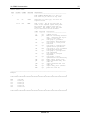
VL-PRMS Program Documentation Earthfx Incorporated 3363 Yonge Street Toronto, Ontario M4N 2M6 August 2013 Earth Science Information Systems VL-PRMS Documentation Thursday, September 26, 2013 The following report documents the operation of the VL-PRMS Extension to the VIEWLOG Modelling System If you have any questions, please call: Yours truly Dirk Kassenaar, M.Sc., P.Eng. President, Earthfx Inc. E.J. Wexler, M.S.E., M.Sc., P.Eng. Vice-President, Earthfx Inc. Tel. 416-410-4260 Email: [email protected] [email protected] [email protected] 3363 Yonge St., Toronto, Ontario, Canada M4N 2M6 T: 416.410.4260 F: 416.481.6026 www.earthfx.com 3 VL-PRMS Documentation VL-PRMS Documentation Table of Contents 1 VL-PRMS OVERVIEW ........................................................................................................ 4 1.1 VL-PRMS INTRODUCTION ............................................................................................ 4 1.2 USGS PRMS DOCUMENTATION ................................................................................... 4 1.3 OVERVIEW OF VL-PRMS CODE EXTENSIONS ................................................................ 4 1.3.1 Fully-distributed Cell Based Simulation Units .......................................................... 4 1.3.2 Additional SCS Soil Curve Rainfall-Runoff Partitioning ........................................... 5 1.3.3 Addition of Hargreaves PET Estimation Method ..................................................... 6 2 PRMS FLOW CHART ......................................................................................................... 7 3 USGS PRMS VERSIONS AND DOCUMENTATION ........................................................... 9 3.1 PRMS VERISON 1 - 1983 ............................................................................................. 9 3.1.1 1983 version - Original version 1.0 Documentation ................................................. 9 3.1.2 Version 1 Updates .................................................................................................. 9 3.2 PRMS VERSION 2.1 - MARCH 4, 1996 ..........................................................................10 3.3 PRMS VERISON 3 - NOV. 15, 2011 ..............................................................................16 4 VL-PRMS OPERATION .....................................................................................................17 4.1 4.2 4.3 5 INSTALLING VL-PRMS.................................................................................................17 STARTING VL-PRMS...................................................................................................17 LOADING AND RUNNING A VL-PRMS MASTER MTR FILE ...............................................17 OVERVIEW OF VL-PRMS INPUT FILES ...........................................................................18 5.1 5.2 5.3 5.4 MASTER MTR FILE FORMAT ........................................................................................18 CG1 FILE FORMAT CARD PARAMETERS ........................................................................19 VL-PRMS ARRAY READER DATA SETS .........................................................................19 VL-PRMS CARD PARAMETER EXTENSIONS ..................................................................20 Earthfx Inc 4 VL-PRMS Documentation 1 VL-PRMS Overview 1.1 VL-PRMS Introduction VL-PRMS is a customized version of the USGS PRMS model, adapted primarily to provide distributed cell-based recharge estimates for use in the USGS MODFLOW model simulations. The USGS Precipitation-Runoff-Modelling-System (PRMS) model Version 2.1 is the core of VLPRMS. PRMS is an open-source code for calculating all components of the hydrologic cycle on a watershed or sub-watershed scale. PRMS is a deterministic, distributed-parameter model that incorporates information on the spatial distribution of precipitation, temperature, solar radiation, soil properties, vegetation, and land use to yield outputs of estimated runoff, infiltration, ET, and groundwater recharge. The code is well documented in Leavesly et al. (1983). For the purpose of this document the term “Classic PRMS” or simply “PRMS” refers to the open source USGS code documented in Leavesly et al., 1983, while “VL-PRMS” refers to the version customized by Earthfx Inc. 1.2 USGS PRMS Documentation The original PRMS documentation is available for download from: http://pubs.er.usgs.gov/publication/wri834238 Current information on PRMS can be found at: http://wwwbrr.cr.usgs.gov/projects/SW_MoWS/PRMS.html Further information on the PRMS versions, code and input file format is included later in this document. 1.3 Overview of VL-PRMS Code Extensions The following is a summary of the changes that differentiate VL-PRMS from Classic PRMS. These changes include: 1.3.1 Fully-distributed Cell Based Simulation Units The Classic PRMS code computes water balances for a set of Hydrologic Response Units (HRUs). In Classic PRMS, HRUs are defined as areas (e.g. polygons) with uniform hydrologic properties and can represent a catchment or part of a catchment with a dominant soil type and land use. In VL-PRMS, each HRU corresponds to a rectangular cell from the underlying MODFLOW model. A direct correspondence between the HRUs and MODFLOW model cells is established and the terms can be used interchangeably. A small cell size can be selected so that values associated with land use classes, soil types, and surface water features (i.e., wetlands and lakes) can be mapped to the cells with reasonable accuracy. Earthfx Inc 5 VL-PRMS Documentation While Classic PRMS is limited to 50 HRU’s, the fully-distributed VLPRMS code supports grids with over 1 million cells. 1.3.2 Additional SCS Soil Curve Rainfall-Runoff Partitioning Classic PRMS uses a “contributing-area” method to estimate the Hortonian flow component of overland runoff from each HRU. Earthfx added the option of using a U.S. Soil Conservation Service (SCS) curve number technique. The SCS runoff curve number is based on the concept that the volume of runoff is small for small storm events but increases with the size of the rainfall event. The volume of runoff depends on the soil class and land use (SCS, 1972). The runoff volume, R, is given by: R (P I a )2 (P I a ) S Eq. 1 where (P-Ia) is the effective precipitation after initial abstraction of evaporation from canopy interception and detention storage and other similar terms. Initial abstraction is calculated explicitly in PRMS rather than assuming that it can be approximated as 0.2S as is often done. S is the potential maximum soil moisture retention and is related to the CN value by: S 1000 10 CN Eq. 2 Based on these two relationships, higher CN values yield higher runoff values. CN values are assigned based on the four soil classes (A, B, C, and D) with a well-drained clean sand being a type A soil and a muck or clay as a type D soil. For examples, see Suphunvorranop, 1985, for typical dry-season drained conditions. CN values are increased when the moisture content increases (based on antecedent rainfall and the position of the water table) so that runoff is higher under poorly-drained conditions. Land use types that generate more runoff have higher CN values such that a good quality forest (more than 50% cover) on type B soil has a CN value of 55, row crops on the same soil have a value of 78, while commercial areas typically have a CN value of around 92. The input files changes necessary to utilize this option are described in the following sections References: Suphunvorranop, 1985, Technical Publication No. 85-5, A guide to SCS runoff procedures: St. Johns River Water Management District Project Number 15/20 200 03, July 1985. Soil Conservation Service, 1972, National Engineering Handbook, Section 4 – Hydrology: U.S. Department of Agriculture –Soil Conservation Service, Washington, D.C. U.S. Department of Agriculture – Soil Conservation Service, 1985, National engineering handbook, Section 4 – Hydrology: USDA-SCS, Washington, D.C. Earthfx Inc 6 VL-PRMS Documentation 1.3.3 Addition of Hargreaves PET Estimation Method Water entering the soil in pervious areas is subject to evapotranspiration. The PRMS code has three methods for calculating potential ET: daily pan evaporation, the Hamon (1961) method, and the Jensen and Haise (1963) method. A fourth option was added to VL-PRMS to compute PET using the simpler Hargreaves model (see Hargreaves and Allen, 2003 or Wu, 1997) which requires only two climatic parameters, temperature and incident radiation. PET, in mm/day, is given by: PET = 0.0135 (T + 17.78) RS [238.8/(595.5-0.55T)] where T is the mean temperature in °C and RS is the incident solar radiation in megajoules per square meter per day (MJ/m2/day). The incident solar radiation is adjusted for each HRU based on slope and aspect, vegetation type, winter/summer cover density, and winter transmission factor (i.e., percentage of short-wave radiation through the winter vegetation canopy). Actual ET depends on the soil type and amount of water in interception storage and in the recharge zone (upper part of the active soil zone). If the amount of water in interception storage is insufficient to meet the PET demand, the deficit is extracted from the recharge zone at a rate based on soil type and the ratio of the current volume of water stored in the recharge zone to the maximum storage capacity. If the PET demand is still not met, then moisture is extracted from the lower part of the active soil zone but at a rate based on soil type and the ratio of the current volume of water stored in the lower soil zone to the maximum in storage capacity. Soil zone depth was defined by the average rooting depth of the predominant vegetation and adjusted in areas of shallow water table. Initial storage in the upper soil zone was determined based on the thickness of the recharge and soil zones multiplied by the available water. The water available for ET is equal to the difference between field capacity Excess water, defined as the soil moisture above field capacity, is allowed to percolate to the subsurface reservoir. Percolation to groundwater is assumed to have a maximum daily limit and excess infiltration is diverted to the subsurface reservoir. A daily limit was assumed based on the hydraulic conductivity of the soil at field capacity (assuming a unit gradient). Water in the subsurface reservoir can discharge to streams (as interflow) or infiltrate back to the groundwater reservoir over time. For this study, it was assumed that interflow was a small component of the overall water budget and assigned properties that allowed most of the water in the subsurface reservoir to drain back to the groundwater reservoir. The groundwater reservoir discharges to baseflow at a rate dependent on a discharge coefficient and the volume of water stored in the groundwater reservoir. In these simulations, the exponential decay coefficient was approximated by visually comparing the simulated recession with that observed in the streamflow hydrographs. References: Hamon, W.R., 1961, Estimating potential evapotranspiration: Journal of the Hydraulics Division, Proceedings of American Society Civil Engineers 87, 107-120. Hargreaves, G.A. and Allen, R.G., 2003, History and evaluation of Hargreaves evapotranspiration equation: J.ASCE, Irrigation and Drainage Eng., Volume 129, Issue 1, pp. 53-63. Jensen, M.E., and Haise, H.R., 1963, Estimating evapotranspiration from solar radiation: Journal of Irrigation and Drainage Div., ASCE 89(IR):15-41. Earthfx Inc 7 VL-PRMS Documentation Wu, I.P., 1997, A Simple evapotranspiration model for Hawaii - The Hargreaves model: College of Tropical Agriculture and Human Resources – University of Hawaii at Manoa Cooperative Extension Service CTAHR Fact Sheet Engineer’s Notebook no. 106, May 1997 2 PRMS Flow Chart A schematic flow chart (modified from Markstrom and others, 2008) describing the operation of the PRMS model is shown below. Each of the boxes in the diagram represents a "storage reservoir" in a single cell. The arrows represent the transfer of water from one reservoir to another or to an ultimate point of discharge (e.g., the atmosphere or a stream or lake). Processes related to snowpack accumulation and snowmelt were bypassed in simulations of the study area. The model tracks the volume of water in each storage reservoir as well as the flows between reservoirs each day. Each HRU can contain pervious and impervious surfaces and the water balance for each area is computed separately. For impervious areas, the model first computes capture of precipitation by canopy interception (if any) and detention storage (e.g., water captured on flat roofs or puddles in parking lots). If the impervious-zone reservoir storage capacity is exceeded, the surplus is assumed to run off. Water is removed from canopy and detention storage by evaporation. Total detention storage was assumed to be small due to the limited amount of impervious surface area under Current Conditions. For pervious areas, the model first computes canopy interception. The amount intercepted depends on the vegetation type and winter/summer vegetation cover density. Water is removed from the canopy by evaporation. Actual ET depends on the soil type and amount of water in canopy interception storage and in the recharge zone (upper part of the soil zone reservoir). If the amount of water in canopy interception storage is insufficient to meet the potential ET demand, the deficit is extracted from the lower zone but at a reduced rate based on soil type and the ratio of the storage capacity of the lower soil zone to the current volume in storage. Soil zone depth is typically defined by the average rooting depth of the predominant vegetation. References: Markstrom, S.L., Niswonger, R.G., Regan, R.S., Prudic, D.E., and Barlow, P.M., 2008, GSFLOW—Coupled ground-water and surface-water flow model based on the integration of the Precipitation-Runoff Modeling System (PRMS) and the Modular Ground-Water Flow Model (MODFLOW-2005): U.S. Geological Survey Techniques and Methods 6-D1, 240 p. Earthfx Inc 8 VL-PRMS Documentation Figure 1: PRMS Flow Chart Earthfx Inc 9 VL-PRMS Documentation 3 USGS PRMS Versions and Documentation 3.1 PRMS Verison 1 - 1983 3.1.1 1983 version - Original version 1.0 Documentation VL-PRMS is based on the original PRMS Version 1 inputs as documented in: Leavesley, G.H., Lichty, R.W., Troutman, B.M., and Saindon, L.G., 1983, Precipitation-Runoff Modeling System: User's Manual: U.S. Geological Survey Water-Resources Investigations Report 83-4238, 207 p. This document can be downloaded from the USGS Web site at: http://pubs.er.usgs.gov/publication/wri834238 VL-PRMS Note: VL-PRMS follows the primary documentation of the model input file format included on pages 77-92. 3.1.2 Version 1 Updates 1984 version - A WDM file replaces the ISAM file for the time-series data management 1991 version - Added option to output computed time series to the Watershed Data Management (WDM) file VL-PRMS note: WDM files are not used by VL-PRMS, so these changes are not applicable. Earthfx Inc 10 VL-PRMS Documentation 3.2 PRMS Version 2.1 - March 4, 1996 On March 4, 1996 the USGS released PRMS Version 2.1. This version included the following documentation changes. The version 2.1 code changes are implemented in VL-PRMS and therefore the following documentation and notes are applicable and should be considered supplemental to the Verison 1 documentation. From USGS ._. ._. . . ._ |_| |_| |\/| |_. | | \ | | ._| ._. ._. . . ._ |_| |_| |\/| |_. | | \ | | ._| ._. ._. . . ._ |_| |_| |\/| |_. | | \ | | ._| This version of PRMS is documented below. A few minor changes have been made to input card groups 1 and 4. The biggest program change is the way the time series data is accessed. Time series data is read from a WDM file. WDM files are created using IOWDM. PRMS outputs time series data to WDM files. These files are documented in the references listed below. REFERENCES : Johanson, R. C., Imhoff, J. C., and Davis, H. H., Jr., 1981, User's Manual for Hydrological Simulation Program - FORTRAN (HSPF), (Release 7.0): Environmental Research Laboratory, Athens, Ga. Leavesley, G. H., Lichty, R. W., Troutman, B. M., and Saindon, L. G., 1983, Precipitation-Runoff Modeling System : User's Manual: U.S. Geological Survey WaterResources Investigations 83-4238 Lumb, A. M., Kittle, J. L., and Flynn, K. M., 1989, Users Manual for ANNIE; a Computer Program for Interactive Hydrologic Analyses and Data Management: U.S. Geological Survey Water-Resources Investigations Report 89-4080. Flynn, K. M., Hummel, P.R., Lumb, A. M., and Kittle, J. L., 1995, User's Manual for ANNIE, Version 2, a Computer Program for Interactive Hydrologic Data Management: U.S. Geological Survey Water-Resources Investigations Report 95-4085. Earthfx Inc 11 VL-PRMS Documentation MASTER CONTROL FILE: RCRD ---1 COLUMNS ------- FORMAT ------ VARIABLE -------- DESCRIPTION --------------------------------------------FILE CONTROL RECORD--Min of 3, Max of 7 File names may be entered in any order. 1-3 A3 CODES Identifier for file type, see below for required values 11-74 A64 NAME Name of file. May be any name that is valid on the computer system being used. May include the complete path name if necessary. The length of the file name may be restricted on some machines. CODES ----*** WDM Required -------opt yes CG1 yes CG2 opt CG3 opt CG4 OPT CG5 opt CG6 opt CG7 opt OUT QDY yes opt QUN opt PLT HRU opt opt Description ---------------------------Comment record WDM file containing observed data. Simulated data may be output to this file. Card group 1, parameter and variable initialization Card group 2, storm period selection Card group 3, infiltration/ upland erosion parameters Card group 4, flow & sediment routing specifications Card group 5, precipitation form adjustment Card group 6, snowpack adjustment Card groups 7 and 8, optimizations and sensitivity Model output (print) file. output predicted daily flow (unit 20) output predicted unit flow (unit 21) output daily plots (unit42) print hru (unit 43) _______________________________________________________________________________ Example: 1 2 3 4 5 6 7 8 12345678901234567890123456789012345678901234567890123456789012345678901234567890 WDM CG1 CG2 CG3 CG4 OUT cane.wdm test03.g1 test03.g2 test03.g3 test03.g4 test03.out 1 2 3 4 5 6 7 8 12345678901234567890123456789012345678901234567890123456789012345678901234567890 Earthfx Inc 12 VL-PRMS Documentation GROUP CARD COLUMNS FORMAT VARIABLE ----- ---- ------- ------ -------1 1 DEFINITION ---------------------------------- 35 I1 IDOUT Store predicted daily mean data 0 = no storage 1 = store predicted and observed daily mean streamflow values as sequential direct access data file by water year on unit 20. 2 = same as 1, format is standard WATSTORE daily-values record. 3 = store obsv precip and disch, computed reservoir values, predicted discharge in wdm 40 I1 IUOUT Store unit values data 0 = no storage 1 = store predicted streamflow on unit 19 as sequential direct-access data file by storm. Format is standard WATSTORE unit-values record. 2 = store in wdm file 70 I1 PROB Extended Streamflow Prediction (ESP) 0 - do not run 1 - run ESP Earthfx Inc 13 VL-PRMS Documentation GROUP CARD COLUMNS FORMAT VARIABLE ----- ---- ------- ------ -------2 40 I1 ILPS 4 7 DEFINITION ---------------------------------Lapse rates 0 - use monthly lapse rates 1 - compute daily lapse rates 41-45 I5 NTS number of temperature stations 46-50 I5 NPLW number of snowpillow stations 51-55 I5 NDC number of snowcovered area depletion curves 71-80 F10.0 DAT Total basin drainage area, in acres Individual HRU values print switch 0 = no print 1 = annual summary 2 = 1 plus monthly summary 3 = 2 + daily summary 4 = write HRUs or combinations of HRUs (sub-basins) to wdm file record types SBSNS and DSNSB required. 30 I1 IPOP2 12a 11-50 8I5 DSNC(I) 13a 11-15 I5 DSNP WDM data set number for data type 9 for each rain gage data set. 16-20 I5 DSNP WDM data set number for data type 10 for each rain gage data set. WDM data set number for data types 1 thru 8. Card follows card 12. There will be a set of cards 13 and 13a for each rain gage data set. 13b 11-26 A16 STAIDT(i) Station ID for temperature station i 31-40 2I5 DSNT(j,i) ANNIE WDM data-set number for maximum(j=1) and minimum(j=2) air temperature data for station i One record 13b for each temperature sta. 13c 11-26 A16 31-35 I5 STAIDS(i) Station ID for snowpillow station i DSNS(i) ANNIE WDM data-set number for snowpillow data for station i Earthfx Inc 14 VL-PRMS Documentation GROUP CARD COLUMNS FORMAT VARIABLE ----- ---- ------- ------ -------- DEFINITION ---------------------------------One record 13b for each snowpillow station 17 17a 18 36-40 F5.2 RTB Y-intercept of temperature range (TMAX(HRU) - TSOLX(MO)) estimated solar radiation adjusted factor (PA) relation 41-45 F5.2 RTC Slope of temperature range estimated solar radiation adjustment factor (PA) relation 11-15 I5 ITSOL HRU used to computed daily temperature range (TMAX(HRU) - TSOLX(MO)) used in computation of solar radiation adjustment factor (PA) 16-75 12F5.0 TSOLX Maximum daily air temperature below which solar radiation adjustment factor (PA) equals RTB, for months Jan-Dec 11-15 F5.2 ARSA Minumum snowfall, in water equivalent, needed to reset snow albedo during snowpack accumulation stage 16-20 F5.2 ARSM Minimum snowfall, in water equivalent, needed to reset snow albedo during the snowpack melt stage 18a 11-60 5F10.0 CSEL(i) elevation of climate stations, in feet i = 1, nts 18b 11-80 14F5.2 PCR(j) override value for DRCOR for period MPCS to MPCN, j = 1, nru 18c 11-80 14F5.2 PCS(j) override value for DSCOR for period MPCS to MPCN, j = 1, NRU Earthfx Inc 15 VL-PRMS Documentation GROUP CARD COLUMNS FORMAT VARIABLE ----- ---- ------- ------ -------38 41 DEFINITION ---------------------------------- 41-45 I5 KTS index of temperature station to use 46-50 I5 KSP index of snowpillow station to use 51-55 I5 KDC index of snowcovered area depletion curve to use 56-60 I5 AIMX maximum threshold snowpack water equivalent (AI) below which the snowcovered area depletion curve is applied 61-65 F5.2 PKFAC snowpack water equivalent adjustment factor snowpillow KSP 11-75 11F5.2 SCA(j,k) Areal extent of snow cover as decimal fraction, for each 0.1 increment of the ration of areal water equivalent to the threshold water equivalent (AI) j=1,NDC, k=1,11 for 0.0 to 1.0 in increments of 0.1 one record 41 for each areal depletion curve 42 1-5 11-50 43 1-5 11-15 44 45 1-5 "DSNDV" record identifier 8I5 data set numbers for daily output. required when IDOUT = 3 data written to wdm dsn for non-zero entries (1) simulated flow (2) precipitation (3) potential evaporation (4) actual evapotranspiration (5) available soil moisture (6) ground water contribution (7) subsurface contribution (8) surface contribution DSNDV "SBSNS" record identifier I5 number of sub-basins to be written to the wdm file (max of 50) NSB "DSNSB" record identifier 11-15 I5 DSNSB(n) output data set number for this sub-basin 16-20 I5 NHRUSB(n) number of HRUs in this sub-basin (max of 50) 21-80 12I5 KHRUSB(k,n) index numbers of the HRUs contained in this sub-basin (first 12) 1-5 21-80 "DSNSB" 12I5 record identifier KHRUSB(k,n) index numbers of HRU's contained in this sub-basin (12the and greater) one record 44 (and 45 if needed) for each sub-basin ----- ---- ------- ------ -------4 2 35 I1 PRTIN ---------------------------------Print switch 0 = no Earthfx Inc 16 VL-PRMS Documentation 1 = print rainfall excess 2 = plot rainfall excess 3 = save in wdm file 4 37 I1 35 I1 37 I1 PRTOUT Print 0 = 1 = 2 = 3 = outflow switch no print outflow plot outflow save outflow in wdm file PRTIN Print 0 = 1 = 2 = 3 = inflow switch no print inflow to segment plot inflow to segment save inflow in wdm file PRTOUT Print 0 = 1 = 2 = 3 = outflow switch no print outflow from segment plot outflow from segment save outflow in wdf file 4 5 11-50 10I5 DSNQ data set numbers for segment discharge entered in same order as flow planes and channels. Required if IUOUT>=2 PRTIN or PRTOUT must be =3 4 6 11-50 10I5 DSNS data set numbers for sediment discharge entered in same order as flow planes and channels. Required if IUOUT>=2 PRTIN or PRTOUT must be =3 3.3 PRMS Verison 3 - Nov. 15, 2011 PRMS Version 3 was released on Nov. 15, 2011. Information on this release can be found at: http://wwwbrr.cr.usgs.gov/projects/SW_MoWS/PRMS.html Since this version was released after the development of VL-PRMS this documentation is not directly relevant. The USGS development of PRMS Version 3 is being completed in parallel to the development of PRMS in GSFLOW. The development of VL-PRMS at Earthfx has now been integrated into our GSFLOW products. Earthfx has implemented the code changes from VL-PRMS (Hargreaves PET, SCS runoff partitioning) into GSFLOW. Earthfx Inc 17 VL-PRMS Documentation 4 VL-PRMS Operation 4.1 Installing VL-PRMS VL-PRMS consistes of a single executable files and 2 dynamic link libraries. As an add-on to VIEWLOG, it is necessary to install VIEWLOG prior to installing VL-PRMS. Once VIELWOG is installed, the VL_PRMS file and related DLL’s can be placed in, and run from, any directory. VL-PRMS requires a VIEWLOG Green USB Key with the PM option. 4.2 Starting VL-PRMS To start PRMS, double click on the VL_PRMS.EXE file name. The program will appear as below: Figure 2: VL-PRMS Main Screen During a VL-PRMS simulation the three progress bars show the Year, Month and Day of the current simulation progress. 4.3 Loading and Running a VL-PRMS Master MTR file To start a VL-PRMS simulation, start the program and click the Run button. Clicking the Run button will direct the user to choose a ”Master” simulation data file (extension MTR). Earthfx Inc 18 VL-PRMS Documentation 5 Overview of VL-PRMS Input Files 5.1 Master MTR File Format The VL-PRMS MTR file contains a list of the related input and output files that make up the simulation. Each line of a MTR ASCII file contains a Component keyword (for example PRE) followed by a file name on the same line. For example, PRE stands for precipitation (other components are described below). A sample MTR file is as follows: PRE PAN TEM SOL CG1 OUT HRU MON ANN SUM GAG GRD STD STM STA LSRCA.pre LSRCA.pan LSRCA.tem LSRCA.rad LSRCA.G1 LSRCA.out daily_LSRCA.out Monthly_LSRCA.out Yearly_LSRCA.out Summary_LSRCA.out Gauge_LSRCA.out LSRCA100.NOD DailyFlowStatistics.out MonthlyFlowStatistics.out AnnualFlowStatistics.out The following input components are defined in the master MTR file: PRE - Precipitation File Format (year, month, day, precip at each station) PAN - Pan Evaportion File Format (year, month, day, pan evap) TEM - Temperature File Format (daily min/max temp) SOL - Solar Radiation File Format CG1 - Control File – with variables as documented in the USGS PRMS documentation NOD - VIEWLOG NOD file (as exported from the Grid Menu in VIEWLOG) defines the number of rows and columns of the gridded inputs and outputs. OUT - Defines the output listing file. This file echo’s the main inputs into an ASCII format so the user can confirm operation. (Other MTR files ending in OUT are ASCII outputs.) Earthfx Inc 19 VL-PRMS Documentation 5.2 CG1 File Format Card Parameters The CG1 File follows the ASCII “CARD GROUP” file format described in the PRMS documentation. Cards are documented as follows: 1. All card parameters as described in Leavesley et al (1983), starting on Page 77 2. PRMS 2.1 extensions to the card parameters as described in Section 3.2, above. 3. Additional VL-PRMS extensions to the card parameters are describe below: a. Array reader inputs as described in Section 5.3, below. b. Other extensions as documented Section 5.4, below. 5.3 VL-PRMS Array Reader Data sets As noted, the key benefit of VL-PRMS is the fully-distributed cell-based operation. VL-PRMS reads fully distributed parameters (i.e. cell-based values) from VIEWLOG binary grid files. The VIEWLOG grid definition is read from a NOD file as specified in the MTR file (see above). VL-PRMS Data cards 36 through 38 (Cards as described in Leavesley, 1983) are read as constants or VIEWLOG grid files. For example, the following few lines from a CG1 file show the array reader options. Keyword Constant "ARRAY" "ARRAY" "ARRAY" "ARRAY" "CONST" 0 0.0 0.0 3.2808 2.47105 Grid file Name "LSRCA_IBOUND_EDGE.GRD" "LSRCA_SlopeClass100.grd" "LSRCA_Slope100.grd" "LSRCA_TOPO.GRD" "const_DARU.GRD" The format of each line is as follows: Keyword: The keyword can be one of the following: “ARRAY” – read cell based parameter values from a binary VIEWLOG grid “CONST” – read a single constant value for this parameter Constant: The second value on the line is either the parameter value, 0, or a grid cell multiplier. For example, "CONST" 2.47105 "const_DARU.GRD" - means read a single constant value of 2.47105. ignore the array name "ARRAY" 0.0 "LSRCA_Slope100.grd" – means read data from the specified grid file Earthfx Inc 20 VL-PRMS Documentation "ARRAY" 3.2808 "LSRCA_TOPO.GRD" – means read from the grid file, and multiply each grid cell value by 3.2808 to convert the values (in this case from metres to feet) prior to processing. Note: PRMS works in imperial units, so this constant can be useful for converting metric values for input. Grid File Name: If “ARRAY” has been specified the last portion of the card contains the file name of the grid file. 5.4 VL-PRMS Card Parameter Extensions The following extensions to the Cards are used to enable the VL-PRMS options: Card Columns Format Variable Description 2 2 4 4 4 4 4 4 4 7 9 19 25a IPET=3 = Hargreaves formulation ISSR1=2 = SCS CN Number approach Changed to NOBS =No. of observation points No. of Temperature Stations No. of Snow Pillows No. of Snow depletion curves Drainage area Number of rows Number of columns No. of observation points to print =7 = Baseflow Min PET Snowcurve 11 points in tenths of SWE (refer to GSFLOW documentation) 20 25 16-20 41-45 46-50 51-55 71-80 81-85 86-90 46-50 16-65 76-80 1-80 I1 I1 I5 I5 I5 I5 I5 I5 I5 I5 I5 I5 F5.1 IPET ISSR1 NDS DAT NRow NCol NOBS IDUS Earthfx Inc