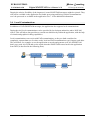
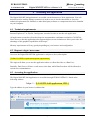
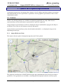
1
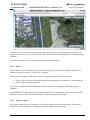
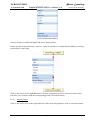
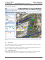
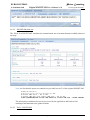
Pulsar Consulting EUROCONTROL EATM/DAP/AIM Digital SNOWTAM User’s Manual v1.0 IT Design & Solutions xSNOWTAM – UMAN Digital SNOWTAM Data User and Data Provider Interface User’s Guide & References Manual Version 1.0 UMAN-EC-Digital SNOWTAM-v1.doc Page 1/77 Printed on 12/01/10 13:57 Pulsar Consulting EUROCONTROL EATM/DAP/AIM Digital SNOWTAM User’s Manual v1.0 IT Design & Solutions DOCUMENT DISTRIBUTION LIST NAME Ludovic LAMBRECHTS Tudor IVANOV Jean-Luc LIBIOULLE Eddy POROSNICU Scott WILSON Edel GARRIHY COMPANY/SERVICE Pulsar/Consultancy Pulsar/Consultancy Pulsar/Consultancy EUROCONTROL EUROCONTROL EUROCONTROL ACR. LLS TIV JLL EPR SWI EGA ROLE Tech. Proj. Leader Project Manager Analyst / Developer Project Manager DOCUMENT CHANGE RECORD Date 2 Sept 2009 Author(s) LLS Review UMAN-EC-Digital SNOWTAM-v1.doc Description V0.1: first version Page 2/77 Sections All Printed on 12/01/10 13:57 Pulsar Consulting EUROCONTROL EATM/DAP/AIM Digital SNOWTAM User’s Manual v1.0 IT Design & Solutions CONTENTS 1 INTRODUCTION ...........................................................................................................................6 2 DISCLAIMER .................................................................................................................................7 3 DATA SETS .....................................................................................................................................8 3.1 3.2 3.3 3.4 4 ACCESSING THE APPLICATION ...........................................................................................10 4.1 4.2 4.3 4.4 5 Static data / baselines from EAD................................................................................................8 Geometric data from AMDB ......................................................................................................8 EAD SNOWTAM Messages ......................................................................................................8 Local Contaminations .................................................................................................................9 Technical requirements.............................................................................................................10 Request a login / user name ......................................................................................................10 Accessing the application .........................................................................................................10 Login.........................................................................................................................................11 SYMBOLS AND GRAPHICAL REPRESENTATIONS ..........................................................12 5.1 Features.....................................................................................................................................12 5.1.1 Airport Reference Point .....................................................................................................12 5.1.2 Runways .............................................................................................................................13 5.1.3 Taxiways.............................................................................................................................15 5.1.4 Aprons ................................................................................................................................15 5.1.5 Aircraft Stands ...................................................................................................................16 5.2 Contaminations .........................................................................................................................17 5.2.1 Contamination surface.......................................................................................................18 5.2.2 Contamination icon............................................................................................................19 5.2.2.1 5.2.2.2 5.2.2.3 6 Single and multiple layers .......................................................................................................20 Type of contaminant................................................................................................................20 Friction coefficient ..................................................................................................................20 DATA USER INTERFACE..........................................................................................................22 6.1 Introduction...............................................................................................................................22 6.2 Typical usage flow....................................................................................................................22 6.3 Main screen layout....................................................................................................................23 6.3.1 Main menu..........................................................................................................................23 6.3.2 Main working area.............................................................................................................23 6.3.3 Quick Search ......................................................................................................................23 6.4 Find airports..............................................................................................................................26 6.4.1 Search criteria....................................................................................................................26 6.4.2 Search Results ....................................................................................................................27 6.5 Airport Overview......................................................................................................................29 6.5.1 Contamination summary icons...........................................................................................30 6.6 Airport Map Page .....................................................................................................................30 6.6.1 Filters .................................................................................................................................32 6.6.2 Airport features ..................................................................................................................32 6.6.2.1 6.6.2.2 6.6.3 Airport feature .........................................................................................................................33 Other feature types ..................................................................................................................34 Airport Map........................................................................................................................35 UMAN-EC-Digital SNOWTAM-v1.doc Page 3/77 Printed on 12/01/10 13:57 Pulsar Consulting EUROCONTROL EATM/DAP/AIM 6.6.4 6.6.5 Digital SNOWTAM User’s Manual v1.0 IT Design & Solutions Visualization Options.........................................................................................................35 Viewing SNOWTAM Text...................................................................................................38 6.6.5.1 6.6.5.2 6.6.5.3 SNOWTAM Draft...................................................................................................................38 SNOWTAM plain text ............................................................................................................39 EAD – SNOWTAM ................................................................................................................39 6.7 Viewing contaminations ...........................................................................................................40 6.8 Viewing Runway Contaminations ............................................................................................41 6.9 Viewing Taxiway Contaminations ...........................................................................................41 6.10 Viewing Apron Contaminations............................................................................................42 6.11 Viewing Aircraft Stand contaminations ................................................................................42 6.12 Using the contamination dialogs ...........................................................................................43 6.13 Visualization Options ............................................................................................................43 6.14 Viewing KML .......................................................................................................................44 7 DATA PROVIDER INTERFACE ...............................................................................................46 7.1 Introduction...............................................................................................................................46 7.2 Typical usage flow....................................................................................................................46 7.3 Main Screen layout ...................................................................................................................47 7.4 Airport Map ..............................................................................................................................47 7.5 New Observation Mode ............................................................................................................48 7.6 Common fields for editing contaminations ..............................................................................48 7.6.1 Observation time ................................................................................................................49 7.6.2 Deposits..............................................................................................................................49 7.6.3 Mean depth.........................................................................................................................50 7.6.4 Friction coefficient.............................................................................................................50 7.6.5 Friction device ...................................................................................................................51 7.6.6 Further clearance ..............................................................................................................51 7.6.7 Critical snow banks............................................................................................................52 7.6.8 Obscured lights ..................................................................................................................52 7.6.9 Remark ...............................................................................................................................53 7.7 Editing/Creating Runway contaminations................................................................................55 7.7.1 Cleared surface ..................................................................................................................56 7.7.2 Further clearance ..............................................................................................................58 7.7.3 Critical snow banks and obscured lights ...........................................................................58 7.8 Editing/Creating Taxiway contaminations ...............................................................................59 7.8.1 Cleared width and side ......................................................................................................59 7.9 Editing/Creating Apron contaminations ...................................................................................60 7.9.1 Drawing custom apron surfaces ........................................................................................60 7.10 Editing/Creating Aircraft Stand contaminations ...................................................................61 7.11 Creating contaminations from existing .................................................................................62 7.12 Publishing an observation .....................................................................................................63 7.13 Cancelling an observation .....................................................................................................64 7.14 Manage rejected SNOWTAMs .............................................................................................65 7.14.1 Search criteria ................................................................................................................66 7.14.2 Editing a SNOWTAM Message.......................................................................................66 7.14.3 Statuses ...........................................................................................................................67 7.14.4 Types of errors................................................................................................................67 8 WORKING WITH GOOGLE MAPS.........................................................................................69 8.1 8.2 8.3 Moving the map ........................................................................................................................69 Zooming the map ......................................................................................................................69 Choosing a map type ................................................................................................................70 UMAN-EC-Digital SNOWTAM-v1.doc Page 4/77 Printed on 12/01/10 13:57 Pulsar Consulting EUROCONTROL EATM/DAP/AIM 9 Digital SNOWTAM User’s Manual v1.0 IT Design & Solutions ADMINISTRATION.....................................................................................................................71 9.1 Manage Operators.....................................................................................................................71 9.1.1 Search.................................................................................................................................71 9.1.2 Add .....................................................................................................................................72 9.1.3 Edit .....................................................................................................................................72 9.2 Manage Organisations ..............................................................................................................73 9.2.1 Search.................................................................................................................................73 9.2.2 Add .....................................................................................................................................73 9.2.3 Edit .....................................................................................................................................74 9.3 Manage Associations ................................................................................................................74 9.3.1 Search.................................................................................................................................75 9.4 Airport/heliport ownership .......................................................................................................75 9.4.1 Search.................................................................................................................................76 9.4.2 Take/Release ownership.....................................................................................................76 9.5 AMDB file upload ....................................................................................................................77 9.5.1 Upload a new file ...............................................................................................................77 UMAN-EC-Digital SNOWTAM-v1.doc Page 5/77 Printed on 12/01/10 13:57 Pulsar Consulting EUROCONTROL EATM/DAP/AIM Digital SNOWTAM User’s Manual v1.0 IT Design & Solutions 1 Introduction Figure 1 Home page UMAN-EC-Digital SNOWTAM-v1.doc Page 6/77 Printed on 12/01/10 13:57 Pulsar Consulting EUROCONTROL EATM/DAP/AIM Digital SNOWTAM User’s Manual v1.0 IT Design & Solutions 2 Disclaimer [TODO EPR] UMAN-EC-Digital SNOWTAM-v1.doc Page 7/77 Printed on 12/01/10 13:57 Pulsar Consulting EUROCONTROL EATM/DAP/AIM Digital SNOWTAM User’s Manual v1.0 IT Design & Solutions 3 Data sets The Digital SNOWTAM Application relies on multiple data sets. 3.1 Static data / baselines from EAD The static data about airport features is exported from EAD/SDO in AIXM 4.5 format and is converted and imported in the application in AIXM 5.1 format. The following features are available: • • • • • • • Airport/heliports Runways Runway directions Runway centreline points (thresholds) Taxiways Aprons Aircraft stands These features are regularly and automatically updated trough the EAD/ESI/ENA connection. It is not modifiable through the application. Runway geometries are computed using the two thresholds. 3.2 Geometric data from AMDB Feature geometries in AMDB format can be uploaded in the application. AMDB provides precise geometries for the following features: • • • Runways (through runway elements) Taxiways (through taxiway elements) Aprons (through apron elements) Runway geometries uploaded from AMDB will always have priority over geometries computed with threshold points. AMDB files must be sent to EUROCONTROL via email. Validity tests against the features already available in the database will be run before the file can be uploaded. EUROCONTROL will take care of the whole processing. 3.3 EAD SNOWTAM Messages The application regularly and automatically receives ICAO SNOWTAM messages through EAD/INO and converts them into valid surface contaminations as soon as they are available. The converter uses a set of rules to validate and translate SNOWTAM messages. This set of rules takes the ICAO Annex 15 – Annex II and many common variations into account. UMAN-EC-Digital SNOWTAM-v1.doc Page 8/77 Printed on 12/01/10 13:57 Pulsar Consulting EUROCONTROL EATM/DAP/AIM Digital SNOWTAM User’s Manual v1.0 IT Design & Solutions Despite the relative flexibility of the import tool, some SNOWTAM messages might be rejected. They will still be available in the application for further processing and fixing, but their contaminations won’t be processed or available in the application. See 7.14 for additional information. 3.4 Local Contaminations In addition to EAD SNOWTAM messages, the application also supports local contaminations. During the trial, local contaminations can be provided by local airport authorities and/or NOTAM offices. This will allow data providers to encode test data directly within the application, with the help of wizards and graphical editing capabilities. Local contaminations can coexist with EAD contaminations, as they are both considered as completely separate data sets. In other words, local and EAD contaminations won’t impact each other. This will allow, for example, to use the application to encode and generate an ICAO SNOWTAM draft, copy-paste it in EAD and see the result when the SNOWTAM comes back in the application from INO (as described in the following flow). Application SNOWTAM Draft IMPORT TOOL UMAN-EC-Digital SNOWTAM-v1.doc Page 9/77 EAD INO Printed on 12/01/10 13:57 Pulsar Consulting EUROCONTROL EATM/DAP/AIM Digital SNOWTAM User’s Manual v1.0 IT Design & Solutions 4 Accessing the application The Digital SNOWTAM application is accessible via the Internet as a Web Application. You will therefore need a working Internet connexion in order to use it. On the other hand, as far as the technical requirements are fulfilled, no other third party software or components need to be installed on your computer. 4.1 Technical requirements Internet Explorer 6/7 or Firefox 2 and greater is needed in order to use the web application. All application screens have been developed to accommodate a minimum resolution of 1024x768. Note, however, that the application also supports higher screen resolutions to allow you to take full advantage of the graphical capabilities of the maps. Memory requirements will vary greatly depending on your browser and configuration. 4.2 Request a login / user name Access to the Digital SNOWTAM application is subject to (free) subscription. [TODO LLS/EPR: explain subscription requirements] This login will allow you to use the application either as a Data Provider or a Data User. Basically, Data Users will have a read access to the data, while Data Providers will be allowed to encode new contaminations. 4.3 Accessing the application The Digital SNOWTAM Application is accessible through EUROCONTROL’s Portal at the following address: https://... [LLS/EPR Add application URL] Type the address in your browser’s address bar: UMAN-EC-Digital SNOWTAM-v1.doc Page 10/77 Printed on 12/01/10 13:57 Pulsar Consulting EUROCONTROL EATM/DAP/AIM Digital SNOWTAM User’s Manual v1.0 IT Design & Solutions 4.4 Login Figure 2 Login dialog [LLS/EPR/FPR: check with EC for login method in Portal] UMAN-EC-Digital SNOWTAM-v1.doc Page 11/77 Printed on 12/01/10 13:57 Pulsar Consulting EUROCONTROL EATM/DAP/AIM Digital SNOWTAM User’s Manual v1.0 IT Design & Solutions 5 Symbols and Graphical Representations Aeronautical experts have investigated the existence of civil, military and other industry conventions and standards that provide requirements or guidelines for the graphical representation of the surface contamination status. 5.1 Features Features for which geometries are available are displayed graphically on a map. Both features represented by a surface and features represented by a point are supported. Airport features represented by a surface are displayed using an outlined blue polygon (the shape is not filled). This is the case for runways, taxiways and aprons. Airport features represented by a point (aircraft stands, thresholds...) are displayed using an icon depending on their type. 5.1.1 Airport Reference Point The airport reference point is displayed using the usual ICAO symbol: The graphical visualization of SNOWTAM messages and contaminations relies heavily on features geometries. If no geometries are available, a warning shall be displayed under the reference point. UMAN-EC-Digital SNOWTAM-v1.doc Page 12/77 Printed on 12/01/10 13:57 Pulsar Consulting EUROCONTROL EATM/DAP/AIM 5.1.2 Digital SNOWTAM User’s Manual v1.0 IT Design & Solutions Runways Runways are displayed as outlined blue polygons. In order to be compliant with ICAO Annex 15 – Appendix 2 and OPADD document for the encoding of contaminations and SNOWTAM messages, runways are divided into thirds. The thirds are numbered from the lower runway designator / threshold: UMAN-EC-Digital SNOWTAM-v1.doc Page 13/77 Printed on 12/01/10 13:57 Pulsar Consulting EUROCONTROL EATM/DAP/AIM Digital SNOWTAM User’s Manual v1.0 IT Design & Solutions When no AMDB data is available, runway geometries are computed by using the two threshold point’s coordinates and the published runway width. So, at the very least, runway thresholds should be available in EAD to be able to visualize runways. It may happen that, for some airports, the runway geometry doesn’t match the picture of the runway on the map: This may be due to: • • • • • An incorrect runway width in EAD No runway width (in which case a default value of 45 meters is used) Wrong threshold coordinates or displaced thresholds [TODO check with EPR] No threshold and no AMDB data available (in which case the application can’t display the runway) Maps of type ‘Terrain’ and ‘Map’ may be less precise than the satellite map (and thus the displayed picture may appear shifted) If needed, the information can be corrected or completed in EAD and sent as an update, which the application will take into account automatically. Here’s a sample representation of a runway, displaying: • • • • The runway itself (the blue box) runway thirds runway thresholds runway label and threshold labels UMAN-EC-Digital SNOWTAM-v1.doc Page 14/77 Printed on 12/01/10 13:57 Pulsar Consulting EUROCONTROL EATM/DAP/AIM 5.1.3 Digital SNOWTAM User’s Manual v1.0 IT Design & Solutions Taxiways Taxiways are displayed as outlined blue polygons. Here’s a sample view of several taxiways on an airport: Taxiway geometries are only available through AMDB data. If such data is available, send the AMDB file for the corresponding airport to EUROCONTROL in order to take advantage of this functionality. 5.1.4 Aprons Aprons are displayed as an outlined blue polygon. UMAN-EC-Digital SNOWTAM-v1.doc Page 15/77 Printed on 12/01/10 13:57 Pulsar Consulting EUROCONTROL EATM/DAP/AIM Digital SNOWTAM User’s Manual v1.0 IT Design & Solutions Apron geometries are only available through AMDB data. Send an AMDB file for the corresponding airport to EUROCONTROL in order to take advantage of this functionality (see chapter “3.2 Geometric data from AMDB” on page 8). 5.1.5 Aircraft Stands Aircraft stands are displayed as blue dot shaped icons. Here’s a sample representation of some aircraft stands. UMAN-EC-Digital SNOWTAM-v1.doc Page 16/77 Printed on 12/01/10 13:57 Pulsar Consulting EUROCONTROL EATM/DAP/AIM Digital SNOWTAM User’s Manual v1.0 IT Design & Solutions In order to avoid overloading the map, aircraft stands labels are not displayed as other feature labels. The labels with the stand designator are displayed when the mouse moves over a stand. Aircraft stands are made available from EAD data. 5.2 Contaminations Feature contaminations are displayed in two ways: 1. The surface of the feature is filled with a color corresponding to the contaminant of the upper layer 2. A color-coded and triangle shaped icon is placed on the feature, showing the most important information: the friction coefficient and the type of contaminant of the upper layer UMAN-EC-Digital SNOWTAM-v1.doc Page 17/77 Printed on 12/01/10 13:57 Pulsar Consulting EUROCONTROL EATM/DAP/AIM 5.2.1 Digital SNOWTAM User’s Manual v1.0 IT Design & Solutions Contamination surface When features are contaminated, their surface is filled using a semi-transparent color which corresponds to the type of the upper most layer of contaminant: UMAN-EC-Digital SNOWTAM-v1.doc Page 18/77 Printed on 12/01/10 13:57 Pulsar Consulting EUROCONTROL EATM/DAP/AIM Digital SNOWTAM User’s Manual v1.0 IT Design & Solutions While not displayed graphically, the other contaminants are still available in the view/edit dialogs in the application; As an example, consider item F) of the following SNOWTAM message: A)LSZH B)09280852 C)10 F)27/5/9 The 1st third of the runway is contaminated by water over ice (value 27), only the water layer is visible for this third 5.2.2 Contamination icon The contamination icon carries the most important information about the contamination of the corresponding feature: • Single or multiple layers • Type of contaminant of the top layer • Friction coefficient (textual number and color code) It is meant to be a visual quick summary of the contamination. UMAN-EC-Digital SNOWTAM-v1.doc Page 19/77 Printed on 12/01/10 13:57 Pulsar Consulting EUROCONTROL EATM/DAP/AIM Digital SNOWTAM User’s Manual v1.0 IT Design & Solutions 5.2.2.1 Single and multiple layers A single triangle is used when there is a single layer of contamination (one single contaminant): Figure 3 Single layer contamination icon When the contamination consists in multiple layers of contaminants, the icon is displayed as a double triangle. Figure 4 Multiple layer contamination icon Important notice: the number of triangles does NOT depict the number of layers. 5.2.2.2 Type of contaminant The icon contains the denomination of the upper most contaminant (the top layer). 5.2.2.3 Friction coefficient The friction coefficient (aka braking action) is displayed using the following two conventions: A number (1-5 or 9) A background color (red, yellow, green or gray) The number always corresponds to the estimated friction coefficient; even if the actual value contained in the SNOWTAM or contamination is measured (the real coefficient is still available in the application). The application uses the same conventions as the ICAO SNOWTAM form (except for the color): Measured Coefficient UMAN-EC-Digital SNOWTAM-v1.doc Estimated friction Page 20/77 Color Printed on 12/01/10 13:57 Pulsar Consulting EUROCONTROL Digital SNOWTAM User’s Manual v1.0 EATM/DAP/AIM 0.40 and above 0.39 – 0.36 0.35 – 0.30 0.29 – 0.26 0.25 and below 9 – unreliable GOOD MEDIUM/GOOD MEDIUM MEDIUM/POOR POOR UNRELIABLE 5 4 3 2 1 9 IT Design & Solutions Green Yellow Yellow Yellow Red Red Grey color is used when no coefficient is available. However, this should not happen. As an example, consider the following SNOWTAM message: A) ENAT B) 10290728 C) 11 F) 67/1/1 G) 4// H) 3/5/5 It will be displayed using the following icons: UMAN-EC-Digital SNOWTAM-v1.doc Page 21/77 Printed on 12/01/10 13:57 Pulsar Consulting EUROCONTROL Digital SNOWTAM User’s Manual v1.0 EATM/DAP/AIM IT Design & Solutions 6 Data User Interface 6.1 Introduction As Data User, you have access to the Data User Interface, which provides read access to textual and graphical representations of features and contaminations for all airports 1 , world-wide. After login, no action is required on your side. The application will automatically direct you to the appropriate page. Data Providers also have access to the Data User Interface. In fact, to allow maximum flexibility, the Data User and Data Provider Interfaces have been built together into a single application, with a single point of access. Most screens are common to both Interfaces. Depending on your access rights, you will have access to more or less functionalities. It is certainly a good idea to read the following chapters about the Data User Interface even if you have Data Provider access! 6.2 Typical usage flow The typical usage flow of the Data User Interface is as follows: Login 1. 2. 3. Enter your login name and password Find airports Airport Overview Find Airport Page Quick Search Feature An overview of the current SNOWTAM situation, World-wide! View airport contaminations View the airport, its associated features and contaminations on a map 1 More than 15000 airports are available through EAD export UMAN-EC-Digital SNOWTAM-v1.doc Page 22/77 Printed on 12/01/10 13:57 Pulsar Consulting EUROCONTROL EATM/DAP/AIM Digital SNOWTAM User’s Manual v1.0 IT Design & Solutions 6.3 Main screen layout Application screens are divided in multiple sections: 6.3.1 Main menu The Main menu is the heart of the navigation into the application. This is where you can choose the actions you want to perform within the application. Each menu item can be clicked. This will load the requested page into the Main working area. 6.3.2 Main working area The main working area is where the application pages are loaded. 6.3.3 Quick Search The Quick Search feature is a convenient way to find airports very easily and quickly, based on ICAO/IATA designators and airport name. The selection of an airport will open the corresponding Airport Map page, which is used to display the contaminations. Type any combination of characters to trigger the search (a minimum of 3 characters is required for the search to take place). The search results will contain all airports whose designators or name match the specified criterion: UMAN-EC-Digital SNOWTAM-v1.doc Page 23/77 Printed on 12/01/10 13:57 Pulsar Consulting EUROCONTROL EATM/DAP/AIM Digital SNOWTAM User’s Manual v1.0 IT Design & Solutions This search field also support the ‘*’ or ‘%’ wildcard characters (replacing any group of letters). Note that the Quick Search feature doesn’t support temporal queries and that the Airport Map Page will always be opened with the current date and time. Once the search results are displayed, you can navigate through the airport list with the keyboard (with up/down arrows) and press the RETURN key to select the airport. You can also use the mouse and click on the desired airport. If the search results contain too many airports, they will be divided in multiples “pages” that can be browsed with the help of the paging toolbar at the bottom of the list: UMAN-EC-Digital SNOWTAM-v1.doc Page 24/77 Printed on 12/01/10 13:57 Pulsar Consulting EUROCONTROL Digital SNOWTAM User’s Manual v1.0 EATM/DAP/AIM IT Design & Solutions Example search results: Criterion LS Results No results (minimum 3 characters needed) LS* All airports where designator ICAO or designator IATA starts with ‘LS’ (no airport name starts with ‘LS’ LSZ All airports where designator ICAO or designator IATA contains ‘LSZ’ (no airport name contains with ‘LSZ’) LSZH LSZH/Zurich (Zurich Airport, Switzerland) BRUSSEL All airports whose name contains ‘BRUSSEL’ (as ICAO and IATA designators have a max length of 4 characters, they will never match any criterion with more than 4 characters so, in that case, only the airport name is taken into account. ‘BRUSSEL’ will match the following airports: • CPD4 / BRUSSELS (ARMSTRONG FIELD) • EBBR / BRUSSELS/BRUSSELS-NATIONAL UMAN-EC-Digital SNOWTAM-v1.doc Page 25/77 Printed on 12/01/10 13:57 Pulsar Consulting EUROCONTROL EATM/DAP/AIM Digital SNOWTAM User’s Manual v1.0 IT Design & Solutions • EBUB / BRUSSELS/ULB • EBUC / BRUSSELS/UCL 6.4 Find airports The “Find airports” screen, always accessible through the “Find Airports” menu item, allows you to find specific airports and show if a SNOWTAM is active for each retrieved airport at ‘query time’. Figure 5 Find airport page for data users 6.4.1 Search criteria Search for airports is allowed by: • • • ICAO designator (1) Airport name (2) IATA designator (3) All those search criteria accept the ‘*’ and ‘%’ wildcard characters (which stand for ‘any group of character) both at the beginning and/or at the end of the criterion. Both characters have the same meaning and can be used indifferently, depending on your preference. Examples: • ‘EB*’ in ICAO field will find all airports whose designator ICAO starts with ‘EB’ (i.e. EBBR, EBOS...) UMAN-EC-Digital SNOWTAM-v1.doc Page 26/77 Printed on 12/01/10 13:57 Pulsar Consulting EUROCONTROL EATM/DAP/AIM • Digital SNOWTAM User’s Manual v1.0 IT Design & Solutions ‘*STOCK*’ in Name field will retrieve all airports whose name contains the word ‘STOCK’ (i.e. STOCKHOLM ARLANDA, STOCKTON METROPOLITAN, ...) The “Query Time (UTC)” field (4) allows for historical searches. This field is used by the application to retrieve SNOWTAM information. It will also be used when displaying the Airport Map Page of the selected airport. By default, the field contains the current UTC date/time. Clicking on the “Now” button (5) will reset the query time by retrieving the current UTC time from the server. Click on the “Search” button or press the “RETURN” key in any field to do the search. While the server processes the request, the result grid becomes disabled and a loading mask is displayed: When the results are available, the grid becomes enabled again and the first row is selected / highlighted. 6.4.2 Search Results [TODO: produce this screenshot with final version, in DUI, add markers] UMAN-EC-Digital SNOWTAM-v1.doc Page 27/77 Printed on 12/01/10 13:57 Pulsar Consulting EUROCONTROL EATM/DAP/AIM Digital SNOWTAM User’s Manual v1.0 IT Design & Solutions The result table contains the list of airports/heliports matching the search criteria. A row displayed in bold with a snowflake in the first column means that the corresponding airport/heliport has a valid/active SNOWTAM at the Query Time. A single-click on the plane icon in the last column or a double-click on a row will open the Airport Map Page for the corresponding airport. The result grid also supports keyboard navigation so it is also possible to use the up/down arrow keys to navigate through the results and press the RETRUN key to open the Airport Map Page of the highlighted airport/heliport. TIP: if you know the airport designator, type it in the designator field, press the ‘return’ key, wait for the grid to load, press the ‘return’ key again. This will load the Airport Map Page for the corresponding airport, without using the mouse and without complicated handling. I.e.: ‘EBBR’, [Return], [Return]. If the query returns too many results, the list of airports/heliports will be paginated (split in multiple pages). Navigating through multiple result pages is possible with the help of the navigation toolbar at the bottom of the grid: UMAN-EC-Digital SNOWTAM-v1.doc Page 28/77 Printed on 12/01/10 13:57 Pulsar Consulting EUROCONTROL EATM/DAP/AIM Digital SNOWTAM User’s Manual v1.0 IT Design & Solutions 6.5 Airport Overview The “Airport Overview” screen shows a summary of the contamination status of a region for airports having at least one runway. The view is initially centred on Europe. The displayed airports are refreshed every time the map is moved or zoomed. Note: some airports might seem to be missing in the bottom of the map, especially at low zoom levels. This is due to the fact that our geographic queries take the earth curvature into account, but Google Maps doesn’t (coordinates are projected). UMAN-EC-Digital SNOWTAM-v1.doc Page 29/77 Printed on 12/01/10 13:57 Pulsar Consulting EUROCONTROL Digital SNOWTAM User’s Manual v1.0 EATM/DAP/AIM 6.5.1 IT Design & Solutions Contamination summary icons A contamination summary icon is associated to every airport. Click on the icon to open the airport in the Airport Map Page. The table below illustrates the possible icon colours and their respective meaning: Icon Meaning No active contamination on the airport There exists contamination information but the deposits of all runways are set to NONE and the friction coefficient is "GOOD" or between 0.40-0.99 or unspecified There exists contamination information and the friction coefficient is "POOR", below 0.25 or "UNRELIABLE" for at least one of the runways All other situations including airport/heliport closed There exists a SNOWTAM but it has errors Possible actions on the map: • • • • • Change the map type using the map type selector. Zoom in, zoom out. Drag the map (move it using the mouse to show a different zone). “Hover” the cursor over a bullet to see the corresponding airport designator. Click on a bullet to open the airport page of the corresponding airport/heliport. Performance issue: There are more than 15000 airports/heliports in the database. The number of bullets to calculate and display in this screen depends on the size of the geographical area to display, hence to the zoom level. In addition, in some regions of the world, the high density of airports/heliports at some high altitude (zoom level) might make the map look cluttered. The bullets can be so close of each others that it’s almost impossible to click on the right one. For these reasons, only airports/heliports with more than one runway are selected. 6.6 Airport Map Page The Airport Map is the main screen of the application. It offers both textual and graphical view of airport features and contaminations. View Create/Edit Features Yes - Contaminations Yes - UMAN-EC-Digital SNOWTAM-v1.doc Page 30/77 Printed on 12/01/10 13:57 Pulsar Consulting EUROCONTROL EATM/DAP/AIM Digital SNOWTAM User’s Manual v1.0 IT Design & Solutions The screen is divided into four areas: • • • • Filters Airport features Airport map Visualisation options The left and right columns (the “filters/airport features” and “visualization options” areas can be almost completely hidden to give more space to the map. This may come in handy with smaller screen resolutions. Once collapsed, the panels become only a narrow vertical bar: UMAN-EC-Digital SNOWTAM-v1.doc Page 31/77 Printed on 12/01/10 13:57 Pulsar Consulting EUROCONTROL EATM/DAP/AIM Digital SNOWTAM User’s Manual v1.0 IT Design & Solutions Click on the bar itself to reopen the panels temporarily (the panel will collapse back as soon as the mouse cursor moves over the map) or click on the little arrows on top of the bars to expand the panels normally. Note that each panel can be collapsed and/or expanded individually. 6.6.1 Filters Filters allow you to reload the map with a different query time or a different dataset. Datasets are further explained in section “3. Data sets” on page 8. The first time the page is loaded, the dataset is selected using the following criterion: • ‘Local’ will be selected if the airport has local contaminations (encoded by a local authority) • ‘EAD’ will be selected otherwise If you select a different dataset, this dataset will be used once you apply the filter and the page is reloaded. By default the UTC Date/time uses the value selected in the “Find airports” page or the current UTC date/time if you used the Quick Search feature or the Airport Overview page. 6.6.2 Airport features The airport features area is a textual list of available features for the selected airport. Features are displayed by their designator / identification and are grouped by feature type: UMAN-EC-Digital SNOWTAM-v1.doc Page 32/77 Printed on 12/01/10 13:57 Pulsar Consulting EUROCONTROL EATM/DAP/AIM Digital SNOWTAM User’s Manual v1.0 IT Design & Solutions Only the features available through EAD can be displayed here. Feature groups (Airport, Runways, Aprons...) may be expanded or collapsed individually by clicking on the arrows on the right. Click on the arrows on the right-hand side of feature designators to open a contextual menu which will allow you to interact with the corresponding feature (described below). 6.6.2.1 Airport feature Click on the arrows icon on the right-hand side of the airport designator to open its contextual menu. UMAN-EC-Digital SNOWTAM-v1.doc Page 33/77 Printed on 12/01/10 13:57 Pulsar Consulting EUROCONTROL EATM/DAP/AIM Digital SNOWTAM User’s Manual v1.0 IT Design & Solutions From the airport contextual menu you can: • Centre the map on the airport reference point • Show the current SNOWTAM text (if available) • View the currently active baseline details about the airport (this will open in a new popup) Important notice: Currently, global information/contaminations about the whole airport are only available through the “View SNOWTAM” feature. This includes the content of item T (plain text remark). See chapter “6.6.5 Viewing SNOWTAM Text” page 38 for more information. 6.6.2.2 Other feature types If the feature has a geometry that can be displayed, clicking on the designator will centre the map on the corresponding feature. Click on the arrows icon on the right-hand side of the feature designator to open its contextual menu. From the airport contextual menu you can: • Show the current contamination (if any) • View the currently active baseline details about the feature (this will open in a new popup) UMAN-EC-Digital SNOWTAM-v1.doc Page 34/77 Printed on 12/01/10 13:57 Pulsar Consulting EUROCONTROL EATM/DAP/AIM Digital SNOWTAM User’s Manual v1.0 IT Design & Solutions When contaminations affect a specific feature, the corresponding contamination icon is also visible nearby the feature designator: 6.6.3 Airport Map The Airport Map is the central piece of the application. It allows graphical visualization of airport features and contaminations (when available). For more details about how features and contaminations are displayed on the map, please refer to chapter 5 “Symbols and Graphical Representations” on page 12. 6.6.4 Visualization Options For some airports with a lot of feature geometries, the map can quickly become overloaded. The “Visualisation Options” panel gives you full control over what is visible on the map. UMAN-EC-Digital SNOWTAM-v1.doc Page 35/77 Printed on 12/01/10 13:57 Pulsar Consulting EUROCONTROL EATM/DAP/AIM Digital SNOWTAM User’s Manual v1.0 IT Design & Solutions By checking/unchecking the boxes, you can show/hide the corresponding feature geometries and/or labels. The box nearby the feature type (Runways....) allow you to completely show/hide specific features in one click. Figure 6 Satellite view of airport map UMAN-EC-Digital SNOWTAM-v1.doc Page 36/77 Printed on 12/01/10 13:57 Pulsar Consulting EUROCONTROL EATM/DAP/AIM Digital SNOWTAM User’s Manual v1.0 IT Design & Solutions Figure 7 Map view of airport map Figure 8 Hybrid view of airport map UMAN-EC-Digital SNOWTAM-v1.doc Page 37/77 Printed on 12/01/10 13:57 Pulsar Consulting EUROCONTROL EATM/DAP/AIM Digital SNOWTAM User’s Manual v1.0 IT Design & Solutions Figure 9 Terrain view of airport map 6.6.5 Viewing SNOWTAM Text When a SNOWTAM message or contaminations are available for the selected airport, the “SNOWTAM Text” button in the bottom-right corner of the map will be enabled. Click on this button to open a dialog showing • Contaminations as SNOWTAM draft (as generated by the application) • Contaminations as plain text • The EAD SNOWTAM (as received from EAD) if applicable Currently, airport wide contaminations can only be viewed in the “item T)” and “global remarks” fields. This is also the case for information contained in an original SNOWTAM message that couldn’t be attached to a particular feature. This fact is emphasized in the screenshots below. 6.6.5.1 SNOWTAM Draft The SNOWTAM Draft is generated by the application based on the contaminations provided by Data Providers and on the parsing and translation of official ICAO SNOWTAM messages coming from EAD. The SNOWTAM Draft is ICAO compliant. UMAN-EC-Digital SNOWTAM-v1.doc Page 38/77 Printed on 12/01/10 13:57 Pulsar Consulting EUROCONTROL EATM/DAP/AIM Digital SNOWTAM User’s Manual v1.0 IT Design & Solutions 6.6.5.2 SNOWTAM plain text The “Plain Text SNOWTAM” translates the contamination into a formatted human readable plain text message. Note: the fact that the apron was sanded was provided in item T) of the original SNOWTAM: A)BGSS B)10291130 C)14 F)37/37/37 G)2/2/2 H)50/57/57 TAP N)050PCT 2MM TYP37 - BA 65 TAP R)100PCT 3MM TYP7 PCT 100PCT 1MM TYP3 - BA 40 TAP T)RWY CONTAMINATION 025PCT 1MM RIME PCT 010PCT 1MM ICE - APRON SANDED) The information could therefore not be processed by the application and has been left unchanged and attached to the global remarks. 6.6.5.3 EAD – SNOWTAM UMAN-EC-Digital SNOWTAM-v1.doc Page 39/77 Printed on 12/01/10 13:57 Pulsar Consulting EUROCONTROL EATM/DAP/AIM Digital SNOWTAM User’s Manual v1.0 IT Design & Solutions The “EAD – SNOWTAM” tab contains the original SNOWTAM message as it was received from EAD, without any interpretation or correction. If the SNOWTAM was created within the application (so didn’t come from EAD), the tab will only contain the ‘NIL’ value. 6.7 Viewing contaminations When contaminations are available, they are accessible through the textual feature list on the right, by clicking on the ‘View contamination’ in the corresponding menu: This will open a new dialog containing detailed information about the conditions on the selected feature. The contamination information is new read-only (it cannot be edited). UMAN-EC-Digital SNOWTAM-v1.doc Page 40/77 Printed on 12/01/10 13:57 Pulsar Consulting EUROCONTROL EATM/DAP/AIM Digital SNOWTAM User’s Manual v1.0 IT Design & Solutions The dialogs differ depending on the specificities of each feature type and are described in the following chapters. Remember: Currently, global information about the whole airport is only available through the “SNOWTAM Text” feature. This includes the content item T (plain text remark). 6.8 Viewing Runway Contaminations Runway contaminations are always displayed by thirds. 6.9 Viewing Taxiway Contaminations Detailed information about taxiway contaminations is always accessible through the feature list on the right, by clicking on the ‘View contamination’ in the corresponding menu: UMAN-EC-Digital SNOWTAM-v1.doc Page 41/77 Printed on 12/01/10 13:57 Pulsar Consulting EUROCONTROL EATM/DAP/AIM Digital SNOWTAM User’s Manual v1.0 IT Design & Solutions 6.10 Viewing Apron Contaminations Detailed information about apron contaminations is always accessible through the feature list on the right, by clicking on the ‘View contamination’ in the corresponding menu: 6.11 Viewing Aircraft Stand contaminations Detailed information about aircraft stand contaminations is always accessible through the feature list on the right, by clicking on the ‘View contamination’ in the corresponding menu: UMAN-EC-Digital SNOWTAM-v1.doc Page 42/77 Printed on 12/01/10 13:57 Pulsar Consulting EUROCONTROL EATM/DAP/AIM Digital SNOWTAM User’s Manual v1.0 IT Design & Solutions 6.12 Using the contamination dialogs Tip: The dialogs can be closed by clicking on the ‘Close’ button or on the “X” symbol in the upper right corner. The “_” symbol nearby can be used to show/hide the dialog temporarily (this can be used to see the map, while keeping the dialog at hand). A double-click on the dialog title has the same effect. 6.13 Visualization Options The “Visualization Options” panel is located on the right of the Airport Map view. The panel allows for fine tuning which visual information is overlaid on the airport map. This is especially useful when the airport map is cluttered as shown below. UMAN-EC-Digital SNOWTAM-v1.doc Page 43/77 Printed on 12/01/10 13:57 Pulsar Consulting EUROCONTROL EATM/DAP/AIM Digital SNOWTAM User’s Manual v1.0 IT Design & Solutions Figure 10 Visualization options panel Each information category can be selected/deselected individually. In addition, all the categories of a feature can be selected/deselected at once using the feature check box. Check a category (e.g. label in runway section) to show it, uncheck the category to hide it. Check a feature (e.g. runway) to show all the corresponding categories, uncheck the feature to hide them. Click on the icon in upper right corner of the panel to show/hide it. Hiding the panel allows for saving a significant area of the screen 6.14 Viewing KML UMAN-EC-Digital SNOWTAM-v1.doc Page 44/77 Printed on 12/01/10 13:57 Pulsar Consulting EUROCONTROL EATM/DAP/AIM Digital SNOWTAM User’s Manual v1.0 IT Design & Solutions When a SNOWTAM is available for the selected airport, the application allows downloading a KML export of the airport features and contaminations. This KML file can be opened in Google Earth to display a three dimensional view of the airport. Note: once opened in another application, the data contained in the file is totally detached. Editions made to the data in third party applications won’t be imported in the Digital SNOWTAM application in any way. UMAN-EC-Digital SNOWTAM-v1.doc Page 45/77 Printed on 12/01/10 13:57 Pulsar Consulting EUROCONTROL Digital SNOWTAM User’s Manual v1.0 EATM/DAP/AIM IT Design & Solutions 7 Data Provider Interface 7.1 Introduction As Data Provider, you have access to the Data Provider Interface, which provides read access to textual and graphical representations of features and contaminations for all airports, world-wide. You will also be able to create and edit contaminations all airports for which your organization has ownership 2 . After login, no action is required on your side. The application will automatically direct you to the appropriate section. Data Providers also have access to the Data User Interface. In fact, to allow maximum flexibility, the Data User and Date Provider Interfaces have been built together into a single application, with a single point of access. Most screens are common to both Interfaces. Depending on your access rights, you will have access to more or less functionalities. It is certainly a good idea to read the chapter about the Data User Interface even if you have Data Provider access (see “6 - Data User Interface” page 22)! 7.2 Typical usage flow The typical usage flow of the Data Provider Interface is as follows: Login 1. 2. Enter your login name and password Find airports Airport Overview Find Airport Page Quick Search Feature An overview of the current SNOWTAM situation, World-wide! New Observation 3. Create new surface contaminations for all affected airport/heliport features. Your observation remains only visible by you until it is published. 2 Ownership is a right to an organization on an airport which allows creating and editing contaminations UMAN-EC-Digital SNOWTAM-v1.doc Page 46/77 Printed on 12/01/10 13:57 Pulsar Consulting EUROCONTROL Digital SNOWTAM User’s Manual v1.0 EATM/DAP/AIM IT Design & Solutions Publish The application will activate the contaminations and generate the corresponding ICAO SNOWTAM Draft. 4. Your observation becomes publicly available. 5. View airport contaminations View the airport, its associated features and contaminations on a map 7.3 Main Screen layout The screen layout is almost identical to the Data User Interface; please refer to the corresponding chapters. However, as a Data Provider, you also have access to a screen allowing the management of rejected SNOWTAM Messages (non standard messages received from EAD that the application was unable to translate automatically). 7.4 Airport Map The Airport Map is the main screen of the application. It offers both textual and graphical viewing and editing of airport features and contaminations: View Create/Edit Features Yes - Contaminations Yes Yes UMAN-EC-Digital SNOWTAM-v1.doc Page 47/77 Printed on 12/01/10 13:57 Pulsar Consulting EUROCONTROL EATM/DAP/AIM Digital SNOWTAM User’s Manual v1.0 IT Design & Solutions Its layout is globally the same as in the Data User Interface, except for some extra capabilities: • • • • create a New Observation create and edit surface contaminations close/open airports and runways manage rejected SNOWTAMS 7.5 New Observation Mode By default, the Airport Map is displayed in view mode. To encode new contaminations (and as such create a SNOWTAM Draft), click on the “New Observation” button on the upper-right part of the map. Note: you must be a member of an organisation which has ownership over the current airport to be able to add new observations. The map will reload to enable creating new contaminations on airport features. To highlight the fact that it is in Observation Mode, the map header will change color and become orange. Also, the ‘New Observation” button will be replaced by “Publish” and “Cancel” buttons. 7.6 Common fields for editing contaminations While contaminations dialogs differ between feature types, they have a few fields in common. This chapter explains those common fields and how to work with them. UMAN-EC-Digital SNOWTAM-v1.doc Page 48/77 Printed on 12/01/10 13:57 Pulsar Consulting EUROCONTROL EATM/DAP/AIM 7.6.1 Digital SNOWTAM User’s Manual v1.0 IT Design & Solutions Observation time This field allows entering a specific UTC time for each observation (item B). The query time used in the filters section is used by default. The time must be in HH:MM format (24h); otherwise a validation error will be raised: Note that changing the value of this field will have no effect on the ICAO SNOWTAM Draft, where only the global observation time (defined in filter) will be used. 7.6.2 Deposits This field allows editing one or more contaminant layers (item F). To add a layer, click on the icon. To remove a specific layer, click on the UMAN-EC-Digital SNOWTAM-v1.doc Page 49/77 icon. Printed on 12/01/10 13:57 Pulsar Consulting EUROCONTROL EATM/DAP/AIM Digital SNOWTAM User’s Manual v1.0 IT Design & Solutions In concordance with ICAO Annex 15, deposits must be specified from top to bottom (upper layer first). You must always specify a contaminant for an upper layer before adding a new layer. In other words, you cannot add a new layer if the current bottom layer is set to "none" 7.6.3 Mean depth Mean depth allows specifying the mean depth of all contaminants (item G). It applies to all the layers at once (not layer by layer). A unit of measurement is mandatory if a measure is provided. The selection may be made with the mouse, keyboard up and down arrow keys or by typing the corresponding value directly (in which case auto-completion is enabled). Check the “xx” check box if the depth exists but can’t be measured. 7.6.4 Friction coefficient The friction coefficient supports all ICAO SNOWTAM formats (item H). Supported formats are: • 0.00 0.99 (measured) UMAN-EC-Digital SNOWTAM-v1.doc Page 50/77 Printed on 12/01/10 13:57 Pulsar Consulting EUROCONTROL EATM/DAP/AIM Digital SNOWTAM User’s Manual v1.0 IT Design & Solutions • 1 5 (single digit = estimated) • 9: unreliable The application will analyze the value and provide information about it next to the field (“measured”, “est. good”...). Invalid values will be outlined in red, mouse the mouse over the field to display a tooltip explaining the error. 7.6.5 Friction device Select a friction measurement device (item H) if the coefficient was measured. The selection may be made with the mouse or keyboard up and down arrow keys. Limited autocompletion is enabled: type the first letter of an abbreviation to automatically select the first matching item in the list. 7.6.6 Further clearance The application allows you to specify if and when further clearance of the feature is planned (items L and M for runways). UMAN-EC-Digital SNOWTAM-v1.doc Page 51/77 Printed on 12/01/10 13:57 Pulsar Consulting EUROCONTROL EATM/DAP/AIM Digital SNOWTAM User’s Manual v1.0 IT Design & Solutions Total clearance (item L) and further clearance time (item M) are supported for all feature types, unlike standard ICAO SNOWTAM messages, where it is only supported for runways. 7.6.7 Critical snow banks Check the “present” check box if snow banks affect the corresponding feature (item J) to enable the distance, depth and side fields (they are disabled by default when creating a new contamination). Units of measurement are mandatory if a measure is provided. The selection may be made with the mouse, keyboard up and down arrow keys or by typing the corresponding value directly (in which case auto-completion is enabled). 7.6.8 Obscured lights If lights are obscured, check the checkbox. Next, select “Left”, “Right” or “BOTH” in the select box if applicable (“BOTH” is equivalent to “LR” from the SNOWTAM form). UMAN-EC-Digital SNOWTAM-v1.doc Page 52/77 Printed on 12/01/10 13:57 Pulsar Consulting EUROCONTROL EATM/DAP/AIM Digital SNOWTAM User’s Manual v1.0 IT Design & Solutions 7.6.9 Remark Remark is a free text field which supports any text entry. Its content will be appended in to the item T of the ICAO SNOWTAM Draft. It may be used to provide additional information about a feature, such as “de-icing in progress”, “runway sanded”... Its position and size may vary depending on the dialog. In a usual ICAO SNOWTAM message, this information would have been provided in the global item T). However, this application allows you to specify those remarks for the corresponding feature. This will ensure better conciseness and flexibility. Note that as this now information is provided “in context” (that is, for the corresponding feature), there is no need to specify the designator and feature type anymore. See the example below. When the ICAO text version of those contaminations will be generated, all those remarks will be aggregated in the “item T)” field. For example, we have typed remarks for both runways of airport EDDH: UMAN-EC-Digital SNOWTAM-v1.doc Page 53/77 Printed on 12/01/10 13:57 Pulsar Consulting EUROCONTROL EATM/DAP/AIM Digital SNOWTAM User’s Manual v1.0 IT Design & Solutions This will result in the following text formats: UMAN-EC-Digital SNOWTAM-v1.doc Page 54/77 Printed on 12/01/10 13:57 Pulsar Consulting EUROCONTROL EATM/DAP/AIM Digital SNOWTAM User’s Manual v1.0 IT Design & Solutions Both remarks have been aggregated into item T, prefixed with the runway designator. In the plain text format, the remarks are printed under their corresponding features. 7.7 Editing/Creating Runway contaminations This dialog allows creating and editing contaminations for runways. It contains all the common fields described in chapter “Error! Reference source not found. Error! Reference source not found.” on page Error! Bookmark not defined.. UMAN-EC-Digital SNOWTAM-v1.doc Page 55/77 Printed on 12/01/10 13:57 Pulsar Consulting EUROCONTROL EATM/DAP/AIM Digital SNOWTAM User’s Manual v1.0 IT Design & Solutions It allows encoding of contaminations by thirds (like in the ICAO form) or for the whole runway. It is only an encoding facility, as the contaminations will be stored by third too. If you prefer/need to provide contaminations for the whole runway at once, check the “Whole runway” check box in the “Contamination” field set: 7.7.1 Cleared surface The Cleared Surface field set supports the encoding of cleared length, width and side (items D and E respectively). UMAN-EC-Digital SNOWTAM-v1.doc Page 56/77 Printed on 12/01/10 13:57 Pulsar Consulting EUROCONTROL EATM/DAP/AIM Digital SNOWTAM User’s Manual v1.0 IT Design & Solutions The cleared width and length will be exported “as is” in the ICAO SNOWTAM Draft. You may choose any unit of measurement (they will be converted in concordance to ICAO SNOWTAM needs). The application goes however further than the ICAO requirements. It also supports encoding a distance from a threshold, which will allow drawing the cleared area on the map (when runway geometry is available)! Note: the cleared surface is outlined with a green line. When runway width and length are available from EAD, the application will also be able to validate the cleared surface. UMAN-EC-Digital SNOWTAM-v1.doc Page 57/77 Printed on 12/01/10 13:57 Pulsar Consulting EUROCONTROL EATM/DAP/AIM 7.7.2 Digital SNOWTAM User’s Manual v1.0 IT Design & Solutions Further clearance The further clearance field set supports the encoding of items L & M. A total further clearance is indicated by clicking on the checkbox nearby “Is total?” In this case, length and width fields will become disabled. When distances are provided, the corresponding unit of measurement must be provided as well. 7.7.3 Critical snow banks and obscured lights The “critical snow banks” field set, which is common to all feature types, is described in chapter “7.6.7 Critical ”, page 52. The “Obscured lights” fields, which are common to all feature types, are described in chapter “7.6.8 Obscured lights”, page 52. UMAN-EC-Digital SNOWTAM-v1.doc Page 58/77 Printed on 12/01/10 13:57 Pulsar Consulting EUROCONTROL EATM/DAP/AIM Digital SNOWTAM User’s Manual v1.0 IT Design & Solutions 7.8 Editing/Creating Taxiway contaminations This dialog allows creating and editing contaminations for taxiways. It contains all the common fields described in chapter “Error! Reference source not found. Error! Reference source not found.” on page Error! Bookmark not defined.. Most fields have been described in chapter “Error! Reference source not found. Error! Reference source not found.”, on page Error! Bookmark not defined.. 7.8.1 Cleared width and side The cleared width of the taxiway may be specified here. Enter a distance and select a unit of measurement. LLS/EPR: There are on-going discussions on the AIXM forum about utility of the “cleared side” field. UMAN-EC-Digital SNOWTAM-v1.doc Page 59/77 Printed on 12/01/10 13:57 Pulsar Consulting EUROCONTROL EATM/DAP/AIM Digital SNOWTAM User’s Manual v1.0 IT Design & Solutions 7.9 Editing/Creating Apron contaminations There are two ways to create aprons contaminations. The apron can be marked as contaminated in whole, like any other features. The application also supports drawing a custom surface on aprons, to mark only a part of it as contaminated. Whatever the way the contamination is created, the resulting edition dialog will be the same: All the fields of this dialog are described in chapter “Error! Reference source not found. Error! Reference source not found.”, on page Error! Bookmark not defined.. 7.9.1 Drawing custom apron surfaces Drawing a custom surface on an apron allows you to restrict the contamination to a specific area on the corresponding apron. Tip: for airports without AMDB data, this functionality also allows you to specify a surface for the corresponding apron that can then be exported in AIXM. This feature is accessible though the menu: UMAN-EC-Digital SNOWTAM-v1.doc Page 60/77 Printed on 12/01/10 13:57 Pulsar Consulting EUROCONTROL EATM/DAP/AIM Digital SNOWTAM User’s Manual v1.0 IT Design & Solutions When you select “Draw a surface”, the screen switches to the drawing mode. In this mode, you can draw a surface on the map by clicking on different points (one point at a time). Two additional buttons also become available: “Save area” and “Cancel”. Points are displayed as square shaped icons, which can be moved with the mouse. Simply click on the square, hold the mouse button, and move the cursor. Once the area has been defined, click on the “Save area” button. This will open the contamination edition dialog for the corresponding surface. Note: it is not necessary to close the polygon as it will be closed automatically by the application upon save 7.10 Editing/Creating Aircraft Stand contaminations This dialog allows creating/editing contaminations on aircraft stands. UMAN-EC-Digital SNOWTAM-v1.doc Page 61/77 Printed on 12/01/10 13:57 Pulsar Consulting EUROCONTROL EATM/DAP/AIM Digital SNOWTAM User’s Manual v1.0 IT Design & Solutions All the fields of this dialog are described in chapter “Error! Reference source not found. Error! Reference source not found.”, on page Error! Bookmark not defined.. 7.11 Creating contaminations from existing When in new observation mode, and if a SNOWTAM currently exists on the selected airport, it is possible to create a new contamination based on the existing one (instead of creating it from scratch). By default, the new SNWOTAM is empty: the existing contaminations are not retrieved. You will have to retrieve the interesting contaminations feature by feature in order to build the new SNOWTAM. This will open the contamination dialog pre-filled with the values of the previous observation: UMAN-EC-Digital SNOWTAM-v1.doc Page 62/77 Printed on 12/01/10 13:57 Pulsar Consulting EUROCONTROL EATM/DAP/AIM Digital SNOWTAM User’s Manual v1.0 IT Design & Solutions 7.12 Publishing an observation Once all the contaminations have been created, click on the “Publish” button in the upper right corner. The application will generate the following: • • • • ICAO SNOWTAM Draft full text SNOWTAM AIXM timeslices KML export that can be opened with Google Earth UMAN-EC-Digital SNOWTAM-v1.doc Page 63/77 Printed on 12/01/10 13:57 Pulsar Consulting EUROCONTROL EATM/DAP/AIM Digital SNOWTAM User’s Manual v1.0 IT Design & Solutions Note: Publishing observations may take a while. Once the observation has been published, the application will reload the Airport Map page in view mode. 7.13 Cancelling an observation The current observation can be cancelled by clicking the “Cancel” button in the upper right corner. The application will ask for a confirmation before discarding the observation. UMAN-EC-Digital SNOWTAM-v1.doc Page 64/77 Printed on 12/01/10 13:57 Pulsar Consulting EUROCONTROL EATM/DAP/AIM Digital SNOWTAM User’s Manual v1.0 IT Design & Solutions Once you confirm the cancelling, the application will reload the Airport Map page in view mode. Nothing will have been stored in database. 7.14 Manage rejected SNOWTAMs As Data Provider, you also have access to the “Rejected SNOWTAMs” screen, which allows you to fix any errors that prevented the EAD SNOWTAM Messages to be automatically processed by the application. Click on the icon or double-click on a grid row to open the “Edit rejected SNOWTAM” popup for the corresponding SNOWTAM message. UMAN-EC-Digital SNOWTAM-v1.doc Page 65/77 Printed on 12/01/10 13:57 Pulsar Consulting EUROCONTROL EATM/DAP/AIM Digital SNOWTAM User’s Manual v1.0 IT Design & Solutions 7.14.1 Search criteria By default only rejected SNOWTAM messages are displayed. It is however possible to display all SNOWTAM messages by unchecking the “rejected SNOWTAMS only” checkbox. It’s also possible to limit the list to SNOWTAMS containing a specific keyword entered in the “Keyword” field (this is a full text search). 7.14.2 Editing a SNOWTAM Message The screen is divided into three sections. UMAN-EC-Digital SNOWTAM-v1.doc Page 66/77 Printed on 12/01/10 13:57 Pulsar Consulting EUROCONTROL EATM/DAP/AIM Digital SNOWTAM User’s Manual v1.0 IT Design & Solutions The “Original SNOWTAM Text” contains the SNOWTAM Message as it was received from EAD or previously resubmitted within the application. The field is read only as it serves only as a reference for the edited text. Initial Errors are validation messages generated by the parsing of the SNOWTAM. The various types of errors are discussed in paragraph “7.14.4 Types of errors” below. Errors must be fixed; otherwise the SNOWTAM will be rejected again. Warning should be fixed, but this is not mandatory. The “Edit Text” allows you to clean up the SNOWTAM Text before resubmitting it. When you click on the “Resubmit” button, the edited SNOWTAM text will be completely reprocessed, parsed and validated by the application. The popup will close itself and the search results will be refreshed. The original SNOWTAM message will be given an “updated” status. If the new SNOWTAM contained errors, it will appear in the list with a “rejected” status. Clicking on the “Cancel” button will close the popup without warning. Any modification made in the “Edit Text” section will be lost (nothing will be saved in database). 7.14.3 Statuses SNOWTAM message may be in the following statuses: • Rejected: the application was not able to process the message automatically • Accepted: the message has been processed and converted to contaminations • Updated: a rejected message has been fixed and replace by a newer version by using the application 7.14.4 Types of errors Problems encountered during automatic parsing of EAD SNOWTAMS can be of the following types: • ParsingWarnings • ParsingErrors • ConversionErrors ParsingErrors happen when the application is not able to parse the SNOWTAM due to erroneous syntaxes.. ParsingWarnings spot deviations from ICAO standard or values that cannot be understood correctly by the application, but that do not prevent it to process the SNOWTAM. Messages with Warnings only are not rejected and are available as usual in the Airport Overview and Airport Map pages. ConversionErrors happen when syntactically valid SNOWTAM messages refer to unknown features (runways, airports,...) Errors prevent the application from handling the SNOWTAM message, which will then be rejected. A SNOWTAM containing only warnings will be processed normally by the application. Note however that some information it contains could be generalized. For example unreadable information UMAN-EC-Digital SNOWTAM-v1.doc Page 67/77 Printed on 12/01/10 13:57 Pulsar Consulting EUROCONTROL EATM/DAP/AIM Digital SNOWTAM User’s Manual v1.0 IT Design & Solutions about taxiways could be put at the airport level during the creation of contaminations. The information is not lost, but is available at a higher level. UMAN-EC-Digital SNOWTAM-v1.doc Page 68/77 Printed on 12/01/10 13:57 Pulsar Consulting EUROCONTROL EATM/DAP/AIM Digital SNOWTAM User’s Manual v1.0 IT Design & Solutions 8 Working with Google Maps Here are a few condensed things to know about Google Map usage. 8.1 Moving the map The map can be moved: • By using the map control on the left (as explained in the screenshot) • By using drag & drop (click on the map, keep the mouse button down and move the cursor to move the map). • By using the arrows, [Page Up], [Page Down], [Home] and [Insert] keys on the keyboard The map can also be centred on a specific place by double-clicking on the corresponding point on the map. Clicking on the little hand icon in the map control will move the map back to the last known position. Note: In the Airport Map Page, the map can be centered on a feature by clicking on the corresponding feature in the textual feature list (provided that a geometry is available for that feature). 8.2 Zooming the map The map can be zoomed in and out: UMAN-EC-Digital SNOWTAM-v1.doc Page 69/77 Printed on 12/01/10 13:57 Pulsar Consulting EUROCONTROL EATM/DAP/AIM Digital SNOWTAM User’s Manual v1.0 IT Design & Solutions • By using the map control on the left (as explained in the screenshot) • By using the mouse wheel (if your mouse has one) • Use the [Insert] key to zoom out A double-click anywhere on the map will centre it on the clicked point. 8.3 Choosing a map type Choosing a map type is as easy as clicking on the select type in the upper-right corner of the map. As map types add a real value to this application, they are further explained in chapter “6.6.4 Visualization Options” on page 35. The application has the capability to retain the selected map type for next time the map is displayed. UMAN-EC-Digital SNOWTAM-v1.doc Page 70/77 Printed on 12/01/10 13:57 Pulsar Consulting EUROCONTROL EATM/DAP/AIM Digital SNOWTAM User’s Manual v1.0 IT Design & Solutions 9 Administration 9.1 Manage Operators To open the “Manage operators” form, click on Manage Operators in “Administration” menu. 9.1.1 Search The Search button allows for retrieving operators matching the optional search criteria specified in Operator field and/or in Organisation field. Operator: can be a last name for an exact match or a pattern of last name using % as wildcard character. Organisation: is a combo box in which one organisation can be selected. Results are presented in a Search result table, one operator per row. UMAN-EC-Digital SNOWTAM-v1.doc Page 71/77 Printed on 12/01/10 13:57 Pulsar Consulting EUROCONTROL EATM/DAP/AIM Digital SNOWTAM User’s Manual v1.0 IT Design & Solutions A double-click anywhere in a row or a single-click on the Edit icon opens up the operator editor form in a popup windows (see 9.1.3 below) 9.1.2 Add 9.1.3 Edit To edit an operator, double-click on the operator row or single-click on the the row. icon to the right end of A popup window opens up showing the operator data. Since the login id is not managed within the application, it’s read-only. In order to be able to use the application, an operator must be associated with a parent organisation. The Organisation field, on the left part of the popup, serves this purpose. This will give the operator Data User access rights. Note that the Data User role gives read-only access to all airports and SNOWTAM messages of the application. An operator can also be given the Data Provider role for zero, one or multiple organisations. This will give him the right to create/edit SNOWTAM messages for all airports owned by the selected organisations. In the list below “Provider for”, check the organisations for which you want the operator to be provider for. You may also uncheck organisations for which you want to remove the “Provider for” privilege. UMAN-EC-Digital SNOWTAM-v1.doc Page 72/77 Printed on 12/01/10 13:57 Pulsar Consulting EUROCONTROL EATM/DAP/AIM Digital SNOWTAM User’s Manual v1.0 IT Design & Solutions The Administrator role gives the right to: • create and edit operators • create and edit organisations • upload AMDB files To save changes, click on Save. To abandon changes, click on Cancel. In this case, there’s no confirmation dialog prior to closing the editor and loosing the changes. 9.2 Manage Organisations This screen allows you to search, add and editing existing organisations. 9.2.1 Search You can search for organisations by name and/or by code. Both fields support the ‘*’ wildcard character. Click on the ‘Search’ button or hit the [Return] key when one of the fields has focus to perform the search. 9.2.2 Add Click on the ‘New’ button to add a new organisation. This will open the “Add an organisation” popup: UMAN-EC-Digital SNOWTAM-v1.doc Page 73/77 Printed on 12/01/10 13:57 Pulsar Consulting EUROCONTROL EATM/DAP/AIM Digital SNOWTAM User’s Manual v1.0 IT Design & Solutions Check the ‘Provider’ checkbox if the new organisation is a provider. 9.2.3 Edit Click on the icon or double-click on a grid row to open the “Edit an organisation” popup for the corresponding organisation: Notice that once an organisation has been saved as provider, this cannot be undone. 9.3 Manage Associations This screen allows viewing (and managing) all the relationships between operators and organisations. UMAN-EC-Digital SNOWTAM-v1.doc Page 74/77 Printed on 12/01/10 13:57 Pulsar Consulting EUROCONTROL EATM/DAP/AIM 9.3.1 Digital SNOWTAM User’s Manual v1.0 IT Design & Solutions Search The operator field allows searching for operator based on first name, last name, login and email. It supports the ‘*’ wildcard character. The organisation list allows selecting one particular organisation to restrict the search. Clicking on the icon or double-clicking on the row will open the ‘Edit operator’ popup window, which will allow you to edit those associations. 9.4 Airport/heliport ownership Airport/heliport Ownership allows selecting for which airports an organisation and its data providers can create/edit Digital SNOWTAMs. Shared ownership is supported, meaning that an airport/heliport can be owned by multiple organisations at the same time. This allows for example national authorities to encode SNOWTAM messages in place of local authorities when needed. UMAN-EC-Digital SNOWTAM-v1.doc Page 75/77 Printed on 12/01/10 13:57 Pulsar Consulting EUROCONTROL EATM/DAP/AIM Digital SNOWTAM User’s Manual v1.0 IT Design & Solutions Ownership is always managed for one organisation at a time, which can be selected in the ‘Ownership’ section (top of page). Note: the organisation selected in the main menu has no effect on this screen, as ownership is an administrative task not related to Data Providers/Users. 9.4.1 Search Search fields supports both ‘%’ and ‘*’ wildcard characters. You can also restrict the search to the airports already owned by the selected organisation. 9.4.2 Take/Release ownership Taking and releasing ownership is done by checking and unchecking (respectively) the checkbox in the left-most column of the search results. The actions will be saved once you click on the Apply Changes button. Note: search results may be split in multiple pages (as shown in the following screenshot). “Apply Changes” only applies to the current page. If you navigate to another result page, any modification you have made will be lost. UMAN-EC-Digital SNOWTAM-v1.doc Page 76/77 Printed on 12/01/10 13:57 Pulsar Consulting EUROCONTROL EATM/DAP/AIM Digital SNOWTAM User’s Manual v1.0 IT Design & Solutions 9.5 AMDB file upload The application allows an administrator to upload an AMDB file in the database. This feature is available from the Administration menu. Important notice: the administrator must provide a single AMDB file containing all available data. This is necessary because the application doesn’t support incremental upload of AMDB data. Due to AMDB specific constraints, the existing data is deleted from the database before the file is uploaded. 9.5.1 Upload a new file Click on the ‘Browse’ button to select the file to upload from your computer then click on ‘Submit’ to send it to the application. UMAN-EC-Digital SNOWTAM-v1.doc Page 77/77 Printed on 12/01/10 13:57