1
AGPS-Topo
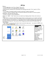
Quitting the
program:
Press Q for Quit.
If you do not have a
keyboard touch
Menu then “Quit this
Application.”
Make NEZ, DXF, and Zip all to Ext.Dest.
Backup the job to Ext.Dest.
Zip CTL and SVY files to a "NEW" ZIP file.
Zip up whole job (TOPO1.* to TOPO1.zip)
Copy TOPO1.ZIP to Ext.Dest.
Make an NEZ File.
Make a CSV File (an NEZ but comma-separated).
Make NEZ, DXF, and Zip all to Ext.Dest.
3D Visualization of the Data.
----- Scroll for other actions above ----Volume and Area Comparison using Surfer(tm).
Contour Map
made using Surfer(tm).
3D Visualization
using Surfer8(tm) ...
Land-Leveling, make gridded .NEZ file.
External Destination for use above = D:
Run utility : c:\amw\data\mikec.bat
Utility specification for above
Capture a control point here ...
Do NOT Quit, Continue working.
Quit now.
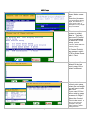
Next you receive a
scrollable menu with
data preparation
options before
quitting, or you can
“Quit now”.
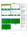
“Make an NEZ file”
if you want a text file
of the data.
If you have Surfer™
installed, you can
produce an instant
“Contour Map”.
For “land-leveling”
you can grid an
NEZ and launch
GradePlane™ (if
installed)
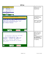
When you select
“Quit Now” you will
be taken to the Main
Menu. If you are
done with
everything you can
“Quit and Shutdown
computer”
To work with another
application scroll up to
select it.
Select Quit for the
desktop.
Page 11 of 12
Revision: 10/5/2009