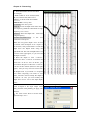
1
User’s Manual
POWER NAV®
STONEX Ltd.
www.stonexsurveying.com
[email protected]
CONTENT
1. Introduction
-1-
I. Welcome to POWER NAV® .............................................................................. - 1 II. POWER NAV® Minimum System Requirements ......................................... - 2 III. Installation....................................................................................................... - 2 IV. POWER NAV® Interface ............................................................................... - 3 A. POWER NAV® Icon Bar.................................................................. - 4 B. POWER NAV® Information List...................................................... - 7 C. POWER NAV® Depth Window ..................................................... - 11 D. POWER NAV® Information Tab with Information Window ........ - 12 E. POWER NAV® Information Bar .................................................... - 13 -
2. Preparation
- 14 -
I. New Project Guide…………………………………………………………...- 14 II. Import Coordinates to X/Y Library (Optional) .......................................... - 21 III. Geodesy……………………………………………………………………..- 24 A. Geodetic Parameters Program ........................................................ - 24 B. Calculating Conversion Parameters................................................ - 26 IV. Defining Work Area...................................................................................... - 30 V. Planned Survey Lines..................................................................................... - 31 A. Common Patterns for Planned Lines .............................................. - 32 B. Offset Patterns for Planned Lines ................................................... - 33 C. Creating Planned Lines................................................................... - 34 D. Creating Points and Text Remark................................................... - 42 E. Creating Arc.................................................................................... - 44 F. Creating Planned Lines in Channel Design..................................... - 44 G. Creating a Planned Line File from a DXF File............................... - 46 VI. Boat Shape Design…………………………………………………………- 46 A. Boat Shape Editor........................................................................... - 46 B. Creating a Boat Shape..................................................................... - 47 VII. Hardware Setup in POWER NAV® ........................................................... - 48 A. Connection Information in POWER NAV® ................................... - 50 B. Disabling Devices in the POWER NAV® ...................................... - 52 C. Editing Device Settings in POWER NAV® .................................... - 53 VIII. Hardware Notes………………………………………………………….- 53 A. GPS Positioning Equipment ........................................................... - 53 User’s Manual
I
B. Echosounder ................................................................................... - 58 IX. Preparing for Collecting Data...................................................................... - 60 A. Collecting Basis.............................................................................. - 60 B. Storage Settings .............................................................................. - 62 X. RTK………………………………………………………………………… - 63 A. Base Station GPS Settings.............................................................. - 63 B. Ship-based GPS settings ................................................................. - 65 -
3. Survey
- 67 -
I. Boat Shape……………………………………………………………………- 67 II. Recording Survey Data .................................................................................. - 69 A. Description ..................................................................................... - 69 B. Questions ........................................................................................ - 70 III. Survey Line………………………………………………………………...- 73 A. Selecting Line................................................................................. - 73 B. Lofting Information for Selected Line............................................ - 74 C. Changing Line Direction ................................................................ - 75 IV. Point Selection……………………………………………………………- 75 A. Selecting Point................................................................................ - 76 B. Alarm Settings ................................................................................ - 77 V. Pausing and Resuming ................................................................................... - 78 -
4. Processing
- 79 -
I. Previewing Your Data in the Main Window ................................................. - 79 II. Sounding Editor…………………………………………………………….- 80 A. Instruction....................................................................................... - 80 B. Editing Data in the Editor ............................................................... - 83 C. Setting Selection Method................................................................ - 87 D. Saving Edited Data ......................................................................... - 91 E. Questions......................................................................................... - 91 III. Tide File……………………………………………………………………- 92 IV. Merging Corrections..................................................................................... - 95 A. Setting Data Format of Exported Files ........................................... - 96 B. Importing DEP files ........................................................................ - 99 C. Corrections.................................................................................... - 100 D. Correcting DEP Files.................................................................... - 105 -
User’s Manual
II
Chapter 1 - Introduction
1. Introduction
I. Welcome to POWER NAV®
POWER NAV®
Interface
Welcome to POWER NAV®. This manual provides
details regarding the modules of POWER NAV®. It
contains the sections regarding:
•
Survey Preparation,
•
Final Products
•
Data Collection,
•
Utility Functions
•
Single Beam Processing,
•
DREDGEPACK®.
If you have purchased a POWER NAV® license, you will
receive an additional manual specific for surveys.
POWER NAV® is delivered with different modules,
depending on which package you ordered. Different
modules include:
User’s Manual
Module
Packages Included
Survey Module
Preparation and Data Collection
-1-
Chapter 1 - Introduction
Module
Packages Included
Processing Module
Editing and Reduction of Side Scan
Data
DREDGEPACK® Module
Monitoring and data collection
specialized for dredge operations
II. POWER NAV® Minimum System
Requirements
POWER NAV®
Operating System
Windows 2000, Windows XP
Pentium Coprocessor
500 MHz
RAM
256Mb RAM
Minimum
Serial
Interface
Laptop
PCMCIA to Serial
Desktop
PCI to Serial
1 GB
Hard Drive
Monitor
Resolution
Colors
POWER NAV® Hardlock Key
(Software Dog)
800X600
32-bit
POWER NAV® will run in demo mode
without a hardlock key. Hardlock keys are
made for USB.
III. Installation
POWER NAV® is delivered on a CD-ROM. To install the
package, place the CD-ROM in your CD-ROM drive. If
you are using Windows® XP or Windows® 2000, you must
be in administrative mode and have the password to
proceed with the hardlock installation.
Double click the “Setup.exe” file from the CD-ROM
Directory. The installation program will begin. Follow
the on-screen directions until the screen says the installation
is complete.
User’s Manual
-2-
Chapter 1 - Introduction
Note: You cannot properly install the package by copying
files from one computer to another. Many of the programs
need to be registered in the Windows® Registry and will not
operate unless they have been installed using the normal
installation routine.
IV. POWER NAV® Interface
POWER NAV® User Interface (Main Program)
All of the programs of POWER NAV® can be accessed
from the unified user interface.
Programs can be started from either the icon bar or from the
menu bar.
Note: If you launched POWER NAV® without hardlock
attached, you can attach your hardlock then restart the
software. When POWER NAV® detects the key, the
corresponding programs will be enabled.
Located along the top of the screen, the menu bar selections
are grouped into basic functional areas.
User’s Manual
-3-
Chapter 1 - Introduction
A. POWER NAV® Icon Bar
The icon bar quickly starts programs with a click on the
icon. If you leave the cursor on top of an icon for a second,
a text box will appear which describes the function of the
icon.
POWER NAV® Icon Bar
The Icon Bar enables you to quickly access various
POWER NAV® functions and programs. As with all icon
bars in POWER NAV®, the function of each icon can be
displayed by moving the cursor over it.
File Operation
New can bring up a New/Open project dialog.
Open can bring up a New/Open project dialog.
Save tells program to save all figures
Adjusting the Area
Map View
Zoom In tells POWER NAV® to zoom in the screen center.
Zoom Out tells POWER NAV® to zoom out the screen center.
Zoom Window changes the cursor to cross. You can then
click-and-drag an area on the Area Map and POWER NAV®
will zoom in on the area. Right clicking on the Area Map can
exit the program.
Zoom Extents tells POWER NAV® to zoom to fit all of the
current files into the view window
Zoom Scale tells POWER NAV® to zoom according to the
scale of the Work Area (about the Work Area, refer to the
Defining Work Area section in the Prepare chapter).
Pan invokes the pan tool. You can click-and-drag a line on the
Area Map and POWER NAV® will move to the end point of the
line.
Switching
Displayed
Information
User’s Manual
Switch Displayed Information tells POWER NAV® to switch
displayed area along the left-hand side from Information List
to Depth Window or from Depth Window to Information List.
-4-
Chapter 1 - Introduction
Drawing figures
Draw Reference Point can bring up a Select Drawing Mode
dialog. And you can select a drawing method, basing the
selected method, and then create the point on the Area Map by
left clicking at the point on the area or by inputting necessary
information about the point. When using cursor method, you
can right click on the Area Map to exit the program.
Draw Line can bring up a Select Drawing Mode dialog. And
you can select a drawing method, basing the selected method,
and then draw the line on the Area Map by left clicking at
start point and end point on the area or by inputting necessary
information about the line. When using cursor method, you
can right click on the Area Map to exit the program.
Draw Polyline can bring up a Select Drawing Mode dialog.
And you can select a drawing method, basing the selected
method, and then draw the polyline on the Area Map by left
clicking at waypoint on the area in series with end of clicking
right- button or by inputting necessary information about the
polyline. When using cursor method, you can right click on the
Area Map to exit the program.
Draw Arc can bring up Arc Attribute dialog. And you can input
the necessary information and then click [ OK ] to create a arc
on the Area Map.
Text Remark can bring up a Select Drawing Mode dialog. And
you can select a drawing method, basing the selected method,
and then add a text on the Area Map via clicking a point on the
area or inputting necessary information about the arc.
Node Snap
Node Snap is switched on. And the POWER NAV® can snap
points, waypoints, and nodes of other figure when drawing
figures by cursor. (Note: If the Node Snap function is of no use,
the reason maybe is that the function has not been perfect)
Logging Control
Connect Equipment tells POWER NAV® to create the
connection between the software and equipments. And you can
get the result information of connecting them form the
Information Tip Window at bottom of the Area Map.
Start Logging tells POWER NAV® to log correct data.
Pause Logging tells POWER NAV® to pause.
User’s Manual
-5-
Chapter 1 - Introduction
End Logging tells POWER NAV® to stop logging data and cut
the connection between the software and equipments.
Alternating
Planned Line
Direction and
Selecting Planned
Line
Alternate Line Direction tells POWER NAV® to alternate
between the start point and end point of selected line. Note: the
Alternate Line Direction maybe is not enabled when the Select
Line is not enabled.
Select Line invokes the selection tool. And the cursor becomes a
small pane. So you can left click on the target line, an assured
dialog is brought up, and then click [OK] as you make sure it is
right after viewing its attribute. If the line is selected
successfully, the line is shown with high light. Right clicking on
the Area Map can exit the program. Note: the Select Line
maybe is not enabled, and you can click SURVEY-LOCK
PLANNED LINE and click [OK] to make it enabled.
Select Point
Select Point invokes the selection tool. And the cursor becomes
a small pane. So you can left click on the target point, an
assured dialog is brought up, and then click [OK] as you make
sure it is right after viewing its attribute. Right clicking on the
Area Map can exit the program. Note: 1. The point which is
selected must be single point. 2. The Select Point maybe is not
enabled, you can click SURVEY-POINT LOFTING and click
[Start Lofting] to make it enabled.
Watching
Azimuth and Distance changes cursor to cross. And you can
get distance between two point and angle from grid north from
start point to end point via clicking and dragging a line. The
distance and angle is shown at the bottom of user interface.
Right clicking on the Area Map can exit the program.
Watch Attribute changes cursor to selection tool. And the
cursor becomes a small pane. You can select an object, and the
object’s attribute dialog is brought up. And then you also can
modify attribute of the object as you read the information about
the attribute. Right clicking on the Area Map can exit the
program. Note: When the object is arc, some information about
its attribute maybe is only read and can’t be modified.
Adjusting Object
User’s Manual
Move Single Target changes cursor to selection tool. And the
cursor becomes a small pane. You can left click on a single
object and the object is shown with high light, if the point you
click on is not waypoint of the object, and then move the cursor
to target position and left click to complete the action of moving
the object in parallel; if the point you click on is waypoint of the
-6-
Chapter 1 - Introduction
object (e.g. line and polyline), the waypoint is locked with red
rectangle, and then move the cursor to target position and left
click to complete the action of moving the waypoint. Right
clicking on the Area Map can exit the program. Note: There is a
dashed between target position and point on the object when the
object is selected with high light and the target position is
valuable.
Delete Single Target changes cursor to selection tool. And the
cursor becomes a small pane. You can left click on a single
object, the assured dialog is brought up, and then click [OK] to
make sure your decision of deleting the target. Right clicking on
the Area Map can exit the program.
Delete Area’s Targets changes the cursor to cross. You can
click-and-drag an area on the Area Map, an assured dialog is
brought up, and then select the types of objects which you want
to delete in the area and click [OK] to be sure your decision.
Note: The objects are looked as what you want to delete by the
program even if the area you click-and-drag may only contain
portion of the objects.
Delete All Targets brings up an assure dialog, and then select
the types of objects which you want to delete in the Area Map
and click [OK] to be sure your decision.
About Current
Software
About POWER NAV brings up an information box. From the
box, you can get version number, limit time, website, and
e-mail. And the box is hidden after left clicking on it.
B. POWER NAV® Information List
Along the left-hand side of the user interface you will see
an information spreadsheet. From here you can bring up the
configuration dialog to control which contents are displayed
in the table via double left clicking on the list, and to
configure the list (e.g. Font Size and Color).
Note: If the Information List is not displayed along the
left-hand side of the user interface, you can click Switch
Displayed Information icon or VIEW-INFORMATION
LIST to bring it out.
User’s Manual
-7-
Chapter 1 - Introduction
Information Displayed in List
The contents the right figure shows is the default
configuration.
Solution: Single/Difference/Floating/Fixed
Status: the state of signal coming from GPS receiver
PDOP: position dilution of precision
Stas: the number of satellites which are used.
Time: the location time in 24 hour system
Hdg: the course of boat navigate
Speed: the velocity of boat navigate
Line: the current track line name/ID
Point ID: ID of event point on current track line
Spacing: distance between current point and latest point
Depth: (if echo sounder is connected) current position
water depth
Northing/Easting/Height: corrected grid coordinates of
current survey point
Latitude/Longitude: corrected geodetic coordinates of
current survey point
Ellip.H: height of projection ellipsoid
User’s Manual
-8-
Chapter 1 - Introduction
Data Display Configuration
Configuration Dialog
Caption: You can define a
caption of a team of items via
inputting the content and clicking
[>>] button.
Content: You can left click on an
item in the left list, and then click
[>>] button to add it into right
list.
Display: the contents in right list
will be shown in Information List.
1. Modify: Only caption can be
modified. And you can select
a caption in the Display list,
input new caption in the
Caption edit box, and then
click [Modify] button to
perform the action.
2. Up/Down: You can select an
item in the right list and then
change the order of items via
clicking [Up]/ [Down] button.
3. Delete: You can select an
item in the right list and then
delete the item (Caption or
Content) via clicking [Delete]
button.
4. Clear: You can clear all items
Color Box
in the right list.
Font Settings: You can
respectively select the font type
and font size of captions and
contents from the two drop-down
boxes.
Color Settings: The color
buttons will display the
current settings. You can
click the color button, the
color box pop up, and then
select a color from it. When
User’s Manual
-9-
Chapter 1 - Introduction
cursor is on the grid of Color
Box, the current point color
is displayed on the left-end
corner of Color Box. And
you can click the button on
the right-end corner of Color
Box, the colors dialog
appears, and then select the
new color and click [OK].
You will see the results in
the display at the right. If
you don’t like them, try
again.
User’s Manual
Colors Dialog
- 10 -
Chapter 1 - Introduction
C. POWER NAV® Depth Window
Usually, the Depth Window is hidden behind the
Information List, and can be displayed via clicking Switch
Displayed Information icon or VIEW-DEPTH WINDOW.
Information Displayed in Depth Window
Water Surface Height: the height of current water
surface
Log File: the name of the file which stores survey data
of current track line including Latitude/Longitude,
Northing/Easting, Depth, and so no
Point ID: the ID of event point on the current track line
HDOP: horizontal dilution of precision
VDOP: vertical dilution of precision
HRMS: horizontal root mean square
VRMS: vertical root mean square
Eyeable: the number of satellites which are eyeable to
GPS receiver
Locked: the number of satellites which are being used
by GPS receiver
Satellites Display: the satellites will are displayed in
the view (i.e. cirque with cross in Depth
Window).
Depth Curve: This area shows a moving
representation of the depth value coming from
echo sounder. The display moves from right to left.
And the horizontal ruler marks represent the
distance in meter and the vertical ruler marks
represent the depth in meter.
User’s Manual
- 11 -
Chapter 1 - Introduction
D. POWER NAV® Information Tab with Information Window
Info. Tip
You can get tip from the window, know of the status or find out the reasons of
errors.
Navigation Info.
From the window, you can get the boat velocity and offset angle. And The
left-right indicator shows the distance of your vessel left and right from a
planned line.
Lofting Info.
Lofting Information for Selected Line
When a planned line is locked by manually/automatically selecting, the program will start lofting
line. From the window, you can know the follows: Current line name is “0”. XTE (Cross Track
Error): the distance from current GPS survey point to planned line (e.g. R85.494m means that
current GPS survey point is at the right side of the planned line and 85.494 meters far from it.).
Yaw Angle: the angle from boat course from planned line’s start point to its end point. DTSP
(Distance to Start Point): the distance from current GPS survey point to start point of planned
line. DTEP (Distance to End Point): the distance from current GPS survey point to end point of
planned line. Delta X/Y: the difference between current GPS survey point X/Y and the point X/Y
of current GPS survey point’s projection on planned line (or extended planned line).
Note:
XTE2, Yaw Angle2, DTSP2, DTEP2, Delta X/Y2 and so on are associated with GPS2 (the other
GPS).
User’s Manual
- 12 -
Chapter 1 - Introduction
Lofting Point
When a point is locked by manually selecting, the program will start lofting
line. From the window, you can know the follows: Current point name is “0”.
Northing/Easting/Height: the current survey point’s position information.
Delta X/Y/H: the difference of X/Y/H between locked point and current GPS
survey point. Tgt Bearing (Target Bearing): the angle from grid north from
current GPS survey point to current target point (i.e. locked point). Tgt Dist
(Target Distance): the distance from current GPS survey point to target point.
Tgt Time (Target Time): the time needed for boat arrive at target position.
Echo sounder
When the echo sounder is running, after set the right COM port and other
parameters for echo sounder in Power nav, then when you choose echo
sounder in Information Tab, it will show the depth curve real time..
E. POWER NAV® Information Bar
The Information Bar displays the current cursor position in
X/Y. Click the Azimuth and Distance icon, and then drag
your cursor across the Area Map and the distance and
azimuth are displayed on the middle of the Information
Bar.
The number of the data byte that POWER NAV® receives
from GPS and Echosounder is displayed on the right end of
the Information Bar.
User’s Manual
- 13 -
Chapter 2 - Preparation
2. Preparation
I. New Project Guide
When the POWER NAV® is launched, a new project
guide dialog pops up. And you can finish the project
settings in the guide of the dialogs.
Note: The guide only helps you finishing main survey
factors. And some factors, such as GPS Offsets, Antenna
Height, and Storage Setting, can be set in the way of menu
bar after you finish the guide.
Project Name
Create Project:
Select [Create a project] and input a folder name. And there
will be configuration files, collected data files, graphics files,
and resulting files and so on under the folder.
Copy Project:
Select [Copy an existing project] having inputted the folder
name in the edit box, and then click [OK]. And the Select a
User’s Manual
- 14 -
Chapter 2 - Preparation
Project dialog pops up, and you can select a project file with
the .tak/.pak/.spj extension.
Open Project:
Select [Open a project] and then select an item in the list. You
can open a project in manner of dblclick the item or clicking
[OK]. If the project file path does not exist in the list, you can
dblclick the item named Other Position and then select project
file via the pop-up Open Project dialog.
Basic Information
Input Basic Information:
You can input information such as project name, your
company, work area, survey date, and surveyor.
Note1: You may receive a message box to tell you to input
project name again when a same project name exists at the
same path.
Note2: If you run Power nav on echo sounder, you must save
your data or set up software on Disk D: instead of the default
path C:, because the C disk is protected from data written, that
means when you reboot the echo sounder, all the data you have
saved or written to C: will lost.
User’s Manual
- 15 -
Chapter 2 - Preparation
Projection
Select Ellipsoids and Projection:
1. Select your Ellipsoid from the choices in the ellipsoid list
box. As soon as you make your selection, the
Semi-Major Axis (a) and Flattening (1/f) values will
change. If your ellipsoid is not in the list, click on the
User-defined choice and manually enter the (a) and (1/f)
values.
2. Select your projection from the available projections. In
POWER NAV®, the following projections are supported:
Gauss-Kruger, UTM, Transverse Mercator, Oblique
Stereographic, and Equatorial Stereographic.
3. The Central Meridian, False Northing, False Easting,
Scale Factor, Projection Height, and Reference Latitude
pertinent to your chosen projection should be set.
Note: The Central Meridian should be inputted, because
different central meridian correspond to different zone. And
you can get local central meridian from local longitude.
User’s Manual
- 16 -
Chapter 2 - Preparation
Conversion
Conversion Parameters:
1. Specifying No Datum Transformation
If you do not want POWER NAV® to perform a datum
transformation, make all selection boxes not pitched on. This
flags the program about your intent.
2. Specifying a 4-Parameter Datum Transformation
POWER NAV® can perform a 4-parameter datum
transformation. The values, dX, and dY represent the
separation between the geocentric coordinate systems of the
two data. The 4-parameter transformation also contains values
for rotation about Z-axes, and changes in scale between the
two systems. There are many sources for these values. If you
have 4-parameter, you can select the [Use Four Parameters],
the input boxes become accessed to, and input parameters.
POWER NAV® uses these parameters to compute geographic
positions on the local datum. If you don’t have the 4-parameter
and have a minimum of two point pairs, you can set the
parameters
via
clicking
SETTINGS-CALCULATE
CONVERSION PARAMETERS menu to start Calculate
Conversion Parameters program after finishing the guide.
3. Specifying a 7-Parameter Datum Transformation
POWER NAV® can also perform a 7-parameter datum
transformation.
In addition to dX, dY and dZ, the
7-parameter transformation also contains values for rotations
about the X, Y and Z-axes, and changes in scale between the
two systems. Seven-parameter datum transformations can
cover a larger area more accurately than 4-parameter
transformations.
Certain countries have published
7-parameter transformation values that are to be used for the
User’s Manual
- 17 -
Chapter 2 - Preparation
entire country. If you have 7-parameter, you can select the
[Use Seven Parameters], the input boxes become accessed to,
and input parameters.
4. Specifying Adjustment Parameters Datum Transformation
Adjustment parameter datum transformations work well over a
local area. To perform these, you must enter the offsets
between the two survey data. The values, dX, dY, and dZ
represent the separation between the geocentric coordinate
systems of the two data. If you know the X/Y/Z of a single
point in the ellipsoid system that you have selected and the
local datum that you specify temporarily, you also can set the
parameters
via
clicking
SETTINGS-CALCULATE
CONVERSION PARAMETERS menu to start Calculate
Conversion Parameters program after finishing the guide. If
you have adjustment parameters, you can select the [Use
Adjustment Parameters], the input boxes become accessed to,
and input parameters. POWER NAV® will use these
parameters to transform your geographic position in real time.
Note: The instruction of the Calculate Conversion Parameters
program can be found in Geodesy section. And you don’t need
to worry that some parameters can’t be specified now, because
the POWER NAV® support these parameters input after the
guide is finished.
Equipment
Equipments Connection Information:
1. Specifying Configuration of GPS Receiver
A. Specifying Type and Data Format
Select the type of GPS receiver you are using from Type
drop-down list, and then from Data Format drop-down list
select the data format which the receiver output data in. In
User’s Manual
- 18 -
Chapter 2 - Preparation
POWER NAV®, the following GPS receivers are supported:
Stonex S86,Astech Receiver, Novatel Receiver, South S82,
South S80, South 9800, South 9300, South 9700, Javad
Receiver and other receiver.
B. Serial Port Configurations
The Serial connections (Baud Rate, Data Bits, Stop Bits and
Parity) maybe are explained in detail in your GPS device
manual. It is enough to mention here that they must be set to
match your equipment or POWER NAV® survey system can’t
read the device data.
2. Specifying Configuration of Echosounder (Optional)
If echosounder is used, select the [Use] selection and can
access to the edit boxes.
A. Specifying Type
Select the type of the echosounder you are using from the
drop-down list. In POWER NAV®, the following echo
sounders are supported: WuXi SDH-13D, WuXi HY1600,
WuXi ECHOTRAC, ODOM Single Frequency, ODOM
Double Frequencies, Stonex echo Sounder, DESO25,
NMEA0183-DBT, NMEA0183-DBS, WuXi SDE-88I, and
WuXi SDE-88II.
B. Serial Port Configurations
About the Serial connections, you can refer to the instruction
in your device manual.
Note: Computers require more communication ports (COM1
COM2, etc) than are available on a standard PC. Expansion
cards are available from STONEX and many other vendors. The
only requirement is that the vendor supplies a working,
Windows® 2000, or Windows® XP driver with the card.
USB is designed to give priority to Windows® functions. This
can result in extreme and inconsistent latency issues for USB
to Serial connectors. You cannot rely on these for time-critical
data. For desktop PCs, we recommend PCI type boards like
the ones from Comtrol to Digi. For notebooks we recommend
PCMCIA to serial cards like those from Quatech to Socket.
User’s Manual
- 19 -
Chapter 2 - Preparation
Collecting
Collecting Data Basic:
1. Specifying the Basic of Collecting Data from GPS
Receiver
A. Solution Status:
z Single:
When the data coming from GPS receiver don’t contain
difference received from the Basestation or Beacon, the
solution is single, and, if specifying the basic on Single, the
collecting program will perform collecting and saving the data
without difference.
z Difference(RTD):
When the data coming from GPS receiver contain difference
received from the Basestation or Beacon and HRMS and
VRMS are out of the precision limit, the solution is differential,
and, if specifying the basic on Difference, the collecting
program will perform collecting and saving the data with
difference.
z Fixed(RTK):
When the data coming from GPS receiver contain difference
received from the Basestation and HRMS and VRMS are in
the precision limit, the solution is fixed, and, if specifying the
basic on Fixed, the collecting program will perform collecting
and saving the data.
Note: If you specify the basic on Single, the collecting
program will perform collecting and saving the data only just
the solution is single or differential or fixed. If you specify the
basic on Difference, the collecting program will perform
User’s Manual
- 20 -
Chapter 2 - Preparation
collecting and saving the data only just the solution is
differential or fixed. If you specify the basic on fixed, the
collecting program will perform collecting and saving the data
only just the solution is fixed.
B. Event:
The Event occurs at every specified value (time interval or
point spacing). POWER NAV® also supports controlling the
event manually by pressing Space Key. When an event occurs,
the collecting program will perform collecting and saving the
current position data and sending a command to Echosounder
to make event mark for getting the current position depth (if
echosounder is used and connected).
Note: The GPS receiver only can output a set of data into
POWER NAV® every one second. So it is not available that
the Time Increment is specified less than 1 second or the Dist
Increment is specified too little.
2. Specifying the Basic of Collecting Data from Echosounder
(if the Echosounder is being used)
Usually, the Collect Depth basic is specified on Instantaneous
Depth. In this case, the depth value which is collected and
saved by collecting program is real and not processed
factitiously. When the Collect Depth basic is specified on
Max/Min Depth, for collecting and saving current position
depth, the collecting program will select a Max/Min depth
value from recent depth values those collecting program has
obtained. When the Collect Depth basic is specified on
Average Depth, for collecting and saving current position
depth, the collecting program will get a mean via computing
recent depth values those collecting program has obtained.
3. Specifying the File Name of Collecting Data
The Name is the first name of the files of track lines, and you
can specify it. Each file’s last name is ID of its track line. For
example, the Name is “Ln” and a track line’s ID is “0”, then
the track line file’s name is “Ln0”.
When you complete above settings, click [OK] to make
your decision available and then continue to do other
preparative work.
II. Import Coordinates to X/Y Library (Optional)
You may have many useful coordinates for the Project,
and some of them may be used in the Project. For
example, computing 4-parameter and adjustment
parameters need some coordinates, and, creating planned
User’s Manual
- 21 -
Chapter 2 - Preparation
lines also need a lot of coordinates. So importing your
coordinates to X/Y library may be necessary. You can
bring up the X/Y Library dialog by clicking
UTILITIES-X/Y LIBRARY.
X/Y Library dialog
Actions:
a) Add
Click [Add] to bring up the Add Point dialog, and enter
necessary information to the editable boxes.
Add Point dialog
Enter a point name and X/Y/H of the point. And the
Code flags the point’s sort.
b) Edit
User’s Manual
- 22 -
Chapter 2 - Preparation
Select a point item in the listing, and then click [Edit] to
bring up the Edit Point dialog. You can edit X/Y/H and
the code of the point.
Edit Point dialog
c) Delete
If you want to delete a point, select the point item in the
listing, and then click [Delete], an ensured message box
pops up, and click [OK] to insure your decision
d) Clear
If you want to clear all points in the listing, click [Clear],
an ensured message box pops up, and click [OK] to
insure your decision
e) Search
The Search function can help you to find the wanted
point from the library quickly. Click [Search] to bring up
the Search Point dialog.
Search Point dialog
User’s Manual
- 23 -
Chapter 2 - Preparation
You can enter portion of point name, and then click
[Search], and resulting point names are shown in the
listing along left of the Search Point dialog. And select
the name of your wanted point from the listing and click
[OK]. And your wanted point item is selected in the X/Y
Library listing.
f)
Load
You can click [Load] to add a batch of points from data
file with ORG or DAT extension.
g) Export
You can export all the point coordinates in the listing to a
file with DAT extension.
h) OK
You can click [OK] to insure your decision
III. Geodesy
Geodesy is the science of positioning objects on the earth’s
surface. Even though you don’t need to be a “master of
geodesy” to run POWER NAV®, some basic geodetic
knowledge can make the difference between obtaining a
correct position and having your boat plot downtown.
Many surveys are now conducted using GPS for positioning.
Most GPS equipment outputs your position in WGS-84.
→ ΦΛHLocal Datum
→ XYProjection
ΦΛHwgs-84
®
In other words, POWER NAV receives the Latitude,
Longitude and Height information based on the WGS-84
ellipsoid, and transforms it into a Latitude, Longitude and
Height on the Local Datum. It then performs a “Grid
Conversion” to calculate an X (Easting) and Y (Northing) on
the specified projection.
A. Geodetic Parameters Program
To correctly determine your X-Y position, you must be able
to define:
User’s Manual
•
The reference ellipsoid
•
Any necessary datum transformation parameters
•
The projection parameters
- 24 -
Chapter 2 - Preparation
You may have finished these parameters in the Guide. If
wanting to see or redefine these parameters after finishing
the Guide, you can do as follows:
1. Start the GEODETIC PARAMETERS program by
clicking SETTINGS-GEODETIC PARAMETERS. The
Geodetic Parameters dialog will appear. And the displayed
parameters are that you have set in Guide.
Geodetic
Parameters Dialog
2. Redefine Configuration (if necessary) by selecting new
Ellipsoid and Projection and inputting new values (e.g.
Central Meridian, Four Parameters, Seven Parameters, and
Adjustment Parameters).
You can find only the Interpolation Parameters doesn’t
appear in the Guide. And this section will explain it in
detail.
As we know, global positioning system (GPS) can be used
to get precise relative position in a three-dimensional
system. The results of many field-test and applied projects
have already shown that GPS survey method can take the
place of classical horizontal terrain survey method. But
how to interpolate the abnormal height of GPS leveling, so
as to take the place of classical leveling survey method, has
attracted many geodesists in the past ten years. Up to now,
a lot of methods have been discussed and applied.
According to the development of GPS height abnormal
height interpolation system (GANHIS), POWER NAV®
uses the Polynomial Curved Surface Interpolation method.
User’s Manual
- 25 -
Chapter 2 - Preparation
Abnormal Height Interpolation
System Parameters Dialog
For getting precise height, it is needed to compute the
height separation (i.e. dH) between the geocentric
coordinate systems of the two data. If you know the
Latitude/Longitude/Height of more than two point pairs in
WGS 84 and the local datum, you can get a set of the
Interpolation Parameters (i.e. A0, A1, A2, A3, A4, A5, X0,
Y0) by running POWER NAV® Calculate Conversion
Parameters program to calculate the necessary values. And
POWER NAV® uses the following Abnormal Height
Interpolation System formulas to compute the height offset.
dH= A0+A1×dx + A2×dy+A3×(dx)2+A4×(dy)2+A5×
dx×dy,
and, dx= x-X0, dy= y-Y0,
and, X0= AVG (x1, x2, x3, …), Y0= AVG (y1, y2,
y3, …)
Note: “AVG(x1, x2, x3, …)” is average of “x1, x2, x3, …”.
And then POWER NAV® uses the dH to compute
geographic height on the local datum.
B. Calculating Conversion Parameters
The CALCULATE CONVERSION PARAMETERS
program calculates adjustment parameters or four
parameters or interpolation parameters from coordinate
information listings. And you can calculate seven
parameters via using Calculate Tool which can be found in
the software CD. These values translate your position data
User’s Manual
- 26 -
Chapter 2 - Preparation
from the WGS-84 position to the corresponding position on
your local datum. The adjustment parameters calculation
requires only one point described in each datum. The four
parameters calculation requires a minimum of two point
pairs. And interpolation parameters calculation requires a
minimum of three point pairs.
The program will calculate conversion parameters basing
on the number of the point pairs you input, and offer to
apply them in the Geodetic Parameters program.
Conversion Parameters Comparison Table
Translated Target Application
Name
Required
Points
Seven
Parameters
More than two
X/Y/Z
The position translation between two
different projection ellipsoids
Four
Parameters
More than one
X/Y
The grid translation between two
different local datum
Interpolation
Parameters
More than two
H
The height translation between two
different local datum
Adjustment
Parameters
one
X/Y/H
The coordinates translation between
two different coordinate systems
Set your ellipsoid and projection information in the
GEODETIC PARAMETERS program (if you have set
them in the Guide, this step is not necessary).
1. Launch the CALCULATE CONVERSION
PARAMETERS program by selecting SETTINGSCALCULATE CONVERSION PARAMETERS. The
dialog will appear for you to enter your coordinates.
Calculate Conversion
Parameters Dialog
User’s Manual
- 27 -
Chapter 2 - Preparation
2. Add each point or points with two sets of
coordinates—one based on your local datum (i.e.
known coordinate) and the other in WGS84 (i.e.
original coordinate).
Note: Usually, each country may have some standard
coordinate systems and corresponding geodetic origins.
And your local datum may be one of these geodetic
origins or your specifying origin. And some position
coordinate may be described in standard system by the
government, and, you also can specify coordinate for
some control points basing on your specifying origin,
and these coordinates are saw as the known coordinates.
GPS receiver uses WGS84 system, and the coordinates
exported from the receiver are saw as original
coordinates.
a) Add known coordinate by clicking [Add]. And input
known coordinate information. Click [OK] to next step.
Add Known Coordinate
Description
X/Y Library
You can input the
X/Y/H and point name
by keyboard. If you
want to add the X/Y/H
from the X/Y library,
you can click the icon at
right-top corner of the
dialog to bring up the
X/Y library interface,
and then select an item
in the list and click
[OK].
User’s Manual
- 28 -
Chapter 2 - Preparation
b) Add Original Coordinate: there are four methods to add
original coordinate. You can select one of them to add original
coordinate.
Adding Method
Description
Get from X/Y library: click this icon to bring up the X/Y
library interface, and then select an item in the list and
click [OK].
Get current Point Coordinate: click this icon to read the
coordinate at the GPS antenna from the ship-based GPS
receiver which is connected with POWER NAV®. So you
must insure right connection between POWER NAV® and
the ship-based GPS receiver before you click this icon to
get the coordinate.
Get Basestation Coordinate: click this icon to read the
coordinate at the Basestation from the ship-based GPS
receiver.
Input geography Coordinate: click this icon to bring up
an input dialog, and then input Latitude/Longitude/Height
and click [OK], and then the program translates the
Latitude/Longitude/Height into X/Y/H that is displayed in
the pop-up dialog.
3. Optional operations:
Open coordinate file: Click [Open] to bring up an Open
File dialog and you can open a file with *.cot extension.
Edit an item: Select an item in the list and then click
[Edit] to bring up an edit dialog. When you complete the
edit, click [OK] to apply it.
Edit Coordinate
Dialog
User’s Manual
- 29 -
Chapter 2 - Preparation
Delete an item: Select an item in the list and then click
[Delete]. A message box pop up, you click [OK] to insure
your decision.
Clear all items: Click [Clear]. And a message box pop up,
you click [OK] to insure your decision.
Set the number of points concerned with computing
the Interpolation Parameters: Click [Set] to bring up a
dialog, select number from two drop-down box, and click
[OK] to insure your decision. It is enough to mention here
that there are Curved Surface Height Interpolation and
Plane Surface Height Interpolation. Indeed, the Plane
Surface Height Interpolation is a special instance of the
Curved Surface Height Interpolation. And computing
Plane Surface Height Interpolation Parameters requires
more than two point pairs and computing Plane Surface
Height Interpolation Parameters requires more than five
point pairs. You may know that there are more points
concerned with computing the Interpolation Parameters
and the Interpolation Parameters become better.
4. Save the coordinates in the listing by clicking [Save].
A Save File dialog pop up and you can save the
coordinates into a file with *.cot extension.
5. Offer to apply all parameters in the Geodetic
Parameters program by clicking [On/Off].
6. Insure your decision by clicking [OK].
Note: When you use Calculating Conversion Parameters
program, you ensure that you have not used the four
parameters and the adjustment parameters in the Geodetic
Parameters Program, namely the selections of the four
parameters and the adjustment parameters are unchecked in
the Geodetic Parameters dialog. Or else the current
coordinates is the result of transmitted original coordinates
as using four parameters and adjustment parameters but not
original coordinates, and the error occur when you calculate
conversion parameters and obtain original coordinates by
the way of Get Current Point Coordinate or Get Base
Station Coordinate.
IV. Defining Work Area
You may work in a special area, and make all your
actions inside the area. And defining a work area is very
useful. You can click VIEW-WORK AREA to bring up
the Set Work Area dialog.
User’s Manual
- 30 -
Chapter 2 - Preparation
Set Work Area dialog
Xs/Yw: the coordinates of the
point on the left-below corner.
Scale: the scale of displaying
your work area.
Display Work Area Frame: If it
is selected, your work area will
be displayed with a frame.
Note: The Scale is applied only
when you click the Display 1:1
icon to tell POWER NAV® to
zoom according to the Scale.
When you want to cover the Area Map with the Work
Area in maximum or you can not find your Work Area,
you can click VIEW-MAXIMIZE WORK AREA to tell
POWER NAV® to zoom to fit the Work Area into the
view window.
V. Planned Survey Lines
Planned survey lines are used to define where you want the
vessel to go. Planned lines are most commonly created in
the programs, included in DESIGN-PLANNED LINE
PATTERNS, or in the CHANNEL DESIGN program. You
may also import Planned Lines from a DXF file.
Planned Lines are saved with an SG extension and are
normally saved in the project directory. Planned lines can
be created in a few programs, each with its own advantages.
Use the program that best fits your needs for the project.
User’s Manual
•
The programs, included in DESIGN-PLANNED LINE
PATTERNS, create planned lines that contain only
position coordinate information in
Northing/Easting/Height format. These programs only
enable you to create 2-dimensional lines.
•
The DESIGN-CHANNEL DESIGN program creates
planned lines only in a center line pattern.
•
The PROJECT-IMPORT DXF option can be used to
create Planned Line from DXF files that meet certain
requirements.
- 31 -
Chapter 2 - Preparation
You also can create any planned line while underway.
Although it is possible to collect survey data without
planned lines, it will make the survey process more logical
if you have referenced some kind of survey lines in your
area.
A. Common Patterns for Planned Lines
The DESIGN-DRAW LINE program can create single
line and DESIGN-DRAW POLYLINE program can
create single polyline. When you click DESIGN-DRAW
LINE or DESIGN-DRAW POLYLINE, the Select
Drawing Mode dialog pops up, and you can select cursor
method or coordinates method. You also can do these by
clicking Draw Line icon or Draw Polyline icon in the
Icon Bar.
Select Drawing
Dialog
Mode
Draw Line
create a line by
coordinates of
start position to
end position
User’s Manual
- 32 -
Chapter 2 - Preparation
Draw Polyline
create a line by
coordinates of
waypoints
B. Offset Patterns for Planned Lines
Planned lines can be created in any one of several patterns
included in the DESIGN-PLANNED LINE PATTERNS.
Parallel Line
Offsets create
parallel lines
on either side
of the initial
line.
Parallel
Polyline
Offsets create
parallel
polylines on
either side of
the initial line.
User’s Manual
- 33 -
Chapter 2 - Preparation
Center Line
Offsets create
perpendicular
lines at
user-defined
spacing along
the initial line.
Fan-shaped
Line Offsets
pivot your
planned lines
about the
Center Point.
Batch Lines
Offsets create
planned lines
in a closed
area.
C. Creating Planned Lines
To create Planned Lines:
1. Select a pattern for planned lines.
User’s Manual
- 34 -
Chapter 2 - Preparation
2. Define your Planned Lines using the coordinates or
cursor method.
3. Input defined information.
4. Save your Planned Line file by selecting FILE-SAVE.
Your data will be saved with a .SG extension to your
project directory.
1) Create Single Line
To create single line, select DESIGN-DRAW LINE or click
on the Draw Line icon. The Select Drawing Mode dialog
will appear and you can select a method.
a) Cursor Method
To specify the start point and end point of planned line, left
click in the Area Map. And a single line is created. And then
you can create next line until you right click to exit the Create
Line program.
b) Coordinates Method
You can define a planned line via entering necessary
information in the Line Attribute Dialog.
Line Attribute Dialog
Start X/Y: X/Y coordinate of
start point of the planned
line
End X/Y: X/Y coordinate of
end point of the planned line
Select: you can load a point
coordinate from the X/Y
Library
2) Create Single Polyline
To create single polyline, select DESIGN-DRAW
POLYLINE or click on the Draw Polyline icon. The
Select Drawing Mode dialog will appear and you can select
a method.
a) Cursor Method
User’s Manual
- 35 -
Chapter 2 - Preparation
To specify the waypoints of a polyline, left click in series in
the Area Map. And right click to ensure to create the
polyline. And then you can create next polyline until you
right click to exit the Create Polyline program.
b) Coordinates Method
You can define a planned line via entering necessary
information in the Polyline Attribute Dialog.
Polyline Attribute Dialog
Create a polyline:
1) Enter line name
2) Click [Add] to tell the program to
add an item into the listing.
3) Left click on the item, and enter
coordinates of the waypoint into the
spreadsheet.
4) Returns to 2) until all waypoints
of polyline are entered.
5) Set the line type, line width, and
color of polyline.
6) Click [OK] to insure your
decision.
Note: 2) to 4) can be replaced by
clicking [Select] to load point from X/Y
Library. And you can change the
sequence of the waypoints in the listing
by selecting an item and clicking [Up]
or [Down] to move it.
3) Create Batch Lines
To create a batch of parallel lines in a specified area, select
DESIGN-PLANNED LINE PATTERNS-BATCH LINES.
The Select Drawing Mode dialog will appear and you can
select a method.
a) Cursor Method
To specify the waypoints of the borderline of the specified
area, left click in series in the Area Map. And right click to
ensure the borderline and the Batch Lines dialog pops up. In
the dialog, you can modify the default value and edit the
coordinates with end of clicking [OK] to apply your
User’s Manual
- 36 -
Chapter 2 - Preparation
decision. And then you can create a batch of parallel lines
in next specified area until you right click to exit the Create
Batch Lines program.
b) Coordinates Method
You can define a borderline of the specified area via
entering necessary information in the Batch Lines Dialog.
Batch Lines Dialog
Direction Angle: the angle from the
Grid North to any line of the parallel
lines in the specified area.
Line Spacing: the spacing of the
parallel lines in the specified area.
Draw borderline: If this is selected,
the borderline of the specified area
will be drawn.
Up/Down: This is used to change
sequence of items in the listing.
Insert: This function can insert a
point as an item between the selected
item and its frontal item.
Steps:
1) Enter the value of the Direction Angle and the value of
the Line Spacing.
2) Enter point name and X/Y/H coordinates in the Input
Point Coordinates
3) Click [Add] to tell the program to add the point into the
listing as an item.
4) (Optional) Left click on the item, and modify
coordinates of the waypoint.
5) Return to 2) until all waypoint is entered.
6) Click [OK] to insure your decision.
Note: 2) to 4) can be replaced by clicking [Select] to load
point from X/Y Library.
4) Parallel Line Offsets
To create parallel lines on either side of the initial line,
select DESIGN-PLANNED LINE
PATTERNS-PARALLEL LINE OFFSETS. The Parallel
User’s Manual
- 37 -
Chapter 2 - Preparation
Line Offsets dialog will appear. And you can define an
initial line and offset values via entering necessary
information in the dialog.
Parallel Line Offsets
Point 1/Point 2: the node
of the initial line
Select: you can load a
point from the X/Y Library
Distance between lines:
the spacing with meter
unit between the parallel
lines
Lines right of center: the
number of lines at the
right side of the initial
line.
Lines left of center: the
number of lines at the left
side of the initial line.
Draw the initial line: If
this is selected, the initial
line is drawn.
Steps:
1) Enter the coordinates of the Point 1/Point2 or Select a
point from X/Y Library.
2) Enter the values in the Parameters Setting
3) Click [OK] to create parallel lines.
5) Parallel Polyline Offsets
To create parallel polylines on either side of the initial
polyline, select DESIGN-PLANNED LINE
PATTERNS-PARALLEL POLYLINE OFFSETS. The
Parallel Polyline Offsets dialog will appear. And you can
define an initial polyline and offset values via entering
necessary information in the dialog.
User’s Manual
- 38 -
Chapter 2 - Preparation
Parallel Polyline Offsets
Line Spacing: the spacing with
meter unit between the parallel
polylines
Lines right of center: the number
of polylines at the right side of the
initial polyline.
Lines left of center: the number of
lines at the left side of the initial
polyline.
Draw the initial line: If this is
selected, the initial polyline is
drawn.
Select: you can load a point from
the X/Y Library
Steps:
1) Enter the number of the polylines at right/left side of
the initial polyline and the value of the Line Spacing.
2) Enter point name and X/Y/H coordinates in the Input
Point Coordinates
3) Click [Add] to tell the program to add the point into the
listing as an item.
4) (Optional) Left click on the item, and modify
coordinates of the waypoint.
5) Return to 2) until all waypoint is entered.
6) Click [OK] to insure your decision.
Note: 2) to 4) can be replaced by clicking [Select] to load
point from X/Y Library.
6) Center Line Offsets
To create perpendicular lines at user-defined spacing along
the initial line, select DESIGN-PLANNED LINE
PATTERNS-CENTER LINE OFFSETS. The Center Line
Offsets dialog will appear. And you can define an initial
line and offset values via entering necessary information in
the dialog.
User’s Manual
- 39 -
Chapter 2 - Preparation
Center Line Offsets
Line Spacing: the spacing
with meter unit between the
parallel lines
Distance Port /Distance
Starboard: Imagine you are
standing at the start of the
initial line looking toward
the end to determine which
way is left or right (port or
starboard), the distance
with meter unit far away
from port/starboard.
Draw the initial line: If this
is selected, the initial line is
drawn.
Select: you can load a point
from the X/Y Library
Steps:
1) Enter values of the Distance Port and Distance
Starboard and the value of the Line Spacing.
2) Enter point name and X/Y/H coordinates in the Input
Point Coordinates
3) Click [Add] to tell the program to add the point into the
listing as an item.
4) (Optional) Left click on the item, and modify
coordinates of the waypoint.
5) Return to 2) until all waypoint is entered.
6) Click [OK] to insure your decision.
Note: 2) to 4) can be replaced by clicking [Select] to load
point from X/Y Library.
7) Fan-shaped Line Offsets
To pivot your planned lines about the Center Point, select
DESIGN-PLANNED LINE PATTERNS-FANSHAPED
LINE OFFSETS. The Fan-shaped Line Offsets dialog will
appear. And you can define inside and outside border arcs
and offset values via entering necessary information in the
dialog.
User’s Manual
- 40 -
Chapter 2 - Preparation
Fan-shaped Line Offsets
X/Y: the coordinates of
the center point
Select: you can load a
point from the X/Y
Library
Draw Border Arc: If this
is selected, the arcs are
drawn.
Center Point, Inside
Radius, Outside Radius,
Angle Increment,
Beginning Angle, and
Border Arc are shown in
the figure below.
Explanation Figure
User’s Manual
- 41 -
Chapter 2 - Preparation
Steps:
1) Enter the coordinates of the center point or Select a point
from X/Y Library.
2) Enter the values in the Parameters Setting
3) Click [OK] to create planned lines.
D. Creating Points and Text Remark
1) Creating Single Point
To create a point, select DESIGN-DRAW LINE or click on
the Draw Line icon. The Select Drawing Mode dialog will
appear and you can select a method.
a) Cursor Method
To specify the point, left click in the Area Map. And a
single point is labeled with red cross. And then you can
create next point until you right click to exit the Create
Point program.
b) Coordinates Method
You can define a point via entering necessary information
in the Point Attribute Dialog.
Point Attribute Dialog
X/Y/H: X/Y/H coordinate of the point
Select from library: you can load a
point coordinate from the X/Y Library
2) Making Text Remark
To make a text remark, select DESIGN-TEXT REMARK
or click on the Text Remark icon. The Select Drawing
Mode dialog will appear and you can select a method.
a) Cursor Method
User’s Manual
- 42 -
Chapter 2 - Preparation
To specify the position of the text remark, left click in the
Area Map. And the Input Text Note dialog appears, and you
can enter the content of the Text Remark and set the
attribute of the text, and then click [OK] to create a text
remark in the Area Map. And then you can create next text
remark until you right click to exit the Create Point
program.
Input Text Note Dialog
b) Coordinates Method
You can define a point via entering necessary information
in the Text Attribute Dialog.
Text Attribute Dialog
User’s Manual
- 43 -
Chapter 2 - Preparation
E. Creating Arc
To create an arc, select DESIGN-DRAW ARC or click
on the Draw Arc icon. And you can enter necessary
information about the arc in the dialog which appears.
Arc Attribute Dialog
Center X/Y: the coordinates of
center point of the arc.
Select from library: you can load a
point from the X/Y Library
F. Creating Planned Lines in Channel Design
The CHANNEL DESIGN program can automatically create
a planned line. The channel information (channel width,
initial line, survey width, line spacing, etc.) is entered. Start
the program by clicking DESIGN-CHANNEL DESIGN.
Before the program run, the Select Drawing Mode dialog
will appear and you can select a method
All coordinates are XY grid coordinates. You cannot
enter Latitude-Longitude pairs in the CHANNEL DESIGN
program.
a) Cursor Method
To specify the waypoints of the initial line of the channel,
left click in series in the Area Map. And right click to
ensure the initial line and the Channel Design dialog pops
up. In the dialog, you can modify the default value and edit
the coordinates with end of clicking [OK] to apply your
decision. And then you can create planned lines in next
channel until you right click to exit the Channel Design
program.
b) Coordinates Method
User’s Manual
- 44 -
Chapter 2 - Preparation
You can design a channel via entering necessary
information in the Channel Design dialog.
Channel Design Dialog
Channel Width, Line Spacing,
Survey Width, and Initial Line are
shown in the figure below.
Note: When you enter value of the
channel width and coordinates of
the waypoints of the initial line, the
left/right toe line can be created
automatically by the program.
Channel Design
User’s Manual
- 45 -
Chapter 2 - Preparation
Steps:
1) Enter the value of the Channel Width, Line Spacing, and
Survey Width.
2) Enter point name and X/Y/H coordinates in the Input
Point Coordinates
3) Click [Add] to tell the program to add the point into the
listing as an item.
4) (Optional) Left click on the item, and modify coordinates
of the waypoint.
5) Return to 2) until all waypoint is entered.
6) Click [OK] to insure your decision.
Note: 2) to 4) can be replaced by clicking [Select] to load
point from X/Y Library.
G. Creating a Planned Line File from a DXF File
The PROJECT-IMPORT DXF program can create
planned Line from DXF Files that meet certain
requirements.
1) DXF File Structure Requirements
•
All Planned Lines should be a standard AutoCAD 2000
Line file.
•
All lines must be straight.
•
All Planned Lines must occupy the same layer in the
DXF File and there is no limit to the number of lines in
the file.
2) Import DXF Files to POWER NAV®
1. Click PROJECT-IMPORT DXF to bring up the
Import “CAD2000 dxf” File dialog
2. Select a DXF file and then click [Open].
VI. Boat Shape Design
A. Boat Shape Editor
The Boat Shape Editor is used to create a custom boat
shape that matches your survey vessel. You can start
User’s Manual
- 46 -
Chapter 2 - Preparation
from scratch or import a DGW file of your vessel to
convert it to the SHP format used in POWER NAV®.
There is a default boat shape appeared in the view
window when the program is started.
Boat Shape Editor Dialog
Boat Shape Data: describe the
exterior of your boat
Anchor Position Data: the X/Y
position information for each
anchor
Offset Position Data: In order to
locate the GPS antenna and the
Survey Point that are relative to
the origin point on your survey
boat, you must specify offset point
for each position. About the GPS
Offsets, please refer to the GPS
Offsets section.
Grid Snap: If this is selected, the
program can snap nodes of the
grid when drawing line by cursor.
Node Snap: If this is selected, the
program can snap points and
nodes of lines when drawing line
by cursor.
B. Creating a Boat Shape
1)
2)
Establish an origin point on your survey boat.
Open the Boat Shape Editor by clicking
DESIGN-BOAT SHAPE EDITOR.
3) You can create boat shape by three methods:
z Import SHP file
Click [Open] and then select the SHP File of your vessel.
The coordinates will be loaded into the Boat Shape
Editor.
z By cursor
Draw Boat Shape Tool
Click this icon, and then you can draw lines that describe the
exterior of your vessel. After you use this tool to draw a line in view
window, an X/Y point pair is added into the Boat Shape Data list as
an item. You also can change the values of the item.
User’s Manual
- 47 -
Chapter 2 - Preparation
Draw Anchor Point Tool
Click this icon, and then you can draw point located anchor. After
you use this tool to draw a point in view window, an X/Y point is
added into the Anchor Position Data list as an item. And you also
can change the values of the item.
Draw Offset Point Tool
Click this icon, and then you can draw points that describe offset
positions. After you use this tool to draw a point in view window, an
X/Y/H point is added into the Offset Position Data list as an item.
And you also can change the values of X/Y in the item. And you must
enter the value of the H for each point.
z
4)
5)
By entering coordinates
(a) Describe your Boat Shape. Click the Boat Shape
Data tab, and then click [Add], the program adds
an item in the list and you can begin to enter the
X/Y point pair for a line that describes the exterior
of your vessel. The XY units are meter and are
relative to the origin point. As you enter the Name
and the X/Y point pair for the next line, the
current boat shape will draw on the screen.
(b) Enter your Anchor Position data. Click the
Anchor Position Data tab, and then click [Add],
the program adds an item in the list and you can
begin to enter the X/Y for an anchor.
(c) Enter your Offset Position data. Click the Offset
Position Data tab, and then click [Add], the
program adds an item in the list and you can begin
to enter the Name and the X/Y/H for an offset
point.
Save your File. When you are finished, click on [Save
As] and name your Boat Shape file. It will be saved
with the .SHP extension.
Click [OK] to finish the boat design.
VII. Hardware Setup in POWER NAV®
“Hardware” is the term we use for your survey equipment.
In order for POWER NAV® to work properly we need to
know what kind of survey instruments you have, how they
User’s Manual
- 48 -
Chapter 2 - Preparation
are connected, how often you want to read them, how often
you want to record them, etc.
Survey hardware is selected and configured in the
SETTINGS-PORT ADMEASUREMENT and
SETTINGS-DEVICES SETTING programs.
If your equipment does not change, and you are satisfied
with the communication between your equipment and the
SURVEY programs, you don’t have to select and configure
hardware again.
If you are constantly changing survey equipment, you will
have to reconfigure your hardware for each project.
1. Select SETTINGS-HARDWARE- PORT
ADMEASUREMENT. The Port Admeasurement
dialog will appear with configured communication
ports and which devices are used. The GPS1 is
specified to be requisite device. So if you use one GPS
receiver, you must specify it to be GPS1 device. And if
you use two GPS receivers, you can specify one of
them to be GPS1 device and the other to be GPS2
device.
Port Admeasurement
Dialog
2. Select communication port and [Use] selection for
each used device. Each device corresponds to a port. If
the [Use] selection is not selected, the device it
corresponds to will not be connected to POWER
NAV®.
3. For each device, click corresponding [Set] to
configure a scheme. POWER NAV offers up to five
devices:
User’s Manual
- 49 -
Chapter 2 - Preparation
z
GPS1 is the first ship-based GPS which provides
the position information.
z
GPS2 is the second ship-based GPS which
provides the position information. Referring to the
positions information coming from GPS1 and
GPS2, POWER NAV® can compute the course of
your boat.
z
z
z
Echosounder provides depth.
Compass provides course of the boat.
Fixbox receives commands coming from POWER
NAV®.
4. For each device in your survey:
Click the tab named device in the scheme dialog,
select its device type and data format obtained
from the device. Make sure the [use] selection is
checked.
a. Click the Port Setting tab in the scheme dialog,
you can set the connection information (e.g. Port,
Baud Rate Parity, Data Bits, and Stop Bits), and
then click [Start] and begin testing the connection.
If the connection is good, the received data is
displayed in the Connection Test text box, and the
the numeral displayed in the RXD Byte becomes
bigger with the time lasted.
b. Click [OK] to make the scheme efficient.
5. Click [OK] to make all schemes for your devices
efficient. In this way, you only have to input a set of
information once for a project, and current settings will
automatically be saved and will be reloaded by default
when you reopen the project.
Note: You can quickly bring up the scheme dialog for each
device by the selections included in the
SETTINGS-DEVICES SETTING.
A. Connection Information in POWER NAV®
For each device, the connect information tells the SURVEY
program where this piece of equipment is located and what
its communication parameters are.
1) Connecting to a Serial Port
The Serial connections (Parity, Baud Rate, Data Bits, and
Stop Bits) are required to be set. It is enough to mention
User’s Manual
- 50 -
Chapter 2 - Preparation
here that they must be set to match your equipment or
SURVEY will not read the device data.
Port Setting Dialog
Computers used on multibeam and multi-transducer boats
require more communication ports (COM1 COM2, etc)
than are available on a standard PC. Expansion cards are
available from STONEX and many other vendors. The
only requirement is that the vendor supplies a working,
Windows® 2000, or Windows® XP driver with the card.
2) Testing Serial Communication in POWER NAV®
1. Make sure the equipment is turned on and actually
sending information. This can be confirmed by
attaching a serial LED line tester to the end of your
cable. The Receive Data light should be flashing
(changing state from red to green) at each measurement
transmission. If there are no lights flashing, your
equipment is not transmitting or your cable is grossly
wrong. A serial LED line tester is a great piece of
equipment that can be picked up at an electronics store.
2. If you have verified the equipment is transmitting, you
can click [Start] in the Port Setting dialog to test the
corresponding device.
You can suspend the display updates to allow you to
view the received data more easily by selecting Pause
Display. Repeat the same selection to resume scrolling.
You can view received data in Hex format by
User’s Manual
- 51 -
Chapter 2 - Preparation
selecting Hex Display. Repeat the same selection to
resume displaying the received data in text format.
Clear the content in the text box of the Connecting
Test by clicking [Clear].
Save the content in the text box of the Connecting
Test by clicking [Save]. And a message box pops up to
tell you the saving path.
Terminate the test by clicking [Stop].
Note: If you are unsuccessful at this point, you probably
have the wrong scheme for the device. Contact us and
ask for Technical Support.
3. Repeat the test process for each device. When all
test correctly individually, go on to the next step.
If every device is being properly interfaced, you are ready
to enter the SURVEY program.
3) (If necessary) Sending command to device
You can send known command to device to order the
device to transmit what you want. About the commands for
device, you can find them in the Order drop-down list box.
And some commands may don’t exist in the list, and you
can enter command in the Order editable text box. If the
command you enter is of hex, you must select Hex selection,
and, if the command is end with the Newline, you must
select the Enter/Newline selection. Click [Send] to tell the
program to send the command to corresponding device.
Explication for each command can be offered if you need.
B. Disabling Devices in the POWER NAV®
At times, you may want to temporarily ignore one or more
devices in your setup. An easier way to accomplish the
thing is to disable the device in the Port Admeasurement
dialog (Shown in the head of this chapter). In the Port
Admeasurement dialog, you can disable the device by
making corresponding [Use] selection unchecked.
When the device is disabled, POWER NAV® will not read
data from that device. When you are ready to include that
data again, you just need to recheck the [Use] selection.
User’s Manual
- 52 -
Chapter 2 - Preparation
C. Editing Device Settings in POWER NAV®
Hardware settings can be easily modified by changing the
entries in associated dialogs. The new settings will be
saved when you completing the modification.
VIII. Hardware Notes
The following section provides additional details about
working with different types of hardware. You should
examine any section, which is pertinent to their survey
system.
A. GPS Positioning Equipment
This is a system of 24 satellites, which provides accurate
positioning services twenty-four hours per day. GPS
equipment can “trilaterate” a position for the GPS antenna
using the distances between four or more satellites, and the
exact position of each satellite at the time of measurement.
The accuracy of the position depends on several factors, the
most important being the mode of positioning.
1) GPS Positioning Modes
GPS can be operated in the following modes:
Mode
Accuracy (Approximate)
Single (No Differential)
1m-10m
Difference
0.5m-3m
Fixed (Real Time Kinematic)
1cm-10cm
Note: Maybe different devices have different accuracy, so
you’d better to refer to technical specifications.
•
User’s Manual
Single is GPS at its most basic. All you need is a GPS
receiver on his boat. Since the general public was
given use of the “P-Code” (previously only available to
the U.S. Department of Defense), you can resolve a
position to within 10m. Stand-alone GPS should only
be used in hydrographic surveying if the errors
represent less than 0.1mm on your plotting sheet. For
example, if you are surveying at 1:100,000 a GPS
positioning error of 100m would represent 0.1mm on
your plotting sheet.
- 53 -
Chapter 2 - Preparation
•
Difference (DGPS) uses error corrections, generated by
a based station over a known point to improve accuracy
to less than 3 meters. By placing a GPS unit on a
known point, the receiver can compare what the
observed distances are to what the calculated distances
are for each satellite. The difference between these
two distances can be attributed to atmospheric
conditions, dithering, spoofing or pseudo-range
ambiguities. The based GPS unit can calculate
corrections for each satellite and transmit them to the
ship-based GPS unit via a radio telemetry link. These
corrections are called RTCM. The ship-based unit
then “corrects” the observed distances from each
satellite and computes an improved position. The U.S.
Government, and many other nations, have now
established government –run differential beacons that
provide differential correction service anywhere on the
nation’s waterways. Accuracy for GPS systems
depends on the quality of the set, the number of
satellites being tracked and the geometry of the
satellites being tracked.
•
Fixed (RTK) uses more information to determine the
exact wavelength count between each satellite. By
using an RTK-capable base station with an
RTK-capable ship station, you can position the GPS
antenna to within 1 to 10 cm. The main drawback to
RTK systems is that you must invest in and maintain
their own base station. The base station must also be
within several kilometers (say, 10km for argument’s
sake) of the ship and a “high end” radio telemetry link
must be used to transfer higher data rates than normal
GPS traffic.
2) GPS Positions
A GPS system provides constant updates from the ship’s
GPS antenna. This information is normally given as
Latitude, Longitude and Ellipsoid Height, and is based
upon WGS-84. There are a few systems that can be
programmed to provide Latitude, Longitude and Ellipsoid
Height on another datum. There are also a few GPS
systems which can be programmed to provide X-Y
coordinate information on a user specified projection.
•
User’s Manual
If your GPS provides WGS-84 based information
and you are surveying on a datum other than
- 54 -
Chapter 2 - Preparation
WGS-84 (or other than GRS-80 [NAD-83]), you need
to tell the SURVEY program it has to perform a datum
transformation. (See the GEODSEY section of this
manual to learn all about Datum Transformations.)
•
If your GPS provides a position based on the datum
you are surveying on, whether it is WGS-84 or any
other ellipsoid, you do not need to perform a datum
transformation. All of the Datum Conversion
parameters should be set to zero.
3) GPS Messages
Most GPS systems can be configured to output NMEA
messages. NMEA is a standard that defines how
information is to be exchanged by different types of
equipment. Although many manufacturers have “bent”
the standard, most NMEA devices can communicate with
POWER NAV®. For all GPS applications, we prefer to
receive the GGA messages
The GGA message provides:
•
UTC Time Information
•
Latitude
•
Longitude
•
Ellipsoid Height
•
PDOP\Number of Satellites
•
GPS Mode (Differential vs. Stand-alone vs. Kinematic)
Some lower end equipment outputs the GLL message,
instead of the GGA. This provides only the UTC time,
latitude and longitude information. The main drawback is
that this equipment does not notify the SURVEY program
when the mode changes from Differential to
Non-Differential.
4) GPS Settings
(a) GPS Device Setup
You can click SETTINGS- DEVICES SETTING-GPS1 to
bring up the Set GPS1 dialog, and click the GPS tab to get
the GPS driver setting interface. In the Type of GPS
drop-down list, there are ready GPS drivers for some types.
In the Data Format drop-down list, there are output data
formats supported by the GPS type you have selected. Just
User’s Manual
- 55 -
Chapter 2 - Preparation
make sure the data format correspond to the data your GPS
receiver export.
GPS Device
Setup Dialog
If you can’t find a right driver for your GPS receiver in the
driver list, you can create a driver.
1. Create Your Driver:
• Enter name for your driver in the User-defined
Device.
• Click the center [Add] to add your driver’s name into
the Type of GPS drop-down list as an item.
• In order to tell GPS receiver how to work, enter
communication command in the “Order” text box and
click the bottom [Add] to add the character string into the
Order List as an item. If you enter command in hex format,
you must select the “Hex”.
• Modify command: Select a row in the Order List
and the content is copied to “Order” text box. So you
can edit the content, and then click [Modify] to
change the content of the row.
• Delete command: select a row in the Order List
and click the bottom [Delete] to delete the row.
User’s Manual
- 56 -
Chapter 2 - Preparation
• Click [Save] to tell the program to save your driver into
the project file. And you can still select and use it when
restarting POWER NAV®.
2. Delete Your Driver:
If you want to destroy your driver, you can select your
driver option in the Type of GPS drop-down list and then
click the center [Delete] to remove your driver.
After you create your diver and select your driver in the
Type of GPS drop-down list, you may find there are three
data formats in the “Data Format” drop-down list. And you
can select a data format corresponding to the data your
GPS receiver export.
Note: POWER NAV® only support common GPS data
format. If you can’t find a right data format in the program
to meet your require, and, if you can’t understand how to
get the driver’s command and how to create your driver or
other question, you can contact with us, we will do our best
for you.
(b) GPS Offsets
In order to locate the GPS antenna and the Survey Point that
are relative to the origin point on your survey boat, you may
specify offset point for each position in the Boat Shape
Design. So you can click SETTINGS-GPS OFFSETS to
bring up the Offset Setting dialog, and select offset point in
drop-down list for each.
Offset Setting Dialog
Antenna Offset: locate the
GPS antenna to the origin
point on your survey boat
Survey Point Offset: locate
the Survey Point to the
origin point on your survey
boat
Survey Point: the position
where you want to survey
You also can select the “User-defined” option, and enter a
set of X/Y/H ignoring your specifying offset points in the
User’s Manual
- 57 -
Chapter 2 - Preparation
Boat Shape Design. If you use only GPS receiver and the
GPS2 is not available, GPS2 offsets settings is not accessed
to.
(c) Antenna Height
Click SETTING-ANTENNA HEIGHT to bring up the
Antenna Height Setting dialog, and enter the antenna height
above the static water line.
Antenna Height Setting
Dialog
B. Echosounder
Echosounders are devices that measure depth. They come
in several varieties. These include single beam systems,
dual frequency systems, multiple transducer systems and
multibeam systems.
1) Echosounder Device Setup
You can click SETTINGS- DEVICES
SETTING-ECHOSOUNDER to bring up the Set
Echosounder dialog, and click the Echosounder tab to get
the echosounder driver setting interface. In the Echosounder
drop-down list, there are ready echosounder drivers for
some types.
User’s Manual
- 58 -
Chapter 2 - Preparation
Echosounder Device
Setup Dialog
If you can’t find a right driver for your echosounder in the
driver list, you can create a driver.
1. Create Your Driver:
• Enter name for your driver in the Type Name.
• Define the data format.
• Head-it flags the start of data stream, and you can
enter its value in two ways with the selection of
Character String and ASCII.
•
Tail-it flags the end of data stream.
• Position-it points out the position of depth data in
data stream.
•
Length-it points out the length of depth data.
• Multiplier-it points out that: received depth =
real depth × Multiplier.
• Error Character-it flags the data stream when
the depth data has error.
• Error Bit-it points the position of the Error
Character in data stream
• Code- it is used to compute with value of the
Error Bit by using AND arithmetic.
• Event character- it is used to order your
echosounder to make even marks by sending event
character to the echosounder. An event mark is a line
User’s Manual
- 59 -
Chapter 2 - Preparation
drawn across the echosounder chart at your specified
intervals. In POWER NAV® these intervals can be
based on Distance Increment (based on the track line)
or Time Increment. The event increment is
specified in the SETTINGS-COLLECTING BASIS
menu. If your echosounder has event mark
capability, the device driver will normally take care
of these functions. And event character is different
for various echosounders. So you must know of event
character of your echosounder.
• Click the [Add] to add your driver’s name into the
Echosounder drop-down list as an item.
2. Delete Your Driver:
If you want to destroy your driver, you can select your
driver option in the Echosounder drop-down list and then
click [Delete] to remove your driver.
Note: POWER NAV® only support common
echosounder data format. If you can’t find a right data
format in the program to meet your require, and, if you
can’t understand how to get the driver’s command and how
to create your driver or other question, you can contact
with us.
IX. Preparing for Collecting Data
A. Collecting Basis
You may remember you have done some settings about
collecting in the Guide. That only meets the requirement of
using one ship-based GPS receiver for collecting data. It is
enough to mention that, when using two ship-based GPS
receivers, one (i.e. GPS1) is collected and saved and the
other (i.e. GPS2) is used to compute the course of your boat
associating with GPS1. If you use Dredging Model (if you
have the requirement of Dredging Model, you can contact
with us) and in order to let both GPS1and GPS2 collect
position information, and, if you want to change your
collecting settings in the condition of using one ship-based
GPS or two ship-based GPS, collecting settings must be
reset. You can click SETTINGS-COLLECTING BASIC to
bring up the Collecting Data Setting dialog. About the RXD
User’s Manual
- 60 -
Chapter 2 - Preparation
Basis and Event Basis, you can refer to the explication in
the New Project Guide section.
Collecting Data
Setting Dialog
About the settings in the dialog above, the next will give the
instruction of using Dredging Model for two ship-based GPS
units. About the GPS1, the settings are same as using
common model. Before you set GPS2, you must make sure
the GPS2 have been set to be usable in the Port
Admeasurement dialog (See to Hardware Setup in POWER
NAV® section), or the settings about GPS2 are not accessed
to. Select the “Collect GPS2’s data” selection to tell program
to collect and save the data coming from GPS2. If you
require the GPS2 keeps same step with GPS1, that is GPS1
and GPS2 have the same settings on the RXD Basis and
Event Basis, you can select the “Keep same step with GPS1”,
or else, you make the selection unchecked, and the RXD
Basis and the Event Basis are accessed to, so you can give
your setting for each.
About collecting depth, you may remember you have set it in
the Guide. The settings the Collecting Data Setting dialog
show are same as the settings you give in the Guide. If you
find that you can’t access to the Collecting Depth, the reason
may be that you forget set the echosounder to be usable in the
User’s Manual
- 61 -
Chapter 2 - Preparation
Admeasurement dialog. About the four types for depth, you
can refer to the instruction in the New Project Guide section.
B. Storage Settings
You may want to specify the name of event point, track
line or data file. You can click SETTINGS-STORAGE
SETTING to bring up the Storage Setting dialog.
Storage Setting
Dialog
Line ID: this is that ID of the first track line. For example,
you enter number “0” into the Line ID text box, the first
track line ID is “0”, and the second track line ID is “1”, and
so on.
File Name: this is the first name of data file for the
corresponding track line. What must be mentioned is that
each track line has an own data file for saving. And the last
name of data file is the corresponding track line ID. For
example, you enter “Ln” into the File Name text box, the
data file for the first track line with “0” ID is named with
“Ln0”, and the data file for the second line with “1” ID is
named with “Ln1”, and so on.
Point Naming: there are three modes for naming event
point.
z
Standard Mode
The point is named with its ID. And the point ID is
renumbered when the point is on new track line.
z
Series Mode
The point is named with its ID. And the point ID is
numbered in series even if the point is on new track line.
z
User’s Manual
Line ID +Point ID
- 62 -
Chapter 2 - Preparation
The point is named with its ID added the ID of the track
line which the point is on. And the point ID is renumbered
when the point is on new track line.
X. RTK
For RTK, there are RTK-capable base station (base station
for short) and an RTK-capable ship station.
A. Base Station GPS Settings
In order to tell the base station GPS how to transmit the
difference via a radio telemetry link, you must specify the
coordinates of the base station, transmission interval and
the code name of base station (i.e. base station ID).
1) Satellitic Information
After you complete the device connection, and especially
the connection is good between GPS receiver (Here is the
GPS unit on the base station) and POWER NAV, you may
want to see the satellitic information before set the GPS
unit on the base station. You can click
SETTINGS-SATELLITIC INFORMATION to bring the
Satellitic Information dialog.
Satellitic Information
Dialog
Click [Start] to tell the program to read the position
information and the satellitic information from the
connected GPS receiver (i.e. GPS1). The area at the
User’s Manual
- 63 -
Chapter 2 - Preparation
left-top corner shows how the satellites are distributed in
outer space. For each received satellite, the spreadsheet
shows satellitic ID, height angle, azimuth angle, and
signal-to-noise.
In the Orientation Information, it shows the position
information of the antenna of the connected GPS unit.
If you think it is time to set the GPS unit on the base
station. You can click [Stop] and then click [Set
Basestation] (it is accessed to at this time) to bring up the
Base Station Setting dialog.
2) About Base Station GPS
You can get the Base Station Setting dialog like the
instruction above, and also can quickly bring up the dialog
by clicking SETTINGS-BASESTATION SETTINGS.
Base Station Setting
Dialog
The text label at the up-top shows the type of GPS unit you
are using. And the selection in the Coordinates Type tells
the program shows the position information in the format
XYH or BLH. Base Station ID shows the code name of the
base station. And the code name is used to differentiate the
different base station, so it is transmitted to tell ship-based
GPS receiver which base station the difference is coming
from.
(a) Set Basestation GPS:
z
Click [Get Current Position] to tell the program
to read the position information. And [Get Current
Position] is changed to [Stop].
z
Click [Stop] and set the base station
parameters. In the Base Station Parameters, you can
User’s Manual
- 64 -
Chapter 2 - Preparation
select the format of the transmitted difference in the
Difference Format drop-down list; the transmission
interval of the GPS unit can be entered in the Interval;
the Antenna Height is the height above the static water
line.
z
Click [Set] to tell the program to write the setting
information into the GPS unit.
Note: If you want to set your base station on the
known point, you can enter the position information
of the known point in the Base Station Position to
replace clicking [Get Current Position].
B. Ship-based GPS settings
1) Set Difference Format
When you set the difference format for ship-based GPS
format, you must insure the ship-based GPS and correlative
base station GPS are set to same in the difference format.
After the connection between your GPS unit and POWER
NAV is good, you can click the SURVEY-CONNECT
EQUIPMENT or Connect Equipment icon, and then click
SETTINGS-DIFFERENCE DATA FORMAT to bring up
the Rover Difference Format Setting dialog.
Rover Difference Format
Setting Dialog
2) Adjustment Wizard
You may remember the instruction of Calculating
Conversion Parameters in the Geodesy section. And in that
section, you are told how to obtain a set of parameters by
using Calculate Conversion Parameter program. Here offers
another method to obtain adjustment parameters or four
User’s Manual
- 65 -
Chapter 2 - Preparation
parameters by using adjustment wizard. After the
connection between your GPS unit and POWER NAV is
good, you can click the SURVEY-CONNECT
EQUIPMENT or Connect Equipment icon, and then click
ADJUSTMENT WIZARD to start the program.
Adjustment Wizard
User’s Manual
- 66 -
Chapter 3 - Survey
3. Survey
I. Boat Shape
When you have completed prepared work, you can click
SURVEY-CONNECT EQUIPMENT or Connect Equipment
icon to tell program to found relationship with connected
devices. At this time, if GPS1 is connected all right, the boat
shape which you have designed in the Boat Shape Editor will
be shown in the Area Map.
Boat Designed in
Boat Shape Editor
About the introduction of Boat Shape Editor, you can see the
Boat Shape Design section in the Preparation chapter. In the
example above, there are four anchors indicated with cake
figure and four offset points indicated with cross figure.
User’s Manual
- 67 -
Chapter 3 - Survey
GPS Offsets Settings
You can see the GPS Position Equipment section in the
Preparation chapter and find introduction about GPS offset
settings. In the Offset Setting dialog above, both Antenna
Offset and Survey Point Offset use the offset points in the Boat
Shape Editor.
Boat Displayed in
the Area Map
Survey Point1
Anchor
Survey Point2
Planned Line
GPS2 Antenna
GPS1 Antenna1
Anchor
After you click the Connect Equipment icon, the figure above
shows your boat shape which you design in the Boat Shape
Editor and set offset of antenna and survey point in GPS Offset
Setting.
User’s Manual
- 68 -
Chapter 3 - Survey
Information Displayed in the
Information List
The Information List shows the position information of the
survey point and correlative information. About the
Information List, you can see POWER NAV® Interface section
in the Instruction chapter.
II. Recording Survey Data
A. Description
When you have clicked Connect Equipment icon and your
boat shape is moving on screen, the position information only
tells you where your vessel is and is not recorded as survey
data. Clicking SURVEY-START LOGGING or Start Logging
icon can tell the program to start recording survey data. At this
time, the track points of your vessel will be displayed on
screen.
User’s Manual
- 69 -
Chapter 3 - Survey
Event Point
Track Point
The track point is recorded basing the settings in the
Collecting Data Setting dialog (Introduced in Preparing for
Collecting Data section in Preparation chapter). The event
point is the track point with event and marked with circle. If an
echosounder is connected, the program will sent the Even
Mark command to the echosounder at an event point. You may
find that track point represents the track of the GPS1 Survey
Point, and that is right because of your GPS offsets.
B. Questions
Where you can see the conversion parameters you are
using?
You can click UTILITIES-WATCH CONVERSION to bring
up a dialog. And you can see your conversion parameters in
the dialog by clicking associated tab.
User’s Manual
- 70 -
Chapter 3 - Survey
Conversion Parameters
View Dialog
How to enter the value of your compass into POWER
NAV?
If your compass is electronic, you can found connection
between POWER NAV and your compass according to the
introduction of the Hardware Notes section in the Preparation
chapter. If your compass is mechanical or can’t be connected
to POWER NAV, you can enter the value of your compass into
POWER NAV by hand. Click SURVEY-INPUT COMPASS
VALUE to bring up the Input Compass Angle dialog, select the
Input Compass Angle selection and enter value with
“dd.mmss” angle format. And then click [OK] to tell program
the current direction of your vessel.
Input Compass Angle Dialog
How to swap track line?
You may have known that each track line has itself file.
Swapping track line means using another file to record the
survey data of new track line. While you launch survey, you
User’s Manual
- 71 -
Chapter 3 - Survey
can click SURVEY-SWAP LINE to tell program to use another
file to record the survey data. You may be hazed why to do this.
In deed, it can decrease the venture when serious errors occur
in a track line. And you only wipe off the track lines with
errors and other track lines are not infected. In order to avoid
using data of track line files with errors, you are advised to
find them in the folder named “Data” in your project directory
and remove them from your computer.
How to display the event points only?
Make VIEW-DISPLAY TRACK unchecked, and then zoom in
or zoom out to refresh the view window via correlative tools.
How to display the track lines you require?
Click VIEW-TRACK LIST to the Track Display dialog.
Track Display Dialog
All Selected: Make all items in the listing
checked.
None Selected: Make all items in the
listing unchecked
Load: Import track line files from other
folder.
Only make required track lines checked, and click [OK]. And
the advantage to do this is that it can decrease the unwanted
track lines to save memory of your computer while increasing
the capability of the display program.
How do you know the program is recording survey data?
There are two ways as follows:
1)
2)
User’s Manual
Watch the track of your vessel, and if recorded track
point appears naturally basing your settings in the
Collecting Data Setting dialog, that says the program is
recording survey data all right.
Click UTILITIES-WATCH RECORD to bring up the
Watch Survey Coordinates dialog
- 72 -
Chapter 3 - Survey
Watch Survey Coordinates
Dialog
While you launch survey, recorded points are added into the
listing of the Watch Survey Coordinates dialog real time. So
the program is recording survey data all right if the points in
the listing are becoming more and more.
How can you view recorded survey data?
Whether the program is surveying or not, click [Import] in the
Watch Survey Coordinates dialog, and select a survey line file
for loading into the listing via the pop-up Open File dialog.
III. Survey Line
A. Selecting Line
You can click SURVEY-LOCK PLANNED LINE to bring up
the Lockup Line Setting dialog.
Lockup Line Setting Dialog
1) Manual Method
Click the Manual Control option, and then click [OK] to enter
User’s Manual
- 73 -
Chapter 3 - Survey
manual mode. At this time, your cursor becomes a pane shape
and you can select a planned line which is required to lock up,
and a named Select Line dialog pops up and you click [OK] to
make sure your decision. You may find the locked line is
displayed in high light.
Select Line Dialog
Start.X/Y: the X/Y coordinate of
start point of the selected line
End.X/Y: the X/Y coordinate of
end point of the selected line
Azimuth: the angle of the selected
line direction from the Grid North
Length: the length of the selected
line
Locked Line
If you want to lock up another line, you can click
SURVEY-SELECT PLANNED LINE or Select Line icon to
enter line selection model. And you can select another line. It
is enough to mention that the program only lock up the current
line which you select.
2) Automatic Method
Click the Automatic option, enter value into the Gate with
meter unit, and then click [OK]. Automatically the program
locks up the line when survey point on the boat breaks a circle
of radius which equals to the Gate.
B. Lofting Information for Selected Line
Click the Lofting Information tab in the interface of POWER
NAV. And the spreadsheet displays the information of selected
line to your vessel. You can control the course and speed of
User’s Manual
- 74 -
Chapter 3 - Survey
your vessel referring to the information. The detail has been
introduced in the “POWER NAV® Information Tab with
Information Window” section in Introduce chapter. If you have
some questions about these, you can contact with us.
C. Changing Line Direction
Sometimes you may find the direction of the line you select is
opposite
to
the
direction
you
require.
Click
SURVEY-ALTERNATE LINE DIRECTION or Alternate Line
Direction icon to swap the direction of the selected line for its
opposite direction, and resume its direction by re-click
SURVEY-ALTERNATE LINE DIRECTION or Alternate Line
Direction icon.
IV. Point Selection
You can click SURVEY-POINT LOFTING to bring up the
Point Lofting dialog.
User’s Manual
- 75 -
Chapter 3 - Survey
Point Lofting Dialog
Start Lofting tells program to enter Point Lofting mode.
End Lofting tells program to exit Point Lofting mode.
A. Selecting Point
1) Using Cursor
Select “Left click on the area map” option, and click [Start
Lofting]. At this time, your cursor becomes a pane shape and
you can select a single point which is required to lock up as a
target, and then a named Lofting Point dialog pops up and you
click [OK] to make sure your decision. You may find there is a
red broken line between the selected target point and the GPS1
survey point, and that means the target point is locked.
Lofting Point Dialog
X/Y/H: the X/Y/H coordinate of selected
point
User’s Manual
- 76 -
Chapter 3 - Survey
Locked Point
2) Entering Coordinates
Select “Input lofting point information” option, enter the
information of the point you want to select and click [Start
Lofting]. At this time, the program locks the point and there is
a red broken line between the point and the GPS1 survey point,
and that means the point is locked.
B. Alarm Settings
When your vessel lays aboard the selected point, the program
will give you alarm of sound and red circle according to the
settings you give in the Alarm Setting of Point Lofting dialog.
z
Increment: the increment of the radius of the alarm
circles
z Gate: when the distance between the GPS1 survey
point and selected point is less than value of the Gate,
the program will give alarm.
If the Increment is 5 meter and Gate is 16 meter, the alarm
circles are displayed like the figure below when the distance
between the GPS1 survey point and selected point is 11.06
meter (less than value of the Gate).
User’s Manual
- 77 -
Chapter 3 - Survey
V. Pausing and Resuming
Pausing:
You can click SURVEY-PAUSE LOGGING or Pause
Surveying icon to tell program to stop recording survey data,
and the program still keeps connection with devices. So the
boat shape still moves without track points. If you resume
survey, the track line is not changed and still on current track
line.
Stopping:
You can click SURVEY-STOP LOGGING or Stop Surveying
icon to tell program to stop recording survey data and cut the
connection between devices and POWER NAV. And the
current track line is end. And if you resume survey, the
following survey data will be record into another file as a new
track line.
Resume:
You can click SURVEY-START LOGGING or Start Surveying
icon to tell program to restart to record survey data and found
connection between devices and POWER NAV.
User’s Manual
- 78 -
Chapter 4 - Processing
4. Processing
I. Previewing Your Data in the Main Window
There is nothing worse than thinking your planned lines are
finished with a survey, packing up the boat and gear,
driving 1,000 miles back to the home office only to
discover that line 13 was not surveyed. To see if there are
any problems, it is usually a good practice to check your
track data files and preview the track lines in the main view
window.
The Main view window always displays files that are
selected in the listing of Track Display dialog (pops up by
clicking VIEW-TRACKS LIST).
Track Display
Dialog
User’s Manual
- 79 -
Chapter 4 - Processing
Previewing in the
Main View
Window
II. Sounding Editor
A. Instruction
You can edit your soundings in the Sounding Editor and
bring up it by clicking PROCESSING-SOUNDING
SELECTION. For each track line, you can specify which
survey points (i.e. the track points said in Survey) are
adopted and which survey points are not adopted and
saved into resulting file, and also can modify depth at
each survey point. When opening a track line file, the
instruction of the Sounding Editor interface is shown as
the figure below.
User’s Manual
- 80 -
Chapter 4 - Processing
Sounding Editor Dialog
1) Toolbar
You can use shortcut icons in the Toolbar to go on your
sorting. For each icon function, you can find a
corresponding menu in the menu bar. This section give
introduce for each icon.
Open File icon
Clicking this icon can bring up the Open File dialog, and you
can open a file (i.e. track line file) with ORG extension or a
file (i.e. resulting file for sorting survey data of a track line )
with DEP extension. The default of the Open Path is your
survey data saving path in current project.
Save as icon
Clicking this icon tell program to save your sorted survey data
as a result. For example, if you have opened a file named
“Ln0” with ORG extension and click this icon, the program
saves the sort result as a file named “Ln0” with DEP
extension or overlays the file with the sort result when it has
existed, and, if you have opened a file with DEP extension and
click this icon, the program overlays the file with sort result.
User’s Manual
- 81 -
Chapter 4 - Processing
Selection Methods icon
Clicking this icon can bring up the Selection Setting dialog.
And you can select selection method and specify an area to
apply the method.
Selection Area icon
Clicking this icon can tell program to specify an area by
cursor. And you can specify the start and end point of the area
by cursor on the Depth Graph and also can specify a method
to apply to the area.
Automatism icon
Clicking this icon can tell program to deal with the soundings
automatically. It is enough to mention that the Automatism
function maybe can’t forecast uncertain cases. So you had
better to view and check the graph carefully but not rely on the
Automatism function.
Refresh icon
Clicking this icon can tell program to refresh the display of
graph.
Zoom In icon
Clicking this icon can tell program to zoom in the graph in
vertical.
Zoom Out icon
Clicking this icon can tell program to zoom out the graph in
vertical.
Help icon
Clicking this icon can bring up the Help dialog. Maybe the
instruction of the Help dialog is not identical to this Manual,
you had better to rely on the Manual.
2) View Window
When a track line file is imported, your cursor becomes
cross in the View Window. The soundings are shown in
depth vs time mode, the earliest sounding is always on
the left.
Depth Scale is displayed along left-hand side of the
View Window and its unit is meter.
Primal Depth Graph shows the profile of a track line
file (i.e. original survey data) with ORG extension. At
modified positions, the Primal Depth Graph is displayed
with yellow broken lines and cannot be edited because it
is only used as a reference for comparing ORG file to
DEP file of the same track line. This preserves the raw
survey data so you may begin with the original data set at
any time.
Resulting Depth Graph shows the profile of a track line
file with DEP extension. At unchanged positions, the
Resulting Depth Graph is superposed with the Primal
Depth Graph. It can be edited and indicated with green
polyline
User’s Manual
- 82 -
Chapter 4 - Processing
Event Point is corresponded to the event point in track
line shown in the Area Map and is indicated with circle.
Course Point is corresponded to the track point in the
track line shown in the Area Map. You can find course
points on the Primal Depth Graph or the Resulting Depth
Graph, and they are indicated with green small cross.
Sort Line is displayed basing on the method you select
and indicated with blue broken line. And the intersection
points of Sort Lines and Resulting Depth Graph are
sorted to display in Mapper Software (e.g. Stonex format
made by our company).
3) Information Bar
When you are moving cursor in the View Window, you
may find that the Survey Time and the depth at cursor
position are changing. From the Information Bar, you
also can know when the current track line is surveyed,
max or min depth and which file is opened.
B. Editing Data in the Editor
Open an ORG file by clicking FILE-OPEN or Open icon
and choosing a file with ORG extension. And the View
Window displays profile of the file. You may find some
Event Points or Course Points are at wrong place when
you compare the Primal Depth Graph to the Graphical
Indication of graph data file which is created by the
software of echosounder. You can lay them at right place
via correcting them one after another by cursor or using
the Automatism function.
1) Manual Editing Data
This section gives you an example for editing data by
cursor while using SDE-28 echosounder. About the
SDE-28 echosounder, you can refer to its manual.
In deed, it is easy to find those Event Points or Course
Points at wrong place via viewing the trend of the Primal
User’s Manual
- 83 -
Chapter 4 - Processing
Depth Graph because they are always protrudent and not
congruent to the change of real landform. The follows
give you a example, and you can learn by imitating.
When you view the Primal Depth Graph,
you may are doubtful of the section
shown in the right-hand figure because
there are some very protrudent points.
And then you can get the end survey
time of this section from the Information
Bar via moving your cursor on the
number 13 Event Point, and the time is
“11:48:19”.
View Window
In order to prove your guess, you must
find the graph data file the system of
your echosounder has saved. Maybe you
name the graph data file according to
survey data. So you can find the file in
your computer via the date “2006-11-26”
shown in the Information Bar.
Graph Data File in Your Computer
Dblclick the file icon and the SDE-28
software will be started while opening
the file. Click [Replay] icon in the user
interface of SDE-28 software and there is
a wave moving from right to left. In
order to view static wave, you can click
[Pause] to stop the wave moving. Click
[Jump] icon to bring up the Index dialog.
You can find named“000013,2006-11-26,
11:48:20” item in the listing. Dblclick on
the item or click [OK] while selecting
the item. And the program shows you the
section of the graphical indication at
“11:48:20” time before.
SDE-28 Software
User’s Manual
- 84 -
Chapter 4 - Processing
Area Points Edit Method: In the View
Window, click-and-drag your cursor
from the Event Point 6 to 13 like the
white line while comparing to the
Graphical Indication. And you will get
the edited result, so the previous graph is
sorted as the Primal Depth Graph and
shown with yellow broken line, and your
draggy line (i.e. the white line) is sorted
as the Resulting Depth Graph and shown
with green polyline.
The advantage for using the Area Points
Edit Method is that it can help you to
edit a batch of data quickly. And the
disadvantage for using the Area Points
Edit Method is that it only helps you to
edit data inaccurately. In order to repair
the disadvantage for using the Area
Points Edit Method, you can use the
following Single Point Edit Method.
Single Point Edit Method:
Editing a Course Point (Indicated with red
circle in right figure) between the Event
Point 12 and 13 for example.
1. Dblclick on the Course Point to bring up
the Input Depth Value dialog. You can get the
depth on the point is 4.59 meter and the
survey time on the point is “11:48:18”.
2. Switch to the SDE-28 software interface,
and check whether the depth 4.59 meter at
time “11-48-18” is right.
User’s Manual
Graphical Indication
Click-and-drag in View Window
Result in View Window
Course Point in View Window
- 85 -
Chapter 4 - Processing
3. Read information from Event Mark.
For example,
“000013,2006-11-26 11:48:20,LF,0.00,
HF,4.35,3163981.423,594313.573”
“000013” is the ID of the Event Mark
“2006-11-26” is survey date
“11:48:20” is the survey time
“LF,0.00” shows the depth with meter unit at
low frequency (SDE-28 echosounder is high
frequency, so it is zero)
“LH,4.35” shows the depth with meter unit
at high frequency
“3163981.423,594313.573” is the XY
coordinates at the point.
Note: You can get the depth “4.35” at time
“11:48:20”. But the depth “4.35” maybe is
not accurate, and you had better to read the
depth from the Depth Scale along the
right-hand side. The unit of Depth Scale is set
to meter in the right figure, so you can read
the depth 4.5 meter.
4. Read the depth at time “11:48:18”.
Because the time “11:48:18” is between the
mark time “11:48:16” and “11:48:20”, you
can estimate the place of the time “11:48:18”
is at the red line station (Shown in the right
figure). And you may read 4.81 meter from
the Depth Scale. If you think it is accepted
error while comparing 4.59 meter to 4.81
meter, it doesn’t need to modify the depth at
“11:48:18”. Or else, you must modify the
depth from 4.59 to 4.81 in the Input Depth
Value.
5. Switch to the View Window. Enter new
value of depth in the Input Depth Value
dialog and then click [Modify] to apply your
decision.
6.For each Course Point or Event Point,
repeat the steps 1 to 5.
User’s Manual
Input Depth Value
- 86 -
Chapter 4 - Processing
2) Automatic Editing Data
Select TOOLS-AUTOMATISM or Automatism icon and
wait the program automatically deals with all points’ depth
in the opened data file.
Note: It’s fast! It’s easy! It’s DANGEROUS!!! No
computer program can replace human intelligence and
common sense when it comes to editing data. Use this
feature with caution!
C. Setting Selection Method
1) Description
In order to specify which points you want to adopt, you
can neatly use the Selection Method to control the Sort
Line. When you click TOOLS-SELECTION METHODS
or Selection Methods, a Selection Setting dialog pops up.
Selection Setting Dialog
Selection Area
z
All: If you choose this option, the Selection
Method is applied to all points in the opened file.
z
Area: If you choose this option, the Start Point
drop-down list and the End Point drop-down list are
accessed to. And you can specify the area to apply the
Selection Method by specifying the number of the start
point or the end point of the area. It is enough to
mention that the numbers in the Start Point (or the End
Point) drop-down list are in time sequence. In deed, the
area you specify is time slice because each point
corresponds to one second. For example, you specify
the Start Point at 15th point and the End Point at 100th
User’s Manual
- 87 -
Chapter 4 - Processing
point, accordingly you specify a time area from 15th
second to 100th second in fact.
(a) Selection Methods
z
Time: If you choose this option, you can enter
value of the Interval with second unit. For example,
you enter 5 in the Interval, and the program will draw a
Sort Line every 5 second.
z
Distance: If you choose this option, you can
enter value of the Spacing with meter unit. For
example, you enter 5 in the Spacing, and the program
will draw a Sort Line every 5 meter.
z
Mark: If you choose this option, you can enter
value of the Marks. For example, you enter 5 in the
Marks, and the program will draw a Sort Line every
five Event Points.
2) Useful Ways
The follows will give you useful ways. For each way,
there is an example introduced to you.
(a) No Point is adopted in an area
You find there are too many errors
between Event Point 248 and 255.
So the data in the area is not
credible and no point in the area is
required to adopt. That means that
no Sort Line is required to draw in
this area.
1. Click TOOLS-SELECTION
AREA or Selection Area icon. And
your cursor becomes a small red
pane.
2. Left click on the Event Point
248 and then left click on the Event
Point 255. At this time, the
Selection Setting dialog pops up.
User’s Manual
Previous Sort Line
Selection Setting Dialog
- 88 -
Chapter 4 - Processing
3. Enter a very larger value than
the difference of Event Point 248
and 255 and then click [OK]. For
example, choose Time method and
enter 500 in the Interval.
4. You may find there no Sort Line
between Event Point 248 and 255.
That means the program is told all
points in the area will not be
adopted. And the program flags
these points in the DEP file.
Result Sort Line
(b) More Points are adopted in an area
You find the depth change is very
evident between Event Point 118 and
131. So more points in the area are
required to adopt for representing the
bottom under water properly. That
means that more Sort Lines are
required to draw.
1. Click TOOLS-SELECTION
AREA or Selection Area icon. And
your cursor becomes a small red pane.
2. Left click on the Event Point
118 and then left click on the Event
Point 131. At this time, the Selection
Setting dialog pops up.
Previous Sort Line
Selection Setting Dialog
User’s Manual
- 89 -
Chapter 4 - Processing
3. Enter a smaller value than the
previous value and then click [OK].
For example, choose Distance method
and enter 2 in the Spacing. Because
GPS
receiver
sends
position
information to POWER NAV every 1
second, the interval is 1 second
between a point and its following
point in track line. It is enough to
mention that the value you enter is no
available if it is too small.
4. You may find there more Sort Lines
between Event Point 118 and 131.
That means the program is told more
points in the area will be adopted. And
the program flags these points in the
DEP file.
Result Sort Line
(c) Fewer Points are adopted in an area
You find the depth change is very
inconspicuous between Event
Point 408 and 422. So fewer
points in the area are required to
adopt for reducing the survey
data. That means that fewer Sort
Lines are required to draw.
1. Click TOOLS-SELECTION
AREA or Selection Area icon.
And your cursor becomes a small
User’s Manual
Previous Sort Line
Selection Setting Dialog
- 90 -
Chapter 4 - Processing
red pane.
2. Left click on the Event
Point 408 and then left click on
the Event Point 422. At this time,
the Selection Setting dialog pops
up.
3. Enter a larger value than the
previous value and then click
[OK]. For example, choose Mark
method and enter 1 in the Marks.
It is enough to mention that the
value you enter must be integer.
4. You may find there is a Sort
Line at each Event Point in the
area. That means the program is
told all Event Points in the area
will be adopted. And the program
flags these points in the DEP file.
Result Sort Line
D. Saving Edited Data
When you have finished editing your data, you must save
your edited data by selecting FILE-SAVE or the Save
icon. Your data will be saved to a DEP file of the same
name in the project’s Data directory.
E. Questions
This section provides solutions for some prevalent
questions, and you can tell us what problems you meet
by e-mail or other ways.
How to begin with the original data?
Click FILE-OPEN or Open icon to bring up the Open File
dialog, and then select the”*.org” in the extension list box
to open an ORG file.
How to continue the previous result?
Click FILE-OPEN or Open icon to bring up the Open File
dialog, and then select the”*.dep” extension list box to open
a DEP file.
User’s Manual
- 91 -
Chapter 4 - Processing
How to exit the Select Area tool when you are using it?
When you click TOOLS-SELECTION AREA or Selection
Area icon, your cursor becoming a small red pane is limited
and only can move in the View Window. You can right
click anywhere in the View Window to exit the tool and
your cursor becomes free.
III. Tide File
The following sections will deal with creating Tide files
from tide observations. You can click
PROCESSING-TIDES to launch the TIDES program.
The important thing to remember is that the Tide
Correction is going to be added to the sounding. Tide
Corrections relate soundings to the chart datum. You
only have to enter water level for each time slice in the
TIDES program. And the TIDES program can compute
tide corrections for each sounding. The time slice of each
*.TDD file must contain the time slice of all sounding
collected.
Tide Correction= - Water Level
The resulting Tide files can be displayed by clicking on
the Tide in the list of Tides Information dialog.
User’s Manual
- 92 -
Chapter 4 - Processing
Tides Information Dialog
Starting Time is the starting time
of tide observation
Ending Time is the ending time
of tide observation.
Time Increment is the interval of
two sequential observation times.
z
Create a Tide File:
You’d better to create only tide file for each tide for
preventing the confusion of same tide for different
time slices and different tides for same time slice.
1.
2.
3.
4.
User’s Manual
Enter a name for new tide file in Tide Name.
Enter the position information of the Tide in the
X/Y text box.
Click [New] to tell program to create a tide file
according to the information you enter. The
important thing to remember is that the program
only creates a head for the tide file at this time and
the body of the tide file is empty.
Add tide observation information in the Tide
Data list. You can only use one of following
methods, or use them in turn.
a) Add observation information one by one
1) Select tide observation date, i.e. the tide
observation date.
2) Enter values of starting time, ending
time, water level and time increment.
3) You can click [Add] to tell program to
add an item in the list, or click [Insert] to
add an item between selected item and
its previous item. You may find the Date
of the item is the date you have selected.
- 93 -
Chapter 4 - Processing
4)
Left click on the item, and you can
modify Date, Time and Water Level
with centimeter.
5) You can delete the selected item by
clicking [Delete] and it can’t be
resumed.
b) Add batch observation information
1) Select tide observation date
2) Enter values of starting time, ending
time, water level and time increment.
3) Click [Auto Adding] to tell program to
add batch items of observation
information during the starting time and
ending time you enter.
4) For each item, left click on it and modify
its content.
5) You can delete all items in the list by
clicking [Clear] and they can’t be
resumed..
5. Click [Save] to save your tide observation
information into Tide File.
z
Load a Tide File:
You can load an existed tide file into the List of
Tides by clicking [Load] to bring up an Open File
dialog and selecting a tide file to open it. The load
program supports Stonex tide file with TDD
extension and EZHYDRO tide file with TXT
extension. The Correction program only uses the tide
file which exists in the List of Tides, so you must
load the tide files those are required but do not exist
in the List of Tide.
z
Modify a Tide File:
If the tide file you want to modify does not exist in
the List of Tides, you must load it first. For each tide
item in the List of Tides, you can select it and view
the information it contain. And you can modify the
position information and the observation information
of the tide according to your requirement. The
important thing to remember is that you can’t modify
the name of tide file. Until you click [Save], the
program will save modified data into tide file.
z
Delete a Tide File:
You can delete a tide file by selecting it in List of
Tides and clicking [Delete]. Not only the tide file is
User’s Manual
- 94 -
Chapter 4 - Processing
removed form the list, but also it is removed form
your computer. So you must be careful when you
delete a tide file.
IV. Merging Corrections
This section introduces how to correct the DEP files
which you have edited in Sounding Editor as result
and how to export the corrected result to the files
according to the format you require.
The merging corrections contain Echosounder
Correction, Dynamic Sea Gauge Correction,
Reference Frame Error Correction, Depth System
Error Correction and Tide Correction. These
corrections can be chose according to your
requirement.
You can bring up the Correction dialog by clicking
PROCESSING-CORRECTION.
Correction Dialog
User’s Manual
- 95 -
Chapter 4 - Processing
A. Setting Data Format of Exported Files
1) User-defined Format
Click [User-defined Format] to bring up the
User-defined Output File Data Format dialog. In the
dialog, you can create a driver. For the driver, you
can specify the driver name, file extensions and
contents. You also can specify different extensions
and contents for two file formats at the same time.
For example, you can define an X/Y file format with
XYH extension which contains Point Name, Survey
Date, Easting, Northing and Bottom Height, and
synchronously define a Depth file format with DPT
extension which contains Point Name, Easting,
Northing and Depth. And you also can define only
file format to contain all contents you require. For
example, you can define the X/Y file format with
TXT extension which contains not only position
information but also depth.
User-define
d
Output
File
Data
Format
Dialog
(a) Explanation for each item in the Item List
Point Name: the survey point ID
User’s Manual
- 96 -
Chapter 4 - Processing
Date: the survey date
Time: the survey time
Latitude/Longitude: the geodetic coordinates of survey
point
Ellip.H: the ellipsoid height
Antenna Height: the GPS antenna height above the
static water
Northing/Easting: the grid coordinates of the survey
point
Height: the collected water surface height
Bottom Height: the height of the water bottom
Depth: the corrected water depth being relative to
the Depth Datum Plane
PDOP: position dilution of precision
Satellite Number: the number of satellite
Grid Accuracy: the accuracy for XY coordinates
Height Accuracy: the accuracy for height
HDOP: horizontal dilution of precision
VDOP: vertical dilution of precision
Solution: Single/Difference/Floating/Fixed
Original Depth: the depth without merging
corrections
Enter: newline
(b) Design your file format
1.
2.
3.
4.
User’s Manual
Enter driver name in the Name text box. The name
will be added to the File Format drop-down list in the
Correction dialog as an option.
(Optional) Enter description for the driver in the
Description.
Enter separator in the List Separator. The separator
will be added to file format list with the content when
you click [Add] to add selected item in the Item List to
the file format list as content.
Specify contents and extension for X/Y File format or
Depth File format.
- 97 -
Chapter 4 - Processing
z
If you want to specify only file format to contain
all information you require, you can make the
Depth File selection unchecked.
For example, you select the Point Name in the Item
List and click [Add], and add Date, Nothing, Easting,
Bottom Height and Depth like this. So the file format
list shows “Point Name, Date, Nothing, Easting,
Bottom Height, Depth,” when the Separator is “, ”.
And you specify TXT extension for it. The TXT file
data format is like the following figure. For each Ln,
there is a set of survey information of a survey point.
The depth is relative to your Depth Datum Plane.
About the relation between Depth Datum Plane and
depth, you can refer to the Corrections section below.
You must be clear at the Depth Datum Plane, or the
value of depth may be not you want.
z
If you want to export your files according to two
different file formats, you can select the Depth File
selection and define the file format as the instruction
above.
5. Click [OK] to make sure your decision for your driver.
At this time, you can find your driver in the File
Format drop-down list of the Correction dialog.
(c) Editing User-defined Format
You only be allowed to edit user-defined format, and
you can’t edit the *.DAT format.
User’s Manual
- 98 -
Chapter 4 - Processing
File
Format
drop-down list
1. Select your driver item from the File Format
drop-down list.
2. Click [Edit Format] and then click [OK] for the
brought message box to bring up the User-defined Output
File Data Format dialog.
3. Modify the driver’s name or extension or contents.
4. Click [OK] to make sure you’re the changes.
(d) Delete User-defined Format
You only be allowed to delete user-defined format, and
you can’t delete *.DAT format.
1. Select your driver item from the File Format
drop-down list.
2. Click [Delete Format] to remove it from the list.
B. Importing DEP files
You can click [Open File] to bring up the Open File
dialog and then select a set of files with *.dep
extension those you want to correct. About selecting a
set of files, you can click-and-drag an area to select the
files in the area or left click on file while pressing
“Shift” key or “Ctrl” key. At last, click [Open] to tell
program to add those files to the file list.
File List
Note: You can’t add file to the file list one by one,
because the file list is cleared automatically before
each time you add file via the Open File dialog. And
then you must select all files you require to correct via
User’s Manual
- 99 -
Chapter 4 - Processing
the Open File dialog at a time. If the files are in
different folders, you must move them to the same
folder in advance.
C. Corrections
The program will correct the files in the File List
according to your selections in the Correction Items.
You’d better to give right settings although incorrect
settings can’t destroy the previous data (DEP file data
or ORG file data).
Correction Items
When you use the Tide Correction, the expression of
merging corrections:
Corrected Depth = Depth Datum Plane Height + Tide
Correction + (Raw Depth + Transducer Depth Offset +
Echosounder Correction + Draft Correction)
Corrected Water Bottom Height = -Tide Correction (Raw Depth +Transducer Depth Offset + Echosounder
Correction + Draft Correction)
Corrected Coordinates = Raw Coordinates +
Reference Frame Correction
Using Tides
User’s Manual
- 100 -
Chapter 4 - Processing
When you correct your survey data without the Tide
Correction, the expression of merging corrections:
Corrected Depth = Depth Datum Plane Height –
Water Surface Height + (Raw Depth + Transducer
Depth Offset + Echosounder Correction + Draft
Correction)
Corrected Water Bottom Height = Water Surface
Height - (Raw Depth +Transducer Depth Offset +
Echosounder Correction + Draft Correction)
Corrected Position Coordinates = Raw Position
Coordinates + Reference Frame Correction
No Tides
User’s Manual
- 101 -
Chapter 4 - Processing
1) Echosounder Correction
For some echo sounders, the factory may offer a set
of correction parameters for surveying different
depth. And you can click [>>] to bring up the
Integrated System Error Parameter dialog and input
these correction parameters into the spreadsheet.
Integrated System Error Parameter
Dialog
2) Dynamic Sea Gauge Correction
The draft may change along with different velocity of
your vessel. And the change of the draft causes depth
errors. If your echosounder doesn’t contain dynamic
draft correction system and the change of vessel
velocity is great, you’d better to use the Dynamic Sea
Gauge Correction (i.e. Draft Correction) to correct
your survey data.
You can click the [>>] to bring up the Dynamic Sea
Gauge System Error Parameters dialog and enter the
correction for each velocity.
User’s Manual
- 102 -
Chapter 4 - Processing
Dynamic Sea Gauge System
Error Parameters Dialog
3) Reference Frame Error Correction
When you have finished survey, you discover that
there are errors with your reference frame. You can
use the Reference Frame Error Correction.
Corrected X = Raw X + dx
Corrected Y = Raw Y + dy
Corrected Water Surface Height = Raw Water
Surface Height + dh
Reference Frame Error
Parameter Dialog
User’s Manual
- 103 -
Chapter 4 - Processing
4) Depth System Error Correction
The transducer you are using may have depth offset.
So you can enter the offset parameters in the Depth
System Error Parameter dialog.
Corrected Depth = Raw Depth * dMs + ds
Depth System
Dialog
Error
Parameter
5) Tide Correction
When you correct your survey data with tide
correction, you can use multiple tide gauges. You
just need to select the Tide Correction selection. And
the tides list at right-hand side will show all tide files
which you have created or loaded in the Tide
Information dialog (See to Tide File section above )
for every tide gauges. The tides in the list are
optional and you can select them according to your
need. But you must select one at least when you
select the Tide Correction selection to use tides.
Tide Correction
6) Depth Datum Plane
You may survey at a high altitude area. And the water
bottom is above the Geoid, the corrected depth may is
User’s Manual
- 104 -
Chapter 4 - Processing
negative according to the expression “Corrected Depth
= Tide Correction + (Raw Depth + Transducer Depth
Offset + Echosounder Correction + Draft Correction)”.
That is because the corrected depth is relative to the
geoid. You can specify a Depth Datum Plane to let the
corrected depth is relative to. And you just need to enter
the height of your Depth Datum Plane in the Depth
Datum Plane text box.
Depth Datum Plane
Special Condition
D. Correcting DEP Files
Click [Correction] to tell the Correction program to
perform all corrections you have selected in the
Correction Items and to export corrected files
according to your settings in the Data Format. When
User’s Manual
- 105 -
Chapter 4 - Processing
all DEP files are dealt with, a message box pops up
to remember you.
User’s Manual
- 106 -