1
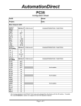
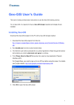
[Type text]
School Mapping User Manual
2014
For
School Education and Sport Department,
Government of Maharashtra
Designed and Developed by
Maharashtra Remote Sensing Applications Center
VNIT Campus, South Ambazari Road, Nagpur
Circulation for Official Purpose only
[Type text]
User manual for using School Mapping Application
Pre-requisities :
1)
2)
3)
4)
5)
Mobile should be Android with version 4.1 and above, Mobile should have min. 512mb of RAM.
Google map should be installed / updated on the mobile
GPS facility should be available on mobile device
Mobile should be SMS enabled.
GPRS should be enabled for the Google map.
How to install apk :
1. Get the application named “school1.apk” from the concerned officer from education
department. (Mr. Lalitkumar Bhalerao, email id - [email protected])
2. Click on school2.apk present in My Files.
3. It will install school application automatically on your device.
How to use:
1. Make sure that the GPS facility should is put “ON” before starting the application.
2. Now click on the school2
icon.
Maharashtra Remote Sensing Applications Center
VNIT Campus, South Ambazari Road, Nagpur
3. You will get the following screen for data entry.
4. Now in first step insert the school code from DISE master record.
Maharashtra Remote Sensing Applications Center
VNIT Campus, South Ambazari Road, Nagpur
5. Click on the button “School Name”. It will give you name of the school automatically.
6. Click on the “GPS” button it will give you latitude and longitude and current Date. Wait for some
time : 3-5 minutes and click on “GPS” button to get more accurate latitude and longitude values.
Don’t take readings inside a school building; prefer taking GPS location from open ground of
school or terrace of the school building. This will increase the accuracy of the GPS point.
7. Click on “Next” button . An image with the place marker is seen. The place marker is situated at
the latitude and longitude captured in the earlier screen. Check the location of the
Maharashtra Remote Sensing Applications Center
VNIT Campus, South Ambazari Road, Nagpur
placemarker.If it is correct, send sms by clicking on “sms” button. If the location is incorrect,
press “back key” of the mobile and get the gps locations again by clicking on the “GPS” button
(as done is step 7). Continue till the location is marked upto your satifaction.
8. When the location is correct, click on “SMS” button. If the sms is sent successfully the following
screen appears. Click “Ok”. If sms is not sent successfully, error message will be shown. The
error may be due to reasons such as no balance, connection failure, no google map service,
etc.
9. Outbox has all those SMS which are not sent due to some reason .Click on Refresh button it will
refresh your outbox each time.
Maharashtra Remote Sensing Applications Center
VNIT Campus, South Ambazari Road, Nagpur
10. Select which SMS you want to send by clicking on it.
Maharashtra Remote Sensing Applications Center
VNIT Campus, South Ambazari Road, Nagpur
Maharashtra Remote Sensing Applications Center
VNIT Campus, South Ambazari Road, Nagpur