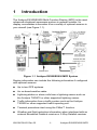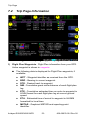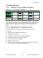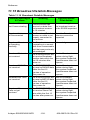
1
Multi-Function Display
Pilot’s Guide
Software Release 4 or Later
600-00078-001 Rev 05
Document History
Date
Revision
Description
10/30/08
00
Released per ECO-08-426
Supports Release 4, including TWX Cell
mode and Iridium Datalink (MLX770).
11/06/08
01
Released per ECO-08-479.
11/13/09
02
Released per ECO-09-480
12/15/09
03
Released per ECO-09-518
2/4/2011
04
Released per ECO-11-017
3/10/2011
05
Released per ECO-11-063
This document is applicable to the following part numbers:
●
Software Part Numbers 530-00193-020, Release 4 or Later, 53000201-800, and 530-00201-900
●
Hardware Part Number 700-00007-() and 700-00167-().
System Configuration
When contacting your dealer, Avidyne technical support, or logging
onto MyAvidyne.com for the first time, please have your EX500/
EX600 serial number and datalink receiver serial number available:
EX500/EX600 S/N: ____________________________________
MLB700 S/N: _________________________________________
MLX770 S/N: _________________________________________
All materials copyrighted including images that represent this software copyright
2011 Avidyne Corporation. All rights reserved. All trademarks and trade names are
the property of their respective owners. Reproduction of this publication or any
portion thereof by any means without the express written consent of Avidyne
Corporation is prohibited. For further information contact Avidyne Corporation, 55
Old Bedford Road, Lincoln, MA 01773, 781-402-7400. Information in this document
is subject to change without notice. Avidyne reserves the right to change or improve
their products and to make changes in the content of this material without obligation
to notify any person or organization of such changes or improvements.
600-00078-001 Rev 05
-i-
Avidyne EX500/EX600 MFD
About This Guide
This guide describes the Avidyne EX500/EX600 MFD with all
available sensors and software options installed. Therefore, the
EX500/EX600 page layouts and key descriptions in this guide may
differ from those on your EX500/EX600 display.
The standard EX500/EX600 version and the radar-capable EX500/
EX600 differ in the number of function knobs.
●
The standard EX500 has two knobs: a Page knob and a Range
knob.
●
The radar-capable EX500 and the EX600 have four knobs, two
on the left of the display and two on the right. The right-hand
knobs are usually used for Page and Range, the left-hand knobs
provide dedicated radar Bearing and Tilt control, along with other
functionality, depending on the page being viewed.
See Starting the EX500/EX600 on page 2 for descriptions of the
knobs and their functions. The EX500/EX600 examples shown in this
manual use the four-knob radar version.
All images contained within this document, including screenshots and
other displays, are for reference use only and are subject to change.
The images contained herein may differ slightly from your actual
equipment or display.
Notes and Warnings
Notes and Warnings provide guidance for the use of the EX500/
EX600. Avidyne strongly suggests that you read all Notes and
Warnings for your own safety.
For example:
Notes provide useful information about how to use the EX500/
EX600.
Note:
!
Warnings are prefaced with exclamation points and denote
information that can prevent serious injury or death on the part
of the user.
The instructions and warnings in this manual, however, are not
intended to replace the instructions and warnings for other equipment
Avidyne EX500/EX600 MFD
-ii-
600-00078-001 Rev 05
on your aircraft. It is critical that as the pilot in command, you have a
complete understanding of the warnings, operating instructions, and
limitations for all equipment installed on your aircraft.
!
!
This manual assumes that the reader is an appropriately
licensed pilot. Avidyne strongly recommends that you use the
EX500/EX600 only under VFR conditions until you are very
familiar with the EX500/EX600.
If you have questions, please contact Avidyne at 800-2843963 (800-AVIDYNE) or 1-781-402-7400 before operating
with the EX500/EX600 under IFR conditions.
Before conducting flight operations, be sure to verify that time
and date settings on the System Time Setup page are correct
and in GMT (UTC). It is critical that the time be set to GMT to
provide accurate display of Datalink weather. See
Chapter 9 "Aux Page for more information.
Certain GPS navigators do not support transmission of curved
flight path segments (e.g. DME arcs). These units include:
!
KLN-89B/90B/94 - Flight plan ends at entry point to arc.
Trimble 2000, 2101 - Sends multiple waypoints around arc.
Garmin 400/500 series - RS-232 displays a straight line.
Bendix/King GNS-XLS - Arc is depicted as a gap.
600-00078-001 Rev 05
-iii-
Avidyne EX500/EX600 MFD
Notice regarding NOTAM information
NOTAM information is subject to constant change, and it is
extremely important that all pilots check with Flight Service for
applicable NOTAMs prior to EVERY flight. Call 1-800WXBRIEF (992-7433) for the latest information. Outside the
United States, call your local Flight Service Station or other
official flight advisory service.
The NOTAM information provided by the EX500/EX600 is for
planning purposes only. Always consult official NOTAMS for
the latest restrictions.
Avidyne does not provide a complete list of NOTAMS. Local
NOTAMS, most laser light NOTAMS, and any NOTAMS other
than restricted airspace are not listed.
!
By using the Avidyne Services you are able to access
information made available from a variety of sources. Avidyne
does not control, edit or review the content of such information
and is not responsible for such information or the actions or
conduct of any company that provides sources of weather
data procured by Avidyne. Therefore, although Avidyne uses
diligent efforts to provide Services of high quality, ALL
SERVICES AND WEATHER DATA ARE PROVIDED AS-IS
and neither Avidyne nor its suppliers (including ORBCOMM
and its affiliates), subcontractors, information sources or
developers (collectively called “Suppliers”) are responsible for:
1) the accuracy, completeness, timeliness, reliability, content,
or availability of the Services or any information accessed; 2)
loss or damage to your records or data; or 3) your use of, or
results achieved from, the Services or any information
accessed.
Avidyne EX500/EX600 MFD
-iv-
600-00078-001 Rev 05
Contents
1 Introduction .............................................................. 1
Starting the EX500/EX600........................................................... 2
2-Knob and 4-Knob Functionality ................................................ 5
2 Map Page .................................................................. 7
Map Page Controls...................................................................... 7
Panning (EX600 Only)............................................................... 17
Map Page Symbols—Terrain and Position................................ 19
Map Page Symbols - Runways and Flight Plan ........................ 23
Errors Displayed on the Map Page............................................ 25
Loss of GPS Input ............................................................... 25
Loss of Heading Input ......................................................... 25
3 Traffic Mode and the Traffic Page (Optional) ...... 27
Traffic Advisories ....................................................................... 28
The Traffic Page ........................................................................ 29
Traffic Symbols.......................................................................... 31
TIS Sensor Status ..................................................................... 32
4 Radar Page (Optional) ........................................... 33
Map Page Overlay..................................................................... 34
Dedicated Radar Page .............................................................. 35
Dedicated Radar in Ground Mode............................................. 38
Typical Radar ............................................................................ 40
Vertical Profile Mode ................................................................. 42
Radar Warnings......................................................................... 43
5 TAWS Page (Optional)........................................... 45
TAWS Information ..................................................................... 45
TAWS Operation ....................................................................... 49
TAWS Reference....................................................................... 51
Auto-Range ......................................................................... 51
Simultaneous Alerts ............................................................ 51
Terrain Messages and Error Indications ............................. 51
6 CMax Chart Pages (Optional) ............................... 53
Chart Validity ............................................................................. 54
About Geo-Referenced Charts .................................................. 54
CMax Chart Page ...................................................................... 54
CMax Procedure Charts...................................................... 55
CMax Chart Views..................................................................... 58
Procedure Views ................................................................. 59
600-00078-001 Rev 05
-v-
Avidyne EX500/EX600 MFD
Airport Chart Views..............................................................61
Selecting an Airport....................................................................63
Selecting a Chart .................................................................65
Chart NOTAMs Page .................................................................67
European VFR Charts................................................................68
7 Trip Page ................................................................. 69
About the Trip Page ...................................................................69
Trip Page Information ................................................................70
Airport Information Page ............................................................77
8 Nearest Page (NRST) ............................................. 79
Nearest Page .............................................................................79
Airport Information Page ............................................................81
9 Aux Page ................................................................. 83
Aux Main Page...........................................................................83
Airport Filter Setup .....................................................................85
Declutter Setup ..........................................................................86
Data Block Setup .......................................................................88
System Time Setup....................................................................89
10 Datalink (Optional) ................................................. 91
Broadcast Datalink .....................................................................92
Using Broadcast Datalink in Flight.......................................92
Two-Way Datalink ......................................................................94
Flight Tracking .....................................................................95
Using 2-Way Datalink in Flight ............................................95
Loss of Satellite Coverage...................................................96
MultiLink .....................................................................................98
Overview of Datalink Weather .................................................100
Setting Up Datalink for Iridium .................................................103
Iridium Text Messaging ............................................................107
Managing Messages .........................................................108
Managing Contacts............................................................110
Composing an Iridium Text Message ................................111
Setting Up Datalink for ORBCOMM (Release 4.0 and earlier) 113
Optimizing MultiLink for ORBCOMM (Release 4.0 and earlier) .....
116
Orbcomm Text Messaging (Release 4.0 and earlier) ..............118
Composing and Sending a Message.................................121
Receiving a Message ........................................................122
11 Reference .............................................................. 123
Activating Broadcast Datalink Accounts ..................................124
Avidyne EX500/EX600 MFD
-vi-
600-00078-001 Rev 05
Completing the WSI Weather Activation ........................... 125
Activating Sirius Audio ...................................................... 126
Activating XM WX Satellite Weather ................................. 128
Activating a 2-Way Datalink Account....................................... 130
Setting Up MultiLink................................................................. 131
Cleaning the EX500/EX600 Screen ........................................ 132
Updating Your Databases ....................................................... 133
Types of Databases .......................................................... 133
About Portable USB Devices ............................................ 134
Loading NavData (the Navigation Database).................... 136
Loading CMax Chart Data................................................. 137
TAWS Display Color Coding ................................................... 140
Terrain Display Color Coding .................................................. 141
Sensor Status Block Symbols ................................................. 142
Map Symbols........................................................................... 143
Heading, Track, and Map Orientation ............................... 143
Map Symbols—Navigational Fixes ................................... 143
Map Symbols—Line Styles ............................................... 146
Data Block Information ............................................................ 148
Nav Messages......................................................................... 149
Traffic Messages ..................................................................... 150
Lightning Messages ................................................................ 151
Two-Way Datalink Messages .................................................. 154
Broadcast Datalink Messages ................................................ 156
TAWS Messages..................................................................... 159
Radar Messages ..................................................................... 161
Abbreviations and Definitions .................................................. 163
12 Using EX500/EX600 Outside the US................... 165
Features Available in the US Only........................................... 165
Features Available in North America ....................................... 165
Features Available in Other Parts of the World ....................... 166
Features Specific to International Flight .................................. 166
AVIDYNE EXCLUSIVE LIMITED WARRANTY
and LIMITATIONS ON LIABILITY.................................................. 167
Software License ........................................................................... 169
600-00078-001 Rev 05
-vii-
Avidyne EX500/EX600 MFD
List of Figures
Figure 1.1 Avidyne EX500/EX600 MFD System ................................1
Figure 1.2 Radar-Capable EX500 ......................................................3
Figure 2.1 EX500 Map Page with Radar ............................................7
Figure 2.2 METAR and AIR/SIG Keys................................................8
Figure 2.3 TWXCELL Mode Display ................................................13
Figure 2.4 Sat IR Display..................................................................15
Figure 2.5 EX600 Panning Controls and Indications ...................17
Figure 2.6 Map Page - Terrain and Position.....................................19
Figure 2.7 Map Page—Runways and Flight Plan Symbology..........23
Figure 3.1 Traffic Advisory Message ................................................28
Figure 3.2 Traffic Page .....................................................................30
Figure 4.1 Map Page with Radar Overlay ........................................34
Figure 4.2 Dedicated Radar Page ....................................................35
Figure 4.3 Dedicated Radar Page in Ground Mode .........................38
Figure 4.4 Typical Radar (Bendix/King Shown)................................40
Figure 4.5 Vertical Profile view
(Bendix/King RDS 84VP/86VP and RDR 2000/2100) ......................42
Figure 4.6 Maximum Permissible Exposure Level ...........................43
Figure 5.1 TAWS Display as shown on 4-knob EX500 ....................45
Figure 5.2 Terrain Caution Condition ...............................................49
Figure 5.3 Terrain Warning Condition ..............................................50
Figure 6.1 CMax Procedure Chart (2-Knob).....................................55
Figure 6.2 Plan Procedure Chart (4-Knob).......................................57
Figure 6.3 Procedure Chart views ....................................................60
Figure 6.4 Airport Chart Views .........................................................61
Figure 6.5 Airport Departure chart....................................................62
Figure 6.6 Airport Selection Page.....................................................63
Figure 6.7 Chart Selection Page ......................................................65
Figure 6.8 Chart NOTAMs ...............................................................67
Figure 7.1 Trip Page: Upper Display items.......................................70
Figure 7.2 Datalink Legend ..............................................................72
Figure 7.3 Trip Airport Information Page ..........................................77
Figure 8.1 Nearest Page ..................................................................79
Figure 8.2 NRST Airport Information Page.......................................81
Figure 9.1 EX500 Aux Main Page ....................................................83
Figure 9.2 EX500 Airport Filter Setup...............................................85
Figure 9.3 Declutter Setup Page ......................................................86
Figure 9.4 Data Block Edit................................................................88
Figure 9.5 System Time Edit ............................................................89
Avidyne EX500/EX600 MFD
-viii-
600-00078-001 Rev 05
Figure 10.1 Broadcast Receiver Options ......................................... 92
Figure 10.2 Two-Way Datalink......................................................... 94
Figure 10.3 Orbcomm Datalink Radar Coverage............................. 96
Figure 10.4 MultiLink........................................................................ 98
Figure 10.5 Datalink Radar Color Legend. .................................. 100
Figure 10.6 Graphical METAR Symbols ........................................ 101
Figure 10.7 Datalink Setup Page ................................................... 103
Figure 10.8 Two-Way Datalink DL tab ........................................... 107
Figure 10.9 Two-Way Datalink Option menu ................................. 107
Figure 10.10 Message Center Page .............................................. 108
Figure 10.11 Contacts Page .......................................................... 110
Figure 10.12 Compose Page ......................................................... 111
Figure 10.13 Datalink Configuration Page ..................................... 113
Figure 10.14 Coverage area for Broadcast weather ...................... 116
Figure 10.15 Datalink Messaging Page ......................................... 119
Figure 10.16 Incoming Message Alert ........................................... 122
Figure 11.1 MyAvidyne Page ......................................................... 131
600-00078-001 Rev 05
-ix-
Avidyne EX500/EX600 MFD
List of Tables
Table 1.1 2-Knob and 4-Knob Functionality .....................................5
Table 2.1 Thunderstorm Activity (Cell) Colors................................14
Table 2.2 Track Indicator Graphics ................................................20
Table 3.1 Traffic Symbols...............................................................31
Table 6.1 Procedure Chart Views...................................................59
Table 6.2 Airport Chart Views.........................................................61
Table 10.1 Message Status..........................................................109
Table 11.1 EGPWS Display Color Formats..................................140
Table 11.2 Terrain Scale Colors...................................................141
Table 11.3 Sensor Status Block Symbols ....................................142
Table 11.4 Track Indicator Graphics ............................................143
Table 11.5 Map Symbols—Navaids .............................................144
Table 11.6 Map Symbols—Airports..............................................144
Table 11.7 Map Symbols—Other .................................................145
Table 11.8 Airspace and Airways Lines .......................................146
Table 11.9 SUA and TFR Lines....................................................146
Table 11.10 AIRMET and SIGMET Boundary Lines ....................147
Table 11.11 Information from Data Block .....................................148
Table 11.12 Nav Messages..........................................................149
Table 11.13 Traffic Messages ......................................................150
Table 11.14 Lightning Messages..................................................151
Table 11.15 Two-Way Datalink Messages ...................................154
Table 11.16 Broadcast Datalink Messages ..................................156
Table 11.17 TAWS Messages......................................................159
Table 11.18 Radar Messages ......................................................161
Table 11.19 Avionics Abbreviations and Definitions.....................163
Avidyne EX500/EX600 MFD
-x-
600-00078-001 Rev 05
1
Introduction
The Avidyne EX500/EX600 Multi-Function Display (MFD) is the most
advanced situational awareness system in general aviation. Its
display consolidates information from a variety of optional sensors in
your aircraft (see Figure 1.1).
TWX670/WX-500
Lightning Sensor
Figure 1.1 Avidyne EX500/EX600 MFD System
Display information can include the following information if configured
with optional sensors:
●
Up to two GPS systems.
●
An on-board weather radar.
●
Lightning strikes or storm cells from a lightning sensor such as
the Avidyne TWX670 or other supported lightning sensor.
●
Traffic information from a traffic system such as the Avidyne
TAS600 or other supported traffic reporting unit.
●
Terminal procedure chart using the CMax™ function.
●
Weather and flight restriction information when interfaced with an
external Broadcast Datalink receiver or 2-Way Datalink receiver
600-00078-001 Rev 05
-1-
Avidyne EX500/EX600 MFD
Introduction
such as the internal Quake SC or external MLX770 two-way
datalink transceiver.
●
TAWS terrain information when interfaced with an installed
EGPWS system.
The Flight Manual Supplement (FMS) that is provided with the aircraft
contains information that is specific to your installation and might
contain operating limitations that are applicable to your aircraft
configuration. Please review it before operation.
Note:
The FAA requires that Class III aircraft with radar installations
have another independent weather indicator installed as well.
1.1
Starting the EX500/EX600
!
Before conducting flight operations, be sure to verify that time
and date settings on the System Time Setup page are correct
and in GMT (UTC). It is critical that the time be set to GMT to
provide accurate display of Datalink weather. See
Chapter 9 "Aux Page for more information.
To turn on your EX500/EX600 display, do the following:
1) Press the PWR button. After a brief initialization period, the
system will display version and database expiration information
and the message, Press Any Bezel Key. The EX500/EX600
displays the Map page in a configuration that is consistent with
the sensor set that you have installed (see Figure 1.2).
Avidyne EX500/EX600 MFD
-2-
600-00078-001 Rev 05
Starting the EX500/EX600
1
2
3
4
5
6
10
8
9
7
Figure 1.2 Radar-Capable EX500
1) BRT Button - Allows you to set the brightness level of the
EX500/EX600.
2) PWR Button - Turns the power on and off. When you turn the
power off, you need to hold the PWR button for a few seconds.
The screen displays the power-down cycle.
3) Sensor keys - Selects modes or changes the display as
indicated. A key is active when the label appears on the screen
adjacent to the key.
4) Map Function keys - Controls the basic look of the map in terms
of orientation, declutter settings, base map features, and weather
overlay.
5) Message Bar - The message bar keeps you informed about
critical as well as routine information from the EX500/EX600.
When information needs to be conveyed, the message bar
appears next to the bottom right key.
600-00078-001 Rev 05
-3-
Avidyne EX500/EX600 MFD
Introduction
Note:
The message bar displays one message at a time. If more
than one message is available, it will display the highest
priority message first. Press the ACK key to clear the current
message and view those underneath.
6) Radar Bearing Control knob (Brg) - Controls the radar bearing
selection. If you have radar-capable EX500/EX600, see Chapter
4, Radar Page (Optional), beginning on page 33, for more
information.
7) Radar Tilt Control knob - Controls the radar’s Tilt selection. If
you have radar-capable EX500/EX600, see Chapter 4, Radar
Page (Optional), beginning on page 33,” for more information.
8) Data Port - Provides a front panel access point for loading
database updates. For information on database updates, see
Chapter 11 "Updating Your Databases.
Note:When removing the rubber plug from the data port, pull the
cap gently from the right until it pops out. Make sure the
plug is all the way out before you plug anything into the
USB port.
Do not pull too hard on the tab that attaches the plug to
the EX500/EX600. This can separate the plug from the
EX500/EX600 bezel.
9) Range & Cursor Control knob - Allows you to set the Map
range. When other pages are in view, this knob provides cursor
control.
Note:
The map range choices change depending on the radar
configured The Map page and Radar page always use the
same selected range; switching between them displays the
same range.
10) Page Control knob - Provides access to the EX500/EX600’s
Map, Radar, TAWS, Chart, Trip, Nearest, Datalink, and Aux
pages. The active page is highlighted in the lower edge of screen.
Avidyne EX500/EX600 MFD
-4-
600-00078-001 Rev 05
2-Knob and 4-Knob Functionality
1.2 2-Knob and 4-Knob Functionality
Table 1.1 lists the functions of the knobs for the standard 2-knob and
the radar-capable 4-knob EX500/EX600. The versions have different
configurations to reflect different functionalities, (see Table 1.1)
.
Table 1.1
2-Knob and 4-Knob Functionality
Page
Control
Range & Cursor
Control
Radar Brg Radar Tilt
2-Knob Left
Right
N/A
N/A
4-Knob Right outer
Right inner
Left outer
Left inner
The knob controls are:
1) Page Control knob - Provides access to the EX500/EX600 Map,
Radar, TAWS, Chart, Trip, Nearest, Datalink and Aux pages. The
active page is highlighted in the lower edge of screen.
2) Range & Cursor Control knob - Allows you to set the Map
range. When other pages are in view, this knob provides cursor
control.
3) Radar Bearing Control knob (Brg) - Controls the radar bearing
selection. If you have radar-capable EX500/EX600, see Chapter
4, Radar Page (Optional), beginning on page 33 for more
information.
4) Radar Tilt Control knob - Controls the radar’s Tilt selection. If
you have radar-capable EX500/EX600, see Chapter 4, Radar
Page (Optional), beginning on page 33 for more information.
600-00078-001 Rev 05
-5-
Avidyne EX500/EX600 MFD
Introduction
THIS PAGE INTENTIONALLY LEFT BLANK.
Avidyne EX500/EX600 MFD
-6-
600-00078-001 Rev 05
2
Map Page
The Map page displays your flight plan and position as an overlay of a
map of the current flight area (see Figure 2.1). The EX500/EX600
allows you to select the data you want to display on the Map page.
The sensor keys enable you to tailor the information to meet your
flying needs. To display the Map page, rotate the Page knob to Map.
2.1
Map Page Controls
1
2
3
Figure 2.1 EX500 Map Page with Radar
Note:
For information about the Map page symbols, see Map
Symbols on page 143.
1) Sensor Functions - Controls overlay and modes of available
sensors. keys are displayed only for the sensors installed in your
aircraft:
■
Radar (if available) - Controls radar function selection.
◆
On - Starts radar operation.
600-00078-001 Rev 05
-7-
Avidyne EX500/EX600 MFD
Map Page
Note:
◆
Test - Initiates radar self-test function.
◆
Standby - Places the radar circuitry in an energized but
inactive state.
When no lightning or traffic sensors are installed, the
Lightning and Traffic keys are not displayed on the Map
page. Instead, dedicated radar keys, similar to those on the
Radar page, are displayed.
For more information about radar functions, see Chapter 4,
Radar Page (Optional), beginning on page 33.
■
Wx Rprts - Controls the type of Datalink weather information
displayed on the map.
◆
All - Displays graphical METARs, AIRMETs, and
SIGMETs.
◆
METARS - Displays graphical METARs only.
◆
AIRMET - Displays graphical AIRMETs only.
◆
SIGMET - Displays graphical SIGMETs only.
◆
DISPLY OFF - Turns off the display of weather
information from the Map page. While the display is off,
your aircraft may still be receiving weather information.
The Lightning and Traffic keys are not displayed
if radar, lightning or traffic sensors are not
installed. Instead, the METAR and AIR/SIG keys
are displayed. These keys are On\Off switches
of the respective features.
Figure 2.2 METAR and AIR/SIG Keys
Note:
For 2-way Datalink, the EX500/EX600 does not display
graphical METARs for AWOS reporting stations that are
more than 300nm from the current position or for ASOS
reporting stations that are more than 450nm from the current
position.
Avidyne EX500/EX600 MFD
-8-
600-00078-001 Rev 05
Map Page Controls
■
Lightning - Controls the display of lightning strikes or cells
(cells for WX-500 only) on the map (when interfaced with an
Avidyne TWX670, an L3 WX-500 Stormscope, or a satelliteweather Datalink receiver). For instructions on using the L3
WX-500 Stormscope, see that manufacturer’s
documentation. For TWX670 cell information, see the
WxOvly key > TWXCELL selection.
Only one mode can be displayed on the EX500/EX600 MFD
at any time. The EX500/EX600 provides scalable support for
a number of different weather sensors so you can use the
MFD to get the best view of hazardous weather and options
to avoid it.
Note:
◆
Datalink - Displays lightning strikes obtained from the
Datalink weather service, depending on the weather
service and subscription level. Lightning strikes are
represented by lightning bolts in white, yellow or dark
yellow, depending on the age of the strike.
◆
Strike - Displays lightning strikes obtained from the
lightning sensor. Lightning strikes are displayed as
follows:
◆
WX-500 lightning strikes are displayed
as yellow X’s.
◆
TWX670 lightning strikes are displayed
as X’s. Strike intensity is indicated
using 5 colors from red to green-yellow.
A strike displayed in red indicates an area of very high
intensity, while a strike displayed in green-yellow
indicates an area of low-to-moderate intensity.
When strikes are selected to display along with TWX cell
data, the strike colors change to white to improve visibility
against the colored cells.
◆
Cell - Displays storm cells using cell data obtained from a
WX-500 stormscope. Each lightning strike is displayed as
a yellow ‘+’ sign, and clumps of strikes indicate the cell
and cell intensity.
◆
Display Off - Turns display of lightning information off.
600-00078-001 Rev 05
-9-
Avidyne EX500/EX600 MFD
Map Page
■
Clear Strikes - Clears all lightning-sensor-generated
lightning strikes from the display. New lightning strikes are
more visible. Clear Strikes does not remove Datalink
lightning.
■
Traffic - Selects the altitude range of the displayed traffic
from the traffic sensor. See your traffic sensor user's manual
for details of available modes.
2) Map Functions - Controls the “look and feel” of the map,
including orientation, number of elements, and base map.
■
■
View - Changes the map orientation. Press View to cycle
between the following:
◆
Forward - 120° view with airplane’s present position
displayed at the bottom. Current heading (or track) is
displayed at the top of the map.
◆
Center - 360° view with airplane’s present position
displayed at the center of the compass range ring with
current heading (or track) at the top of map.
◆
North up - 360° view with airplane’s present position
displayed at the center, and north is always at the top of
the map.
Declutter - Controls the density of symbols and labels
displayed on the map, from highest to lowest, based on
settings defined on the Declutter Setup page. See Declutter
Setup on page 86 for additional information on customizing
the declutter settings.
➡
■
➡
➡
BaseMap - Controls the base map background. Press this
key to cycle through the following display options:
◆
Terrain -Terrain data background with water and geopolitical boundaries.
◆
Base - Black background with water and geo-political
boundaries.
◆
None - Black background. Terrain scale is removed.
Avidyne EX500/EX600 MFD
-10-
600-00078-001 Rev 05
Map Page Controls
■
Wx Ovly - Weather Overlay controls the type of weather
information displayed on the map. Press Wx Ovly to toggle
the display options:
◆
DL RDR - If installed and available, displays
2-Way Datalink RADAR information on the
map. 2-Way Datalink uses two-way
messaging to send your present position and flight plan
to the Avidyne Network Operations Center (NOC), which
then sends you only the data for your position or flight
plan, depending on your Datalink setup preferences.
◆
US RDR or CAN RDR - If Broadcast
Datalink is installed and available, the single
down arrow displays basic Datalink RADAR
information on the map. Storm cell movement is not
displayed. The external Broadcast Datalink receiver
receives a constant stream of weather data for the entire
United States via a satellite radio system. US RDR
displays CONUS weather. CAN RDR displays Canadian
weather.
◆
US RDR+ - If Broadcast Datalink is installed
and available (depending on your Datalink
service level), the single down arrow and
plus sign displays full Datalink RADAR for CONUS,
including storm cells.
For many operations, the EX500 displays weather data in
the same way, regardless of which Datalink system is in
use. Both systems provide datalink radar data—a
composite image depicting precipitation as seen by
multiple ground-based weather radar sites. The image is
color-coded to show intensity levels and precipitation
types. Broadcast Datalink, however, especially at a
600-00078-001 Rev 05
-11-
Avidyne EX500/EX600 MFD
Map Page
higher service level, provides more data (such as storm
cell movement and Datalink lightning).
For Datalink RADAR, small areas of high-intensity datalink
radar data might not be displayed on the EX500/EX600 at
high range settings. Instead, larger areas of surrounding
lower-intensity returns might obstruct indications of severe
precipitation at Map ranges higher than 250 nm. Avoid using
Map ranges greater than 250 nm when RADAR echoes are
shown in the vicinity of the aircraft.
!
◆
TWXCELL - If Wx Ovly is set to TWXCELL,
the EX500/EX600 displays thunderstorm
cells detected by the TWX670, using colors
(Table 2.1) to indicate levels of storm intensity. For
example, Figure 2.3 shows an aircraft located at the edge
of intense thunderstorm activity. In this instance, the
aircraft must be flown away from the thunderstorm. The
TWX670 detects and measures lightning strike energy
and generates cell data that the EX500/EX600 displays
Avidyne EX500/EX600 MFD
-12-
600-00078-001 Rev 05
Map Page Controls
in color. This mode shows dangerous convective areas
that you must avoid.
Figure 2.3 TWXCELL Mode Display
Note: In Release 4, if cells appear in the same location as navaids,
obstacles, or TFRs, the cells will cover part or all of the navaids, obstacles,
or TFRs. To more clearly view the navaids, obstacles, or TFRs, turn off the
TWXCELL mode by pressing WxOvly and selecting DSPLY OFF or one of
the other options. When desired, you can switch back to CELLMODE to see
the storm cells.
In Release 4.1 and later, cells are located underneath navaids, obstacles,
and TFRs.
The TWX670 sensor outputs hexagons of varying widths
from 0.5 NM to 10.0 NM. Occasionally, as the MFD
display is zoomed, you may notice that the hexagon size
changes abruptly. This is normal as the MFD consistently
uses the highest fidelity TWX lightning data available.
Note:
(EX600 Only) When panning with TWXCELL mode
displayed, cells further than the current range setting,
centered on the the aircraft present position, will not be
displayed. To see all cells when panning, select 200 nm
range or greater.
600-00078-001 Rev 05
-13-
Avidyne EX500/EX600 MFD
Map Page
Table 2.1 describes the colors displayed by the EX500/
EX600.
Table 2.1Thunderstorm Activity (Cell) Colors
Color
Interpretation
Red
Intense thunderstorm activity - presence of
hazardous atmospheric conditions is certain.
Orange
Weather conditions are approaching intense
thunderstorm activity.
OrangeYellow
Heavy thunderstorm activity - high likelihood of
hazardous atmospheric conditions.
Yellow
Weather conditions are approaching heavy
thunderstorm activity.
GreenYellow
Moderate thunderstorm activity - severe turbulence
and unsettled atmospheric conditions likely.
Green
Weather conditions are approaching moderate
thunderstorm activity and moderate turbulence is
likely.
BlueGreen
Light thunderstorm activity - atmospheric instability
and moderate turbulence is likely (Release 4 only,
Blue-Green color is not used in Release 4.1 and
later).
Color representing less intense thunderstorms does not imply
that it is acceptable or safe to fly in those areas. Always
avoid areas of indicated thunderstorm activity,
regardless of color displayed.
!
The TWX670 detects thunderstorm cell activity up to a
200 nm range. The range control on the EX500/EX600
enables you to zoom in or out to see the distribution of
convective activity.
If both datalink weather and TWX670 are installed in the
aircraft, you can use both to determine the best course of
action to avoid dangerous weather.
◆
RADAR - Displays on-board weather radar returns on
the map. This choice does not appear if the EX500/
EX600 is not configured with an aircraft heading source,
or if aircraft heading is currently unavailable.
Avidyne EX500/EX600 MFD
-14-
600-00078-001 Rev 05
Map Page Controls
◆
Sat IR - If installed and available, displays
2-Way Datalink Infrared Satellite cloud
information on the map, using shades of
gray. The SatIR depiction uses a series of grayscale
values to represent cloud tops of different temperatures,
ranging from approximately 0 deg C (dark gray) to -110
deg C (white). Colder cloud tops are generally higher
than warmer clouds. Occasionally, warm clouds may
not be visible on the display. Additionally, very cold
terrain may be displayed as clouds when no clouds
actually exist.
The Sat IR images are delivered with variable resolution
of between approximately 10 km near the ownship to 30
km 100+ nm along the flight path. The EX500/EX600
smooths the edges of the SatIR images so that the
images are not distracting at smaller zoom ranges. Like
DL RDR, the 2-way Datalink Sat IR uses two-way
messaging to send your present position and flight plan
to the Avidyne Network Operations Center (NOC), which
then sends you only the Sat IR data for your position or
flight plan, depending on your Datalink Setup
preferences.
Figure 2.4 Sat IR Display
◆
DSPLY OFF - Removes all onboard and datalink radar
data from the map display.
600-00078-001 Rev 05
-15-
Avidyne EX500/EX600 MFD
Map Page
Note:
Diagonal stripes indicate the boundary of available datalink
radar or SatIR data. If datalink radar or SatIR is unavailable in
a particular area, hatched lines appear in that area.
3) The ACK is used to display and acknowledge system messages.
Avidyne EX500/EX600 MFD
-16-
600-00078-001 Rev 05
Panning (EX600 Only)
2.2 Panning (EX600 Only)
The EX600 includes the ability to pan the map. This allows the map
to be panned to areas of interest that otherwise would not be visible
at a given range. This is especially useful for viewing the current
datalink weather along your route of flight and at your destination. On
the EX600, there are 5 keys that allow panning on the map.
3
5
4
6
2
1
Figure 2.5 EX600 Panning Controls and Indications
1) Direction keys - Pan the map in on of four directions on the
screen: left, right, up, and down.
2) QuickPanTM key ■
If in panning mode, press to center the map on the own-ship
symbol and exit panning mode.
■
If not in panning mode, press to enter panning mode and
center the map on the last panned location.
600-00078-001 Rev 05
-17-
Avidyne EX500/EX600 MFD
Map Page
Note:
For best results, press and hold down the appropriate
direction key until the map is panned to the desired location,
then release.
3) Range indication - Panning circle radius in nautical miles (NM)
for determining the map scale.
4) Distance - Distance from the ownship in nautical miles (NM).
5) Ownship Direction - Arrow points in the direction to the current
ownship location.
6) Panning mode indication - Displays when in panning mode.
Also indicates the time remaining in seconds before panning
mode will time-out.
Panning will time-out after 20 seconds from the last button push or
range change. At that point panning mode will exit and the map will
center on the own-ship position.
The map range can be adjusted while in panning mode to allow
greater flexibility in viewing information of interest.
Note:
Panning is limited to 75° S to 75° N latitudes. The panning
cursor will not pan across the 180° longitude meridian.
Note:
When panning with TWXCELL mode displayed, cells further
than the current range setting, centered on the the aircraft
present position, will not be displayed. To see all cells when
panning, select 200 nm range or greater.
Avidyne EX500/EX600 MFD
-18-
600-00078-001 Rev 05
Map Page Symbols—Terrain and Position
2.3 Map Page Symbols—Terrain and Position
The EX500/EX600 Map page uses included and optional sensors to
depict the position of your aircraft in relation to the following: your
flight plan, nearby airports, terrain, traffic, lightning, special use
airspace and other navaids (see Figure 2.3).
Note:
For detailed information about each Map page symbol, see
Map Symbols on page 143.
23
1
3
7
4
6
5
9
8
Figure 2.6 Map Page - Terrain and Position
1) Sensor Status Box - Displays the status of the available sensors
including radar, traffic, lightning, and Datalink.
The onboard radar display includes the mode and tilt angle. The
traffic display shows the mode and range. For lightning, the
source is displayed.
The datalink radar or Sat IR display includes the data age, which
is the elapsed time since the last product was created by the
weather provider.
600-00078-001 Rev 05
-19-
Avidyne EX500/EX600 MFD
Map Page
2) Heading/Track Block - The Heading/Track (H/T) Block provides
a digital readout of the current heading, or actual track. Map
orientation is indicated in the triangle to the right of the H/T Block.
Table 2.2
Track Indicator Graphics
Heading
Track
Map Orientation
Heading
Desired
Track
North Up
Track
Heading
Heading Up
Actual Track
Track Up
3) Data Block - Displays pilot-selected navigation data in the upper
right corner of the screen. See Data Block Setup on page 88 for
details on how to configure this display.
4) Heading/Track Indicator - Three triangles around the compass
range ring provide actual track, desired track, and heading
indications.
5) Lightning and Storm Cell Indications - Displays geographically
referenced lightning strikes (if configured). Strikes are
represented by a yellow “X” in Strike Mode and by a yellow “+” in
Cell Mode (WX-500 only). Strikes from a Datalink system are
represented by a lightning bolt symbol in one of three different
colors, depending on the age of the strike.
If you have Broadcast Datalink, and depending on
your level of service, storm cells will show speed and
direction of movement. The underlined number
indicates the tops of the storm cells, in hundreds of
feet. The storm cell indicators are black for rain (or
snow) and white to show probability of hail. In the
example, the bottom storm cell, which includes the probability of
hail, is moving NNE at 33 knots. The cell top is 35,000 feet high.
Avidyne EX500/EX600 MFD
-20-
600-00078-001 Rev 05
Map Page Symbols—Terrain and Position
At longer range settings, individual lightning strikes and storm
cells are combined into single strikes or single storm cells,
depending on their proximity. This avoids clutter and
improves readability. And vice versa, lower map range
settings will display more strikes and storm cells.
Note:
6) Compass/Range Ring - Displays a 360-degree compass range
ring or a 120-degree compass arc with current range setting. The
range number is the distance from the graphic aircraft symbol to
the outer compass range ring.
7) Special Use Airspace -The EX500/EX600 uses several different
line styles to convey special use and class airspaces. Class B,
Class C, Class D, MOA, SFRA, Warning, and Alert areas,
restricted and prohibited areas are displayed. See Map
Symbols—Line Styles on page 146 for more information.
!
Do not rely on the EX500/EX600 as your sole source for
SUAs. The status of SUAs may change or may be
unavailable. Before conducting a flight, always confirm the
state of SUAs with FAA Flight Service.
8) Datalink Radar Status Box (EX500 only) - If more than three
sensors are installed on the EX500, data for the datalink radar
status is displayed at the bottom of the page instead of in the
Sensor Status Box. DL RDR indicates MLX770 Iridium datalink
radar data status, NXR for ORBCOMM datalink radar data status,
US Rdr for US Broadcast datalink radar status, and CAN Rdr for
Canadian Broadcast datalink radar status.
!
When using Datalink weather, monitor the data age so that
you are aware of the time elapsed since the last weather
update.
9) Terrain Scale - Legend colors represent terrain elevations. The
left number on the scale shows the lowest terrain currently
displayed on the map, and the right number shows the highest
terrain on the map. The terrain scale also displays obstacle
height if the highest obstacle exceeds the highest terrain. A small
cyan window will be displayed when this occurs.
600-00078-001 Rev 05
-21-
Avidyne EX500/EX600 MFD
Map Page
Note:
Terrain data is not displayed when that latitude of your
aircraft is greater than 75 degrees (north or south).
Note:
Terrain data may not be displayed while you are near the 180
degree meridian (while the meridian is within the displayed
map area).
Terrain legend colors are shown in Terrain Display Color Coding
on page 141.
!
The displayed terrain and obstacle indicators are only
advisory. It is dangerous to rely on the EX500/EX600 as the
sole source of obstacle and terrain avoidance information.
Always refer to current aeronautical charts for appropriate
terrain and obstacle information.
!
The EX500/EX600 Map Terrain display is not a substitute for
a TAWS display and does not provide any type of terrain alert
function. The map terrain displayed on the EX500/EX600 is
presented as the height above mean sea level (MSL) and
does not indicate the height of the aircraft above the terrain.
Avidyne EX500/EX600 MFD
-22-
600-00078-001 Rev 05
Map Page Symbols - Runways and Flight Plan
2.4 Map Page Symbols - Runways and Flight
Plan
When you look at the Map page at lower ranges, you can see details,
such as runway diagrams that are not available at longer ranges (see
Figure 2.4).
1
5
2
3
4
Figure 2.7 Map Page—Runways and Flight Plan Symbology
1) Airport Runway Diagrams - When the Map page is set to under
20NM, the EX500/EX600 displays runway layouts of the
destination airport and nearby airports.
2) Flight Plan - Displays the active flight plan from the selected
GPS on the map. The current leg is displayed in magenta and all
other legs are shown in white. When an approach procedure is
selected on a GPS that supports the GAMA graphics interface,
the EX500/EX600 shows all approach segments including the
following: holds, DME arcs, and procedure turns.
3) Ownship Symbol - Shows the position of your aircraft in relation
to the moving map and the selected view.
4) Traffic Indications - Displays traffic symbols relative to the
present position of the aircraft and includes relative altitude
(when available) with respect to aircraft. See the Traffic Sensor
User’s Manual for further details.
600-00078-001 Rev 05
-23-
Avidyne EX500/EX600 MFD
Map Page
5) Obstacles - The EX500/EX600’s U.S. database contains the
location and height of towers and other obstacles that are greater
than 200 feet AGL. All obstacles are depicted in height above
mean sea level (MSL).
A 2000 foot tall TV tower located in Denver (elevation 5300 feet
MSL) will be depicted as being at 7300 feet MSL.
Note:
The EX500/EX600 obstacle database only contains U.S.
obstacles. Not all obstacles are displayed in the database
(due to new construction, temporary structures, etc.). Consult
your charts and NOTAMS as required by the FARs
!
The Map page Terrain Display is neither certified as nor
intended to be a primary Terrain Awareness system. The
displayed terrain and obstacle indicators are only advisory. Do
not rely on the EX500/EX600 as the sole source of obstacle
and terrain avoidance information. Always refer to current
aeronautical charts for appropriate terrain and obstacle
information.
You can also use the Nearest (NRST) function to determine the
specific information relative to the obstacles around you. Obstacles
are sorted by distance from your aircraft. The altitude of the obstacle
is also displayed.
Additional terrain awareness and alerting capability is available for
the EX500/EX600 when interfaced with a Terrain Awareness and
Warning System (TAWS). For more information, see Chapter 5,
TAWS Page (Optional), beginning on page 45.
Avidyne EX500/EX600 MFD
-24-
600-00078-001 Rev 05
Errors Displayed on the Map Page
2.5 Errors Displayed on the Map Page
2.5.1
Loss of GPS Input
The loss of primary GPS on the EX500/EX600 is shown as follows:
1) The aircraft symbol is removed.
2) There is no heading information displayed (if GPS has been
selected as your heading source/track).
3) The desired track icon is removed from the compass range ring.
4) There is no groundspeed information displayed.
The EX500/EX600 will continue to provide Datalink weather for your
flight based on the last known GPS track and groundspeed. If the
primary GPS fails during the flight, and you have a second GPS
connected to the EX500, you can switch your GPS input to the
backup source by pressing the Nav Src key on the Aux page.
2.5.2
Loss of Heading Input
The source of heading data on your aircraft depends on the other
sensors you have installed in your aircraft. Loss of heading is typically
associated with the failure of one of the following:
1) The WX-500 Stormscope system (if installed and a heading
source is connected to the WX-500).
2) The Skywatch system (if installed and a heading source is
connected to the TAS).
3) A separate heading Synchro (if installed).
4) An Avidyne PFD.
5) The GPS (This would be a pass through. The GPS does not
determine heading).
Loss of heading will be shown in the following ways:
●
The heading indicator will be blank.
●
A “Heading source invalid” message will be displayed.
●
The aircraft symbol will change to a plus (“+”) sign (nondirectional).
●
The map display orientation will change to North-up.
●
The heading block value will be dashed (“- - -”).
600-00078-001 Rev 05
-25-
Avidyne EX500/EX600 MFD
Map Page
THIS PAGE INTENTIONALLY LEFT BLANK.
Avidyne EX500/EX600 MFD
-26-
600-00078-001 Rev 05
3
Traffic Mode and the Traffic
Page (Optional)
When a Traffic Advisory (TA) is reported from the traffic sensor, the
EX500/EX600 displays a traffic alert message in the Message Bar.
To acknowledge the traffic alert, press the ACK key next to the
message. This displays the dedicated traffic page to provide you with
maximum traffic situational awareness.
!
It is dangerous to rely on the EX500/EX600 as your sole
source of data for collision avoidance. Traffic
information is provided as an aid to your visual
determination of traffic. Maneuver your aircraft based
only on ATC guidance or positive acquisition of
conflicting traffic. It is your duty as pilot in command to
see the possible danger and avoid collisions.
Notes: The intruder track information provided by TIS traffic systems
is only accurate to within 45° of true intruder track. Take this
into account when visually determining the reported traffic.
Keep in mind that intruder traffic can maneuver at any time,
and the current intruder track direction does not guarantee
that the intruder will continue along that track.
For traffic sensors without track information (e.g. TAS), traffic
symbols are shown without the “stinger”.
600-00078-001 Rev 05
-27-
Avidyne EX500/EX600 MFD
Traffic Mode and the Traffic Page (Optional)
3.1
Traffic Advisories
2
3
1
Figure 3.1 Traffic Advisory Message
If your aircraft is equipped with a traffic system such as TAS, TIS,
TCAS, or TCAD, you can see traffic overlaid on the moving map.
1) Traffic key - Basic traffic system control is performed through the
Traffic key on the Map page. Target aircraft are displayed in
standard format relative to current aircraft position. The available
Traffic key modes are:
■
Avidyne TAS600 series (including 9900BX), Skywatch,
and Bendix/King, TCAS - ABOVE, NORMAL, UNLIMTD,
BELOW, and DSPLY OFF.
■
TCAD 9900B - GROUND, TERMINAL, STANDARD,
ENROUTE, UNLIMITD, APPROACH, and DSPLY OFF.
Note:
Some TCAD installations will support automatic modeswitching by the TCAD unit. The current mode is always
reported on the EX500 screen.
■
TIS - DSPLY ON and DSPLY OFF.
For more information on specific traffic sensor modes, consult the
user documentation for your traffic sensor.
Avidyne EX500/EX600 MFD
-28-
600-00078-001 Rev 05
The Traffic Page
2) View key - Use View to control the orientation of the map and
sensor data displayed on the EX500/EX600. EX500/EX600 traffic
and weather symbols are positioned relative to the aircraft
symbol nose.
3) Traffic Advisory - When a Traffic Advisory (TA) is reported from
the traffic sensor, the traffic symbol of the threat aircraft turns
yellow, and the EX500/EX600 displays a traffic alert message in
the message bar (see Figure 3.1) to help focus your attention
where it is needed.
When you acknowledge this message, the EX500/EX600
displays a dedicated Traffic page (see Figure 3.2) to allow you to
identify the threat and take appropriate action. The TA message
is removed automatically when the threat is reduced or the target
aircraft is no longer present.
3.2 The Traffic Page
The Traffic page is a specially configured Map page that is displayed
only when you acknowledge (by pressing ACK) a Traffic Alert (TA)
message. This page displays the following:
●
View - With either Center View or North up View selected on the
Map page, acknowledging a traffic alert opens a dedicated traffic
page with a complete circular range ring. With Forward View
selected on the Map page, acknowledging a traffic alert opens a
dedicated traffic page with an Arc range ring.
●
Range - 5 NM
●
Base Map - No terrain or political boundaries
●
Declutter - No symbol or airspace depictions
●
Lightning - Not displayed
●
Flight Plan - Displayed
●
Datalink Weather - Not displayed
●
Wx Reports - Not displayed
The EX500/EX600 displays up to five (5) non-bearing intruders below
the airplane symbol, that is, traffic threats reported by the traffic
sensor but without valid bearing. This serves as an alert that there is
traffic, but its exact location cannot be determined.
600-00078-001 Rev 05
-29-
Avidyne EX500/EX600 MFD
Traffic Mode and the Traffic Page (Optional)
1
2
Figure 3.2 Traffic Page
1) Exit Traffic - Takes you to the regular Map page. Keep in mind
the following:
■
Pressing Exit Traffic always takes you to the Map page.
■
If you press Exit Traffic while the intruder is still in range, the
TA message will remain on the Map page. Acknowledging it
will re-display the Traffic page.
Note:
Traffic limitations and operational ranges depend on the
installed traffic sensor. For TAS or TCAD sensors, see the
corresponding sensor Pilot Guide. For TIS sensors, see the
Aeronautical Information Manual.
2) Range Control - Turn the Range knob to select from the
available ranges.
Note:
For Traffic messages, see Traffic Messages on page 150.
Avidyne EX500/EX600 MFD
-30-
600-00078-001 Rev 05
Traffic Symbols
3.3 Traffic Symbols
Aircraft that are detected by a Traffic Sensor are referred to as
intruders and are displayed as one of three symbols (see Table 3.1).
If a compatible TIS system is installed and intruder track information
is available, the appropriate symbol will be shown with a “stinger”,
which depicts the current ground track of the intruder, as detected by
ATC radar.
Table 3.1
Traffic Symbols
Symbol
Type
Traffic Alert (TA)
(with intruder track)
Meaning
Traffic that is within the alert zone
defined by the traffic sensor.
Proximate Traffic
Traffic that is not within an alert zone
(without intruder track) but is close to your position.
Other Traffic
(with intruder track)
!
Traffic that is detected by the traffic
sensor, but determined not to be a
current threat.
Traffic sensors do not provide any traffic awareness data for
aircraft without operating transponders. Therefore, these
aircraft will not be displayed on the EX500/EX600. It is your
responsibility to see and avoid all other traffic and to maintain
appropriate separation.
1
2
3
Traffic alert information is displayed in the message bar (shown
above). The traffic alert display contains the following information:
1) Relative bearing of target.
2) Range in nautical miles.
3) Relative altitude, for example, -200 would be 200 feet below.
If the intruder altitude and vertical speed are known, they are
displayed alongside the intruder symbol. The number immediately
above or below the traffic symbol indicates the relative altitude of the
600-00078-001 Rev 05
-31-
Avidyne EX500/EX600 MFD
Traffic Mode and the Traffic Page (Optional)
intruder to your position, in hundreds of feet. An arrow next to an
intruder symbol shows the direction of any vertical movement of the
intruder that is in excess of 400 feet per minute.
3.4
TIS Sensor Status
The following may be reported in the Traffic status block on the Map
page:
●
OPER - The TIS sensor is operating normally.
●
CST 00:00 - The TIS sensor has temporarily lost the information
feed from ground-based radar and is in “coast” mode. The MFD
will continue to display the traffic last received, while the CST
timer will count the seconds since the last valid data.
●
RMV 00:00 - After 12 seconds of coasting, the TIS sensor will
remove the traffic display and display RMV, and continue to count
the time since the last valid data.
●
UNAVAIL - More than 60 seconds have passed since valid data
was received, or TIS data is not available at the current aircraft
location.
●
SBY - The TIS sensor is in standby mode.
●
DATA FAIL - The TIS sensor has reported an internal fault.
Traffic information is removed from display.
Avidyne EX500/EX600 MFD
-32-
600-00078-001 Rev 05
4
Radar Page (Optional)
The radar-capable EX500/EX600 is designed to replace an existing
radar indicator. Its user interface is more intuitive, and it is integrated
with other sensors such as traffic and lightning (if installed).
For convenience, the radar control functions used most frequently are
on the left side of the Map page. This placement enables you to use
your map functions continuously and even overlay weather radar data
on your base map.
To view the largest amount of situational data, use the Map page with
your radar. You can use the dedicated Radar page to provide
occasional radar-only display and/or detailed radar control.
Turn the right outer knob to display the Radar page. This page
provides a traditional (non-overlaid) radar display as well as
comprehensive control of the radar as well as access to the complete
list of features.
Actual operation of the radar function depends on the
particular make and model of the installed radar. Make sure
you are familiar with the functionality and operation of the
radar system installed on your aircraft. See the user's guide
for your radar for details.
Note:
!
Radar is intended as a severe weather avoidance tool only.
Do not use the EX500/EX600 to penetrate severe weather,
thunderstorms, cells or lines of cells.
600-00078-001 Rev 05
-33-
Avidyne EX500/EX600 MFD
Radar Page (Optional)
4.1
Map Page Overlay
1
Figure 4.1 Map Page with Radar Overlay
1) Radar key - Press the Radar key to turn on the radar. The
current tilt (up or down) will be displayed in the sensor status box.
Use the left knob to change the bearing (outer knob) and tilt
(inner knob) of the radar. The left outer knob can be configured to
control Gain when in Ground/Search Mode (Bendix) or all of the
time (Collins).
As part of your pre-takeoff check, check for proper operation of your
installed radar. While at a safe distance from ground personnel and
other aircraft, briefly turn the radar ON and tilt the antenna below zero
degrees. If the radar is working properly this will produce ground
reflections and verify the correct operation of the transmitter/receiver
and antenna tilt functions.
After landing, set the radar to Standby. A warning message is
displayed if the radar is not OFF or in standby and your groundspeed
(as received from the GPS system) falls below 20 Kts. If Auto
Standby is enabled, the EX500/EX600 switches the radar to Standby
automatically when ground speed falls below 20 Kts.
Avidyne EX500/EX600 MFD
-34-
600-00078-001 Rev 05
Dedicated Radar Page
When Traffic and Lightning sensors are installed, only
the main Radar key is available on the Map page.
However, if fewer external sensors are installed, the
EX500/EX600 takes advantage of the available keys.
For example, if a second key is available for radar
functions, a dedicated Radar Off key is displayed.
Similarly, if other keys become free, additional radar
keys display, including Radar Test and Radar Standby.
Note:For radar messages, see Radar Messages on
page 161.
4.2
Dedicated Radar Page
If your EX500/EX600 is radar-equipped, select Radar from the Page
Bar to display the Radar page.
1
3
4
2
5
6
7
8
9
10
Figure 4.2 Dedicated Radar Page
1) Tilt Indicator - Indicates the tilt angle and direction of the radar
antenna: U for up, D for down with the amount of antenna tilt in
quarter degrees using decimal notation.
600-00078-001 Rev 05
-35-
Avidyne EX500/EX600 MFD
Radar Page (Optional)
2) Precipitation Echoes - Precipitation returns from the R/T are
displayed as color coded echoes. Refer to Appendix G for color
meanings.
3) Scan Indicator (BeamView™) - The current position of the scan
is shown by a gray radial arc, representing the width of the radar
beam.
4) Range - Indicates the current range scale (the outer ring). In this
case, the current range is 80 nautical miles.
5) Stabilization Status (not shown) - Indicates the status of the
radar's gyro stabilization. When stabilization is turned OFF, a
STAB OFF screen annunciation appears.
6) Function Annunciation - The function annunciation (On, Test,
Standby, Off) indicates the function status.
7) Beam Altitude (TiltView™) - The Beam Altitude numbers
display the relative altitude (in thousands of feet) of the center of
the radar beam compared to the aircraft's altitude at the distance
shown above each number.
8) Bearing & Gain Control (Brg/Gain) - The left outer knob
controls either the bearing line or the radar gain, depending on
the state of the Knob key.
■
Brg - When selected with the Knob key, the bearing line is
controlled in increments of 1°. The relative bearing is
displayed at the top of the screen: L for left, R for right, with
the number of degrees relative to the aircraft heading.
■
Gain - When selected with the Knob key, the left outer knob
controls the radar’s gain setting.
9) Tilt Control - The left inner knob controls the antenna tilt. Each
click of the knob changes the tilt by 0.25°. Turning the knob to the
right tilts the antenna up, to the left tilts the antenna down. Tilt
angle is displayed in the upper left corner of the display screen.
Tilt values are in degrees and range from D 15.00° (DOWN) to U
15.00° (UP).
Range - The right inner knob controls the range scale. Turn the
knob clockwise to increase the range scale and counterclockwise to decrease the scale.
Avidyne EX500/EX600 MFD
-36-
600-00078-001 Rev 05
Dedicated Radar Page
10) The range scale includes the following ranges:
■
Collins - 10, 25, 50, 100, and 250nm.
■
Bendix/King - 5*, 10, 20, 40, 80, 160, 240, and 320nm,
depending on radar/Type.
Based on recommendations made by the FAA and the radar
manufacturer, Avidyne recommends the following safety
procedures:
• At startup, if the radar is not being used in flight, ensure
that it is turned off.
!
• Upon landing, if the radar is being used during the flight,
switch to standby as soon as possible.
• Set the radar to test whenever it is convenient to do so in
pre-takeoff checks. No microwave radiation is emitted in
test operation. Never turn the radar on without first
checking its operation in test mode.
• Never turn the radar on while on the ramp under any
circumstances.
600-00078-001 Rev 05
-37-
Avidyne EX500/EX600 MFD
Radar Page (Optional)
4.3
Dedicated Radar in Ground Mode
1
6
2
7
3
8
4
9
5
Figure 4.3 Dedicated Radar Page in Ground Mode
1) Radar ON - Turns the radar on in normal operation. If the radar is
on, the mode annunciator is set to ON, and the moving scan
indicator, radar echoes are visible.
2) Radar Test - Initiates a radar self-test function that is monitored
by the EX500/EX600. The test function is confirmed by the
presence of the test annunciation and the test pattern display.
During self test, all of the circuitry and functions of the R/T are
exercised with the exception of the magnetron tube. No
microwave energy is emitted in the test function. The display will
have a test pattern with the following colors: green, yellow, red
and magenta.
3) Radar Standby - Places the radar circuitry in an energized but
inactive state. Select Standby as soon as it is practical to do so
after starting the EX500/EX600. When the radar is in standby, the
mode annunciator is set to STBY, and the moving scan indicator
and radar echo returns are not present. Standby mode also
places the antenna in the desired park position.
4) Radar Off - Removes power from the radar. The antenna does
not scan and no microwave energy is emitted. When the radar is
off, the mode annunciator is set to OFF, and the moving scan
indicator and radar echo returns are not present.
Avidyne EX500/EX600 MFD
-38-
600-00078-001 Rev 05
Dedicated Radar in Ground Mode
5) Knob - Toggles the left outer knob function from “Bearing” to
“Gain” to allow you to adjust the Gain setting. The Knob settings
depend on the radar type as follows:
■
Collins - Knob is only available if the Control key (9) is set to
MODE.
■
Bendix/King - Knob is only available if the Control key (9) is
set to MODE and the Mode key (6) is set to GND (or SRCH
for RT1301/RT1401).
6) Mode - There are three radar Modes:
■
WX - Normal weather mode used during flight. At startup the
WX mode is preselected.
■
WXA (Bendix)/CYC (Collins) - The weather alert mode
(Cyclic Contouring) operates the same as the Wx mode
except the red areas (indicating severe conditions) flash
between red and black as a further visual cue of hazardous
conditions.
■
GND (Bendix)/MAP (Collins)/SRCH (RT1301/RT1401) Ground map mode orients the radar to the ground features.
While in ground map mode, the radar's receiver gain may be
adjusted using the left outer knob. At startup, the gain is set
for maximum.
7) Scan - On supporting antennas, Scan allows the selection of
either Normal or Sector Scan. Sector Scan reduces scanning
azimuth.
8) VP - (Bendix/King RDS84VP/86VP and RDR2000/2100 radar
only) Places the radar in Vertical Profile operation, described in
Vertical Profile Mode on page 42. Confirmation that the radar is
on is indicated by the presence of the moving scan indicator,
radar echoes, and the on screen annunciation.
9) Control - Switches the bottom left key and top right three key
functions to control the Settings as described in Typical Radar on
page 40. Push Control again to bring the top right three key
functions back to “Mode” as described above.
600-00078-001 Rev 05
-39-
Avidyne EX500/EX600 MFD
Radar Page (Optional)
4.4
Typical Radar
2
3
4
1
Figure 4.4 Typical Radar (Bendix/King Shown)
1) ARL (Automatic Range Limit) - (Bendix/King RDR-2100 and
RDS86/VP only) Automatic range limit (ARL) depicts the limit of
your radar range. ARL calculates the attenuation of the
microwave signal based on an integration of the returned echoes
along the radial path. The R/T draws BLUE from that calculated
point to the edge of the covered range. When ARL is selected, an
on-screen annunciation is displayed to indicate that it is active.
2) Target - Turns the Target Alert mode on or off. A target alert
appears when the radar detects heavy echoes ahead that might
not be appear within the displayed range of the Radar. Target
Alert works as follows:
■
Collins - Target Alert consists of two screen indications.
When Target Alert is ON but not active, the alert is displayed
as, “TGT”, in white text in the upper right corner of the screen.
When the alert becomes active, it turns yellow and is
surrounded by a yellow box.
The second indication is a Message warning when viewing
another page (Map, for example). The Message text is,
“Heavy Radar Echoes Beyond 60nm”. The Message warning
is cancelled when you acknowledge it (by pressing the ACK
key), or when the alert is eliminated by the radar sensor.
Avidyne EX500/EX600 MFD
-40-
600-00078-001 Rev 05
Typical Radar
■
Bendix/King - A Target Alert consists of two screen
indications. When echoes are detected beyond 80nm, two
red arcs will appear on the dedicated Radar page at the top
of the screen. The second indication is a Message warning
when viewing another page (Map, for example). The
message text is, “Heavy Radar Echos Beyond 80nm”, and is
cancelled when you acknowledge it (by pressing the ACK
key), or when the alert is eliminated by the radar sensor.
3) Auto Tilt - Press the AUTO TILT key to select manual or
automatic radar antenna tilt control. When in AUTO TILT, the
antenna position will be adjusted automatically to maintain a
common beam intercept point with the earth. For example, if the
last 10% of the display is ground returns, then during ascent or
descent the antenna tilt will be changed automatically to maintain
ground returns on 10% of the display. Ranging in and out will also
maintain a common beam interception point up to the physical
limit of the antenna.
4) Stab (Stabilization) - Turns the radar sensor gyro stabilization
ON or OFF. An on-screen annunciation (STAB OFF) is displayed
in the upper right hand corner when stabilization is turned OFF.
600-00078-001 Rev 05
-41-
Avidyne EX500/EX600 MFD
Radar Page (Optional)
4.5
Vertical Profile Mode
VP (Vertical Profile) - The vertical profile mode allows you to view
approaching weather as a slice of the vertical plane instead of the
conventional horizontal, forward view.
The vertical profile display contains the same functions and modes
shown on the horizontal display. However, they may be in another
location due to the different configuration. A vertical profile
annunciation (PROFILE) provides the current azimuth displayed on
the screen, in degrees left (L), right (R) or centered.
Figure 4.5 Vertical Profile view
(Bendix/King RDS 84VP/86VP and RDR 2000/2100)
Avidyne EX500/EX600 MFD
-42-
600-00078-001 Rev 05
Radar Warnings
4.6
Radar Warnings
Aircraft weather radar is specifically designed to emit a
concentrated beam of microwave energy at potentially hazardous
power levels. These hazards include the possibility of injury to
ground personnel, ignition of flammable materials, including fuel,
and damage to sensitive electronic devices. The pilot in command
is responsible for management of the radar system.
The FAA has published an Advisory Circular, AC 20-68B,
Recommended Radiation Safety Precautions for Airborne Weather
Radar, with basic guidelines for safe radar operation.
!
U.S. Government standards for human exposure to microwave
radiation permit a maximum level of 10 mW per square centimeter.
When the radar is operating, this level may be exceeded within the
area indicated in the figure below. According to information
published by the radar manufacturer, strict observance of this
boundary whenever the radar is operating should provide adequate
protection.
Exposure of ground personnel or other aircraft occupants to
microwave energy emitted at positions within the MPEL boundary
depicted in below may be hazardous. Be aware that the MPEL
boundary is determined with respect to the antenna, not the radome or
any other aircraft structure. The MPEL boundary shown below applies
only to units specifically approved for use with the EX500. The MPEL
boundary shown below does not guarantee protection against ignition
of flammable materials or damage to sensitive electronic equipment
exposed to microwave energy from your radar.
Figure 4.6 Maximum Permissible Exposure Level
600-00078-001 Rev 05
-43-
Avidyne EX500/EX600 MFD
Radar Page (Optional)
THIS PAGE INTENTIONALLY LEFT BLANK.
Avidyne EX500/EX600 MFD
-44-
600-00078-001 Rev 05
5
TAWS Page (Optional)
The Terrain Awareness and Warning System (TAWS) provides
situational awareness, providing warnings and alerts to avoid
potential hazards. If your EX500/EX600 system has been configured
with a Terrain Awareness and Warning System (TAWS), you can turn
the Page knob to TAWS to view the TAWS page.
!
Any display of yellow or red on the TAWS page indicates an
imminent terrain hazard.
!
The displayed terrain and obstacle indicators are only
advisory. Do not rely on the EX500/EX600 as the sole source
of obstacle and terrain avoidance information. Always refer to
current aeronautical charts for appropriate terrain and
obstacle information
5.1
TAWS Information
1
2
3
4
5
6
8
7
Figure 5.1 TAWS Display as shown on 4-knob EX500
1) Range Annunciation - The range number indicates the currently
selected range as selected by the Range knob (8). The supported
600-00078-001 Rev 05
-45-
Avidyne EX500/EX600 MFD
TAWS Page (Optional)
ranges are 2.5, 5, 10, 20, 40, 80, 160, 240, and 320 nm. At start
up, the EX500/EX600’s TAWS range defaults to 80nm.
2) Display Orientation - Describes the orientation of the TAWS
display:
■
If Heading is available to the EGPWS, the TAWS display
orientation is “heading up”. The Display Orientation displays
HDG ### MAG where ### is the aircraft's magnetic heading
as reported by the EGPWS.
■
If Heading is lost or unavailable to the EGPWS, the EGPWS
may use magnetic ground track instead, and the Display
Orientation annunciation will change to TRK ### MAG, where
### is the aircraft's magnetic ground track.
■
In certain locales, such as near the magnetic poles, magnetic
variation might become unreliable. In these cases, the
Display Orientation switches to the “true” value, for example,
HDG ### TRU or TRK ### TRU.
■
If neither Heading nor ground track is available, the terrain is
not displayed and the blue message “TAWS Display
Unavailable” is displayed.
3) Scan Marker - The marker is a short white line that moves across
the top of the display area. It indicates the current position of the
scan.
4) Peaks Mode Elevations - Appears only when your EX500/
EX600 has been installed with the “Peaks Mode” option. The two
numerical values correspond to the highest terrain/obstacle
elevation displayed and the bottom elevation of the lowest color
band displayed. Elevations are expressed in feet above sea level,
with the hundreds digit displayed half size (i.e., 108 is equal to
10,800 feet and 010 is equal to 1,000 feet). If there is no
appreciable difference in elevation (flat terrain), only the highest
value is displayed. The color of each elevation value is the same
as the color of the terrain display containing that elevation (green,
yellow, or red).
During a terrain alert, threatening terrain is displayed in bright red
and/or bright yellow. The elevation colors are not modified in this
case, but continue to correspond to the colors that would appear
Avidyne EX500/EX600 MFD
-46-
600-00078-001 Rev 05
TAWS Information
in the TAWS display under normal circumstances and represent
the actual elevation of the terrain relative to the aircraft.
5) Terrain Data - Terrain data is depicted as colored areas
representing various elevations relative to your aircraft and
potential hazard situations. For information about the TAWS color
scale, see TAWS Display Color Coding on page 140.
6) Range Rings - Range rings are shown as solid white lines. The
distance to the outer ring is shown in the Range annunciation.
The inner ring is one-half the range of the outer ring.
The EX500/EX600 displays TAWS data that is received from
the TAWS sensor. The EX500/EX600 does not generate its
own TAWS data.
Note:
7) Brg (Bearing Control) - The Brg knob (only available on the 4knob EX500/EX600) controls the position of the bearing line. The
digital readout at the top of the screen displays L for left, R for
right and the number of degrees relative to the aircraft heading.
Turning the left outer knob adjusts the bearing line in increments
of 5 degrees.
8) Range knob - Changes the TAWS display range. During the brief
delay between the request for a new range (by turning the range
knob) and the actual display of data at the new range, a dashed
box is displayed immediately below the Range Annunciation that
contains the new requested range.
9) Azimuth Lines (not shown) - On a 2-knob EX500, there is no
Brg knob, so the bearing line feature is not available. Instead,
there is an Azimuth Lines key. When pressed, labeled azimuth
lines appear every 20 degrees. Press it again to remove the
azimuth lines.
!
The TAWS display on the EX500/EX600 is an optional
component of any TAWS-B installation and is intended only to
enhance situational awareness. All terrain avoidance
maneuvering must be predicated on indications from the
installed TAWS system and not from the EX500/EX600.
600-00078-001 Rev 05
-47-
Avidyne EX500/EX600 MFD
TAWS Page (Optional)
!
MSL-G is based on an internally calculated geometric altitude
by the TAWS. Geometric altitude is the height above MSL
derived from GPS. It represents the aircraft's calculated height
above MSL and serves as the reference altitude for colorcoding of the TAWS terrain display and as the input to the
TAWS look-ahead algorithm. Because it is derived from GPS
altitude, this reference altitude often differs from corrected
barometric altitude. The geometric altitude, which might be in
error by 100 feet or more, is not to be used for navigation. It is
presented to provide the crew with additional situational
awareness of true height above sea level upon which TAWS
terrain alerting and display is based.
Avidyne EX500/EX600 MFD
-48-
600-00078-001 Rev 05
TAWS Operation
5.2 TAWS Operation
Terrain and obstacle alerts are the most critical situations displayed
by TAWS. There are two levels of alerts: They are:
●
Caution - Possible terrain or obstacle conflict within 40-60
seconds.
●
Warning - Possible terrain or obstacle conflict within 30 seconds.
Note:
At the maximum range settings of 240nm and 320nm, terrain
data for portions of the display beyond 320 nm might not be
available. At these range settings, portions of the display that
represent distances greater than 320 nm might be black even
though significant terrain is present. The occasional loss of
this display data occurs at the extreme limits of the EGPWS
but does not compromise safety or terrain awareness.
When a caution alert is triggered, the terrain or obstacle that caused
the alert displays in bright yellow, as shown below. Also, a message
describing the nature of the alert is presented in the message bar.
Figure 5.2 Terrain Caution Condition
600-00078-001 Rev 05
-49-
Avidyne EX500/EX600 MFD
TAWS Page (Optional)
When a warning alert is triggered, the terrain or obstacle that caused
the alert displays in bright red. Also, a message describing the nature
of the alert is presented in the message bar.
Figure 5.3 Terrain Warning Condition
When a caution or warning alert is active, the display image
surrounding the target is enlarged to allow the terrain or obstacle to
be seen more clearly. See Table 11.17 TAWS Messages on page
159 for a listing of TAWS messages.
If a terrain or obstacle alert occurs while a page other than TAWS
Display is being displayed, a terrain or obstacle alert message is
displayed in the Message Bar. When you acknowledge this message,
the EX500/EX600 automatically switches to the TAWS Display page.
The message bar is removed from the display when the EGPWS is
no longer in alert status, or if you acknowledge the message from the
TAWS page.
Avidyne EX500/EX600 MFD
-50-
600-00078-001 Rev 05
TAWS Reference
5.3 TAWS Reference
5.3.1
Auto-Range
If the EGPWS has been installed with the “auto range”, the terrain
display range is set to 10nm automatically whenever a terrain or
obstacle alert takes place, thus, overriding the current range
selection. To remind you that the range has been changed, the text
“Auto” is added in the range annunciation. Manual range control is not
disabled by auto-range. You can reset the range to any desired value.
5.3.2
Simultaneous Alerts
If a terrain or obstacle alert and a Traffic Advisory (TA) are issued
simultaneously, TAWS has priority, and the terrain or obstacle alert
message will be presented in the Message Bar. When you
acknowledge the alert, the EX500/EX600 switches to the TAWS
Display page. After you acknowledge the TAWS message from the
TAWS page, the TA is shown in the Message Bar. If you then
acknowledge the TA, the dedicated Traffic page (discussed in The
Traffic Page on page 29) is displayed.
If a TA occurs while a terrain or obstacle alert is in progress, and the
TAWS Display page is being displayed, the EX500 remains in TAWS
Display and the TA message will appear in the Message Bar.
Acknowledging the TA message displays the dedicated Traffic page.
5.3.3
Terrain Messages and Error Indications
The TAWS display might present messages in the Message Bar.
Press ACK key to acknowledge TAWS page messages and remove
them from the message bar. Large text annunciations will remain.
See Table 11.17 TAWS Messages on page 159 for a listing of
possible TAWS messages.
If the TAWS page is accessed immediately after you turn on the
EGPWS, the system may still be initializing and the TAWS page will
display the text, “TAWS Initializing”, rather than the expected terrain.
The EGPWS and TAWS page will begin normal operation when the
initialization is complete.
600-00078-001 Rev 05
-51-
Avidyne EX500/EX600 MFD
TAWS Page (Optional)
THIS PAGE INTENTIONALLY LEFT BLANK.
Avidyne EX500/EX600 MFD
-52-
600-00078-001 Rev 05
6
CMax Chart Pages (Optional)
CMax™ charts is an optional Avidyne feature. It includes the
following: instrument approach procedures, arrivals, departures,
airport diagrams, and various taxiway and airspace diagrams typical
of Jeppesen printed charts. CMax requires that you have a valid chart
data subscription from Jeppesen Sanderson, Inc.
For information on obtaining a CMax subscription, see the Avidyne
Data Update Guide (P/N 600-00148-000) or the Jeppesen website at
www.jeppesen.com. The Data Update Guide also contains
instructions for loading the chart data to your Zip Drive or USB Flash
Memory Drive. See Loading CMax Chart Data on page 137 for
information about loading CMax Data onto your EX500/EX600.
You can load new CMax Chart data into the EX500/EX600 as
soon as you receive it. Any charts that have changes that are
effective on a certain date are controlled within the data. The
EX500/EX600 displays the proper Chart data based on the current
date and the effective date of the changes to the chart.
Note:
!
Update the Jeppesen database regularly and prior to
conducting flight operations to insure accurate data. Charts
labeled “Not for Navigation” are expired and should not be
used for navigation. Use of an outdated database is entirely
at your own risk.
600-00078-001 Rev 05
-53-
Avidyne EX500/EX600 MFD
CMax Chart Pages (Optional)
6.1 Chart Validity
CMax™ charts are valid for a period of 56 days. Charts will continue
to be displayed normally for up to 10 weeks after the chart expiration
date.
On Release 4.0 and earlier, after 10 weeks from the chart expiration
date, access to the charts is revoked until new CMax data is loaded.
On Release 4.1 and later, after 10 weeks from the chart expiration
date, charts will display a “NOT FOR NAVIGATION” watermark. The
ownship symbol and flight plan legs are removed from charts that
cannot be used for navigation. The watermark can be temporarily
removed by pressing the Remove Labels key.
6.2
About Geo-Referenced Charts
The greatest additions to situational awareness come from charts that
are geo-referenced. A chart is geo-referenced when the chart data
supports a correlation of the chart position to the actual latitude and
longitude coordinates. This allows an ownship symbol and flight plan
legs to be represented on the chart accurately. If a chart is not georeferenced, the ownship and flight plan legs cannot be drawn on the
chart. Most Jeppesen approach charts and airport diagrams are georeferenced; most arrival, departure, and miscellaneous charts are
not.
6.3
CMax Chart Page
The Chart page can have two charts ready for viewing at any one
time: an airport diagram, and a procedure chart (or other
miscellaneous chart associated with that airport). The airport and
associated charts are selected on the Chart Selection page.
The EX500/EX600 Startup page reports the valid dates for the
currently loaded chart data. If the date for the next update has
passed, the Startup page reports this in yellow cautionary text. If the
chart data is more than ten (10) weeks out-of-date, access to the
charts is revoked until a new chart data is loaded.
On power up, if your EX500/EX600 is receiving a valid position from
your GPS unit, the Chart page displays the airport diagram of your
current position. An approach procedure chart will not be displayed
until you select it. If no valid GPS position is available at start-up, the
Avidyne EX500/EX600 MFD
-54-
600-00078-001 Rev 05
CMax Chart Page
Chart page will default to the Chart Selection page to allow you to
select a chart manually.
On landing, if the Chart page is displayed or subsequently selected,
the EX500/EX600 switches automatically to the Airport diagram for
the current location when the GPS Ground Speed drops below 40
knots. The Chart page shows the airport diagram of the current
airport with ownship symbol for current aircraft position, if the airport
diagram is geo-referenced.
6.3.1
CMax Procedure Charts
1
2
3
4
11
6
7
8
5
9
12
10
13
Figure 6.1 CMax Procedure Chart (2-Knob)
1) Airport Identifier - The airport identifier for the current airport is
displayed in green.
2) Chart Name - The name of the current chart being displayed,
also in green.
3) Geo-referenced Symbol - A globe is shown when the displayed
chart is geo-referenced. If the chart is not geo-referenced, the
globe symbol is crossed out, and your flight plan cannot be
displayed on the chart.
4) Flight Plan Symbol - An FPL symbol indicates that the option to
display the current flight plan is turned ON. If the display of flight
plan is turned OFF, the FPL symbol is crossed out. If a chart is
600-00078-001 Rev 05
-55-
Avidyne EX500/EX600 MFD
CMax Chart Pages (Optional)
not geo-referenced, or no flight plan is received from the GPS,
the flight plan cannot be displayed even if the option is selected.
5) Ownship - If the aircraft is on the chart, and the chart is georeferenced, its location is displayed with the ownship symbol. The
chart nominally remains fixed and the ownship symbol moves
across the chart with aircraft movement.
6) Select Chart key - Displays the Selection page for the selection
of a new chart for display. See Selecting an Airport on page 63.
7) Display - The Display key allows you to toggle between
displaying Airport and Procedure charts.
■
Display Airport shows when the current Procedure chart
displays. Press to display the Airport chart.
■
Display Procedure shows when the current Airport chart is
displayed. Press to display the Procedure chart.
8) View key - Controls which portion of the chart is being displayed.
See details below.
9) Remove Labels - Clears the screen immediately of all labels
next to the keys. This allows you to see data that might be
obscured. Press any key to restore the labels.
10) Center key - Repositions the chart so that the ownship symbol is
in the center of the screen. The chart appears to move
underneath the ownship as the flight progresses. The Center key
only appears if the chart has been manually panned in any
direction. By default, charts are depicted with Centering engaged.
11) Pan knobs or Movement keys - Depending on the type of MFD
you have, you can move the charts as follows:
■
2-Knob EX500 - Use the keys on the right-hand side of the
display labeled Up, Down, Left, and Right to manually move
the chart on the screen (as shown in Figure 6.1).
■
4-Knob EX500/EX600 - Use the Pan X (left outer) and Pan Y
(left inner) knobs to move the chart on the screen horizontally
and vertically. The Pan X and Pan Y controls the display
when the current view can be panned. You can pan any view
when information is off the screen as occurs when you zoom
in on the view.
Avidyne EX500/EX600 MFD
-56-
600-00078-001 Rev 05
CMax Chart Page
■
EX600 - Use the dedicated panning keys to move the chart
horizontally and vertically when the current view can be
panned. Pressing the center panning key repositions the
chart so that the ownship symbol is in the center of the
screen. Subsequent pushes of the center panning key will
not move the chart.
12) Day/Night key - Toggles the chart display mode between the
Day and Night modes. The Day display is black text on a white
background, while the Night display is white text on a black
background. Other colors such as water or shaded terrain are
also adjusted between Day and Night modes. The EX500/EX600
starts up with a default to Night mode. In a 2-knob EX500, the
Day/Night key is on the bottom right corner (shown in Figure 6.1).
13) Zoom control - Zooms the chart for close-up examination of a
specific area. The label only appears when the current view can
be zoomed. If you pan the chart using the right knob to zoom to
the full-screen chart size, the chart will also be re-centered on the
screen.
A typical approach procedure chart is shown in Figure 6.2.
1
2
3
Figure 6.2 Plan Procedure Chart (4-Knob)
1) Flight Plan Active Leg - The active leg of the current flight plan,
if it appears on the chart, is depicted in magenta. The non-active
legs are shown in green.
600-00078-001 Rev 05
-57-
Avidyne EX500/EX600 MFD
CMax Chart Pages (Optional)
2) Ownship - If the aircraft is on the chart, and the chart is georeferenced, its location is displayed with the ownship symbol. The
chart nominally remains fixed and the ownship symbol moves
across the chart with aircraft movement.
3) Flight Plan - The flight plan is overlaid on the chart plan view
when the flight plan display option is selected (on Selection page)
and the chart is geo-referenced. If a flight plan is expected and
does not appear, check that the correct airport and approach
have been selected.
Note:
Northstar GPS units do not send non-active legs in approach
mode. Only the active leg will be depicted on the EX500/
EX600.
Note:
The ownship symbol on the Chart page is always oriented
according to the current GPS ground track. Therefore, the
ownship is always pointed in the direction that the aircraft is
moving and does not show any crab angle induced by
crosswind components.
6.4
CMax Chart Views
The EX500/EX600 provides Procedure charts and Airport charts. For
ease of use and readability, each chart is divided into sections that
are shown individually. Use the Display key to toggle between
Procedure charts and Airport charts. Press View to cycle through the
available views for that chart.
Note:
If CMax detects non-standard data for a particular chart, a full
chart view will be the only available view for that chart, and
the geo-referenced ownship and flightplan will not be
displayed.
Avidyne EX500/EX600 MFD
-58-
600-00078-001 Rev 05
CMax Chart Views
6.4.1
Procedure Views
For ease of use and readability, the chart is divided into sections,
which are shown individually. Press the View key to cycle through the
available views for that chart. The available views are as follows:
Table 6.1
#
Procedure Chart Views
View
Description
1 of 4
Plan
Includes a flight plan overlay, if geo-referenced
(shown on Figure 6.2 on page 57.
2 of 4
Header
Contains general chart information and
appropriate communication frequencies.
3 of 4
Profile
Includes the profile view of the approach
procedure. Note that in Figure 6.3, this chart is
shown with the labels removed.
4 of 4
Minimums
Shows the descent minimums for the approach.
The key legend shows the number of the current view as well as the
total number of views available for that procedure (i.e., “1 of 4”, “2 of
4”, and so forth).
600-00078-001 Rev 05
-59-
Avidyne EX500/EX600 MFD
CMax Chart Pages (Optional)
Header View
Profile
View
Minimums
View
Figure 6.3 Procedure Chart views
Avidyne EX500/EX600 MFD
-60-
600-00078-001 Rev 05
CMax Chart Views
6.4.2
Airport Chart Views
For airport charts, the available views are as follows:
Table 6.2
#
Airport Chart Views
Chart
Description
1 of 4
Plan
Includes a flight plan overlay, if geo-referenced.
Shown on Figure 6.1 on page 55.
2 of 4
Header
Includes general chart information and
communications frequencies.
3 of 4
Runways
Shows runway information for the airport.
4 of 4
Departure
Displays specific departure procedure information.
Header View
Runways
View
Departure
View
Figure 6.4 Airport Chart Views
600-00078-001 Rev 05
-61-
Avidyne EX500/EX600 MFD
CMax Chart Pages (Optional)
Note:
In the Runways and Departure views, the labels have been
removed (using Remove Labels).
Not all charts will have all information sections. Airport charts, for
example, might or might not have runway or departure information.
For larger airports, this information is often large enough to warrant a
separate chart, which can be selected from the list on the Selection
page.
Charts that cannot be split into smaller sections are shown as a
complete chart, with the View key not displayed, since only one View
type is available.
Figure 6.5 Airport Departure chart
Avidyne EX500/EX600 MFD
-62-
600-00078-001 Rev 05
Selecting an Airport
6.5 Selecting an Airport
This page allows you to select the airport for which you want to view
charts and, using the Select Chart key, view a specific chart for that
airport.
1
5
2
3
6
4
Figure 6.6 Airport Selection Page
1) Airport Entry Field - This field accepts airport identification
codes (such as KCAD, etc.). On startup, the field displays the
current position airport. If the EX500/EX600 cannot determine a
valid position, the field is left blank. Changing the Airport Entry
Field depends on the type of EX500/EX600 you have:
■
2-Knob - (Not shown) Rotate the Select knob to select a
character. The character selection goes from A to Z, then 0 to
9, then wraps to the beginning. Press the Next Letter key to
move to the next character; press Prev Letter to go back.
■
4-Knob - Rotate the Select knob to select a letter or number
(A-Z, 0-9). Use the Pos knob to move to the next or previous
position in the Airport Entry Field.
The EX500/EX600 attempts to auto-complete an airport entry
as the first characters are entered. Press the AutoFill key to
immediately enter the destination airport. Only those airports
within the subscriber’s coverage area are automatically
completed.
600-00078-001 Rev 05
-63-
Avidyne EX500/EX600 MFD
CMax Chart Pages (Optional)
When the entry field contains the desired airport identifier, press
Select Chart. A list of all charts available for the identified airport
appears in the chart list area and the cursor moves to the Chart
Selection list. The name of the airport in the Airport Entry Field is
listed directly below the entry field.
2) Chart Selection List - A list of all charts available for the
identified airport. This list does not appear until you press Select
Chart. Although the majority of charts listed are instrument
approach procedure charts, and are generally referred to in this
documentation as procedures, the list also includes other types of
charts such as airspace diagrams, taxi diagrams, special
instructions, and other miscellaneous charts.
Note:
The EX500/EX600 presents only those charts covered by
your Chart data subscription. The Charts are listed in the
Jeppesen chart index order.
3) FlightPlan key - Toggles the display of the flight plan overlay on
the chart Plan View between Display and Off. Changes to this
selection are effective immediately.
4) Back to Active key - Back to Active returns you to the chart
display screen. Any inputs to the Airport Entry Field or Chart list
are abandoned. Changes to FlightPlan display status, however,
are preserved.
5) Auto Fill key - Detects the destination airport automatically if the
final waypoint is an airport or a waypoint that is part of an
instrument approach procedure. However, for some approaches,
the Auto Fill key displays the desired destination airport before
pressing the key. The Auto Fill key does not display a destination
airport under the following conditions:
■
An airport cannot be determined due to GPS limitations.
■
When the feature is not supported by some GPS models.
■
The current airport destination is not available in your chart
data coverage area.
6) Select Chart - Moves the active selection cursor from the Airport
Entry Field to the Chart Selection list, described in Selecting a
Chart on page 65.
Avidyne EX500/EX600 MFD
-64-
600-00078-001 Rev 05
Selecting an Airport
6.5.1
Selecting a Chart
When you press Select Chart from the Airport Selection page, a
complete list of available charts for the selected airport displays.
1
2
3
4
Figure 6.7 Chart Selection Page
1) Chart NOTAMs key - The Chart NOTAMs key is displayed only if
chart NOTAMs exist for the currently-selected airport. Press
Chart NOTAMs to bring up a window that lists any associated
chart NOTAMs for the airport currently entered in the Airport
Entry Field.
2) Change Airport key - Press the Change Airport key to return to
the Airport Entry Field (see 63) for entry or to modify the selected
airport identifier.
3) Display Chart key - The Display Chart key becomes active when
you enter a valid airport in the Airport Entry Field, and you press
the Select Chart key to move the selection control to the Chart
Selection list. Press the Display Chart key to load the selected
chart and display it on the Chart page. Remember, when you
press Display Chart the associated Airport diagram is also made
available on the Chart page automatically when a procedure
chart is loaded.
600-00078-001 Rev 05
-65-
Avidyne EX500/EX600 MFD
CMax Chart Pages (Optional)
As a valid chart, the Airport diagram is listed in the Chart
Selection list. However, it is not usually necessary to load the
Airport chart, since it is always accessible on the Chart page
by pressing the Display Airport key.
Note:
4) Select knob - When the Chart Selection list is the active
selection area, the Select knob controls the selection of charts
from the list. If the list of charts is longer than the available space,
scroll down to see the rest of the list.
In the unlikely event of data corruption during operations, the
MFD may exhibit one of the following symptoms:
• MFD reports that no chart data is available at all.
• Chart page is not accessible.
!
• Expected airports are not available for chart selection.
If you observe any of these, reload the CMax chart data using
the CMax data loader. If problems persist, contact your dealer
or Avidyne Technical Support.
As pilot in command, it is your duty to have backup sources of
data available.
Avidyne EX500/EX600 MFD
-66-
600-00078-001 Rev 05
Chart NOTAMs Page
6.6 Chart NOTAMs Page
The Chart NOTAMs key on the Selection page displays any chart
NOTAMs associated with that airport. Chart NOTAMs specific to that
airport are listed first, followed by any general chart NOTAMs.
Note:
Chart NOTAMs address changes to information contained on
the charts, and do not include local or regional operational
NOTAMs. Always obtain local and regional NOTAMS before
any flight.
1
2
Figure 6.8 Chart NOTAMs
1) Close key - Press Close to close the Chart NOTAMs window and
return to the Chart Selection page.
2) Scroll knob - The Scroll knob scrolls the list of NOTAMs. If the
list is longer than the screen area, scroll down to bring the
remaining items into view.
600-00078-001 Rev 05
-67-
Avidyne EX500/EX600 MFD
CMax Chart Pages (Optional)
6.7 European VFR Charts
European VFR Charts can be included in the CMax subscription from
Jeppesen. If loaded, these European VFR Charts can be accessed
like standard CMax charts.
<Insert image of chart selection page with both. Indicate VFR charts
with a (1) and standard charts with a (2)>
1) VFR Charts - If loaded, VFR charts will be listed first in the list of
CMax charts for a given airport.
2) IFR Charts - If loaded, standard CMax IFR charts will appear
second on the CMax Selection Page below European VFR
charts.
If a VFR chart is selected pressing "Display Airport" will display the
VFR airport diagram. Likewise, if an IFR chart is selected, pressing
"Display Airport" will display the standard Jeppesen airport diagram.
Avidyne EX500/EX600 MFD
-68-
600-00078-001 Rev 05
7
Trip Page
The Trip page shows the remaining legs in the current flight plan and
other data being received by the EX500/EX600 from the GPS. The
Trip page is split horizontally into two sections.
7.1
About the Trip Page
The upper portion of the Trip page displays the following:
●
Information about the waypoints in your flight plan, updated
continuously.
The lower portion displays the following:
●
Important flight information, which, depending on your options,
can include text METARs, Broadcast and 2-Way Datalink status,
Winds and Temperatures Aloft, and TAFs, along with a legend for
weather symbols displayed on the Map page and other pages.
The distance and the time values to each waypoint are updated with
each new positive fix from the GPS. The route legs advance with
each waypoint message.
If the entire flight plan does not fit on the screen, an ellipsis (...) is
displayed in the next to the last line. The destination line is always
displayed.
All flight plans are from the GPS. A message, “No Flightplan
Available”, is displayed if there is no flight plan entered, or if the GPS
has failed.
600-00078-001 Rev 05
-69-
Avidyne EX500/EX600 MFD
Trip Page
7.2
Trip Page Information
2
3
4
1
5
6
7
8
Figure 7.1 Trip Page: Upper Display items
1) Flight Plan Waypoints - Flight Plan information from your GPS.
Active waypoint is shown in magenta.
■
The following data is displayed for Flight Plan waypoints, if
available:
◆
WPT - Waypoint identifier as received from the GPS.
◆
BRG - Bearing to current waypoint.
◆
DTK - Desired track to waypoint.
◆
NM - Cumulative great circle distance of each flight plan
leg.
◆
ETE - Cumulative estimated time en route to waypoint in
H:MM format for each flight plan leg at current ground
speed.
◆
ETA - Estimated time of arrival to waypoint in HH:MM
formatted for local time.
◆
METAR - Graphical METAR and reporting point
identifier.
Avidyne EX500/EX600 MFD
-70-
600-00078-001 Rev 05
Trip Page Information
◆
■
Chart Icon - Indicates that a chart is available for the
associated airport. An “I” on the icon indicates that at
least one ILS approach chart is available for the
associated airport, on the CMax Chart page. Chart icons
are displayed only for those airports for which you have
JeppView subscription coverage. For more information,
see Chapter 6 "CMax Chart Pages (Optional).
When the EX500/EX600 Datalink is enabled, any leg on your
flight plan that is longer than 100NM generates “intermediate
waypoints” to display en route weather. These points are
identified with a Wx: prefix, rather than To: in the flight plan
display.
2) Current ground speed and track - As reported by your GPS.
3) Course Deviation Indicator (CDI) - Shows the lateral distance
(Crosstrack deviation) from desired course, providing continuous
navigation reference when viewing the Trip page.
4) Local and UTC time in HH:MM:SS using a 24-hour clock format.
5) Destination Airport Info - Provides quick access to airport
information for the destination airport. Press Airport Info to
display a page similar to Figure 7.3 on page 77.
6) Display - Controls the display shown in the lower portion of the
screen. Press Display to toggle through the selections. The
selections available depend on your options.
■
Note:
- Displays the decoded text METAR for the
selected waypoint, when available:
The EX500/EX600 translates coded METAR reports into
plain English. Should the MFD fail to translate a particular
message, part of the METAR report might not be available
and will not be displayed. The absence of displayed data
does not mean that data is zero (for example, the absence of
600-00078-001 Rev 05
-71-
Avidyne EX500/EX600 MFD
Trip Page
wind data does not necessarily mean that winds are calm).
In some cases when the METAR cannot be decoded, the raw
text is displayed.
■
- When Datalink is enabled, the Legend shows
the type of data associated with the various Datalink
products. The Units key is only available when Legend is
selected (Release 4.1 and later).
Figure 7.2 Datalink Legend
The Legend includes:
■
◆
Datalink Radar colors and meanings
◆
SatIR colors and meanings (clouds) (Release 4.1 and
later)
◆
METAR flag colors and meanings
◆
Storm cells/Echo Tops, including the speed and direction
of the storm cell and the height of the cell (in hundreds of
feet). A white cell indicates the probability of hail.
◆
Datalink lightning strike colors.
- If 2-Way Datalink is installed and available, the
double-headed arrow Status key displays signal information
for the 2-Way Datalink system. It also displays the elapsed
time since the last reception of the various types of weather
data.
Avidyne EX500/EX600 MFD
-72-
600-00078-001 Rev 05
Trip Page Information
For Datalink/Narrowcast Status, the following information is
displayed:
!
■
◆
Satellite in View (ORBCOMM Only) - Displays the
name of the satellite that is currently being used.
◆
Signal Strength/Signal Quality - Signal Status
represents the overall health of the satellite signal. The
possible values are None, Weak, Marginal, and Good.
◆
Message Quality (ORBCOMM Only) - Even when the
signal strength is good, messages might be dropped if
the local interference level is too high.
◆
Network Status (MLX Only) - Status of the Iridium
network, either OK or BAD.
◆
Modem Health (MLX Only) - Status of the MLX
transceiver, either OK or BAD
The quality of data reception is not guaranteed, even when
signal strength indicators are high. Be aware that breaks in
reception can and do occur.
- If Broadcast Datalink is installed and available,
the single-headed, down-arrow Status key displays satellite,
signal and serial number information for the Broadcast
Datalink system, as well as the time elapsed since reception
of the various types of weather data. If the time since
reception for any particular weather product is greater than
the limits defined by the system, a cyan alert message is
displayed in the message box on the Aux Main page and in
the message bar. For example, if 91 minutes has elapsed
since the last TAF data was received, a message, “Broadcast
TAFs > 90 min”, will be displayed in the message bar and in
the message list on the Aux page. When these messages are
displayed, all data for that product is removed from the MFD.
The Trip page will indicate that new data for that product has
600-00078-001 Rev 05
-73-
Avidyne EX500/EX600 MFD
Trip Page
not been received for greater than X minutes, where ‘X’ is the
time limit defined for each product (typically 90 minutes).
Note:
For the Broadcast Datalink, the “Time Since Reception”
heading on the Trip page lists the times elapsed since the
product was last received by the MFD. Remember, there is
an inherent time delay between the creation and reception of
broadcast weather data.
For Broadcast Status, the following information is displayed:
◆
Service Level - The Broadcast Datalink service level. If
“Deactivation” is displayed, contact WSI/Sirius or XM.
◆
Serial Number (XM Receiver Only) - Serial number of
the XM receiver.
◆
Receiver ID (WSI Receiver only) - Serial number of the
WSI receiver
◆
Signal Quality - Signal Status represents the overall
health of the satellite signal. The possible values are
None, Weak, Marginal, and Good.
◆
Signal Noise (WSI Receiver only) - WSI/Sirius displays
the error rate, which is a measure of the signal quality
from the receiver. 0 indicates no errors.
◆
Signal Lock (WSI Receiver only) - Displays whether the
receiver was able to obtain lock on the satellites in view.
It will display either “locked” or “not locked”.
Avidyne EX500/EX600 MFD
-74-
600-00078-001 Rev 05
Trip Page Information
■
- Displays Winds and Temperatures Aloft and
Freezing Level data from Broadcast or 2-Way Datalink, if
available. WSI shows Winds and Temperatures Aloft. XM
shows Winds Aloft and Freezing Levels. 2-Way Datalink
shows Winds and Temperatures Aloft (Release 4.1 and
later).
The Winds Aloft direction is depicted from true (not magnetic)
North. Winds are interpolated for each Trip page waypoint
and are based on a computer forecast model that is updated
hourly.
Note:
If wind data for a particular flight level has not been received,
the message, Not Available, is displayed. If the EX500/
EX600 has received wind data, but the value is undefined for
a particular level, the wind value is displayed as dashes. This
can happen for a number of reasons; for example, when
terrain is at a higher altitude than the data level.
WSI/Sirius and 2-Way Datalink winds aloft data includes the
temperature at each wind reporting altitude. XM WX data
does not display temperatures aloft. Rather, the XM Freezing
Level forecast displays the expected altitude of the freezing
level for the waypoint.
■
- The EX500/EX600 provides text Terminal
Aerodrome Forecasts (TAF) via Broadcast or 2-Way
Datalink, if available. TAFs are not decoded.
600-00078-001 Rev 05
-75-
Avidyne EX500/EX600 MFD
Trip Page
Winds Aloft and TAFs are only available with certain
Broadcast Datalink packages. See your weather provider’s
documentation for more information.
Note:
7) Chart key - If CMax approach charts are installed and available,
the Chart key provides a quick jump to the Chart page with the
highlighted airport pre-selected.
!
Using an outdated database is entirely at your
own risk. It is critical that you update the Jeppesen database
regularly and prior to conducting flight operations to ensure
accurate data.
8) Units key - (Release 4.1 and later) Controls the units used for
decoded METARs and Datalink Legend. The selections are:
■
English - Displays the decoded METAR text and Datalink
Legend using statute miles (SM), feet (ft), and inches of
mercury (inHg)
■
Metric - Displays the decoded METAR text and Datalink
Legend using meters (m), kilometers (km), and hectopascals
(hPa). Cloud heights are still displayed in feet (ft)
Note:
Unit selections apply to decoded METAR text on both the
Trip page and Nearest page.
Note:
The Units key is only displayed when the legend is selected
as the Trip page display.
Avidyne EX500/EX600 MFD
-76-
600-00078-001 Rev 05
Airport Information Page
!
7.3
Garmin GNS400/500-series users: When the EX500/EX600
is interfaced to a Garmin GNS400/500-series GPS via RS232, the GPS may send duplicate waypoints while in
approach mode. These duplicate waypoints might affect the
distance and time readings on the Trip page. Use the GPS as
the primary source of navigation information for approach
procedures. Consult your avionics installation facility to
determine if your EX500/EX600 is interfaced to the Garmin
GNS-430 via ARINC 429 or RS-232.
Airport Information Page
1
2
Figure 7.3 Trip Airport Information Page
1) Back to Trip - Returns to the Trip page.
2) Step and Jump knobs - If the communications frequencies list is
too long to fit on a single page, the Step and Jump labels appear.
■
Step - Scrolls the page one line.
■
Jump - Scrolls an entire page (or to the end of the list).
600-00078-001 Rev 05
-77-
Avidyne EX500/EX600 MFD
Trip Page
THIS PAGE INTENTIONALLY LEFT BLANK.
Avidyne EX500/EX600 MFD
-78-
600-00078-001 Rev 05
8
Nearest Page (NRST)
The Nearest page displays the nearest airports within 100NM of your
present position or the nearest airports to your destination. The keys
to the right of the display (see Figure 8.1) allow you to access detailed
information about each airport. For example, the Type key allows you
to view the nearest VORs, NDBs, Intersections, and Obstacles from
your present position.
8.1
Nearest Page
The Nearest page provides two distinct functions:
●
Information and weather data for nearby airports and navaids
●
Information and weather data for your destination airport
3
1
1
4
5
2
6
Figure 8.1 Nearest Page
1) Airport details - By default, the display shows the following
details about the airports nearest to your current location:
■
METAR and Chart Symbols - Waypoints with METAR
reporting stations display a color-coded METAR flag when
Datalink is active. If CMax approach charts are installed, a
chart icon is displayed next to any METAR reporting station
for which an Instrument Procedure chart is available. An “I”
on the icon indicates that at least one ILS approach chart is
available. See Chart, below, for more information.
600-00078-001 Rev 05
-79-
Avidyne EX500/EX600 MFD
Nearest Page (NRST)
■
ID - Airport identifier of the airport.
■
BRG - Bearing to the airport.
■
NM - Distance to the airport.
■
Freq - Radio frequency to contact this airport.
■
Name - Airport common name.
2) METAR Conditions - Displays the decoded text METAR for the
selected airport when Datalink is enabled and a METAR is
available. If the METAR cannot be decoded, the raw text of the
METAR is displayed.
Note:
The units for the Decoded METAR text can be selected on
the Trip page. See “Units Key” on Page 76.
3) Airport Info - Provides quick access to airport information for the
airport highlighted. Airport Info displays a page similar to Figure
8.2 on page 81.
4) TYPE - Selects between lists of up to 50 objects within a 100nm
radius, sorted by distance. Except for Airports Nearest to
Destination, all data is shown from your present position. Press
Type to toggle through the following selections:
■
PPOS APT (Airports Nearest to Present Position) Graphical METARs, airport identifier, bearing, distance from
the aircraft present position, frequency, and airport name.
■
DEST APT (Airports Nearest to Destination) - Graphical
METARs, airport identifier, bearing, distance from the last
flight plan waypoint, frequency, and airport name.
■
VORs - Identifier, bearing, distance, frequency and name.
■
NDBs - Identifier, bearing, distance, frequency and name.
■
Intersections - Identifier, bearing, distance, frequency and
name.
■
Obstacles - MSL (and AGL) height, bearing and distance.
Avidyne EX500/EX600 MFD
-80-
600-00078-001 Rev 05
Airport Information Page
Note:
Both types of Nearest Airport displays can be tailored by using the
Airport Filter key on the Aux - System Setup page. For example, this
allows you to limit the lists to only certain types of airports or to
certain minimum runway lengths.
For the two types of Nearest Airport displays, graphical METAR
flags representing the current weather will be displayed (if
available).
If Datalink is installed, the lower portion of the screen will display
the text METAR for any airport that displays a graphical METAR
symbol. If you leave the Nearest page, the last type of nearest
information that you selected is displayed when you return.
5) Chart - If CMax terminal charts are installed, a “chart” icon will be
displayed, indicating the availability of CMax charts for any
airport. An “I” inside the icon indicates the availability of at least
one ILS approach to that airport.
6) Select knob - Moves the cursor to a specific airport or other data.
8.2
Airport Information Page
1
2
Figure 8.2 NRST Airport Information Page
1) Back to Nearest - Returns to the currently selected NRST page.
600-00078-001 Rev 05
-81-
Avidyne EX500/EX600 MFD
Nearest Page (NRST)
2) Step and Jump knobs - If the communications frequencies list is
long enough so that it does not fit on a single page, the Step and
Jump labels appear.
■
Step - Scrolls the page one line.
■
Jump - Scrolls an entire page (or to the end of the list).
Avidyne EX500/EX600 MFD
-82-
600-00078-001 Rev 05
9
Aux Page
This chapter describes the options on the EX500/EX600 Aux page
and tells you how to configure them (see Figure 9.1). You also use
the main Aux page to view informational messages (see call-out 6 in
Figure 9.1.)
9.1
Aux Main Page
The options and features on the EX500/EX600 Aux page are
identified by call out in Figure 9.1, and the list below the Figure
describes each call out item.
5
1
7
2
8
6
3
9
10
4
11
Figure 9.1 EX500 Aux Main Page
1) Datalink Setup or Datalink - This setup feature applies only to
ORBCOMM. See the section, Setting Up Datalink for ORBCOMM
(Release 4.0 and earlier) on page 113. (For MLX770 Datalink
setup, see Setting Up Datalink for Iridium on page 103).
Depending on your aircraft features:
■
If only 2-Way Datalink is installed, it displays as Datalink
Setup and provides configuration options for 2-Way Datalink.
■
If both Broadcast and 2-Way Datalink systems are installed, it
displays as Datalink and provides access to both Datalink
Messaging and MultiLink setup options. For more information
600-00078-001 Rev 05
-83-
Avidyne EX500/EX600 MFD
Aux Page
about MultiLink, see Setting Up Datalink for ORBCOMM
(Release 4.0 and earlier) on page 113.
■
If only Broadcast Datalink is installed, this key is not
displayed. The EX500/EX600 will be configured for
Broadcast Datalink by the installer.
2) Lightning Strk Test - Initiates a self test of the lightning sensor
and switches to Map page for the display of test results.
3) Traffic Standby - Switches traffic sensor into standby mode (only
while on the ground). To re-enable the display of traffic data while
on the ground, press the Traffic key on the Map page.
4) Nav Src - Selects GPS A or GPS B input source (if dual GPS’s
are installed and wired to the EX500/EX600).
5) Displays - Software part number, hardware serial number, media
part number, and the effective dates of navigation and chart
databases.
6) Message List (including sensor status) - This display area is for
system informational messages on the EX500/EX600. This list is
not chronological—each type of sensor is assigned to a position
in the list for its related messages.
7) Airport Filter - Provides options for selecting the types of airports
that will be displayed on the Map and NRST pages.
8) Declutter Setup - Provides options for selecting the amount of
data that will be displayed at various Zoom and Declutter levels
on the Map page.
9) Data Blocks - Allows you to tailor the type of information
displayed in the data blocks on the upper right-hand corner of the
Map page.
10) System Time - Provides options for setting the system date and
time and for tailoring the behavior of the menu key time-outs.
11) Scroll knob - Controls the cursor to allow you to review all the
messages in the message list.
Avidyne EX500/EX600 MFD
-84-
600-00078-001 Rev 05
Airport Filter Setup
9.2 Airport Filter Setup
The Airport Filter page allows you to set the criteria for limiting the
airports that are displayed on the Map page and Nearest page.
2
1
3
Figure 9.2 EX500 Airport Filter Setup
1) Airport Type - Selects the display of Towered, Non-Towered, or
both.
2) Surface - Selects the display of hard, soft and/or water surfaces.
3) Minimum Runway Length - Selects the minimum runway length
in hundreds of feet (from 2,000 to 7,000) or selects all runway
lengths.
600-00078-001 Rev 05
-85-
Avidyne EX500/EX600 MFD
Aux Page
9.3 Declutter Setup
The Declutter Setup page enables you to select navigation symbols
and display their settings. You can select individual items for display,
or you can select a predefined group of items by choosing VFR or IFR
defaults. The Declutter Setup page lists items in order of their
importance from top to bottom.
1
2
4
3
Figure 9.3 Declutter Setup Page
1) IFR & VFR Defaults - Sets the declutter settings to predefined
factory settings based on typical usage.
2) Display - Each symbol type has three possible display settings:
■
On - The symbol is displayed unless obscured by a higherpriority item.
■
Auto - The symbol is displayed based on the symbol density
and priority at a given range.
■
Off - The symbol is never displayed.
Note:
The EX500/EX600 may limit the number of symbols
displayed based on the total symbol density.
3) Label - Checking the label box displays the navaid label along
with the symbol. The labels show associated Navaid name or
Avidyne EX500/EX600 MFD
-86-
600-00078-001 Rev 05
Declutter Setup
altitude as appropriate. Tower Zone (Class D) airspace labels are
never displayed, even if selected.
Note:
You cannot select Tower Zone (Class D) Airspace labels.
4) Range Dots - The dots represent the available map scales. A
blue dot indicates that the object is displayed at that range. The
vertical dash line indicates the map current scale.
600-00078-001 Rev 05
-87-
Avidyne EX500/EX600 MFD
Aux Page
9.4 Data Block Setup
You can change the data blocks in the upper right-hand corner of the
Map page to display information from the list of available data types.
2
1
3
Figure 9.4 Data Block Edit
1) Factory Defaults key - Resets the data block display to its
original view.
2) Data Choices - Double- and single-height field data choices are
listed in the page title block. See Data Block Information on page
148 for a full description of Navigation data available for display in
Data Blocks.
3) Data Block - Allows up to 3 lines of data for display. The data
block resizes automatically based on the number of lines
selected. The data block is not displayed if all the lines are set to
“-Blank-.”
Avidyne EX500/EX600 MFD
-88-
600-00078-001 Rev 05
System Time Setup
9.5 System Time Setup
The System Time page allows you to adjust the system time.
Before conducting flight operations, verify that time and date
settings are correct and in GMT (UTC). It is critical that you
set the time to GMT to display Datalink weather accurately.
!
1
2
3
4
5
Figure 9.5 System Time Edit
1) Time Source - Selects the source of the system time setting.
Possible values:
■
Manual Set - Allows you to manually set the date and time
fields below.
■
Datalink - The system automatically sets the time based on
the UTC time reported by the 2-Way Datalink system.
Requires 2-Way Datalink.
■
GPS - The system automatically sets the time based on input
from the GPS.
Note:
■
Most RS232 GPS interfaces do not provide time data.
Auto - The system tries to set the time automatically by
obtaining data first from the GPS and then from the 2-Way
Datalink system, if installed.
600-00078-001 Rev 05
-89-
Avidyne EX500/EX600 MFD
Aux Page
2) Time and Date - The current date and time in Greenwich Mean
Time or Universal Time Coordinated (UTC, GMT, or Zulu time).
It is critical that these fields not be set to local time – they must
reflect UTC. Proper Datalink performance depends on accurate
setting of UTC time in these fields.
3) Time Zone - Selects your local offset from Greenwich Mean
Time. For example, in the eastern US you would select either
“UTC – 4 Hours” during Daylight Savings Time, or “UTC – 5
Hours” during Standard Time.
4) Current Time and Date settings - Displays the time/date values
currently being reported by the GPS and Datalink as well as the
Local and UTC values that are currently set in the EX500/EX600.
Note:
You cannot change Local time directly – you must first set the
GMT time correctly and then choose the correct Time Zone.
5) Menu Timeout - Sets the amount of time that the key labels are
displayed from the following choices (in seconds): Never, 2, 5,
10, 20, 30, 40, 50, 60. If “Never” is selected, the key labels do not
time out.
Avidyne EX500/EX600 MFD
-90-
600-00078-001 Rev 05
10 Datalink (Optional)
Datalink services allow you to view weather and other data on the
EX500/EX600 Map and Trip pages. Avidyne offers the following
Datalink services for the EX500/EX600:
●
Broadcast Datalink
●
Two-Way Datalink
●
Multilink
For most operations, the EX500/EX600 weather data display is the
same regardless of which Datalink system is in use.
600-00078-001 Rev 05
-91-
Avidyne EX500/EX600 MFD
Datalink (Optional)
10.1 Broadcast Datalink
The EX500/EX600 supports an optional Broadcast Datalink receiver,
either:
●
An MLB700 that supports WSI/Sirius
●
An XM receiver that supports XM WX.
XMD076 for
XM Broadcast
Reception
Or
EX500 MFD
MLB700 for Sirius
Broadcast Reception
Figure 10.1 Broadcast Receiver Options
Both receivers receive a constant stream of weather data. Broadcast
Datalink requires a fixed monthly subscription.
WSI provides US and Canadian Radar, METARS, TAFs, and
Mexican and Caribbean METARS and TAFs.
XM provides US and Canadian Radar, METARS, and TAFs.
10.1.1
Using Broadcast Datalink in Flight
The Broadcast Datalink receiver receives weather data continuously.
It is not necessary to enable or disable the receipt of individual types
of data. You can select Datalink data products to display on the Map,
Trip, or NRST pages.
Note:
The boundary of the available datalink radar data is shown by
an area with diagonal stripes. In normal operation, this
boundary follows the outline of CONUS if US RDR is
selected, or the extent of Canadian Radar if CAN RDR is
selected. If, however, datalink radar is unavailable in a
particular area for any reason, the hatched lines appear in
Avidyne EX500/EX600 MFD
-92-
600-00078-001 Rev 05
Broadcast Datalink
that area. In the mountains and off the coast, hatched lines
may represent no coverage below 10,000 feet. If there are
radar returns in that region above FL100, the returns will be
displayed as “islands of precipitation” surrounded by the
hatched lines.
600-00078-001 Rev 05
-93-
Avidyne EX500/EX600 MFD
Datalink (Optional)
10.2 Two-Way Datalink
The EX500/EX600 supports an optional 2-Way Datalink transceiver
which may be:
●
The MLX770 provides worldwide access via the Iridium satellite
constellation.
●
The Orbcomm receiver provides North American access
(Release 4.0 and earlier). Due to variability in the Orbcomm
satellite signal, weather update rates may be unpredictable with
the ORBCOMM system.
Iridium Satellite
Worldwide Access
MLX770
EX500 MFD
DL Tab in MFD
OR
Orbcomm
Aux Tab in MFD
Orbcomm Satellite
North American Access
Figure 10.2 Two-Way Datalink
The 2-Way Datalink transceiver sends your flight plan to the Avidyne
Network Operations Center (NOC), which then sends you only the
data pertinent to your flight. Two-Way Datalink can provide the
lowest-cost datalink by charging only for the data used.
Note:
If you have both 2-Way Datalink and Broadcast Datalink, you
can use Avidyne’s MultiLink feature.
Avidyne EX500/EX600 MFD
-94-
600-00078-001 Rev 05
Two-Way Datalink
10.2.1
Flight Tracking
Regular automatic aircraft position reporting is available with both
Iridium and ORBCOMM 2-way datalink systems. Your login page at
www.MyAvidyne.com provides a list of past flights from which you
can view a map showing departure and destination airports and
approximate route of flight. In addition, the website password you
create will allow others to view a similar map of a flight in progress.
Note:
At the date of this publication, flight tracking is available in the
US only. Flight tracking will expand to include other regions of
the world.
Once Datalink is enabled and your account is set up, both Datalink
Messaging and Flight Tracking will be available. No weather data
types need be selected for these services to work.
10.2.2
Using 2-Way Datalink in Flight
When you turn on the EX500/EX600, it begins sending position data
to tell the satellite network where you are and that you are about to
begin a flight. Weather data is transmitted to your airplane based on
your user preferences - no action is required to begin receiving
weather data if 2-Way Datalink (narrowcast) and multicast are
enabled and user preferences are set to receive weather products.
Note:
To function correctly, the satellite receiver must have a clear
view of the sky and, generally, will not work inside a hangar.
When you enter a flight plan or a direct-to waypoint, the EX500/
EX600 automatically downloads the weather for your route of flight.
Additional updates are provided in-flight, based on the settings that
you selected online or on the EX500/EX600’s Datalink Setup page.
The boundary of available datalink radar data is shown by an area
with diagonal stripes (hatched). The hatched areas depict areas
without radar or Sat IR coverage, distinguishing them from areas that
have radar coverage but no radar returns.
Note:
2-Way Datalink satellites may occasionally be out of view,
which may delay Datalink transmissions.
600-00078-001 Rev 05
-95-
Avidyne EX500/EX600 MFD
Datalink (Optional)
Iridium Coverage Areas
If the aircraft is equipped with the MLX770 Iridium transceiver,
METARs and TAFs are available worldwide. See http://
www.avidyne.com/products/mlx/coverage/ for the latest coverage
information for all other 2-Way Datalink products.
ORBCOMM Coverage Areas
If the aircraft is equipped with the Quake SC internal transceiver, twoWay Datalink provides datalink radar data within the contiguous
United States (CONUS) as well as portions of Canada and Mexico.
ORBCOMM coverage is bounded by the following limits:
●
North: 52 degrees N
●
West: 127 degrees W
●
South: 22 degrees N
●
East:
63 degrees W
Figure 10.3 Orbcomm Datalink Radar
Coverage
METARs, however, are provided for CONUS, all of Canada, Mexico
and the Caribbean.
10.2.3
Loss of Satellite Coverage
For normal atmospheric causes and for occasional satellite
maintenance periods, the satellite and/or Network Operations Center
might be inoperative for some period of time. If this occurs during
your flight, revert to traditional methods of gathering weather data.
The loss of satellite coverage for your Datalink function will not
adversely affect the remaining navigation, map, radar, etc. functions
of your EX500/EX600. If installation problems and/or satellite network
problems do occur, you will be able to determine this by observing:
●
That you are no longer receiving any weather or TFR data.
●
Your Satellite in view data field on the Trip page indicates
“NONE” (this is normal for brief periods during normal
operations—usually no more than 5 minutes).
Avidyne EX500/EX600 MFD
-96-
600-00078-001 Rev 05
Two-Way Datalink
●
All signal strength indicators are dashed (“- - -”).
There is no action that you can take to re-acquire a satellite signal in
the event of satellite and/or network problems. The EX500/EX600 will
continue to try to acquire satellites as long as Datalink is enabled.
Normal operation resumes automatically when a satellite is reacquired.
600-00078-001 Rev 05
-97-
Avidyne EX500/EX600 MFD
Datalink (Optional)
10.3 MultiLink
MultiLink is a combination of 2-way datalink and broadcast datalink. If
your aircraft has 2-Way Datalink and Broadcast Datalink systems
installed and enabled, MultiLink provides expanded coverage areas.
For example, if you have an Iridium subscription and a broadcast
weather service such as WSI or XM, and you are flying a route that
takes you out of North America, for example to South America, when
you leave the North American broadcast reception area, Multilink will
automatically engage 2-way datalink to receive weather services.
With Multilink, you can select either 2-Way or Broadcast Datalink
radar data on the Map page using the WX Ovly key. See “Map Page
Controls” on page 7.
Also, with two Datalink methods, you are more likely to have weather
data available. If you lose broadcast datalink reception, 2-Way
Datalink will provide the data.
Iridium Satellite
MLX770
DL Tab in MFD
2-Way Datalink
EX500 MFD
MLB700
Sirius
(See Broadcast diagram)
Figure 10.4 MultiLink
All weather data (Datalink Radar, Text and Graphical METARs,
AIRMETs, SIGMETs and TFRs) are depicted as usual whether
received from Broadcast or from 2-Way Datalink. No specific action is
required to choose between Datalink systems for this data.
Avidyne EX500/EX600 MFD
-98-
600-00078-001 Rev 05
MultiLink
Note:
!
Datalink does not qualify as (and is not intended to replace)
an FAA-approved weather briefing. Do not rely on Datalink to
replace pre-flight or in-flight briefings and other sources.
!
Use Datalink weather only for strategic planning purposes. Do
not use the EX500/EX600 to penetrate severe weather,
thunderstorms, cells or lines of cells. Always refer to current
aeronautical charts for appropriate terrain and obstacle
information.
In the MFD status message:
Narrowcast refers to the use of 2-way datalink to send
weather data from the Avidyne NOC based on position and
flight plan data.
Broadcast refers to the external Sirius or XM satellite weather
receiver. Datalink refers to the 2-Way Datalink system.
600-00078-001 Rev 05
-99-
Avidyne EX500/EX600 MFD
Datalink (Optional)
10.4 Overview of Datalink Weather
For most operations, the EX500/EX600 displays weather the same
way regardless of which Datalink system is used.
Two-Way Datalink and Broadcast systems can provide the following:
●
Datalink Radar - A composite image depicting precipitation as
seen by multiple ground-based weather radar sites. The image is
color-coded to show both intensity levels and precipitation types.
The WX OVLY key on the Map page cycles between on-board
radar, 2-Way Datalink RADAR and Datalink RADAR, as
available.
Figure 10.5 Datalink Radar Color Legend.
●
!
For Datalink RADAR, small areas of high-intensity Datalink
Radar data might not be displayed on the EX500/EX600 at
high range settings. Instead, larger areas of surrounding
lower-intensity returns may obstruct indications of severe
precipitation at Map ranges higher than 250 nm. Avoid using
Map ranges greater than 250 nm when Datalink Radar
echoes are shown in the vicinity of the aircraft.
!
Before conducting flight operations, be sure to verify that time
and date settings on the System Time Setup page are correct
and in GMT (UTC). It is critical that the time be set to GMT to
provide accurate display of Datalink weather. See
Chapter 9 "Aux Page” for more information.
Sat IR (Infrared Satellite) - (Release 4.1 and later) A grayscale
image representing the temperature of cloud tops or ground as
observed from a series of satellites. Observed temperatures
above approximately 0 deg C are not shown. Lighter shades of
gray indicate colder, generally higher clouds, while darker shakes
Avidyne EX500/EX600 MFD
-100-
600-00078-001 Rev 05
Overview of Datalink Weather
of gray indicate warmer, generally lower clouds. Sat IR is only
available through the Iridium 2-Way Datalink and not through
Broadcast Datalink.
Note:
Occasionally, warm clouds may not be visible on the Sat IR
display. Additionally, very cold terrain may be displayed as
clouds when no clouds actually exist.
●
Lightning - Depending on your Broadcast Datalink subscription,
Broadcast Datalink can provide lightning strike data, allowing the
Map page to add “Datalink” as a source of strike data that is
controlled by the Lightning key. Lightning data is also available
through Iridium 2-Way Datalink (Release 4.1 and later). The
actual weather products delivered depend on your satellite
weather subscription plan and your region of the world
●
Winds/Temps Aloft - Winds Aloft are available through Iridium
Two-Way Datalink (Release 4.1 and later) and Broadcast
Datalink systems. Temps Aloft are available through Iridium 2Way Datalink (Release 4.1 and later) and MLB Broadcast
Datalink. For XM Broadcast Datalink, only the freezing level is
available. The Winds/Temps Aloft data appear on the Trip page.
●
Text METARs - The full text of recent surface weather
observations. Text METARs appear on the Trip page, and with
Broadcast Datalink, they also appear on the following Nearest
Airport pages: Nearest to Position and Nearest to Destination.
●
Graphical METARs - Color-coded flag symbols that summarize
Figure 10.6 Graphical METAR Symbols
a recent surface weather observation. Graphical METARs appear
on the Map page, Trip page, and on both types of Nearest Airport
pages. They allow a “big-picture” view of general weather
conditions in an area. The presence of a graphical METAR does
not necessarily mean that the corresponding Text METAR is
viewable.
600-00078-001 Rev 05
-101-
Avidyne EX500/EX600 MFD
Datalink (Optional)
●
AIRMETs and SIGMETs (US Only) - Areas for which the
National Weather Service has issued advisories for various types
of hazardous weather. These areas are depicted on the Map
page along with an abbreviated description of the hazard, such
as “ICE” (icing), “MTN” (mountain obscuration), or “IFR”
(instrument flight conditions).
●
TFRs (US Only) - Temporary Flight Restrictions are areas
depicted on the Map page for which the FAA has issued some
type of flight restriction. Contact a local Flight Service Station
(FSS) for information. The EX500/EX600 does not display any
details of the flight restriction.
!
Do not rely on the EX500/EX600 as your sole source for
TFRs. Before conducting a flight, always confirm the state of
TFRs with Flight Service.
Avidyne EX500/EX600 MFD
-102-
600-00078-001 Rev 05
Setting Up Datalink for Iridium
10.5 Setting Up Datalink for Iridium
The Datalink Setup page enables you to change datalink settings,
including enabling Iridium 2-Way Datalink.
To access the Datalink Setup page, Rotate the left knob to select the
DL tab. On the DL tab, press Next DL Page until the Datalink Setup
page opens.
Figure 10.7 Datalink Setup Page
Use the Select key (2-knob EX500) or Select knob (4-knob EX500/
EX600) to move from field to field and rotate the Change knob to
select choices for an option. Press Save to save changes.
The Datalink Setup page contains the following keys:
●
Datalink Defaults - Changes all fields to their default value. To
undo, press Cancel. The default values are:
■
Coverage Area - Flight Plan
■
Coverage Radius - 400 NM
600-00078-001 Rev 05
-103-
Avidyne EX500/EX600 MFD
Datalink (Optional)
■
Datalink Radar Resolution - High
■
DL RDR Resolution - High
■
Request Interval - High Rate
■
Text METARS - ON
■
METAR Symbols - ON
■
TAFs - ON
■
Lightning - ON (Release 4.1 and later)
■
AIR/SIGMETS (USA Only) - OFF
■
TFRs (USA Only) - OFF
■
Winds & Temps - ON (Release 4.1 and later)
■
Sat IR - ON (Release 4.1 and later)
●
Next DL Page - Opens the Message Center page.
●
Select - Scrolls through fields and selects a field to edit. Rotate
the Change knob to change the setting in the selected field.
●
Save - Saves the current settings. The new saved settings are
sent to the NOC and the stream of data being sent to the aircraft
will be affected from that point forward.
●
Cancel - Cancels changes made to this page and returns the
settings to the previous settings. Pressing Cancel cannot undo
Saved changes.
The Datalink Setup page contains the following fields:
●
Narrowcast Enabled or Multilink Enabled - Enables Iridium 2Way Datalink. Check this box if an MLX770 Iridium Transceiver is
installed in the aircraft. If Broadcast is enabled, Multilink Enabled
is shown, otherwise Narrowcast Enabled will be shown.
●
Coverage Area - Specifies the type of coverage being
requested: (Also see Optimizing MultiLink for ORBCOMM
(Release 4.0 and earlier) on page 116)
■
Flight Plan - Requests weather information for a corridor
along the entire current flight plan, with the specified
Coverage Radius to either side of the flight plan route. The
boundary of the datalink radar coverage area is shown by an
outline with diagonal stripes.
Avidyne EX500/EX600 MFD
-104-
600-00078-001 Rev 05
Setting Up Datalink for Iridium
■
Current Position - Requests weather information within the
specified Coverage Radius of the aircraft position, regardless
of flight plan.
●
Coverage Radius (NM) - Select 50, 100, 200, 300 or 400
nautical mile radius around the aircraft or flight plan as the display
area for depicting weather.
●
Datalink Radar Resolution - Select High, Medium, or Low
Datalink Radar resolution. The “Low” setting uses the least
message units and most likely will provide the fastest updates.
Increasing this setting provides improved Datalink Radar details,
but, in turn, increasing the message units can decrease the
actual update rate.
●
Request Interval - Select the frequency of weather updates.
The update frequency varies per region depending on how often
weather data is updated. Also, changing satellite and network
conditions can affect the update rate. The intervals are:
■
Maximum Rate - Weather data is updated as soon as
updated weather is available.
■
High Rate - Data is updated typically every 10 minutes (up to
6 updates per hour).
■
Medium Rate - Data is updated typically every 20 minutes
(up to 3 updates per hour).
■
Low Rate - Data is updated typically once per hour.
Note:
Satellite visibility and network traffic may cause an additional
missed update.
Note:
Faster rates for request intervals consume significantly more
message units.
Weather Types - The Weather Type fields enable you to select the
type of weather data to receive. To enable a weather type, check the
checkbox for that weather. The following weather data subscriptions
can be enabled or disabled:
●
Text METARs - Text METARs
●
METAR Symbols - Graphical METAR flag symbols
600-00078-001 Rev 05
-105-
Avidyne EX500/EX600 MFD
Datalink (Optional)
●
AIRMETs / SIGMETs (USA Only) - AIRMET/SIGMET
●
TAFs - Terminal Area Forecasts
●
Lightning - Lighting data from a series of ground-based lightning
detectors (Release 4.1 and later)
●
Winds/Temps - Winds and Temperature aloft data (Release 4.1
and later)
●
Sat IR - Infrared Satellite cloud information (Release 4.1 and
later)
●
TFRs (USA Only) - Temporary Flight Restrictions (TFRs). TFRs
are not contained in the Nav database and are depicted only
when received via Datalink.
!
Do not rely on the EX500/EX600 as your sole source for
TFRs. The status of TFRs may change or may be unavailable.
Before conducting a flight, always confirm the state of TFRs
with FAA Flight Service.
Avidyne EX500/EX600 MFD
-106-
600-00078-001 Rev 05
Iridium Text Messaging
10.6 Iridium Text Messaging
With an MLX770 transceiver installed in the aircraft, Iridium provides
a text messaging interface that enables you to conduct two way text
messaging. A DL (Datalink) tab appears between the Nrst and AUX
tabs. The DL tab controls all of the text messaging functions.
Figure 10.8 Two-Way Datalink DL tab
Figure 10.9 Two-Way Datalink Option menu
The DL tab has four options as shown in Figure 10.9.
!
Due to the unpredictable nature of the speed of delivery, do
not rely on Datalink Messaging for delivering critical
messages.
Only use Datalink Messaging during low workload situations.
Do not use Datalink Messaging in terminal or high traffic
areas.
You can address messages to either a phone number that supports
text messaging or to an e-mail address.
Note:
Avidyne strongly recommends using e-mail addresses since
text messages over Iridium are much more reliable when
sent to e-mail addresses as opposed to phone numbers.
You can also receive messages. In order for a ground based device
to contact the aircraft, only the MLX770 device identification number
needs to be known and then the text message is routed by Iridium to
the aircraft.
600-00078-001 Rev 05
-107-
Avidyne EX500/EX600 MFD
Datalink (Optional)
10.6.1
Managing Messages
The Message Center provides a central location for incoming and
outgoing message headers to be stored. The arrow on the left side
indicates whether the message was incoming or outgoing and
whether it was accepted by Iridium (Table 10.1). The message center
is also where you select and read new messages. Message headers
in this page will be lost when the avionics is powered down.
Figure 10.10 Message Center Page
The Message Center page contains the following keys:
●
Delete - Deletes the currently-selected message. You will not be
prompted to confirm the deletion. You cannot undo a delete;
deleted messages cannot be retrieved.
●
Next DL Page - Opens the Contacts page.
●
Reply - Goes to the Compose page with the sender address of
the currently-selected message in the message center to be
copied to the To header in the new message. The message body
is not copied. You can then key in the new message using the
rotary knobs.
●
Forward - Goes to the Contacts page where you can select a
contact to forward the message to.
●
Save Contact - Saves the address in the header in the Contacts
list. Goes to the Contacts page and allows you to enter the
contact information (name, e-mail address, or phone number).
Avidyne EX500/EX600 MFD
-108-
600-00078-001 Rev 05
Iridium Text Messaging
Table 10.1
Message Status
Indicator
Meaning
Successfully sent
Description
A solid white arrow indicates a message
that was successfully sent from the
EX500/EX600
Pending transmission A hollow white arrow indicates a
message entered on the EX500/
EX600 but still pending transmission
Message received
from Flight Center
A solid green arrow indicates a
message received from your Flight
Center via MyAvidyne.com
Message received
from Avidyne NOC
A solid blue arrow indicates a message
received from the Avidyne Network
Operations Center (NOC)
600-00078-001 Rev 05
-109-
Avidyne EX500/EX600 MFD
Datalink (Optional)
10.6.2
Managing Contacts
This page enables you to create, edit, and delete contacts. Valid
contact info is retained even after turning the power off.
Figure 10.11 Contacts Page
The Contacts page contains the following keys:
●
New Contact - Adds a new contact to the Contacts list. You can
add an unlimited number of contacts as memory permits.
●
Delete Contact - Deletes the currently-selected contact. You will
not be prompted to confirm the deletion; once deleted, this action
cannot be undone.
●
Next DL Page - Opens the Compose page.
●
Compose - Goes to the Compose page with the contact’s
address inserted in the To: field, and the message body ready to
enter a message.
●
Edit - Opens a selected contact so that you can make changes to
the contact information.
Avidyne EX500/EX600 MFD
-110-
600-00078-001 Rev 05
Iridium Text Messaging
10.6.3
Composing an Iridium Text Message
The Compose page enables you to create a new message. There are
a total of 130 characters available for the message including the
messaging header containing the address e-mail or SMS phone
number. A counter is provided to help you know when you are
reaching the 130 character limit.
Figure 10.12 Compose Page
This Compose page contains the following keys:
●
Insert Character - This allows you to insert blank characters
after the current cursor position and edit either the address in the
To: field or the message. The message size limit is 130
characters. Blank characters are counted like other characters.
●
Delete Character - Deletes currently-selected character. Once a
character is deleted, it cannot be recovered.
●
Next Position - Moves the cursor to the right.
●
Previous Position - Moves the cursor to the left.
●
Next DL Page - Opens the Setup page.
●
Send - Sends the message.
●
Change Field - Moves the cursor back and forth between the To:
field and the Message: field.
600-00078-001 Rev 05
-111-
Avidyne EX500/EX600 MFD
Datalink (Optional)
●
Select knob - Depending on the type of MFD you have, enter the
message text on the Compose page as follows:
■
■
2-Knob:
◆
Select Character - Use the Select knob to select letters
from an alphanumeric set (A-Z, 0-9, and punctuation).
◆
Position Cursor - Use the Next Pos and Prev Pos keys
to change position.
4-Knob:
◆
Select Character - Turn the inner Select knob to select
letters from an alphanumeric set (A-Z, punctuation, 0-9,
and space).
◆
Position Cursor - Turn the outer ring of the Pos knob to
move the cursor position within the Compose text box.
Avidyne EX500/EX600 MFD
-112-
600-00078-001 Rev 05
Setting Up Datalink for ORBCOMM (Release 4.0 and earlier)
10.7 Setting Up Datalink for ORBCOMM
(Release 4.0 and earlier)
The Datalink Configuration page enables you to set Datalink options,
including enabling MultiLink. MultiLink services are available when
both 2-Way Datalink and Broadcast Datalink are installed and active,
as described in Activating a 2-Way Datalink Account on page 130. To
access the Datalink Configuration page, on the Aux Main page, press
Datalink.
■
If Broadcast Datalink is installed, the Datalink Messaging
page is displayed. From the Datalink Messaging page, press
Datalink Setup to configure MultiLink.
■
If Broadcast Datalink is not installed, the Datalink
Configuration page is displayed directly.
2
1
8
3
4
5
6
7
9
Figure 10.13 Datalink Configuration Page
1) Datalink Defaults - Press Datalink Defaults to reset the Datalink
Setup options to the following default values:
■
Coverage area—Flight Plan
■
Coverage Area—200 NM
■
NEXRAD Resolution—Medium
■
Request Interval—Normal Mode
■
METARS and AIRMETS/SIGMETS —ON
600-00078-001 Rev 05
-113-
Avidyne EX500/EX600 MFD
Datalink (Optional)
■
SUA Status/TFRs—ON
2) MultiLink Enabled - If both Broadcast Datalink and 2-Way
Datalink are installed, check this box to enable the MultiLink
system.
If Broadcast Datalink is not installed, this setting is labeled
Narrowcast Enabled. Check this box to enable 2-Way Datalink.
If this box is not checked, subsequent flights will not be shown on
your account page at www.MyAvidyne.com.
Note: If the Broadcast Datalink is unavailable, weather data is received
by 2-Way Datalink. For Broadcast Datalink, the Trip page indicates the
time since the last data was received (“time since reception”). There is a
time delay between the creation and reception of weather data.
3) Coverage Area - Specifies the type of coverage being
requested: (Also see Optimizing MultiLink for ORBCOMM
(Release 4.0 and earlier) on page 116)
■
Current Position - Requests weather information within the
specified Coverage Radius of the aircraft position, regardless
of flight plan.
■
Flight Plan - Requests weather information for a corridor
along the entire current flight plan, with the specified
Coverage Radius to either side of the flight plan route. The
boundary of the datalink radar coverage area is shown by an
outline with diagonal stripes.
4) Coverage Radius (NM) - Select 50, 100, 200, 300 or 400
nautical mile radius around the aircraft or flightplan as the display
area for depicting weather. Also see Optimizing MultiLink for
ORBCOMM (Release 4.0 and earlier) on page 116.
5) Datalink Radar Resolution - Select High, Medium, or Low
Datalink Radar resolution. The “Low” setting uses the least
message units and most likely will provide the fastest updates.
Increasing this setting provides improved Datalink Radar details,
but, in turn, increasing the message units can decrease the
actual update rate.
Avidyne EX500/EX600 MFD
-114-
600-00078-001 Rev 05
Setting Up Datalink for ORBCOMM (Release 4.0 and earlier)
6) Request Interval - Select the requested time between weather
updates. Due to changing satellite and network conditions, the
actual update rate can vary considerably:
■
Maximum Rate - Receives data as soon as new updates
arrive at the NOC, Normally 4 – 12 updates per hour.
■
High Rate - data is queued for delivery at a high rate, up to 6
updates per hour (normally 2 – 6 updates an hour).
■
Normal Rate - data is queued for delivery at a rate of up to 3
updates per hour (normally 1 – 3 updates an hour).
■
Hourly Rate - data is queued for delivery approximately once
per hour.
Note:
Faster rates for request intervals consume significantly more
message units.
7) Weather Types - Allows you to enable/disable the type of
weather information you want to receive. When each box is
enabled, the following data is requested:
■
Text METARs - Text METARs
■
METAR Symbols - Graphical METAR flag symbols
■
AIRMETs / SIGMETs - AIRMET/SIGMET
■
SUA Status - Special Use Airspace (SUA) status.
Note:
The Avidyne NOC does not support SUA Status.
Note:
Some data types do not change often during the day and will
therefore be updated only when they change.
■
TFR Status - Temporary Flight Restrictions (TFRs). TFRs
are not contained in the Nav database and are depicted only
when received via Datalink.
600-00078-001 Rev 05
-115-
Avidyne EX500/EX600 MFD
Datalink (Optional)
Note:
Do not rely on the EX500 as your sole source for TFRs. The status
of TFRs may change or may be unavailable. Before conducting a
flight, always confirm the state of TFRs with FAA Flight Service.
8) Save - Saves any changes made and return to the Aux page.
9) Cancel - Returns to the Main page without accepting changes.
10.8 Optimizing MultiLink for ORBCOMM
(Release 4.0 and earlier)
Your MultiLink setup can be fine-tuned to provide the MultiLink
features you desire. In general, 2-Way Datalink provides the best
performance when you request the smallest necessary amount of
data. Also, remember that your 2-Way Datalink account is charged
for all weather data sent, even if it is redundant data that has already
been received via the Broadcast system.
Note:
Be sure to select the appropriate Coverage Area.
Figure 10.14 Coverage area for Broadcast weather
Canadian radar stations can include parts of CONUS. If you are in
flight, and the coverage area you have selected intersects with a
Canadian station, you will be charged for this data. For example,
consider a flight from Norfolk, VA to Frederick, MD. If the Coverage
Area settings are “Flight Plan” and “400 nm” with all weather types
Avidyne EX500/EX600 MFD
-116-
600-00078-001 Rev 05
Optimizing MultiLink for ORBCOMM (Release 4.0 and earlier)
selected, the MultiLink system will attempt to send complete 2-Way
Datalink weather coverage for the route.
The reason is that Frederick is only 396 NM from Montreal! In this
case, the “400 NM” setting causes the NOC to determine that the
flight extends outside of CONUS, and it initiates full weather service
via 2-Way Datalink. For this flight, it would be better to set the
Coverage Area to “Current Position” and “200 nm”. With these
values, the NOC will not send 2-Way Datalink weather data for this
flight unless the Broadcast system fails.
Use the following guidelines as a starting point, and as you gain
familiarity with the system, you can strike your own balance between
2-Way Datalink usage and data availability:
●
Expanded Coverage - If you regularly fly outside of CONUS and
plan to use MultiLink for expanded data coverage, consider
setting the coverage area to “Flight Plan” and “200 NM.”
●
Backup - If you plan to use MultiLink mainly as an active backup
for Broadcast, consider setting the coverage area to “Current
Position” and “200 NM” or even “100 NM” if you regularly fly in the
northeastern United States. Remember that in the Boston area,
for example, a setting of “200 NM” puts the Coverage Area
outside of CONUS and will cause the NOC to send 2-Way
Datalink data for every flight.
●
Datalink Messaging & Flight Tracking Only - If you plan to
enable MultiLink weather only when specifically needed and want
to have Datalink Messaging and Flight Tracking available on all
flights, you can de-select all weather types but leave MultiLink
enabled. This will cause the system to use a minimum of 2-Way
Datalink data on each flight for session management and position
reporting.
600-00078-001 Rev 05
-117-
Avidyne EX500/EX600 MFD
Datalink (Optional)
10.9 Orbcomm Text Messaging (Release 4.0
and earlier)
The MultiLink system provides the ability to send and receive simple
text messages between the aircraft and the ground. Messages sent
from the cockpit can be up to 30 characters in length, while messages
sent from the ground can be approximately 200 characters in length.
Transmission times will vary and might be as short as a minute or
two, but in general, messages will be delivered within 20 minutes,
approximately, if there is a satellite in view and message quality and
strength are good.
On the ground side, messages are sent and viewed via a passwordprotected web page. By logging in to a Flight Center account on
www.MyAvidyne.com, a user on the ground can exchange messages
with your aircraft and track your flight progress. Any number of people
may log on simultaneously. See www.MyAvidyne.com for complete
details.
!
Due to the unpredictable nature of the speed of delivery, do
not rely on Datalink Messaging for delivering critical
messages.
Only use Datalink Messaging during low workload situations.
Do not use Datalink Messaging in terminal or high traffic
areas.
To access the Datalink Messaging page, press the Datalink Setup
key on the Aux page.
Note:
Avidyne cannot guarantee the privacy of your Datalink
Messaging communications. For more information, see the
Avidyne Privacy Policy on www.MyAvidyne.com.
The Datalink Messaging page consists of a message display area, a
text entry box and several keys. For information about composing a
message, see Composing and Sending a Message on page 121.
Avidyne EX500/EX600 MFD
-118-
600-00078-001 Rev 05
Orbcomm Text Messaging (Release 4.0 and earlier)
3
1
4
5
4-knob
2
6
8
7
8
2-knob
9
Figure 10.15 Datalink Messaging Page
1) Back to Aux - Returns to the previous Aux page.
2) Datalink Setup - Displays the Datalink Configuration page, which
provides MultiLink options.
3) Message Status Indicator - Indicates the status of the message.
These are the following possible states and arrows. See Table
10.1 Message Status on page 109.
4) Message Timestamp - The time stamp (Zulu) shows the time of
reception for received messages, and the time of entry (queuing
for transmission) for transmitted messages.
5) Message Text - The text of the message. Text color indicates the
source of the message as follows:
Color
Heading
Green
Messages received from the ground.
White
Messages entered into the EX500/EX600 for transmission.
Blue
Messages received from the Avidyne NOC.
600-00078-001 Rev 05
-119-
Avidyne EX500/EX600 MFD
Datalink (Optional)
6) Send (or Delete Pending) key:
■
Send becomes available when you begin typing in the
Compose box. Press Send to move the text in the Compose
box to the message display area and queue it for
transmission. Note that only one message at a time can be in
the queue.
■
Delete Pending becomes available when there is a message
queued for transmission. Press Delete Pending to remove
the waiting message from the transmission queue and from
the display.
7) Clear key - Clears the text in the Compose box. The cursor
moves to the first position in the box. To delete just the last
character in the message, use the Prev Letter key or Pos knob.
8) Cursor Position - Depending on the type of MFD you have,
enter text in the Compose box as follows:
■
■
2-Knob:
◆
Select Character - Use the Select knob to select letters
from an alphanumeric set (A-Z, 0-9, and punctuation).
◆
Position Cursor - Use the Prev Letter/Next Letter keys
to change position.
4-Knob:
◆
Select Character - Turn the inner Select knob to select
letters from an alphanumeric set (A-Z, 0-9, and
punctuation).
◆
Position Cursor - Turn the outer ring of the Pos knob to
move the cursor position within the Compose text box.
9) Compose Box - Displays the text of an outgoing message as it is
being composed.
10) Scroll Up / Scroll Down (Not shown) - These keys appear if the
message display area is full and new messages are sent or
received. Press either key to scroll the message display area up
or down by one full message.
Avidyne EX500/EX600 MFD
-120-
600-00078-001 Rev 05
Orbcomm Text Messaging (Release 4.0 and earlier)
10.9.1
Composing and Sending a Message
To compose and send a message:
1) Use the knobs and keys to enter the message, as follows
■
2-knob - Use the Select knob to scroll through the alphabet,
numbers, and symbols. Then use the Next Letter and Prev
Letter keys to move the cursor to the next (or previous)
letter).
■
4-knob - Use the dual concentric Pos and Select knobs (lefthand knob) to position the cursor in the Compose box and to
select letters and punctuation.
■
Press Clear to clear the text entry box and start over, if
desired.
2) Press Send when you are ready to transmit your message.The
Send key displays as soon as you enter text in the Compose box.
When sent, the text appears in the message display area, with a
white arrow indicating that the transmission is pending. The Send
key changes to Delete Pending.
You can delete a pending message by pressing Delete Pending.
This deletes the pending message completely from both the
transmission queue and the message display area.
Only one Datalink message may be pending for transmission at any
time. If an outgoing message is pending, you can enter text for the
next message, but the key will continue to display Delete Pending
until the pending message is delivered or deleted.
Note:
Messages sent from the ground to the airplane will be reattempted for 24 hours. It is possible to miss a message that
was sent after landing, and receive it the next day.
600-00078-001 Rev 05
-121-
Avidyne EX500/EX600 MFD
Datalink (Optional)
10.9.2
Receiving a Message
An “Incoming Mail” message pops up at the lower right corner of the
screen when an incoming Datalink Message has been received. The
message includes the first few words of the new message.
1) Press the bottom right bezel key to acknowledge this message.
The current page selection does not change.
Figure 10.16 Incoming Message Alert
2) To view the new message, turn to the Aux page and select
Datalink. The full text of the new message is displayed in the
message display area.
Avidyne EX500/EX600 MFD
-122-
600-00078-001 Rev 05
11 Reference
This section contains the following information:
●
Activating Broadcast Datalink Accounts, page 124
●
Activating a 2-Way Datalink Account, page 130
●
Setting Up MultiLink, page 131
●
Updating Your Databases, page 133
●
TAWS Display Color Coding, page 140
●
Terrain Display Color Coding, page 141
●
Sensor Status Block Symbols, page 142
●
Map Symbols, page 143
●
Data Block Information, page 148
●
Nav Messages, page 149
●
Traffic Messages, page 150
●
Lightning Messages, page 151
●
Two-Way Datalink Messages, page 154
●
Broadcast Datalink Messages , page 156
●
TAWS Messages, page 159
●
Radar Messages, page 161
●
Abbreviations and Definitions, page 163
600-00078-001 Rev 05
-123-
Avidyne EX500/EX600 MFD
Reference
11.1 Activating Broadcast Datalink Accounts
If you have a Broadcast Datalink receiver installed, you must log in to
MyAvidyne.com or contact XM to activate service from either:
●
Avidyne for WSI weather
●
XM Radio for XM WX Satellite Weather. To activate your XM
subscription, contact XM Satellite Radio's Listener Care Center at
1-800-985-9200 and speak with an XM Satellite Radio
representative.
For Sirius audio, contact Sirius.
Have the following information available when you contact Avidyne or
XM Radio:
●
Your name
●
The weather service package. See the appropriate website to
select the subscription service:
For the WSI weather or Sirius audio, go to,
www.avidyne.com/products/mlb700/subscriptions.asp.
For XM weather, go to,
www.xmwxweather.com.
●
Broadcast Radio Serial Number (ID Number)
To obtain the ID of the Broadcast receiver installed in your
aircraft, open the EX500/EX600 Trip page. Press the Display key
until “↓ Status” (Broadcast Datalink status) is shown, and
carefully enter your Radio Serial Number.
Note:
●
XM Radio does not use the characters: I (India), O (Oscar), S
or F.
Credit Card Information
For Avidyne (WSI weather or Sirius audio), you also need:
●
EX500/EX600 serial number
●
Aircraft make/model
●
Aircraft tail number
Avidyne EX500/EX600 MFD
-124-
600-00078-001 Rev 05
Activating Broadcast Datalink Accounts
What is Next?
For WSI Broadcast Weather, go to Completing the WSI Weather
Activation on page 125.
For XM Broadcast Weather, go to Activating XM WX Satellite
Weather on page 128.
For Sirius audio, go to Activating Sirius Audio on page 126.
11.1.1
Completing the WSI Weather Activation
To complete the activation:
1) Move your aircraft outside to an area with a clear view of the sky.
2) Power up both the EX500/EX600 and the Broadcast receiver and
wait at least 30 minutes to allow the MLB700 to receive the
activation signal.
3) When the activation code from Sirius is received, the EX500/
EX600 will display information on the following EX500/EX600
pages:
■
Trip page - displays textual METARS and TAFS, Winds Aloft,
Temperatures Aloft, and time elapsed since the last weather
data was received.
■
Map page - displays datalink radar data, AIRMETs/
SIGMETs, TFRs, graphical METARs, and storm cells.
■
Nearest page - displays METARS.
Note:
Weather products displayed depend on subscription level.
Note:
If you are planning to enable MultiLink, leave the EX500/
EX600 and Broadcast receiver powered on for at least an
hour. This ensures that the Broadcast activation is recorded
by the Avidyne Network Operations Center (NOC). If 24
hours pass before you can get to your aircraft, contact
Avidyne to have another test signal sent to your aircraft.
600-00078-001 Rev 05
-125-
Avidyne EX500/EX600 MFD
Reference
Note:
11.1.2
The EX500/EX600’s Service Level indication might take
several flights to synchronize to the correct level, but you will
still receive and see the weather products you have
purchased.
Activating Sirius Audio
Setting up a Sirius Audio Account
If you have an MLB700 Broadcast Datalink receiver with audio
capability installed, and you have registered the product on
www.myavidyne.com, you will need to contact Sirius at 1-888-5397474 to activate the audio subscription.
Note:
You must provide the audio ESN when you activate the
audio. Providing a data ESN for audio activation can disable
your data activation.
You will be required to provide the following:
●
Your name
●
The Audio Package you want (details available at
www.sirius.com). Choose the Audio service you want based on
the channels that you would like to receive.
●
Audio s/n - Power up your Avidyne Remote Control. The s/n is
located on the first screen.
●
Credit Card Information
Verifying Sirius Activation
To verify that your receiver is activated, do the following:
1) Move your aircraft outside to an area with a clear view of the sky.
2) Power up both the EX500/EX600 and the Broadcast receiver.
3) Wait 20 minutes. After waiting 20 minutes, turn MLB700 power
off for 3 seconds and back on. This is most easily done with the
MLB or WX circuit breaker.
Avidyne EX500/EX600 MFD
-126-
600-00078-001 Rev 05
Activating Broadcast Datalink Accounts
4) Wait 3 minutes for the MLB to fully power up. Then recycle
power one more time to the MLB700.
5) After the second power cycle, when your receiver receives the
activation code, music can be heard through the pilot’s audio
panel.
Note:
There is no interface between EX500/EX600 and the Sirius
Audio receiver.
600-00078-001 Rev 05
-127-
Avidyne EX500/EX600 MFD
Reference
11.1.3
Activating XM WX Satellite Weather
To activate your XM subscription, contact XM Satellite Radio's
Listener Care Center at 1-800-985-9200 and speak with an XM
Satellite Radio representative.
XM WX Satellite Weather will activate your receiver by sending a
unique activation code to your receiver. This code is valid for 24
hours after your call.
To verify that your receiver is activated:
1) Move your aircraft outside to an area with a clear view of the sky.
2) Power up both the EX500/EX600 and the Broadcast receiver and
wait at least an hour to allow the receiver to receive the activation
signal.
3) When your receiver receives the activation code from XM, the
EX500/EX600 will display information on the following EX500/
EX600 pages:
■
Trip page - will display METARS, TAFS, Winds Aloft,
freezing level forecast, and time since reception for all
weather products.
■
Map page - will display weather, including datalink radar
data, satellite-provided lightning, storm cells, and METARs
through the use of the METAR symbology
■
Nearest page - will display METARS through the use of the
METAR symbology
Note:
If you are planning to enable MultiLink, leave the EX500/
EX600 and Broadcast receiver powered on for at least an
hour. This ensures that the Broadcast activation is recorded
by the Avidyne Network Operations Center (NOC).
Note:
If 24 hours pass before you can get to your aircraft, contact
XM Satellite Radio's Listener Care Center again or visit
www.xmradio.com/activation to enter your receiver ID
number to enable the activation code for your receiver for an
additional 24 hours.
Avidyne EX500/EX600 MFD
-128-
600-00078-001 Rev 05
Activating Broadcast Datalink Accounts
Note:
The EX500/EX600’s Service Level indication may take
several flights to synchronize to the correct level but you will
still receive and see the weather products you have
purchased.
Note:
Contact Heads Up Technologies for problems relating to your
receiver or assistance with service.
e-mail: [email protected]
Phone: (972) 980-4890 Ext. 142
600-00078-001 Rev 05
-129-
Avidyne EX500/EX600 MFD
Reference
11.2 Activating a 2-Way Datalink Account
If your MFD is equipped with an internal Quake Satellite
Communicator (Quake SC) transceiver and antenna or the external
MLX770 transceiver and its antenna, then you can use 2-Way
Datalink as described in this section.
To activate and use 2-Way Datalink, visit www.MyAvidyne.com and
follow the account setup instructions to activate your system. Several
different price plans are available, including a no-minimum, pay-asyou-go, and a flat-rate unlimited usage plan. You will need to provide
the appropriate serial number (Write down the number for future
reference):
●
MLX770 serial number, displayed as MLX s/n on the Datalink
Setup page (Figure 10.5 on page 103).
●
Datalink subscriber communicator (SC) serial number, displayed
as SC s/n on the EX500/EX600 Datalink Configuration page
(Figure 10.7 on page 113).
Your account on www.MyAvidyne.com provides access to your billing
and usage statements. You can set your 2-Way Datalink user
preferences online prior to your flight. The preferences will be
downloaded to your EX500/EX600 via satellite the next time you fly.
Avidyne EX500/EX600 MFD
-130-
600-00078-001 Rev 05
Setting Up MultiLink
11.3 Setting Up MultiLink
For the most part, you will have already performed the steps required
to set up MultiLink when you set up datalink as follows:
●
Broadcast datalink as described in This section contains the
following information: on page 123.
●
Iridium 2-way datalink as described in Setting Up Datalink for
Iridium on page 103.
●
ORBCOMM 2-way datalink as described in Setting Up Datalink
for ORBCOMM (Release 4.0 and earlier) on page 113.
After you have activated the Broadcast receiver, log in to your
account on www.MyAvidyne.com and click on Flight Center to set up
your MultiLink account.
Note:
After enabling Multilink and the desired weather services, you
might be charged for the 2-Way Datalink services.
Figure 11.1 MyAvidyne Page
Note:
If the Flight Center key is not displayed on your MyAvidyne
page, the NOC has not yet detected the Broadcast receiver.
Try activating the Broadcast receiver again as described in
What is Next? on page 125.
600-00078-001 Rev 05
-131-
Avidyne EX500/EX600 MFD
Reference
11.4 Cleaning the EX500/EX600 Screen
If your EX500/EX600 screen becomes dirty due to fingerprints or
dust, clean the screen using the following materials and methods:
●
A clean, soft lint free cloth such as 3M Ultra-Brite Cloth # 2011 or
similar.
●
A cleaning solution composed of de-ionized water or isopropyl
alcohol (IPA).
The EX500/EX600 screen is made of a plastic film that is vulnerable
to scratches, damage by a sharp articles or improper cleaners. Use
care when cleaning. Always apply the cleaning solution directly onto
the cloth. Never spray a cleaner directly onto the screen.
.
!
Use caution when using IPA as it is flammable. Use of
any other chemicals or materials voids the warranty.
Avidyne EX500/EX600 MFD
-132-
600-00078-001 Rev 05
Updating Your Databases
11.5 Updating Your Databases
11.5.1
Types of Databases
The EX500/EX600 can contain up to four separate databases. They
are:
■
■
!
■
■
CMax™ Chart Data is an optional Avidyne feature that allows
you to view JeppView Charts on your EX500/EX600.
NavData is used for the Map page. Avidyne uses NavData
from Jeppesen Sanderson, Inc. which includes airports,
navaids, airways, navigational fixes, special-use airspace
and obstacles. It is your duty as pilot in command to ensure
that the data you fly with remains up to date.
It is critical that you update the Jeppesen database regularly
and prior to conducting flight operations to insure accurate
data. Use of an outdated database is entirely at your own
risk.
NOAA Obstacle data is provided by Avidyne but distributed
by Jeppesen as part of their NavData update service for the
EX500/EX600. The Obstacle database is automatically
updated when a NavData update is performed and is not
available separately.
Terrain is pre-loaded at the factory for Region I or Region II.
To change the terrain data region, contact an Avidyne
Authorized Flightmax Service Center.
NavData updates are available directly from Jeppesen. Avidyne
strongly recommends that you keep your NavData database
updated. To order Jeppesen NavData database updates or to
enroll in a subscription service, please contact Jeppesen
Sanderson directly at 1-800-621-5377 or 303-799-9090 or go to
the website at www.jeppesen.com.
600-00078-001 Rev 05
-133-
Avidyne EX500/EX600 MFD
Reference
!
11.5.2
Do not rely on any one database as your sole source of
navigation and terrain awareness data. As pilot in command,
it is your duty to have multiple sources of information
available.
About Portable USB Devices
You can use a portable USB device (either a Zip Drive or a USB
Flash Memory Drive) to move data between your PC and the EX500/
EX600. For more information about the databases and about loading
data from your PC to a portable USB device, see the Avidyne Data
Update Guide (P/N 600-00148-000).
USB Flash Memory Drives come in many sizes and configurations. A
sample USB Flash Memory Drive is shown below.
Note:
Many USB Flash Memory Drives are now delivered with U3
Launchpad installed. This application, from U3, prevents any
Jeppesen data (NavData or CMax Charts) from loading.
If your USB Flash Memory Drive has US Launchpad, you
must uninstall it. For information about uninstalling U3
Launchpad, see www.u3.com/support/.
Note:
The USB Flash Memory Drive MUST be formatted “FAT” and
2 GB or less in size. See the Avidyne Data Update Guide for
more information.
Avidyne EX500/EX600 MFD
-134-
600-00078-001 Rev 05
Updating Your Databases
This section describes how to move data from a portable USB device
(a 250MB Zip Drive or USB Flash Memory Drive) to the EX500/
EX600.
If using a Zip Drive Dataloader:
• Do not let the portable Zip Drive dangle by the cable. It
can result in damage to your MFD or the Drive, as well as
a dataload failure.
!
• Do not insert the Zip disk into the Zip Drive until the
FlightMax logo screen is displayed on the MFD. The disk
may be damaged if it is already in the Zip Drive when
power is applied.
• After loading the CMax data into your MFD, wait until the
disk is ejected from the drive before unplugging the Drive,
or powering off the MFD. Unplugging the Zip Drive with
the disk still engaged may cause damage to the disk.
If using USB Flash Memory:
!
Note:
• Avidyne strongly suggests that, to avoid confusion, you
reserve a USB Flash Memory Drive solely for EX500
database transfers. If you use both NavData and CMax,
keep two USB Flash Memory Drives, one for each update.
• After uploading data, do not remove the USB Flash
Memory Drive until you see and acknowledge the regular
EX500 Startup screen. A system reboot may occur if you
remove the USB flash drive before the startup screen is
displayed.
When removing the cap from the data port, pull the cap
gently from the right until it pops out. Make sure the cap is
all the way out before plugging anything into the USB port.
Do not pull too hard on the tab that attaches the plug to the
EX500/EX600, as this could separate the plug from the
EX500/EX600 bezel.
600-00078-001 Rev 05
-135-
Avidyne EX500/EX600 MFD
Reference
11.5.3
Loading NavData (the Navigation Database)
Your new EX500/EX600 will be loaded with an up-to-date navigation
database. Updates to the EX500/EX600 NavData database are
available from Jeppesen Sanderson, Inc. every 28 days.
Once you have downloaded the Nav from your PC to either a Zip Disk
Dataloader or USB Flash Memory Drive, as described in the Avidyne
Data Update Guide, you will need to upload the data to your EX500/
EX600.
To load NavData to your EX500/EX600, do the following:
1) Bring your portable USB device to the EX500/EX600 at the
aircraft.
2) Ensure that the EX500/EX600 power is OFF.
3) Connect the device to the EX500/EX600:
■
If you are using a USB Flash Memory Drive, plug it into the
data port on the front of the EX500/EX600.
■
If you are using a Zip Drive Dataloader, connect one end of
the cable to the Zip Drive and the other end to the EX500/
EX600 data port. Do not insert the Zip disk into the Zip Drive
until you have turned ON the MFD (in step 4).
Ensure that the Zip Drive is supported and not dangling by
the cable. Letting the Zip Drive dangle can cause permanent
damage to the data port. It can also cause an intermittent
connection, which will result in an unsuccessful data update.
4) Turn on the EX500/EX600. If you are using a Zip Drive, insert the
Zip disk into the Zip Drive when the initial FlightMax logo screen
is displayed.
Note:
If the message, “Press any Bezel Key” is displayed, the
EX500/EX600 did not detect the portable USB device. This
can be caused by:
1. The connections were not detected by the EX500/EX600.
Check all the connections and try again.
Avidyne EX500/EX600 MFD
-136-
600-00078-001 Rev 05
Updating Your Databases
2. For a Zip Drive, there is no disk or the disk was not found.
3.
The Zip Disk is incorrectly formatted.
5) Press Proceed to start the update. Do not turn off the EX500/
EX600 or disconnect the cable during a data load.The data load
is complete when the, “Press Any Bezel Key” message is
displayed.
6) After this message is displayed, turn off power to the EX500/
EX600, remove your portable USB device, and then turn the
EX500/EX600 power back ON.
This step ensures that all data has been checked in self-test and
the MFD is ready for use.
7) Store the portable USB devices in a safe place.
Note:
If the database update process fails for any reason, all
subsequent power-up screens display the message,
“NavData: Not installed.” If this occurs, the Map page will not
contain any obstacles, airports, navaids, intersections,
airways or special use airspace (including Prohibited and
Restricted areas.)
Sensor data such as radar, TAWS, traffic, lightning and
datalink weather will be displayed normally. In addition, the
map terrain (including Interstate highways) will continue to be
displayed normally.
If repeated attempts to update the database fail, please
contact Avidyne Technical Support or your avionics dealer
before your next flight.
11.5.4
Loading CMax Chart Data
Once you have downloaded the CMax data from your PC to an
Avidyne-approved portable USB device, as described in the Avidyne
Data Update Guide, you will need to upload the data to your EX500/
EX600.
To load CMax Data to your EX500/EX600:
600-00078-001 Rev 05
-137-
Avidyne EX500/EX600 MFD
Reference
1) Ensure the power to the EX500/EX600 is OFF. Connect the
portable USB device to the EX500/EX600:
■
If you are using a USB Flash Memory Drive, plug it into the
data port on the front of the EX500/EX600.
■
For the Zip Drive Dataloader, connect one end of the cable to
the Zip Drive and the other end to the EX500/EX600 data
port. Do not insert the Zip disk into the Zip Drive until you
have turned ON the MFD (in step 2).
Note:
If you are using a Zip Drive, ensure that it is supported and
not dangling by the cable. Letting the Zip Drive dangle can
cause permanent damage to the data port. It can also cause
an intermittent connection, which will result in an
unsuccessful data update.
2) Turn ON the EX500/EX600. If you are using a Zip Drive, insert
the Zip disk into the Zip Drive when the initial FlightMax logo
screen is displayed.
3) The Dataloader page is displayed.
Note:
If this is the first time that you have ever updated the data,
you might see a warning that you are about to load older data
than the MFD already contains. Since the pre-loaded demo
charts expire in the year 2020, this warning message is
normal.
Note:
If the, “Press any Bezel Key” message is displayed, the
EX500/EX600 did not detect the portable USB device. This
can be caused by one of the following:
1. The connections were not detected by the EX500/EX600.
Check all the connections and try again.
2.
For a Zip Drive, there is no disk or the disk was not found.
3.
The Zip Disk is incorrectly formatted.
4) Press Proceed to start the update. Do not turn OFF the EX500/
EX600 or disconnect the cable during a data load.The data load
Avidyne EX500/EX600 MFD
-138-
600-00078-001 Rev 05
Updating Your Databases
is complete when the, “Press Any Bezel Key” message is
displayed.
5) The Dataloader page shows the progress as it loads the data into
the MFD. After loading the data, the Dataloader performs an
integrity check on the data and, if all data is valid, displays a
successful data load message.
6) When the operation has been completed, the EX500/EX600 will
display the, “Press any Bezel Key” message.
7) At this point, turn OFF power to the EX500/EX600, remove your
portable USB device, and then turn the EX500/EX600 power
back on.
This step ensures that all data has been checked in self-test and
the MFD is ready for use.
8) Confirm the valid dates of the Chart data as reported on the
Startup Screen.
9) Go to the Chart page and select a chart from an airport that is
known to be in your subscription coverage area. Confirm that the
chart is available.
10) Store the portable USB devices in a safe place.
600-00078-001 Rev 05
-139-
Avidyne EX500/EX600 MFD
Reference
11.6 TAWS Display Color Coding
Table 11.1
EGPWS Display Color Formats
Color
Meaning
Solid Red
Terrain/Obstacle threat area, a warning is generated.
Solid Yellow
Terrain/Obstacle threat area, a caution is generated.
50% Red
Dots
Terrain/Obstacle that is more than 2,000 feet above
aircraft.
50% Yellow
Dots
Terrain/Obstacle that is between 1,000 and 2,000 feet
above aircraft.
25% Yellow
Dots
Terrain/Obstacle that is 500 (250 with gear down) feet
below to 1,000 feet above aircraft altitude.
Solid Green
Peaks only. Shown only when no Red or Yellow Terrain/
Obstacle areas are within range on the display. Highest
Terrain/Obstacle not within 500 (250 with gear down)
feet of aircraft altitude.
50% Green
Dots
Terrain/Obstacle that is 500 (250 with gear down) feet
below to 1,000 feet below aircraft altitude.
50% Green
Dots
Peaks only. Terrain/Obstacle that is the middle
elevation band when there is no Red or Yellow terrain
areas within range on the display.
16% Green
Dots
Terrain/Obstacle that is 1,000 to 2,000 feet below aircraft
altitude.
16% Green
Dots
Peaks only. Terrain/Obstacle that is the lower elevation
band when there is no Red or Yellow terrain areas within
range on the display.
Black
No significant terrain/obstacle.
16% Blue
Peaks only. Water at sea level elevation (0 feet MSL).
Magenta
Dots
Unknown terrain. No terrain data in the data base for the
magenta area shown.
Avidyne EX500/EX600 MFD
-140-
600-00078-001 Rev 05
Terrain Display Color Coding
11.7 Terrain Display Color Coding
Table 11.2
Terrain Scale Colors
Approximate Color
Elevation range (ft.)
White
>=15,000 and <30,000
Darkest Brown
>=12,000 and <15,000
Darker Brown
>=9,000 and <12,000
Brown
>=7,000 and <9,000
Lighter Brown
>=5,000 and <7,000
Lightest Brown
>=3,000 and <5,000
Yellow
>=2,500 and <3,000
Darkest Green
>=2,000 and <2,500
Darker Green
>=1,500 and <2,000
Greens
>=1,000 and <1,500
Greens
>=500 and <1,000
Lighter Green
>=0 and <500
Lightest Green
<0
600-00078-001 Rev 05
-141-
Avidyne EX500/EX600 MFD
Reference
11.8 Sensor Status Block Symbols
Table 11.3
Sensor Status Block Symbols
Symbol
Type
Traffic
Lightning
Status
A solid cyan symbol indicates that the
sensor system is reporting a healthy
status and is being displayed in the mode
listed in the sensor status block.
Broadcast Datalink
Weather Overlay
2-Way Datalink
Weather Overlay
Traffic
Lightning
A hollow cyan symbol indicates that the
function is reporting a healthy status, but
is turned off for display on the Map page.
Broadcast Datalink
Weather Overlay
2-Way Datalink
Weather Overlay
Traffic
A solid yellow symbol indicates that the
EX500/EX600 is unable to display data
from that particular sensor. This may be
Lightning
due to a communication error, the sensor
Broadcast Datalink is not healthy, or there is a configuration
Weather Overlay problem.
2-Way Datalink
Weather Overlay
Traffic
Lightning
A hollow yellow symbol indicates that the
function is not able to display data due to
the same reasons as above, and is turned
off from display on the map page.
Broadcast Datalink
Weather Overlay
2-Way Datalink
Weather Overlay
Avidyne EX500/EX600 MFD
-142-
600-00078-001 Rev 05
Map Symbols
11.9 Map Symbols
11.9.1
Heading, Track, and Map Orientation
Table 11.4
Track Indicator Graphics
Heading
Track
Map Orientation
Heading
Desired
Track
North Up
Track
Heading
Heading Up
Actual Track
Track Up
The Heading/Track (H/T) Block provides digital readout of the current
heading, or actual track. Three triangles around the compass range
ring provide actual track, desired track, and heading indications. The
Map orientation is indicated in the triangle to the right of the H/T
Block.
11.9.2
Map Symbols—Navigational Fixes
The EX500/EX600 can display the following database items:
●
Airports
●
Navaids (VORs, NDBs and Waypoints)
●
Airways (Victor and jet)
●
Intersections, waypoints and other named fixes
●
Class B and Class C controlled airspace
●
Tower Zone (Class D) Airspace
●
Obstacles (>200’ AGL)
●
Certain classes of special use airspace (Prohibited, Restricted,
Warning, Alert and Military Operating Areas)
600-00078-001 Rev 05
-143-
Avidyne EX500/EX600 MFD
Reference
Navigational symbols used by Map are shown in the following three
tables:
Table 11.5
Map Symbols—Navaids
Symbol
Item
Table 11.6
Heading
NDB
All NDBs
VOR
All VORs
Intersection
Terminal, Jet, and Victor airway
waypoints (intersections)
Map Symbols—Airports
Surface
Hard
Soft
Airport Type
Water
Towered
Towered
Non-Towered
Non-Towered
Avidyne EX500/EX600 MFD
-144-
600-00078-001 Rev 05
Map Symbols
Table 11.7
Symbol
Map Symbols—Other
Item
Symbol
Item
Flight Plan
(inactive leg)*
Single Low Obstacle >= 200’
AGL < 1000’ AGL
Flight Plan
(active leg)
Low Obstacles within 1NM of
each other >= 200’ AGL <
1000’ AGL
Map Orientation
Single Obstacle >= 1000’ AGL
Ownship Symbol
Obstacles within 1NM of each
other >= 1000’ AGL
Flight Plan,
Course Waypoints
Note:
If all the legs are shown in white, the GPS is not reporting the
active leg of the flight plan.
600-00078-001 Rev 05
-145-
Avidyne EX500/EX600 MFD
Reference
11.9.3
Map Symbols—Line Styles
Table 11.8
Airspace and Airways Lines
Item
Color
Line
Label
Class B
Blue
Elevation
Class C
Magenta
Elevation
Tower Zone (Class D)
Airspace
Dashed Blue
None
Victor Airways
Dark Yellow
ID Label
Jet Airways
Dark Yellow
ID Label
Table 11.9
SUA and TFR Lines
Region Type
Color
Line
Label
Prohibited, Restricted
Red
ID Label
Warning, Alert, MOA,
SFRA
Yellow
ID Label
TFR
Red
ID Label
!
For adjacent or overlaying types of Special Use Airspace
(e.g., Restricted Areas or Prohibited Areas within larger
MOAs), some masking of the border lines might occur. As
pilot in command, you must reference current aeronautical
charts for accurate boundaries.
Avidyne EX500/EX600 MFD
-146-
600-00078-001 Rev 05
Map Symbols
Table 11.10 AIRMET and SIGMET Boundary Lines
Line Color
Type
Label
Bright blue
Mountain AIRMET
MTN
Dark yellow
IFR AIRMET
IFR
Orange
Turbulence AIRMET
TURB
Blue
Icing AIRMET
ICE
Dark Red
SIGMET AIRMET
SIG
Blue grey
Convective SIGMET
CSIG
600-00078-001 Rev 05
-147-
Avidyne EX500/EX600 MFD
Reference
11.10 Data Block Information
Table 11.11 Information from Data Block
Name
Description
TO WPT
NEXT WPT
Range
Name of bearing and distance to the
“To” waypoint in the active flight plan.
The bearing is from your present position
directly to the fix. If you are off course, it
will differ from your planned course.
Distance is measured direct. Also,
displays ETE (Estimated Time En route).
Name of bearing and distance to the
“To” waypoint in the active flight plan.
Also displays ETE (Estimated Time
Enroute)
DEST WPT
Name of and distance to the final
destination waypoint in system distance
units. Distance is measured along
planned route
NRST ARPT Identifier of, bearing and distance to the
nearest airport.
LAT/LON
Current latitude and longitude in degrees
and decimal minutes.
BARO ALT
Barometric Altitude
GND SPD
5 characters
(Name)
1 to 360 degrees
0.0 unlimited NM.
HH:MM:SS
5 characters
(Name)
1 to 360 degrees
0.0 unlimited NM.
HH:MM:SS
5 characters
0.0 unlimited NM
5 characters
(Name)
N/S 0 to 90° 0’
E/W 0 to 180° 0’
Based on data from
FMS (if available)
or GPS (see Note)
0.0 to 999.9 knots
Current ground speed in system speed
units.
TAS
True Airspeed—(TAS not available from From FMS
most panel-mounted GPS systems)
UTC TIME
UTC (or GMT or “Zulu”) time
0 to 23h 59m 59s
LOCAL TIME Local data and time. Derived from UTC 0 to 23h 59m 59s
time with time zone setting applied.
Blank
Blank space
!
The Baro Altitude may be received from the FMS or GPS (via 429). The
FMS/GPS calculates the altitude based on the barometric pressure
entered into the FMS by the pilot. Use this display to verify what has
been put into the FMS/GPS. Do not rely on the BARO ALT Data Blocks
for terrain separation. Use your altimeter or other instrument.
Avidyne EX500/EX600 MFD
-148-
600-00078-001 Rev 05
Nav Messages
11.11 Nav Messages
Table 11.12 Nav Messages
NAV Messages and
Colors
Meaning
Recommended
Pilot Action
Nav Source Data is
valid
GPS/FMS indicates that
Acknowledge
the computed position data
is valid.
Nav Source Data is
NOT valid (err=x)
Your GPS/FMS has not
computed a valid position
or is not supplying valid
data. Flight Plan will not be
presented on the Radar
display.
Nav Source: Can't
Open Port
The GPS/FMS interface
Have maintenance
cannot open the assigned check configuration
port. Generally indicates a and installation
configuration error.
Nav Source
Reconnecting…
EX500 is attempting to
Acknowledge
reconnect to the port that is
connected to the GPS/
FMS.
Nav Source is Not
Communicating
EX500 does not detect any Have maintenance
data being sent from the
check configuration
GPS/FMS.
and installation
Nav Source Data
Format Error
Invalid data is coming from Have maintenance
your GPS/FMS. If
check configuration
persistent, generally
and installation
indicates a configuration
error.
Heading Data is
NOT Valid
GPS/FMS is configured as Have maintenance
the Map heading source
check configuration
and that data ceases to be and installation
available or becomes
invalid.
Heading Data is
Valid
GPS navigator is
configured as the Map
heading source and that
data becomes valid
following an
acknowledgement of an
invalid message.
600-00078-001 Rev 05
-149-
Check GPS for valid
position. Have
maintenance check
GPS/FMS and
installation
Acknowledge
Avidyne EX500/EX600 MFD
Reference
11.12 Traffic Messages
Table 11.13 Traffic Messages
Traffic Messages
& Colors
Traffic Sensor is
Operating Normally
Traffic <Bearing> /
<Distance > /
<Relative Altitude>
Traffic <Distance> /
<Relative Altitude>
Traffic <Bearing> /
<Distance>
Traffic <Distance>
Traffic Sensor is in
Stand- By
Traffic Sensor is in
Self-Test
Traffic Sensor is
Not Communicating
TCAD Altitude
Unavailable
Traffic Heading
Source Failed
Traffic Heading
Source is Valid
Meaning
Recommended
Pilot Action
Traffic sensor is operating Acknowledge
in a normal state from a
recoverable fault that was
previously acknowledged.
Traffic Advisory
Acknowledge to go to
dedicated Traffic page
and begin looking for
traffic.
Traffic Advisories with no Acknowledge to go to
bearing information.
dedicated Traffic page
to looking for traffic.
Traffic Advisories with no Acknowledge to go to
relative altitude
dedicated Traffic page
information.
to looking for traffic.
Traffic Advisories with no Acknowledge to go to
bearing and no relative
dedicated Traffic page
altitude information.
and begin looking for
traffic.
MFD receives a “StandHave maintenance
By” transmission from the check configuration
traffic sensor. Press
and installation if
“Traffic” key to select a
message persists.
traffic mode.
Traffic sensor is in self test Acknowledge
mode.
Traffic sensor is not
Have maintenance
transmitting data.
check configuration
and installation
TCAD sensor is not
Have maintenance
receiving altitude
check configuration
information.
and installation
TAS/ TCAS is configured Have maintenance
as the Map Heading
check configuration
and installation
source and a “fatal
heading fault” is received.
Traffic sensor is configured Acknowledge
as the Map Heading
source and is valid.
Avidyne EX500/EX600 MFD
-150-
600-00078-001 Rev 05
Lightning Messages
11.13 Lightning Messages
Table 11.14 Lightning Messages
Lightning
Messages & Colors
Meaning
Recommended Pilot
Action
Lightning Sensor is
Operating Normally
Lightning source is
operating in a normal
state from a recoverable
fault that was previously
acknowledged.
Acknowledge.
Lightning Sensor is
in Noise- Monitor
Mode
Lightning source is in
Noise- Monitor Mode.
Have configuration
checked at an Avidyne
Authorized Entegra
Service Center.
Lightning Sensor is
in Demo Mode
Lightning source is in
Demo Mode.
Have configuration
checked at an Avidyne
Authorized Entegra
Service Center.
Lightning Sensor is
in Test Mode
Lightning sensor in a self- Acknowledge.
test mode.
Lightning Sensor
ERROR
EX500/EX600 receives Cycle sensor power.
a “recoverable fault”
notification.
Have configuration
checked at an Avidyne
Authorized Entegra
Service Center.
Lightning Sensor
has FAILED
EX500/EX600 receives Have configuration
Lightning Sensor is
Not Communicating
EX500/EX600 receiving Check that sensor is on.
Lightning Ahead
(WX-500 only)
Stormscope is indicating
discharge activity
horizontally within ± 22 °
of the aircraft nose and
within 75nm.
600-00078-001 Rev 05
a “fatal fault” notification.
checked at an Avidyne
Authorized Entegra
Service Center.
no data from the lightning
Have configuration
sensor.
checked at an Avidyne
Authorized Entegra
Service Center.
-151-
Determine location of
lightning and avoid.
Avidyne EX500/EX600 MFD
Reference
Table 11.14 Lightning Messages (Continued)
Lightning
Messages & Colors
Meaning
Recommended Pilot
Action
Lightning Heading
Source Failed
Stormscope is configured
as a heading source and
a “fatal heading fault” is
received.
Have configuration
checked at an Avidyne
Authorized Entegra
Service Center.
Lightning Heading
Source OK
Stormscope is configured Acknowledge.
with heading input.
Lightning Antenna
Location Changed
(WX-500 only)
Stormscope antenna
location disagrees with
EX500/EX600 setting.
Have configuration
checked at an Avidyne
Authorized Entegra
Service Center.
Lightning Position
Source Failed
(TWX670 only)
The position reporting
source (GPS or FMS)
connected to the
TWX670 has
encountered a fatal
fault.
Have configuration
checked at an
Avidyne Authorized
Entegra Service
Center.
Lightning Position
Source OK
(TWX670 only)
The position reporting Acknowledge.
source (GPS or FMS)
connected to the
TWX670 has returned
to normal operation.
Noise Present
(TWX670 only)
The TWX670 has
detected excessive
noise in the system.
Accuracy and
efficiency of the
lightning sensor may
be negatively affected.
Have configuration
check at an Avidyne
Authorized Entegra
Service Center.
Stuck MK
(TWX670 only)
Microphone PTT
switch is stuck open.
Lightning strikes will be
not be displayed until
the problem is fixed.
Check the aircraft
PTT switches. If the
problem persists,
have the aircraft
checked at an
Avidyne Authorized
Entegra Service
Center.
Avidyne EX500/EX600 MFD
-152-
600-00078-001 Rev 05
Lightning Messages
Table 11.14 Lightning Messages (Continued)
Lightning
Messages & Colors
No Position Data
(TWX670 only)
600-00078-001 Rev 05
Meaning
Recommended Pilot
Action
The position reporting Cycle position sensource (GPS or FMS) sor power.
connected to the
TWX670 is not sending
Have configuration
position data.
checked at an
Avidyne Authorized
Entegra Service
Center.
-153-
Avidyne EX500/EX600 MFD
Reference
11.14 Two-Way Datalink Messages
Table 11.15 Two-Way Datalink Messages
Two-Way Datalink
Messages & Colors
Meaning
Recommended
Pilot Action
Datalink Sensor is
Operating Normally
Satellite communicator Acknowledge
is operating normally
after a recoverable fault
was previously
acknowledged.
Datalink Sensor is
NOT Communicating
Satellite communicator
has stopped
communicating.
Datalink Sensor
Configuration Error
COMM port is configured Restart system. If
incorrectly.
problem persists,
contact Avidyne.
Datalink Sensor Data
is Invalid
EX500/EX600 receives
a “recoverable fault”
notification.
Have maintenance
check
configuration and
installation.
Narrowcast METAR
symbols > 90 minutes
(Orbcomm Only)
METARs are older than
90 minutes from their
time of reception.
Acknowledge
Narrowcast METAR
symbols > 75 minutes
(Iridium Only)
METARs are older than
75 minutes from their
time of reception.
Acknowledge
Narrowcast AIRMETs/
SIGMETs > 90
minutes
AIRMETs/ SIGMETs are Acknowledge
older than 90 minutes.
Narrowcast TFRs > 90
minutes
TFR data are older than Acknowledge
90 minutes.
Narrowcast TAFs > 90
minutes
TAF data are older than Acknowledge
90 minutes.
Narrowcast Lightning
> 20 minutes
Lightning information is
older than 20 minutes.
Narrowcast Data not
yet received
Datalink is Enabled and Acknowledge
no Datalink data has
been received within 10
minutes of EX500/
EX600 initialization
complete.
Avidyne EX500/EX600 MFD
-154-
Restart system. If
problem persists,
contact Avidyne.
Acknowledge
600-00078-001 Rev 05
Two-Way Datalink Messages
Table 11.15 Two-Way Datalink Messages (Continued)
Two-Way Datalink
Messages & Colors
Meaning
Recommended
Pilot Action
Narrowcast Airmets/
Sigmets not yet
received
AIRMETs/ SIGMETs are Acknowledge
selected and they are
not received within 15
minutes of the initial
Datalink update.
Narrowcast TFRs not
yet received
UA Status/ TFRs are
selected and TFRs are
not received within 15
minutes of the initial
Datalink update.
Acknowledge
Narrowcast METARs
Symbols not yet
received
METARs are selected
and they are not
received within 15
minutes of the initial
Datalink update.
Acknowledge
Narrowcast TAFs not
yet received
TAFs are selected and Acknowledge
they are not received
within 15 minutes of the
initial Datalink update.
Narrowcast Sat IR not
yet received
Sat IR is selected and is Acknowledge
not received within 15
minutes of the initial
Datalink update.
Narrowcast Winds/
Temps not yet
received
Winds/Temps are
selected and they are
not received within 15
minutes of the initial
Datalink update.
Narrowcast Lightning
not yet received
Lightning is selected and Acknowledge
it is not received within
15 minutes of the initial
Datalink update.
Datalink: Idle
No data being sent or
received.
None necessary.
NXR Invalid
Datalink Radar
temporarily not able to
be displayed.
Wait for next
Datalink Radar update.
600-00078-001 Rev 05
-155-
Acknowledge
Avidyne EX500/EX600 MFD
Reference
11.15 Broadcast Datalink Messages
Table 11.16 Broadcast Datalink Messages
Datalink Messages
& Colors
Meaning
Recommended
Pilot Action
Broadcast Receiver
Not Communicating
EX500/EX600 has
Broadcast Antenna
is Disconnected
The Broadcast Datalink Have the Broadcast
antenna or cable is not antenna connection
properly connected to
inspected
the receiver.
Broadcast Receiver
is Operating
Normally
The Broadcast receiver Acknowledge
is operating in a normal
state from a recoverable
fault that was previously
acknowledged.
Broadcast Data not
yet received
The EX500/EX600 did
not receive Broadcast
weather data within the
first 10 minutes after
power-on.
Monitor Broadcast
system during flight,
have system inspected
if performance does not
improve.
Broadcast RADAR
not received
The EX500/EX600 did
not receive RADAR data
within the first 15
minutes of operation
after power-on.
Monitor Broadcast
system during flight,
have system inspected
if performance does not
improve.
Broadcast METARs
not received
The EX500/EX600 did
not receive METAR data
within the first 15
minutes of operation
after power-on.
Monitor Broadcast
system during flight,
have system inspected
if performance does not
improve.
Broadcast Storm
Cells not yet
received
The EX500/EX600 did
not receive Storm Cell
data within the first 15
minutes after power-on.
Monitor Broadcast
system during flight,
have system inspected
if performance does not
improve.
received no data from
the broadcast receiver
for 10 minutes
Avidyne EX500/EX600 MFD
-156-
Have the wiring from
the broadcast receiver
to the EX500 inspected.
600-00078-001 Rev 05
Broadcast Datalink Messages
Table 11.16 Broadcast Datalink Messages (Continued)
Datalink Messages
& Colors
Meaning
Recommended
Pilot Action
Broadcast AIRMETs
not received
The EX500/EX600 did
not receive AIRMET
data within the first 15
minutes of operation
after power-on.
Monitor Broadcast
system during flight,
have system inspected
if performance does not
improve.
Broadcast SIGMETs
not received
The EX500/EX600 did
not receive SIGMET
data within the first 15
minutes of operation
after power-on.
Monitor Broadcast
system during flight,
have system inspected
if performance does not
improve.
Broadcast TFRs not
received
The EX500/EX600 did
not receive TFR data
within the first 15
minutes of operation
after power-on.
Monitor Broadcast
system during flight,
have system inspected
if performance does not
improve.
Broadcast Lightning
not received
The EX500/EX600 did
not receive Lightning
data within the first 15
minutes of operation
after power-on.
Monitor Broadcast
system during flight,
have system inspected
if performance does not
improve.
Broadcast NEXRAD
> 75 min
Broadcast RADAR data
age since creation is
greater than 75 minutes.
RADAR data can no
longer be displayed.
Monitor Broadcast
system during flight,
have system inspected
if performance does not
improve.
Broadcast Canadian
Radar > 75 min
Broadcast Canadian
Radar data age since
creation is greater than
75 minutes. RADAR
data can no longer be
displayed.
Monitor Broadcast
system during flight,
have system inspected
if performance does not
improve.
Broadcast METARs
> 120 min
Broadcast METAR data
age since creation is
greater than 120
minutes. METAR data
can no longer be
displayed.
Monitor Broadcast
system during flight,
have system inspected
if performance does not
improve.
600-00078-001 Rev 05
-157-
Avidyne EX500/EX600 MFD
Reference
Table 11.16 Broadcast Datalink Messages (Continued)
Datalink Messages
& Colors
Meaning
Recommended
Pilot Action
Broadcast AIRMETs
> 90 min
Broadcast AIRMET data
age since creation is
greater than 120
minutes. AIRMET data
can no longer be
displayed.
Monitor Broadcast
system during flight,
have system inspected
if performance does not
improve.
Broadcast SIGMETs
> 90 min
Broadcast SIGMET data
age since creation is
greater than 120
minutes. SIGMET data
can no longer be
displayed.
Monitor Broadcast
system during flight,
have system inspected
if performance does not
improve.
Broadcast TAFs > 90
min
Broadcast TAF data age
since creation is greater
than 120 minutes. TAF
data can no longer be
displayed.
Monitor Broadcast
system during flight,
have system inspected
if performance does not
improve.
Broadcast TFRs >
90 min
Broadcast TFR data age
since creation is greater
than 120 minutes. TFR
data can no longer be
displayed.
Monitor Broadcast
system during flight,
have system inspected
if performance does not
improve.
Avidyne EX500/EX600 MFD
-158-
600-00078-001 Rev 05
TAWS Messages
11.16 TAWS Messages
Table 11.17 TAWS Messages
TAWS Messages &
Colors
Meaning
Recommended
Pilot Action
Caution Obstacle
EGPWS Obstacle caution Fly to avoid obstacle.
Caution Terrain
EGPWS Terrain caution
Fly to avoid terrain.
OBSTACLE
AHEAD,
PULL UP
EGPWS Obstacle
Warning
Pull up to avoid
obstacle.
TERRAIN AHEAD,
PULL UP
EGPWS Terrain Warning
Pull up to avoid terrain.
TAWS Display
Initializing
During its startup phase,
this Message is displayed.
While TAWS display is
initializing, the TAWS page
is painted with magenta
dots overlaid by the large
text annunciation TAWS
DISPLAY INITIALIZING.
The Message should
clear spontaneously. If
the test fails or does
not terminate refer to
the EGPWS pilot’s
guide.
TAWS Sensor Self
Test
The EGPWS is performing
a Self-Test. A distinctive
color test pattern will be
displayed. The large text
annunciation, “TAWS
SENSOR SELF-TEST” is
presented over the test
pattern. The text will
remain until the self test is
finished.
If the test fails or does
not terminate refer to
the EGPWS pilot’s
guide.
TAWS Display
Inhibited
When you inhibit EGPWS
alerts from the separate
EGPWS control panel, the
TAWS Display page is
painted with magenta dots
overlaid by the large text
annunciation TAWS
DISPLAY INHIBITED.
Check to see if the
control settings are
correct. If the EGPWS
is not inhibited and if
this message persists,
contact maintenance.
600-00078-001 Rev 05
-159-
Avidyne EX500/EX600 MFD
Reference
Table 11.17 TAWS Messages (Continued)
TAWS Messages &
Colors
Meaning
Recommended
Pilot Action
TAWS Display
Unavailable
The EGPWS is unable to
supply the EX500/EX600
with a reliable TAWS
display, probably because
one if its inputs from
another device in the
aircraft is incorrect or
unreliable.
When the TAWS Display
is unavailable due to this
condition, the TAWS
Display page is painted
with magenta dots overlaid
by the large text
annunciation TAWS
DISPLAY UNAVAILABLE.
Check to see that
EGPWS is powered up.
Have maintenance
check configuration
and installation.
TAWS Display
Failed
Indicates a failure in either
the EX500/EX600 or
EGPWS. Whenever the
condition occurs the
TAWS page is painted
with Magenta dots overlaid
by the large text
annunciation TAWS
DISPLAY FAILED.
Execute a thorough
EGPWS self test. Have
maintenance check
EGPWS configuration.
TAWS Not
Communicating
Indicates that the EGPWS
sensor is powered down or
incorrectly attached to the
EX500/EX600.
Whenever the TAWS
Display is unavailable due
to this failure, the TAWS
Display page is painted
with magenta dots overlaid
by the large text
annunciation TAWS NOT
COMMUNICATING.
Check to see that
EGPWS is powered up.
Have maintenance
check configuration
and installation.
Avidyne EX500/EX600 MFD
-160-
600-00078-001 Rev 05
Radar Messages
11.17 Radar Messages
Table 11.18 Radar Messages
Radar Messages
& Colors
Radar Echoes
Ahead
Heavy Radar
Echoes Beyond
XX nm
Below 20 kts Turn Radar Off
Bad
Groundspeed
Input
Automatic
Standby Disabled
Meaning
Recommended
Pilot Action
Indicates presence of
significant red and/or
magenta echoes within the
currently selected range,
±22º of the aircraft heading,
when Target is set to ON.
Displayed only on pages
other than Radar, and on
Map only when Radar is not
overlaid.
Indicates presence of heavy
echoes from a distance of at
least XX nautical miles
(80nm for B/K/Honeywell,
60nm for Collins), possibly
beyond the currently
selected range, when
Target is set to ON.
Displayed only on pages
other than Radar.
Radar is ON (scanning) and
reported ground speed has
transitioned below 20 kts,
suggesting that you have
landed. Displayed only on
pages other than Radar.
Radar is turned on and FMS
is not reporting valid ground
speed. Displayed only when
a page other than Radar is
selected.
Radar ON, Auto Standby is
selected, and ground speed
is invalid.
600-00078-001 Rev 05
-161-
Locate source of
echoes and avoid.
Select longer range on
radar, locate source of
echoes and avoid.
Turn Radar to Standby
or OFF
Take care to turn Radar
OFF upon landing, as
the “Speed below 20KT”
caution will not be
provided
Take care to turn Radar
OFF upon landing, as
the “Speed below 20KT”
caution will not be
provided
Avidyne EX500/EX600 MFD
Reference
Radar Messages
& Colors
Loss of Radar
Data
Radar Error
Radar Error
Cleared
Radar Failure
Meaning
Recommended
Pilot Action
Communication with the
Momentarily select
Radar sensor has been lost. Standby, then reselect
No data is available.
mode. Have
maintenance check R/T.
An error has occurred in the Contact Maintenance.
Radar sensor system. R/T
Fault (general).
The previously reported
Acknowledge
error in the Radar sensor
system has been corrected.
The Radar system has
Momentarily select
failed. This error will not be Standby, then reselect
mode. Have
cleared until the EX500/
maintenance check R/T.
EX600 is shut down and
restarted.
Avidyne EX500/EX600 MFD
-162-
600-00078-001 Rev 05
Abbreviations and Definitions
11.18 Abbreviations and Definitions
Table 11.19 lists the avionics abbreviations and definitions that are
used in this manual.
Table 11.19 Avionics Abbreviations and Definitions
Abbreviation
AGL
Meaning
Above Ground Level
AIM
Aeronautical Information Manual
AIRMET
Airman’s METeorological advisory
CDI
Course Deviation Indicator
CONUS
Continental United States
EGPWS
Enhanced Ground Proximity Warning System
GPS
Global Positioning System
IFR
Instrument Flight Rules
ILS
Instrument Landing System
Jetways
Above 18000 ft MSL
METAR
Meteorological Aerodrome Report
MFD
Multi-Function Display
MSL
Mean Sea Level
NDB
Non-Directional Beacon
NM
Nautical Mile
NOTAM
NOTices to AirMen - Important information provided
by the FAA or similar international organizations.
PFD
Primary Flight Display
Sat IR
Infrared Satellite
SIGMET
SIGnificant METeorological advisory
SUA
Special Use Airspace
TA
Traffic Advisory
TACAN
Tactical Air Navigation
TAF
Terminal Aerodrome Forecasts
TAS
Traffic Advisory System
TAS
True Air Speed
TAWS
Terrain Awareness and Warning System
TCAD
Traffic and Collision Alert Device
TCAS
Traffic Alert Collision Avoidance System
TFR
Temporary Flight Restrictions
600-00078-001 Rev 05
-163-
Avidyne EX500/EX600 MFD
Reference
Table 11.19 Avionics Abbreviations and Definitions (Continued)
Abbreviation
Meaning
UTC
Universal Coordinated Time (Zulu) (Greenwich Mean
Time)
VFR
Visual Flight Rules
Victor Airways
Aerial highways that connect electronic navigation
aids (more traffic). Victor Airways are 8 nautical miles
wide (4 NM either side of the centerline)
VOR
VHF Omnidirectional Radio Beacon
WX
Weather
Avidyne EX500/EX600 MFD
-164-
600-00078-001 Rev 05
12 Using EX500/EX600 Outside
the US
When flying outside the United States, some features may either be
unavailable or have limited availability. This section describes these
differences.
!
NOTAM information is subject to constant change. It is
extremely important that you check with your local flight
service or other official flight advisory service for applicable
NOTAMs before EVERY flight.
12.1 Features Available in the US Only
The following features are generally not available on the Entegra
EX500/EX600 when flying outside the United States.
●
Obstacle Display—The obstacle database is valid only for the
United States.
●
TIS Traffic—TIS Traffic is only available in the US where Mode-S
radar service is available. For more information about TIS
sensors, see Section 1-3-5 of the Aeronautical Information
Manual.
●
TFRs—Temporary Flight Restrictions are displayed only within
the United States when 2-Way Datalink is in use.
12.2 Features Available in North America
●
ORBCOMM Weather—While ORBCOMM Satellites operate
worldwide, Avidyne provides data only for North America
(including the United States and Canada).
●
XM WX Weather—XM WX Satellite Weather (Broadcast
Datalink), and therefore the EX500/EX600 Datalink features, are
not currently available outside North America.
●
WSI\SIRIUS Weather—WSI\SIRIUS Satellite Weather
(Broadcast Datalink), and therefore the EX500/EX600 Datalink
features, are not currently available outside North America.
600-00078-001 Rev 05
-165-
Avidyne EX500/EX600 MFD
Using EX500/EX600 Outside the US
12.3 Features Available in Other Parts of the
World
●
Iridium—Iridium service is available worldwide, however, not all
weather data is available worldwide. At the time of this printing,
MLX770 supports worldwide METARs, TAFs, Sat IR and
Lightning, along with North American, European, and Australian
Radar, and selected products in other regions of the world. See
http://www.avidyne.com/products/mlx/coverage/ for the latest
coverage information for all Iridium Datalink products.
12.4 Features Specific to International Flight
●
CMax Chart Data—Terminal procedure chart availability is
determined by your CMax chart subscription coverage. For
questions regarding your coverage area, contact Jeppesen at
www.jeppesen.com, or by phone (for western hemisphere,
including South America, call +1-303-799-9090, for eastern
hemisphere, including Europe, call +49 6102 5070).
●
Terrain Data—Avidyne provides terrain data for two areas: the
Americas (North and South America), and International
(excluding Americas). If you are flying in an area where your
current terrain data is not supported, terrain will not display
(similar to the Base view on the Map page).
An International Conversion Utility is available from Avidyne that
changes the MFD terrain data between Americas and
International. The utility can be installed in the field at an
Authorized Avidyne distributor. For information about the
International Conversion Utility, please contact Avidyne Sales at
800-284-3963.
Avidyne EX500/EX600 MFD
-166-
600-00078-001 Rev 05
AVIDYNE EXCLUSIVE LIMITED WARRANTY
and LIMITATIONS ON LIABILITY
Avidyne warrants the Product manufactured by it against defects in material and workmanship
for a period of twenty-four (24) months from delivery. If Avidyne's Product fails to conform to
this warranty, Avidyne, in its sole discretion, will either repair or replace the Product or provide
a refund of the purchase price paid for the Product. This warranty is made upon the express
conditions that:
(a) Avidyne is given prompt written notice of any claimed non-conformity in the Product, with a
reasonable explanation thereof;
(b) The Product is returned to Avidyne or to an Avidyne authorized service facility;
(c) The Product has not been altered in any manner other than as previously authorized by
Avidyne in writing; and
(d) Repairs to the Product have not been made by anyone other than Avidyne or an Avidyne
authorized service facility.
This warranty does not apply to any Product which is not installed, maintained and operated in
accordance with Avidyne's written instructions or which is otherwise misused, including,
without limitation, to any Product which is damaged due to improper installation, maintenance
or operation, tampering, alteration of serial numbers or other manufacturers data, lightning or
other electrical source, or otherwise.
If warranty protection is applicable to the Product, Avidyne will use reasonable efforts to repair
or replace Product within ten (10) business days of its receipt of the Product.
Any Product that has been repaired by Avidyne or replaced by Avidyne under this warranty will
be subject to remainder of the original warranty term applicable to the repaired or replaced
Product or will be warranted under the warranty terms above for ninety days from the date of
repair or replacement, whichever period is longer.
THIS EXCLUSIVE LIMITED WARRANTY APPLIES IN LIEU OF AND EXPRESSLY
SUPERCEDES AND EXCLUDES ALL OTHER REPRESENTATIONS, AFFIRMATIONS
AND/OR WARRANTIES, WHETHER EXPRESS OR IMPLIED, ORAL OR WRITTEN,
INCLUDING, WITHOUT LIMITATION, ANY WARRANTY OF MERCHANTABILITY, OF
FITNESS FOR A PARTICULAR PURPOSE, OF TITLE AND/OR OF NON-INFRINGEMENT.
PURCHASER EXPRESSLY AND KNOWINGLY AGREES THAT NO OTHER
REPRESENTATIONS, AFFIRMATIONS OR WARRANTIES, WHETHER EXPRESS OR
IMPLIED, ORAL OR WRITTEN, FORM PART OF ANY PURCHASE AND SALE
TRANSACTION RELATED TO THE PRODUCT.
AVIDYNE'S (AND ITS AFFILIATES') AND ANY PRODUCT COMPONENT SUPPLIER'S
SOLE RESPONSIBILITY AND LIABILITY RELATED TO THE PRODUCT OR ARISING OUT
OF OR RELATED TO ITS PURCHASE, SALE, PERFORMANCE, RELIABILITY OR USE
ARE LIMITED TO ITS REPAIR OR REPLACEMENT, OR TO A REFUND OF THE
PURCHASE PRICE, IN AVIDYNE'S SOLE DISCRETION. IN NO EVENT WILL AVIDYNE
(OR ITS AFFILIATES) OR ANY SUPPLIERS OF PRODUCT COMPONENTS BE
RESPONSIBLE OR LIABLE FOR ANY OTHER DAMAGE OF ANY NATURE
WHATSOEVER, INCLUDING DIRECT, INDIRECT, INCIDENTAL, CONSEQUENTIAL,
SPECIAL, LOSS OF USE, LOSS OF REVENUE OR PROFIT, PROPERTY DAMAGE,
600-00078-001 Rev 05
-167-
Avidyne EX500/EX600 MFD
PERSONAL INJURY, WRONGFUL DEATH, OR OTHER DAMAGE (WHETHER OR NOT
AVIDYNE (OR ITS AFFILIATES) WERE NOTIFIED OF THE POSSIBILITY THAT ANY
DAMAGE MIGHT BE INCURRED), ARISING OUT OF OR RELATED TO THE PRODUCT,
ITS PURCHASE OR SALE, ITS PERFORMANCE OR RELIABILITY, OR THE USE OR
INABILITY TO USE THE PRODUCT, FOR ANY REASON, INCLUDING DUE TO ANY
PRODUCT DEFECT OR DEFECTS OR ANY ACTION OR INACTION OF ANY NATURE
(INCLUDING CLAIMED OR ACTUAL NEGLIGENCE OR GROSS NEGLIGENCE) BY
AVIDYNE OR ANY SUPPLIERS OF PRODUCT COMPONENTS. NEITHER THIS
EXCLUSIVE LIMITED WARRANTY NOR AVIDYNE'S OR ANY PRODUCT COMPONENT
SUPPLIER'S RESPONSIBILITY OR LIABILITY WILL IN ANY WAY BE ENLARGED OR
OTHERWISE ALTERED DUE TO AVIDYNE'S PROVISION OF TECHNICAL SUPPORT OR
TRAINING RELATED TO THE PRODUCT.
WITHOUT LIMITING THE FOREGOING, NEITHER AVIDYNE (NOR ITS AFFILIATES)
MAKE ANY REPRESENTATIONS, AFFIRMATIONS OR WARRANTIES REGARDING OR
RELATED TO PRODUCTS NOT MANUFACTURED BY AVIDYNE OR REGARDING OR
RELATED TO THE PERFORMANCE OR RELIABILITY OF ANY SUCH PRODUCT, EITHER
ALONE OR WHEN USED WITH ANY PRODUCT MANUFACTURED BY AVIDYNE, OR THE
SUITABILITY OF ANY SUCH PRODUCT FOR USE WITH ANY PRODUCT
MANUFACTURED BY AVIDYNE. AVIDYNE (AND ITS AFFILIATES) EXPRESSLY
DISCLAIM ANY AND ALL REPRESENTATIONS, AFFIRMATIONS AND/OR WARRANTIES
REGARDING OR RELATED TO ANY SUCH PRODUCTS. IN NO EVENT WILL AVIDYNE
(OR ITS AFFILIATES) BE RESPONSIBLE OR LIABLE FOR ANY DAMAGE OF ANY
NATURE WHATSOEVER, INCLUDING DIRECT, INDIRECT, INCIDENTAL,
CONSEQUENTIAL, SPECIAL, LOSS OF USE, LOSS OF REVENUE OR PROFIT,
PROPERTY DAMAGE, PERSONAL INJURY, WRONGFUL DEATH, OR OTHER DAMAGE
(WHETHER OR NOT AVIDYNE (OR ITS AFFILIATES) WERE NOTIFIED OF THE
POSSIBILITY THAT ANY DAMAGE MIGHT BE INCURRED), ARISING OUT OF OR
RELATED TO PRODUCTS NOT MANUFACTURED BY AVIDYNE, THE PURCHASE OR
SALE OF SUCH PRODUCTS, THEIR PERFORMANCE OR RELIABILITY, EITHER ALONE
OR WHEN USED WITH ANY PRODUCT MANUFACTURED BY AVIDYNE, OR THE
SUITABILITY OF ANY SUCH PRODUCT FOR USE WITH ANY PRODUCT
MANUFACTURED BY AVIDYNE.
THIS EXCLUSIVE LIMITED WARRANTY ALSO APPLIES IN LIEU OF AND EXPRESSLY
SUPERCEDES AND EXCLUDES ALL OTHER RIGHTS ANY PURCHASER HAS OR MAY
HAVE RELATED TO THE PRODUCT AND/OR ARISING OUT OF OR RELATED TO ITS
PURCHASE, SALE, PERFORMANCE, RELIABILITY OR USE, EITHER ALONE OR WITH
ANY OTHER PRODUCT OR PRODUCTS, WHETHER IN CONTRACT, IN TORT
(INCLUDING RIGHTS SOUNDING IN NEGLIGENCE, STRICT LIABILITY AND
MISREPRESENTATION), UNDER STATUTE, AT LAW, IN EQUITY, OR OTHERWISE, AND
PURCHASER EXPRESSLY AND KNOWINGLY WAIVES ALL SUCH RIGHTS TO THE
FULLEST EXTENT PERMITTED BY LAW. PURCHASER ALSO EXPRESSLY AND
KNOWINGLY AGREES THAT THE PRODUCT IS NOT A CONSUMER GOOD.
THE FOREGOING PARAGRAPHS DEFINE AND LIMIT AVIDYNE'S SOLE
RESPONSIBILITY AND LIABILITY AND PURCHASER'S SOLE AND EXCLUSIVE
REMEDIES RELATED TO THE PRODUCT.
Some jurisdictions may not allow the exclusion or limitation of warranties or liabilities, in which
case the above limitations or exclusions, or some of them, may not apply in those jurisdictions.
Avidyne EX500/EX600 MFD
-168-
600-00078-001 Rev 05
Software License
Avidyne Corporation (“Avidyne”) is willing to license this software, pilot's guide, and
related materials (the “Software”) only on the condition that you agree to all the terms
of this agreement. Please read these terms carefully.
Trademarks
Avidyne and the Avidyne logo are trademarks of Avidyne Corporation. Other brands
or products are the trademarks or registered trademarks of their respective holders
and should be treated as such.
License and Certain Restrictions
You may use the Software on the EX500/EX600 on which it was delivered. You may
not copy the Software for any purpose. You may not transfer the Software or any
rights under this Agreement to another party without this Agreement. The other party
must agree to accept the terms of this Agreement. The Software contains trade
secrets. You may not decompile, reverse engineer, disassemble, or otherwise
reduce the Software to human-readable form. You may not modify, adapt, translate,
rent, sublicense, assign, lease, loan, resell for proof, distribute, or network the
Software, disk or related materials or create derivative works based upon the
software or any part thereof. Title, ownership rights, and intellectual property rights in
and to the Software belongs to Avidyne and its licensors. The Software is protected
by the copyright laws of the United States and by international copyright treaties.
Title, ownership rights and intellectual property rights in and to the content accessed
through the Software is the property of Avidyne, and where applicable, to the licensor
content owners and may be protected by applicable copyright or other law. This
Agreement gives you no rights to such content.
Note, the Software includes an internal capability to record certain of the operations
and data generated by or provided to the EX500/EX600, hereinafter referred to as
"data files". These data files are an integral part of the Software as they assist
Avidyne in testing and assessing the performance of the Software and the EX500/
EX600. You agree in partial consideration for this license that such data files are the
property of Avidyne and that you will neither tamper with nor destroy such data files.
Further you agree to make such data files (or the EX500/EX600) available to Avidyne
at reasonable times and upon reasonable notice. Avidyne will endeavor to keep the
information contained in the data files confidential, except to the extent required by
reasonable exercise of its obligations to the FAA or other governmental agency or as
a part of a court order. Avidyne makes no commitment to review or share the
information contained within the data files with you, and you agree that you have no
expectation that this information will be reviewed or shared.
Government Licensee
If you are acquiring the Software on behalf of any unit or agency of the United States
Government, this provision applies. The Government acknowledges Avidyne's
representation that the Software and its documentation were developed at private
expense and no part of them is in the public domain. The Government acknowledges
Avidyne's representation that the Software is “Restricted Computer Software” as that
term is defined in Clause 52.227-19 of the Federal Acquisition Regulations (FAR)
600-00078-001 Rev 05
-169-
Avidyne EX500/EX600 MFD
and is “Commercial Computer Software” as that term is defined in Subpart 227.401
of the Department of Defense Federal Acquisition Regulation Supplement (DFARS).
The Government agrees that: If the Software is supplied to the Department of
Defense (DoD), the Software is classified as “Commercial Computer Software” and
the Government is acquiring only “restricted rights” in the Software and its
documentation as that term is defined in Clause 52.227-7013(c)(1) of the DFARS,
and If the Software is supplied to any unit or agency of the United States
Government other than DoD, the Government's rights in the Software and its
documentation will be as defined in Clause 52.227-19(c)(2) of the FAR.
Restricted Rights Legend
Use, duplication, or disclosure by the Government is subject to restrictions as set
forth in subparagraph (c)(1)(ii) of the Rights in Technical Data and Computer
Software clause at DFARS 52.227-7013, and when applicable subparagraphs (a)
through (d) of the Commercial Computer-Restricted rights clause at FAR 52.227-19,
and in similar clauses in the NASA FAR Supplement. - Avidyne Corporation, 55 Old
Bedford Road, Lincoln, MA 01773.
Export Law Assurances
You acknowledge and agree that the Software is subject to restrictions and controls
imposed by the United States Export Administration Act and Arms Export Control Act
(the “Acts”) and the regulations thereunder. You agree and certify that neither the
Software nor any direct product thereof is being or will be acquired, shipped,
transferred or exported, directly or indirectly, into any country prohibited by the Acts
and the regulations thereunder or will be used for any purpose prohibited by the
same.
Miscellaneous
This Agreement will be governed by the internal laws of the State of Massachusetts.
If any provision of this Agreement is held to be unenforceable, that provision will be
removed and the remaining provisions will remain in full force. This Agreement is the
complete and exclusive statement of the agreement between us which supersedes
any other communications between us in relation to the subject matter of this
Agreement. This Software contains dated information. Use of the Software is based
on your understanding that this Software may not include all the information or the
most current information relevant to your particular situation. If you have any
questions concerning this Agreement, you may contact Avidyne by writing to Avidyne
Corporation, 55 Old Bedford Road, Lincoln, MA 01773. You acknowledge that, in
providing you with the Software, Avidyne and its licensors rely upon you to read this
Agreement, understand it, and agree to be bound by its terms and not those
contained in your purchase order.
If you do not agree to the terms of this license, Avidyne is unwilling to license the
product to you. In such event, you may not use or copy the product, and you should
promptly contact Avidyne for instructions on return of the unused product(s) for a
refund.
Avidyne EX500/EX600 MFD
-170-
600-00078-001 Rev 05
AVIDYNE CORPORATION
55 Old Bedford Road
Lincoln, MA 01773
Telephone: +1-781-402-7400
Toll Free (US): 800-AVIDYNE (800-284-3963)
FAX: +1-781-402-7599
www.avidyne.com
P/N 600-00078-001 Rev 05 March 10, 2011