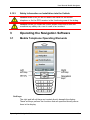
1
User Manual Mobile Navigator Symbian Edition English (UK) May 2009 Imprint NAVIGON AG Schottmüllerstraße 20A D-20251 Hamburg The information contained herein may be changed at any time without prior notification. This manual nor any parts thereof may not be reproduced for any purpose whatsoever without the express written consent of NAVIGON AG, nor transmitted in any form either electronically or mechanically, including photocopying and recording. All technical information, illustrations etc. are subject to copyright law. © 2009, NAVIGON AG All rights reserved. User Manual Mobile Navigator Table of Contents 1 Introduction .......................................................................................6 0H 85H 1.1 About This Manual ................................................................................... 6 1H 86H 1.1.1 1.1.2 1.1.3 2H 3H 4H 1.2 87H 8H 89H Legal Notice ............................................................................................. 7 5H 90H 1.2.1 1.2.2 6H 7H 1.3 Warranty ...................................................................................... 7 Trademarks ................................................................................. 7 91H 92H Customer Service..................................................................................... 7 8H 2 Arrangement ................................................................................ 6 Conventions................................................................................. 6 Symbols ....................................................................................... 6 93H Before You Start................................................................................7 9H 94H 2.1 Starting the Navigation Software.............................................................. 7 2.2 Two Modes of Operation .......................................................................... 7 10H 95H 1H 96H 2.2.1 2.2.2 12H 13H Test Mode.................................................................................... 8 Full Version.................................................................................. 8 97H 98H 2.3 Working with the Test Version.................................................................. 8 2.4 Acquiring the Full Version ........................................................................ 8 2.5 Activation.................................................................................................. 9 2.6 Installing the Software .............................................................................. 9 2.7 Connecting the GPS Receiver ............................................................... 10 14H 9H 15H 10H 16H 10H 17H 102H 18H 103H 2.7.1 2.7.2 19H 20H Integrated GPS Receiver........................................................... 10 External GPS Receiver.............................................................. 10 104H 105H 2.8 Installing the Hardware in a Vehicle ....................................................... 11 2.9 Telephone Power Supply ....................................................................... 11 21H 106H 2H 107H 2.10 Supplying Power to an External GPS Receiver ..................................... 11 23H 108H 2.11 Navigating with GPS .............................................................................. 11 24H 109H 2.12 Important Safety Information .................................................................. 12 25H 10H 2.12.1 Navigation Safety Information ................................................... 12 2.12.2 Safety Information for External GPS receivers.......................... 12 2.12.3 Safety Information on Installation into the Vehicle..................... 13 26H 1H 27H 12H 28H 3 13H Operating the Navigation Software ...............................................13 29H 14H 3.1 Mobile Telephone Operating Elements .................................................. 13 3.2 Operating the Software .......................................................................... 14 30H 15H 31H 16H 3.2.1 3.2.2 3.2.3 3.2.4 3.2.5 32H 3H 34H 35H 36H User Manual Highlighting and Activating ........................................................ 14 Options ...................................................................................... 14 Data Input .................................................................................. 14 Lists ........................................................................................... 15 Information................................................................................. 16 17H 18H 19H 120H 12H Table of Contents III User Manual Mobile Navigator 4 Navigation .......................................................................................18 37H 12H 4.1 General Information on Navigation......................................................... 18 38H 123H 4.1.1 39H 4.2 Safety and Other Information .................................................... 18 124H Starting Mobile Navigator ....................................................................... 19 40H 125H 4.2.1 4.2.2 41H 42H Initializing the GPS Receiver ..................................................... 20 Main menu ................................................................................. 21 126H 127H 4.3 Speed profile .......................................................................................... 21 4.4 Specifying a Destination......................................................................... 21 43H 128H 4H 129H 4.4.1 4.4.2 4.4.3 45H 46H 47H 4.5 Specifying Destination Country ................................................. 21 Destination Address .................................................................. 22 Points of Interest........................................................................ 23 130H 13H 132H Selecting a Saved Destination ............................................................... 26 48H 13H 4.5.1 4.5.2 4.5.3 4.5.4 49H 50H 51H 52H Last destinations........................................................................ 26 Favourites .................................................................................. 27 Contacts .................................................................................... 27 Using Destination Data from Received SMS............................. 28 134H 135H 136H 137H 4.6 Navigating Home.................................................................................... 29 4.7 Starting Navigation ................................................................................. 29 53H 138H 54H 5 139H Working with the Map.....................................................................30 5H 140H 5.1 Selecting a Map...................................................................................... 30 5.2 Activating an additional Map .................................................................. 31 5.3 Map in Standard mode ........................................................................... 32 5.4 Map in Pedestrian mode ........................................................................ 33 5.5 Map in Navigation mode......................................................................... 36 56H 57H 14H 142H 58H 143H 59H 14H 60H 145H 5.5.1 61H 6 GPS/current position ................................................................. 41 146H Services ...........................................................................................42 62H 147H 6.1 Buy Services .......................................................................................... 42 63H 148H 6.1.1 64H Activation of premium services and additional maps................. 43 149H 6.2 Weather info ........................................................................................... 43 6.3 Traffic Information (TMC) ....................................................................... 44 6.4 Services based on databases ................................................................ 46 65H 6H 67H 7 150H 15H 152H Configuring Mobile Navigator........................................................46 68H 153H 7.1 Opening the Settings Window ................................................................ 46 7.2 General................................................................................................... 47 7.3 Navigation .............................................................................................. 47 7.4 Signs ...................................................................................................... 48 7.5 Traffic ..................................................................................................... 48 7.6 GPS........................................................................................................ 48 69H 70H 71H 72H 73H 74H 154H 15H 156H 157H 158H IV Table of Contents 159H User Manual User Manual Mobile Navigator 7.7 My address............................................................................................. 49 7.8 Software version..................................................................................... 49 75H 76H 8 9 10 79H 78H 7H 160H 16H Glossary ..........................................................................................50 Transliteration .................................................................................51 Index ................................................................................................52 User Manual 162H 163H 164H Table of Contents V User Manual Mobile Navigator 1 Introduction 1.1 About This Manual 1.1.1 Arrangement If you are looking for specific information or the explanation of a specific term, you can refer to the following sections in the manual: 1.1.2 ▶ From page 50 in the Glossary you will find an explanation of the specialist terms and abbreviations used in this manual. ▶ As of page 52 in the Index you will find page references. 165H 167H 16H 168H Conventions For better legibility and clarification, the following styles are used in this manual: Bold and italic: Registered names, company and product descriptions. SMALL CAPITALS: Window and dialogue box titles. Descriptions of buttons, input fields and other elements in the user interface. Bold: [ ]: Description of a key on the mobile telephone, e.g. [OK]. < >: 1.1.3 Description of software, the function of which is displayed in the bottom line of the display, e.g. <Options>. Symbols The following symbols refer to specific passages of text: Notes and tips on operating the software More detailed information and explanations Warning information -6- Introduction User Manual Mobile Navigator 1.2 Legal Notice 1.2.1 Warranty The software and documentation are subject to change without notice. NAVIGON AG is not liable for the correctness of the information contained in this manual or for damages resulting from the use of this manual. To improve the quality of our products and services we appreciate all suggestions for improvement and notification of error. 1.2.2 Trademarks All brands and trademarks mentioned in this document are possibly registered by third parties and are subject to the current legislation and to the rights of their respective owners without reservation. All mentioned names of products, societies, or brands may be registered trademarks of their respective owners. Every right that is not explicitly accorded is reserved. The absence of an explicit labeling of registered trademarks does not suggest that this brand is not subject to third party rights. 1.3 ▶ Windows and ActiveSync are registered trademarks of the Microsoft Corporation. ▶ NAVIGON is a registered trademark of NAVIGON AG. Customer Service You have a question concerning your product? Please visit our website www.navigon.com. 80H 2 Before You Start 2.1 Starting the Navigation Software The procedure for starting the software can vary depending on the type of mobile phone. Refer to your mobile telephone’s user manual for more information. 2.2 Two Modes of Operation Mobile Navigator may be operated in two different modes. Before You Start -7- User Manual Mobile Navigator 2.2.1 Test Mode You may operate Mobile Navigator in a test mode for 30 days. During this period, the software may be used without restriction and with all available maps. This gives you the opportunity to assure yourself of the capability of the navigation software. 2.2.2 Full Version You will use the full version as soon as you have activated the software. For further information on acquiring the full version refer to "Acquiring the Full Version", page 8. 169H 170H 2.3 Working with the Test Version If the 30 days test period has not expired yet the software will start in test mode. Note: Even after the test period has expired you can still work with the test version. You can no longer use it to navigate, but you can still have it show you any position on the map. 2.4 Acquiring the Full Version Carry out the following steps to acquire the full version: 1. Press the <Options> softkey and select Activation in the main window. 2. Press the <Options> softkey and select Buy maps. The browser of the mobile phone opens. Note: You may be prompted to select an internet access point. Which access point you must select depends on your mobile phone service provider. Please get the relevant information there. 3. Please select which map you want to be activated with the full version. 4. Indicate the payment method. 5. Provide the required personal data. 6. Activate the Continue button. Within a few seconds you will receive an activation SMS. This will automatically activate the full version of the navigation software, along with the required map. You will as well receive an email with the serial number to the email address you have provided during the acquisition procedure. -8- Before You Start User Manual Mobile Navigator In case the automatic activation fails, please proceed as indicated in "Activation", page 9. 17H 2.5 172H Activation You may as well activate manually the full version of the navigation software (or additional maps). This may be necessary if the automatic activation via SMS had failed, or if you have reinstalled the navigation software on a different storage card. 1. Start the navigation software on the mobile phone. 2. Press the <Options> softkey and select Activation in the main window. 3. Press the <Options> softkey and select Enter serial number. 4. Enter the serial number you have received by SMS and by email. 5. Press the <OK> softkey. Note: You may be prompted to select an internet access point. Which access point you must select depends on your mobile phone service provider. Please get the relevant information there. A dialog box will inform you on the successful activation. The MAIN WINDOW of the navigation software opens. 2.6 Installing the Software The software needs not to be installed on the mobile phone. It may be started from the storage card. Note: We recommend using memory cards with at least 512 MB storage capacity. To use the map of Europe you need a memory card with at least 4 GB. Proceed as follows: 1. Insert a memory card suitable for your mobile phone into the card reader of your PC. - OR Insert a suitable memory card into the mobile phone. 2. Insert the Mobile Navigator DVD into your DVD drive. The Installer Tool will start automatically. - OR Double-click on the file "Setup.exe" from the download. 3. Select the language you want to use. 4. Click on Installation. Before You Start -9- User Manual Mobile Navigator 5. Make sure that the card reader is connected to the PC. - OR Connect the mobile phone to the PC. 6. Select the memory card drive. 7. Follow the instructions on the screen. Note: If you have already acquired the full version of the software, you will have to activate the copy on the new storage card. Proceed as described in "Activation", page 9. 173H 174H Note: If a DVD with navigation software was not supplied with your mobile phone, you can download the software and / or navigation maps from our website www.navigon.com/mn7. 81H 2.7 Connecting the GPS Receiver 2.7.1 Integrated GPS Receiver If a GPS receiver is integrated into your mobile phone, use it for navigation. Refer to your mobile phone's user manual for information on activating the integrated GPS receiver. In order to enable the best possible GPS reception, the mobile phone should be placed in an appropriate holder near the windscreen. 2.7.2 External GPS Receiver You need a Bluetooth enabled GPS receiver which supports the NMEA protocol if your mobile phone has no integrated GPS receiver, or if the integrated GPS receiver is out of service. 1. Switch on the GPS receiver. 2. Affix the GPS receiver flat on the dashboard - as close as possible to the windscreen. As soon as Mobile Navigator requires GPS data a Bluetooth connection is made with the GPS receiver. If the GPS receiver is not detected a dialogue opens. Here you can specify / search for the GPS receiver. (Refer also to "GPS", page 48) 175H 176H Refer to the device manual of your GPS receiver for more information. Note: The GPS reception can be affected if you have a heated or metal-evaporated windscreen. If necessary, use an external aerial. You can purchase an external aerial from our support team, via our online shop or from a specialized dealer. - 10 - Before You Start User Manual Mobile Navigator 2.8 Installing the Hardware in a Vehicle Telephone Cradle To safely operate the navigation system in a vehicle we recommend you use a special cradle for your mobile telephone. This way you can ensure that the display is always easy to see and that the driving instructions of the navigation system are easy to understand. You can purchase a special cradle for your mobile telephone from a specialized dealer. 2.9 Telephone Power Supply It is recommended that you connect your mobile telephone to an external power supply, especially when driving long journeys. From specialist dealers you can obtain cigarette lighter charger cables for virtually all mobile telephones. This cable is also often available online from the manufacturer of your mobile telephone. If you want to power several devices from your vehicle’s cigarette lighter, then use a multiple adapter that can be purchased from specialist dealers. 2.10 Supplying Power to an External GPS Receiver It is recommended to connect an external GPS receiver to an external power source, especially for longer trips. From specialist dealers you can obtain cigarette lighter charger cables for virtually all GPS receivers. This cable is also often available online from the manufacturer of your mobile telephone. If you want to power several devices from your vehicle’s cigarette lighter, then use a multiple adapter that can be purchased from specialist dealers. 2.11 Navigating with GPS GPS is based on a total of 24 satellites that circle the earth and, in doing so, are constantly transmitting their position and their time. The GPS receiver receives this data and calculates its own geographical position from the various position and time information broadcast by the different satellites. For a sufficient, precise positioning it is necessary to obtain the data from at least three satellites. If you have the data from 4 or more satellites the altitude above sea level can also be ascertained. The positioning is precise up to 3 meters. Before You Start - 11 - User Manual Mobile Navigator If Mobile Navigator has determined your position, this position can be used as a starting point for a route calculation. The map material includes the geographical coordinates of all digitally recorded points of interest, streets and places. From this the navigation system can calculate a route from a starting point to a destination. The calculation of the current position and its representation on the map takes place once every second. So you can see where you are on the map. 2.12 Important Safety Information It is in your own interest to read the following safety information and warnings carefully before you start up your navigation system. 2.12.1 Navigation Safety Information Use of the navigation system is executed at your own risk. Caution! To protect yourself and others from accidents please do not operate the navigation system while driving! Caution! Do not look at the display unless it is absolutely safe to do so! Caution! The rules of the road and traffic signs must be obeyed prior to following instructions from the navigation system. Caution! Do not follow the instructions of the navigation system unless circumstances and the road traffic regulations allow you to do so! The navigation system will automatically reroute you to your destination when you have gone off course. Note: If you have not understood the speech instructions or if you are unsure what you should do at the next crossroads, you can use the map or arrow view to orientate quickly. 2.12.2 Safety Information for External GPS receivers Caution! After installation, check all the safety-relevant facilities in the vehicle. Caution! Attach the GPS receiver in such a way that you can still drive safely. - 12 - Before You Start User Manual Mobile Navigator 2.12.3 Safety Information on Installation into the Vehicle Caution! Make sure you do not attach the cradle for the mobile telephone or for the GPS receiver in the functioning area of the airbag. Caution! When you install the cradle, please check that it does not constitute any safety risk, even in case of an accident. 3 Operating the Navigation Software 3.1 Mobile Telephone Operating Elements Soft keys The right and left soft keys are located directly beneath the display. These soft keys perform the functions that are specified directly above them in the display. Operating the Navigation Software - 13 - User Manual Mobile Navigator Navigation keys The navigation keys can be used to perform the [Up], [Down], [To the right] and [To the left] functions. The navigation keys can also be designed as a four-way directional pad, as a mini joystick or as a trackball. OK key Executes the function of the selected element. The Navigation keys and the OK key may also be designed as a trackball or as a joystick. Refer to your mobile telephone’s user manual for more detailed information. 3.2 Operating the Software 3.2.1 Highlighting and Activating Highlight On each Mobile Navigator window a button or input field is highlighted. This element has the focus. Using the navigation keys you can move the focus to a different element on the user interface. The highlighted element is the element with the focus. Activate To activate the button with the focus, press the [OK] key of your mobile telephone. 3.2.2 Options Some windows offer options that include further functions. Press the left soft key <Options> in order to open the list of options. Select Use the navigation keys to select an option. Press the [OK] key or the left soft key <Select> in order to execute the selected option. To close the list of options without executing an option press the right soft key <Cancel>. 3.2.3 Data Input If text or number input is required a cursor appears in an entry field on the display. You can make all the entries using your mobile telephone keyboard. - 14 - Operating the Navigation Software User Manual Mobile Navigator As, when making entries in Mobile Navigator, it concerns almost exclusively numbers or proper names, the T9 functionality of your mobile telephone is deactivated. However, as soon as you close Mobile Navigator, the keyboard returns to the state it was in prior to launching the navigation software. Characters As usual, each character key has several characters assigned to it. Press a key until the desired character appears. (E.g. to enter “s” you need to press the “PQRS” key four times) Numbers You can enter numbers by pressing on the respective key of your mobile telephone until the number appears or keeping the key pressed until the figure appears. Spaces, uppercase letters, special characters How you enter spaces, uppercase letters or special characters very much depends on your mobile telephone. Refer to your mobile telephone’s user manual for more information. When entering place or street names you do not have to differentiate between upper- and lowercase letters. You also do not have to enter any special characters or umlauts. Mobile Navigator will find the place or the street even if you enter basic characters. If, for example, you are searching for “München”, then simply type in “munchen”. Special characters or umlauts can of course be useful when naming destinations or routes that are to be saved. Deleting characters The character directly in front of the cursor can be deleted by pressing the [C] key. Moving the cursor If you wish to delete a character other than the last one or would like to insert a character in a part other than right at the end of the text, then you must move the cursor to the respective position. The position of the cursor in the entry field can be changed with the [To the left] and [To the right] keys. 3.2.4 Lists If you are entering letters and pause, lists will appear from which you can select an entry. This is the case, for example, when you enter a location. Operating the Navigation Software - 15 - User Manual Mobile Navigator If you wait a moment after entering the first letter, the largest town which begins with this letter in the country in question will appear. If you wait a moment after entering more letters, a list will appear with all the locations which begin with the letters you have entered so far. If more than 10 entries are found, the entry More... is shown at the end of the list. Select this entry in order to display more entries. As you enter other characters, the list changes respectively. It only includes entries that begin with the specified text. The more characters you enter, the shorter the list becomes. If a street name or name of a point of interest consists of several words, you can enter just the start of each of these words. For example, to search for e.g. “Charles Haller Street” you can make an entry that starts both with “CHA…” as well as “HAL…”. In the case of town names that consist of several words, you can only enter the first letters of the first word. Then an entry in the list must be accepted by selecting it and then pressing the [OK] key. The focus then moves to the next operating element of the window. If the next operating element is again an entry field, then the cursor in this field flashes and you can then enter the respective data. 3.2.5 Information Symbols located at the top of the screen are used to display information. - 16 - Operating the Navigation Software User Manual Mobile Navigator Traffic Information (TMC) If you have subscribed to the Traffic premium service, the navigation system will have access to the latest traffic messages. If necessary it can change your route dynamically, for example in order to avoid a traffic jam. The TMC symbol can display the following TMC reception status: No Symbol: The Traffic function is deactivated. (Refer to "Configuring Mobile Navigator" on page 46) 17H 178H Cannot connect: The Traffic function is activated but no data have been called yet from the server. Maybe an error occurred while the data were being called. This can be the case if you have not subscribed to the Traffic premium service or if no mobile phone reception is possible at the moment (e.g. in a tunnel). TMC on Standby: Traffic messages can be received. No errors occurred while the data were being called from the server. The Traffic service is described in the chapter "Traffic Information (TMC)" on page 44. 179H 180H Note: Read the information concerning the costs of data traffic at the beginning of the chapter "Services" on page 42. 18H 182H GPS The GPS icon can display the following states of the GPS reception: No GPS: The internal GPS receiver is deactivated or out of service; or no external GPS receiver is connected to the mobile phone. No Signal: The data is being received from less than three satellites. The position cannot be calculated. GPS ready: The data is being received from at least three satellites. The position can be calculated. Refer to chapter "GPS/current position” page 41 for detailed information regarding the GPS status. 183H Operating the Navigation Software 184H - 17 - User Manual Mobile Navigator Energy The Energy icon can display the following states of the built-in battery: The device is being supplied by an external power source. The battery is being charged. The device is being supplied by its internal battery. The battery is insufficiently charged. The device is being supplied by its internal battery. The battery charge is too weak. Received position If you are receiving an SMS with positioning data, a small envelope appears in the top right corner of the display alongside the GPS icon. It remains visible there until you open the RECEIVED POSITION list (refer to page 27). 185H If, when receiving an SMS with positioning data, the navigation software is not open, then it will open automatically. 4 Navigation 4.1 General Information on Navigation 4.1.1 Safety and Other Information Use of the navigation system is executed at your own risk. Caution! To protect yourself and others from accidents please do not operate the navigation system while driving! Caution! Do not look at the display unless it is absolutely safe to do so! Caution! The rules of the road and traffic signs must be obeyed prior to following instructions from the navigation system. Caution! Do not follow the instructions of the navigation system unless circumstances and the road traffic regulations allow you to do so! The navigation system will automatically reroute you to your destination when you have gone off course. - 18 - Navigation User Manual Mobile Navigator Obstructed GPS reception If the GPS is reception is obstructed, or if you switch off the GPS receiver before you reach the destination, the navigation will stop. However, the navigation software remains open. As soon as the GPS receiver is ready to function again, the navigation system notices if your position has since changed and automatically recalculates the route. You can simply continue navigation. Quitting navigation If you quit the navigation prior to reaching your destination, the MAIN opens. You can then enter a different destination. You can also resume navigation to the original destination by choosing it from the LAST DESTINATIONS list. MENU Reaching the destination The system makes an announcement when you have reached your destination. Only your current position (orange arrow) is shown on the map. Exit Mobile Navigator If you wan to exit the navigation software, press <Exit> on the MAIN MENU. 4.2 Starting Mobile Navigator 1. Switch on your mobile telephone. 2. Start the Mobile Navigator software. The procedure for starting the software depends on your make of telephone. Refer to your mobile telephone’s user manual for more information. Each time you start the navigation software, the following information appears: "Please note that the road traffic regulations take priority over the instructions of the navigation system. Please do not operate the device while driving." 1. When you have read the text completely, press <OK>. 2. If you do not wish to accept this information, press <Exit> in order to close the navigation software. The MAIN MENU opens. If the GPS receiver is connected to the mobile telephone, you will see the GPS icon in the top right corner of the display. Navigation - 19 - User Manual Mobile Navigator 4.2.1 Initializing the GPS Receiver Connecting the GPS receiver is described in "Connecting the GPS Receiver", page 10. 186H 187H Note: It can take up to 20 minutes to initialize the GPS receiver for the first time. Each time you switch on the receiver after this, the GPS reception will start within one minute. If the GPS receiver has been switched off for over a week, the next initialization can take up to 10 minutes. As soon as the GPS receiver is switched on it starts initializing. As soon as the navigation software receives data from a GPS receiver, the GPS icon may be seen in the upper right corner of the screen. It can display three different states: No GPS: The internal GPS receiver is deactivated or out of service; or no external GPS receiver is connected to the mobile phone. No Signal: The data is being received from less than three satellites. The position cannot be calculated. GPS ready: The data is being received from at least three satellites. The position can be calculated. Within 15 seconds the GPS icon changes to No Signal. As soon as the data is being received from at least 3 satellites, the GPS icon changes to GPS ready. Note: If the GPS icon displays the GPS ready status after considerably less than 20 minutes, then it is best to wait for at least a further 15 minutes so as to guarantee reliable operation of the receiver. Caution! If you have connected an external GPS receiver to the cigarette lighter for power supply, remove the connector before leaving the vehicle standing for a long period of time. As the GPS receiver requires a constant supply of power, it could drain the vehicle's battery. Find detailed information - 20 - ▶ on an external GPS receiver in the GPS receiver's user manual. ▶ on an internal GPS receiver in the mobile phone's user manual. Navigation User Manual Mobile Navigator 4.2.2 Main menu You can access all the functions of the navigation software from the MAIN MENU. Opening the Main Screen If a different window is open you can always easily return to the main window. 1. Press the <Options> soft key. 2. Select Main menu. 4.3 Speed profile First enter the mode of transport you wish to use for the journey or if you want to go on foot, and then enter how you want the route to be calculated. 1. Open the MAIN MENU (refer to page 21). 18H 2. Press <Options> and select Settings. The SETTINGS window opens. You can use the [Up] and [Down] navigation keys to scroll in the list of settings. 3. Actuate the Navigation button. 4. Select Pedestrian route, Bike, Car or Lorry. 5. Select the desired settings in the other boxes. (Refer to "Navigation" on page 47) 189H 190H 6. Press <Options> and select Main menu. Note: Once you have entered the destination, you can no longer change the route profile. Before you enter the destination it is important therefore to make sure that you have made the settings you want. 4.4 Specifying a Destination 4.4.1 Specifying Destination Country You can only search for places and points of interest within a specific country. The country is indicated on the Country button in the top right corner of the display. 1. If the location or point of interest is located in a different country, then activate the Country button. All the countries that the current map includes are listed beneath the Country button. Navigation - 21 - User Manual Mobile Navigator 2. Highlight the country in which the destination is located. 3. Press [OK]. 4.4.2 Destination Address Note: Names of cities and streets in countries with Cyrillic letters (Bulgaria, FYR Macedonia, Serbia, Ukraine, Belarus) are stored in the map using only Latin letters. 1. In the MAIN MENU activate the Navigation button. 2. Activate the Navigate to button. The NAVIGATE TO window opens. The City or postal code entry field is highlighted, and the cursor can be seen inside it. Note: Also ensure that the country in which your destination is located is specified on the Country button. (Refer to "Specifying Destination Country” page 21) 19H 192H 3. Enter the destination in the City or postal code field. You can enter either the postcode or the name. 4. Enter the name of the destination street in the Street field. 5. Enter the house number in the No. field. If you do not know the house number, then leave this field empty. 6. If you do not know the house number, but you do know the name of an intersecting road in its vicinity, then enter this name in the Crossroad field. Mobile Navigator then calculates a route to the intersection of both specified roads. Refer to chapter "Starting Navigation" on page 29 for information on how to start navigating. Please read on there. 193H 194H Press the <Options> softkey and select ▶ Show map, in order to show the destination on the map ▶ Save destination, in order to save the destination in the FAVOURITES list ▶ Weather info in order to display the current weather and a weather forecast for the selected location. (Refer to "Weather info" on page 43) 195H 196H - 22 - Navigation User Manual Mobile Navigator 4.4.3 Points of Interest Points of Interest, also known as POI, are included in the map server’s database. It concerns addresses or points on the map that are categorized according to specific criteria. Included as points of interest are airports and harbors, restaurants, hotels, petrol stations, public facilities, doctors, hospitals, shopping centers and others. Points of interest are marked on the map by means of a symbol and can also be specified as a destination for the navigation. Points of Interest Nearby Points of interest nearby are points of interest that are located within a specific radius of your current location. This way you can, for example, always find the next petrol station with ease, irrespective of your location. Note: Points of interest nearby can only be specified if a GPS receiver is connected and the GPS reception is sufficient for positioning. 1. In the MAIN MENU activate the Navigation button. 2. Activate the Point of interest button. 3. Activate the nearby button. The POI NEARBY window opens. The Category field is highlighted. 4. Use the [To the right] and [To the left] keys, in order to specify the category from which you want to find a point of interest. 5. Press [OK]. The Sub category field is highlighted. 6. Use the [To the right] and [To the left] keys in order to specify a subcategory. If you do not want to define a subcategory specify All categories. 7. Press [OK]. The cursor flashes in the POI/Name field. 8. If you know the name of the point of interest (e.g. the name of a restaurant), then you can enter this name either in whole or in part in the POI/Name field. In this case, specify All categories as category and subcategory. 9. If you do not know the name, then leave this field empty. 10. Press [OK]. All the destinations of the specified category / subcategory that are located in your current location are listed under the POI/Name field. Navigation - 23 - User Manual Mobile Navigator 11. Highlight the destination to which you wish to navigate. 12. Press [OK]. Refer to chapter "Starting Navigation" on page 29 for information on how to start navigating. Please read on there. 197H 198H Press the <Options> softkey and select ▶ Show map, in order to show the destination on the map ▶ Save destination, in order to save the destination in the FAVOURITES list ▶ Weather info in order to display the current weather and a weather forecast for the selected location. (Refer to "Weather info" on page 43) 19H 20H Points of Interest of Nationwide Significance Points of interest of nationwide significance are airports, attractions and monuments of national significance, large harbors and the like. 1. In the MAIN MENU activate the Navigation button. 2. Activate the Point of interest button. 3. Activate the nationwide button. The POI OF NATIONAL SIGNIFICANCE window opens. The Category field is highlighted. Note: Also ensure that the country in which your destination is located is specified on the Country button. (Refer to "Specifying Destination Country” page 21) 201H 20H 4. Use the [To the right] and [To the right] keys, in order to specify the category from which you want to find a point of interest. 5. Press [OK]. The cursor flashes in the POI/Name field. 6. Enter the name of the point of interest either in whole or in part. 7. Press [OK]. All the destinations of the specified category their names of which start or include the entered characters are listed under the POI/Name field. 8. Highlight the destination to which you wish to navigate. 9. Press [OK]. - 24 - Navigation User Manual Mobile Navigator Refer to chapter "Starting Navigation" on page 29 for information on how to start navigating. Please read on there. 203H 204H Press the <Options> softkey and select ▶ Show map, in order to show the destination on the map ▶ Save destination, in order to save the destination in the FAVOURITES list ▶ Weather info in order to display the current weather and a weather forecast for the selected location. (Refer to "Weather info" on page 43) 205H 206H Points of Interest in a Specific City Points of interest in a specific city can be useful when navigating in an unknown city. 1. In the MAIN MENU activate the Navigation button. 2. Activate the Point of interest button. 3. Activate the in a town button. The POI IN A CITY window opens. The cursor flashes in the City or postal code field. Note: Also ensure that the country in which your destination is located is specified on the Country button. (Refer to "Specifying Destination Country” page 21) 207H 208H 4. Enter the name or the post code of the location. 5. Press [OK]. The Category field is selected. 6. Use the [To the right] and [To the right] keys, in order to specify the category from which you want to find a point of interest. 7. Press [OK]. The Sub category field is selected. 8. Use the [To the right] and [To the right] keys in order to specify a subcategory. If you do not want to define a subcategory specify All categories. 9. Press [OK]. The cursor flashes in the POI/Name field. 10. If you know the name of the point of interest (e.g. the name of a restaurant), then you can enter this name either in whole or in part in the POI/Name field. In this case, specify All categories as category and subcategory. Navigation - 25 - User Manual Mobile Navigator 11. If you do not know the name, then leave this field empty. 12. Press [OK]. All the destinations of the specified category / subcategory that are located in the specified location are listed under the POI/Name field. 13. Select the destination to which you wish to navigate. 14. Press [OK]. Refer to chapter "Starting Navigation" on page 29 for information on how to start navigating. Please read on there. 209H 210H Press the <Options> softkey and select ▶ Show map, in order to show the destination on the map ▶ Save destination, in order to save the destination in the FAVOURITES list ▶ Weather info in order to display the current weather and a weather forecast for the selected location. (Refer to "Weather info" on page 43) 21H 21H 4.5 Selecting a Saved Destination The following lists of destinations and addresses are available for selection from My destinations in Mobile Navigator: 4.5.1 ▶ FAVOURITES: all the destinations that you have saved in Mobile Navigator. ▶ LAST DESTINATIONS: all the destinations to which you have already navigated before. ▶ CONTACTS: all the addresses from the mobile phone's contact list. ▶ RECEIVED POSITION: all the destinations that were sent to you from Mobile Navigator on another user's mobile phone. Last destinations Mobile Navigator saves the last 20 destination to which you have launched navigation, in the LAST DESTINATIONS list. You can select these destinations quickly as navigation destinations and without repeating the already entered data. 1. In the MAIN MENU activate the My destinations button. 2. Activate the Last destinations button. The LAST DESTINATIONS window opens. - 26 - Navigation User Manual Mobile Navigator 3. Highlight the destination to which you wish to navigate. 4. Press [OK]. The route is calculated. When the calculation is concluded, the map is shown. Refer to chapter "Starting Navigation" on page 29 for information on how to start navigating. Please read on there. 213H 214H Press the <Options> softkey and select ▶ Show map, in order to show the destination on the map ▶ Save destination, in order to save the destination in the FAVOURITES list ▶ Delete, to delete the highlighted destination from the LAST list. DESTINATIONS 4.5.2 Favourites Destinations to which you want to drive frequently can be saved in the FAVOURITES list. You can select these destinations quickly as navigation destinations and without repeating the already entered data. 1. In the MAIN MENU activate the My destinations button. 2. Activate the Favourites button. The FAVOURITES window opens. 3. Highlight the destination to which you wish to navigate. 4. Press [OK]. The route is calculated. When the calculation is concluded, the map is shown. Refer to chapter "Starting Navigation" on page 29 for information on how to start navigating. Please read on there. 215H 216H Press the <Options> softkey and select 4.5.3 ▶ Show map, in order to show the destination on the map ▶ Delete, to delete the highlighted destination from the FAVOURITES list. Contacts Contacts from your mobile phone's contacts list whose address you have saved can be selected as destination quickly and without repeating the entry of the address details. Navigation - 27 - User Manual Mobile Navigator 1. In the MAIN MENU activate the My destinations button. 2. Activate the Contacts button. The CONTACTS list opens. It contains only those contacts whose address you have saved. 3. Mark the contact to which you wish to navigate. 4. Press [OK]. 5. The saved address of the selected contact displays. Refer to chapter "Starting Navigation" on page 29 for information on how to start navigating. Please read on there. 217H 218H Press the <Options> softkey and select ▶ Show map in order to show the destination on the map ▶ Save destination in order to save the destination in the FAVOURITES list ▶ Weather info in order to display the current weather and a weather forecast for the selected location. (Refer to "Weather info" on page 43) 219H 20H 4.5.4 Using Destination Data from Received SMS Note: You can only use data from SMS that has been sent to you from the mobile telephone of a different Mobile Navigator user. 1. In the MAIN MENU activate the My destinations button. 2. Activate the Received pos. button. The RECEIVED POSITION window opens. 3. Highlight the SMS with the destination to which you wish to navigate. 4. Press [OK]. The route is calculated. When the calculation is concluded, the map is shown. Refer to chapter "Starting Navigation" on page 29 for information on how to start navigating. Please read on there. 21H 2H Press the <Options> softkey and select - 28 - ▶ Show map, in order to show the destination on the map ▶ Save destination, in order to save the destination in the FAVOURITES list Navigation User Manual Mobile Navigator ▶ Delete, to delete the highlighted destination from the RECEIVED list. POSITION 4.6 Navigating Home In Mobile Navigator you can save one address as a home address. The navigation to this address can take place at any time by pressing just one button. Refer to chapter "My address" on page 49 for information on entering your address. 23H 24H 1. Actuate the Navigation button in the main window 2. Actuate the Take me home button. The route is calculated. When the calculation is concluded, the map is shown. If the home address hasn’t yet been entered, a window opens with an appropriate message. 2a Press <Options> and select Define in order to enter your home address now - or 2b Press <Back> in order to return to the MAIN MENU. 4.7 Starting Navigation If you have selected a saved destination (refer to "Selecting a Saved Destination", page 26) or have pressed the Take me home button in the MAIN WINDOW (refer to "Navigating Home", page 29), the route will be calculated automatically and the map opened. 25H 26H 27H 28H If you have specified a new destination (refer to "Specifying a Destination", page 21), activate the Start button. The route is calculated. The map is then shown in navigation mode and you can start your journey. 29H 230H The triangle in orange represents your current location. The route is highlighted in orange. Note: The calculation of the route uses a so-called route profile as a basis. Refer to chapter "Navigation" on page 47 for information on changing the route profile. 231H 23H No GPS Reception? If no sufficient GPS signal is being received, the message "Waiting for valid GPS position..." appears. Navigation - 29 - User Manual Mobile Navigator You have the following options: ▶ Wait until the GPS reception is sufficient. Navigation then commences automatically. ▶ Press <Cancel>. The MAIN MENU opens. Your destination is saved in the LAST DESTINATIONS list. 5 Working with the Map 5.1 Selecting a Map Additional maps can be found on the product DVD. If you want to use one of these maps, copy it to the memory card in your mobile phone.. Note: If a DVD with navigation software was not supplied with your mobile phone, you can download the software and / or navigation maps from our website www.navigon.com/mn7. 82H Note: During the test period, you may use any of the maps without restriction. Once you have activated the software, you may only use the map that you have acquired (including all smaller maps that are covered by it, i.e. if you have acquired the 'Europe' map, you may as well use the 'D-A-CH' map). Note: We recommend using memory cards with at least 512 MB storage capacity. To use the map of Europe you need a memory card with at least 4 GB. Proceed as follows: 1. Insert a memory card suitable for your mobile phone into the card reader of your PC. - OR Insert a suitable memory card into the mobile phone. 2. Insert the Mobile Navigator DVD into your DVD drive. The Installer Tool will start automatically. - OR Double-click on the file "Setup.exe" from the download. 3. Select the language you want to use. 4. Click on Installation. 5. Make sure that the card reader is connected to the PC. - OR Connect the mobile phone to the PC. - 30 - Working with the Map User Manual Mobile Navigator 6. Select the memory card drive. 7. Follow the instructions on the screen. 8. Start the navigation software on the mobile phone. Note: If you want to use a map you had not activated yet, you will have to activate it now. Find detailed information in the next chapter. 9. In the GENERAL settings screen, go to the Map item and select the new map. (Refer to "General” page 47) 23H 5.2 234H Activating an additional Map If you have activated the software with the 'Europe' map, then all the other maps covering European regions are activated as well. If you have activated a map covering a part of Europe and want to use another map now, you will have to activate that map before. 1. Press the <Options> softkey and select Activation in the main window. A window opens showing all the maps which you have already activated. 2. Press the <Options> softkey and select Buy additional maps. 3. Press the <Continue> softkey. The browser of the mobile phone will open. Note: You may be prompted to select an internet access point. Which access point you must select depends on your mobile phone service provider. Please get the relevant information there. 4. Select the map you want to be activated. 5. Indicate the payment method. 6. Provide the required personal data. 7. Activate the Continue button. Within a few seconds you will receive an activation SMS. This will automatically activate the required map. You will as well receive an email with the serial number to the email address you have provided during the acquisition procedure. In case the automatic activation fails, please proceed as indicated in "Activation of premium services and additional maps", page 43. 235H 236H Note: You can also carry out the activation on our website www.navigon.com/mn7. 83H Working with the Map - 31 - User Manual Mobile Navigator 5.3 Map in Standard mode The map is always in standard mode when you are not navigating. Show Current Location on the Map 1. In the MAIN MENU activate the Show map button. The map opens in standard mode. A triangle in orange shows your current location on the map. Press <Options> and select ▶ Save position, in order to save the data of your current location in the FAVOURITES list ▶ Send position, in order to send data of your current location per SMS to someone else’s mobile telephone upon which Mobile Navigator is also installed. In this way, e.g. he can start navigating immediately without having to enter the destination data himself. Show a New Destination on the Map 1. Specify a new destination as described in chapter "Specifying a Destination" on page 21. 237H 238H The destination is highlighted. 2. Press <Options> and select Show map. The map opens in standard mode. A red circle identifies the specified destination on the map. Changing the Map Section - 32 - ▶ Pan: Use the navigation keys [Up], [Down], [To the right] and [To the left] to scroll the map. ▶ Zoom in: Press the [1] key. The section shown becomes smaller, but the precision of detail increases. ▶ Zoom out: press the [2] key. The section shown becomes larger, but the precision of detail reduces. ▶ Center position: Press the [3] key if you have moved the map and want to show the current position or the destination again in the centre of the display. Working with the Map User Manual Mobile Navigator 5.4 Map in Pedestrian mode Overview If you are on foot, the guidance provided by navigation systems for vehicles is often unsatisfactory because they "know" only routes which can be taken by motor vehicles. Foot paths, for example through parks, are not recorded in these systems. Furthermore, their software was developed for speeds well above walking pace. Navigation in Pedestrian mode differs from navigation for vehicles. You receive a route suggestion which is calculated on the basis of "known" streets. In addition you are always shown in which direction your destination lies. If you leave the suggested route, for example in order to take an attractive path through a park, you can still see in which direction you have to go. Please note: ▶ You will not receive any navigation instructions. ▶ The route will not be re-calculated automatically if you depart from the route. ▶ The map does not turn when you change direction. The displayed section of the map does shift however so that your position is always in view at the same point of the screen. ▶ The map is aligned so that your destination is at the top. ▶ You do not receive a message when you arrive at your destination. View of the map in Pedestrian mode 1 Red triangle: Indicates in which direction your destination lies. Working with the Map - 33 - User Manual Mobile Navigator 2 Blue triangle: Indicates in which direction you are moving. 3 Yellow circle: Indicates your position on the map. 4 Distance to your destination (linear distance) 5 Compass indicates where north is. 6 Presentation of the most important functions: ▶ [Up], [Down], [To the right], [To the left]: You can use these functions to scroll in the map. If you shift a section of the map, it will no longer change when you move on. In other words you can "walk off" the map. Press the [3] key on your mobile phone if you want the map to follow your movements again. ▶ The other functions are described in the next chapter. Using the map All functions that are available during navigation can be executed by means of short cuts. This means that the numerals [0 - 9] on the mobile phone are assigned to particular functions, which can be carried out by pressing the associated button. Press the left softkey to see which shortcuts are available. The SHORTCUTS menu opens. The function assigned to each of the buttons is depicted by a symbol. The key to which the function is assigned is shown in the upper left hand corner. When you press the assigned key, the function will be carried out without previously having to open the SHORTCUTS menu (see next chapter). The function of the marked button and the key to which it is assigned are shown on the lower edge of the menu. - 34 - Working with the Map User Manual Mobile Navigator If you do not carry out a function, the menu closes automatically a few seconds later. Map shortcuts in Pedestrian mode Key [1] Zoom in: Increases the scale. You see more details but fewer streets. Key [2] Day/Night: Switches between day and night modes. Key [3] Centre position: Shows your current position on the map again if you shifted the map section. Now your position always remains at the same point of the screen, i.e. the map section is shifted when you move. Key [4] Zoom out: Decreases the scale. You see fewer details but more streets. Key [5] Recalculate route: Re-calculates the route. Use this function if you have departed too far from the calculated route and no longer know where you are. Key [6] Route overview: Zooms the map so that the complete route (from the starting point to the destination) is presented on the screen. Key [7] Send position: Initiates the transfer of data pertaining to your current position via SMS. Key [8] Quit navigation: Exits navigation. A dialogue box prompts you to confirm. Key [9] GPS status: Opens the GPS/CURRENT POSITION window. Here you can see details regarding GPS reception. (Refer to "GPS/current position" on page 41.) 239H 240H Working with the Map - 35 - User Manual Mobile Navigator 5.5 Map in Navigation mode Using the Map All functions that are available during navigation can be executed by means of shortcuts. This means that the keys [0 – 9] on your mobile are assigned specific functions that are executed when the respective key is pressed. Press the left soft key in order to see which shortcuts are available. The SHORTCUTS menu opens. The associated function on each button is shown by means of a symbol. In the top left corner you can see which key is assigned to the function. If you press the assigned key, then this function is carried out directly without having to open the SHORTCUTS menu first (refer to the next chapter). The function of the highlighted button and the key that it is assigned to is described along the bottom of the menu. If you do not execute a function, the menu closes again after a few seconds. The Shortcuts of the Map in Navigation mode Key [1] Instruction: Repeats the last spoken driving instruction. Key [2] Mute: Makes the navigation software mute so that you no longer receive any spoken driving instructions. Press this button again in order to cancel the muting. - 36 - Working with the Map User Manual Mobile Navigator Attention: The mobile telephone itself isn’t muted by this function. Key [3] Route info: Toggles during navigation between the display for the estimated arrival time, the remaining driving time and the remaining distance away from the destination. Key [4] Day/Night: Toggles between day and night mode. Key [5] Switch view: Opens the MAP VIEW menu. From here you can select a different view. You can press the navigation keys [To the right] or [To the left] in order to change the view without going via the MAP VIEW menu. Key [6] Zoom mode: Enables you to zoom in the map and move the map section shown. (Refer to "Changing the Map Section", page 32) 241H 24H Key [7] Send position: Initiates sending the data of your current location as an SMS. Key [8] Traffic: Calls the latest traffic messages from the server and shows them. Key [9] GPS status: Opens the GPS/CURRENT POSITION window. Here you can view details regarding the GPS reception. Refer to chapter "GPS/current position, page 41 for more information. 243H 24H Selecting the View As soon as the navigation system has calculated the first driving instructions, the map opens in 2D. The size of the map section shown depends on your speed. The slower you drive, the smaller the map detail, but the precision of detail is greater. During navigation you can select other views – these don’t necessarily show a map but are particularly suitable for a specific purpose. There are five different views available. To select a different view, proceed as follows: 1. Press the [5] key. Working with the Map - 37 - User Manual Mobile Navigator The MAP VIEW menu opens. 2. Press the button for the desired view. Note: To change the view quickly in navigation mode you can also press the navigation keys [To the right] or [To the left]. Information During Navigation During navigation you are shown various pieces of information that are useful for the journey: View 2D navigation map - 38 - Working with the Map User Manual Mobile Navigator View 3D navigation map Schematic view 1 The route is indicated in orange. 2 A triangle in orange shows your current position on the map. 3 One of the following pieces of route information is shown in the information field: ▶ Estimated arrival time ▶ Remaining distance ▶ Estimated remaining driving time. Toggle between this information by using the [3] (Route info) key. 4 The street field shows the name of the section of street that you must drive on next. Working with the Map - 39 - User Manual Mobile Navigator 5a The arrow field shows schematically the next driving maneuver that is to be performed. 5b The distance field shows you at what distance the driving maneuver shown above should be carried out. When you are approaching the location where the next maneuver is to be carried out, the distance information changes to a point display. The more yellow points showing, the closer you are to the crossroads. If you do not have to turn for a while yet, an arrow points upwards stating a distance beneath it that indicates how far you must follow the street. 6 In the case of driving maneuvers that need to be carried out quickly in succession, the small arrow field will show the next but one maneuver. 7 Any applicable speed restriction is shown in the Speed limit area. The speed limit is shown in the unit of measure that is used to show speed in the country in which you are currently traveling. This field can be hidden. 8 If you are to follow specific signposting, then this signposting is shown here. Caution! The display of speed limits and the warning in the event of exceeding speed depends on the settings that you have made in the settings window SIGNS. (refer to "Signs", page 48) 245H 246H Caution! The information in the map material could be incorrect on account of sudden changes (construction sites etc.)! The traffic situation and signs must be obeyed prior to following the instructions of the navigation system. Route overview The ROUTE OVERVIEW shows the entire route on the display. This way you can quickly get a rough overview of the whole route that lies before or behind you. The route is shown in the color orange. The destination is marked by a small flag. A triangle in orange shows your current position on the map. - 40 - Working with the Map User Manual Mobile Navigator View Route info This view does not show a map. It clearly represents the various information in table form. 5.5.1 ▶ Speed: The current speed ▶ Distance: The remaining distance until reaching the destination specified below ▶ Duration: Remaining driving time until reaching the destination specified below ▶ Arrival: Estimated arrival time at the destination specified below ▶ Destination: Address or name of the destination to which you are currently navigating. GPS/current position On the GPS/CURRENT POSITION window you will find an overview of the data that the navigation system has extracted or calculated from the received GPS signals. The GPS/CURRENT POSITION window can only be displayed during navigation. ▶ Press the [9] key of the mobile telephone. (Refer also to: "The Shortcuts of the Map in Navigation mode", page 36) 247H 248H You will find the following information in the GPS/CURRENT POSITION window: GMT: Greenwich Mean Time: The time in London. If you are in a different time zone, then this time does not correspond to your location. Satellites: The number of GPS satellites that are receiving at present. To establish the current location you must be receiving signals from at least 3 satellites. HDOP: A measure for the quality of the location detection. The smaller the value is the more precise is the location detection. Values up to 8 are acceptable for navigation. Longitude, Latitude: The coordinates of the current location. Altitude: Height above sea level. To calculate the altitude you must be receiving signals from at least 4 GPS satellites. Speed: The current speed Working with the Map - 41 - User Manual Mobile Navigator Press <Options> and select 6 ▶ Send position, in order to send data of your current location per SMS to someone else’s mobile telephone upon which Mobile Navigator is also installed. In this way, e.g. he can start navigating immediately without having to enter the destination data himself. Note: It costs money to send an SMS! Consult your mobile telephone provider for details on the costs of sending an SMS. ▶ Save position, in order to save the data of your current location in the FAVOURITES list. Services Services are useful additional functions, for example weather information, traffic messages and others. There are services which can be used without charge, e.g. the weather service, and premium services which can be used in return for a paid subscription. Note: Every service causes data traffic when used. Connecting to the Internet and downloading the data can incur costs. For details of the charges involved ask your mobile telecom provider. Note: When activating and using services you may be requested to select an Internet access point. Which access point you must select depends on your mobile telecom provider. Please ask there for details. 6.1 Buy Services Note: You can subscribe to premium services either by mobile phone or on our website www.navigon.com/mn7. How to subscribe to a service using your mobile phone is described in the following. 84H Note: If you do not yet have the full version of the navigation software, then you cannot subscribe to any premium services using your mobile phone. Premium services can be used only with the full version of the software. (Refer to "Acquiring the Full Version" on page 8). 249H 250H 1. Press the <Options> softkey and select Activation in the main window. A window opens showing all the maps which you have already activated. 2. Press the <Options> softkey and select Buy Services. 3. Press the <Continue> softkey. - 42 - Services User Manual Mobile Navigator The browser of the mobile phone will open. 4. Select the service you want to subscribe to. 5. Indicate the payment method. 6. Provide the required personal data. 7. Activate the Continue button. Within a few seconds you will receive an activation SMS. Shortly afterwards, the service will be activated automatically. An e-mail with the serial number will also be sent to the e-mail address which you quoted when placing the order. If the automatic activation fails, proceed as described in the chapter "Activation of premium services and additional maps" on page 43. 251H 6.1.1 25H Activation of premium services and additional maps If the automatic activation fails, proceed as follows: 1. Press the <Options> softkey and select Activation in the main window. A window opens showing all the maps and services which you have already activated. 2. Press the <Options> softkey and select Enter serial number. 3. Enter the serial number which you received by SMS and/or by email. 4. Press the <OK> softkey. A dialog box will inform you about the successful activation. The main window of the navigation software opens. 6.2 Weather info The Weather info service is always available and does not require a subscription. The Weather info service provides a 3-day weather overview for a selected location. The location you select must be included on the map. 1. Actuate the Services button in the main window. 2. Actuate the Weather info button. The WEATHER INFO window opens. 3. Enter the location for which you would like to receive a weather overview. You can also enter the postal code. 4. Press [OK]. The weather overview appears. ▶ Services Use the <Back> softkey to close the weather overview. - 43 - User Manual Mobile Navigator 6.3 Traffic Information (TMC) You can subscribe to the Traffic premium service. The navigation system then has access to the latest traffic messages. If necessary it can change your route dynamically, for example in order to avoid a traffic jam. Note: The Traffic service is not available if GPS reception is not good enough for determining your position. Traffic messages are called from a server via an Internet connection. During navigation the data is called every 10 minutes, otherwise on demand. Note: Read the information concerning the costs of data traffic at the beginning of the chapter "Services" on page 42. 253H 254H Displaying traffic information Without navigation If navigation is not in progress, you can view the traffic messages for a radius of approx. 40 km around your current position. 1. Actuate the Services button in the main window. 2. Actuate the Traffic button. The TRAFFIC INFORMATION window opens. For each traffic message in the list you are shown information about the location of the traffic obstruction and its type. Above the list the Traffic Information button indicates the type of traffic information listed and how many messages of this type there are in the list. ▶ Using [To the right] and [To the left] you can select which messages you want to have displayed. ▶ You can use the <Back> softkey to close the TRAFFIC INFORMATION window. During navigation During navigation you can all up the traffic messages for the next 50 km of your route. In addition you can view the traffic messages for a radius of approx. 40 km around your current position. 1. Press the [8] key on your mobile phone. The TRAFFIC INFORMATION window opens. - 44 - Services User Manual Mobile Navigator Above the list the Traffic Information button indicates the type of traffic information listed and how many messages of this type there are in the list. ▶ Using [To the right] and [To the left] you can select which messages you want to have displayed. For each traffic message in the list you are shown information about the location of the traffic obstruction and its type. ► Using [Down] and [Up] select a message and press [OK] in order to have it displayed in detail. The navigation system can Detour ( ) or Ignore ( on the route. The button shows the active status. ► ► ) congestion Select the button and press [OK] in order to select the alternative setting. You can use the <Back> softkey to close the TRAFFIC INFORMATION window. Settings TMC ► In the TRAFFIC INFORMATION window press the <Settings> softkey. In the SETTINGS TMC window you can configure for example whether and how the reception of a traffic message concerning your route should affect the navigation. Avoid traffic jams Select Avoid traffic jams and use [To the right] and [To the left] to define how new traffic messages concerning your route should be taken into account. ► ► ► Off: No data are called from the server. No detour routes are calculated. You are not informed about traffic obstructions. Automatically: An alternative route will be calculated automatically. The system will inform you on the recalculation. Manually: A window opens with information about the location and type of traffic obstruction. You can then decide whether an alternative route is to be calculated or not. Message timeout Select Message timeout and use [To the right] and [To the left] to define after how much time the window with information about a traffic obstruction should be closed again. Services - 45 - User Manual Mobile Navigator Note: The Message timeout box is only effective (and can only be selected) when the value for Avoid traffic jams is set to Manually. 6.4 Services based on databases Many services are based on databases. These are lists of POIs which are updated regularly. The POIs are shown on the map. If you subscribe for example to the service "Radar Info", you will receive a visual and acoustic warning when you approach a permanently installed speed trap. 7 Configuring Mobile Navigator 7.1 Opening the Settings Window The SETTINGS window is the starting point for all adaptations that you can use to set up Mobile Navigator in accordance with your personal requirements. 1. Open the MAIN MENU (refer to page 21). 25H 2. Press <Options> and select Settings. The SETTINGS window opens. You can scroll through the list of settings using the navigation keys [Up] und [Down]. 3. Press the button ▶ General, if you wish to change the map, the volume, the display lighting, the power saving mode, the language, the time format or the unit of measurement. ▶ Navigation, in order to set which route profile should take the basis of the route calculation. ▶ Signs, to set whether the direction information and speed limits should be displayed on the map. ▶ Traffic, in order to configure how new traffic messages concerning your route should be taken into account. (Refer to page 44) 256H - 46 - ▶ GPS, in order to select the Bluetooth-compatible GPS receiver with which your mobile telephone can be connected if required. ▶ My address, in order to enter or alter your home address. ▶ Software version, in order to display information about the version of Mobile Navigator you are using, about the hardware being used (your mobile telephone) and about the memory capacity. Configuring Mobile Navigator User Manual Mobile Navigator 4. Use the navigation keys [Up] or [Down] to select the setting that you wish to change. 5. Then press the [To the right] and [To the left] navigation keys in order to assign a different value to the selected setting. 6. Press the <Back> soft key in order to accept the values of the settings. The SETTINGS window opens again. 7.2 General You can make the following settings in the GENERAL window: Map: The map that is currently being used by the navigation system is displayed. If several navigation maps are available on the currently inserted memory card, then you can select a different map. Volume: A scale shows the current volume of the driving instructions. The blacker points the louder the driving instruction. Backlight: Specify when the mobile telephone display should be lit. Power saving mode: Specify if the display should only be lit for driving instructions when the battery charge is low. Language: Here you can select the language that you would like to have for the user interface of the software and the language instructions. Time format: Specify in which time format the times and arrival times should be shown. Large distances: Specify in which unit the distance information should be shown for distances as of one kilometer or one mile. Small distances: Specify in which unit the distance information should be shown for distances under one kilometer or one mile. Charges prompt: Specify if Mobile Navigator should notify you when performing a function that incurs costs, e.g. when sending the current position. 7.3 Navigation Speed profile: Specify which driving profile should be used. Type: Specify if the Fast route or Short route should be calculated. Motorways, Ferries, Toll roads: Specify whether the respective traffic route should be used (Permitted) or not (Avoid). Configuring Mobile Navigator - 47 - User Manual Mobile Navigator 7.4 Signs Show signs: Specify whether information regarding the signposts that you should follow should be displayed during navigation. Show speed warnings: Specify whether speed restrictions should be displayed always, only when exceeding speeds or never. in built-up areas: Establish to which degree you wish to be acoustically warned of exceeding a speed limit within built-up areas. Select Never, if no acoustic warning should be given. outside built-up areas: Establish to which degree you wish to be acoustically warned of exceeding a speed limit outside of built-up areas. Select Never, if no acoustic warning should be given. 7.5 Traffic Avoid traffic jams: Specify how new messages affecting your route should be managed. (See "Avoid traffic jams", page 45) 257H 258H Message timeout: Enter the time after which the window with information concerning a traffic obstruction should be closed again. Select Never if you want to close such windows yourself. 7.6 GPS In the GPS window you can select a Bluetooth-capable GPS receiver that you can connect to your mobile telephone if required. 1. Switch on the Bluetooth-capable GPS receiver. 2. Press <Options> and select Change. Mobile Navigator starts searching for devices with which your mobile telephone can establish a Bluetooth connection, and displays all the devices found. 3. Select the name of your GPS receiver. 4. Press <Select> in order to use this GPS receiver. Note: The connection with the GPS receiver is then created when GPS data is required for the first time. - 48 - Configuring Mobile Navigator User Manual Mobile Navigator 7.7 My address Here you specify the address to which navigation should start when you activate the Take me home button in the MAIN MENU. (Refer to chapter "Navigating Home", page 29) 259H 260H If you haven’t yet entered your address or if you wish to change this, then proceed as follows: 1. Press <Options> and select Define. 2. Enter the address as described in chapter "Specifying a Destination" on page 21. 261H 26H 7.8 Software version In the SOFTWARE VERSION window you obtain information about the map data, the software version and the copyright is shown. Configuring Mobile Navigator - 49 - User Manual Mobile Navigator 8 Glossary GMT: GMT is the abbreviation for Greenwich Mean Time. GMT is the solar time established on the prime meridian. Theoretically, at 12:00 GMT the sun traverses the meridian and, in doing so, is at its highest point in the sky. GMW has been the official world time since 1972. As the earth doesn’t rotate evenly, it has since now been replaced with UTC (Universal Time Coordinated) measured with atomic clocks. GPS: GPS is the abbreviation for Global Positioning System. With the aid of satellites, GPS establishes your current geographical position. It is based on a total of 24 satellites that circle the earth and, in doing so, transmit signals. The GPS receiver receives these signals and uses the differences in the duration of the signals to calculate the distance to the individual satellites, and hence its current position in the geographical longitude and latitude. You must have signals from at least three satellites in order to establish the position, and you can establish altitude if four satellites are being received. The positioning is accurate up to 3 meters. HDOP: HDOP is the abbreviation for Horizontal Dilution of Precision. HDOP specifies the quality of the positioning. Theoretically speaking, values from 0 to 50 are possible, whereby: the smaller the value, the more precise the positioning (value 0 = no deviation from the current position). Values up to 8 are acceptable for navigation. POI: - 50 - POI is the abbreviation for Point of Interest. Points of interest are included in the map and are shown there. Included as points of interest are airports and harbors, restaurants, hotels, gas stations and public facilities. You can use points of interest as navigation destinations. Glossary User Manual Mobile Navigator 9 Transliteration Bulgaria (BUX) Cyrl. Lat. А A Б B В V Г G Д D Е E Ж ZH З Z И I Й Y К K Л L М M Н N О O П P Р R С S Т T У U Ф F Х H Ц TS Ч CH Ш SH Щ SHT Ъ A Ь Y Ю YU Я YA Transliteration Macedonia (MAX) Cyrl. Lat. А A Б B В V Г G Д D Ѓ GJ Е E Ж ZH З Z Ѕ DZ И I Ј J К K Л L Љ LJ М M Н N Њ NJ О O П P Р R С S Т T Ќ KJ У U Ф F Х H Ц C Ч CH Џ DZH Ш SH Serbia (SCX) Cyrl. Lat. А A Б B В V Г G Д D Ђ DJ Е E Ж ZH З Z И I Ј J К K Л L Љ LJ М M Н N Њ NJ О O П P Р R С S Т T Ћ CH У U Ф F Х H Ц C Ч CH Џ DZH Ш SH Ukraine Belarus (UKX) (BEX) Cyrl. Lat. Cyrl. Lat. А A А A Б B Б B В V В V Г H Г H Ѓ G Д D Д D Е YE Е E Ё YO Є YE Ж ZH Ж ZH З Z З Z І I И Y Й Y І I К K Ї YI Л L Й Y М M К K Н N Л L О O М M П P Н N Р R О O С S П P Т T Р R У U С S Ў W Т T Ф F У U Х KH Ф F Ц TS Х KH Ч CH Ц TS Ш SH Ч CH Ы Y Ш SH Ь ' Щ SCH Э E Ю YU Ю YU Я YA Я YA Ь ' ' ' - 51 - User Manual Mobile Navigator 10 Index A H Avoid traffic jams .............................. 45 Holder ...............................................11 Home address ......................29, 46, 49 Hotline.................................................7 B Backlight........................................... 47 Buy Services .................................... 42 C Center position ................................. 32 Charges prompt................................ 47 Country............................................. 21 D Destination Contacts....................................... 27 Country ........................................ 21 Delete .................................... 27, 29 Favourites .................................... 27 Last destinations.......................... 26 My destinations ............................ 26 Point of interest............................ 23 in a town .................................. 25 nationwide ............................... 24 nearby ..................................... 23 Save............... 22, 24, 25, 26, 27, 28 Show on map . 22, 24, 25, 26, 27, 28 Speed profile................................ 21 Start navigation............................ 29 G GPS Receiver....................................... 10 Settings ........................................ 48 GPS receiver Search ......................................... 48 GPS/current position ........................ 41 - 52 - L Language..........................................47 Large distances ................................47 M Manual Structure.........................................6 Symbols..........................................6 Map Center position .............................32 Navigation mode ..........................37 2D navigation map...................38 3D navigation map...................39 Route info ................................41 Route overview ........................40 Schematic view........................39 Pan ...............................................32 Pedestrian ....................................33 Select ...........................................30 Settings ........................................47 Show current position...................32 Standard mode.............................32 Transmit to memory card .............30 Zoom ............................................32 Mobile Navigator GPS..............................................10 Installation ......................................9 My address ...........................29, 46, 49 My destinations.................................26 Index User Manual Mobile Navigator N Navigation No GPS reception........................ 29 Settings ........................................ 47 Start ............................................. 29 Navigation keys ................................ 14 Navigation mode 2D navigation map....................... 38 3D navigation map....................... 39 Route info .................................... 41 Route overview ............................ 40 Schematic view............................ 39 O OK key.............................................. 14 P Point of interest in a town ...................................... 25 nationwide.................................... 24 nearby .......................................... 23 Position Current ................................... 39, 40 Save....................................... 32, 42 Send via SMS ........................ 32, 42 Power saving mode.......................... 47 S Service ............................................... 7 Services Subscription ................................. 42 Weather info ................................ 43 Settings Backlight ...................................... 47 Charges prompt ........................... 47 General .................................. 46, 47 GPS ....................................... 46, 48 GPS receiver ............................... 48 Home address ....................... 46, 49 Language ..................................... 47 Large distances ........................... 47 Map .............................................. 47 Index Settings My address.............................46, 49 Navigation ..............................46, 47 Power saving mode......................47 Show signs ...................................48 Show speed warnings ..................48 Signs ............................................46 Software version.....................46, 49 Speed profile ................................47 Time format ..................................47 Traffic .....................................46, 48 Type .............................................47 Volume .........................................47 Settings TMC Avoid traffic jams ..........................45 TMC..............................................45 Show signs .......................................48 Show speed warnings.......................48 Soft keys ...........................................13 Software version ...............................49 Speed profile...............................21, 47 Structure of the manual ......................6 Support ...............................................7 Symbols used in this manual ..............6 T Take me home..................................29 Telephone Holder...........................................11 Time format.......................................47 TMC Avoid traffic jams ..........................45 Settings TMC................................45 TMC ..................................................44 Trade marks........................................7 Traffic..........................................44, 48 Traffic Information Avoid traffic jams ..........................45 Settings TMC................................45 Traffic Information.............................44 Type..................................................47 V Volume..............................................47 - 53 - User Manual Mobile Navigator W Z Warranty............................................. 7 Weather info ..................................... 43 Zoom.................................................32 - 54 - Index