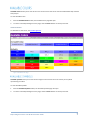
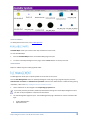
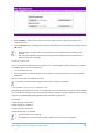
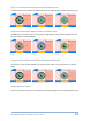
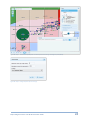
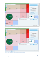
Figure 40. Step 1 - The MI Viewer (MING) after an initial request and zooming in showing the points (Boats).
Figure 41. Step 2 - Change the point layer zoom range.
Map Intelligence Server Tools & Administration Guide
24


![ArcMap [v10.0- v.10.2] User manual](http://vs1.manualzilla.com/store/data/005724954_1-1f5d2da94c774511c91b8b97dbbbcd93-150x150.png)
![Intergraph Geomedia [6.1-2013] User manual](http://vs1.manualzilla.com/store/data/005689587_1-58c82d14f3ba8ebe92b5c45af00d079c-150x150.png)