1
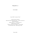
PARFIT-2.1
A tool for the parametrization of volcanic ash deposits
G. Macedonio(1), A. Costa(2)
(1)
Istituto Nazionale di Geofisica e Vulcanologia, Osservatorio Vesuviano, Napoli, Italy
(2)
Istituto Nazionale di Geofisica e Vulcanologia (INGV)
Via Donato Creti 12 - 40128 Bologna, Italy
February 2014
PARFIT 2.1 USER MANUAL
2
parfit code Copyright (C) 2014 Giovanni Macedonio, Antonio Costa.
This program is free software: you can redistribute it and/or modify it under the terms of the GNU
General Public License as published by the Free Software Foundation, either version 3 of the License, or
(at your option) any later version.
This program is distributed in the hope that it will be useful, but WITHOUT ANY WARRANTY;
without even the implied warranty of MERCHANTABILITY or FITNESS FOR A PARTICULAR PURPOSE. See the GNU General Public License for more details.
You should have received a copy of the GNU General Public License along with this program. If not,
visit http://www.gnu.org/licenses/
3
PARFIT 2.1 USER MANUAL
Contents
1 Introduction
4
2 Description of parfit
2.1 How parfit works . . . . . . . . . . . . . . . . . . . . . . . . . . . . . . . . . . . . . . . .
4
4
3 Input files
3.1 The input file parfit.inp . . . . . . .
3.1.1 Block wind . . . . . . . . . . .
3.1.2 Block turbulence . . . . . .
3.1.3 Block column . . . . . . . . .
3.1.4 Block vent . . . . . . . . . . .
3.1.5 Block flags . . . . . . . . . .
3.2 The input file ground thickness.inp
3.3 The input file column spectrum.inp .
3.4 The input file ground spectra.inp . .
3.5 The optional input file wind.dat . . .
.
.
.
.
.
.
.
.
.
.
.
.
.
.
.
.
.
.
.
.
.
.
.
.
.
.
.
.
.
.
.
.
.
.
.
.
.
.
.
.
.
.
.
.
.
.
.
.
.
.
.
.
.
.
.
.
.
.
.
.
.
.
.
.
.
.
.
.
.
.
.
.
.
.
.
.
.
.
.
.
.
.
.
.
.
.
.
.
.
.
.
.
.
.
.
.
.
.
.
.
.
.
.
.
.
.
.
.
.
.
.
.
.
.
.
.
.
.
.
.
.
.
.
.
.
.
.
.
.
.
.
.
.
.
.
.
.
.
.
.
.
.
.
.
.
.
.
.
.
.
.
.
.
.
.
.
.
.
.
.
.
.
.
.
.
.
.
.
.
.
.
.
.
.
.
.
.
.
.
.
.
.
.
.
.
.
.
.
.
.
.
.
.
.
.
.
.
.
.
.
.
.
.
.
.
.
.
.
.
.
.
.
.
.
.
.
.
.
.
.
.
.
.
.
.
.
.
.
.
.
.
.
.
.
.
.
.
.
.
.
.
.
.
.
.
.
.
.
.
.
.
.
.
.
.
.
.
.
.
.
.
.
.
.
.
.
.
.
.
.
.
.
.
.
.
.
.
.
.
.
.
.
.
.
.
.
.
.
.
.
6
6
6
7
8
8
9
10
10
10
10
4 Output files
4.1 The output
4.2 The output
4.3 The output
4.4 The output
.
.
.
.
.
.
.
.
.
.
.
.
.
.
.
.
.
.
.
.
.
.
.
.
.
.
.
.
.
.
.
.
.
.
.
.
.
.
.
.
.
.
.
.
.
.
.
.
.
.
.
.
.
.
.
.
.
.
.
.
.
.
.
.
.
.
.
.
.
.
.
.
.
.
.
.
.
.
.
.
.
.
.
.
.
.
.
.
.
.
.
.
.
.
.
.
.
.
.
.
.
.
.
.
.
.
.
.
.
.
.
.
.
.
.
.
11
11
11
11
11
5 Compiling and installing parfit
5.1 Floating Point precision . . . . . . . . . . . . . . . . . . . . . . . . . . . . . . . . . . . . .
5.2 The Suzuki model . . . . . . . . . . . . . . . . . . . . . . . . . . . . . . . . . . . . . . . .
11
12
12
6 NOTE
12
file
file
file
file
parfit.out
chi2.out .
parfit.wnd
parfit.cmp
.
.
.
.
.
.
.
.
.
.
.
.
.
.
.
.
.
.
.
.
.
.
.
.
List of Figures
1
Wind profile generated by parfit. . . . . . . . . . . . . . . . . . . . . . . . . . . . . . . .
7
List of Tables
1
2
3
4
5
6
Sample
Sample
Sample
Sample
Sample
Sample
of
of
of
of
of
of
file
file
file
file
file
file
parfit.inp . . . . . . .
ground thickness.inp
column spectrum.inp .
ground spectra.inp . .
winds.dat . . . . . . . .
parfit.out . . . . . . .
.
.
.
.
.
.
.
.
.
.
.
.
.
.
.
.
.
.
.
.
.
.
.
.
.
.
.
.
.
.
.
.
.
.
.
.
.
.
.
.
.
.
.
.
.
.
.
.
.
.
.
.
.
.
.
.
.
.
.
.
.
.
.
.
.
.
.
.
.
.
.
.
.
.
.
.
.
.
.
.
.
.
.
.
.
.
.
.
.
.
.
.
.
.
.
.
.
.
.
.
.
.
.
.
.
.
.
.
.
.
.
.
.
.
.
.
.
.
.
.
.
.
.
.
.
.
.
.
.
.
.
.
.
.
.
.
.
.
.
.
.
.
.
.
.
.
.
.
.
.
.
.
.
.
.
.
.
.
.
.
.
.
.
.
.
.
.
.
.
.
.
.
.
.
14
15
15
16
17
18
4
PARFIT 2.1 USER MANUAL
1
Introduction
A common problem in volcanology is the description of the volcanic column and the ash transport
mechanisms starting from the deposit generated by the eruption itself. Different models are available
for solving the direct problem, that is to estimate the ash fall deposit starting from the total erupted
mass, grain size distribution of the particles, wind field, atmospheric conditions, volcanic column height
and shape (eg: FALL3D, HAZMAP, TEPHRA, etc.), however few methods are available for solving the
inverse problem (eg: Pyle, 1989; Bonadonna et al., 1998). parfit belongs to the category of the solvers
of this inverse problem, whose aim is to find the set of input parameters that minimize the difference
between the simulated and the real deposits. parfit was designed for searching the best parameters
(total mass, column height, the bulk granulometry, the mass distribution inside the column, wind profile
and atmospheric diffusion coefficient), required by the computer code hazmap, for reconstructing the
observed tephra deposits and granulometry spectra. However, the obtained results can be used also as
input to other models. parfit was applied for the reconstruction of ash fall deposits the Plinian eruption
of Vesuvius occurred in A.D. 472 (Bonasia et al., 2010).
2
Description of parfit
parfit is a fortran code able to find the volcanic eruption parameters, starting from field data. On
UNIX/Linux machines, parfit is executed by invoking the command parfit from the shell prompt. The
code reads the control file (parfit.inp) where the user defines the domain of investigation of the eruption
parameters and other computational flags (see Sec. 3.1), then it loads the thickness of the ground deposit
measured in different stratigraphic sections (file ground thickness.inp), and performs a search on grid
for finding the best parameters that fit the deposit using the model hazmap (Macedonio et al., 2005;
Pfeiffer et al., 2005). If the bulk grain size distribution (ie: the grain size distribution in the eruption
column) is known, it may be specified in the optional input file column spectrum.inp. Alternatively, the
bulk grain size distribution is estimated by parfit starting from the size distributions at ground, defined
in file ground spectra.inp. Results are printed on the screen and in file parfit.out).
2.1
How parfit works
Input parameters required by Hazmap for reconstructing an ash fallout deposit produced by an explosive
volcanic eruption can be obtained solving an inverse problem.
Fitting is performed using a least-squares method which compares measured and calculated deposits
thickness and grain-sizes. Because of the inherent limitation of the model to medium-range and distal
parts of a deposit, only available data at a distance of at least few km from the eruption vent are
considered.
The function to be minimised (e.g Pfeiffer et al., 2005; Costa et al., 2009) is:
N
1 X
wi [Yobs,i − Ymod,i ]2
χ =
N − p i=1
2
(1)
where wi are weighting factors, N is the number of observed data, p is the number of free parameters,
Yobs,i denote the observed ground load (kg/m2 ) and Ymod,i the values predicted by the model. The choice
of the weighting factors, wi , depends upon the distribution of the errors (Costa et al., 2009).
In order to well constrain the input parameters, it is necessary to know thickness and grain-size values
in a large number, N , of stratigraphic sections, such as N ≫ p. For example, Pfeiffer and Costa (2004)
showed that a good reliable inversion is given by at least 40-50 well distributed stratigraphic sections
and at least 3-5 sections with individual granulometry and particle component distributions. However,
especially for ancient eruptions, finding enough outcrops with a good exposure is often very arduous.
There is a risk of finding parameters that result physically incorrect, especially when we deal with portions
of the deposit, which represent the tail of the distribution relative to a particle class. In order to avoid
these problems, in the scientific literature, other techniques for the calculation of the particles spectrum, in
terms of the total grain-size distribution, were adopted, allowing the reduction of the degrees of freedom.
5
PARFIT 2.1 USER MANUAL
Parfit-2.0 uses a new procedure which allows for fitting also the bulk grain-size distributions, even when
only few stratigraphic sections are available.
We assume that the best-fitted parameters such as column height, column shape coefficients, wind velocity
and diffusion coefficient, do not vary with the choice of the grain-size classes. Thus, among all the possible
choices, we focus on a restricted number of grain-size classes, for which the inverse problem results
better constrained. In fact, in a first step, the program identifies the area enclosed by the measured
ground sections, that is delimited by a “convex hull”. The calculation of the total mass at the ground
is performed by summing the contribution of each particle type that leads to a Gaussian centre placed
inside the “convex hull” of the measured ground-sections. This procedure allows for estimating the total
mass relative to these classes only. In order to obtain the total mass over a wider range of grain-sizes,
in a second step, we repeat the inversions fixing the values of column height, wind direction, wind speed
and diffusion coefficients, as they were obtained in the previous step, and extend the computation of the
bulk particle spectrum to the particles classes previously neglected, thus, leading to the final estimation
of the effective total mass and of the total bulk velocity class distribution.
The ash load at the ground is given by:
#
"
X M i fj
(x − xGi )2 + (y − yGi )2
(2)
M (x, y) =
2 exp −
2
2πσi,j
2σi,j
i,j
2
where σi,j
is the thickness of the Gaussian relative to the particles that fall from the height zi with
the settling velocity vj . It is related to the settling time and the diffusion coefficient by the relation:
2
σi,j
= 2Kti,j .
The particles settling velocity varies with the height.
In order to take into account the variability of the particles velocity with height, it is defined the coefficient:
b(i, j) =
1
1
dzk
= P
4ti,j
4 k≤i vk,j
(3)
where dzi,j is the thickness of the layer k and vk,j the settling velocity of the particle of the class j into
the layer k.
The ground load is, then, given by:
X Mi fj bi,j
bi,j
2
2
exp −
[(x − xGi ) + (y − yGi ) ]
(4)
M (x, y) =
πK
K
i,j
The mass distribution in real eruption columns is governed by complex physical processes that the model
cannot account for. In order to consider a mushroom-like shape for the column, it is used an empirical
formula modified from the original Suzuki formula (Suzuki, 1983):
n
oλ
z
z
S(x, y, z, t) = S0 (1 − ) exp[A( − 1)]
H
H
× δ(t − t0 )δ(x − x0 )δ(y − y0 )
(5)
where S0 is the normalisation constant, x0 , y0 are the coordinates of the vent, H is the column height
and A and λ are two empirical parameters introduced in Pfeiffer et al. (2005).
The user defines the range and step of the eruption parameters. This defines a multidimensional
grid generated by all the combinations of the parameters. parfit performs a search on the grid for the
minimum χ2 between the simulated deposit simulated and the field data. Simulations are performed
using the hazmap model (embedded in parfit). is based on hazmap, a computer program for simulating the ground deposit generated by the sedimentation of volcanic particles from an explosive eruption
(Macedonio et al., 2005; Pfeiffer et al., 2005).
6
PARFIT 2.1 USER MANUAL
3
Input files
3.1
The input file parfit.inp
File parfit.inp contains information for performing the search of the eruptions parameters and for
controlling the output generated by parfit. This file is structured in blocks following the fortran
namelists, easily readable from fortran codes. These blocks are: wind, turbulence, column,
vent and flags. Each block begins with the directive &block name and ends with a slash “/”, where
block name is the name of the block. The blocks must be written in the same order as specified before
(see also Table 1). Each block contains a list of variables with associated their value. Comments start
with the symbol “!” and are ignored. The name of the variables reflect the same name of the variable
used in the fortran code. A sample of this file is reported in Table 1.
3.1.1
Block wind
This is the first block of file parfit.inp. It begins with the directive &WIND and ends with a slash: “/”
(see also Table 1). In this block, data referring to the generated wind profile are specified. The user may
specify a single wind profile read from a file or specify some parameters used to generate a sequence of
wind profiles for best fitting the deposit data.
• rwindfile
This flag selects weather a wind profile is read from file wind.dat (flag rwindfile = 0) or the
wind profiles are generated using the other parameters defined below (flag rwindfile = 0). The
structure of file wind.dat is specified in Sec. 3.5.
• htropo
This parameter is used when flag rwindfile=0 and specifies the height of the tropopause (in meters).
In parfit, htropo coincides with the height where the wind has its maximum intensity. Fig. 1)
shows the wind profile generated by parfit. According to Cornell et al. (1983), we assume that
the wind speed increases from zero at sea level, up to its maximum at the height of the tropopause
(parameter htropo), then its value is 75% of its maximum value. The wind profile is then multiplied
by the the factor wnd and rotated along the vertical axis, towards direction dir (see (6) and (8)).
• wndmin
This parameter defines the minimum value of the wind intensity at tropopause (in m/s). The
generated wind intensity values start from wndmin and increase by wndstep up to wndmax.
• wndmax
This parameter defines the maximum value of the wind intensity at tropopause (in m/s). The
generated wind intensity values start from wndmin and increase by wndstep up to wndmax. If
wndmin is equal to wndmax, then only one wind intensity is generated.
• wndstep
This parameter defines the increase step of the wind intensity at tropopause (in m/s). The generated
wind intensity values start from wndmin and increase by wndstep up to wndmax. The value of
wndstep should be equal to the difference (wndmax - wndmin) divided by an integer number (the
number of steps -1). The generated sequence of wind intensities at tropopause (wnd) is:
wndi = wndmin + i ∗ wndstep
(i = 0, ..., nwnd)
where nwnd is the number of generated wind directions:
wndmax − wndmin
nwnd = NINT
wndstep
and NINT represents the nearest integer.
(6)
(7)
7
PARFIT 2.1 USER MANUAL
• dirmin
This parameter defines the minimum value of the wind direction at tropopause (in degrees east).
The generated wind direction values start from dirmin and increase by dirstep up to dirmax.
The wind direction is the direction towards the wind blows; it starts from East (direction=0) and
increases counter-clockwise (eg: a wind blowing from South has direction=90, and a wind from
East has direction=180).
• dirmax
This parameter defines the maximum value of the wind direction at tropopause (in degrees east).
The generated wind direction values start from dirmin and increase by dirstep up to dirmax. If
dirmin is equal to dirmax, then only one wind direction is generated.
• dirstep
This parameter defines the increase step of the wind direction at tropopause (in degrees). The
generated wind direction values start from dirmin and increase by dirstep up to dirmax. The
value of dirstep should be equal to the difference (dirmax - dirmin) divided by an integer number
(the number of steps -1). The generated sequence of wind directions (dir) is:
diri = dirmin + i ∗ dirstep
(i = 0, ..., ndir)
(8)
where ndir is the number of generated wind directions:
dirmax − dirmin
ndir = NINT
dirstep
(9)
and NINT represents the nearest integer.
20
Z(km)
15
10
5
0
0.25
0.5
Wind speed (m/s)
0.75
1
Figure 1: Wind profile generated by parfit.
3.1.2
Block turbulence
• cdmin
This parameter defines the minimum value of the atmospheric diffusion coefficient (in m2 /s). The
generated atmospheric diffusion coefficient starts from cdmin and increase by cdstep up to cdmax.
8
PARFIT 2.1 USER MANUAL
The wind direction is the direction towards the wind blows; it starts from East (direction=0) and
increases counter-clockwise (eg: a wind blowing from South has direction=90, and a wind from
East has direction=180).
• cdmax
This parameter defines the maximum value of the atmospheric diffusion coefficient (in m2 /s). The
generated wind direction values start from cdmin and increase by cdstep up to cdmax. If cdmin is
equal to cdmax, then only one wind direction is generated.
• cdstep
This parameter defines the increase step of the atmospheric diffusion coefficient (in m2 /s). The
generated diffusion coefficient start from cdmin and increase by cdstep up to cdmax. The value of
cdstep should be equal to the difference (cdmax - cdmin) divided by an integer number.
The generated sequence of atmospheric diffusion coefficients (cd) is:
cdi = cdmin + i ∗ cdstep
(i = 0, ..., ncd)
where ncd is the number of generated wind directions:
cdmax − cdmin
ncd = NINT
cdstep
(10)
(11)
and NINT represents the nearest integer.
3.1.3
Block column
• hcolmin
This parameter defines the minimum value of the volcanic column height (in meters). The generated
column height start from hcolmin and increase by hcolstep up to hcolmax. The column height is
the height of the top of the column respect to the sea level.
• hcolmax
This parameter defines the maximum value of the volcanic column height (in meters). The generated
column heights start from hcolmin and increase by hcolstep up to hcolmax. If hcolmin is equal
to hcolmax, then only one column height is generated. The column height is the height of the top
of the column respect to the sea level.
• hcolstep
This parameter defines the increase step of the eruptive column height (in meters). The generated
column heights start from hcolmin and increase by hcolstep up to colmax. The value of hcolstep
should be equal to the difference (hcolmax - hcolmin) divided by an integer number.
The generated sequence of volcanic column heights (hcol) is:
hcoli = hcolmin + i ∗ hcolstep
(i = 0, ..., nhcol)
where nhcol is the number of generated column heights:
hcolmax − hcolmin
nhcol = NINT
hcolstep
(12)
(13)
and NINT represents the nearest integer.
3.1.4
Block vent
• xvent
This parameter represents the X coordinate of the vent. Usually it is the East UTM coordinate of
the vent. This parameter is not modified by parfit.
PARFIT 2.1 USER MANUAL
9
• yvent
This parameter represents the Y coordinate of the vent. Usually it is the North UTM coordinate
of the vent. This parameter is not modified by parfit.
• zvent
This parameter represents the elevation of the vent above sea level. The generated column lies
above the vent, between zvent and hcoli (see (12). This parameter is not modified by parfit.
3.1.5
Block flags
• modew
This parameter selects the χ2 weighting factors wi (see (1)):
Flag: modew=0 Constant weighting factor (wi = 1).
2
Flag: modew=1 Proportional weighting factor (wi = 1/Yobs
).
Flag: modew=2 Statistical weighting factor (wi = 1/Yobs ).
• iflch
This flag selects whether the maxima of the sub-deposits generated by each grain size class must
lie in the convex hull (0=NO, 1=YES).
• ifenl
This flags allows the enlargement of the convex hull by the amount specified by parameter belthull
(0=NO,1=YES). It has effect if iflch=1.
• belthull
This parameter specifies how much enlarge the convex hull, in meters. It has effect if both iflch=1
and ifenl=1.
• iflwgt
In case some ground sections do not have associated a particle grain size distribution, this flag
allows the use of the grain size distrubution form the nearest point where it is available (0=NO,
1=YES).
• vmodel
This flag selects the settling velocity model:
Flag: vmodel=1 Model of Arastoopour et al. (1982).
Flag: vmodel=2 Model of Ganser (1993).
Flag: vmodel=3 Model of Wilson and Huang (1979).
Flag: vmodel=4 Model of Dellino et al. (2005).
• ifvofz
This flag selects whether the settling velocity is allowed to vary with the altitude:
Flag: ifvofz=0 The settling velocity is evaluated at sea level and is assumed constant with
height.
Flag: ifvofz=1 The settling velocity is allowed to vary with the altitude, assuming that the
variations of the density and viscosity of the atmosphere follow the International Standard
Atmosphere (Smithsonian Institution, 1951).
• ifchi
This flag specifies whether the list of evaluated Ξ2 is printed in file chi2.out (0=NO, 1=YES).
• ifgsp
This file selects the method for handling the bulk grain size distribution in the column:
ifgsp=0 - The whole grain size distribution in the column is read from file column spectrum.inp.
PARFIT 2.1 USER MANUAL
10
ifgsp=1 - The grain size distribution in the column is estimated from best fitting the grain
size distributions in the deposit sections, defined in file ground spectra.inp.
3.2
The input file ground thickness.inp
This file defines the deposit sections:
• The first record defines the number of ground sections specified below (variable npts).
• npts records, each corresponding to a different ground section. Each record has the following fields:
label of the section, X and Y UTM coordinates of the section, thickness of the deposit (metres),
density of the deposit.
A sample of file ground thickness.inp is reported in Table 2.
3.3
The input file column spectrum.inp
This file is used if the bulk grain size distribution of the eruption column is known (flag ifgsp=0). This
is equivalent to the bulk grain size distribution of the deposit.
• The first record defines the number of particles classes (variable ntypes).
• The following ntypes records refer to each particle class. Each record has four fields: diameter
of the particle (metres), density of the particle (kg/m3 ), particle shape factor (adimensional, for
spheres = 1), quantity of the particles (weight %).
A sample of file column spectrum.inp is reported in Table 3.
3.4
The input file ground spectra.inp
This file is used if the grain size distribution of the particles is specified in the deposit sections (flag
ifgsp=1).
• The first record defines the number of particles types (variable ntypes).
• The following ntypes records refer to each particle type. Each record has three fields: diameter
of the particle (metres), density of the particle (kg/m3 ), particle shape factor (adimensional, for
spheres = 1).
• Number of ground sections where the the particle type distribution is specified (variable nsect).
• A number of block equal to nsect follows. Each block has the following structure:
– Label of the section (corresponding to the same label defined in file ground thickness.inp).
– List of ntypes records, each containing the mass fraction of the corresponding particle type
in the section. These are specified in the same order as specified above.
A sample of file ground spectra.inp is reported in Table 4.
3.5
The optional input file wind.dat
The format of this file is the same as that used by hazmap.
• Number of Z-layers (NZ).
• A list of NZ records, each specifying the height of the Z-layer above sea level (in metres).
• A list of NZ records, each corresponding to a different Z-layer. Each record has 6 fields: year, month,
day, number of Z-layer, Vx, Vy. Where Vx and Vy are the components of the wind in the Z-layer
toward X (East) and Y (North)
A sample of file winds.dat is shown in Table 5.
PARFIT 2.1 USER MANUAL
4
4.1
11
Output files
The output file parfit.out
File parfit.out contains the results of parfit, that is the parameters that minimize the discrepance
between the simulated deposit and the field observation (minimum χ2 ).
A sample of file parfit.out is reported in Table 6.
4.2
The output file chi2.out
File chi2.out is generated when flag ifchi=1 in the input file parfit.inp. Thi file contains the complete
list of χ2 scanned by parfit during the search of its minimum. This file has a number of records equal to
the total combinations of parameters generated by parfit. Each record has the following 9 fields: Suzuki
parameter A, Suzuki parameter λ, column height, wind intensity, wind direction, diffusion coefficient,
beta, χ2 , number of particles types whose deposit has its baricenter inside the convex hull (variable
nctypes). If flag iflch=0 (ignore the convex hull), then nctypes=ntypes.
4.3
The output file parfit.wnd
File parfit.wnd contains the best wind found after minimizing the χ2 . It has the same structure of the
input file winds.dat (see Sec. 3.5). However, the date of the wind is set to day=0, month=0, year=0.
If the the input wind file is used (flag rwindfile=1), then parfit.wnd becomes a duplicate of file
winds.dat.
4.4
5
The output file parfit.cmp
Compiling and installing parfit
parfit version 2.1 is written in fortran-90. To install parfit, uncompress and unpack the tar file
parfit-2.1.tar.gz, then go to the parfit-2.1/src directory.
gunzip parfit-2.1.tar.gz
tar -xf parfit-2.1.tar
cd parfit-2.4/src
Now you should select the fortran compiler: edit the Makefile and set the variable FC must to the
proper compiler. For example:
#
FC=ifort
FCFLAGS=
c
fortran compiler ifort is specified. Another choice could be the gfortran
In this case the Intel
compiler:
#
FC=gfortran
FCFLAGS=
Additional compilation flags can specified by the variable FCFLAGS. For example, to activate the optimizer
of the ifort compiler (flag -O) insert:
#
FC=ifort
FCFLAGS= -O
Now you are ready to compile parfit: just issue the command:
make
PARFIT 2.1 USER MANUAL
12
This generates the binary files parfit. By default, the executable is installed in the directory src. To
check the installation, change directory to example under the directory parfit-2.1, and run ../src/parfit.
The executable binary file parfit may be moved in your preferred PATH. Moreover, the input files
parfit.inp, ground thickness.inp, ground spectra.inp and the optional file wind.dat can be modified to be adapted to the user.
5.1
Floating Point precision
parfit-2.1 allows the complilation of subroutines and functions either assuming that floating point reals
ar single or double precision. To switch between these, edit file src/kindtype.f90 and set the integer
parameter SP as SINGLE or DOUBLE. Then issue the command make.
5.2
The Suzuki model
parfit may be compiled using the standard Suzuki model (subroutine suzuki.f90), or its integrated version (subroutine isuzuki.f90 + function igamma.f90). To switch between the two versions uncomment
the corresponding list of linked object(s) in file src/Makefile (parameter SUZUKIMODEL).
6
NOTE
parfit-2.1 uses the following public domain routines:
• To define the properties of the U.S. Standard Atmosphere 1977, parfituses subroutine atmosphere written by Ralph Carmichael, Public Domain Aeronautical Software, 2009 (freely available
at http:///www.pdas.com).
• To define the convex hull of the sampled ground points, parfit uses algorithm 523 by W.F. Eddy,
ACM TOMS 3 (1977) 411-412, available at URL http://www.netlib.org (TOMS, algorithm 523).
Here, algorithm 523 was translated in F90 and is contained into subroutines convex.f90 and
split.f90.
Acknowledgments
We thank R. Bonasia for testing the code and suggestions that greatly improved the code. This work was
partially supported by the Italian Department of Civil Protection (INGV-DPC Agreement 2007-2009,
Project V5 - “SPeeD”).
References
Arastoopour, H., Lin, S., Weil, S., 1982. Analysis of vertical pneumatic conveying of solids using multiphase flow models. AIChE J. 28, 467–473.
Bonadonna, C., Ernst, G., Sparks, R., 1998. Thickness variations and volume estimates of tephra fall
deposits: the importance of particle Reynolds number. J. Volcanol. Geotherm. Res. 81, 173–187.
Bonasia, R., Macedonio, G., Costa, A., Mele, D., Sulpizio, R., 2010. Numerical inversion and analysis of
tephra fallout deposits from the 472 AD sub-Plinian eruption at vesuvius (Italy) through a new best-fit
procedure. J. Volcanol. Geotherm. Res. 189, 238–246.
Cornell, W., Carey, S., Sigurdsson, H., 1983. Computer simulation and transport of the Campanian Y-5
ash. J. Volcanol. Geotherm. Res. 17, 89–109.
Costa, A., Dell’Erba, F., Di Vito, M., Isaia, R., Macedonio, G., Orsi, G., Pfeiffer, T., Apr. 2009. Tephra
fallout hazard assessment at the campi flegrei caldera (italy). Bull. Volcanol. 71 (3), 259–273.
PARFIT 2.1 USER MANUAL
13
Dellino, P., Mele, D., Bonasia, R., Braia, L., La Volpe, R., 2005. The analysis of the influence of pumice
shape on its terminal velocity. Geophys. Res. Lett. 32 (L21306).
Ganser, G., 1993. A rational approach to drag prediction of spherical and nonspherical particles. Powder
Technol. 77, 143–152.
Macedonio, G., Costa, A., Longo, A., 2005. A computer model for volcanic ash fallout and assessment of
subsequent hazard. Comput. Geosci. 31, 837–845.
Pfeiffer, T., Costa, A., 2004. A numerical reconstruction of fall deposits from Agnano-Montespina (4100
BP) Plinian eruption in the Campi Flegrei area. Tech. Rep. OV Prot. N. 4440 (10.11.2004), Osservatorio
Vesuviano-INGV, http://www.earth-prints.org/handle/2122/2068.
Pfeiffer, T., Costa, A., Macedonio, G., 2005. A model for the numerical simulation of tephra fall deposits.
J. Volcanol. Geotherm. Res. 140, 273–294.
Pyle, D., 1989. The thickness, volume and grainsize of tephra fall deposits. Bull. Volcanol. 51, 1–15.
Smithsonian Institution, 1951. Smithsonian meteorological tables, 6th edition. Washington, D.C.
Suzuki, T., 1983. A theoretical model for dispersion of tephra. In: Shimozuru, D., Yokoyama, I. (Eds.),
Arc Volcanism: Physics and Tectonics. Terra Scientific Publishing Company (TERRAPUB), Tokyo,
pp. 93–113.
Wilson, L., Huang, T., 1979. The influence of shape on the atmospheric settling velocity of volcanic ash
particles. Earth Planet. Sci. Lett. 44, 311–324.
14
PARFIT 2.1 USER MANUAL
Table 1: Sample of file parfit.inp
!
! EXAMPLE OF FILE parfit.inp (Version 2.1)
!
&WIND
! OPEN WIND BLOCK
rwindfile = 1
! Read file wind.dat [0=NO, 1=YES]
htropo = 11000.
! Height of the tropopause (m)
wndmin = 40.
! Min wind intensity (m/s)
wndmax = 45.
! Max wind intensity (m/s)
wndstep= 5.
! Step of the wind intensity (m/s)
dirmin = 24.
! Min wind direction (degrees)
dirmax = 26.
! Max wind direction (degrees)
dirstep= 2.
! Step of wind direction (degrees)
/
! CLOSE WIND BLOCK
!
&TURBULENCE
! OPEN TURBULENCE BLOCK
cdmin = 4000.
! Horizontal diffusion coefficient
cdmax = 4000.
cdstep = 500.
/
! CLOSE TURBULENCE BLOCK
!
&COLUMN
! OPEN COLUMN BLOCK
hcolmin = 20000.
! Min column height
hcolmax = 20000.
! Max column height
hcolstep = 500.
! Column height step
suz1min = 4.
! Suzuki coefficient N.1 (A)
suz1max = 4.
suz1step = 0.5
suz2min = 1.
! Suzuki coefficient N.2 (Lambda)
suz2max = 1.
suz2step = 0.5
/
! CLOSE COLUMN BLOCK
!
&VENT
! VENT BLOCK
xvent = 451737.
! Coordinates of the vent
yvent = 4519302.
zvent = 0.
! Elevation of the vent above sea level
/
! CLOSE VENT BLOCK
!
&FLAGS
! FLAGS BLOCK
modew = 0
! Chi2 weighting mode [0-2]
iflch = 1
! Check if gauss maxima are in convex hull [0-1]
!
ifenl = 0
! Enlarge the convex hull [0=NO,1=YES]
belthull= 1000.
! How much enlarge the convex hull (m)
!
iflwgt = 1
! Use nearest points for spectra
vmodel = 1
! Settling velocity model
ifvofz = 1
! Flag: Vsettl. is a function of Z
ifchi = 0
! Write file chi2.out (0=NO, 1=YES)
ifgsp = 1
! Use file column_spectrum.inp/ground_spectra.inp
/
! CLOSE FLAGS BLOCK
15
PARFIT 2.1 USER MANUAL
Table 2: Sample of file ground thickness.inp
14
A01
A02
A03
A04
A05
A06
A07
A08
A09
A10
A11
A12
A13
A14
455906.
461855.
459513.
459015.
457470.
469247.
465646.
471913.
460309.
461577.
480443.
475851.
478215.
464973.
4525476.
4521650.
4521538.
4516330.
4516554.
4531112.
4526071.
4524904.
4521504.
4522298.
4528885.
4526648.
4526671.
4532304.
0.199
0.652
0.764
0.085
0.115
0.194
0.508
0.317
0.739
0.737
0.186
0.253
0.194
0.066
1000.
1000.
1000.
1000.
1000.
1000.
1000.
1000.
1000.
1000.
1000.
1000.
1000.
1000.
Table 3: Sample of file column spectrum.inp
10
3.900e-6
7.800e-6
15.62e-6
31.25e-6
62.50e-6
125.0e-6
250.0e-6
500.0e-6
1.000e-3
2.000e-3
1400
1400
1400
1400
1400
1700
1700
2500
2500
2500
1.0
1.0
1.0
1.0
1.0
1.0
1.0
1.0
1.0
1.0
6.17
9.26
10.49
12.35
16.67
12.35
11.11
6.17
6.79
8.64
#
#
#
#
#
#
#
#
#
#
#
NTYPES (number of particle types listed below)
Diameter(m), density, shape, wt%
Diameter(m), density, shape, wt%
Diameter(m), density, shape, wt%
Diameter(m), density, shape, wt%
Diameter(m), density, shape, wt%
Diameter(m), density, shape, wt%
Diameter(m), density, shape, wt%
Diameter(m), density, shape, wt%
Diameter(m), density, shape, wt%
Diameter(m), density, shape, wt%
16
PARFIT 2.1 USER MANUAL
Table 4: Sample of file ground spectra.inp
10
3.900e-6
7.800e-6
15.62e-6
31.25e-6
62.50e-6
125.0e-6
250.0e-6
500.0e-6
1.000e-3
2.000e-3
2
A02
0.0614
0.0712
0.0379
0.0242
0.0512
0.0702
0.1254
0.1462
0.1978
0.2146
A13
0.1361
0.1477
0.0844
0.0581
0.4767
0.0953
0.0012
0.0002
0.0002
0.0003
1400
1400
1400
1400
1400
1700
1700
2500
2500
2500
1.0
1.0
1.0
1.0
1.0
1.0
1.0
1.0
1.0
1.0
#
#
#
#
#
#
#
#
#
#
#
#
#
NTYPES
Diameter(m), density, shape
Diameter(m), density, shape
Diameter(m), density, shape
Diameter(m), density, shape
Diameter(m), density, shape
Diameter(m), density, shape
Diameter(m), density, shape
Diameter(m), density, shape
Diameter(m), density, shape
Diameter(m), density, shape
NSECT (number of ground sections)
LABEL Section 1
# LABEL Section 2
17
PARFIT 2.1 USER MANUAL
Table 5: Sample of file winds.dat
40
500.
1000.
1500.
2000.
2500.
3000.
3500.
4000.
4500.
5000.
5500.
6000.
[ ... 26 records deleted ]
19500.
20000.
1986 8 21 1
1.661
0.740
1986 8 21 2
3.322
1.479
1986 8 21 3
4.983
2.219
1986 8 21 4
6.644
2.958
1986 8 21 5
8.305
3.698
1986 8 21 6
9.966
4.437
1986 8 21 7 11.627
5.177
1986 8 21 8 13.288
5.916
1986 8 21 9 14.949
6.656
1986 8 21 10 16.610
7.395
1986 8 21 11 18.271
8.135
1986 8 21 12 19.932
8.874
[ ... 26 records deleted ]
1986 8 21 39 27.406 12.202
1986 8 21 40 27.406 12.202
18
PARFIT 2.1 USER MANUAL
Table 6: Sample of file parfit.out
Parfit version: 2.1
Using wind file: winds.dat
Number of ground sections:
14
Using particles spectra from file: ground_spectra.inp
Number of sections with spectrum:
3
Section: A02
Sum: 1.00010
Section: A13
Sum: 1.00020
Section: A14
Sum: 0.99990
Check for maxima inside convex hull: YES
List of vertices of the convex hull
A14
464973.0 4532304.0
A01
455906.0 4525476.0
A05
457470.0 4516554.0
A04
459015.0 4516330.0
A13
478215.0 4526671.0
A11
480443.0 4528885.0
Number of tests:
1
FLAG:
B
CHI2:
0.99421
TOTMASS: 0.56648E+09
VOL(DRE): 0.21788E-03 (km3)
HCOL:
20000.0
CSUZ1:
4.000
CSUZ2:
1.000
CDIFF:
4000.0
P-TYPE
wt%
Vset (at sea level)
9
52.563
6.7938
10
47.437
11.013
SUM: 100.000
WARNING: Min. chi2 lies on parameters borders
BDRY: CSUZ1
4.00000000000000
BDRY: CSUZ2
1.00000000000000
BDRY: COLUMN HEIGHT
20000.0000000000
BDRY: DIFF. COEFF.
4000.00000000000
PT Vset(sealev)
X_mass
Y_mass
Distance
OUT 1
0.64772E-03 291694979.4 134189328.5 318805492.5
OUT 2
0.25877E-02 73322233.5 36963382.6 79766707.5
OUT 3
0.10324E-01 18684857.3 12637221.6 19958639.5
OUT 4
0.40473E-01
5071057.4
6575958.9
5056476.8
OUT 5
0.14985
1670156.4
5061778.1
1333726.4
OUT 6
0.56111
757398.7
4655391.6
334588.4
OUT 7
1.3913
566784.6
4570524.6
125935.4
OUT 8
3.6853
492991.9
4537669.9
45159.2
IN
9
6.7938
473674.9
4529069.4
24014.0
IN 10
11.013
464440.6
4524958.0
13905.8