1
Ag Data Mapping Solution - ADMS User Manual
241
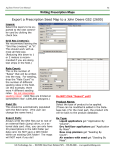
Landsat Data Processing—Cutting Images By Shape File
The extractor utility
will cut an image
out for each county
that the Landsat
scene covers and
then creates and
places them in a
folder structure.
When all the files are
finished being processed, ―Process
Complete‖ will be
displayed at the bottom of the window.
A file structure will appear in the directory
that the output image folder was pointed at.
Inside each of the counties will have a folder
containing the extracted Landsat tiff images.
Additional Notes:
If only certain areas need to be processed,
the function ―Create Only Selected Items‖ can
be used.
To utilize this function, the polygon(s) must
first be selected before the Tif Extractor is
opened.
1. With the polygon as the
active layer, use the selection tools on the top toolbar.
2. Select the polygons to be extracted.
3. Open the Tif Extractor
4. Follow the process above and put a check
in ―Create Only Selected Items.‖
GK Technology, Inc. - 204 Fifth Street East, Halstad, MN - 855-458-3244 - www.gktechinc.com