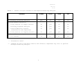
1
Santa Barbara County
Air Pollution Control District
MODELING GUIDELINES FOR
AIR QUALITY IMPACT ANALYSIS
Santa Barbara County
Air Pollution Control District
MODELING GUIDELINES FOR
AIR QUALITY IMPACT ANALYSIS
June, 1996
MODELING GUIDELINES FOR
AIR QUALITY IMPACT ANALYSIS
SANTA BARBARA COUNTY
AIR POLLUTION CONTROL DISTRICT
26 Castilian Drive, B-23
Goleta, California 93117
(805) 961-8800
June, 1996
TABLE OF CONTENTS
Abbreviations and Acronyms
iii
OVERVIEW
1
I.
A.
B.
C.
D.
E.
Introduction
General Procedures
Source Parameters
Models
Source of Models
Submittals to the District
2
2
2
3
4
6
II.
A.
B.
C.
Screening Analysis
General Information
SCREEN
Averaging Time Conversions
6
6
6
8
III. Modeling Point Sources with ISCST
A.
General Information
B.
Point Sources in Simple, Intermediate, or Complex
Terrain
C.
Building Downwash Considerations
9
10
IV.
A.
B.
C.
D.
E.
Modeling Onshore Point Sources with RTDM
General Information
Model Inputs
RTDM Options
Running RTDM
Postprocessor Analysis
12
13
13
14
17
18
V.
A.
B.
C.
D.
E.
Modeling Onshore Non-Point Sources with ISCST
General Information
ISCST Options
ISCST Modeling of Volume, Line and Area Source Types
Scheduling and Averaging Period Considerations
Meteorology
19
19
20
20
25
27
VI.
Modeling Offshore and Associated Coastal Source
Emissions
General Information
OCD Model Input Requirements
Point Source Description Information
Meteorology
Shoreline Geometry
27
27
29
29
32
39
A.
B.
C.
D.
E.
9
9
VII. Fumigation Modeling
39
VIII. Background Air Quality/Ozone-Limiting Method
A.
Use of Background Air Quality for Pollutants Other Than
NO
40
40
1
B.
Use of Background Air Quality for NO
41
IX.
A.
B.
Receptor Grid Spacing
General Requirements
Model Specific Requirements
42
42
42
X.
Modeling of Emission Reduction Credits (Offsets)
44
XI.
References
45
LIST OF TABLES
TABLE 1. Generic Project Scenarios and Required Modeling
Analyses
5
TABLE 2.
Meteorological Data Format
12
TABLE 3.
Main Model Options for OCD Simulations
30
TABLE 4. Typical Surface Roughness Lengths for Various
Ground Covers
TABLE 5. Additional Meteorological Data Options for OCD
Simulations
31
TABLE 6. Reasonable Worst-Case Meteorological Data Set for
OCD Simulations
38
TABLE 7. Factors to Convert One-Hour Modeled Concentrations
to Longer Averaging Periods
39
2
37
Abbreviations and Acronyms
AQIA
Air Quality Impact Analysis
ATC
Authority To Construct
BPI
Bits per inch
CAAQS
California Ambient Air Quality Standard
CARB
California Air Resources Board
COMPLEX-I
Complex Terrain Model for Point Sources
District
Santa Barbara County Air Pollution Control
District
EPA
Environmental Protection Agency
g/s
Grams per Second
GEP
Good Engineering Practice
ISCST
Industrial Source Complex -- Short Term Model
0
K
Degrees Kelvin
m
Meters
m/s
Meters Per Second
MMS
Minerals Management Service
MPTER
Multiple Point Guassian Dispersion Algorithm with
Optional Terrain Adjustment
NTIS
National Technical Information Service
NSR
New Source Review
OCD
Offshore and Coastal Dispersion Model
OCS
Outer Continental Shelf
ppm
Parts Per Million
PTFUM
A Single Source Fumigation Model
PSD
Prevention of Significant Deterioration
ROW
Right of Way
RTDM
Rough Terrain Dispersion Model
SCREEN
Screening Procedures for Stationary Sources
UNAMAP
User's Network for Applied Modeling of Air
Pollution
3
AQIAGDLS.WP5
JUNE, 1996
Rev #2
OVERVIEW
This document presents the current Santa Barbara County Air
Pollution Control District (District) guidance on the use of air
dispersion modeling to assess the air quality impacts of
stationary sources. The document represents an update and
revision to the October 20, 1987 version of Chapter 6 (Air
Quality Impact Analysis) from the Authority to Construct (ATC)
Permit Processing Manual. In addition to the technical
revisions, the guidelines have been brought under a separate,
stand-alone, cover.
An Air Quality Impact Analysis (AQIA) is required when applicable
emissions thresholds specified in District rules are exceeded.
These emission trigger levels are specified in District Rules and
Regulations (i.e., New Source Review) for both attainment and
nonattainment pollutants. Depending upon the pollutants to be
assessed, an AQIA may be required to evaluate compliance with
ambient air quality standards, increment consumption, or both.
For the evaluation of ambient air quality standards, existing
California and National standards are the established criteria.
These analyses must consider the background air quality levels in
conjunction with project emissions. An increment consumption
analysis is only applicable to attainment pollutants for which
allowable increment levels have been established to limit the
amount of air quality degradation in an attainment area. All
increment consuming sources must be included in an increment
analysis.
Air dispersion models generally simulate two types of pollutants,
inert and reactive. Inert pollutants are commonly modeled using
Gaussian assumptions while reactive (photochemical) pollutants
are simulated with Lagrangian or Eulerian schemes. This document
only addresses inert pollutant modeling. Guidance on reactive
pollutant modeling can be obtained from the California Air
Resources Board (CARB) document entitled "Technical Guidance
Document: Photochemical Modeling (CARB, 1990)."
Section I presents an introduction to some general aspects of the
Districts modeling requirements including discussions on the
procedures to be followed while performing an AQIA, what models
are to be used in the analysis, where to obtain the models, and
what is required in a submittal to the District for review and
approval. Sections II through VI discuss specific model
requirements for SCREEN, ISCST, RTDM, and OCD. Section VII,
Fumigation; Section VIII outlines the proper use of background
air quality values and the ozone-limiting method. Sections VIX
and X discuss the proper placement of receptors and the use of
offsets in the AQIA, respectively. References are provided in
Section XI.
1
AQIAGDLS.WP5
JUNE, 1996
Rev #2
I.
Introduction
A.
General Procedures
An inert pollutant modeling assessment will normally involve a
two-phased approach. The first phase of the assessment is to
apply a simple screening procedure to determine if either:
-
The source clearly poses no air quality problem, or
-
The potential for an air quality problem exists.
If the screening procedures indicate that there may be a
potential air quality problem, a refined analysis must be
undertaken. Both screening and refined analyses are discussed in
this document.
All emissions from the stationary source being analyzed are to be
included in the AQIA. This includes facilities in the Outer
Continental Shelf (OCS) and outside of Santa Barbara County which
have the potential to impact Santa Barbara County air quality,
and all facilities within the jurisdiction of the District. In
addition, the AQIA may be expanded if project conditions placed
on the applicant by other regulatory agencies direct that other
scenarios be examined by the District. Examples of additional
issues for which analysis may be required include, but may not be
limited to:
-
Air quality impacts from consolidated facilities.
-
Cumulative air quality impacts from proposed project and all
reasonably foreseeable projects.
-
Air quality impacts from construction emissions.
-
Future specific throughput rates or levels of production not
applied for by the applicant.
Air quality modeling is extremely source-specific. Complex
source configurations may require extensive modeling procedures
which would not be needed to assess a simple source. Because of
this, the District recommends that a modeling protocol be
submitted for all projects prior to executing the models. The
protocol must contain all relevant modeling information including
the specific model to be executed, program control data, source
parameters, receptor data, and meteorological data. All
procedures must be clearly described so that District staff can
approve the methodology being proposed. This protocol process
saves both time and money if used correctly.
B.
Source Parameters
2
AQIAGDLS.WP5
JUNE, 1996
Rev #2
For each source of pollutants modeled, the following inputs are
required:
-
source coordinates (UTM)
-
pollutant emission rate (g/s)
-
stack height (m)
-
stack gas exit temperature (0K)
-
stack gas exit velocity (m/s)
-
source elevation (m)
Emission rates used as input to the models for a proposed source
must be the applicable emission increases from the stationary
source. All emission increases from the source which have
occurred or will occur after the preconstruction monitoring data
are collected must be included. Additionally, emissions from
other permitted sources which were not operating at permitted
capacity at the time of preconstruction monitoring must be
included in the modeling.
Maximum hourly emission rates are to be used for modeling
averaging periods less than or equal to 24 hours. Annual average
emission rates are to be used for annual average concentration
calculations. All of these parameters must be reviewed by
District engineering staff prior to executing the model.
C.
Models
For inert pollutant modeling, the models which are to be
implemented are as follows:
SCREEN: For all inert pollutant screening analyses.
ISCST: For modeling inert pollutant impacts from all
point sources which impact terrain with elevation
less than the height of the lowest stack height.
ISCST must also be used to model inert pollutant
impacts from onshore non-point emission sources
(e.g., area, volume, and line sources).
RTDM:
For modeling inert pollutant impacts from all
onshore point sources which impact terrain with
elevation equal to or greater than the height of the
lowest stack height.
3
AQIAGDLS.WP5
JUNE, 1996
Rev #2
OCE:
For modeling inert pollutant impacts from
offshore sources and coastal point sources (up to 1
km from shoreline) associated with offshore sources
of emissions.
Table 1 provides some generic project scenarios and the
associated modeling requirements. Screening analyses can be
performed with SCREEN. For refined analyses, onshore point
sources require the use of either ISCST or RTDM (dependent upon
terrain). An exception to this requirement occurs if the onshore
point source is physically linked to an offshore source (e.g., a
processing plant onshore supplied by an offshore platform).
Depending on the particular circumstances, OCD may be used for
both onshore and offshore sources. It must be noted that the
onshore source in question must be within one kilometer of the
shoreline to be modeled with OCD. All onshore construction
activities will be modeled with ISCST and summed with all
concurrent point source emissions. In addition, fumigation
modeling will be executed for all pollutant sources except
onshore construction activities.
For onshore sources, ISCST will automatically sum the hourly
receptor concentrations from different source types in the same
model run. For cases in which two different models are used
(e.g., OCD for offshore point source, and ISCST for onshore area
source), it may be necessary to use a post-processing routine to
sum together pollutant concentrations for determining the total
air quality impact at receptors.
D.
Source of Models
ISCST, SCREEN, OCD, and RTDM are available from the National
Technical Information Service (NTIS). ISCST is part of a library
of air quality simulation models titled "User's Network for
Applied Models of Air Pollution - Version 6" (UNAMAP 6) (USEPA,
1986). All these models can be directly downloaded from the EPA,
Office of Air Quality Planning and Standards (OAQPS) Technology
Transfer Network (TTN) electronic bulletin board. The telephone
number to call to access the OAQPS TTN is 919-541-5742.
When obtaining an air quality model from somewhere other than the
District, it is imperative that the model be the most up-to-date
version available. Please consult with District staff to assure
that the correct version is being used.
4
AQIAGDLS.WP5
JUNE, 1996
Rev #2
TABLE 1.
Generic Project Scenarios and Required Modeling Analyses
SCENARIO
SCREEN
ISCST
RTDM
OCD
yes
no
no
no
- Point Sources in Simple Terrain
no
yes
no
no
- Building Downwash Analysis
no
yes
no
no
- Area/Volume/Line Sources
no
yes
no
no
no
yes
yes*
no
no
no**
no**
yes
Preliminary Screening Analysis
Refined Onshore Analysis:
(construction and fugitives)
- Point Sources in Complex Terrain
Refined Offshore Analysis:
- All Sources
*
**
Alternative model
Complex projects with both onshore and offshore components may have to perform
multiple modeling analysis
5
AQIAGDLS.WP5
JUNE, 1996
Rev #2
E.
Submittals to the District
Upon completion of the model runs, the applicant must provide the
District on hard-copy and magnetic media (IBM compatible 3.5"
high density diskettes) all material leading to and including the
final output(s). This would include, but not be limited to, all
input files, control files, output files, pre- and post-processor
programs and their input, output and control files, and all
models used. In short, supply all the information needed to
duplicate the work submitted by the applicant.
II.
Screening Analysis
A.
General Information
A screening analysis is intended to provide a conservative
estimate of the impacts from stationary sources to ascertain
whether the potential for an air quality problem exists. The
procedures are intended to be quick and inexpensive. Because of
these factors, there are many limitations to the application of
screening procedures. Highly complex projects (e.g., multiple
stacks, differing source types) can not be assessed using these
simple procedures. If a screening procedure reveals the
potential for an air quality problem, a refined analysis must be
undertaken.
1.
Applicable Source Types
The screening techniques presented in this section apply
primarily to continuous, steady-state releases which are neutral
or positively buoyant. For screening purposes, intermittent
sources should be considered continuous and modeled using the
worst-case 1-hour emission rate. The following list summarizes
the source types for which screening is applicable:
-
onshore point sources in simple or complex terrain
-
onshore point sources with or without building downwash
-
onshore area and volume sources
The procedures in the SCREEN model can estimate concentrations
for each of the above source types. The PTPLU model can only be
used to assess point sources without downwash in simple terrain.
These models are discussed further below.
B.
SCREEN
1.
Model Description
The SCREEN model consists of several simple screening techniques
6
AQIAGDLS.WP5
JUNE, 1996
Rev #2
written into FORTRAN code. The techniques are used to calculate
short-term concentrations for single sources. The model is
interactive and is relatively user-friendly.
2.
Options
SCREEN can be used to assess air quality impacts from each of the
scenarios listed above. All required data (including units) and
available options are summarized below.
a.
Source parameters - Stacks
-
pollutant emission rate (g/s)
stack height (m)
stack inside diameter (m)
stack gas exit velocity (m/S)
stack gas exit temperature (0K)
ambient air temperature (0K) -- use 290
b.
Source parameters - Area Sources
-
emission rate (g/s)
release height (m)
length of side (m)
c.
Building downwash
-
building height (m)
minimum horizontal building width (m)
maximum horizontal building width (m)
d.
Complex terrain
-
terrain height (m)
distance to terrain (m)
e.
Meteorology
-
full meteorology
input single stability class
input single stability class and wind speed
urban or rural (1 or 2)
f.
Receptors
-
discrete distance (m)
minimum distance (m)
maximum distance (m)
flagpole height (m)
3.
Discussion
7
AQIAGDLS.WP5
JUNE, 1996
Rev #2
It is very important to examine both the geographical location
and the project components before implementing these procedures.
If the project being modeled has a combination of different
source types (e.g., multiple sources), several runs should be
executed and the impacts summed. For cases where there are
differing technical considerations (e.g., building downwash
versus complex terrain), both issues should be assessed with the
highest results used. It may be necessary to run SCREEN several
times to account for all these different scenarios.
The building downwash option should be selected if there is a
building within a distance of '5L' (where L is the lesser of
building height or maximum projected building width) from the
source. Input the building parameters accordingly (i.e.,
building height, length, and width, in meters). In case of more
than one nearby buildings within a distance of '5L', select the
building with the highest GEP stack height to calculate the
building downwash effects. The GEP stack height (Hg) is
calculated as follows:
where,
Hg = H + (1.
5 * L)
H = building height in meters, and
L = lesser of building height or maximum
building width in meters.
For a scenario with complex terrain and building downwash, first
run SCREEN using the complex terrain option. Then,
independently, run SCREEN using the simple terrain option with
building downwash and setting receptor elevations at the stack
top level. The highest value from the two runs should be
selected as the maximum ambient concentration for screening
purposes.
In general, the full meteorology option should be run. However,
if a source operates only certain hours during a day, it may be
more appropriate to set specific stability and wind conditions.
For receptors, the automated distance array option should
generally be selected. The shortest distance from the source to
its property boundary should be input as the minimum receptor
distance, but in no case should the minimum distance be less than
100 m. The maximum distance should be selected such that the
maximum impact has been covered for the source of interest. The
model will calculate the distance to maximum impact within the
distance range input.
C.
Averaging Time Conversions
The screening procedure outlined in this section will estimate
8
AQIAGDLS.WP5
JUNE, 1996
Rev #2
both 1-hour and 24-hour concentrations. For some pollutants there
are 3-hour, 8-hour and annual average standards. The applicable
conversion factors to be used are summarized below.
a.
Simple Terrain
Modeling Result
Desired Averaging Time
1-Hour
3-Hour
0.90
1-Hour
8-Hour
0.70
1-Hour
24-hour
0.40
1-Hour
Annual Avg.
0.10
b.
Complex Terrain
Modeling Result
Desired Averaging Time
24-Hour
III.
Conversion Factor
1-Hour
24-Hour
A.
Conversion Factor
4.0
Annual Avg.
0.4
Modeling Point Sources with ISCST
General Information
1.
Model Description
The Industrial Source Complex (ISC) model was designed to assess
the air quality impacts from a wide variety of sources associated
with an industrial source complex. In addition to modeling
multiple point sources, ISC can simulate the dispersion from
several types of non-point sources such as area, volume and line
sources. There are both short- and long-term versions of the ISC
model. The short-term version uses hourly meteorological data
and is the version required by the District. ISCST is an EPA
guideline model and is part of UNAMAP 6. Please refer to the
USEPA user's manual when performing modeling analysis.
2.
Terrain Applicability
This section discusses the use of the ISCST model to assess point
sources in simple, intermediate, or complex terrain. If the
terrain height is less than or equal to the physical release
height of a source, then that terrain is defined as simple
terrain. If the terrain height is below the plume height but
exceeds the physical release height, then that terrain is defined
as intermediate terrain for that hour and source. For
9
AQIAGDLS.WP5
JUNE, 1996
Rev #2
intermediate terrain receptors, ISCST calculates concentrations
from both simple terrain algorithm and the complex terrain
algorithm and selects the higher of the two concentrations for
that hour and that source. If the terrain height is equal or
exceeds the plume height, then that terrain is defined as COMPLEX
terrain for that hour and that source. For a complex terrain
receptor, ISCST calculates concentrations based on the complex
terrain screening algorithm only.
B.
Point Sources in Simple, Intermediate, or Complex Terrain
This section discusses the values to be specified for each
control option used by ISCST (the specifications are for ISCST
version 93250, the most up-to-date version at the time these
guidelines were published.
1.
C.
ISCST Control Option Specifications:
Keyword
Parameter
MODELOPT
CONC
RURAL or URBAN
GRDRIS
NOBID
NOCALM
AVERTIME
POLLUTID
HALFLIFE
DECAYCOEF
TERRHGTS
FLAGPOLE
EVENTFIL
SAVEFILE
INITFILE
MULTYEAR
ERRORFIL
1 3 8 24 PERIOD
SO2, NOX, CO, PM10, TSP or OTHER
(Do not use)
(Do not use)
FLAT or ELEV
(Do not use)
(Do note use)
(Do not use)
(Do not use)
(Do not use)
(optional)
Building Downwash Considerations
1.
Downwash Assessment
The entrainment of a plume in the wake of a building can result
in the downwash of the plume to the ground. This effect can
increase the maximum groundlevel concentration downwind of the
source. Because of this, each source must be evaluated to
10
AQIAGDLS.WP5
JUNE, 1996
Rev #2
determine whether building downwash is a factor in the
calculation of maximum ground-level concentrations. There are
several circumstances in which building downwash may have a
significant effect on ground level concentrations. Some common
examples are vents and low stacks with low exit velocities on the
top of buildings. In these releases, pollutants do not have the
momentum to escape the wake on the lee side of the building and
are thus entrained and downwashed to the ground. To determine if
downwash may be significant for a particular source, the
following expression should be applied:
hs
≥ hb + 1.
5a
Where,
hs = release height of proposed source
hb = building height
a = lesser of either the building height or
the maximum building width
If hs is greater than or equal to the sum of hb + 1. 5a, then
downwash is unlikely to occur and will not have to be considered
in the analysis. If hs is less than the sum of hb +1. 5a, then
downwash may be significant and should be addressed in the
analysis. In some cases, nearby buildings may have to be
considered. A nearby building is one that has a source within
five times the lesser of the building height or maximum building
width. For cases where downwash may be significant and the area
has complex terrain, both the building downwash and complex
terrain screening procedures will have to be applied, with the
highest concentration to be used.
2.
Input Parameters
To invoke the building downwash algorithms, 36 direction-specific
building heights (Dsbh) and widths (Dsbw), in meters, beginning
with the 10 degree flow vector and incrementing by 10 degrees in
a clockwise direction, have to be input for the keywords BUILDHGT
and BUILDWID respectively in the Source Pathway cards.
When assessing building downwash effects, it is important to
submit a plot plan of the project so the District can verify the
building parameters used in the analysis.
D.
Meteorology
Hourly meteorological inputs required by ISCST are wind speed,
flow vector (direction toward which the wind is blowing,
temperature, stability class, urban mixing height, and rural
11
AQIAGDLS.WP5
JUNE, 1996
Rev #2
mixing height. The user should not input the hourly wind profile
exponent and vertical potential temperature gradient (the model
uses the default values for wind profile exponents and vertical
potential temperature gradients).
For informational purposes, the default wind profile exponents as
a function of stability class are:
.10, .15, .20, .25, .30, .30
and the default vertical potential temperature gradients as a
function of stability class are:
0., 0., 0., 0., 02., 035.
Hourly wind speed, wind direction and temperature are to be
obtained from previously approved District preconstruction
monitoring (SBCAPCD, 1990). It is important to note that the
direction from which the wind is blowing must be reversed 180
degrees to conform with the average flow vector (the direction
toward which the wind is blowing). Stability class is to be
obtained in a manner consistent with EPA document "Guideline on
Air Quality Models (Revised)," July, 1986 (USEPA, 1986). Twice
daily mixing heights are available from Point Mugu and
Vandenberg. If unavailable, hourly mixing heights can be
estimated from (Holzworth, 1972).
1.
Calm Scenarios
a.
All wind speeds less than 1 m/sec must be converted to 1
m/sec prior to input to the ISCST model.
b.
The CRSTER preprocessor, which may be utilized, deals with
calm winds (hourly mean wind speed approaching 0) in the
following manner:
-
wind speeds less than 1 m/sec are set equal to 1 m/sec.
the wind direction is set equal to the value for the
last non-calm hour.
The meteorological data file must use the default ASCII format as
shown in Table 2.
TABLE 2.
Variable
Meteorological Data Format
Fortran Format
12
Columns
AQIAGDLS.WP5
JUNE, 1996
Rev #2
Variable
Fortran Format
Columns
Year (last 2 digits)
I2
1-2
Month
I2
3-4
Day
I2
5-6
Hour
I2
7-8
Flow Vector (deg.)
F9.4
9-17
Wind Speed (m/s)
F9.4
18-26
Ambient Temperature (oK)
F6.1
27-32
I2
33-34
Rural Mixing Height (m)
F7.1
35-41
Urban Mixing Height (m)
F7.1
42-48
Stability Class
(A=1, B=2, ... F=6)
IV.
Modeling Onshore Point Sources with RTDM
A.
General Information
This section outlines District requirements for inert pollutant
modeling of onshore point sources located in complex terrain with
the Rough Terrain Dispersion Model (RTDM). RTDM is an EPAapproved third level screening model.
1.
Model Description
RTDM is designed to estimate ground-level concentrations in
complex terrain from buoyant plumes. The model adjusts the
plumes path near hills according to hill top height and the
meteorological conditions. Plumes may go up and over a hill, or
impinge upon the terrain depending on the conditions. RTDM has
many parameters and optional features useful for a wide variety
of applications. Some of the features incorporated in the RTDM
model include:
a reflection algorithm which limits the reflection of
the plume from the ground so that the plume concentration is
not allowed to increase downwind from the source.
a procedure for allowing plume impact below the
critical height dividing streamline. Plumes above this
level will move over a terrain feature. It is computed from
the wind speed, terrain height and strength of the
13
AQIAGDLS.WP5
JUNE, 1996
Rev #2
inversion.
an improved plume path correction over terrain to
modify the plume height above the ground.
2.
Applicable Source Types
RTDM is applicable to only point sources. A maximum of 35
collocated sources with the same stack base can be input into the
model. The sources may be collocated if they are within 20
meters of one another. Sources that are not collocated, can be
run separately with the same receptor grid and the resulting
concentrations can then be added together using the postprocessor
ANALYSIS program.
B.
Model Inputs
1.
Source Inputs
For each pollutant source modeled, the following inputs are
required:
-
Source UTM coordinates (Km) and elevation (ft)
Stack height (m)
Stack diameter (m)
Stack exit gas temperature (0K)
Stack exit gas velocity (m/s)
emission rate (g/s)
2.
Terrain Profile Input
RTDM must be informed of the terrain surrounding a source in
terms of a terrain profile. This terrain profile contains
terrain heights (up to 19) along each of the 36 wind directions
at 10 degree intervals. These terrain heights are to be obtained
from 7.5 minute USGS topographical maps. Terrain profiles are to
be constructed following the procedures outlined in the RTDM
manual in Section 2.14 and Section 5.1.4. It is important to
note that, for each direction, an appropriate elevation contour
increment should be selected based on the lowest and highest
elevations downwind. Terrain profiles are entered through the
TERRAIN section in RTDM.
3.
Meteorological Inputs
There are two different meteorological data sets that are to be
used in RTDM runs. The first meteorological data set represents
worst-case meteorological conditions and consists of 36 hours
(corresponding to 36 wind directions). Each meteorological
condition will have a wind speed of 1 m/s, mixing height of 500
m, stability class 6 and temperature of 65°F. This worst-case
14
AQIAGDLS.WP5
JUNE, 1996
Rev #2
meteorological data set is to be used with the preliminary run of
RTDM to determine the high impact areas. The second
meteorological data set is to be used with the refined run of
RTDM to perform a more detailed impact analysis. This data set
will consist of site-specific hourly observed values of wind
direction, wind speed, mixing height, stability class, and
ambient temperature. Missing values must be specified as -999 in
the input file. The initial persistent values ( to be used in
case a value for any meteorological parameter missing in the
first hour) to be used in the EXECUTE section must be approved by
the District before making any RTDM runs.
C.
RTDM Options
The RTDM input run stream consists of five main components. Each
component (or section) consists of a group of input data defining
the RTDM run. These input data sections are preceded by the
corresponding "keyword" and are stacked in the following order:
-
PARAMETERS
STACKS
POINTS
TERRAIN
EXECUTE
Each input data section is concluded with a line containing
'9999' in columns 1-5.
1.
PARAMETERS Keyword
RTDM has 25 parameter options available under the PARAMETER
section.
The model uses default values for these options if
the user does not specify them. The District recommends specific
values to be used for some of these parameters. These values are
listed below.
PR001: Horizonal Scale Factor
Set HSCALE to the default value (1000.) to convert
kilometers to meters.
PR002: Vertical Scale Factor
Set VSCALE to the default value (0.3048) to convert feet to
meters.
PR003: Wind Speed Scale Factor
Set USCALE to 1.0 for wind speeds in m/s.
PR004: Wind Speed Measurement Factors
15
AQIAGDLS.WP5
JUNE, 1996
Rev #2
Set ZWIND1 to the anemometer height for winds used in the
meteorological data file; ZWIND2 is not to be used (set to
10.); set IDILUT to 0 to use winds at stack top height; ZA
is the effective displacement of the meteorological tower
base above the stack base elevation (m), usually 0.0.
PR005: Wind Profile Exponents
Use the either of the following wind profile exponents
depending on urban or rural environment:
Urban
0.10 0.15 0.20 0.25 0.30 0.30
Rural
0.07 0.07 0.10 0.15 0.35 0.55
PR006: Dispersion Parameters
Set ICOEF to 2 to use the Pasquill-Gifford option
PR007 and PR008: Crossover Distances for ASME
Do not use this option.
Gifford dispersion.)
(Not applicable for Pasquill-
PR009: Partial Penetration of Elevated Inversion
Do not use this option.
PR010: Buoyancy Enhanced Dispersion
Set IBUOY to 1 to use buoyancy enhanced dispersion and set
the constant ALPHA to 3.162.
PR011: Unlimited Mixing Height, Stable Conditions
Set IDMX to 1 to use unlimited mixing height for stable
conditions.
PR012: Transitional Plume Rise
Set ITRANS to 1 to use transitional plume rise.
PR013: Plume Path Correction Factors
Use the RTDM default values (6 * 0.5). (The RTDM code
adjusts these factors to zero for stability classes 5 and 6
when the plume path is below the critical height.)
PR014: Default Potential Temperature Gradients
16
AQIAGDLS.WP5
JUNE, 1996
Rev #2
Use the RTDM default values (0.02 and 0.035
o
K/m).
PR015: Stack Tip Downwash
Set ITIPD to 1 to use stack tip downwash.
PR016: Hourly Turbulence Intensity Data (Sigma-y)
Do not use this option.
PR017: Hourly Turbulence Intensity Data (Sigma-z)
Do not use this option.
PR018: Hourly VPTG data for plume rise
Do not use this option.
PR019: Hourly VPTG data for H-crit
Do not use this option.
PR020: Hourly Wind Shear for Sigma-y
Do not use this option.
PR021: Hourly Wind Speed Profile Exponents
Do not use this option.
PR022: Partial Reflection Algorithm
Set IREFL to 1 to use the partial reflection algorithm.
PR023: Horizontal Distribution Function
Set IHORIZ to 1 to use the off-centerline horizontal
distribution function.
PR024: Hourly Stack Emissions Data
Do not use this option.
PR025: Verbose Output
Set this to 1 to produce verbose output for the preliminary
run and set to 0 for the refined run.
2.
STACK Keyword
17
AQIAGDLS.WP5
JUNE, 1996
Rev #2
This section is used to describe the source characteristics in
terms of its location, emission rate, pollutant and stack
parameters. A maximum of 35 sources can be input to RTDM. An
applicant must follow the format listed in Section 5.1.2 in the
RTDM user's guide.
3.
POINTS Keyword
POINTS section is used to identify receptors by their
coordinates, elevation and names. Please follow the format
specified in Section 5.1.3 in the user's guide.
4.
TERRAIN Keyword
This section defines terrain around a source. An applicant must
input terrain values in each of 36 wind directions, in 10 degree
intervals.
Please follow the procedure for constructing the
terrain profiles outlined in Section 5.1.4 in user's guide.
5.
EXECUTE Keyword
This is the last keyword used in RTDM input run stream. This
keyword terminates the reading of the input run stream and
initiates program execution. Please follow the input format
described in Section 5.1.5 in the user's guide.
D.
1.
Running RTDM
Discussion
Two model runs are required for each source, a preliminary run
and a refined run. The preliminary run is needed to obtain an
indication of where the highest impacts are likely to occur. The
refined run is to be made with a more detailed receptor set in
the vicinity of those areas where high concentrations are
expected.
The initial receptors are to be constructed at 250 meter
intervals on a cartesian grid centered near the source with
additional receptors placed every 100 meters apart around the
facility boundary. No receptors are required within the
property. It is important that the procedure used to select the
height and location of receptors is consistent with that used for
obtaining the terrain profiles. The locations are to be in UTM
coordinates (km) and the elevations are to be in feet.
a.
Preliminary Run
This run is very useful to confirm whether all the proper options
have been used as well as providing an indication of the highest
18
AQIAGDLS.WP5
JUNE, 1996
Rev #2
impacts and locations. This allows the user to properly design
the receptor grid (e.g., increase or decrease the density of the
receptors.)
The preliminary run is to be made using a meteorological data set
consisting of 36 wind directions (one every 10 degrees from 10 to
360 degrees), with wind speeds set to 1 m/s, mixing heights at
500 meters, stability class 6 and temperature 65oF. Source and
terrain inputs are to be specified as outlined in Sections IV.B.1
and IV.B.2; parameter options are given in Section IV.C.1.
b.
Refined Run
After the preliminary run is made, a refined run can be made
using the results. Any necessary changes (e.g., increasing or
decreasing the receptor density, changing options) must be made
in consultation with the District before executing the refined
run. A full year of on-site meteorological data, approved by the
District, will be required for the refined model run.
E.
Postprocessor Analysis
Post-Processing is performed after a refined run has been
successfully executed. The concentration file generated by the
refined run is stored on a disk and then used in post-processing.
The District requires the following three types of postprocessing analyses:
1.
TOPVAL
Using TOPVAL, concentration for different averaging time periods
for each receptor can be calculated. The applicant must use the
following values for the variables under TOPVAL:
NH = 1
NM = 5
NR = Number of receptors
RFACT = 1000000
Do not use values for DAYSIN and HOURSIN.
TOPVAL is to be set to 1, 3, 8 and 24 corresponding to 1-hour, 3hour, 8-hour, and 24-hour time averaging periods respectively and
depending on the pollutant analyzed.
2.
PEAK
PEAK is used to determine the number of occurrences of
exceedances (concentrations exceeding a specified value i.e., air
quality standard) at each receptor. PEAK is to be run in
conjunction with each TOPVAL run.
19
AQIAGDLS.WP5
JUNE, 1996
Rev #2
3.
SEQADD
The SEQADD keyword is used to scale concentrations from a single
concentration file, or add the concentrations from up to 5 input
files to create a new file.
SEQADD is to be run in accordance with the RTDM User's Guide
whenever multiple sources are involved (but not for collocated
sources).
V.
Modeling Onshore Non-Point Sources with ISCST
A.
General Information
This section outlines the District guidance for modeling air
quality impacts from onshore non-point source type emissions
(volume and area sources). This protocol is specifically
designed to be applicable to the following types of emission
sources:
1.
Onshore construction combustive emissions (NOx, PM10,
SO2, CO)
a.
Site preparation and grading
b.
Facility installation and assembly
c.
Pipeline right of way (ROW) preparation, trenching and
installation
d.
All other combustive emissions prior to facility operation
2.
Onshore construction fugitive emissions (PM10)
a.
Site preparation and grading
b.
Facility installation
c.
Pipeline ROW preparation and trenching
d.
All other ground--disturbing activities
3.
Onshore operational gaseous fugitive emissions (ROC,
H2S)
This category includes fugitive emissions from valves,
flanges, connections and any other venting of ROC to the
atmosphere.
4.
Onshore operational particulate fugitive emissions
(TSP, PM10)
20
AQIAGDLS.WP5
JUNE, 1996
Rev #2
a.
Fugitive dust from excavation (mine pits), stockpiles and
graded areas
b.
Fugitive dust from unpaved roadways and parking lots
c.
Fugitive dust from material transport such as uncovered haul
trucks, railways
d.
Fugitive dust from material handling such as uncovered
conveyors, crushers, hoppers, screens, etc.
This protocol is designed to cover the majority of scenarios
which are anticipated to be analyzed by the District. However,
should a particular scenario include components which are not
covered in this protocol, the District will determine the
appropriate procedures to be used in the Air Quality Impact
Analysis.
B.
ISCST Options
The option specifications for non-point sources are the same as
those presented for point sources in Section III.B.1. These
specifications should be used for submittal to the District.
Should the applicant wish to employ option specifications other
than those listed above which do not affect the concentration
calculations, they may do so with proper notification to the
District prior to making the modeling runs.
C.
ISCST Modeling of Volume, Line and Area Source Types
ISCST has the ability to simulate four source types: point
(stack), area, volume, and open pit. This section discusses the
treatment of non-point source emissions types.
For each source, the following parameters are required as input:
emission rate, coordinates (UTM or relative to user origin),
elevation of source above mean sea level, height of source of
emissions above ground surface, initial vertical dimension
(volume and area sources only) and initial horizontal dimension
(volume sources only). Specific information on the appropriate
source parameters is discussed in this section.
1.
Volume Sources (Srctyp = VOLUME)
As a rule, sources with emissions containing an initial vertical
extent are to be modeled as volume sources. The initial vertical
extent may be due to plume rise or a vertical distribution of
numerous smaller sources over a given area.
Emissions which are to be modeled as volume sources include those
21
AQIAGDLS.WP5
JUNE, 1996
Rev #2
resulting from construction combustive activities (NOx, PM10, SO2,
CO) and operational fugitive emissions (ROC, H2S, TSP, PM10) which
emanate from numerous levels covering the same ground surface
area.
a.
Emission Rate (Vlemis)
The emission rate for volume source emissions is to be specified
in grams/second (g/s). The worst-case one-hour emission rate is
to be used for all averaging periods, except for annual average
which will utilize an annual average emission rate. All emission
rates are to be calculated in a manner consistent with District
approved procedures.
With respect to modeling combustive PM10 emissions, the following
PM10/TSP ratios are to be used in the absence of more specific
information (CARB, 1987):
-
Stationary IC engines - diesel:
0.96
-
Stationary IC engines gas:
0.99
-
Vehicular sources - diesel:
0.96
-
Vehicular Sources - gas:
0.99
b.
Height of Source Above Surface (stkhgt)
i.
Construction Combustive Emissions
Combustive emissions from construction-activities are to be
modeled as ground-based volume sources (stkhgt=0).
ii.
Operational Fugitive Emissions
ROC fugitive emissions emanating from numerous levels covering
the same ground surface area are to be modeled as a volume
source, with the height of emissions (stkhgt) being set equal to
the lowest level of the fugitive emissions.
c.
Initial Vertical Dimension (SIGMA-Z0, input as szinit)
i.
Constructive Combustive Emissions
The vertical dimension of a ground-based volume source is to
equal the mass emission weighted plume rise of all the combustive
sources contained within the volume source being modeled. To
calculate the vertical dimension, each individual source within
the ground-based volume source being modeled is to be examined.
Use RTDM to determine the plume height from each source (Refer to
Section IV for the specification of the model options). For
22
AQIAGDLS.WP5
JUNE, 1996
Rev #2
ground-based volume sources, the final plume height is equal to
the final plume rise. Final plume rise is to be used for
calculating the vertical dimension of the volume source as a
weighted average of the sources mass emissions.
To determine the mean plume rise from the individual sources in
the volume source being modeled, the following anticipated
reasonable worst-case meteorological conditions are to be used:
-
F Stability class; 1.0 meter/second wind speed
-
F Stability class; 1.5 meter/second wind speed
-
F Stability class; 2.0 meter/second wind speed
For each individual source contained in the volume source, the
mean of the plume rises associated with the above meteorological
conditioned is to be calculated.
hmi = (∆hi(F,1.0)+ ∆hi(F,1.5)+ ∆hi(F,2.0))/3
For each individual source contained in the volume source, the
mean plume rise is to be weighted by the emissions rate of the
source (in grams/second). This is to be done by multiplying the
mean plume rise by the emission rate on a source-by-source basis.
MWPRi= hmi * Qi
Sum the products of mean plume rise and emission rate for each of
the sources contained in the volume source.
N
Σ
MWPRi
i=1
Sum the emission rates for each of the sources contained in the
volume source.
N
Σ
Qi
i=1
To obtain the vertical dimension of a ground-based volume source,
divide the quantities obtained above as follows:
N
23
AQIAGDLS.WP5
JUNE, 1996
Rev #2
Σ
MWPRi
i = 1
N
Σ
Qi
i=1
If the vertical dimension of the ground-based volume source is
calculated to be greater than 10 meters, the value is to be set
equal to 10 meters. In no instance is the vertical dimension of
a volume source to exceed 10 meters.
The initial vertical dimension (SIGMA-Z0) for a ground-based
volume source is then equal to the vertical dimension of the
source specified by the user divided by 2.15.
ii.
Operational Fugitive Emissions
The initial vertical dimension (SIGMA--Z0) of the volume source
representing operational fugitive emissions is to be equal to the
vertical extent of the fugitive emitting sources (not to exceed
10 meters) divided by 2.15.
d.
Initial Lateral Dimension (SIGMA-Y0) input as Syinit
Rather than model construction emissions or other volume sources
as one large volume source, the emissions are to be modeled as a
number of smaller volume sources. The width of a volume source,
Xo, is to be less than or equal to 50 meters in all cases. The
value of the initial lateral dimension (SIGMA-Y0) is to be equal
to Xo/4.3.
2.
Line Sources
Emissions resulting from construction combustive activities which
occur in a relatively narrow corridor (such as pipeline
trenching, pipeline ROW preparation and pipe handling) are to be
modeled as line sources.
Line sources are represented by a
series of adjacent volume sources, the number of volume sources
(N) being equal to the length/width of the line source.
a.
Emission Rate
Specifics of line source emission rates are equivalent to those
for volume sources. The distribution of emissions along the line
source is to be determined by the construction activities being
simulated.
b.
Height of Base of Source Above Surface (Relhgt)
24
AQIAGDLS.WP5
JUNE, 1996
Rev #2
Specifics of the height of the base of the source above the
surface for line sources are equivalent to those for volume
sources.
c.
Initial Vertical Dimension (SIGMA-Z0), input as TS
Specifics of the initial vertical dimensions for line sources are
equivalent to those for volume sources.
d.
Initial Lateral Dimension (SIGMA-Y0), input as Syinit
The width (Xo) of adjacent volume sources used to represent a
line source is to be less than or equal to 50 meters in all
cases. In most circumstances, the value of Xo for line sources
will be on the order of 20 meters or less. The value of the
initial lateral dimension (SIGMA-Y0) is to equal Xo/2.15 for
adjacent volume sources used to represent a line source. For a
line source represented by separated volume sources of equal
width, Xo is center to center distance.
3.
Area Sources (AREA)
Emissions which are to be modeled as area sources include
fugitive emissions of PM10/TSP, ROC and H2S. Area sources are
characterized by non-buoyant emissions containing negligible
vertical extent of release.
Fugitive particulate (PM10, TSP) emission sources include areas
of disturbed ground, which may be present during both the
construction (clearing, grading, excavating) and operational
(open pits, unpaved roads, parking lots) phases of a facility's
life. Also included are areas of exposed material storage
(stockpiles) and segments of material transport where potential
fugitive emissions may occur (uncovered haul trucks or rail cars,
emissions from unpaved roads). Fugitive emissions may also occur
during stages of material handling where particulate material is
exposed to the atmosphere (uncovered conveyors, hoppers and
crushers).
Fugitive hydrocarbon emissions emanating from a specific level
are to be modeled as area sources. This may include fugitive
emissions from valves, flanges, venting and other connections
which occur at ground level or at an elevated level or deck if on
a building or structure.
Sources of fugitive gaseous emissions
with a vertical extent greater than one meter are to be modeled
as volume sources.
a.
Emission Rate (Aremis)
25
AQIAGDLS.WP5
JUNE, 1996
Rev #2
The emission rate for area sources is to be specified in grams
per second square meter (g/m2-s). The worst-case one-hour
emission rate is to be used for all averaging periods, except for
annual average which will utilize an annual average emission
rate. All emission rates are to be calculated in a manner
consistent with District approved procedures.
With respect to modeling fugitive PM10 emissions, a PM10/TSP ratio
of 0.64 is to be used in the absence of specific information
(CARB, 1987).
b.
Release Height of Area Source Above Surface (Relhgt)
The release height (Relhgt) of the area source above the surface
is to be specified as the height from which the emissions
emanate. For example, all ground-based activities which result
in fugitive emissions are to be modeled with Relhgt equal to 0.
In cases of modeling fugitive emissions as area sources which
emanate from an elevated level or deck, the value of HS is to
equal the height of the level or deck above the ground surface.
c.
X-side, Y-side, and Orientation Angle for an Area Source
For a square area source oriented in the north-south direction
(orientation angle = 0), only the value for the length of side of
the area source need to be entered for the parameter "xinit". For
a rectangular area source, the values for the parameters "xinit",
"yinit", and "Angle" (Angle is orientation from North axis, in
clockwise direction) need to be input. An irregularly shaped area
source may need to be subdivided into smaller areas of varying
shapes, sizes, and orientation.
D.
Scheduling and Averaging Period Considerations
1.
a.
Onshore Construction Combustive Emissions
Scheduling Methodology
For purposes of modeling air quality impacts from construction
combustive emissions, construction activities are to be analyzed
consistent with any operating limitation (enforced by permit
conditions) which specify the period(s) of the year and/or hours
of the day the construction activities are to occur. Should the
scheduling of a particular construction scenario be unknown or
should permit conditions limiting periods of construction not be
in effect, the construction combustive activities are to be
modeled as occurring 24 hours a day, 365 days a year. As an
alternative, an applicant may agree to operating limitations to
construct for specific hours of the day and/or periods of the
year.
In order to provide a degree of potential construction scheduling
26
AQIAGDLS.WP5
JUNE, 1996
Rev #2
flexibility to an applicant, a one-hour period both preceding and
following the projected hours of construction is to be analyzed.
Likewise, for proposed construction activities less than three
months in duration, a one month period both preceding and
following the projected period of construction is to be analyzed.
For proposed construction activities longer than three months in
duration a minimum two-month period both preceding and following
the projected period of construction is to be analyzed. However,
the entire period to be analyzed is not to exceed one year.
As an example, construction activities which are projected to
occur from 0700 through 1700 local standard time are to be
modeled as 0600 through 1800 in the air quality impact analysis.
This is equivalent to model input hours 7 through 18, with model
input hour 7 equaling the interval from 0600 to 0700. It is
important to model all construction activities consistent with
local standard time as the meteorological data input into ISCST
is based on this time scheme. To continue this example,
construction activities which are projected to occur from 1
February through 1 August are to be analyzed using the
meteorological data from the period 1 December through 1 October.
b.
Modeling Methodology and Averaging Period Considerations
Modeling air quality impacts for all averaging periods from
construction combustive emissions occurring during specific hours
of the day or periods of the year can be accomplished in the
following manner:
Utilize the period of pre-construction monitoring (PCM)
meteorological data determined per the scheduling method
presented in Section D.1.a.
Specify HROFDY for the parameter "Qflag" in the keyword
"EMISFACT" under the Source pathway.
For the parameter "Qfact" in the keyword "EMISFACT"
under the Source pathway, input a scaler value of 1.0 for
all hours of potential construction activity as determined
per the scheduling method presented in Section D.1.a.
(example: Hours 7 through 18) and apply a scaler value of
0.0 for all remaining hours.
The annual average concentration from construction activities
which are conditioned to occur for less than a one-year period is
to be calculated by multiplying the average concentration for the
number of days of meteorology modeled (calculated by using the
parameter "PERIOD" in the keyword "AVERTIME" under the Source
pathway) by the number of days in the construction period
analyzed (as determined by the scheduling method presented in
Section D.1.a) and dividing by 365.
27
AQIAGDLS.WP5
JUNE, 1996
Rev #2
In some instances, there may be several distinct construction
activities occurring at a single site during a one-year period
which are conditioned to not occur simultaneously. In these
instances, each construction activity is to be analyzed with the
schedule determined per the scheduling methodology presented in
Section D.1.a. Should separate construction activity analyses
overlap due to consideration of the one-month period preceding
and following the conditioned activity, then the analyses are to
be performed separately with the period of time beyond the period
of conditioned activity being split equally so as to not result
in modeled overlap between scenarios. Short-term (less than or
equal to 24 hours) averaging periods are to be obtained directly
from the modeling results of each construction activity. The
annual average is then obtained by summing the scaled "annual
average" impact from each separate construction activity. The
annual average impact is not necessarily a calendar year, but is
the running year during which the maximum construction impacts
would occur.
2.
Onshore Construction Fugitive Emissions
Fugitive dust emissions occurring as a result of construction
activities are to be modeled consistent with the protocol for
construction combustive emissions except that the fugitive
emissions are to be modeled for all 24 hours of the day. This is
consistent with the district protocol of calculating average
fugitive dust emissions based on a 24 hour day which includes
periods of active construction as well as periods of inactivity.
The keyword "EMISFACT" under the Source pathway is not used in
this case.
a.
Onshore Operational Fugitive Emissions (ROC)
Operational fugitive ROC emissions are assumed to be constant and
not a function of time of day. The keyword "EMISFACT" under the
Source pathway is not used in this case. Air quality impacts for
all averaging periods are to be modeled using the entire year of
preconstruction monitoring (PCM) meteorological data.
b.
Onshore Operational Fugitive Emissions (TSP, PM10)
Those emissions which are independent of the operational schedule
of the facility are to be modeled in the same manner as fugitive
ROC in 2.a above. This may include fugitive dust from
stockpiles, excavations, graded areas, etc. Emissions which are
dependent upon facility operation, such as those from conveyors,
crushers, etc. are to be modeled in the manner of the
construction emissions discussed above.
E.
Meteorology
28
AQIAGDLS.WP5
JUNE, 1996
Rev #2
Meteorology is the same as that presented for ISCST point source
modeling in Section III.D.
VI.
Modeling Offshore and Associated Coastal Source Emissions
A.
General Information
This section outlines the District guidelines for modeling inert
pollutant air quality impacts from offshore sources and coastal
(i.e., within 1 km) point sources which are directly associated
with offshore sources of air emissions. The air quality model
presented in this section is OCD, which may be used for sources
in these situations.
The OCD model is to be used for all inert pollutants and all
averaging periods. OCD is available on a floppy disk tape from
the District.
1.
Model Description
The Offshore and Coastal Dispersion (OCD) model (Version 4.0) was
developed by the Minerals Management Service (MMS), and approved
by the U.S. Environmental Protection Agency's (EPA). OCD is an
hourly, steady-state gaussian model developed to determine
impacts from offshore point, area or line sources on the air
quality of coastal regions. It consists of three major
subroutines, namely the overwater subroutines based on overwater
boundary layer dynamics, the overland subroutines based on the
MPTER model (used for dispersion over a flat to rolling terrain),
and the subroutines based on RTDM model to consider dispersion in
complex terrain (receptors above stacktop elevation).
OCD accounts for the change in plume dispersion during transition
from the overwater to overland environment by means of a virtual
point source treatment. OCD can handle both offshore and onshore
sources in the same model run. For onshore sources, OCD reduces
to either the MPTER or RTDM calculations, for receptors below or
above stacktop elevation, respectively.
2.
Applicable Source Types
The OCD model is applicable to coastal projects which include
offshore sources of air emissions. For example, an oil
development project that included emissions from one or more
offshore platforms, associated mobile sources such as tankers or
supply boats, and coastal processing facilities would use the OCD
model for all offshore emissions and for all onshore point source
emissions within one kilometer of the coastline. Offshore mobile
sources, such as vessels and barges, can be simulated as a line
source with OCD or as a series of point sources covering the
29
AQIAGDLS.WP5
JUNE, 1996
Rev #2
expected area of emissions during each applicable averaging
period. Fugitive hydrocarbon emissions from offshore sources are
also to be simulated as multiple point sources covering the
expected area of emissions.
Onshore non-point (area, line, or volume) sources, such as those
produced by construction activities or fugitive emissions, should
be modeled with the ISCST model (see Section V of this manual).
Onshore projects which do not include offshore emission sources
should model point source emissions using ISCST (see Sections III
of this manual).
B.
OCD Model Input Requirements
This section discusses principal model input requirements. For
additional information refer to the OCD User's Guide, November
1989.
1.
Main Model (IOPT) Option Specifications
Table 3 lists the major model options to be used in simulations
with OCD. The listed specifications should be used for all
submittals to the District. Should the applicant wish to employ
option specifications other than those listed which do not affect
the concentration calculations, they may do so with proper
notification of the District prior to submission of modeling
results.
2.
Overland Wind and Terrain Options
This section of the model input stream requires information
concerning the onshore anemometer height, the surface roughness
length, the minimum height of the plume above terrain, and the
latitude of the source region.
The actual height at which the wind data used in modeling were
taken should be specified as the anemometer height (HANE).
Surface roughness lengths (ZOL) for various types of terrain are
listed in Table 4. A weighted average roughness length for the
source/receptor area should be used based on the distribution of
terrain and vegetation types.
The minimum height of the plume above terrain (ZMIN) should be
set to 10.0 meters.
C.
Point Source Description Information
The following inputs are required for each source of emissions
modeled: source location (Universal Transverse Mercator (UTM)
coordinates), pollutant emission rate, width and height of
30
AQIAGDLS.WP5
JUNE, 1996
Rev #2
tallest building at or near stack location, height of stack top
above reference level, stack gas temperature, stack inside
diameter, stack gas exit velocity, deviation of stack angle from
the vertical, and the source "ground level" elevation. All of
these parameters must be reviewed by the District engineering
staff prior to submission of modeling results.
Maximum hourly emission rates are to be used in modeling all
averaging periods less than or equal to 24 hours. Annual average
emission rates are to be used in modeling all annual average
concentrations. Emission rates are described in Section I.B of
this manual.
TABLE 3.
Main Model Options for OCD Simulations
Option
Description
Option Specification
0 =
Ignore Option
1 = Use Option
IOPT(1)
IOPT(2)
IOPT(3)
IOPT(4)
IOPT(5)
0 or 1
IOPT(6)
IOPT(7)
IOPT(8)
0
IOPT(9)
1
IOPT(10)
1
IOPT(11)
1
1
0
0
1
0
0
Use terrain adjustments
DO NOT use stack-tip downwash
Do NOT use gradual plume rise
Use buoyancy-induced dispersion
Overland meteorological data
0 = formatted
1 = unformatted, filename is "LMET.DAT"
Read hourly emissions. Filename is "EMIS.DAT"
Specify significant sources
Read radial distances to generate polar
coordinate receptors
PRINTED OUTPUT OPTIONS
Delete emissions with height table
Delete met data summary for avg. period
Delete hourly contributions
31
AQIAGDLS.WP5
JUNE, 1996
Rev #2
IOPT(12)
1
IOPT(13)
1
Delete met data on hourly contributions
Delete case study printout of plume transport
IOPT(14)
concentrations
IOPT(15)
1
IOPT(16)
1
IOPT(17)
1
IOPT(18)
1
IOPT(19)
0
IOPT(20)
0, 1, or 2
IOPT(21)
0
IOPT(22)
0
IOPT(23)
IOPT(24)
0 or 1
IOPT(25)
and dispersion on hourly contributions
Delete hourly summary of receptor
1
Delete met data on hourly summary
Delete case study printout of plume transport
and dispersion on hourly summary
Delete avg-period contributions
Delete averaging period summary
Delete avg concentrations and hi-5 table
OTHER CONTROL AND OUTPUT OPTIONS
Source Type
0 = Point Source
1 = Area Source
2 = Line Source
CREATE summary output file called "EXTRA.OUT"
Write hourly concentrations to disk or tape.
Filename is "CONC.BIN"
CREATE table of annual impact assessment from
0 non-permanent activities
Land Source (Do Not Modify Wind Speed)
Specify pollutant decay rate via chemical
0 transformation
32
AQIAGDLS.WP5
JUNE, 1996
Rev #2
The width and height of the building or obstacle at or near
the stack location that exerts primary influence on building
downwash effects must be specified. In many cases, this
will be the building to which the stack is attached.
However, if a nearby building or other solid structure has
larger dimensions than the building to which the stack is
attached, the Good Engineering Practice (GEP) stack height
should be calculated for each building, and the width and
height of the building with the higher GEP stack height
should be used. For an offshore platform, this parameter
will be the height of the tallest solid structure or section
on the top deck of the platform, specified as the height
above the source "ground level." The source "ground level"
is defined below.
TABLE 4. Typical Surface Roughness Lengths for Various
Ground Coversa
SURFACE
ROUGHNESS
GROUND COVER
(meters)
LENGTHS
Water surfaceb
Fallow field or low grass
High grass
Sand dunes
Flat rural, few treesc
Rural, rolling terrain, few treesc
Woodsc
Suburbanc
Urbanc
Dense vegetation cover
0.00001 - 0.004
0.01 - 0.03
0.03 - 0.10
0.05 - 0.10
0.003 - 0.03
0.01 - 0.15
1.00
0.5 - 1.5
1.5 - 4.0
1/8 of the
average canopy
a
From Hanna, et al., 1984.
b
Roughness length increases with increasing wind speed.
c
Roughness length increases for taller or more closely spaced
obstacles to wind flow, or for higher terrain obstacles.
The stack height is specified as the height above the source
"ground level. " For onshore sources, the source "ground
level" is the local ground elevation. For simple offshore
sources in contact with the water (crew and supply boats,
tankers, construction barges, etc.), the water level is the
source "ground level" (ELP(NPT)=0.). For more complex
offshore sources that extend above the water on stilts or
33
AQIAGDLS.WP5
JUNE, 1996
Rev #2
legs, such as drilling or production platforms, the source
"ground level" is the base structure above which the stack
extends. For instance, the source "ground level" for a
multideck platform would be the height above the water level
of the lowest deck. The definition of stack height for a
non-vertical stack is discussed below.
The deviation of the stack angle from the vertical is
specified in degrees. A vertical stack would have a stack
angle deviation of 0.0, a horizontal stack would show a
deviation of 90.0. Other angles are possible. For a
non-vertical stack, the stack height is not defined as the
physical length of the stack, but rather is the height of
the center of the stack top above the source "ground level."
The final parameter required in this section is the
elevation of the source "ground level" defined above. For
onshore sources, this is the ground elevation above mean sea
level. For platforms, this is the elevation above mean sea
level of the lowest platform deck. The elevation of the
source "ground level" is to be specified in feet or meters
with the appropriate multiplier indicated for variable CELM
in card type 4. For simple offshore sources in contact with
the water (i.e. crew and supply boats, tankers, construction
barges, etc.) the source "ground level" elevation (ELP(NPT))
will be zero (0.).
As an example of the interrelationship of the parameters
described above, consider an offshore platform with three
decks, at 15, 25, and 35 meters above the water surface.
The source "ground level" would be the elevation of the
lowest deck, 15 meters. All stack heights would be defined
as heights above the lowest deck. For instance, a diesel
source with a vertical stack that was two (2) meters tall
and was located on the second deck would have a value of (25
- 15) + 2 = 12 meters for the stack height. A flare boom
with a length of 20 meters that extended from the top deck
at a 45 degree angle would have a stack height of (35 - 15)
+ (sin 45 degrees x 20) = 34.14 meters. The height of the
obstacle influencing downwash would be the height of the
largest solid structure extending above the upper deck. For
example, a three (3) meter high enclosure on the upper deck
would be specified as a height above the source "ground
level" of 15 meters, that is (35 - 15) + 3 = 23 meters.
D.
Meteorology
As the OCD model is to be applied to offshore sources and
coastal point sources associated with offshore facilities,
both overland and overwater meteorology are required inputs.
34
AQIAGDLS.WP5
JUNE, 1996
Rev #2
Overland and overwater preconstruction monitoring data sets
to be used as input to OCD, must be of at least one year
duration with a minimum 90 percent approved data capture
rate. The following procedure may be used to "fill in" the
data set to 100% capture. Generally, short periods of one
to six hours may be interpolated, with District approval,
from data at the same site. Longer periods of missing data
may be filled in with actual data from another site(s) which
the District has approved as representative. Data from
offshore sites can not be used to substitute for missing
data from onshore sites, although with District approval,
data from onshore sites may be substituted for data from an
offshore site if no other representative offshore site is
available.
Applicants will be required to collect and have validated by
the District at least one year of air quality and
meteorological data prior to the District considering the
project application as complete. The overwater reasonable
worst-case meteorological data specified in Table 6 are to
be used in lieu of actual data when the actual data are
missing for extended periods, when the data have not been
collected according to the Districts monitoring protocol, or
if the data are deemed unacceptable by the District.
1.
Meteorological Data Set Considerations
This section presents the meteorological data sets which can
be utilized by OCD. Meteorological input parameters
required by OCD to satisfy District requirements are
discussed with respect to the hierarchy and manner in which
these data are to be input to the model.
a.
Overland Meteorology
Overland meteorological parameters required by OCD are wind
speed, wind direction, temperature, stability class, and
mixing height. At a minimum, hourly averaged wind speed,
wind direction, stability class and temperature are to be
obtained from the District-approved preconstruction
monitoring program for the proposed project. A discussion
of the overland meteorological parameters and the hierarchy
of their use is as follows:
i.
Overland wind direction
Not mandatory if overwater wind direction data are
available. Overland wind directions will be set equal to
overwater values for each hour.
35
AQIAGDLS.WP5
JUNE, 1996
Rev #2
ii.
Overland wind speed
Use measured overland values, if available (derived from
overwater value if not available). Calm periods in the
overland data set are to be handled as follows:
All wind speeds less than 1 m/sec must be
converted to 1 m/sec prior to input to the OCD model.
The CRSTER preprocessor, which may be utilized, deals with
calm winds (hourly mean wind speed approaching 0) in the
following manner:
Wind speeds less than 1 m/sec are set equal to 1
m/sec.
The wind direction is set equal to the value for
the last non-calm hour.
iii. Overland air temperature
Use measured overland values, if available.
iv.
Overland stability class
Use values calculated per the latest USEPA Modeling
Guidelines, if the necessary data to calculate stability
class are available.
If data is not available to calculate hourly stability
class, the applicant must use the reasonable worst-case
meteorology (Table 6) for all the overland and overwater
parameters.
v.
Overland mixing height
Twice daily mixing heights are available from Point Mugu and
Vandenberg. If unavailable, hourly mixing heights can be
estimated from Holzworth (1972).
b.
Additional meteorological data
The additional meteorological data set contains overwater
meteorological parameters and overland turbulence intensity
values. The user can indicate whether a particular
parameter is provided or is not provided or not to be used
by specifying options (JOPT(l) through JOPT(9)) in card type
13 of the OCD input list. In all instances, the period of
record for the additional meteorological data set is to be
identical to the overland meteorological data set.
A complete set of additional meteorological data includes
hourly averages of the parameters listed and discussed in
36
AQIAGDLS.WP5
JUNE, 1996
Rev #2
Section D.1.b.(1). If the applicant has a District approved
actual overwater data set, then the use of the data set is
subject to the considerations discussed below. If the
applicant does not have a District approved actual overwater
data set, or has an incomplete data set, missing values are
to be filled in the data set according to the following
hierarchy:
i.
Overwater wind direction
Use measured overwater values, if available, and specify
JOPT(1)=1.
This will result in offshore wind directions
being used for all sources (both offshore and onshore).
If overwater and overland values are not available, use
range of values as specified in Table 6 and specify
JOPT(1)=1. If both overwater and overland wind directions
are not available, the applicant must use reasonable
worst-case meteorology (Table 6 ) for all parameters of both
the additional meteorological data and overland data sets.
ii.
Overwater wind speed
Use measured overwater values if available and specify
JOPT(2)=1.
If overwater and overland windspeed values are not
available, use the value specified in Table 6 for all hours
and specify JOPT(2)=1. If both overwater and overland wind
directions are not available, the applicant must use
reasonable worst-case meteorology (Table 6 ) for all
parameters of both the additional meteorological data and
overland data sets.
iii. Overwater mixing height
Use measured overwater values. If overwater values are not
available and an actual onshore data set is being utilized,
use a value of 250 meters. If reasonable worst-case
meteorological data are to be used, use the range of values
specified in Table 6.
iv.
Overwater relative humidity
Use measured overwater values, if available, and specify:
-
JOPT(4)=1 if relative humidity is provided;
-
JOPT(4)=2 if wet bulb temperature is provided;
37
AQIAGDLS.WP5
JUNE, 1996
Rev #2
-
JOPT(4)=3 if dew point temperature is provided.
If overwater values are not available, use the value
specified Table 6 for all hours and specify JOPT(4)=1.
v.
Water surface temperature
Use measured water surface temperatures, if available and
Specify:
JOPT(6) = 1 if water surface temperature is
provided;
JOPT(6) = 2 if air minus water surface temperature
is provided.
If surface water temperature values are not available, use
the values specified in Table 6 for all hours and specify
JOPT(6) = 2.
vi.
Overwater wind direction shear
In all instances, this value must be set to -999.9
(indicating missing data) for all hours and JOPT(7) = 0.
intensity (Iy)
vii. Overwater horizontal turbulence
Use actual measured hourly values if available, and specify
JOPT(8) = 1. If measurements of this parameter are not
available, specify JOPT(8) = 0. This will result in allowing
OCD to calculate default values of overwater horizontal
turbulence intensities. If the reasonable worst-case
meteorological data has been specified as a priority above,
then the value in Table 6 applies for all hours.
(Iz)
viii. Overwater vertical turbulence intensity
Specify JOPT(9) = 0, so that model default calculations are
used. Actual data should not be used because of measurement
limitations overwater. If the reasonable worst-case
meteorological data has been specified as a priority above,
the value in Table 6 applies for all hours.
ix.
Overland turbulence intensities
Overland horizontal and vertical turbulence intensities (IYL
and IZL, respectively) are not to be used as direct input to
OCD. Utilize a value of -999.9 for this parameter which
indicates that overland turbulence intensities will not be
38
AQIAGDLS.WP5
JUNE, 1996
Rev #2
used. Specify JOPT(5) as 0 in all situations. Overland
horizontal/vertical turbulence intensities can be used to
calculate stability classifications per District procedures
and used as input in the overland data set.
x.
Overwater vertical potential temperature gradient
In all instances, the value specified in Table 6. is to be
used for all hours. JOPT(3) is to be specified as 1.
Table 5 summarizes the additional meteorological data
options which can be used in the OCD simulations.
The height of the overwater anemometer and air temperature
sensor must also be provided. Specify the actual height of
these instruments in meters above the water level or utilize
a value of 10 meters if these parameters are not measured
(i.e., reasonable worst-case meteorology is being used).
Please refer to Volume II of the OCD User's Manual for
further direction on collection of offshore meteorological
data.
c.
Reasonable Worst-Case Meteorological Data
The adequacy of any overwater or overland meteorological
data set will be determined by District staff on a
case-by-case basis. The applicant should review proposed
meteorological data with the District prior to commencement
of OCD modeling. If certain data requirements listed in
Sections VI.D.1.a and VI.D.1.b are not met, the analysis
must utilize reasonable worst-case meteorology as input to
OCD. The reasonable worst-case data set is presented in
Table 6.
If the use of reasonable worst case meteorology is required,
then the user is to prepare an hourly data set as specified
in Table 6 of this manual, including all wind directions
likely to produce maximum impacts from the proposed project
on coastal terrain. A variety of mixing heights should be
examined in initial model runs to determine the height that
will result in the highest modeled impacts. Equivalent
overland and overwater mixing heights from 100 to 300
meters, in 50 meter increments, should be assessed for each
wind direction modeled. The District has created an
interactive FORTRAN program that will assemble an
appropriate data set when reasonable worst-case
meteorological data are required for all parameters.
Potential users may contact the District for a copy of the
program.
39
AQIAGDLS.WP5
JUNE, 1996
Rev #2
TABLE 5.
Simulations
Option codes:
Additional Meteorological Data Options for OCD
0 = not provided or do not use
1 = provided, unless otherwise specified
Option
Description
Option
Specification
JOPT(1)
Overwater wind direction provided
0 or 1
JOPT(2)
Overwater wind speed provided
0 or 1
JOPT(3)
Overwater vertical potential temperature data
(oK/m) are provided
1
JOPT(4)
Overwater humidity, specified as follows:
1 = relative humidity (%) is provided
2 = wet bulb temperature (oK) is provided
3 = dew point temperature (oK) is provided
1, 2 or 3
JOPT(5)
Overland horizontal and vertical turbulence
intensity data is provided
JOPT(6)
Water surface temperature, specified as follows:
1 or 2
1 = water surface temperature (oK) is provided
2 = air minus water temperature (oK) is provided
JOPT(7)
Overwater wind direction shear (degrees/m)
is provided
JOPT(8)
0
0
Overwater horizontal turbulence intensity data
0 or 1
is provided
JOPT(9)
Overwater vertical turbulence intensity data
is provided
HWANE
Height above water level of overwater anemometer
HWT
Height above water level of overwater air
temperature sensor
40
0 or 1
AQIAGDLS.WP5
JUNE, 1996
Rev #2
TABLE 6.
Reasonable Worst-Case Meteorological Data Set
for OCD Simulations
Parameter
Input value
Overwater
Wind Direction (WD)
Applicable sector of wind
directions in one degree
increments
Wind Speed (WS)
1.0 m/sec
Mixing Height (HLW)
Height to result in
highest modeled impacts or
100 to 300 m in 50 m
increments
Relative Humidity (WHUM)
90 percent
Air Temperature (WTA)
290
Air to Sea Surface (WTS)
Temperature Difference
+2.00
Wind Direction Shear (WDSHR)
-999.9
Overwater Horizontal.
Turbulence Intensity
0.045
(IYW)
0
K
0
K
Overwater Vertical (IZW)
Turbulence Intensity
0.020
Overland Horizontal (IYL)
Turbulence Intensity
-999.9
Overland Vertical (IZL)
Turbulence Intensity
-999.9
Vertical Temperature
Gradient (WDTHDZ)
0.050 K/m
Overland
Wind Direction (QTHETA)
Same directions as used
for overwater data set
Wind Speed (QU)
1.0 m/sec
Mixing Height (QHL)
Same mixing heights as
used for overwater data set
41
AQIAGDLS.WP5
JUNE, 1996
Rev #2
Stability Class (IKST)
6 (Stability Class F)
Air Temperature (QTEMP)
290 K
42
AQIAGDLS.WP5
JUNE, 1996
Rev #2
When utilizing reasonable worst-case meteorological data, maximum
modeled concentrations will be representative of one-hour
averaging periods only. Table 7 lists multiplying factors which
are to be used to convert the maximum one-hour modeled
concentrations to concentrations representative of longer
averaging periods.
TABLE 7.
Factors to Convert One-Hour Modeled Concentrations
to Longer Averaging Periods
Modeling Result
Averaging Period
1-hr
1-hr
1-hr
1-hr
E.
Averaging
Period
3-hr
8-hr
24-hr
Annual
Multiplying
Factor
0.90
0.70
0.40
0.10
Shoreline Geometry
OCD requires specification of the location of the shoreline
relative to source and receptor locations. Receptors and sources
involved in a given simulation do not necessarily have to be
within the area specified by the shoreline geometry grid. The
shoreline grid is comprised of a number of cells defined in Card
Group 15. The user must specify whether each cell is land (L) or
water (W).
The maximum grid cell length (horizontal or vertical) that should
be specified is one-half kilometer. Horizontal and vertical grid
cell lengths do not need to be the same as long as each is less
than or equal to one-half kilometer. It may be necessary to
adjust the designation (as water or land) of individual grid
cells to ensure that shoreline receptors are located in a cell
specified as "land". The OCD model prints the grid information so
that the user can check the distribution of land and water
features.
The minimum along wind width for a land or water body to be
considered significant should be set equal to the smaller of the
horizontal and vertical grid cell lengths.
VII. Fumigation Modeling
Fumigation occurs when a plume is emitted into a stable layer of
43
AQIAGDLS.WP5
JUNE, 1996
Rev #2
air and that layer is subsequently mixed to the ground through
convective transfer of heat from the surface. Fumigation may
cause unusually high concentrations over short time periods.
Fumigation may also occur on and near the shoreline when a stable
plume overwater traverses overland to unstable conditions
resulting in rapid downward mixing due to convective transfer of
heat from the surface.
For onshore sources, the SCREEN model can be used to assess
concentrations due to fumigation. For offshore sources, the OCD
model handles fumigation internally based on overwater and
overland stability differences. Also, Fumigation models are
available from the California Air Resources Board (CARB). A
document titled "Users Guide to the California Air Resources
Board Air Quality Modeling Section Fumigation Models" (Wagner
1984) is available free from the ARB which lists the codes and
test cases for two fumigation models. The Fumigation Model code
is for assessing fumigation impacts from onshore sources. The
ARB will send a magnetic tape containing this fumigation model to
those requesting it for a handling fee. Fumigation models are
also available from the District. Please contact District staff
for further guidance.
VIII.
Background Air Quality/Ozone-Limiting Method
To assess one, three and eight-hour background air quality values
for construction activities which occur for only a portion of the
day, use the observed background air quality only for the hours
of construction activities which were modeled. Likewise, to
model construction activities which occur for only a portion of
the year, use the observed background air quality only for the
portion of the year during which construction activities were
modeled.
Twenty-four hour average background air quality values
are to be selected from the portion of the year during which the
construction activities were modeled. Annual average background
air quality values are to be obtained from the year of preconstruction ambient air quality monitoring data collected by the
applicant.
A.
Use of Background Air Quality for Pollutants Other Than NO2
The values for background air quality for pollutants requiring
modeling must be accomplished in the preconstruction monitoring
phase of the project prior to performing the AQIA. Background
air quality values will be added to project impacts for
comparison to ambient air quality standards. Background air
quality is to be added to project impacts as follows:
-
Using the year of preconstruction monitoring meteorological
data as input to the model, determine the maximum modeled
concentration for each pollutant and averaging period in
44
AQIAGDLS.WP5
JUNE, 1996
Rev #2
question.
-Review the year of preconstruction monitoring air quality data
to determine the maximum ambient air quality values measured
for each pollutant and averaging period in question.
-For each pollutant and averaging period, add the results of the
previous steps to obtain the total pollutant concentration
which is to be compared with ambient air quality standards.
B. Use of Background Air Quality for NO2
The ozone-limiting method should be applied as follows to convert
one-hour modeled NOx concentrations to NO2 concentrations (Cole
and Summerhays, 1979):
-Using a minimum of one year of most recently available, District
approved, and site representative meteorological data as
input to the model, determine the maximum one-hour NOx
concentrations (NOXMAX).
-Using a minimum of one year, to a maximum of three years (all
data in the maximum required three year period must be used
if available) of air quality data from the same site used
above, determine the five highest ozone days recorded for
the period. Eliminate extreme ozone days from the period of
data as follows:
1 year of data ─ discard highest day from period
2 years of data ─ discard 2 highest days from period
3 years of data ─ discard 3 highest days from period
-Review the remaining period of air quality data to determine the
maximum simultaneous hourly sum of ozone and NO2.
-Assume that ten percent of the NOx emissions are in the form of
NO2 at the stack (0.1 * NOXMAX).
-Compare the remaining NOx (0.9 * NOXMAX) to the ozone
concentration during the hour which contained the maximum
sum of ozone plus NO2. If the ozone concentration is
greater than 0.9 NOXMAX, then total conversion to NO2 is
assumed (NOXMAX = NO2). If not, then the NO2 concentration
is set equal to the ozone concentration and added to the
stack NO2 portion.
-The calculated NO2 concentration resulting from the source is
then added to the NO2 concentration during the hour which
contained the maximum sum of ozone plus NO2.
45
AQIAGDLS.WP5
JUNE, 1996
Rev #2
-Compare the value obtained in the above step to the one-hour
CAAQS for NO2.
For annual NO2 concentrations, use the same period of
meteorological data as input to the model and determine the
maximum annual NOx concentration. Assume 100 percent conversion
of NOx to NO2 and add the resultant NO2 concentration to the
annual average ambient NO2 value obtained from the period of air
quality data.
IX.
Receptor Grid Spacing
A.
General Requirements
Each of the models discussed in these guidelines requires the
input of receptor data. The complexity of the receptor data will
vary according to the model being used and the project being
analyzed. Some general requirements for receptor data are listed
below:
-Receptors should be placed at 250 meter intervals on a cartesian
grid.
-Receptors should be placed at specific discrete points to ensure
that maximum potential impact is modeled (for example, on
facility boundary line or on sub-grid size terrain
features).
-Receptors should not be placed inside the applicant's facility
boundaries.
-Receptors should be placed starting at discrete points along the
facility boundary line (100 meter intervals) or along an arc
100 meters away from the nearest source(s) depending on
which distance is greater from the source in question.
-All receptor data (location, elevation) are to be obtained from
7.5 minute USGS or more detailed topographic maps.
-The receptor grid should be large enough in extent to cover
region(s) of significant impact(s).
The following sub-sections discuss some model specific
requirements for receptor placement.
B.
Model Specific Requirements
1.
SCREEN
SCREEN provides the user an option to use an automated distance
array or to examine discrete distances one at a time. The
46
AQIAGDLS.WP5
JUNE, 1996
Rev #2
automated distance array requires the specification of both a
minimum and maximum distance (ranging from 100 to 50,000 meters).
The model then automates intervals in the following manner:
from 100 to 3,000 meters, intervals are set every 100
meters.
from 3,000 to 10,000 meters, intervals are set every
500 meters.
From 10,000 to 50,000 meters, intervals are set every
5,000 meters.
The model then calculates concentrations at each distance. Using
the distance array is helpful for determining the distances to
potential air quality problems.
Discrete receptors only require that the distance of interest is
input. This option is useful in assessing concentrations at
sensitive receptors (e.g., schools) and must be used to assess
complex terrain impacts. When analyzing complex terrain impacts,
the discrete distance should be set in such a manner that it
represents the closest terrain point that is at or above plume
height.
When using SCREEN, it is important to keep the general
requirements listed above under consideration.
2.
ISCST
The general requirements regarding receptor grid spacing
discussed in Section IX.A should be followed in using the model
ISCST. Additional receptors with a smaller spacing (50 meters)
may be necessary in the areas where the model predicted high
impacts.
3.
RTDM
Complex terrain models require the input of terrain height along
with the locations of the receptors. When constructing a
receptor grid for a complex terrain application, it is very
important to locate discrete receptors in areas where plume
impaction might occur (see Section IV.D.1.a). This can be done
by calculating plume rise under representative stable conditions
and determining where the nearby terrain reaches the same height
or greater. Otherwise, the general requirements discussed above
should be followed.
4.
OCD
OCD allows one additional parameter to be entered for each
47
AQIAGDLS.WP5
JUNE, 1996
Rev #2
receptor location; the mountain/hill elevation in the vicinity of
a receptor. This value should represent local terrain within one
kilometer of the receptor.
Since wind directions are set by the user in the reasonable
worst-case data set, the user should take care to ensure that
receptors are placed at all locations likely to produce maximum
impacts due to project emissions sources. For offshore sources,
if the emissions are all produced from a single source, or a
tight cluster of sources, receptors should be placed onshore at
100 meter intervals on 1 degree radials centered on the source or
source cluster. If sources are more widely spaced, a cartesian
grid of receptors will be necessary to calculate maximum impacts.
This cartesian grid should comply with the general requirements
outlined above.
Receptors for offshore source simulations should begin at the
shoreline and continue as far inland as necessary to cover the
area(s) of maximum impact.
X.
Modeling of Emission Reduction Credits (Offsets)
To the extent possible, offsets will be included in the AQIA. If
the source(s) to be used as offsets was operating during the air
quality preconstruction monitoring period, then the contribution
of the offset source(s) to the background air quality values used
in the AQIA may be considered for being "backed out" of the
appropriate air quality background value. "Backing out" is to be
considered only if it can be determined that the offset source(s)
impacted the air quality monitor(s) during the time period when
the background air quality value(s) used in the AQIA were
measured. Contact District staff for guidance on this matter.
If the source(s) to be used as offsets were modified so as to
implement an emissions reduction strategy during the year of
preconstruction monitoring for air quality, then no further
consideration on the incorporation of offsets in the AQIA is
necessary. For increment consumption analysis, actual emissions
decreases from sources occurring after the applicable baseline
date should be considered when modeling the total increment
consumed.
48
AQIAGDLS.WP5
JUNE, 1996
Rev #2
XI.
References
Aerocomp, Inc., 1982, PTPLU - A Single Source Gaussian Dispersion
Algorithm. User's Guide. Prepared for The
Environmental Sciences Research Lab, Research triangle Park,
NC. PB83-211235.
California Air Resources Board, 1987, "Information for applying
the State Ambient Air Quality Standards for PM10 to the
permitting of new and modified stationary sources,
California Air Resources Board, Sacramento, CA.
Brode, Roger W., 1988, Screening Procedures for Estimating the
Air Quality Impacts of Stationary Sources. EPA-450/4-88010.
Cole, Henry S., and John E. Summerhays (1979), "A Review of
Techniques Available for Estimating Short - Term NO2
Concentrations. "Journal of the Air Pollution Control
Association, 92, 812-817.
Dames and Moore 1982, "Environmental Report (Production):
Santa Ynez Unit Development," for Exxon Company, U.S.A.,
Santa Barbara, California, October.
Hanna, S., Shulman, L., Paine, R., and J.E. Pleim, 1984.
Offshore and Coastal Dispersion (OCD) Model.
The
Holzworth, G. C., 1972, Mixing Heights, Wind Speeds, and
Potential
for Urban Air Pollution Throughout the
Contiguous United States. U.S. Environmental Protection
Agency Report
No. AP-101.
Paine, Robert J., and Bruce A. Egan, 1987, User's Guide to
the Rough
Terrain Diffusion Model (RTDM) Rev. 3.2. Doc.
No. P-D535-585.
Pierce, T. and D. Bruce Turner, 1980, User's Guide for MPTER.
Santa Barbara County Air Pollution Control District. Air Quality
Monitoring Protocol for Preconstruction and
Postconstruction Monitoring in Santa Barbara County,
California, 8 November, 1985.
TRC Environmental Consultants, Inc., 1986, Industrial Source
Complex (ISC) Dispersion Model User's Guide - Second Edition
Volume 1. Prepared for The Environmental Protection Agency,
Research triangle Park, NC. PB86-234259.
U.S. Environmental Protection Agency.
Models (Revised), July, 1986.
Guideline on Air Quality
49
AQIAGDLS.WP5
JUNE, 1996
Rev #2
U.S. Environmental Protection Agency, 1986. "User's Network for
Applied Modeling of Air Pollution (UNAMAP)," (Computer Programs
on Tape), National Technical Information Service, Springfield,
VA.
U.S. Environmental Protection Agency, 1977. Guidelines for Air
Quality Maintenance Planning and Analysis, Volume 10 (revised).
EPA-450/4-77-001.
U.S. Environmental Protection Agency (1977), User's Manual for
Single Source (CRSTER) Model.
EPA-450/2-77-013.
Wagner, Kit K., 1984, User's Guide to the California Air
Resources
Board Air Quality Modeling Section Fumigation
Models.
Technical Support Division, California Air
Resources Board, December 1984.
50
AQIAGDLS.WP5
JUNE, 1996
Rev #2
H:\...\TSD\DOCS\AQIAGLDS.WP5
51