1
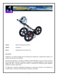
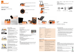
Survey Solutions
Rugged Cart System
•
•
•
•
•
•
•
•
•
•
Weather resistant design
Portable design with removable handle
Durable construction
Multiple antenna options (2600 MHz to 270 MHz)
Internal integrated survey wheel encoder
16-inch removable wheels
Adjustable bracket to change the controllers viewing angle
Robust military spec survey wheel connector
Marking paint can holders
Compatible with SIR-3000
UtilityScan
Standard Cart System
•
•
•
•
•
•
•
•
•
Lightweight and flexible design
Portable and foldable
Configurable antenna deployment options with center or front mounts
Multiple antenna options (2600 MHz to 400 MHz)
Integrated survey wheel encoder
20-inch front and 24-inch back removable wheels
Adjustable bracket to change the controllers viewing angle
Robust military spec survey wheel connector
Compatible with SIR-3000 and SIR-20
System Includes
•
•
•
•
•
•
•
•
•
•
SIR-3000 control unit
400 MHz or 270 MHz antenna
Rugged survey cart or Standard survey cart
Control cable
Transit case for SIR-3000
Two batteries and battery charger
AC adapter
User manual
Sun shade
Training (at GSSI: NH or CA)
Control Unit Specifications
•
•
•
•
•
•
•
•
Image Capacity: Internal: 500 2’x2’ data images
External Memory: Based on Compact Flash size
Internal Memory: 2 GB
Display: 8.4 inch, full-color, 800x600 resolution
64K colors, clearly visible in sunlight
Post-processing: On-screen
Battery: Internal (3 hours), 10.8 VDC
Ports: RS232, compact flash memory,
USB master & slave
Environmental: Water-resistant
Locate and Map Underground
Utilities with GPR
UtilityScan™ is the most accurate GPR system on the
market for the non-destructive designation of all types
of subsurface utilities. With UtilityScan, users can
immediately locate and mark buried service utilities (i.e.,
gas, electric and sewer lines).
This system provides real-time horizontal and vertical
position of a wide range of utility structures and buried
objects. UtilityScan scans most man-made or natural
surfaces, returning data with unsurpassed quality. You
can trust your results with GSSI’s powerful antennas.
Typical Uses
Designate Targets
•
Real-time data collection
•
Back up cursor allows the user to
accurately locate targets
Premium Mobility
•
Lightweight and portable
•
Durable components tested to withstand
the toughest conditions
Integrated System
•
Windows-based user interface
•
Ability to save data to an internal hard
drive
•
GPS integration
•
Utility detection – metallic and non-metallic
•
Environmental remediation
•
Damage prevention
•
Road inspection
•
Multiple antenna options
•
Geological investigation
•
•
Archaeology and forensics
Flexible system for concrete and bridge
inspection applications
•
Two-year warranty
Value
www.geophysical.com • [email protected]
Copyright © 2009 Geophysical Survey Systems, Inc.
July, 2009
12 Industrial Way • Salem, NH 03079-4843
Tel: (603) 893-1109 • Fax: (603) 889-3984
www.geophysical.com
UtilityScan
Solutions
UtilityScan
Flexibility
Utility locators, construction professionals,
environmental firms and land surveyors need a
reliable, non-destructive method to locate subsurface
targets prior to digging, trenching, conducting site
assessments and mapping.
The UtilityScan flexibility allows you to convert the
system to different application uses—no new data
collection software needed.
Concrete Scanning and
Inspection
Locate and Map
Underground Utilities
Use a 1600 MHz or 2600 MHz
antenna to designate reinforcing
steel and conduit within concrete
structures prior to cutting or
coring. Collect quantifiable data
on rebar location and areas of
deterioration.
Construction professionals, utility locators and
engineers can locate the depth and position of
metallic and non-metallic pipes in real time using
the GSSI UtilityScan. GPR can enhance one’s
overall understanding of subsurface targets and
obstructions.
Customize Your System
Choose your depth preference
1
0 - 12 feet*
(0 - 4 m)
400 MHz Antenna
0 - 18 feet*
(0 - 6 m)
270 MHz Antenna
Choose your survey cart
2
Rugged Cart
Standard Cart
UtilityScan data showing a duct bank with five utilities.
Also shown is a well-defined excavation trench.
Locate Underground Storage Tanks
Bridge Deck Inspection
By substituting a 1600 MHz antenna for the
400 MHz or 270 MHz antenna in the UtilityScan
cart, users can determine the condition of
aging bridge decks, parking
structures and obtain
accurate concrete cover
depth on new structures.
Use UtilityScan to accurately pinpoint underground
storage tanks and associated piping.
Choose your data presentation
3
Real-time 2D Profiles
Rebar in concrete pad
Edge of excavation
RADAN 3D Data
3 USTs
UtilityScan data depicting storage tanks under concrete pad
*Depth of penetration may vary depending upon ground
conditions. Contact GSSI for more details.
UtilityScan
Solutions
UtilityScan
Flexibility
Utility locators, construction professionals,
environmental firms and land surveyors need a
reliable, non-destructive method to locate subsurface
targets prior to digging, trenching, conducting site
assessments and mapping.
The UtilityScan flexibility allows you to convert the
system to different application uses—no new data
collection software needed.
Concrete Scanning and
Inspection
Locate and Map
Underground Utilities
Use a 1600 MHz or 2600 MHz
antenna to designate reinforcing
steel and conduit within concrete
structures prior to cutting or
coring. Collect quantifiable data
on rebar location and areas of
deterioration.
Construction professionals, utility locators and
engineers can locate the depth and position of
metallic and non-metallic pipes in real time using
the GSSI UtilityScan. GPR can enhance one’s
overall understanding of subsurface targets and
obstructions.
Customize Your System
Choose your depth preference
1
0 - 12 feet*
(0 - 4 m)
400 MHz Antenna
0 - 18 feet*
(0 - 6 m)
270 MHz Antenna
Choose your survey cart
2
Rugged Cart
Standard Cart
UtilityScan data showing a duct bank with five utilities.
Also shown is a well-defined excavation trench.
Locate Underground Storage Tanks
Bridge Deck Inspection
By substituting a 1600 MHz antenna for the
400 MHz or 270 MHz antenna in the UtilityScan
cart, users can determine the condition of
aging bridge decks, parking
structures and obtain
accurate concrete cover
depth on new structures.
Use UtilityScan to accurately pinpoint underground
storage tanks and associated piping.
Choose your data presentation
3
Real-time 2D Profiles
Rebar in concrete pad
Edge of excavation
RADAN 3D Data
3 USTs
UtilityScan data depicting storage tanks under concrete pad
*Depth of penetration may vary depending upon ground
conditions. Contact GSSI for more details.
Survey Solutions
Rugged Cart System
•
•
•
•
•
•
•
•
•
•
Weather resistant design
Portable design with removable handle
Durable construction
Multiple antenna options (2600 MHz to 270 MHz)
Internal integrated survey wheel encoder
16-inch removable wheels
Adjustable bracket to change the controllers viewing angle
Robust military spec survey wheel connector
Marking paint can holders
Compatible with SIR-3000
UtilityScan
Standard Cart System
•
•
•
•
•
•
•
•
•
Lightweight and flexible design
Portable and foldable
Configurable antenna deployment options with center or front mounts
Multiple antenna options (2600 MHz to 400 MHz)
Integrated survey wheel encoder
20-inch front and 24-inch back removable wheels
Adjustable bracket to change the controllers viewing angle
Robust military spec survey wheel connector
Compatible with SIR-3000 and SIR-20
System Includes
•
•
•
•
•
•
•
•
•
•
SIR-3000 control unit
400 MHz or 270 MHz antenna
Rugged survey cart or Standard survey cart
Control cable
Transit case for SIR-3000
Two batteries and battery charger
AC adapter
User manual
Sun shade
Training (at GSSI: NH or CA)
Control Unit Specifications
•
•
•
•
•
•
•
•
Image Capacity: Internal: 500 2’x2’ data images
External Memory: Based on Compact Flash size
Internal Memory: 2 GB
Display: 8.4 inch, full-color, 800x600 resolution
64K colors, clearly visible in sunlight
Post-processing: On-screen
Battery: Internal (3 hours), 10.8 VDC
Ports: RS232, compact flash memory,
USB master & slave
Environmental: Water-resistant
Locate and Map Underground
Utilities with GPR
UtilityScan™ is the most accurate GPR system on the
market for the non-destructive designation of all types
of subsurface utilities. With UtilityScan, users can
immediately locate and mark buried service utilities (i.e.,
gas, electric and sewer lines).
This system provides real-time horizontal and vertical
position of a wide range of utility structures and buried
objects. UtilityScan scans most man-made or natural
surfaces, returning data with unsurpassed quality. You
can trust your results with GSSI’s powerful antennas.
Typical Uses
Designate Targets
•
Real-time data collection
•
Back up cursor allows the user to
accurately locate targets
Premium Mobility
•
Lightweight and portable
•
Durable components tested to withstand
the toughest conditions
Integrated System
•
Windows-based user interface
•
Ability to save data to an internal hard
drive
•
GPS integration
•
Utility detection – metallic and non-metallic
•
Environmental remediation
•
Damage prevention
•
Road inspection
•
Multiple antenna options
•
Geological investigation
•
•
Archaeology and forensics
Flexible system for concrete and bridge
inspection applications
•
Two-year warranty
Value
www.geophysical.com • [email protected]
Copyright © 2009 Geophysical Survey Systems, Inc.
July, 2009
12 Industrial Way • Salem, NH 03079-4843
Tel: (603) 893-1109 • Fax: (603) 889-3984
www.geophysical.com
Utility Locating Antenna Solutions
400 MHz Antenna
The 400 MHz is ideally suited for detection and mapping of utility pipes,
as well as shallow engineering and environmental applications.
•
•
•
•
•
Center Frequency: 400 MHz
Depth Range: 0-12 ft (0-4 m)
Weight: 11 lbs (5 kg)
Dimensions: 12 x 12 x 6.5 in (30 x 30 x 17 cm)
Model 5103A
Data showing several utilities with bedrock horizon.
270 MHz Antenna
The 270 MHz is ideally suited for detection and mapping of utility pipes,
as well as shallow engineering and environmental applications.
•
•
•
•
•
Center Frequency: 270 MHz
Depth Range: 0-18 ft (0-6 m)
Weight: 18.5 lbs (8.6 kg)
Dimensions: 18 x 18 x 6.5 in (45 x 45 x 17 cm)
Model 5104 (U.S.), Model 5104A (International)
Six miscellaneous utilities at multiple depths with backfill on left side.
www.geophysical.com
Software Solutions: Interactive 3D
RADAN Software
RADAN™ is GSSI’s post-processing software. With its
modular design, this program allows users to select the
processing functions that best suit their needs.
RADAN is Windows™ based, providing a familiar
and easy-to-use environment for all levels of
experience.
Get More from Your Data with RADAN’s Interactive 3D Module
RADAN’s Interactive 3D Module provides powerful features for post-processing GSSI’s GPR data
and offers enhanced 3D viewing options in a single dialog box. Features include:
User-Friendly Interface
• Built for all levels of experience-RADAN’s Interactive 3D Module is a Windows™ based software
program that provides a familiar and easy-to-use setting for post-processing GPR data.
• Enhanced and simplified 3D viewing.
Easy Data Processing
• Take some of the human error out of the equation with semi-automatic
mapping of rebar locations and depths on simple concrete structures.
Interactive Interpretation
• Draw in or edit shapes that relate to your survey site (i.e. pipes, drums,
line).
• Stretch, shrink or zoom-in on files as desired for customized presentation
results.
• Slice through segments of data along various planes for easy interpretation
and supplementary information.
• Analyze multiple views of 2D and 3D data simultaneously.
Module Versatility
• This module allows for a broad range of civil/structural applications, including structures with
different types of reinforcement. Use the Structure ID Module in other applications to automatically
find point targets such as utility crossings or archaeological features with lower frequency antennas.
GPS Integration
• GSSI’s external data logger accepts data
from any GPS outputting the NMEA GCA
format.
Generic Output Files
• Outputs files for integration into AutoCAD
(2D & 3D .dxf) and ArcGIS (.shp).
Help Feature
• Help feature includes key information,
several “how to” guides, index and search
feature.
www.geophysical.com • [email protected]
Copyright © 2009 Geophysical Survey Systems, Inc.
July, 2009
12 Industrial Way • Salem, NH 03079-4843
Tel: (603) 893-1109 • Fax: (603) 889-3984