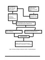
1
Acknowledgments
The 2001 edition of this volume of the manual was updated with advice
and consultation from a technical advisory group comprised of people
with considerable expertise and practical perspective. Ecology wishes to
thank the following for volunteering their time and sharing their expertise.
Name
Affiliation
Doug Beyerlein
Tom Holz
Richard Lindberg
Bruce Barker
Rose Peralta
Mike Heden
Kelly Whiting
Malcolm Leytham
Jim Albrecht
Tony Allen
Larry West
Mark Blosser
Ed Wiltsie
AQUA TERRA Consultants
SCA Engineering
Consulting Engineer
MGS Consultants
WSDOT, Tumwater
WSDOT, Spokane
King County Dept. of Natural Resources
Northwest Hydraulic Consultants
Consulting Engineer
WSDOT
HWA Geosciences, Inc.
City of Olympia
Jerome W. Morrissette & Associates
Ecology Technical Lead
Foroozan Labib – 2001 and 2005 updates
Ed O’Brien – 2005 update
Technical Review and Editing
Economic and Engineering Services, Inc. – 2001 update
Charlene Witczak – 2005 update
Kelsey Highfill – 2005 update
February 2005
Volume III – Hydrologic Analysis and Flow Control BMPs
i
ii
Volume III – Hydrologic Analysis and Flow Control BMPs
February 2005
Table of Contents
Acknowledgments....................................................................................................i
Chapter 1 - Introduction.....................................................................................1-1
1.1
1.2
1.3
Purpose of this Volume..................................................................................... 1-1
Content and Organization of this Volume ........................................................ 1-1
How to Use this Volume................................................................................... 1-2
Chapter 2 - Hydrologic Analysis ........................................................................2-1
2.1 Minimum Computational Standards ................................................................. 2-1
2.1.1 Discussion of Hydrologic Analysis Methods Used for Designing BMPs .. 2-3
2.2 Western Washington Hydrology Model ........................................................... 2-4
2.3 Single Event Hydrograph Method .................................................................... 2-9
2.3.1 Water Quality Design Storm..................................................................... 2-10
2.3.2 Runoff Parameters .................................................................................... 2-11
2.4 Closed Depression Analysis ........................................................................... 2-17
Chapter 3 - Flow Control Design .......................................................................3-1
3.1 Roof Downspout Controls ................................................................................ 3-2
3.1.1 Downspout Infiltration Systems ................................................................. 3-4
3.1.2 Downspout Dispersion Systems ............................................................... 3-11
3.1.3 Perforated Stub-Out Connections ............................................................. 3-17
3.2 Detention Facilities ......................................................................................... 3-19
3.2.1 Detention Ponds ........................................................................................ 3-19
3.2.2 Detention Tanks ........................................................................................ 3-40
3.2.3 Detention Vaults ....................................................................................... 3-46
3.2.4 Control Structures ..................................................................................... 3-50
3.2.5 Other Detention Options ........................................................................... 3-64
3.3 Infiltration Facilities for Flow Control and for Treatment.............................. 3-65
3.3.1 Purpose...................................................................................................... 3-65
3.3.2 Description................................................................................................ 3-65
3.3.3 Applications .............................................................................................. 3-65
3.3.4 Simplified Approach (Figure 3.26)........................................................... 3-67
3.3.5 Site Characterization Criteria.................................................................... 3-70
3.3.6 Design Infiltration Rate Determination – Guidelines and Criteria ........... 3-75
3.3.7 Site Suitability Criteria (SSC)................................................................... 3-81
3.3.8 Detailed Approach (Figure 3.29) .............................................................. 3-85
3.3.9 General Design, Maintenance, and Construction Criteria for Infiltration
Facilities.................................................................................................... 3-94
3.3.10 Infiltration Basins...................................................................................... 3-97
3.3.11 Infiltration Trenches.................................................................................. 3-98
Volume III References.....................................................................................Ref-1
February 2005
Volume III – Hydrologic Analysis and Flow Control BMPs
iii
Appendix III-A Isopluvial Maps for Design Storms .......................................A-1
Appendix III-B Western Washington Hydrology Model – Information,
Assumptions, and Computation Steps ...................................B-1
Appendix III-C Washington State Department of Ecology Low Impact
Development Design and Flow Modeling Guidance .............C-1
Appendix III-D Procedure for Conducting a Pilot Infiltration Test .............D-1
Tables
Table 2.1
Table 2.2
Hydrologic Soil Series for Selected Soils in Washington State ................. 2-11
Runoff Curve Numbers for Selected Agricultural, Suburban,
and Urban Areas......................................................................................... 2-15
Table 3.1 Small Trees and Shrubs with Fibrous Roots .............................................. 3-28
Table 3.2 Stormwater Tract “Low Grow” Seed Mix ................................................. 3-30
Table 3.3 Specific Maintenance Requirements for Detention Ponds......................... 3-36
Table 3.4 Specific Maintenance Requirements for Detention Vaults/Tanks ............. 3-43
Table 3.5 Maintenance of Control Structures and Catchbasins ................................. 3-55
Table 3.6 Values of Cd for Sutro Weirs...................................................................... 3-62
Table 3.7 Recommended Infiltration Rates based on USDA Soil Textural
Classification. ............................................................................................. 3-76
Table 3.8 Alternative Recommended Infiltration Rates based on ASTM
Gradation Testing. ...................................................................................... 3-77
Table 3.9 Correction Factors to be Used With In-Situ Infiltration
Measurements to Estimate Long-Term Design Infiltration Rates.............. 3-80
Table 3-10 Infiltration Rate Reduction Factors to Account for Biofouling and
Siltation Effects for Ponds.......................................................................... 3-92
iv
Volume III – Hydrologic Analysis and Flow Control BMPs
February 2005
Figures
Figure 3.1
Figure 3.2
Figure 3.3
Figure 3.4
Figure 3.5
Figure 3.6
Figure 3.7
Figure 3.8
Figure 3.9
Figure 3.10
Figure 3.11
Figure 3.12
Figure 3.13
Figure 3.14
Figure 3.15
Figure 3.16
Figure 3.17
Figure 3.18
Figure 3.19
Figure 3.20
Figure 3.21
Figure 3.22
Figure 3.23
Figure 3.24
Figure 3.25
Figure 3.26
Figure 3.27
Figure 3.28
Figure 3.29
Figure 3.30
Figure 3.31
February 2005
Flow Diagram Showing Selection of Roof Downspout Controls ............. 3-3
Typical Downspout Infiltration Trench..................................................... 3-7
Alternative Downspout Infiltration Trench System for Coarse
Sand and Gravel ........................................................................................ 3-8
Typical Downspout Infiltration Drywell................................................... 3-9
Typical Downspout Dispersion Trench................................................... 3-13
Standard Dispersion Trench with Notched Grade Board........................ 3-14
Typical Downspout Splashblock Dispersion .......................................... 3-16
Perforated Stub-Out Connection ............................................................ 3-18
Typical Detention Pond.......................................................................... 3-31
Typical Detention Pond Sections ............................................................ 3-32
Overflow Structure .................................................................................. 3-33
Example of Permanent Surface Water Control Pond Sign ..................... 3-34
Weir Section for Emergency Overflow Spillway.................................... 3-40
Typical Detention Tank........................................................................... 3-44
Detention Tank Access Detail................................................................. 3-45
Typical Detention Vault .......................................................................... 3-49
Flow Restrictor (TEE) ............................................................................. 3-52
Flow Restrictor (Baffle) .......................................................................... 3-53
Flow Restrictor (Weir) ............................................................................ 3-54
Simple Orifice ......................................................................................... 3-58
Rectangular, Sharp-Crested Weir............................................................ 3-59
V-Notch, Sharp-Crested Weir ................................................................. 3-60
Sutro Weir ............................................................................................... 3-61
Riser Inflow Curves................................................................................. 3-63
Typical Infiltration Pond/Basin ............................................................... 3-66
Steps for Design of Infiltration Facilities – Simplified Approach .......... 3-69
USDA Textural Triangle ......................................................................... 3-74
Infiltration Rate as a Function of the D10 Size of the Soil ............................
for Ponds in Western Washington........................................................... 3-78
Engineering Design Steps for Final Design of Infiltration Facilities
Using the Continuous Hydrograph Method ............................................ 3-88
Schematic of an Infiltration Trench......................................................... 3-99
Parking Lot Perimeter Trench Design..................................................... 3-99
Volume III – Hydrologic Analysis and Flow Control BMPs
v
Figure 3.32
Figure 3.33
Figure 3.34
Figure 3.35
Figure 3.36
vi
Median Strip Trench Design ................................................................. 3-100
Oversized Pipe Trench Design .............................................................. 3-100
Swale/Trench Design ............................................................................ 3-101
Underground Trench with Oil/Grit Chamber ........................................ 3-101
Observation Well Details ...................................................................... 3-104
Volume III – Hydrologic Analysis and Flow Control BMPs
February 2005
Chapter 1 - Introduction
1.1
Purpose of this Volume
Best Management Practices (BMPs) are schedules of activities,
prohibitions of practices, maintenance procedures, managerial practices, or
structural features that prevent or reduce adverse impacts to waters of
Washington State. As described in Volume I of this stormwater manual,
BMPs for long-term management of stormwater at developed sites can be
divided into three main categories:
•
BMPs addressing the volume and timing of stormwater flows;
•
BMPs addressing prevention of pollution from potential sources; and
•
BMPs addressing treatment of runoff to remove sediment and other
pollutants.
This volume of the stormwater manual focuses mainly on the first
category. It presents techniques of hydrologic analysis, and BMPs related
to management of the amount and timing of stormwater flows from
developed sites. The purpose of this volume is to provide guidance on the
estimation and control of stormwater runoff quantity.
BMPs for preventing pollution of stormwater runoff and for treating
contaminated runoff are presented in Volumes IV and V, respectively.
1.2
Content and Organization of this Volume
Volume III of the stormwater manual contains three chapters. Chapter 1
serves as an introduction. Chapter 2 reviews methods of hydrologic
analysis, covers the use of hydrograph methods for designing BMPs, and
provides an overview of various computerized modeling methods and
analysis of closed depressions. Chapter 3 describes flow control BMPs
and provides design specifications for roof downspouts and detention
facilities. It also provides design considerations of infiltration facilities for
flow control.
This volume includes three appendices. Appendix A has isopluvial maps
for western Washington. Appendix B has information and assumptions on
the Western Washington Hydrology Model (WWHM). Appendix C
includes detailed information concerning how to represent various Low
Impact Development (LID) techniques in continuous runoff models so that
the models predict lower surface runoff rates and volumes.
February 2005
Volume III – Hydrologic Analysis and Flow Control BMPs
1-1
Design considerations for conveyance systems are not included in the
stormwater manual, as this topic is adequately covered in standard
engineering references.
1.3
How to Use this Volume
Volume I should be consulted to determine Minimum Requirements for
flow management (e.g. Minimum Requirements #4, #5 and #7 in Chapter
2 of Volume I). After the Minimum Requirements have been determined,
this volume should be consulted to design flow management facilities.
These facilities can then be included in Stormwater Site Plans (see
Volume I, Chapter 3).
1-2
Volume III – Hydrologic Analysis and Flow Control BMPs
February 2005
Chapter 2 - Hydrologic Analysis
The broad definition of hydrology is “the science which studies the source,
properties, distribution, and laws of water as it moves through its closed
cycle on the earth (the hydrologic cycle).” As applied in this manual,
however, the term “hydrologic analysis” addresses and quantifies only a
small portion of this cycle. That portion is the relatively short-term
movement of water over the land resulting directly from precipitation and
called surface water or stormwater runoff. Localized and long-term
ground water movement must also be of concern, but generally only as
this relates to the movement of water on or near the surface, such as
stream base flow or infiltration systems.
The purpose of this chapter is to define the minimum computational
standards required, to outline how these may be applied, and to reference
where more complete details may be found, should they be needed. This
chapter also provides details on the hydrologic design process; that is, what
are the steps required in conducting a hydrologic analysis, including flow
routing.
2.1
Minimum Computational Standards
The minimum computational standards depend on the type of information
required and the size of the drainage area to be analyzed, as follows:
1.
For the purpose of designing most types of runoff treatment BMPs,
a calibrated continuous simulation hydrologic model based on the
EPA’s HSPF (Hydrologic Simulation Program-Fortran) program,
or an approved equivalent model, must be used to calculate runoff
and determine the water quality design flow rates and volumes.
For the purpose of designing wetpool treatment facilities, there are
two acceptable methods: an approved continuous runoff model to
estimate the 91st percentile, 24-hour runoff volume, or the NRCS
(Natural Resources Conservation Service) curve number method to
determine a water quality design storm volume. The water quality
design storm volume is the amount of runoff predicted from the 6month, 24-hour storm.
For the purpose of designing flow control BMPs, a calibrated
continuous simulation hydrologic model, based on the EPA’s
HSPF, must be used.
The circumstances under which different methodologies apply are
summarized below.
February 2005
Volume III – Hydrologic Analysis and Flow Control BMPs
2-1
Summary of the application design methodologies
BMP designs in western Washington
Method
Treatment
Flow Control
SCSUH/SBUH (Soil
Method applies for
Conservation Service Unit
BMPs that are sized
Hydrograph/Santa Barbara
based on the volume of
Unit Hydrograph)
runoff from a 6-month,
24-hour storm.
Currently, that includes
only wetpool-facilities.
Note: These BMPs don’t
require generating a
hydrograph.
Not Applicable
Continuous Runoff Models:
Method applies to all
Method applies
(WWHM or approved
BMPs.
throughout Western
alternatives. See below)
Washington
2.
If a basin plan is being prepared, then a hydrologic analysis should
be performed using a continuous simulation model such as the
EPA's HSPF model, the EPA's Stormwater Management Model
(SWMM), or an equivalent model as approved by the local
government.
Significant progress has been made in the development and
availability of HSPF-based continuous runoff models for Western
Washington. The Department of Ecology has coordinated the
development of the Western Washington Hydrology Model
(WWHM). It uses rainfall/runoff relationships developed for
specific basins in the Puget Sound region to all parts of western
Washington. Where field monitoring establishes basin-specific
rainfall/runoff parameter calibrations, those can be entered into the
model, superseding the default input parameters.
Two other HSPF-based continuous runoff models have been
approved by the Department of Ecology: MGS Flood and KCRTS
(King County Runoff Time Series). Though MGS Flood uses
different, extended precipitation files, its features and more
importantly, its runoff estimations are very similar to those
predicted by WWHM. KCRTS is a pre-packaged set of runoff
files developed by King County. It can be used throughout King
County. Use of other continuous simulation models should receive
prior concurrence from the Dept. of Ecology.
Where large master-planned developments are proposed, local
governments should consider requiring a basin-specific calibration
of HSPF rather than use of the default parameters in the abovereferenced models. The Department of Ecology suggests such
2-2
Volume III – Hydrologic Analysis and Flow Control BMPs
February 2005
basin-specific calibrations should be considered for projects that
will occupy more than 320 acres.
2.1.1 Discussion of Hydrologic Analysis Methods Used for Designing
BMPs
This section provides a discussion of the methodologies to be used for
calculating stormwater runoff from a project site. It includes a discussion
of estimating stormwater runoff with single event models, such as the
SBUH, versus continuous simulation models.
Single Event
and
Continuous
Simulation
Model
A continuous simulation model has considerable advantages over
the single event-based methods such as the SCSUH, SBUH, or the
Rational Method. HSPF is a continuous simulation model that is
capable of simulating a wider range of hydrologic responses than
the single event models such as the SBUH method. Single event
models cannot take into account storm events that may occur just
before or just after the single event (the design storm) that is under
consideration. In addition, the runoff files generated by the HSPF
models are the result of a considerable effort to introduce local
parameters and actual rainfall data into the model and therefore
produce better estimations of runoff than the SCSUH, SBUH, or
Rational methods.
Ecology has developed a continuous simulation hydrologic model
(WWHM) based on the HSPF for use in western Washington (see
Section 2.2). Continuous rainfall records/data files have been
obtained and appropriate adjustment factors were developed as
input to HSPF. Input algorithms (referred to as IMPLND and
PERLND) have been developed for a number of watershed basins
in King, Pierce, Snohomish, and Thurston counties. These rainfall
files and model algorithms are used in the HSPF in western
Washington. Local counties and cities are encouraged to develop
basin-specific calibrations of HSPF that can be input into the
WWHM. However, until such a calibration is developed for a
specific basin, the input data mentioned above must be used
throughout western Washington.
Concerns with
SBUH
A summary of the concerns with SBUH and other single event models is
in order.
•
February 2005
While SBUH may give acceptable estimates of total runoff volumes, it
tends to overestimate peak flow rates from pervious areas because it
cannot adequately model subsurface flow (which is a dominant flow
regime for pre-development conditions in western Washington basins).
One reason SBUH overestimates the peak flow rate for pervious areas
Volume III – Hydrologic Analysis and Flow Control BMPs
2-3
is that the actual time of concentration is typically greater than what is
assumed. Better flow estimates could be made if a longer time of
concentration was used. This would change both the peak flow rate
(i.e., it would be lower) and the shape of the hydrograph (i.e., peak
occurs somewhat later) such that the hydrograph would better reflect
actual predeveloped conditions.
Another reason for overestimation of the runoff is the curve numbers (CN)
in the 1992 Manual. These curve numbers were developed by US-Natural
Resources Conservation Service (NRCS), formerly the Soil Conservation
Service (SCS) and published as the Western Washington Supplemental
Curve Numbers. These CN values are typically higher than the standard
CN values published in Technical Release 55, June 1986. In 1995, the
NRCS recalled the use of the western Washington CNs for floodplain
management and found that the standard CNs better describe the
hydrologic conditions for rainfall events in western Washington.
However, based on runoff comparisons with the KCRTS better estimates
of runoff are obtained when using the western Washington CNs for the
developed areas such as parks, lawns, and other landscaped areas.
Accordingly, the CNs in this manual (see Table 2.3) are changed to those
in the Technical Release 55 except for the open spaces category for the
developed areas which include, lawn, parks, golf courses, cemeteries, and
landscaped areas. For these areas, the western Washington CNs are used.
These changes are intended to provide better runoff estimates using the
SBUH method.
Another major weakness of SBUH is that it is used to model a 24-hour
storm event, which is too short to model longer-term storms in western
Washington. The use of a longer-term (e.g. 3- or 7-day storm) is perhaps
better suited for western Washington.
Related to the last concern is the fact that single event approaches, such as
SBUH, assume that flow control ponds are empty at the start of the design
event. Continuous runoff models are able to simulate a continuous longterm record of runoff and soil moisture conditions. They simulate
situations where ponds are not empty when another rain event begins.
Finally, single event models do not allow for estimation and analyses of
flow durations nor water level fluctuations. Flow durations are necessary
for discharges to streams. Estimates of water level fluctuations are
necessary for discharges to wetlands and for tracking influent water
elevations and bypass quantities to properly size treatment facilities.
2.2
Western Washington Hydrology Model
This section summarizes the assumptions made in creating the western
Washington Hydrology Model (WWHM) and discusses limitations of the
2-4
Volume III – Hydrologic Analysis and Flow Control BMPs
February 2005
model. More information on the WWHM and the assumptions can be
found in Appendix III-B.
Limitations to the WWHM
The WWHM has been created for the specific purpose of sizing
stormwater control facilities for new developments in western
Washington. The WWHM can be used for a range of conditions and
developments; however, certain limitations are inherent in this software.
These limitations are described below.
The WWHM uses the EPA HSPF software program to do all of the
rainfall-runoff and routing computations. Therefore, HSPF limitations
are included in the WWHM. For example, backwater or tailwater
control situations are not explicitly modeled by HSPF. This is also
true in the WWHM.
In addition, the WWHM is limited in its routing capabilities. The user is
allowed to input multiple stormwater control facilities and runoff is routed
through them. If the proposed development site involves routing through
a natural lake or wetland in addition to multiple stormwater control
facilities then the user should use HSPF to do the routing computations
and additional analysis.
Routing effects become more important as the drainage area increases.
For this reason it is recommended that the WWHM not be used for
drainage areas greater than one-half square mile (320 acres). The WWHM
can be used for small drainage areas less than an acre in size.
Assumptions made in creating the WWHM
Precipitation data.
February 2005
•
The WWHM uses long-term (43-50 years) precipitation data to
simulate the potential impacts of land use development in western
Washington. A minimum period of 20 years is required to simulate
enough peak flow events to produce accurate flow frequency results.
•
A total of 17 precipitation stations are used, representing the different
rainfall regimes found in western Washington.
•
These stations represent rainfall at elevations below 1500 feet snowfall and snowmelt are not included in the WWHM.
•
The primary source for precipitation data is National Weather Service
stations.
•
The base computational time step used in the WWHM is one hour.
The one-hour time step was selected to better represent the temporal
Volume III – Hydrologic Analysis and Flow Control BMPs
2-5
variability of actual precipitation than daily data. Based on more
frequent (15-minute) rain data collected over 25 years in Seattle, a
relationship has been developed and incorporated in WWHM for
converting the 60-minute water quality design flows to 15-minute
flows. The 15-minute water quality design flows are more appropriate
and must be used for design of water quality treatment facilities that
are expected to have a hydraulic residence time of less than one hour.
Precipitation multiplication factors.
•
The WWHM uses precipitation multiplication factors to increase or
decrease recorded precipitation data to better represent local rainfall
conditions.
•
The factors are based on the ratio of the 24-hour, 25-year rainfall
intensities for the representative precipitation gage and the surrounding
area represented by that gage’s record.
•
The factors have been placed in the WWHM database and linked to
each county’s map. They will be transparent to the general user,
however the advanced user will have the ability to change the
coefficient for a specific site. Changes made by the user will be
recorded in the WWHM output. By default, WWHM does not allow
the precipitation multiplication factor to go below 0.8 or above 2.
Pan evaporation data.
•
The WWHM uses pan evaporation coefficients to compute the actual
evapotranspiration potential (AET) for a site, based on the potential
evapotranspiration (PET) and available moisture supply. AET
accounts for the precipitation that returns to the atmosphere without
becoming runoff.
•
The pan evaporation coefficients have been placed in the WWHM
database and linked to each county’s map. They will be transparent to
the general user. The advanced user will have the ability to change the
coefficient for a specific site. These changes will be recorded in the
WWHM output.
Soil data.
2-6
•
The WWHM uses three predominate soil type to represent the soils of
western Washington: till, outwash, and saturated.
•
The user determines actual local soil conditions for the specific
development planned and inputs that data into the WWHM. The user
inputs the number of acres of outwash (A/B), till (C/D), and saturated
(wetland) soils for the site conditions.
•
Additional soils will be included in the WWHM if appropriate HSPF
parameter values are found to represent other major soil groups.
Volume III – Hydrologic Analysis and Flow Control BMPs
February 2005
Vegetation data.
•
The WWHM will represent the vegetation of western Washington with
three predominate vegetation categories: forest, pasture, and lawn (also
known as grass).
•
The predevelopment land conditions are generally assumed as forest
(the default condition), however, the user has the option of specifying
pasture if there is documented evidence that pasture vegetation was
native to the predevelopment site. In highly urbanized basins (see
Minimum Requirement #7 in Volume I, Chapter 2, it is possible to use
the existing land cover as the pre-developed land condition.
Development land use data.
•
Development land use data are used to represent the type of
development planned for the site and are used to determine the
appropriate size of the required stormwater mitigation facility.
•
Among the land uses options, WWHM includes a Standard residential
development which makes specific assumptions about the amount of
impervious area per lot and its division between driveways and
rooftops. Streets and sidewalk areas are input separately. Ecology has
selected a standard impervious area of 4200 square feet per residential
lot, with 1000 square feet of that as driveway, walkways, and patio
area, and the remainder as rooftop area.
•
The WWHM distinguishes between effective impervious area and
non-effective impervious area in calculating total impervious area.
•
Credits are given for infiltration and dispersion of roof runoff and for
use of porous pavement for driveway areas. The WWHM2 currently
includes an option for obtaining credits for the use of porous
pavements on Streets/Sidewalk/Parking. The credit given under this
option is believed to be too small. Until such time as WWHM2 is
upgraded to WWHM3, the LID credit guidance in Appendix C should
be followed for porous pavements.
•
Forest and pasture vegetation areas are only appropriate for separate
undeveloped parcels dedicated as open space, wetland buffer, or park
within the total area of the development. Development areas must
only be designated as forest or pasture where legal restrictions can
be documented that protect these areas from future disturbances.
•
The WWHM can model bypassing a portion of the runoff from the
development area around a stormwater detention facility and/or having
offsite inflow enter the development area.
Application of WWHM in Re-developments Projects
February 2005
Volume III – Hydrologic Analysis and Flow Control BMPs
2-7
Redevelopment requirements may allow, for some portions of the
redevelopment project area, the predeveloped condition to be modeled as
the existing condition rather than forested or pasture condition. For
instance, where the replaced impervious areas do not have to be served by
updated flow control facilities because area or cost thresholds in Section
2.4.2 of Volume I are not exceeded. .
Pervious and Impervious Land Categories (PERLND and IMPLND
parameter values)
•
In WWHM (and HSPF) pervious land categories are represented by
PERLNDs; impervious land categories by IMPLNDs
•
The WWHM provides 16 unique PERLND parameters that describe
various hydrologic factors that influence runoff and 4 parameters to
represent IMPLND.
•
These values are based on regional parameter values developed by the
U.S. Geological Survey for watersheds in western Washington
(Dinicola, 1990) plus additional HSPF modeling work conducted by
AQUA TERRA Consultants.
•
Surface runoff and interflow will be computed based on the PERLND
and IMPLND parameter values. Groundwater flow can also be
computed and added to the total runoff from a development if there is
a reason to believe that groundwater would be surfacing (such where
there is a cut in a slope). However, the default condition in WWHM
assumes that no groundwater flow from small catchments reaches the
surface to become runoff. This is consistent with King County
procedures (King County, 1998).
Guidance for flow control standards.
Flow control standards are used to determine whether or not a proposed
stormwater facility will provide a sufficient level of mitigation for the
additional runoff from land development.
There are two flow control standards stated in the Ecology Manual:
Minimum Requirement #7 - Flow Control and Minimum Requirement
#8 - Wetlands Protection (See Volume I). Minimum Requirement #7
specifies specific flow frequency and flow duration ranges for which
the postdevelopment runoff cannot exceed predevelopment runoff.
Minimum Requirement #8 specifies that discharges to wetlands must
maintain the hydrologic conditions, hydrophytic vegetation, and
substrate characteristics necessary to support existing and designated
beneficial uses.
2-8
Volume III – Hydrologic Analysis and Flow Control BMPs
February 2005
Minimum Requirement #7 specifies that stormwater discharges to
streams shall match developed discharge durations to predeveloped
durations for the range of predeveloped discharge rates from 50% of
the 2-year peak flow up to the full 50-year peak flow. .
•
The WWHM computes the predevelopment 2- through 100-year flow
frequency values and computes the post-development runoff 2through 100-year flow frequency values from the outlet of the
proposed stormwater facility.
•
The model uses pond discharge data to compare the predevelopment
and postdevelopment durations and determines if the flow control
standards have been met.
•
There are three criteria by which flow duration values are compared:
1. If the postdevelopment flow duration values exceed any of the
predevelopment flow levels between 50% and 100% of the 2-year
predevelopment peak flow values (100 Percent Threshold) then the
flow duration requirement has not been met.
2. If the postdevelopment flow duration values exceed any of the
predevelopment flow levels between 100% of the 2-year and 100%
of the 50-year predevelopment peak flow values more than 10
percent of the time (110 Percent Threshold) then the flow duration
requirement has not been met.
3. If more than 50 percent of the flow duration levels exceed the 100
percent threshold then the flow duration requirement has not been
met.
Minimum Requirement #8 specifies that discharges to wetlands must
maintain the hydrologic conditions, hydrophytic vegetation, and substrate
characteristics necessary to support existing and designated beneficial
uses. Criteria for determining maximum allowed exceedences in
alterations to wetland hydroperiods are provided in guidelines cited in
Guide Sheet 2B of the Puget Sound Wetland Guidelines (Azous and
Horner, 1997). Because wetland hydroperiod computations are relatively
complex and are site specific they have not yet been included in the
WWHM2. HSPF is required for wetland hydroperiod analysis. Ecology
intends to include the ability to perform hydroperiod computations in
WWHM3.
2.3
Single Event Hydrograph Method
Hydrograph analysis utilizes the standard plot of runoff flow versus time
for a given design storm, thereby allowing the key characteristics of runoff
February 2005
Volume III – Hydrologic Analysis and Flow Control BMPs
2-9
such as peak, volume, and phasing to be considered in the design of
drainage facilities. Because the only utility for single event methods in
this manual is to size wet pool treatment facilities, only the subjects of
design storms, curve numbers and calculating runoff volumes are
presented. If single event methods are used to size temporary and
permanent conveyances, the reader should reference other texts and
software for assistance.
2.3.1 Water Quality Design Storm
The design storm for sizing wetpool treatment facilities is the 6-month,
24-hour storm. Unless amended to reflect local precipitation statistics, the
6-month, 24-hour precipitation amount may be assumed to be 72 percent
of the 2-year, 24-hour amount. Precipitation estimates of the 6-month and
2-year, 24-hour storms for certain towns and cities are listed in Appendix
1-B of Volume I. For other areas, interpolating between isopluvials for
the 2-year, 24-hour precipitation and multiplying by 72% yields the
appropriate storm size.
The total depth of rainfall (in tenths of an inch) for storms of 24-hour
duration and 2, 5, 10, 25, 50, and 100-year recurrence intervals are
published by the National Oceanic and Atmospheric Administration
(NOAA). The information is presented in the form of “isopluvial” maps
for each state. Isopluvial maps are maps where the contours represent
total inches of rainfall for a specific duration. Isopluvial maps for the 2, 5,
10, 25, 50, and 100-year recurrence interval and 24-hour duration storm
events can be found in the NOAA Atlas 2, “Precipitation - Frequency
Atlas of the Western United States, Volume IX-Washington.” Appendix
II-A provides the isopluvials for the 2, 10, and 100-year, 24-hour design
storms. Other precipitation frequency data may be obtained through
Western Regional Climate Center (WRCC) at Tel: (775) 674-7010.
WRCC can generate 1-30 day precipitation frequency data for the location
of interest using data from 1948 to present (currently August 2000).
2-10
Volume III – Hydrologic Analysis and Flow Control BMPs
February 2005
2.3.2 Runoff Parameters
All storm event hydrograph methods require input of parameters that
describe physical drainage basin characteristics. These parameters provide
the basis from which the runoff hydrograph is developed. This section
describes only the key parameter of curve number that is used to estimate the
runoff from the water quality design storm. .
Curve Number
The NRCS (formerly SCS) has, for many years, conducted studies of the
runoff characteristics for various land types. After gathering and
analyzing extensive data, NRCS has developed relationships between land
use, soil type, vegetation cover, interception, infiltration, surface storage,
and runoff. The relationships have been characterized by a single runoff
coefficient called a “curve number.” The National Engineering Handbook
- Section 4: Hydrology (NEH-4, SCS, August 1972) contains a detailed
description of the development and use of the curve number method.
NRCS has developed “curve number” (CN) values based on soil type and
land use. They can be found in “Urban Hydrology for Small Watersheds”,
Technical Release 55 (TR-55), June 1986, published by the NRCS. The
combination of these two factors is called the “soil-cover complex.” The
soil-cover complexes have been assigned to one of four hydrologic soil
groups, according to their runoff characteristics. NRCS has classified over
4,000 soil types into these four soil groups. Table 2.2 shows the
hydrologic soil group of most soils in the state of Washington and
provides a brief description of the four groups. For details on other soil
types refer to the NRCS publication mentioned above (TR-55, 1986).
Table 2.1 Hydrologic Soil Series for Selected Soils in Washington State
Soil Type
Agnew
Ahl
Aits
Alderwood
Arents, Alderwood
Arents, Everett
Ashoe
Baldhill
Barneston
Baumgard
Beausite
Belfast
Bellingham
Bellingham variant
Boistfort
Bow
Briscot
Buckley
Bunker
Cagey
Carlsborg
Casey
February 2005
Hydrologic Soil Group
C
B
C
C
B
B
B
B
C
B
B
C
D
C
B
D
D
C
B
C
A
D
Soil Type
Hoko
Hoodsport
Hoogdal
Hoypus
Huel
Indianola
Jonas
Jumpe
Kalaloch
Kapowsin
Katula
Kilchis
Kitsap
Klaus
Klone
Lates
Lebam
Lummi
Lynnwood
Lystair
Mal
Manley
Volume III – Hydrologic Analysis and Flow Control BMPs
Hydrologic Soil Group
C
C
C
A
A
A
B
B
C
C/D
C
C
C
C
B
C
B
D
A
B
C
B
2-11
Table 2.1 Hydrologic Soil Series for Selected Soils in Washington State
Soil Type
Cassolary
Cathcart
Centralia
Chehalis
Chesaw
Cinebar
Clallam
Clayton
Coastal beaches
Colter
Custer
Custer, Drained
Dabob
Delphi
Dick
Dimal
Dupont
Earlmont
Edgewick
Eld
Elwell
Esquatzel
Everett
Everson
Galvin
Getchell
Giles
Godfrey
Greenwater
Grove
Harstine
Hartnit
Hoh
Puget
Puyallup
Queets
Quilcene
Ragnar
Rainier
Raught
Reed
Reed, Drained or Protected
Renton
Republic
Riverwash
Rober
Salal
Salkum
Sammamish
San Juan
Scamman
Schneider
Seattle
Sekiu
Semiahmoo
Shalcar
Shano
Shelton
Si
2-12
Hydrologic Soil Group
C
B
B
B
A
B
C
B
variable
C
D
C
C
D
A
D
D
C
C
B
B
B
A
D
D
A
B
D
A
C
C
C
B
D
B
B
C
B
C
B
D
C
D
B
variable
C
C
B
D
A
D
B
D
D
D
D
B
C
C
Soil Type
Mashel
Maytown
McKenna
McMurray
Melbourne
Menzel
Mixed Alluvial
Molson
Mukilteo
Naff
Nargar
National
Neilton
Newberg
Nisqually
Nooksack
Norma
Ogarty
Olete
Olomount
Olympic
Orcas
Oridia
Orting
Oso
Ovall
Pastik
Pheeney
Phelan
Pilchuck
Potchub
Poulsbo
Prather
Solleks
Spana
Spanaway
Springdale
Sulsavar
Sultan
Sultan variant
Sumas
Swantown
Tacoma
Tanwax
Tanwax, Drained
Tealwhit
Tenino
Tisch
Tokul
Townsend
Triton
Tukwila
Tukey
Urbana
Vailton
Verlot
Wapato
Warden
Whidbey
Volume III – Hydrologic Analysis and Flow Control BMPs
Hydrologic Soil Group
B
C
D
D
B
B
variable
B
C/D
B
A
B
A
B
B
C
C/D
C
C
C
B
D
D
D
C
C
C
C
D
C
C
C
C
C
D
A/B
B
B
C
B
C
D
D
D
C
D
C
D
C
C
D
D
C
C
B
C
D
B
C
February 2005
Table 2.1 Hydrologic Soil Series for Selected Soils in Washington State
Soil Type
Sinclair
Skipopa
Skykomish
Snahopish
Snohomish
Solduc
Hydrologic Soil Group
C
D
B
B
D
B
Soil Type
Wilkeson
Winston
Woodinville
Yelm
Zynbar
Hydrologic Soil Group
B
A
B
C
B
Notes:
Hydrologic Soil Group Classifications, as Defined by the Soil Conservation Service:
A = (Low runoff potential) Soils having low runoff potential and high infiltration rates, even when thoroughly wetted. They
consist chiefly of deep, well to excessively drained sands or gravels and have a high rate of water transmission (greater than
0.30 in/hr.).
B = (Moderately low runoff potential). Soils having moderate infiltration rates when thoroughly wetted and consist chiefly of
moderately deep to deep, moderately well to well drained soils with moderately fine to moderately coarse textures. These
soils have a moderate rate of water transmission (0.15-0.3 in/hr.).
C = (Moderately high runoff potential). Soils having low infiltration rates when thoroughly wetted and consist chiefly of soils
with a layer that impedes downward movement of water and soils with moderately fine to fine textures. These soils have a
low rate of water transmission (0.05-0.15 in/hr.).
D = (High runoff potential). Soils having high runoff potential. They have very low infiltration rates when thoroughly wetted
and consist chiefly of clay soils with a high swelling potential, soils with a permanent high water table, soils with a hardpan
or clay layer at or near the surface, and shallow soils over nearly impervious material. These soils have a very low rate of
water transmission (0-0.05 in/hr.).
* = From SCS, TR-55, Second Edition, June 1986, Exhibit A-1. Revisions made from SCS, Soil Interpretation Record, Form #5,
September 1988 and various county soil surveys.
Table 2.3 shows the CNs, by land use description, for the four hydrologic
soil groups. These numbers are for a 24-hour duration storm and typical
antecedent soil moisture condition preceding 24-hour storms.
The following are important criteria/considerations for selection of CN
values:
Many factors may affect the CN value for a given land use. For example,
the movement of heavy equipment over bare ground may compact the soil
so that it has a lesser infiltration rate and greater runoff potential than
would be indicated by strict application of the CN value to developed site
conditions.
CN values can be area weighted when they apply to pervious areas of
similar CNs (within 20 CN points). However, high CN areas should not
be combined with low CN areas. In this case, separate estimates of S
(potential maximum natural detention) and Qd (runoff depth) should be
generated and summed to obtain the cumulative runoff volume unless the
low CN areas are less than 15 percent of the subbasin.
Separate CN values must be selected for the pervious and impervious
areas of an urban basin or subbasin. For residential districts the percent
impervious area given in Table 2.3 must be used to compute the respective
February 2005
Volume III – Hydrologic Analysis and Flow Control BMPs
2-13
pervious and impervious areas. For proposed commercial areas, planned
unit developments, etc., the percent impervious area must be computed
from the site plan. For all other land uses the percent impervious area
must be estimated from best available aerial topography and/or field
reconnaissance. The pervious area CN value must be a weighted average
of all the pervious area CNs within the subbasin. The impervious area CN
value shall be 98.
Example: The following is an example of how CN values are selected for
a sample project.
Select CNs for the following development:
Existing Land Use
Future Land Use
Basin Size
Soil Type
-
forest (undisturbed)
residential plat (3.6 DU/GA)
60 acres
80 percent Alderwood, 20 percent Ragnor
Table 2.2 shows that Alderwood soil belongs to the “C” hydrologic soil
group and Ragnor soil belongs to the “B” group. Therefore, for the
existing condition, CNs of 70 and 55 are read from Table 2.3 and areal
weighted to obtain a CN value of 67. For the developed condition with
3.6 DU/GA the percent impervious of 39 percent is interpolated from
Table 2.3 and used to compute pervious and impervious areas of 36.6
acres and 23.4 acres, respectively. The 36.6 acres of pervious area is
assumed to be in Fair condition (for a conservative design) with
residential yards and lawns covering the same proportions of Alderwood
and Ragnor soil (80 percent and 20 percent respectively). Therefore, CNs
of 90 and 85 are read from Table 2.3 and areal weighted to obtain a
pervious area CN value of 89. The impervious area CN value is 98. The
result of this example is summarized below:
On-Site Condition
Land use
Pervious area
CN of pervious area
Impervious area
CN of impervious area
2-14
Existing
Forest
60 ac.
67
0 ac.
--
Volume III – Hydrologic Analysis and Flow Control BMPs
Developed
Residential
36.6 ac.
89
23.4 ac.
98
February 2005
Table 2.2
Runoff Curve Numbers for Selected Agricultural, Suburban, and Urban Areas
(Sources: TR 55, 1986, and Stormwater Management Manual, 1992. See Section 2.1.1 for explanation)
CNs for hydrologic soil group
Cover type and hydrologic condition.
A
B
C
D
Curve Numbers for Pre-Development Conditions
Pasture, grassland, or range-continuous forage for grazing:
Fair condition (ground cover 50% to 75% and not heavily grazed).
49
69
79
84
Good condition (ground cover >75% and lightly or only occasionally grazed)
39
61
74
80
Woods:
Fair (Woods are grazed but not burned, and some forest litter covers the soil).
36
60
73
79
Good (Woods are protected from grazing, and litter and brush adequately cover the soil).
30
55
70
77
Curve Numbers for Post-Development Conditions
Open space (lawns, parks, golf courses, cemeteries, landscaping, etc.)1
Fair condition (grass cover on 50% - 75% of the area).
77
85
90
92
Good condition (grass cover on >75% of the area)
68
80
86
90
Impervious areas:
Open water bodies: lakes, wetlands, ponds etc.
100
100
100
100
Paved parking lots, roofs2, driveways, etc. (excluding right-of-way)
98
98
98
98
Permeable Pavement (See Appendix C to decide which condition below to use)
Landscaped area
77
85
90
92
50% landscaped area/50% impervious
87
91
94
96
100% impervious area
98
98
98
98
Paved
98
98
98
98
Gravel (including right-of-way)
76
85
89
91
Dirt (including right-of-way)
72
82
87
89
Pasture, grassland, or range-continuous forage for grazing:
Poor condition (ground cover <50% or heavily grazed with no mulch).
Fair condition (ground cover 50% to 75% and not heavily grazed).
Good condition (ground cover >75% and lightly or only occasionally grazed)
Woods:
Poor (Forest litter, small trees, and brush are destroyed by heavy grazing or regular burning).
Fair (Woods are grazed but not burned, and some forest litter covers the soil).
Good (Woods are protected from grazing, and litter and brush adequately cover the soil).
Single family residential3:
Should only be used for
Average Percent
Dwelling Unit/Gross Acre
subdivisions > 50 acres
impervious area3,4
1.0 DU/GA
1.5 DU/GA
2.0 DU/GA
2.5 DU/GA
3.0 DU/GA
3.5 DU/GA
4.0 DU/GA
4.5 DU/GA
5.0 DU/GA
5.5 DU/GA
6.0 DU/GA
6.5 DU/GA
7.0 DU/GA
7.5 DU/GA
15
20
25
30
34
38
42
46
48
50
52
54
56
58
PUD’s, condos, apartments, commercial
businesses, industrial areas &
& subdivisions < 50 acres
%impervious
must be
computed
68
49
39
79
69
61
86
79
74
89
84
80
45
36
30
66
60
55
77
73
70
83
79
77
Separate curve number
shall be selected for
pervious & impervious
portions of the site or
basin
Separate curve numbers shall
be selected for pervious and
impervious portions of the site
For a more detailed and complete description of land use curve numbers refer to chapter two (2) of the Soil Conservation Service’s Technical
Release No. 55 , (210-VI-TR-55, Second Ed., June 1986).
1
Composite CN’s may be computed for other combinations of open space cover type.
2
Where roof runoff and driveway runoff are infiltrated or dispersed according to the requirements in Chapter 3, the average percent impervious
area may be adjusted in accordance with the procedure described under “Flow Credit for Roof Downspout Infiltration” (Section 3.1.1), and “Flow
Credit for Roof Downspout Dispersion” (Section 3.1.2).
3
Assumes roof and driveway runoff is directed into street/storm system.
4
All the remaining pervious area (lawn) are considered to be in good condition for these curve numbers.
February 2005
Volume III – Hydrologic Analysis and Flow Control BMPs
2-15
SCS Curve Number The rainfall-runoff equations of the SCS curve number method relates a
land area's runoff depth (precipitation excess) to the precipitation it
Equations for
receives and to its natural storage capacity, as follows:
determination of
runoff depths and
volumes
and
Qd = (P - 0.2S)² /(P + 0.8S)
Qd = 0
for P ≥ 0.2S
for P < 0.2S
Where:
Qd = runoff depth in inches over the area,
P = precipitation depth in inches over the area, and
S = potential maximum natural detention, in inches over the area, due to
infiltration, storage, etc.
The area's potential maximum detention, S, is related to its curve number,
CN:
S = (1000 /CN) - 10
The combination of the above equations allows for estimation of the total
runoff volume by computing total runoff depth, Qd, given the total
precipitation depth, P. For example, if the curve number of the area is 70,
then the value of S is 4.29. With a total precipitation for the design event
of 2.0 inches, the total runoff depth would be:
Qd = [2.0 - 0.2 (4.29)]² /[2.0 + 0.8 (4.29)] = 0.24 inches
Calculating the
design volume
for wetpool
treatment
facilities
This computed runoff represents inches over the tributary area. Therefore,
the total volume of runoff is found by multiplying Qd by the area (with
necessary conversions):
Total runoff
Volume
(cu. ft.)
=
3,630 x
Qd x A
(cu. ft./ac. in.) (in)
(ac)
If the area is 10 acres, the total runoff volume is:
3,630 cu. ft./ac. in. x 0.24 in. x 10 ac. = 8,712 cu. ft.
This is the design volume for treatment BMPs for which the design
criterion is based on the volume of runoff.
2-16
Volume III – Hydrologic Analysis and Flow Control BMPs
February 2005
2.4
Closed Depression Analysis
The analysis of closed depressions requires careful assessment of the
existing hydrologic performance in order to evaluate the impacts a
proposed project will have. The applicable requirements (see Minimum
Requirement #7) and the local government's Sensitive Areas Ordinance
and Rules (if applicable) should be thoroughly reviewed prior to
proceeding with the analysis.
Closed depressions generally facilitate infiltration of runoff. If a closed
depression is classified as a wetland, then the Minimum Requirement #8
for wetlands applies. If there is an outflow from this wetland to a surface
water (such as a creek), then the flow from this wetland must also meet the
Minimum Requirement #7 for flow control. A calibrated continuous
simulation hydrologic model must be used for closed depression analysis
and design of mitigation facilities. If a closed depression is not classified
as a wetland, model the ponding area at the bottom of the closed
depression as an infiltration pond using WWHM or an approved
equivalent runoff model.”.
February 2005
Volume III – Hydrologic Analysis and Flow Control BMPs
2-17
2-18
Volume III – Hydrologic Analysis and Flow Control BMPs
February 2005
Chapter 3 - Flow Control Design
Note: Figures in Chapter 3 courtesy of King County, except as noted
This chapter presents methods, criteria, and details for hydraulic analysis
and design of flow control facilities and roof downspout controls. Flow
control facilities are detention or infiltration facilities engineered to meet
the flow control standards specified in Volume I. Roof downspout
controls are infiltration or dispersion systems for use in individual lots,
proposed plats, and short plats. Roof downspout controls are used in
conjunction with, and in addition to, any flow control facilities that may be
necessary. Implementation of roof downspout controls may reduce the
total effective impervious area and result in less runoff from these
surfaces. Ecology’s Western Washington Hydrology Model (WWHM)
incorporates flow credits for implementing two types of roof downspout
controls. These are:
-
If roof runoff is infiltrated according to the requirements of this
section, the roof area may be discounted from the total project area
used for sizing stormwater facilities. This is done by clicking on the
“Credit” button in the WWHM and entering the percent of roof area
that is being infiltrated.
-
If roof runoff is dispersed according to the requirements of this
section on single-family lots greater than 22,000 square feet, and the
vegetative flow• path is 50 feet or larger through undisturbed native
landscape or lawn/landscape area that meets BMP T5.13, the roof area
may be modeled as grassed surface. This is done by clicking on the
“Credits” button in the WWHM and entering the percent of roof area
that is being dispersed.
This chapter also provides a description of the use of infiltration facilities
for flow control. Additional design considerations and general limitations
of the infiltration facilities and small site BMPs are covered in Volume V.
Roof downspout controls and small site BMPs should be applied to
individual commercial lot developments when the percent impervious area
and pollutant characteristics are comparable to those from residential lots.
*
Vegetative flow path is measured from the downspout or dispersion system discharge point to the downstream
property line, stream, wetland, or other impervious surface.
February 2005
Volume III – Hydrologic Analysis and Flow Control BMPs
3-1
3.1
Roof Downspout Controls
This section presents the criteria for design and implementation of roof
downspout controls. Roof downspout controls are simple pre-engineered
designs for infiltrating and/or dispersing runoff from roof areas for the
purposes of increasing opportunities for groundwater recharge and
reduction of runoff volumes from new developments.
Selection of Roof
Downspout
Controls
Large lots in rural areas (5 acres or greater) typically have enough area
to disperse or infiltrate roof runoff. Lots created in urban areas will
typically be smaller (about 8,000 square feet) and have a limited
amount of area in which to site infiltration or dispersion trenches.
Downspout infiltration should be used in those soils that readily
infiltrate (coarse sands and cobbles to medium sands). Dispersion
BMPs should be used for urban lots located in less permeable soils,
where if infiltration is not feasible. Where dispersion is not feasible
because of very small lot size, or where there is a potential for creating
drainage problems on adjacent lots, downspouts should be connected
to the street storm drain system, which directs the runoff to a
stormwater management facility.
Where roof downspout controls are planned, the following three types
must be considered in descending order of preference:
•
•
•
Downspout infiltration systems (Section 3.1.1)
Downspout dispersion systems (Section 3.1.2)
Downspout perforated stub-out connections (Section 3.1.3)
Figure 3.1 illustrates, in general, how roof downspout controls are selected
and applied in single-family subdivision projects. However, local
jurisdictions may adopt approaches that are more specific to their locality.
Where supported by appropriate soil infiltration tests, downspout
infiltration in finer soils may be practical using a larger infiltration system.
Note: Other innovative downspout control BMPs such as rain barrels,
ornamental ponds, downspout cisterns, or other downspout water storage
devices may also be used if approved by the reviewing authority.
3-2
Volume III – Hydrologic Analysis and Flow Control BMPs
February 2005
Created lots
larger than
22,000
square feet?
YES
Use Downspout
Dispersion or
Infiltration Systems
NO
Lots located
on soil
suitable for
infiltration
YES
Use Downspout
Infiltration Systems
NO
Criteria for
Downspout
Dispersion
met?
YES
Use Downspout
Dispersion Systems
NO
Connect downspouts to
street drainage system
with perforated stub-outs
(see Section 3.1.3)
Figure 3.1 – Flow Diagram Showing Selection of Roof Downspout Controls
February 2005
Volume III – Hydrologic Analysis and Flow Control BMPs
3-3
3.1.1 Downspout Infiltration Systems
Downspout infiltration systems are trench or drywell designs intended
only for use in infiltrating runoff from roof downspout drains. They are
not designed to directly infiltrate runoff from pollutant-generating
impervious surfaces.
Application
The following apply to parcels as described in Volume I:
1. Single family subdivision projects subject to Minimum Requirement #7
for flow control (Volume I) must provide for individual downspout
infiltration systems on all lots smaller than 22,000 square feet if feasible.
Local governments may specify a different lot size that is more
appropriate - based on local soil and slope conditions and rainfall.
Concentrated flows may not be directed to adjoining lots. They must be
dispersed and retained on the building lot to the maximum extent
possible.
2. The feasibility or applicability of downspout infiltration must be
evaluated for all subdivision single-family lots smaller than 22,000
square feet. The evaluation procedure detailed below must be used to
determine if downspout infiltration is feasible or whether downspout
dispersion can be used in lieu of infiltration.
3. For subdivision single-family lots greater than or equal to 22,000 square
feet, downspout infiltration is optional, and the evaluation procedure
detailed below may be used if downspout infiltration is being proposed
voluntarily.
4. If site-specific tests indicate less than 3 feet of permeable soil from the
proposed final grade to the seasonal high groundwater table, then a
downspout dispersion system per Section 3.1.2 may be used in lieu of
infiltration.
5. On lots or sites with more than 3 feet of permeable soil from the
proposed final grade to the seasonal high groundwater table, downspout
infiltration is considered feasible if the soils are outwash type soils and
the infiltration trench can be designed to meet the minimum design
criteria specified below.
Note: If downspout infiltration is not provided on these lots, then a
downspout dispersion system must be provided per Section 3.1.2.
Flow Credit for
Roof Downspout
Infiltration
3-4
If roof runoff is infiltrated according to the requirements of this section,
the roof area may be discounted from the project area used for sizing
stormwater facilities. This is done by clicking on the “Credit” button in
WWHM and entering the percent of roof area that is being infiltrated.
Volume III – Hydrologic Analysis and Flow Control BMPs
February 2005
Procedure for
Evaluating
Feasibility
1. A soils report must be prepared by a professional soil scientist certified
by the Soil Science Society of America (or an equivalent national
program), a locally licensed onsite sewage designer, or by other suitably
trained persons working under the supervision of a professional
engineer, geologist, hydrogeologist, or engineering geologist registered
in the State of Washington to determine if soils suitable for infiltration
are present on the site. The report must reference a sufficient number of
soils logs to establish the type and limits of soils on the project site. The
report should at a minimum identify the limits of any outwash type soils
(i.e., those meeting USDA soil texture classes ranging from coarse sand
and cobbles to medium sand) versus other soil types and include an
inventory of topsoil depth.
2. On lots or sites with no outwash type soils, a downspout dispersion system
per Section 3.1.2 may be used in lieu of infiltration.
3. On lots or sites containing outwash type soils (coarse sand and cobbles
to medium sand), additional site-specific testing must be done.
Individual lot or site tests must consist of at least one soils log at the
location of the infiltration system, a minimum of 4 feet in depth (from
proposed grade), identifying the SCS series of the soil and the USDA
textural class of the soil horizon through the depth of the log, and noting
any evidence of high groundwater level, such as mottling.
Note: This testing must also be carried out on lots or sites where
downspout infiltration is being proposed in soils other than outwash.
4. If site-specific tests indicate less than 3 feet of permeable soil from the
proposed final grade to the seasonal high groundwater table, then a
downspout dispersion system per Section 3.1.2 may be used in lieu of
infiltration.
5. On lots or sites with more than 3 feet of permeable soil from the
proposed final grade to the seasonal high groundwater table, downspout
infiltration is considered feasible if the soils are outwash type soils and
the infiltration trench can be designed to meet the minimum design
criteria specified below.
Design Criteria
for Infiltration
Trenches
Figure 3.2 shows a typical downspout infiltration trench system, and
Figure 3.3 presents an alternative infiltration trench system for sites with
coarse sand and cobble soils. These systems are designed as specified
below.
General
1. The following minimum lengths (linear feet) per 1,000 square feet of
roof area based on soil type may be used for sizing downspout
infiltration trenches.
Coarse sands and cobbles
Medium sand
February 2005
20 LF
30 LF
Volume III – Hydrologic Analysis and Flow Control BMPs
3-5
Fine sand, loamy sand
Sandy loam
Loam
75 LF
125 LF
190 LF
2. Maximum length of trench must not exceed 100 feet from the inlet
sump.
3. Minimum spacing between trench centerlines must be 6 feet.
4. Filter fabric must be placed over the drain rock as shown on Figure 3.2
prior to backfilling.
5. Infiltration trenches may be placed in fill material if the fill is placed and
compacted under the direct supervision of a geotechnical engineer or
professional civil engineer with geotechnical expertise, and if the
measured infiltration rate is at least 8 inches per hour. Trench length in
fill must be 60 linear feet per 1,000 square feet of roof area. Infiltration
rates can be tested using the methods described in Section 3.3.
6. Infiltration trenches should not be built on slopes steeper than 25
percent (4:1). A geotechnical analysis and report may be required on
slopes over 15 percent or if located within 200 feet of the top of steep
slope or landslide hazard area.
7. Trenches may be located under pavement if a small yard drain or catch
basin with grate cover is placed at the end of the trench pipe such that
overflow would occur out of the catch basin at an elevation at least one
foot below that of the pavement, and in a location which can
accommodate the overflow without creating a significant adverse
impact to downhill properties or drainage systems. This is intended to
prevent saturation of the pavement in the event of system failure.
Design Criteria
for Infiltration
Drywells
Figure 3.4 shows a typical downspout infiltration drywell system. These
systems are designed as specified below.
General
1. Drywell bottoms must be a minimum of 1 foot above seasonal high
groundwater level or impermeable soil layers.
2. If using drywells, each drywell may serve up to 1000 square feet of
impervious surface for either medium sands or coarse sands.
3. Typically drywells are 48 inches in diameter (minimum) and have a
depth of 5 feet (4 feet of gravel and 1 foot of suitable cover material).
4. Filter fabric (geotextile) must be placed on top of the drain rock and on
trench or drywell sides prior to backfilling.
5. Spacing between drywells must be a minimum of 4 feet.
6. Downspout infiltration drywells must not be built on slopes greater
than 25% (4:1). Drywells may not be placed on or above a landslide
3-6
Volume III – Hydrologic Analysis and Flow Control BMPs
February 2005
hazard area or slopes greater than 15% without evaluation by a
professional engineer with geotechnical expertise or a licensed
geologist, hydrogeologist, or engineering geologist, and with
jurisdiction approval.
Figure 3.2 Typical Downspout Infiltration Trench
Source: King County
February 2005
Volume III – Hydrologic Analysis and Flow Control BMPs
3-7
Figure 3.3 Alternative Downspout Infiltration Trench System for Coarse Sand and Gravel
Source: King County
3-8
Volume III – Hydrologic Analysis and Flow Control BMPs
February 2005
Figure 3.4 – Typical Downspout Infiltration Drywell
Source: King County
February 2005
Volume III – Hydrologic Analysis and Flow Control BMPs
3-9
Setbacks
Local governments may require specific setbacks in sites with steep slopes,
land slide areas, open water features, springs, wells, and septic tank drain
fields. Adequate room for maintenance access and equipment should also
be considered. Examples of setbacks commonly used include the
following:
1. All infiltration systems should be at least 10 feet from any structure,
property line, or sensitive area (except steep slopes).
2. All infiltration systems must be at least 50 feet from the top of any
sensitive area steep slope. This setback may be reduced to 15 feet based
on a geotechnical evaluation, but in no instances may it be less than the
buffer width.
3. For sites with septic systems, infiltration systems must be downgradient
of the drainfield unless the site topography clearly prohibits subsurface
flows from intersecting the drainfield.
3-10
Volume III – Hydrologic Analysis and Flow Control BMPs
February 2005
3.1.2 Downspout Dispersion Systems
Downspout dispersion systems are splash blocks or gravel-filled trenches,
which serve to spread roof runoff over vegetated pervious areas.
Dispersion attenuates peak flows by slowing entry of the runoff into the
conveyance system, allows for some infiltration, and provides some water
quality benefits.
Application
Downspout dispersion must be used in all subdivision single-family lots,
which meet one of the following criteria:
1. Lots greater than or equal to 22,000 square feet where downspout
infiltration is not being provided according to the requirements in
Section 3.1.1.
2. Lots smaller than 22,000 square feet where soils are not suitable for
downspout infiltration (as determined in Section 3.1.1) and where the
design criteria below can be met.
Flow Credit for
Roof Downspout
Dispersion
Design Criteria
If roof runoff is dispersed according to the requirements of this section on
single-family lots greater than 22,000 square feet, and the vegetative flow•
path is 50 feet or larger through undisturbed native landscape or
lawn/landscape area that meets BMP T5.13, the roof area may be modeled
as grassed surface. This is done by clicking on the “Credits” button in the
WWHM and entering the percent of roof area that is being dispersed.
1. Downspout trenches designed as shown in Figure 3.5 should be used for
all downspout dispersion applications except where splash blocks are
allowed below.
2. Splash blocks shown in Figure 3.7 may be used for downspouts
discharging to a vegetated flowpath at least 50 feet in length as
measured from the downspout to the downstream property line,
structure, steep slope, stream, wetland, or other impervious surface.
Sensitive area buffers may count toward flowpath lengths.
3. If the vegetated flowpath (measured as defined above) is less than 25
feet on a subdivision single family lot, a perforated stub-out connection
per Section 3.1.3 may be used in lieu of downspout dispersion. A
perforated stub-out may also be used where implementation of
downspout dispersion might cause erosion or flooding problems, either
on site or on adjacent lots. This provision might be appropriate, for
example, for lots constructed on steep hills where downspout discharge
could be cumulative and might pose a potential hazard for lower lying
lots, or where dispersed flows could create problems for adjacent offsite
*
Vegetative flow path is measured from the downspout or dispersion system discharge point to the downstream
property line, stream, wetland, or other impervious surface.
February 2005
Volume III – Hydrologic Analysis and Flow Control BMPs
3-11
lots. Perforated stub-outs are not appropriate when seasonal water table
is <1 foot below trench bottom.
4. For sites with septic systems, the discharge point of all dispersion
systems must be downgradient of the drainfield. This requirement may
be waived if site topography clearly prohibits flows from intersecting
the drainfield.
Design Criteria for Dispersion Trenches
3-12
1.
A vegetated flowpath of at least 25 feet in length must be
maintained between the outlet of the trench and any property line,
structure, stream, wetland, or impervious surface. A vegetated
flowpath of at least 50 feet in length must be maintained between
the outlet of the trench and any steep slope. Sensitive area buffers
may count towards flowpath lengths.
2.
Trenches serving up to 700 square feet of roof area may be simple
10-foot-long by 2-foot wide gravel filled trenches as shown in
Figure 3.5. For roof areas larger than 700 square feet, a dispersion
trench with notched grade board as shown in Figure 3.6 may be used
as approved by the local jurisdiction. The total length of this design
must not exceed 50 feet and must provide at least 10 feet of trench
per 700 square feet of roof area.
3.
A setback of at least 5 feet should be maintained between any edge
of the trench and any structure or property line.
4.
No erosion or flooding of downstream properties may result.
5.
Runoff discharged towards landslide hazard areas must be evaluated
by a geotechnical engineer or a licensed geologist, hydrogeologist,
or engineering geologist. The discharge point may not be placed on
or above slopes greater than 20% or above erosion hazard areas
without evaluation by a geotechnical engineer or qualified geologist
and jurisdiction approval.
Volume III – Hydrologic Analysis and Flow Control BMPs
February 2005
Figure 3.5 Typical Downspout Dispersion Trench
Source: King County
February 2005
Volume III – Hydrologic Analysis and Flow Control BMPs
3-13
Figure 3.6 Standard Dispersion Trench with Notched Grade Board
3-14
Volume III – Hydrologic Analysis and Flow Control BMPs
February 2005
Design Criteria for Splashblocks
A typical downspout splashblock is shown in Figure 3.7. In general, if the
ground is sloped away from the foundation and there is adequate
vegetation and area for effective dispersion, splashblocks will adequately
disperse storm runoff. If the ground is fairly level, if the structure includes
a basement, or if foundation drains are proposed, splashblocks with
downspout extensions may be a better choice because the discharge point
is moved away from the foundation. Downspout extensions can include
piping to a splashblock/discharge point a considerable distance from the
downspout, as long as the runoff can travel through a well-vegetated area
as described below.
The following apply to the use of splashblocks:
1. A vegetated flowpath of at least 50 feet should be maintained between
the discharge point and any property line, structure, steep slope,
stream, wetland, lake, or other impervious surface. Sensitive area
buffers may count toward flowpath lengths.
2. A maximum of 700 square feet of roof area may drain to each
splashblock.
3. A splashblock or a pad of crushed rock (2 feet wide by 3 feet long by 6
inches deep) should be placed at each downspout discharge point.
4. No erosion or flooding of downstream properties may result.
5. Runoff discharged towards landslide hazard areas must be evaluated
by a professional engineer with geotechnical expertise or a qualified
geologist. Splashblocks may not be placed on or above slopes greater
than 20% or above erosion hazard areas without evaluation by a
professional engineer with geotechnical expertise or a licensed
geologist, hydrogeologist, or engineering geologist, and jurisdiction
approval.
6. For sites with septic systems, the discharge point must be downslope
of the primary and reserve drainfield areas. This requirement may be
waived if site topography clearly prohibits flows from intersecting the
drainfield or where site conditions (soil permeability, distance between
systems, etc) indicate that this is unnecessary.
February 2005
Volume III – Hydrologic Analysis and Flow Control BMPs
3-15
house
Roof
downspout
serves up to
700 sf. Of roof
50’ min.
Vegetated
flow path
Splash
block
Downspout extension
Splash
block
Figure 3.7 Typical Downspout Splashblock Dispersion
3-16
Volume III – Hydrologic Analysis and Flow Control BMPs
February 2005
3.1.3 Perforated Stub-Out Connections
A perforated stub-out connection is a length of perforated pipe within a
gravel-filled trench that is placed between roof downspouts and a
stub-out to the local drainage system. Figure 3.8 illustrates a perforated
stub-out connection. These systems are intended to provide some
infiltration during drier months. During the wet winter months, they
may provide little or no flow control. Perforated stub-outs are not
appropriate when seasonal water table is < 1 foot below trench bottom.
In single-family subdivision projects subject to Minimum Requirement #7
for flow control (see Volume I), perforated stub-out connections may be
used only when downspout infiltration or dispersion is not feasible per the
criteria in Sections 3.1.1 and 3.1.2.
Location of the connection should be selected to allow a maximum
amount of runoff to infiltrate into the ground (ideally a dry location on the
site that is relatively well drained). To facilitate maintenance, the
perforated pipe portion of the system should not be located under
impervious or heavily compacted (e.g., driveways and parking areas)
surfaces.
Perforated stub-out connections should consist of at least 10 feet of
perforated pipe per 5,000 square feet of roof area laid in a level, 2-foot
wide trench backfilled with washed drain rock. The drain rock should
extend to a depth of at least 8 inches below the bottom of the pipe and
should cover the pipe. The pipe should be laid level and the rock trench
covered with filter fabric and 6 inches of fill (see Figure 3.8).
Setbacks are the same as for infiltration trenches.
Potential runoff discharge towards a landslide hazard area must be
evaluated by a professional engineer with geotechnical expertise or a
licensed geologist, hydrogeologist, or engineering geologist. The
perforated portion of the pipe may not be placed on or above slopes
greater than 20% or above erosion hazard areas without evaluation by a
professional engineer with geotechnical expertise or qualified geologist
and jurisdiction approval.
For sites with septic systems, the perforated portion of the pipe must be
downgradient of the drainfield primary and reserve areas. This
requirement can be waived if site topography will clearly prohibit flows
from intersecting the drainfield or where site conditions (soil permeability,
distance between systems, etc) indicate that this is unnecessary.
February 2005
Volume III – Hydrologic Analysis and Flow Control BMPs
3-17
Source: King County
Figure 3.8 Perforated Stub-Out Connection
3-18
Volume III – Hydrologic Analysis and Flow Control BMPs
February 2005
3.2
Detention Facilities
This section presents the methods, criteria, and details for design and
analysis of detention facilities. These facilities provide for the temporary
storage of increased surface water runoff resulting from development
pursuant to the performance standards set forth in Minimum Requirement
#7 for flow control (Volume I).
There are three primary types of detention facilities described in this
section: detention ponds, tanks, and vaults.
3.2.1 Detention Ponds
The design criteria in this section are for detention ponds. However, many
of the criteria also apply to infiltration ponds (Section 3.3 and Volume V),
and water quality wetponds and combined detention/wetponds (Volume
V).
Dam Safety for
Detention BMPs
Stormwater detention facilities that can impound 10 acre-feet (435,600
cubic feet; 3.26 million gallons) or more with the water level at the
embankment crest are subject to the state’s dam safety requirements, even
if water storage is intermittent and infrequent (WAC 173-175-020(1)).
The principal safety concern is for the downstream population at risk if the
dam should breach and allow an uncontrolled release of the pond contents.
Peak flows from dam failures are typically much larger than the 100-year
flows which these ponds are typically designed to accommodate.
The Dam Safety Office of the Department of Ecology uses consequence
dependent design levels for critical project elements. There are eight
design levels with storm recurrence intervals ranging from 1 in 500 for
design step, 1 to 1 in 1,000,000 for design step 8. The specific design step
for a particular project depends on the downstream population and other
resources that would be at risk from a failure of the dam. Precipitation
events more extreme than the 100-year event may be rare at any one
location, but have historically occurred somewhere within Washington
State every few years on average.
With regard to the engineering design of stormwater detention facilities,
the primary effect of the state’s dam safety requirements is in sizing the
emergency spillway to accommodate the runoff from the dam safety
design storm without overtopping the dam. The hydrologic computation
procedures are the same as for the original pond design, except that the
computations must use more extreme precipitation values and the
appropriate dam safety design storm hyetographs. This information is
described in detail within guidance documents developed by and available
from the Dam Safety Office. In addition to the other design requirements
for stormwater detention BMPs described elsewhere in this manual, dam
February 2005
Volume III – Hydrologic Analysis and Flow Control BMPs
3-19
safety requirements should be an integral part of planning and design for
stormwater detention ponds. It is most cost-effective to consider these
requirements right from the beginning of the project.
In addition to the hydrologic and hydraulic issues related to precipitation
and runoff, other dam safety requirements include geotechnical issues,
construction inspection and documentation, dam breach analysis,
inundation mapping, emergency action planning, and periodic inspections
by project owners and by Dam Safety engineers. All of these
requirements, plus procedural requirements for plan review and approval
and payment of construction permit fees are described in detail in
guidance documents developed by and available from the Dam Safety
Office.
In addition to the written guidance documents, Dam Safety engineers are
available to provide technical assistance to project owners and design
engineers in understanding and addressing the dam safety requirements for
their specific project. In the interest of providing a smooth integration of
dam safety requirements into the stormwater detention project and
streamlining Dam Safety’s engineering review and issuance of the
construction permit, it is recommended and requested that Dam Safety be
contacted early in the facilities planning process. The Dam Safety Office
is located in the Ecology headquarters building in Lacey. Electronic
versions of the guidance documents in PDF format are available on the
Department of Ecology Web site at
http://www.ecy.wa.gov/programs/wr/dams/dss.html.
Design Criteria
Standard details for detention ponds are shown in Figure 3.9 through
Figure 3.11. Control structure details are provided in Section 3.2.4.
General
1. Ponds must be designed as flow-through systems (however, parking lot
storage may be utilized through a back-up system; see Section 3.2.5).
Developed flows must enter through a conveyance system separate from
the control structure and outflow conveyance system. Maximizing
distance between the inlet and outlet is encouraged to promote
sedimentation.
2. Pond bottoms should be level and be located a minimum of 0.5 foot
(preferably 1 foot) below the inlet and outlet to provide sediment
storage.
3. Design guidelines for outflow control structures are specified in Section
3.2.4.
4. A geotechnical analysis and report must be prepared for steep slopes
(i.e., slopes over 15%), or if located within 200 feet of the top of a steep
slope or landslide hazard area. The scope of the geotechnical report
3-20
Volume III – Hydrologic Analysis and Flow Control BMPs
February 2005
should include the assessment of impoundment seepage on the stability
of the natural slope where the facility will be located within the setback
limits set forth in this section.
Side Slopes
1. Interior side slopes up to the emergency overflow water surface should
not be steeper than 3H:1V unless a fence is provided (see “Fencing”).
2. Exterior side slopes must not be steeper than 2H:1V unless analyzed for
stability by a geotechnical engineer.
3. Pond walls may be vertical retaining walls, provided: (a) they are
constructed of reinforced concrete per Section 3.2.3, Material; (b) a
fence is provided along the top of the wall; (c) the entire pond perimeter
may be retaining walls, however, it is recommended that at least 25
percent of the pond perimeter be a vegetated soil slope not steeper than
3H:1V; and (d) the design is stamped by a licensed civil engineer with
structural expertise. Other retaining walls such as rockeries, concrete,
masonry unit walls, and keystone type wall may be used if designed by
a geotechnical engineer or a civil engineer with structural expertise. If
the entire pond perimeter is to be retaining walls, ladders should be
provided on the walls for safety reasons.
Embankments
1. Pond berm embankments higher than 6 feet must be designed by a
professional engineer with geotechnical expertise.
2. For berm embankments 6 feet or less, the minimum top width should be
6 feet or as recommended by a geotechnical engineer.
3. Pond berm embankments must be constructed on native consolidated
soil (or adequately compacted and stable fill soils analyzed by a
geotechnical engineer) free of loose surface soil materials, roots, and
other organic debris.
4. Pond berm embankments greater than 4 feet in height must be
constructed by excavating a key equal to 50 percent of the berm
embankment cross-sectional height and width unless specified otherwise
by a geotechnical engineer.
5. Embankment compaction should be accomplished in such a manner as
to produce a dense, low permeability engineered fill that can tolerate
post-construction settlements with a minimum of cracking. The
embankment fill should be placed on a stable subgrade and compacted
to a minimum of 95% of the Standard Proctor Maximum Density,
ASTM Procedure D698. Placement moisture content should lie within
1% dry to 3% wet of the optimum moisture content. The referenced
compaction standard may have to be increased to comply with local
regulations.
February 2005
Volume III – Hydrologic Analysis and Flow Control BMPs
3-21
The berm embankment should be constructed of soils with the following
characteristics per the United States Department of Agriculture’s
Textural Triangle: a minimum of 20% silt and clay, a maximum of 60%
sand, a maximum of 60% silt, with nominal gravel and cobble content.
Soils outside this specified range can be used, provided the design
satisfactorily addresses the engineering concerns posed by these soils.
The paramount concerns with these soils are their susceptibility to
internal erosion or piping and to surface erosion from wave action and
runoff on the upstream and downstream slopes, respectively. Note: In
general, excavated glacial till is well suited for berm embankment
material.
6. Anti-seepage filter-drain diaphragms must be placed on outflow pipes in
berm embankments impounding water with depths greater than 8 feet at
the design water surface. See Dam Safety Guidelines, Part IV, Section
3.3.B on pages 3-27 to 3-30. An electronic version of the Dam Safety
Guidelines is available in PDF format at
www.ecy.wa.gov/programs/wr/dams/dss.html.
Overflow
1. In all ponds, tanks, and vaults, a primary overflow (usually a riser pipe
within the control structure; see Section 3.2.4) must be provided to
bypass the 100-year developed peak flow over or around the restrictor
system. This assumes the facility will be full due to plugged orifices or
high inflows; the primary overflow is intended to protect against
breaching of a pond embankment (or overflows of the upstream
conveyance system in the case of a detention tank or vault). The design
must provide controlled discharge directly into the downstream
conveyance system or another acceptable discharge point.
2. A secondary inlet to the control structure must be provided in ponds as
additional protection against overtopping should the inlet pipe to the
control structure become plugged. A grated opening (“jailhouse
window”) in the control structure manhole functions as a weir (see
Figure 3.10) when used as a secondary inlet.
Note: The maximum circumferential length of this opening must not
exceed one-half the control structure circumference. The “birdcage”
overflow structure as shown in Figure 3.11 may also be used as a
secondary inlet.
Emergency Overflow Spillway
1. In addition to the above overflow provisions, ponds must have an
emergency overflow spillway. For impoundments of 10 acre-feet or
greater, the emergency overflow spillway must meet the state’s dam
safety requirements (see above). For impoundments under 10 acre-feet,
ponds must have an emergency overflow spillway that is sized to pass
the 100-year developed peak flow in the event of total control structure
3-22
Volume III – Hydrologic Analysis and Flow Control BMPs
February 2005
failure (e.g., blockage of the control structure outlet pipe) or extreme
inflows. Emergency overflow spillways are intended to control the
location of pond overtopping and direct overflows back into the
downstream conveyance system or other acceptable discharge point.
2. Emergency overflow spillways must be provided for ponds with
constructed berms over 2 feet in height, or for ponds located on grades
in excess of 5 percent. As an option for ponds with berms less than 2
feet in height and located at grades less than 5 percent, emergency
overflow may be provided by an emergency overflow structure, such as
a Type II manhole fitted with a birdcage as shown in Figure 3.11. The
emergency overflow structure must be designed to pass the 100-year
developed peak flow, with a minimum 6 inches of freeboard, directly to
the downstream conveyance system or another acceptable discharge
point. Where an emergency overflow spillway would discharge to a
steep slope, consideration should be given to providing an emergency
overflow structure in addition to the spillway.
3. The emergency overflow spillway must be armored with riprap in
conformance with the “Outlet Protection” BMP in Volume II. The
spillway must be armored full width, beginning at a point midway
across the berm embankment and extending downstream to where
emergency overflows re-enter the conveyance system (see Figure 3.10).
4. Emergency overflow spillway designs must be analyzed as
broad-crested trapezoidal weirs as described in Methods of Analysis at
the end of this section (Section 3.2.1). Either one of the weir sections
shown in Figure 3.10 may be used.
Access
The following guidelines for access may be used.
1. Maintenance access road(s) should be provided to the control structure
and other drainage structures associated with the pond (e.g., inlet or
bypass structures). It is recommended that manhole and catch basin lids
be in or at the edge of the access road and at least three feet from a
property line.
2. An access ramp is needed for removal of sediment with a trackhoe and
truck. The ramp must extend to the pond bottom if the pond bottom is
greater than 1,500 square feet (measured without the ramp) and it may
end at an elevation 4 feet above the pond bottom, if the pond bottom is
less than 1,500 square feet (measured without the ramp).
On large, deep ponds, truck access to the pond bottom via an access
ramp is necessary so loading can be done in the pond bottom. On small
deep ponds, the truck can remain on the ramp for loading. On small
February 2005
Volume III – Hydrologic Analysis and Flow Control BMPs
3-23
shallow ponds, a ramp to the bottom may not be required if the trackhoe
can load a truck parked at the pond edge or on the internal berm of a
wetpond or combined pond (trackhoes can negotiate interior pond side
slopes).
3. The internal berm of a wetpond or combined detention and wetpond
may be used for access if it is no more than 4 feet above the first
wetpool cell, if the first wetpool cell is less than 1,500 square feet
(measured without the ramp), and if it is designed to support a loaded
truck, considering the berm is normally submerged and saturated.
4. Access ramps must meet the requirements for design and construction
of access roads specified below.
5. If a fence is required, access should be limited by a double-posted gate
or by bollards – that is, two fixed bollards on each side of the access
road and two removable bollards equally located between the fixed
bollards.
Design of Access Roads
The design guidelines for access road are given below.
1. Maximum grade should be 15 percent.
2. Outside turning radius should be a minimum of 40 feet.
3. Fence gates should be located only on straight sections of road.
4. Access roads should be 15 feet in width on curves and 12 feet on
straight sections.
5. A paved apron must be provided where access roads connect to paved
public roadways.
Construction of Access Roads
Access roads may be constructed with an asphalt or gravel surface, or
modular grid pavement. All surfaces must conform to the jurisdictional
standards and manufacturer's specifications.
Fencing
1. A fence is needed at the emergency overflow water surface elevation, or
higher, where a pond interior side slope is steeper than 3H:1V, or where
the impoundment is a wall greater than 24 inches in height. The fence
need only be constructed for those slopes steeper than 3H:1V. Note,
however, that other regulations such as the Uniform Building Code may
require fencing of vertical walls. If more than 10 percent of slopes are
steeper 3H:1V, it is recommended that the entire pond be fenced.
3-24
Volume III – Hydrologic Analysis and Flow Control BMPs
February 2005
Also note that detention ponds on school sites will need to comply with
safety standards developed by the Department of Health (DOH) and the
Superintendent for Public Instruction (SPI). These standards include
what is called a ‘non-climbable fence.’ One example of a nonclimbable fence is a chain-link fence with a tighter mesh, so children
cannot get a foot-hold for climbing. For school sites, and possibly for
parks and playgrounds, the designer should consult the DOH’s Office of
Environmental Programs.
A fence is needed to discourage access to portions of a pond where
steep side slopes (steeper than 3:1) increase the potential for slipping
into the pond. Fences also serve to guide those who have fallen into a
pond to side slopes that are flat enough (flatter than 3:1 and unfenced) to
allow for easy escape.
2. It is recommended that fences be 6 feet in height. For example designs,
see WSDOT Standard Plan L-2, Type 1 or Type 3 chain link fence. The
fence may be a minimum of 4 feet in height if the depth of the
impoundment (measured from the lowest elevation in the bottom of the
impoundment, directly adjacent to the bottom of the fenced slope, up to
the emergency overflow water surface) is 5 feet or less. For example
designs, see WSDOT Standard Plan L-2, Type 4 or Type 6 chain link
fence.
3. Access road gates may be 16 feet in width consisting of two swinging
sections 8 feet in width. Additional vehicular access gates may be
needed to facilitate maintenance access.
4. Pedestrian access gates (if needed) should be 4 feet in width.
5. Vertical metal balusters or 9 gauge galvanized steel fabric with bonded
vinyl coating can be used as fence material. For steel fabric fences, the
following aesthetic features may be considered:
a) Vinyl coating that is compatible with the surrounding environment
(e.g., green in open, grassy areas and black or brown in wooded
areas). All posts, cross bars, and gates may be painted or coated the
same color as the vinyl clad fence fabric.
b) Fence posts and rails that conform to WSDOT Standard Plan L-2 for
Types 1, 3, or 4 chain link fence.
6. For metal baluster fences, Uniform Building Code standards apply.
7. Wood fences may be used in subdivisions where the fence will be
maintained by homeowners associations or adjacent lot owners.
8. Wood fences should have pressure treated posts (ground contact rated)
either set in 24-inch deep concrete footings or attached to footings by
galvanized brackets. Rails and fence boards may be cedar,
pressure-treated fir, or hemlock.
February 2005
Volume III – Hydrologic Analysis and Flow Control BMPs
3-25
9. Where only short stretches of the pond perimeter (< 10 percent) have
side slopes steeper than 3:1, split rail fences (3-foot minimum height) or
densely planted thorned hedges (e.g., barberry, holly, etc.) may be used
in place of a standard fence.
Signage
Detention ponds, infiltration ponds, wetponds, and combined ponds
should have a sign placed for maximum visibility from adjacent streets,
sidewalks, and paths. An example of sign specifications for a permanent
surface water control pond is illustrated in Figure 3.12.
Right-of-Way
Right-of-way may be needed for detention pond maintenance. It is
recommended that any tract not abutting public right-of-way have 15-20
foot wide extension of the tract to an acceptable access location.
Setbacks
It is recommended that facilities be a minimum of 20 feet from any
structure, property line, and any vegetative buffer required by the local
government. The detention pond water surface at the pond outlet invert
elevation must be set back 100 feet from proposed or existing septic
system drainfields. However, the setback requirements are generally
specified by the local government, uniform building code, or other
statewide regulation and may be different from those mentioned above.
All facilities must be a minimum of 50 feet from the top of any steep
(greater than 15 percent) slope. A geotechnical analysis and report must
be prepared addressing the potential impact of the facility on a steep slope.
Seeps and Springs
Intermittent seeps along cut slopes are typically fed by a shallow
groundwater source (interflow) flowing along a relatively impermeable
soil stratum. These flows are storm driven and should discontinue after a
few weeks of dry weather. However, more continuous seeps and springs,
which extend through longer dry periods, are likely from a deeper
groundwater source. When continuous flows are intercepted and directed
through flow control facilities, adjustments to the facility design may have
to be made to account for the additional base flow (unless already
considered in design).
Planting Requirements
Exposed earth on the pond bottom and interior side slopes should be
sodded or seeded with an appropriate seed mixture. All remaining areas
of the tract should be planted with grass or be landscaped and mulched
with a 4-inch cover of hog fuel or shredded wood mulch. Shredded wood
mulch is made from shredded tree trimmings, usually from trees cleared
on site. The mulch should be free of garbage and weeds and should not
3-26
Volume III – Hydrologic Analysis and Flow Control BMPs
February 2005
contain excessive resin, tannin, or other material detrimental to plant
growth.
Landscaping
Landscaping is encouraged for most stormwater tract areas (see below for
areas not to be landscaped). However, if provided, landscaping should
adhere to the criteria that follow so as not to hinder maintenance
operations. Landscaped stormwater tracts may, in some instances, provide
a recreational space. In other instances, “naturalistic” stormwater facilities
may be placed in open space tracts.
The following guidelines should be followed if landscaping is proposed
for facilities.
1. No trees or shrubs may be planted within 10 feet of inlet or outlet pipes
or manmade drainage structures such as spillways or flow spreaders.
Species with roots that seek water, such as willow or poplar, should be
avoided within 50 feet of pipes or manmade structures.
2. Planting should be restricted on berms that impound water either
permanently or temporarily during storms. This restriction does not
apply to cut slopes that form pond banks, only to berms.
a) Trees or shrubs may not be planted on portions of waterimpounding berms taller than four feet high. Only grasses may be
planted on berms taller than four feet.
Grasses allow unobstructed visibility of berm slopes for detecting
potential dam safety problems such as animal burrows, slumping, or
fractures in the berm.
b) Trees planted on portions of water-impounding berms less than 4
feet high must be small, not higher than 20 feet mature height, and
have a fibrous root system. Table 3.1 gives some examples of trees
with these characteristics developed for the central Puget Sound.
These trees reduce the likelihood of blow-down trees, or the
possibility of channeling or piping of water through the root system,
which may contribute to dam failure on berms that retain water.
Note: The internal berm in a wetpond is not subject to this planting
restriction since the failure of an internal berm would be unlikely to create
a safety problem.
3. All landscape material, including grass, should be planted in good
topsoil. Native underlying soils may be made suitable for planting if
amended with 4 inches of well-aged compost tilled into the subgrade.
Compost used should meet specifications for Grade A compost quality
as described in Ecology publication 94-38.
February 2005
Volume III – Hydrologic Analysis and Flow Control BMPs
3-27
4. Soil in which trees or shrubs are planted may need additional
enrichment or additional compost top-dressing. Consult a nurseryman,
landscape professional, or arborist for site-specific recommendations.
5. For a naturalistic effect as well as ease of maintenance, trees or shrubs
should be planted in clumps to form “landscape islands” rather than
evenly spaced.
6. The landscaped islands should be a minimum of six feet apart, and if set
back from fences or other barriers, the setback distance should also be a
minimum of 6 feet. Where tree foliage extends low to the ground, the
six feet setback should be counted from the outer drip line of the trees
(estimated at maturity).
This setback allows a 6-foot wide mower to pass around and between
clumps.
7. Evergreen trees and trees which produce relatively little leaf-fall (such
as Oregon ash, mimosa, or locust) are preferred in areas draining to the
pond.
8. Trees should be set back so that branches do not extend over the pond
(to prevent leaf-drop into the water).
9. Drought tolerant species are recommended.
Table 3.1 – Small Trees and Shrubs with Fibrous Roots
Small Trees / High Shrubs
Low Shrubs
*Red twig dogwood
(Cornus stolonifera)
*Snowberry
(Symporicarpus albus)
*Serviceberry
(Amelanchier alnifolia)
*Salmonberry
(Rubus spectabilis)
*Filbert
(Corylus cornuta, others)
Rosa rugosa
(avoid spreading varieties)
Highbush cranberry
(Vaccinium opulus)
Rock rose
(Cistus spp.)
Blueberry
(Vaccinium spp.)
Ceanothus spp.
choose hardier varieties)
Fruit trees on dwarf rootstock
New Zealand flax
(Phormium penax)
Rhododendron
(native and ornamental varieties)
Ornamental grasses
(e.g., Miscanthis, Pennisetum)
*Native species
Guidelines for Naturalistic Planting. Stormwater facilities may
sometimes be located within open space tracts if “natural appearing.”
Two generic kinds of naturalistic planting are outlined below, but other
options are also possible. Native vegetation is preferred in naturalistic
plantings.
3-28
Volume III – Hydrologic Analysis and Flow Control BMPs
February 2005
Open Woodland. In addition to the general landscaping guidelines
above, the following are recommended.
1. Landscaped islands (when mature) should cover a minimum of 30
percent or more of the tract, exclusive of the pond area.
2. Tree clumps should be underplanted with shade-tolerant shrubs and
groundcover plants. The goal is to provide a dense understory that need
not be weeded or mowed.
3. Landscaped islands should be placed at several elevations rather than
“ring” the pond, and the size of clumps should vary from small to large
to create variety.
4. Not all islands need to have trees. Shrub or groundcover clumps are
acceptable, but lack of shade should be considered in selecting
vegetation.
Note: Landscaped islands are best combined with the use of wood-based
mulch (hog fuel) or chipped onsite vegetation for erosion control (only for
slopes above the flow control water surface). It is often difficult to sustain a
low-maintenance understory if the site was previously hydroseeded.
Compost or composted mulch (typically used for constructed wetland soil)
can be used below the flow control water surface (materials that are
resistant to and preclude flotation). The method of construction of soil
landscape systems can also cause natural selection of specific plant species.
Consult a soil restoration or wetland soil scientist for site-specific
recommendations.
Northwest Savannah or Meadow. In addition to the general landscape
guidelines above, the following are recommended.
1. Landscape islands (when mature) should cover 10 percent or more of
the site, exclusive of the pond area.
2. Planting groundcovers and understory shrubs is encouraged to eliminate
the need for mowing under the trees when they are young.
3. Landscape islands should be placed at several elevations rather than
“ring” the pond.
The remaining site area should be planted with an appropriate grass seed
mix, which may include meadow or wildflower species. Native or dwarf
grass mixes are preferred. Table 3.2 below gives an example of dwarf
grass mix developed for central Puget Sound. Grass seed should be
applied at 2.5 to 3 pounds per 1,000 square feet.
Note: Amended soil or good topsoil is required for all plantings.
February 2005
Volume III – Hydrologic Analysis and Flow Control BMPs
3-29
Creation of areas of emergent vegetation in shallow areas of the pond is
recommended. Native wetland plants, such as sedges (Carex sp.), bulrush
(Scirpus sp.), water plantain (Alisma sp.), and burreed (Sparganium sp.)
are recommended. If the pond does not hold standing water, a clump of
wet-tolerant, non-invasive shrubs, such as salmonberry or snowberry, is
recommended below the detention design water surface.
Note: This landscape style is best combined with the use of grass or sod
for site stabilization and erosion control.
Seed Mixes. The seed mixes listed below were developed for central
Puget Sound.
Table 3.2 – Stormwater Tract “Low Grow” Seed Mix
Seed Name
Percentage of Mix
Dwarf tall fescue
40%
Dwarf perennial rye “Barclay"*
30%
Red fescue
25%
Colonial bentgrass
5%
* If wildflowers are used and sowing is done before Labor Day, the amount
of dwarf perennial rye can be reduced proportionately to the amount of
wildflower seed used.
3-30
Volume III – Hydrologic Analysis and Flow Control BMPs
February 2005
Flow
Access ramp
into pond
Tract lines as required
15% max.
Slope
12'/15' maintenance road
Pond inlet
pipe
6" sediment
storage
Pond design
water surface
Level
bottom
Alternate emergency outflow
structure for ponds not required
to provide a spillway
5' min.
outfall
w
Flo
Compacted
embankment
Outfall
w
Flo
Control
Structure
Emergency overflow
spillway rip rap
A
C
See Figure 3.10
for section cut
diagrams
Note:
This detail is a schematic representation only. Actual configuration
will vary depending on specific site constraints and applicable
design criteria.
Figure 3.9 Typical Detention Pond
February 2005
Volume III – Hydrologic Analysis and Flow Control BMPs
3-31
2.7
0 9 ft min
2.9)
1 7 ft min
1 ft rock lining
“Outlet Protection” in Vol. II
Figure 3.10 Typical Detention Pond Sections
3-32
Volume III – Hydrologic Analysis and Flow Control BMPs
February 2005
Figure 3.11 Overflow Structure
February 2005
Volume III – Hydrologic Analysis and Flow Control BMPs
3-33
Runoff is held here after storms. It is
released slowly or stored until the next storm
when it is replaced by incoming storms. This
helps prevent downstream flooding and
erosion and helps clean the water. For more
information or to report littering, vandalism
or other
Telproblems,
No. ---call
--- ---TEL No. ____________
Pond Name and Number
Figure 3.12 Example of Permanent Surface Water Control Pond Sign
Sample Specifications:
Size:
Material:
Face:
Lettering:
Colors:
Type face:
border:
Posts:
Installation:
48 inches by 24 inches
0.125-gauge aluminum
Non-reflective vinyl or 3 coats outdoor enamel (sprayed).
Silk screen enamel where possible, or vinyl letters.
Beige background, teal letters.
Helvetica condensed. Title: 3 inch; Sub-Title: 1½ inch; Text: 1 inch; Outer
1/8 inch border distance from edge: 1/4 inch; all text 1¾ inch from border.
Pressure treated, beveled tops, 1½ inch higher than sign.
Secure to chain link fence if available. Otherwise install on two 4"x4" posts,
pressure treated, mounted atop gravel bed, installed in 30-inch concrete filled
post holes (8-inch minimum diameter). Top of sign no higher than 42 inches
from ground surface.
Placement:
Face sign in direction of primary visual or physical access. Do not block any
access road. Do not place within 6 feet of structural facilities (e.g. manholes,
spillways, pipe inlets).
Special Notes: This facility is lined to protect groundwater (if a liner that restricts infiltration of
stormwater exists).
3-34
Volume III – Hydrologic Analysis and Flow Control BMPs
February 2005
Maintenance
General. Maintenance is of primary importance if detention ponds are to
continue to function as originally designed. A local government, a
designated group such as a homeowners' association, or some individual
must accept the responsibility for maintaining the structures and the
impoundment area. A specific maintenance plan must be formulated
outlining the schedule and scope of maintenance operations. Debris
removal in detention basins can be achieved through the use of trash racks
or other screening devices.
Design with maintenance in mind. Good maintenance will be crucial to
successful use of the impoundment. Hence, provisions to facilitate
maintenance operations must be built into the project when it is installed.
Maintenance must be a basic consideration in design and in determination
of first cost. See Table 3.3 for specific maintenance requirements.
Any standing water removed during the maintenance operation must be
disposed of to a sanitary sewer at an approved discharge location
Pretreatment may be necessary. Residuals must be disposed in accordance
with state and local solid waste regulations (See Minimum Functional
Standards For Solid Waste Handling, Chapter 173-304 WAC).
Vegetation. If a shallow marsh is established, then periodic removal of
dead vegetation may be necessary. Since decomposing vegetation can
release pollutants captured in the wet pond, especially nutrients, it may be
necessary to harvest dead vegetation annually prior to the winter wet
season. Otherwise the decaying vegetation can export pollutants out of the
pond and also can cause nuisance conditions to occur. If harvesting is to
be done in the wetland, a written harvesting procedure should be prepared
by a wetland scientist and submitted with the drainage design to the local
government.
Sediment. Maintenance of sediment forebays and attention to sediment
accumulation within the pond is extremely important. Sediment
deposition should be continually monitored in the basin. Owners,
operators, and maintenance authorities should be aware that significant
concentrations of metals (e.g., lead, zinc, and cadmium) as well as some
organics such as pesticides, may be expected to accumulate at the bottom
of these treatment facilities. Testing of sediment, especially near points of
inflow, should be conducted regularly to determine the leaching potential
and level of accumulation of potentially hazardous material before
disposal.
February 2005
Volume III – Hydrologic Analysis and Flow Control BMPs
3-35
Table 3.3
Specific Maintenance Requirements for Detention Ponds
Maintenance
Component
General
Defect
Conditions When Maintenance Is Needed
Any trash and debris which exceed 5 cubic
feet per 1,000 square feet (this is about
equal to the amount of trash it would take
to fill up one standard size garbage can). In
general, there should be no visual evidence
of dumping.
Trash &
Debris
Results Expected When
Maintenance Is Performed
Trash and debris cleared
from site.
If less than threshold all trash and debris
will be removed as part of next scheduled
maintenance.
Poisonous
Vegetation
and noxious
weeds
Any poisonous or nuisance vegetation which
may constitute a hazard to maintenance
personnel or the public.
Any evidence of noxious weeds as defined by
State or local regulations.
Contaminants
and Pollution
No danger of poisonous
vegetation where
maintenance personnel or
the public might normally
be. (Coordinate with local
health department)
(Apply requirements of adopted Integrated
Pest Management (IPM) policies for the use
of herbicides).
Complete eradication of
noxious weeds may not be
possible. Compliance with
State or local eradication
policies required
Any evidence of oil, gasoline, contaminants
or other pollutants
No contaminants or
pollutants present.
(Coordinate removal/cleanup with local
water quality response agency).
Rodent Holes
3-36
Any evidence of rodent holes if facility is
acting as a dam or berm, or any evidence of
water piping through dam or berm via
rodent holes.
Rodents destroyed and dam
or berm repaired.
(Coordinate with local
health department and
Ecology Dam Safety Office
if pone exceeds 10 acre feet)
Volume III – Hydrologic Analysis and Flow Control BMPs
February 2005
Table 3.3
Specific Maintenance Requirements for Detention Ponds
Maintenance
Component
Defect
Beaver Dams
Conditions When Maintenance Is Needed
Dam results in change or function of the
facility.
Results Expected When
Maintenance Is Performed
Facility is returned to
design function.
(Coordinate trapping of
beavers and removal of
dams with appropriate
permitting agencies)
Insects
When insects such as wasps and hornets
interfere with maintenance activities.
Insects destroyed or
removed from site.
Apply insecticides in
compliance with adopted
IPM policies
Tree Growth
and Hazard
Trees
Tree growth does not allow maintenance
access or interferes with maintenance
activity (i.e., slope mowing, silt removal,
vactoring, or equipment movements). If
trees are not interfering with access or
maintenance, do not remove
Trees do not hinder
maintenance activities.
Harvested trees should be
recycled into mulch or other
beneficial uses (e.g., alders
for firewood).
If dead, diseased, or dying trees are
identified
Remove hazard trees
(Use a certified Arborist to determine health
of tree or removal requirements)
Side Slopes
of Pond
Erosion
Eroded damage over 2 inches deep where
cause of damage is still present or where
there is potential for continued erosion.
Any erosion observed on a compacted berm
embankment.
Slopes should be stabilized
using appropriate erosion
control measure(s); e.g.,
rock reinforcement,
planting of grass,
compaction.
If erosion is occurring on
compacted berms a licensed
civil engineer should be
consulted to resolve source
of erosion.
February 2005
Volume III – Hydrologic Analysis and Flow Control BMPs
3-37
Table 3.3
Specific Maintenance Requirements for Detention Ponds
Maintenance
Component
Storage
Area
Pond
Berms
(Dikes)
Defect
Conditions When Maintenance Is Needed
Results Expected When
Maintenance Is Performed
Sediment
Accumulated sediment that exceeds 10% of
the designed pond depth unless otherwise
specified or affects inletting or outletting
condition of the facility.
Sediment cleaned out to
designed pond shape and
depth; pond reseeded if
necessary to control erosion.
Liner (If
Applicable)
Liner is visible and has more than three 1/4inch holes in it.
Liner repaired or replaced.
Liner is fully covered.
Settlements
Any part of berm which has settled 4 inches
lower than the design elevation.
Dike is built back to the
design elevation.
If settlement is apparent measure berm to
determine amount of settlement.
Settling can be an indication of more severe
problems with the berm or outlet works. A
licensed civil engineer should be consulted
to determine the source of the settlement.
Piping
Discernable water flow through pond berm.
Ongoing erosion with potential for erosion to
continue.
Piping eliminated. Erosion
potential resolved.
(Recommend a Goethechnical engineer be
called in to inspect and evaluate condition
and recommend repair of condition.
Emergency
Overflow/S
pillway and
Berms over
4 feet in
height.
Tree Growth
Tree growth on emergency spillways create
blockage problems and may cause failure of
the berm due to uncontrolled overtopping.
Tree growth on berms over 4 feet in height
may lead to piping through the berm which
could lead to failure of the berm.
Piping
Discernable water flow through pond berm.
Ongoing erosion with potential for erosion to
continue.
Trees should be removed. If
root system is small (base
less than 4 inches) the root
system may be left in place.
Otherwise the roots should
be removed and the berm
restored. A licensed civil
engineer should be
consulted for proper
berm/spillway restoration.
Piping eliminated. Erosion
potential resolved.
(Recommend a Goethechnical engineer be
called in to inspect and evaluate condition
and recommend repair of condition.
3-38
Volume III – Hydrologic Analysis and Flow Control BMPs
February 2005
Table 3.3
Specific Maintenance Requirements for Detention Ponds
Maintenance
Component
Emergency
Overflow/S
pillway
Defect
Emergency
Overflow/
Spillway
Conditions When Maintenance Is Needed
Only one layer of rock exists above native
soil in area five square feet or larger, or any
exposure of native soil at the top of out flow
path of spillway.
Results Expected When
Maintenance Is Performed
Rocks and pad depth are
restored to design
standards.
(Rip-rap on inside slopes need not be
replaced.)
Erosion
Methods of Analysis
See “Side slopes of Pond”
Detention Volume and Outflow. The volume and outflow design for
detention ponds must be in accordance with Minimum Requirements #7
in Volume I and the hydrologic analysis and design methods in Chapter
1 of this Volume. Design guidelines for restrictor orifice structures are
given in Section 3.2.4.
Note: The design water surface elevation is the highest elevation which
occurs in order to meet the required outflow performance for the pond.
Detention Ponds in Infiltrative Soils. Detention ponds may occasionally
be sited on till soils that are sufficiently permeable for a properly
functioning infiltration system (see Section 3.3). These detention ponds
have a surface discharge and may also utilize infiltration as a second pond
outflow. Detention ponds sized with infiltration as a second outflow must
meet all the requirements of Section 3.3 for infiltration ponds, including a
soils report, testing, groundwater protection, pre-settling, and construction
techniques.
Emergency Overflow Spillway Capacity. For impoundments under 10acre-feet, the emergency overflow spillway weir section must be designed
to pass the 100-year runoff event for developed conditions assuming a
broad-crested weir. The broad-crested weir equation for the spillway
section in Figure 3.13, for example, would be:
Ql00 = C (2g) 1/2 [
2
8
(Tan θ ) H5/2 ]
LH3/2 +
3
15
Where Ql00
C
g
L
February 2005
=
=
=
=
(equation 1)
peak flow for the 100-year runoff event (cfs)
discharge coefficient (0.6)
gravity (32.2 ft/sec2)
length of weir (ft)
Volume III – Hydrologic Analysis and Flow Control BMPs
3-39
H
θ
=
=
height of water over weir (ft)
angle of side slopes
Q100 is either the peak 10-minute flow computed from the 100-year, 24-hour
storm and a Type 1A distribution, or the 100-year, 1-hour flow, indicated by
an approved continuous runoff model, multiplied by a factor of 1.6.
Assuming C = 0.6 and Tan θ = 3 (for 3:1 slopes), the equation becomes:
Ql00 = 3.21[LH3/2 + 2.4 H5/2 ]
(equation 2)
To find width L for the weir section, the equation is rearranged to use the
computed Ql00 and trial values of H (0.2 feet minimum):
L = [Ql00/(3.21H3/2)] - 2.4 H
or
6 feet minimum
0 5 ft
(equation 3)
i
0.7 ft. min
“Outlet Protection” in Vol. II
Figure 3.13 Weir Section for Emergency Overflow Spillway
3.2.2 Detention Tanks
Detention tanks are underground storage facilities typically constructed
with large diameter corrugated metal pipe. Standard detention tank details
are shown in Figure 3.14 and Figure 3.15. Control structure details are
shown in Section 3.2.4.
Design Criteria
General. Typical design guidelines are as follows:
1. Tanks may be designed as flow-through systems with manholes in line
(see Figure 3.14) to promote sediment removal and facilitate
maintenance. Tanks may be designed as back-up systems if preceded
by water quality facilities, since little sediment should reach the
inlet/control structure and low head losses can be expected because of
the proximity of the inlet/control structure to the tank
2. The detention tank bottom should be located 0.5 feet below the inlet and
outlet to provide dead storage for sediment.
3-40
Volume III – Hydrologic Analysis and Flow Control BMPs
February 2005
3. The minimum pipe diameter for a detention tank is 36 inches.
4. Tanks larger than 36 inches may be connected to each adjoining
structure with a short section (2-foot maximum length) of 36-inch
minimum diameter pipe.
5. Details of outflow control structures are given in Section 3.2.4.
Note: Control and access manholes should have additional ladder rungs to
allow ready access to all tank access pipes when the catch basin sump is
filled with water (see Figure 3.17, plan view).
Materials. Galvanized metals leach zinc into the environment, especially
in standing water situations. This can result in zinc concentrations that
can be toxic to aquatic life. Therefore, use of galvanized materials in
stormwater facilities and conveyance systems is discouraged. Where other
metals, such as aluminum or stainless steel, or plastics are available, they
should be used.
Pipe material, joints, and protective treatment for tanks should be in
accordance with Section 9.05 of the WSDOT/APWA Standard
Specification.
Structural Stability. Tanks must meet structural requirements for
overburden support and traffic loading if appropriate. H-20 live loads
must be accommodated for tanks lying under parking areas and access
roads. Metal tank end plates must be designed for structural stability at
maximum hydrostatic loading conditions. Flat end plates generally
require thicker gage material than the pipe and/or require reinforcing ribs.
Tanks must be placed on stable, well consolidated native material with a
suitable bedding. Tanks must not be placed in fill slopes, unless analyzed
in a geotechnical report for stability and constructability.
Buoyancy. In moderately pervious soils where seasonal groundwater may
induce flotation, buoyancy tendencies must be balanced either by
ballasting with backfill or concrete backfill, providing concrete anchors,
increasing the total weight, or providing subsurface drains to permanently
lower the groundwater table. Calculations that demonstrate stability must
be documented.
Access. The following guidelines for access may be used.
1. The maximum depth from finished grade to tank invert should be
20 feet.
2. Access openings should be positioned a maximum of 50 feet from any
location within the tank.
February 2005
Volume III – Hydrologic Analysis and Flow Control BMPs
3-41
3. All tank access openings may have round, solid locking lids (usually 1/2
to 5/8-inch diameter Allen-head cap screws).
4. Thirty-six-inch minimum diameter CMP riser-type manholes (Figure
3.15) of the same gage as the tank material may be used for access along
the length of the tank and at the upstream terminus of the tank in a
backup system. The top slab is separated (1-inch minimum gap) from
the top of the riser to allow for deflections from vehicle loadings
without damaging the riser tank.
5. All tank access openings must be readily accessible by maintenance
vehicles.
6. Tanks must comply with the OSHA confined space requirements, which
includes clearly marking entrances to confined space areas. This may
be accomplished by hanging a removable sign in the access riser(s), just
under the access lid.
Access Roads. Access roads are needed to all detention tank control
structures and risers. The access roads must be designed and constructed
as specified for detention ponds in Section 3.2.1.
Right-of-Way. Right-of-way may be needed for detention tank
maintenance. It is recommended that any tract not abutting public
right-of-way have a 15 to 20-foot wide extension of the tract to
accommodate an access road to the facility.
Setbacks. It is recommended that facilities be a minimum of 20 feet from
any structure, property line, and any vegetative buffer required by the
local government and from any septic drainfield. However, the setback
requirements are generally specified by the local government, uniform
building code, or other statewide regulation and may be different from
those mentioned above.
All facilities must be a minimum of 50 feet from the top of any steep
(greater than 15 percent) slope. A geotechnical analysis and report must
be prepared addressing the potential impact of the facility on a steep slope.
Maintenance. Provisions to facilitate maintenance operations must be
built into the project when it is installed. Maintenance must be a basic
consideration in design and in determination of first cost. See Table 3.4
for specific maintenance requirements.
3-42
Volume III – Hydrologic Analysis and Flow Control BMPs
February 2005
Table 3.4
Specific Maintenance Requirements for Detention Vaults/Tanks
Maintenance
Component
Storage
Area
Results Expected When
Maintenance is
Performed
Defect
Conditions When Maintenance is Needed
Plugged
Air Vents
One-half of the cross section of a vent is blocked
at any point or the vent is damaged.
Vents open and
functioning.
Debris and
Sediment
Accumulated sediment depth exceeds 10% of the
diameter of the storage area for 1/2 length of
storage vault or any point depth exceeds 15% of
diameter.
All sediment and debris
removed from storage
area.
(Example: 72-inch storage tank would require
cleaning when sediment reaches depth of 7 inches
for more than 1/2 length of tank.)
Manhole
February 2005
Joints
Between
Tank/Pipe
Section
Any openings or voids allowing material to be
transported into facility.
Tank Pipe
Bent Out
of Shape
Any part of tank/pipe is bent out of shape more
than 10% of its design shape. (Review required by
engineer to determine structural stability).
Tank/pipe repaired or
replaced to design.
Vault
Structure
Includes
Cracks in
Wall,
Bottom,
Damage to
Frame
and/or Top
Slab
Cracks wider than 1/2-inch and any evidence of
soil particles entering the structure through the
cracks, or maintenance/inspection personnel
determines that the vault is not structurally
sound.
Vault replaced or repaired
to design specifications
and is structurally sound.
Cracks wider than 1/2-inch at the joint of any
inlet/outlet pipe or any evidence of soil particles
entering the vault through the walls.
No cracks more than 1/4inch wide at the joint of
the inlet/outlet pipe.
Cover Not
in Place
Cover is missing or only partially in place. Any
open manhole requires maintenance.
Manhole is closed.
Locking
Mechanis
m Not
Working
Mechanism cannot be opened by one maintenance
person with proper tools. Bolts into frame have
less than 1/2 inch of thread (may not apply to selflocking lids).
Mechanism opens with
proper tools.
Cover
Difficult to
Remove
One maintenance person cannot remove lid after
applying normal lifting pressure. Intent is to
keep cover from sealing off access to maintenance.
Cover can be removed and
reinstalled by one
maintenance person.
Ladder
Rungs
Unsafe
Ladder is unsafe due to missing rungs,
misalignment, not securely attached to structure
wall, rust, or cracks.
Ladder meets design
standards. Allows
maintenance person safe
access.
(Will require engineering analysis to determine
structural stability).
All joint between
tank/pipe sections are
sealed.
Volume III – Hydrologic Analysis and Flow Control BMPs
3-43
Methods of Analysis Detention Volume and Outflow
The volume and outflow design for detention tanks must be in
accordance with Minimum Requirement #7 in Volume I and the
hydrologic analysis and design methods in Chapter 2. Restrictor and
orifice design are given in Section 3.2.4.
2.11
2.2.4
Figure 3.14 – Typical Detention Tank
3-44
Volume III – Hydrologic Analysis and Flow Control BMPs
February 2005
Figure 3.15 – Detention Tank Access Detail
Notes:
1. Use adjusting blocks as required to bring frame to grade.
2. All materials to be aluminum or galvanized and asphalt coated (Treatment 1 or better).
3. Must be located for access by maintenance vehicles.
4. May substitute WSDOT special Type IV manhole (RCP only).
February 2005
Volume III – Hydrologic Analysis and Flow Control BMPs
3-45
3.2.3 Detention Vaults
Detention vaults are box-shaped underground storage facilities typically
constructed with reinforced concrete. A standard detention vault detail is
shown in Figure 3.16. Control structure details are shown in Section
3.2.4.
Design Criteria
General. Typical design guidelines are as follows:
1. Detention vaults may be designed as flow-through systems with
bottoms level (longitudinally) or sloped toward the inlet to facilitate
sediment removal. Distance between the inlet and outlet should be
maximized (as feasible).
2. The detention vault bottom may slope at least 5 percent from each side
towards the center, forming a broad “v” to facilitate sediment removal.
More than one “v” may be used to minimize vault depth. However, the
vault bottom may be flat with 0.5-1 foot of sediment storage if
removable panels are provided over the entire vault. It is recommended
that the removable panels be at grade, have stainless steel lifting eyes,
and weigh no more than 5 tons per panel.
3. The invert elevation of the outlet should be elevated above the bottom of
the vault to provide an average 6 inches of sediment storage over the
entire bottom. The outlet should also be elevated a minimum of 2 feet
above the orifice to retain oil within the vault.
4. Details of outflow control structures are given in Section 3.2.4.
Materials. Minimum 3,000 psi structural reinforced concrete may be
used for detention vaults. All construction joints must be provided with
water stops.
Structural Stability. All vaults must meet structural requirements for
overburden support and H-20 traffic loading (See Standard Specifications
for Highway Bridges, 1998 Interim Revisions, American Association of
State Highway and Transportation Officials). Vaults located under
roadways must meet any live load requirements of the local government.
Cast-in-place wall sections must be designed as retaining walls. Structural
designs for cast-in-place vaults must be stamped by a licensed civil
engineer with structural expertise. Vaults must be placed on stable,
well-consolidated native material with suitable bedding. Vaults must not
be placed in fill slopes, unless analyzed in a geotechnical report for
stability and constructability.
3-46
Volume III – Hydrologic Analysis and Flow Control BMPs
February 2005
Access. Access must be provided over the inlet pipe and outlet structure.
The following guidelines for access may be used.
1. Access openings should be positioned a maximum of 50 feet from any
location within the tank. Additional access points may be needed on
large vaults. If more than one “v” is provided in the vault floor, access
to each “v” must be provided.
2. For vaults with greater than 1,250 square feet of floor area, a 5' by 10'
removable panel should be provided over the inlet pipe (instead of a
standard frame, grate and solid cover). Alternatively, a separate access
vault may be provided as shown in Figure 3.16.
3. For vaults under roadways, the removable panel must be located outside
the travel lanes. Alternatively, multiple standard locking manhole
covers may be provided. Ladders and hand-holds need only be
provided at the outlet pipe and inlet pipe, and as needed to meet OSHA
confined space requirements. Vaults providing manhole access at
12-foot spacing need not provide corner ventilation pipes as specified in
Item 10 below.
4. All access openings, except those covered by removable panels, may
have round, solid locking lids, or 3-foot square, locking diamond plate
covers.
5. Vaults with widths 10 feet or less must have removable lids.
6. The maximum depth from finished grade to the vault invert should be
20 feet.
7. Internal structural walls of large vaults should be provided with
openings sufficient for maintenance access between cells. The openings
should be sized and situated to allow access to the maintenance “v” in
the vault floor.
8. The minimum internal height should be 7 feet from the highest point of
the vault floor (not sump), and the minimum width should be 4 feet.
However, concrete vaults may be a minimum 3 feet in height and width
if used as tanks with access manholes at each end, and if the width is no
larger than the height. Also the minimum internal height requirement
may not be needed for any areas covered by removable panels.
9. Vaults must comply with the OSHA confined space requirements,
which includes clearly marking entrances to confined space areas. This
may be accomplished by hanging a removable sign in the access
riser(s), just under the access lid.
February 2005
Volume III – Hydrologic Analysis and Flow Control BMPs
3-47
10. Ventilation pipes (minimum 12-inch diameter or equivalent) should be
provided in all four corners of vaults to allow for artificial ventilation
prior to entry of maintenance personnel into the vault. Alternatively
removable panels over the entire vault may be provided.
Access Roads. Access roads are needed to the access panel (if
applicable), the control structure, and at least one access point per cell, and
they may be designed and constructed as specified for detention ponds in
Section 3.2.1.
Right-of-Way. Right-of-way is needed for detention vaults maintenance.
It is recommended that any tract not abutting public right-of-way should
have a 15 to 20-foot wide extension of the tract to accommodate an access
road to the facility.
Setbacks. It is recommended that facilities be a minimum of 20 feet from
any structure, property line, and any vegetative buffer required by the
local government and from any septic drainfield. However, the setback
requirements are generally specified by the local government, uniform
building code, or other statewide regulation and may be different from
those mentioned above.
All facilities must be a minimum of 50 feet from the top of any steep
(greater than 15 percent) slope. A geotechnical analysis and report must
be prepared addressing the potential impact of the facility on a steep slope.
Maintenance. Provisions to facilitate maintenance operations must be
built into the project when it is installed. Maintenance must be a basic
consideration in design and in determination of first cost. See Table 3.4
for specific maintenance requirements.
Methods of
Analysis
3-48
Detention Volume and Outflow
The volume and outflow design for detention vaults must be in accordance
with Minimum Requirement #7 in Volume I and the hydrologic analysis
and design methods in Chapter 1. Restrictor and orifice design are given
in Section 3.2.4.
Volume III – Hydrologic Analysis and Flow Control BMPs
February 2005
Figure 3.16 Typical Detention Vault
February 2005
Volume III – Hydrologic Analysis and Flow Control BMPs
3-49
3.2.4 Control Structures
Control structures are catch basins or manholes with a restrictor device for
controlling outflow from a facility to meet the desired performance. Riser
type restrictor devices (“tees” or “FROP-Ts”) also provide some incidental
oil/water separation to temporarily detain oil or other floatable pollutants
in runoff due to accidental spill or illegal dumping.
The restrictor device usually consists of two or more orifices and/or a weir
section sized to meet performance requirements.
Standard control structure details are shown in Figure 3.17 through Figure
3.19.
Design Criteria
Multiple Orifice Restrictor
In most cases, control structures need only two orifices: one at the bottom
and one near the top of the riser, although additional orifices may best
utilize detention storage volume. Several orifices may be located at the
same elevation if necessary to meet performance requirements.
1. Minimum orifice diameter is 0.5 inches. Note: In some instances, a
0.5-inch bottom orifice will be too large to meet target release rates,
even with minimal head. In these cases, the live storage depth need not
be reduced to less than 3 feet in an attempt to meet the performance
standards. Also, under such circumstances, flow-throttling devices may
be a feasible option. These devices will throttle flows while maintaining
a plug-resistant opening.
2. Orifices may be constructed on a tee section as shown in Figure 3.17 or
on a baffle as shown in Figure 3.18.
3. In some cases, performance requirements may require the top
orifice/elbow to be located too high on the riser to be physically
constructed (e.g., a 13-inch diameter orifice positioned 0.5 feet from the
top of the riser). In these cases, a notch weir in the riser pipe may be
used to meet performance requirements (see Figure 3.21).
4. Consideration must be given to the backwater effect of water surface
elevations in the downstream conveyance system. High tailwater
elevations may affect performance of the restrictor system and reduce
live storage volumes.
3-50
Volume III – Hydrologic Analysis and Flow Control BMPs
February 2005
Riser and Weir Restrictor
1. Properly designed weirs may be used as flow restrictors (see Figure 3.19
and Figure 3.21 through Figure 3.23). However, they must be designed
to provide for primary overflow of the developed 100-year peak flow
discharging to the detention facility.
2. The combined orifice and riser (or weir) overflow may be used to meet
performance requirements; however, the design must still provide for
primary overflow of the developed 100-year peak flow assuming all
orifices are plugged. Figure 3.24 can be used to calculate the head in
feet above a riser of given diameter and flow.
Access. The following guidelines for access may be used.
1. An access road to the control structure is needed for inspection and
maintenance, and must be designed and constructed as specified for
detention ponds in Section 3.3.1.
2. Manhole and catch basin lids for control structures must be locking, and
rim elevations must match proposed finish grade.
3. Manholes and catch-basins must meet the OSRA confined space
requirements, which include clearly marking entrances to confined
space areas. This may be accomplished by hanging a removable sign in
the access riser, just under the access lid.
Information Plate. It is recommended that a brass or stainless steel plate
be permanently attached inside each control structure with the following
information engraved on the plate:
Name and file number of project
Name and company of (1) developer, (2) engineer, and (3) contractor
Date constructed
Date of manual used for design
Outflow performance criteria
Release mechanism size, type, and invert elevation
List of stage, discharge, and volume at one-foot increments
Elevation of overflow
Recommended frequency of maintenance.
February 2005
Volume III – Hydrologic Analysis and Flow Control BMPs
3-51
inches support bracket anchored to concrete wall.
Figure 3.17 Flow Restrictor (TEE)
3-52
Volume III – Hydrologic Analysis and Flow Control BMPs
February 2005
Figure 3.18 Flow Restrictor (Baffle)
February 2005
Volume III – Hydrologic Analysis and Flow Control BMPs
3-53
Frames, grates and round solid
covers marked “DRAIN” with
locking bolts
shear gate with
control red for
drain
Spill containment must be provided to temporarily detain oil or floatable pollutants in runoff due to accidental spill
or illegal dumping.
Figure 3.19 Flow Restrictor (Weir)
3-54
Volume III – Hydrologic Analysis and Flow Control BMPs
February 2005
Maintenance. Control structures and catch basins have a history of
maintenance-related problems and it is imperative that a good
maintenance program be established for their proper functioning. A
typical problem is that sediment builds up inside the structure which
blocks or restricts flow to the inlet. To prevent this problem these
structures should be routinely cleaned out at least twice per year. Regular
inspections of control structures should be conducted to detect the need for
non-routine cleanout, especially if construction or land-disturbing
activities are occurring in the contributing drainage area.
A 15-foot wide access road to the control structure should be installed for
inspection and maintenance.
Table 3.5 provides maintenance recommendations for control structures
and catch basins.
Table 3.5
Maintenance of Control Structures and Catchbasins
Maintenance
Component
General
Cleanout
Gate
Orifice Plate
Overflow
Pipe
February 2005
Defect
Condition When Maintenance is Needed
Results Expected When
Maintenance is Performed
Trash and
Debris
(Includes
Sediment)
Material exceeds 25% of sump depth or 1 foot
below orifice plate.
Control structure orifice is not
blocked. All trash and debris
removed.
Structural
Damage
Structure is not securely attached to manhole
wall.
Structure securely attached to wall
and outlet pipe.
Structure is not in upright position (allow up to
10% from plumb).
Structure in correct position.
Connections to outlet pipe are not watertight and
show signs of rust.
Connections to outlet pipe are water
tight; structure repaired or replaced
and works as designed.
Any holes--other than designed holes--in the
structure.
Structure has no holes other than
designed holes.
Cleanout gate is not watertight or is missing.
Gate is watertight and works as
designed.
Gate cannot be moved up and down by one
maintenance person.
Gate moves up and down easily and is
watertight.
Chain/rod leading to gate is missing or damaged.
Chain is in place and works as
designed.
Gate is rusted over 50% of its surface area.
Gate is repaired or replaced to meet
design standards.
Damaged or
Missing
Control device is not working properly due to
missing, out of place, or bent orifice plate.
Plate is in place and works as
designed.
Obstructions
Any trash, debris, sediment, or vegetation
blocking the plate.
Plate is free of all obstructions and
works as designed.
Obstructions
Any trash or debris blocking (or having the
potential of blocking) the overflow pipe.
Pipe is free of all obstructions and
works as designed.
Damaged or
Missing
Volume III – Hydrologic Analysis and Flow Control BMPs
3-55
Table 3.5
Maintenance of Control Structures and Catchbasins
Maintenance
Component
Manhole
Defect
Condition When Maintenance is Needed
Results Expected When
Maintenance is Performed
See Table
3.4
See Table 3..4
See Table 3.4
Trash &
Debris
Trash or debris which is located immediately in
front of the catch basin opening or is blocking
inletting capacity of the basin by more than 10%.
No Trash or debris located
immediately in front of catch basin or
on grate opening.
Trash or debris (in the basin) that exceeds 60
percent of the sump depth as measured from the
bottom of basin to invert of the lowest pipe into or
out of the basin, but in no case less than a
minimum of six inches clearance from the debris
surface to the invert of the lowest pipe.
No trash or debris in the catch basin.
Trash or debris in any inlet or outlet pipe blocking
more than 1/3 of its height.
Inlet and outlet pipes free of trash or
debris.
Dead animals or vegetation that could generate
odors that could cause complaints or dangerous
gases (e.g., methane).
No dead animals or vegetation
present within the catch basin.
Sediment (in the basin) that exceeds 60 percent of
the sump depth as measured from the bottom of
basin to invert of the lowest pipe into or out of the
basin, but in no case less than a minimum of 6
inches clearance from the sediment surface to the
invert of the lowest pipe.
No sediment in the catch basin
CATCH BASINS
General
Sediment
Measured from the bottom of basin to invert of the
lowest pipe into or out of the basin.
Structure
Damage to
Frame
and/or Top
Slab
Top slab has holes larger than 2 square inches or
cracks wider than 1/4 inch
(Intent is to make sure no material is running into
basin).
Frame not sitting flush on top slab, i.e.,
separation of more than 3/4 inch of the frame from
the top slab. Frame not securely attached
Frame is sitting flush on the riser
rings or top slab and firmly attached.
Maintenance person judges that structure is
unsound.
Basin replaced or repaired to design
standards.
Grout fillet has separated or cracked wider than
1/2 inch and longer than 1 foot at the joint of any
inlet/outlet pipe or any evidence of soil particles
entering catch basin through cracks.
Pipe is regrouted and secure at basin
wall.
Settlement/
Misalignme
nt
If failure of basin has created a safety, function, or
design problem.
Basin replaced or repaired to design
standards.
Vegetation
Vegetation growing across and blocking more than
10% of the basin opening.
No vegetation blocking opening to
basin.
Vegetation growing in inlet/outlet pipe joints that
is more than six inches tall and less than six
inches apart.
No vegetation or root growth present.
Fractures or
Cracks in
Basin Walls/
Bottom
3-56
Top slab is free of holes and cracks.
Volume III – Hydrologic Analysis and Flow Control BMPs
February 2005
Table 3.5
Maintenance of Control Structures and Catchbasins
Maintenance
Component
Defect
Condition When Maintenance is Needed
Results Expected When
Maintenance is Performed
Contaminati
on and
Pollution
See "Detention Ponds"
No pollution present.
Cover Not in
Place
Cover is missing or only partially in place. Any
open catch basin requires maintenance.
Catch basin cover is closed
Locking
Mechanism
Not Working
Mechanism cannot be opened by one maintenance
person with proper tools. Bolts into frame have
less than 1/2 inch of thread.
Mechanism opens with proper tools.
Cover
Difficult to
Remove
One maintenance person cannot remove lid after
applying normal lifting pressure.
Cover can be removed by one
maintenance person.
Ladder
Ladder
Rungs
Unsafe
Ladder is unsafe due to missing rungs, not
securely attached to basin wall, misalignment,
rust, cracks, or sharp edges.
Ladder meets design standards and
allows maintenance person safe
access.
Metal Grates
(If
Applicable)
Grate
opening
Unsafe
Grate with opening wider than 7/8 inch.
Grate opening meets design
standards.
Trash and
Debris
Trash and debris that is blocking more than 20%
of grate surface inletting capacity.
Grate free of trash and debris.
Damaged or
Missing.
Grate missing or broken member(s) of the grate.
Grate is in place and meets design
standards.
Catch Basin
Cover
Methods of Analysis
(Intent is keep cover from sealing off access to
maintenance.)
This section presents the methods and equations for design of control
structure restrictor devices. Included are details for the design of
orifices, rectangular sharp-crested weirs, v-notch weirs, sutro weirs,
and overflow risers.
Orifices. Flow-through orifice plates in the standard tee section or
turn-down elbow may be approximated by the general equation:
Q = C A 2 gh
where
(equation 4)
Q = flow (cfs)
C = coefficient of discharge (0.62 for plate orifice)
A = area of orifice (ft2)
h = hydraulic head (ft)
g = gravity (32.2 ft/sec2)
Figure 3.20 illustrates this simplified application of the orifice
equation.
February 2005
Volume III – Hydrologic Analysis and Flow Control BMPs
3-57
Figure 3.20 Simple Orifice
The diameter of the orifice is calculated from the flow. The orifice
equation is often useful when expressed as the orifice diameter in
inches:
d=
where
36.88Q
h
d=
(equation 5)
orifice diameter (inches)
Q = flow (cfs)
h = hydraulic head (ft)
Rectangular Sharp-Crested Weir. The rectangular sharp-crested weir
design shown in Figure 3.21 may be analyzed using standard weir
equations for the fully contracted condition.
3-58
Volume III – Hydrologic Analysis and Flow Control BMPs
February 2005
Figure 3.21 Rectangular, Sharp-Crested Weir
Q=C (L - 0.2H)H
3
2
(equation 6)
where Q = flow (cfs)
C = 3.27 + 0.40 H/P (ft)
H, P are as shown above
L = length (ft) of the portion of the riser circumference
as necessary not to exceed 50 percent of the
circumference
D = inside riser diameter (ft)
Note that this equation accounts for side contractions by subtracting 0.1H
from L for each side of the notch weir.
February 2005
Volume III – Hydrologic Analysis and Flow Control BMPs
3-59
V-Notch Sharp - Crested Weir
V-notch weirs as shown in Figure 3.22 may be analyzed using standard
equations for the fully contracted condition.
Ɵ
θ/2)Y5/25/2, in
, incfs
cfs
QQ==CCd(Tan
d(TanƟ/2)H
⎛H⎞
⎜ ⎟
⎝Y ⎠
Figure 3.22 V-Notch, Sharp-Crested Weir
Proportional or Sutro Weir. Sutro weirs are designed so that the
discharge is proportional to the total head. This design may be useful in
some cases to meet performance requirements.
3-60
Volume III – Hydrologic Analysis and Flow Control BMPs
February 2005
The sutro weir consists of a rectangular section joined to a curved portion
that provides proportionality for all heads above the line A-B (see Figure
3.23). The weir may be symmetrical or non-symmetrical.
Figure 3.23 Sutro Weir
For this type of weir, the curved portion is defined by the following
equation (calculated in radians):
x
Z
2
= 1 − Tan −1
b
π
a
(equation 7)
where a, b, x and Z are as shown in Figure 3.23. The head-discharge
relationship is:
a
Q = Cd b 2 ga (h1 − )
3
(equation 8)
Values of Cd for both symmetrical and non-symmetrical sutro weirs are
summarized in Table 3.6.
Note: When b > 1.50 or a > 0.30, use Cd=0.6.
February 2005
Volume III – Hydrologic Analysis and Flow Control BMPs
3-61
Table 3.6
Values of Cd for Sutro Weirs
Cd Values, Symmetrical
b (ft)
a (ft)
0.50
0.75
1.0
1.25
1.50
0.02
0.608
0.613
0.617
0.6185
0.619
0.05
0.606
0.611
0.615
0.617
0.6175
0.10
0.603
0.608
0.612
0.6135
0.614
0.15
0.601
0.6055
0.610
0.6115
0.612
0.20
0.599
0.604
0.608
0.6095
0.610
0.25
0.598
0.6025
0.6065
0.608
0.6085
0.30
0.597
0.602
0.606
0.6075
0.608
Cd Values, Non-Symmetrical
b (ft)
a (ft)
3-62
0.50
0.75
1.0
1.25
1.50
0.02
0.614
0.619
0.623
0.6245
0.625
0.05
0.612
0.617
0.621
0.623
0.6235
0.10
0.609
0.614
0.618
0.6195
0.620
0.15
0.607
0.6115
0.616
0.6175
0.618
0.20
0.605
0.610
0.614
0.6155
0.616
0.25
0.604
0.6085
0.6125
0.614
0.6145
0.30
0.603
0.608
0.612
0.6135
0.614
Volume III – Hydrologic Analysis and Flow Control BMPs
February 2005
Riser Overflow. The nomograph in Figure 3.24 can be used to determine
the head (in feet) above a riser of given diameter and for a given flow
(usually the 100-year peak flow for developed conditions).
Figure 3.24 Riser Inflow Curves
February 2005
Volume III – Hydrologic Analysis and Flow Control BMPs
3-63
3.2.5 Other Detention Options
This section presents other design options for detaining flows to meet flow control
facility requirements.
Use of Parking Lots for Additional Detention. Private parking lots may
be used to provide additional detention volume for runoff events greater
than the 2-year runoff event provided all of the following are met:
1. The depth of water detained does not exceed 1 foot at any location in the
parking lot for runoff events up to and including the 100-year event.
2. The gradient of the parking lot area subject to ponding is 1 percent or
greater.
3. The emergency overflow path is identified and noted on the engineering
plan. The overflow must not create a significant adverse impact to
downhill properties or drainage system.
4. Fire lanes used for emergency equipment are free of ponding water for
all runoff events up to and including the 100-year event.
Use of Roofs for Detention
Detention ponding on roofs of structures may be used to meet flow control
requirements provided all of the following are met:
1. The roof support structure is analyzed by a structural engineer to
address the weight of ponded water.
2. The roof area subject to ponding is sufficiently waterproofed to achieve
a minimum service life of 30 years.
3. The minimum pitch of the roof area subject to ponding is 1/4-inch per
foot.
4. An overflow system is included in the design to safely convey the
100-year peak flow from the roof
5. A mechanism is included in the design to allow the ponding area to be
drained for maintenance purposes or in the event the restrictor device is
plugged.
3-64
Volume III – Hydrologic Analysis and Flow Control BMPs
February 2005
3.3
Infiltration Facilities for Flow Control and for
Treatment
3.3.1 Purpose
To provide infiltration capacity for stormwater runoff quantity and flow
control, and for water quality treatment.
3.3.2 Description
An infiltration BMP is typically an open basin (pond), trench, or buried
perforated pipe used for distributing the stormwater runoff into the
underlying soil (See Figure 3.25). Stormwater dry-wells receiving
uncontaminated or properly treated stormwater can also be considered as
infiltration facilities. (See Underground Injection Control Program,
Chapter 173-218 WAC).
Coarser more permeable soils can be used for quantity control provided
that the stormwater discharge does not cause a violation of ground water
quality criteria. Typically, treatment for removal of TSS, oil, and/or
soluble pollutants is necessary prior to conveyance to an infiltration BMP.
Use of the soil for treatment purposes is also an option as long as it is
preceded by a pre-settling basin or a basic treatment BMP. This section
highlights design criteria that are applicable to infiltration facilities serving
a treatment function.
3.3.3 Applications
Infiltration facilities for flow control are used to convey stormwater runoff
from new development or redevelopment to the ground and ground water
after appropriate treatment. Infiltration facilities for treatment purposes
rely on the soil profile to provide treatment. In either case, runoff in excess
of the infiltration capacity of the facilities must be managed to comply
with the flow control requirement in Volume I, if flow control applies to
the project.
Infiltration facilities can help accomplish the following:
Ground water recharge
Discharge of uncontaminated or properly treated stormwater to dry-wells
in compliance with Ecology’s UIC regulations (Chapter 173-218 WAC)
Retrofits in limited land areas: Infiltration trenches can be considered for
residential lots, commercial areas, parking lots, and open space areas.
Flood control
Streambank erosion control
February 2005
Volume III – Hydrologic Analysis and Flow Control BMPs
3-65
Figure 3.25 Typical Infiltration Pond/Basin
3-66
Volume III – Hydrologic Analysis and Flow Control BMPs
February 2005
3.3.4 Simplified Approach (Figure 3.26)
The simplified approach was derived from high ground water and shallow
pond sites in western Washington, and in general will produce
`conservative designs. The simplified approach can be used when
determining the trial geometry of the infiltration facility, for small or low
impact facilities, or for facilities where a more conservative design is
acceptable. The simplified approach is applicable to ponds and trenches
and includes the following steps:
1. Select a location:
This will be based on the ability to convey flow to the location and the
expected soil conditions of the location. Conduct a preliminary surface
and sub-surface characterization study (Section 3.3.5). Do a preliminary
check of Site Suitability Criteria (Section 3.3.7) to initial estimate
feasibility..
2. Estimate volume of stormwater, Vdesign:
For western Washington, a continuous hydrograph should be used,
requiring use of an approved continuous runoff model such as WWHM,
MGSFlood, or KCRTS for the calculations. The runoff file developed for
the project site serves as input to the infiltration basin.
For infiltration basins sized simply to meet treatment requirements, the
basin must successfully infiltrate 91% of the influent runoff file. The
remaining 9% of the influent file can bypass the infiltration facility.
However, if the bypass discharges to a surface water that is not exempt
from flow control, the bypass must meet the flow control standard.
For infiltration basins sized to meet the flow control standard, the basin
must infiltrate either all of the influent file, or a sufficient amount of the
influent file such that any overflow/bypass meets the flow duration
standard.
3. Develop trial infiltration facility geometry:
To accomplish this, an infiltration rate will need to be assumed based on
previously available data, or a default infiltration rate of 0.5 inches/hour
can be used. This trial facility geometry should be used to help locate the
facility and for planning purposes in developing the geotechnical
subsurface investigation plan.
February 2005
Volume III – Hydrologic Analysis and Flow Control BMPs
3-67
4. Complete More Detailed Site Characterization Study and
Consider Site Suitability Criteria:
Information gathered during initial geotechnical and surface investigations
are necessary to know whether infiltration is feasible. The geotechnical
investigation evaluates the suitability of the site for infiltration, establishes
the infiltration rate for design, and evaluates slope stability, foundation
capacity, and other geotechnical design information needed to design and
assess constructability of the facility.
See sections 3.3.5 and 3.3.7.
5. Determine the infiltration rate as follows:
Three possible methods for estimating the long-term infiltration rate are
provided in Section 3.3.6.
6. Size the facility:
Ensure that the maximum pond depth stays below the minimum required
freeboard. If sizing a treatment facility, document that the 91st percentile,
24-hour runoff volume (indicated by WWHM or MGS Flood) can
infiltrate through the infiltration basin surface within 48 hours. This can
be calculated by multiplying a horizontal projection of the infiltration
basin mid-depth dimensions by the estimated long-term infiltration rate;
and multiplying the result by 48 hours.
7. Construct the facility:
Maintain and monitor the facility for performance
3-68
Volume III – Hydrologic Analysis and Flow Control BMPs
February 2005
Perform subsurface
characterization and
collection, including
location of water.
Estimate stormwater
quantities using
continuous hydrograph
models.
Estimate infiltration rate:
Choose trial based
on site constraints
or assume f = in./hr.
Soil texture
Soil gradation
Field measurement
Re-size infilatration basin using continuous model
and the estimated long-term infiltration rate.
Check compliance with drawdown, resizing
facility as necessary.
Size facility to maximum depth/minimum
freeboard to accommodate Vdesign.
Construct facility
Maintain facility and verify performance.
Retrofit facility if performance is inadequate.
Figure 3.26 Steps for Design of Infiltration Facilities – Simplified Approach
February 2005
Volume III – Hydrologic Analysis and Flow Control BMPs
3-69
3.3.5 Site Characterization Criteria
One of the first steps in siting and designing infiltration facilities is to
conduct a characterization study that includes the following:
Note: Information gathered during initial geotechnical investigations can
be used for the site characterization.
Surface Features Characterization:
1. Topography within 500 feet of the proposed facility.
2. Anticipated site use (street/highway, residential, commercial, high-use
site).
3. Location of water supply wells within 500 feet of proposed facility.
4. Location of ground water protection areas and/or 1, 5 and 10 year time
of travel zones for municipal well protection areas.
5. A description of local site geology, including soil or rock units likely
to be encountered, the groundwater regime, and geologic history of the
site.
Subsurface Characterization:
1. Subsurface explorations (test holes or test pits) to a depth below the
base of the infiltration facility of at least 5 times the maximum design
depth of ponded water proposed for the infiltration facility,
2. Continuous sampling (representative samples from each soil type
and/or unit within the infiltration receptor) to a depth below the base of
the infiltration facility of 2.5 times the maximum design ponded water
depth, but not less than 6 feet.
•
For basins, at least one test pit or test hole per 5,000 ft2 of basin
infiltrating surface (in no case less than two per basin).
•
For trenches, at least one test pit or test hole per 50 feet of trench
length (in no case less than two per trench).
Note: The depth and number of test holes or test pits, and samples should
be increased, if in the judgment of a licensed engineer with geotechnical
expertise (P.E.), a licensed geologist, engineering geologist,
hydrogeologist, or other licensed professional acceptable to the local
jurisdiction, the conditions are highly variable and such increases are
necessary to accurately estimate the performance of the infiltration
system. The exploration program may also be decreased if, in the opinion
of the licensed engineer or other professional, the conditions are relatively
3-70
Volume III – Hydrologic Analysis and Flow Control BMPs
February 2005
uniform and the borings/test pits omitted will not influence the design or
successful operation of the facility. In high water table sites, the
subsurface exploration sampling need not be conducted lower than two (2)
feet below the ground water table.
3. Prepare detailed logs for each test pit or test hole and a map showing
the location of the test pits or test holes. Logs must include at a
minimum, depth of pit or hole, soil descriptions, depth to water,
presence of stratification (note: Logs must substantiate whether
stratification does or does not exist. The licensed professional may
consider additional methods of analysis to substantiate the presence of
stratification that will significantly impact the design of the infiltration
facility).
Infiltration Rate Determination:
Determine the representative infiltration rate of the unsaturated vadose
zone based on infiltration tests and/or grain-size distribution/texture (see
next section). Determine site infiltration rates using the Pilot Infiltration
Test (PIT) described in Appendix III-D, if practicable. Such site testing
should be considered to verify infiltration rate estimates based on soil size
distribution and textural analysis. Infiltration rates may also be estimated
based on soil grain-size distributions from test pits or test hole samples
(particularly where a sufficient source of water does not exist to conduct a
pilot infiltration test). As a minimum, one soil grain-size analysis per soil
stratum in each test hole shall be performed within 2.5 times the maximum
design water depth, but not less than 6 feet.
Soil Testing:
Soil characterization for each soil unit (soils of the same texture, color,
density, compaction, consolidation and permeability) encountered should
include:
•
Grain-size distribution (ASTM D422 or equivalent AASHTO
specification)
•
Textural class (USDA) (See Figure 3.27)
•
Percent clay content (include type of clay, if known)
•
Color/mottling
•
Variations and nature of stratification
If the infiltration facility will be used to provide treatment as well as flow
control, the soil characterization should also include:
February 2005
Volume III – Hydrologic Analysis and Flow Control BMPs
3-71
•
Cation exchange capacity (CEC) and organic matter content for each
soil type and strata. Where distinct changes in soil properties occur, to
a depth below the base of the facility of at least 2.5 times the
maximum design water depth, but not less than 6 feet. Consider if
soils are already contaminated, thus diminishing pollutant sorptive
capacity.
•
For soils with low CEC and organic content, deeper characterization of
soils may be warranted (refer to Section 3.3.7 Site Suitability Criteria)
Infiltration Receptor:
Infiltration receptor (unsaturated and saturated soil receiving the
stormwater) characterization should include:
1. Installation of ground water monitoring wells (at least three per
infiltration facility, or three hydraulically connected surface and
ground water features that will establish a three-dimensional
relationship for the ground water table, unless the highest ground
water level is known to be at least 50 feet below the proposed
infiltration facility) to:
•
monitor the seasonal ground water levels at the site during at least
one wet season, and,
•
consider the potential for both unconfined and confined aquifers,
or confining units, at the site that may influence the proposed
infiltration facility as well as the groundwater gradient. Other
approaches to determine ground water levels at the proposed site
could be considered if pre-approved by the local government
jurisdiction, and,
•
determine the ambient ground water quality, if that is a concern.
2. An estimate of the volumetric water holding capacity of the infiltration
receptor soil. This is the soil layer below the infiltration facility and
above the seasonal high-water mark, bedrock, hardpan, or other low
permeability layer. This analysis should be conducted at a
conservatively high infiltration rate based on vadose zone porosity,
and the water quality runoff volume to be infiltrated. This, along with
an analysis of ground water movement, will be useful in determining if
there are volumetric limitations that would adversely affect drawdown.
3. Determination of:
•
3-72
Depth to ground water table and to bedrock/impermeable layers
Volume III – Hydrologic Analysis and Flow Control BMPs
February 2005
•
Seasonal variation of ground water table based on well water levels
and observed mottling
•
Existing ground water flow direction and gradient
•
Lateral extent of infiltration receptor
•
Horizontal hydraulic conductivity of the saturated zone to assess
the aquifer’s ability to laterally transport the infiltrated water.
•
Impact of the infiltration rate and volume at the project site on
ground water mounding, flow direction, and water table; and the
discharge point or area of the infiltrating water. A ground water
mounding analysis should be conducted at all sites where the depth
to seasonal ground water table or low permeability stratum is less
than 15 feet and the runoff to the infiltration facility is from more
than one acre. (The site professional can consider conducting an
aquifer test, or slug test and the type of ground water mounding
analysis necessary at the site)
Note:
A detailed soils and hydrogeologic investigation should be
conducted if potential pollutant impacts to ground water are a concern,
or if the applicant is proposing to infiltrate in areas underlain by till or
other impermeable layers. (Suggested references: “Implementation
Guidance for the Ground Water Quality Standards”, Department of
Ecology, publication 96-2, 1996, and, "Washington State Water
Quality Guide," Natural Resources Conservation Service, W. 316
Boone Ave, Spokane WA 99201-2348).
February 2005
Volume III – Hydrologic Analysis and Flow Control BMPs
3-73
Shaded area is applicable for design of infiltration BMPs
Figure 3.27 USDA Textural Triangle
Source: U.S. Department of Agriculture
3-74
Volume III – Hydrologic Analysis and Flow Control BMPs
February 2005
3.3.6 Design Infiltration Rate Determination – Guidelines and
Criteria
Infiltration rates can be determined using either a correlation to grain size
distribution from soil samples, textural analysis, or by in-situ field
measurements. Short-term infiltration rates up to 2.4 in./hr represent soils
that typically have sufficient treatment properties. Long-term infiltration
rates are used for sizing the infiltration pond based on maximum pond
level and drawdown time. Long-term infiltration rates up to 2.0 inches per
hour can also be considered for treatment if SSC-4 and SSC-6 are met, as
defined in Section 3.3.7.
Historically, infiltration rates have been estimated from soil grain size
distribution (gradation) data using the United States Department of
Agriculture (USDA) textural analysis approach. To use the USDA
textural analysis approach, the grain size distribution test must be
conducted in accordance with the USDA test procedure (SOIL SURVEY
MANUAL, U.S. Department of Agriculture, October 1993, page 136).
This manual only considers soil passing the #10 sieve (2 mm) (U.S.
Standard) to determine percentages of sand, silt, and clay for use in Figure
3.27 (USDA Textural Triangle). However, many soil test laboratories use
the ASTM soil size distribution test procedure (ASTM D422), which
considers the full range of soil particle sizes, to develop soil size
distribution curves. The ASTM soil gradation procedure must not be used
with Figure 3.27 to perform USDA soil textural analyses.
Three Methods for Determining Long-term Infiltration Rates
for Sizing Infiltration Facilities
For designing the infiltration facility the site professional should select one
of the three methods described below that will best represent the long-term
infiltration rate at the site. The long-term infiltration rate should be used
for routing and sizing the basin/trench for the maximum drawdown time
of 48 hours. If the pilot infiltration test (table 3.9) or hindcast approach
(table 3.8) is selected corroboration with a textural based infiltration rate
(table 3.7) is also desirable. Appropriate correction factors must be applied
as specified. Verification testing of the completed facility is strongly
encouraged. (See Site Suitability Criterion # 7-Verification Testing)
1. USDA Soil Textural Classification
Table 3.7 provides the correlation between USDA soil texture and
infiltration rates for estimating infiltration rates for homogeneous soils
based on gradations from soil samples and textural analysis. The USDA
soil texture – infiltration rate correlation in Table 3.7 is based on the
correlation developed by Rawls, et. al. (1982), but with minor changes in
the infiltration rates based on WEF/ASCE (1998). The infiltration rates
provided through this correlation represent short-term conservative rates
February 2005
Volume III – Hydrologic Analysis and Flow Control BMPs
3-75
for homogeneous soils. These rates not consider the effects of site
variability and long-term clogging due to siltation and biomass buildup in
the infiltration facility.
Table 3.7 -- Recommended Infiltration Rates
based on USDA Soil Textural Classification.
*Short-Term
Infiltration
Rate (in./hr)
Correction
Factor, CF
Estimated LongTerm (Design)
Infiltration Rate
(in./hr)
Clean sandy gravels and
gravelly sands (i.e., 90% of
the total soil sample is
retained in the #10 sieve)
20
2
10**
Sand
8
4
2***
Loamy Sand
2
4
0.5
Sandy Loam
1
4
0.25
Loam
0.5
4
0.13
*From WEF/ASCE, 1998.
**Not recommended for treatment
*** Refer to SSC-4 and SSC-6 for treatment acceptability criteria
Based on experience with long-term full-scale infiltration pond
performance, Ecology’s Technical Advisory Committee (TAC)
recommends that the short-term infiltration rates be reduced as shown in
Table 3.7, dividing by a correction factor of 2 to 4, depending on the soil
textural classification. The correction factors provided in Table 3.7
represent an average degree of long-term facility maintenance, TSS
reduction through pretreatment, and site variability in the subsurface
conditions. These conditions might include deposits of ancient landslide
debris, buried stream channels, lateral grain size variability, and other
factors that affect homogeneity).
These correction factors could be reduced, subject to the approval of the
local jurisdiction, under the following conditions:
•
For sites with little soil variability,
•
Where there will be a high degree of long-term facility maintenance,
•
Where specific, reliable pretreatment is employed to reduce TSS
entering the infiltration facility
In no case shall a correction factor less than 2.0 be used.
3-76
Volume III – Hydrologic Analysis and Flow Control BMPs
February 2005
Correction factors higher than those provided in Table 3.7 should be
considered for situations where long-term maintenance will be difficult to
implement, where little or no pretreatment is anticipated, or where site
conditions are highly variable or uncertain. These situations require the
use of best professional judgment by the site engineer and the approval of
the local jurisdiction. An Operation and Maintenance plan and a financial
bonding plan may be required by the local jurisdiction.
2. ASTM Gradation Testing at Full Scale Infiltration Facilities
As an alternative to Table 3.7, recent studies by Massmann and Butchart
(2000) were used to develop the correlation provided in Table 3.8. These
studies compare infiltration measurements from full-scale infiltration
facilities to soil gradation data developed using the ASTM procedure
(ASTM D422). The primary source of the data used by Massmann and
Butchart was from Wiltsie (1998), who included limited infiltration
studies only on Thurston County sites. However, Massmann and Butchart
also included limited data from King and Clark County sites in their
analysis. This table provides recommended long-term infiltration rates
that have been correlated to soil gradation parameters using the ASTM
soil gradation procedure.
Table 3.8 can be used to estimate long-term design infiltration rates
directly from soil gradation data, subject to the approval of the local
jurisdiction. As is true of Table 3.7, the long-term rates provided in Table
3.8 represent average conditions regarding site variability, the degree of
long-term maintenance and pretreatment for TSS control. The long-term
infiltration rates in Table 3.8 may need to be decreased if the site is highly
variable, or if maintenance and influent characteristics are not well
controlled. The data that forms the basis for Table 3.8 was from soils that
would be classified as sands or sandy gravels. No data was available for
finer soils at the time the table was developed. Therefore, Table 3.8 should
not be used for soils with a d10 size (10% passing the size listed) less than
0.05 mm (U.S. Standard Sieve).
Table 3.8 -- Alternative Recommended Infiltration
Rates based on ASTM Gradation Testing.
D10 Size from ASTM D422 Soil
Gradation Test (mm)
Estimated Long-Term (Design)
Infiltration Rate (in./hr)
> 0.4
9*
0.3
6.5*
0.2
3.5*
0.1
2.0**
0.05
0.8
* Not recommended for treatment
* Refer to SSC-4 and SSC-6 for treatment acceptability criteria
February 2005
Volume III – Hydrologic Analysis and Flow Control BMPs
3-77
However, additional data based on recent research (Massmann, et al.
2003) for these finer soils are now available and are shown in Figure 3.28.
100
Recommended
Characteris tic Rates
from S tormwater
Management Manual for
Wes tern WA, 2001
Upperbound: good influent control
and long-term maintenance, moderate
depth to ground water
In filtra tio n ra te (in ./h r)
10
Meas ured from
infiltrometer tes ts at
beginning of s tudy,
taken 1 ft below pond
bottom (s hort-term)
1
0.5
Meas ured long-term
infiltration rates
0.1
Lowerbound: poor influent control
and long-term maintenance, fine layering,
shallow depth to ground water
0.01
0.001
0.01
D10 (mm)
0.1
1
Meas ured long-term
infiltration rates (fine
layering, s urface
clogging)
Figure 3.28 – Infiltration Rate as a Function of the D10 Size of the Soil
for Ponds in Western Washington
(the mean values represent low gradient conditions and relatively shallow ponds)
3-78
Volume III – Hydrologic Analysis and Flow Control BMPs
February 2005
Figure 3.28 provides a plot of this relationship between the infiltration rate
and the d10 of the soil, showing the empirical data upon which it is based.
The figure provides an upper and lower bound range for this relationship
based on the empirical data. These upper and lower bound ranges can be
used to adjust the design infiltration rate to account for site-specific issues
and conditions.
The long-term rates provided in Table 3.8 represent average conditions
regarding site variability, the degree of long-term maintenance, and
pretreatment for TSS control, and represent a moderate depth to ground
water below the pond. The long-term infiltration rates in Table 3.8 may
need to be decreased (i.e., toward the lower bound in Figure 3.28) if the
site is highly variable, the ground water table is shallow, there is fine
layering present that would not be captured by the soil gradation testing,
or maintenance and influent characteristics are not well controlled.
However, if influent control is good (e.g., water entering the pond is
pretreated through a biofiltration swale, pre-sedimentation pond, etc.), a
good long-term maintenance plan will be implemented, and the water
table is moderate in depth, then an infiltration rate toward the upper bound
in the figure could be used.
The infiltration rates provided in Tables 3.7, 3.8, and Figure 3.28 represent
rates for homogeneous soil conditions. If more than one soil unit is
encountered within 6 feet of the base of the facility or 2.5 times the
proposed maximum water design depth, use the lowest infiltration rate
determined from each of the soil units as the representative site infiltration
rate.
If soil mottling, fine silt or clay layers, which cannot be fully represented
in the soil gradation tests, are present below the bottom of the infiltration
pond, the infiltration rates provided in the tables will be too high and
should be reduced. Based on limited full-scale infiltration data
(Massmann and Butchart, 2000; Wiltsie, 1998), it appears that the
presence of mottling indicates soil conditions that reduce the infiltration
rate for homogeneous conditions by a factor of 3 to 4.
The rates shown in Table 3.8 and Figure 3.28 are long-term design rates.
No additional correction factor is needed.
3. In-situ Infiltration Measurements
Where feasible, Ecology encourages in-situ infiltration measurements,
using a procedure such as the Pilot Infiltration Test (PIT) described in
Appendix III-D. Small-scale infiltration tests such as the EPA Falling
Head or double ring infiltrometer test (ASTM D3385-88) are not
recommended unless modified versions are determined to be acceptable
by Ecology or the local jurisdiction. These small-scale infiltration tests
February 2005
Volume III – Hydrologic Analysis and Flow Control BMPs
3-79
tend to seriously overestimate infiltration rates and, based on recent TAC
experience, are considered unreliable.
The infiltration rate obtained from the PIT test shall be considered to be a
short-term rate. This short-term rate must be reduced through correction
factors to account for site variability and number of tests conducted,
degree of long-term maintenance and influent pretreatment/control, and
potential for long-term clogging due to siltation and bio-buildup.
The typical range of correction factors to account for these issues, based
on TAC experience, is summarized in Table 3.9. The range of correction
factors is for general guidance only. The specific correction factors used
shall be determined based on the professional judgment of the licensed
engineer or other site professional considering all issues which may affect
the long-term infiltration rate, subject to the approval of the local
jurisdictional authority.
Table 3.9 Correction Factors to be Used With In-Situ Infiltration
Measurements to Estimate Long-Term Design Infiltration Rates.
Partial Correction Factor
Issue
Site variability and number of locations tested
CFv = 1.5 to 6
Degree of long-term maintenance to prevent siltation
CFm = 2 to 6
and bio-buildup
Degree of influent control to prevent siltation and bioCFi = 2 to 6
buildup
Total Correction Factor (CF) = CFv + CFm + CFi
The following discussions are to provide assistance in determining the
partial correction factors to apply in Table 3.9.
Site variability and number of locations tested - The number of
locations tested must be capable of producing a picture of the subsurface
conditions that fully represents the conditions throughout the facility site.
The partial correction factor used for this issue depends on the level of
uncertainty that adverse subsurface conditions may occur. If the range of
uncertainty is low - for example, conditions are known to be uniform
through previous exploration and site geological factors - one pilot
infiltration test may be adequate to justify a partial correction factor at the
low end of the range. If the level of uncertainty is high, a partial
correction factor near the high end of the range may be appropriate. This
might be the case where the site conditions are highly variable due to a
deposit of ancient landslide debris, or buried stream channels. In these
cases, even with many explorations and several pilot infiltration tests, the
level of uncertainty may still be high. A partial correction factor near the
high end of the range could be assigned where conditions have a more
typical variability, but few explorations and only one pilot infiltration test
3-80
Volume III – Hydrologic Analysis and Flow Control BMPs
February 2005
is conducted. That is, the number of explorations and tests conducted do
not match the degree of site variability anticipated.
Degree of long-term maintenance to prevent siltation and bio-buildup
The standard of comparison here is the long-term maintenance
requirements provided in Volume V, Chapter 4, and any additional
requirements by local jurisdictional authorities. Full compliance with
these requirements would be justification to use a partial correction factor
at the low end of the range. If there is a high degree of uncertainty that
long-term maintenance will be carried out consistently, or if the
maintenance plan is poorly defined, a partial correction factor near the
high end of the range may be justified.
Degree of influent control to prevent siltation and bio-buildup - A
partial correction factor near the high end of the range may be justified
under the following circumstances:
1. If the infiltration facility is located in a shady area where moss buildup
or litter fall buildup from the surrounding vegetation is likely and
cannot be easily controlled through long-term maintenance
2. If there is minimal pre-treatment, and the influent is likely to contain
moderately high TSS levels.
If influent into the facility can be well controlled such that the planned
long-term maintenance can easily control siltation and biomass buildup,
then a partial correction factor near the low end of the range may be
justified.
The determination of long-term design infiltration rates from in-situ
infiltration test data involves a considerable amount of engineering
judgment. Therefore, when reviewing or determining the final long-term
design infiltration rate, the local jurisdictional authority should consider
the results of both textural analyses and in-situ infiltration tests results
when available.
3.3.7 Site Suitability Criteria (SSC)
This section provides criteria that must be considered for siting infiltration
systems. When a site investigation reveals that any of the applicable
criteria cannot be met appropriate mitigation measures must be
implemented so that the infiltration facility will not pose a threat to safety,
health, and the environment.
For site selection and design decisions a geotechnical and hydrogeologic
report should be prepared by a qualified engineer with geotechnical and
February 2005
Volume III – Hydrologic Analysis and Flow Control BMPs
3-81
hydrogeologic experience, or a licensed geologist, hydrogeologist, or
engineering geologist. The design engineer may utilize a team of certified
or registered professionals in soil science, hydrogeology, geology, and
other related fields.
SSC-1 Setback Criteria
Setback requirements are generally required by local regulations, uniform
building code requirements, or other state regulations.
These Setback Criteria are provided as guidance.
•
Stormwater infiltration facilities should be set back at least 100 feet
from drinking water wells, septic tanks or drainfields, and springs used
for public drinking water supplies. Infiltration facilities upgradient of
drinking water supplies and within 1, 5, and 10-year time of travel
zones must comply with Health Dept. requirements (Washington
Wellhead Protection Program, DOH, 12/93).
•
Additional setbacks must be considered if roadway deicers or
herbicides are likely to be present in the influent to the infiltration
system
•
From building foundations; ≥ 20 feet downslope and ≥100 feet upslope
•
From a Native Growth Protection Easement (NGPE); ≥20 feet
•
From the top of slopes >15%; ≥ 50 feet.
•
Evaluate on-site and off-site structural stability due to extended
subgrade saturation and/or head loading of the permeable layer,
including the potential impacts to downgradient properties, especially
on hills with known side-hill seeps.
SSC-2 Ground Water Protection Areas
A site is not suitable if the infiltration facility will cause a violation of
Ecology's Ground Water Quality Standards (See SSC-9 for verification
testing guidance). Local jurisdictions should be consulted for applicable
pollutant removal requirements upstream of the infiltration facility, and to
determine whether the site is located in an aquifer sensitive area, sole
source aquifer, or a wellhead protection zone.
SSC-3 High Vehicle Traffic Areas
An infiltration BMP may be considered for runoff from areas of industrial
activity and the high vehicle traffic areas described below. For such
applications sufficient pollutant removal (including oil removal) must be
provided upstream of the infiltration facility to ensure that ground water
3-82
Volume III – Hydrologic Analysis and Flow Control BMPs
February 2005
quality standards will not be violated and that the infiltration facility is not
adversely affected.
High Vehicle Traffic Areas are:
Commercial or industrial sites subject to an expected average daily traffic
count (ADT) ≥100 vehicles/1,000 ft² gross building area (trip generation),
and
Road intersections with an ADT of ≥ 25,000 on the main roadway, or ≥
15,000 on any intersecting roadway.
SSC-4 Soil Infiltration Rate/Drawdown Time
Infiltration Rates: short-term and long-term:
For infiltration facilities used for treatment purposes, the short-term soil
infiltration rate should be 2.4 in./hour, or less, to a depth of 2.5 times the
maximum design pond water depth, or a minimum of 6 ft. below the base
of the infiltration facility. This infiltration rate is also typical for soil
textures that possess sufficient physical and chemical properties for
adequate treatment, particularly for soluble pollutant removal (see SSC-6).
It is comparable to the textures represented by Hydrologic Groups B and
C. Long-term infiltration rates up to 2.0 inches/hour can also be
considered, if the infiltration receptor is not a sole-source aquifer, and in
the judgment of the site professional, the treatment soil has characteristics
comparable to those specified in SSC-6 to adequately control the target
pollutants.
The long-term infiltration rate should also be used for maximum
drawdown time and routing calculations.
Drawdown time:
For infiltration facilities designed strictly for flow control purposes, there
isn’t a maximum drawdown time. If sizing a treatment facility, document
that the 91st percentile, 24-hour runoff volume (indicated by WWHM or
MGS Flood) can infiltrate through the infiltration basin surface within 48
hours. This can be calculated using a horizontal projection of the
infiltration basin mid-depth dimensions and the estimated long-term
infiltration rate.
This drawdown restriction is intended to meet the following objectives:
•
•
February 2005
aerate vegetation and soil to keep the vegetation healthy
enhance the biodegradation of pollutants and organics in the soil.
Volume III – Hydrologic Analysis and Flow Control BMPs
3-83
SSC-5 Depth to Bedrock, Water Table, or Impermeable Layer
The base of all infiltration basins or trench systems shall be ≥ 5 feet above
the seasonal high-water mark, bedrock (or hardpan) or other low
permeability layer. A separation down to 3 feet may be considered if the
ground water mounding analysis, volumetric receptor capacity, and the
design of the overflow and/or bypass structures are judged by the site
professional to be adequate to prevent overtopping and meet the site
suitability criteria specified in this section.
SSC-6 Soil Physical and Chemical Suitability for Treatment
(Applies to infiltration facilities used as treatment facilities not to facilities
used for flow control)
The soil texture and design infiltration rates should be considered along
with the physical and chemical characteristics specified below to
determine if the soil is adequate for removing the target pollutants. The
following soil properties must be carefully considered in making such a
determination:
•
Cation exchange capacity (CEC) of the treatment soil must be ≥5
milliequivalents CEC/100 g dry soil (USEPA Method 9081).
Consider empirical testing of soil sorption capacity, if practicable.
Ensure that soil CEC is sufficient for expected pollutant loadings,
particularly heavy metals. CEC values of >5 meq/100g are expected in
loamy sands, according to Rawls, et al. Lower CEC content may be
considered if it is based on a soil loading capacity determination for
the target pollutants that is accepted by the local jurisdiction.
•
Depth of soil used for infiltration treatment must be a minimum of 18
inches.
•
Organic Content of the treatment soil (ASTM D 2974): Organic
matter can increase the sorptive capacity of the soil for some
pollutants. The site professional should evaluate whether the organic
matter content is sufficient for control of the target pollutant(s).
•
Waste fill materials should not be used as infiltration soil media nor
should such media be placed over uncontrolled or non-engineered fill
soils.
•
3-84
Engineered soils may be used to meet the design criteria in this chapter
and the performance goals in Chapters 3 and 4 of Volume V. Field
performance evaluation(s), using acceptable protocols, would be
needed to determine feasibility and acceptability by the local
jurisdiction. See also Chapter 12 of Volume V.
Volume III – Hydrologic Analysis and Flow Control BMPs
February 2005
SSC-7 Seepage Analysis and Control
Determine whether there would be any adverse effects caused by seepage
zones on nearby building foundations, basements, roads, parking lots or
sloping sites.
SSC-8 Cold Climate and Impact of Roadway Deicers
•
For cold climate design criteria (snowmelt/ice impacts) refer to D.
Caraco and R. Claytor reference.
•
Potential impact of roadway deicers on potable water wells must be
considered in the siting determination. Mitigation measures must be
implemented if infiltration of roadway deicers can cause a violation of
ground water quality standards.
SSC 9-Verification Testing of the Completed Facility
Verification testing of the completed full-scale infiltration facility is
recommended to confirm that the design infiltration parameters are
adequate. The site professional should determine the duration and
frequency of the verification testing program including the monitoring
program for the potentially impacted ground water. The ground water
monitoring wells installed during site characterization (See Section 3.3.5)
may be used for this purpose. Long-term (more than two years) in-situ
drawdown and confirmatory monitoring of the infiltration facility would
be preferable (See King County reference).
3.3.8 Detailed Approach (Figure 3.29)
This detailed approach was obtained from Massmann (2003). Procedures
for the detailed approach are as follows:
1.
Select a location:
This will be based on the ability to convey flow to the location and the
expected soil conditions. The minimum setback distances must also be
met. See Section 3.3.7 Site Suitability Criteria and setback distances.
2.
Estimate volume of stormwater, Vdesign:
A continuous hydrograph should be used, requiring a model such as the
WWHM, KCRTS, or MGSFlood to perform the calculations.
3. Develop a trial infiltration facility geometry based on
length, width, and depth:
To accomplish this, either assume an infiltration rate based on previously
available data, or use a default infiltration rate of 0.5 inches/hour. This
February 2005
Volume III – Hydrologic Analysis and Flow Control BMPs
3-85
trial geometry should be used to help locate the facility, and for planning
purposes in developing the geotechnical subsurface investigation plan.
4. Conduct a geotechnical investigation:
A geotechnical investigation must be conducted to evaluate the site’s
suitability for infiltration, to establish the infiltration rate for design, and to
evaluate slope stability, foundation capacity, and other geotechnical design
information needed to design and assess constructability of the facility.
Geotechnical investigation requirements are provided below.
The depth, number of test holes or test pits, and sampling described below
should be increased if a licensed engineer with geotechnical expertise
(P.E.), or a licensed geologist or hydrogeologist judges that conditions are
highly variable and make it necessary to increase the depth or the number
of explorations to accurately estimate the infiltration system’s
performance. The exploration program described below may be decreased
if the licensed professional judges that conditions are relatively uniform,
or design parameters are known to be conservative based on site specific
data or experience, and the borings/test pits omitted will not influence the
design or successful operation of the facility.
3-86
•
For infiltration basins (ponds), at least one test pit or test hole per
5,000 ft2 of basin infiltrating surface.
•
For infiltration trenches, at least one test pit or test hole per 100 feet of
trench length.
•
Subsurface explorations (test holes or test pits) to a depth below the
base of the infiltration facility of at least 5 times the maximum design
depth of water proposed for the infiltration facility, or at least 2 feet
into the saturated zone.
•
Continuous sampling to a depth below the base of the infiltration
facility of 2.5 times the maximum design depth of water proposed for
the infiltration facility, or at least 2 feet into the saturated zone, but not
less than 6 feet. Samples obtained must be adequate for the purpose of
soil gradation/classification testing.
•
Ground water monitoring wells installed to locate the ground water
table and establish its gradient, direction of flow, and seasonal
variations, considering both confined and unconfined aquifers.
(Monitoring through at least one wet season is required, unless site
historical data regarding ground water levels is available.) In general,
a minimum of three wells per infiltration facility, or three
hydraulically connected surface or ground water features, are needed
to determine the direction of flow and gradient. If gradient and flow
direction are not required, and there is low risk of down-gradient
impacts, one monitoring well is sufficient. Alternative means of
establishing the ground water levels may be considered. If the ground
Volume III – Hydrologic Analysis and Flow Control BMPs
February 2005
water in the area is known to be greater than 50 feet below the
proposed facility, detailed investigation of the ground water regime is
not necessary.
•
February 2005
Laboratory testing as necessary to establish the soil gradation
characteristics and other properties as necessary, to complete the
infiltration facility design. At a minimum, one-grain size analysis per
soil stratum in each test hole must be conducted within 2.5 times the
maximum design water depth, but not less than 6 feet. When assessing
the hydraulic conductivity characteristics of the site, soil layers at
greater depths must be considered if the licensed professional
conducting the investigation determines that deeper layers will
influence the rate of infiltration for the facility, requiring soil
gradation/classification testing for layers deeper than indicated above.
Volume III – Hydrologic Analysis and Flow Control BMPs
3-87
Estimate volume of
stormwater, Vdesign
Continuous
Hydrograph
Perform subsurface site characterization and data
collection, including location of water table.
Choose trial geometry based on site
constraints or assume f = 0.5 in./hr.
For unusually
complex, critical
design cases,
perform
computer
simulation to
obtain Q using
MODFLOW,
with continuous
hydrograph, soil
stratigraphy,
ground water
data, hydraulic
conductivity, and
biofouling/siltation data as
input
Perform
computer
design
infiltration
facility using
WWHM or
MGSFLOOD
with
continuous
hydrograph,
soil
stratigraphy,
ground water
data, and
infiltration
rate data as
input.
Estimate saturated hydraulic
conductivity:
Soil grain sizes
Laboratory tests
Field tests
Calculate hydraulic gradient using
Equation 3. If the calculated value is
greater than 1.0, consider water table to
be deep and use i = 1.0 max. Since i is a
function of water depth in pond, i must
be embedded in the stage discharge
relationship used in MGSFLOOD
Estimate the infiltration rate for the
stage-discharge relationship (Equation 5).
Adjust infiltration rates for siltation, biofouling, and
pond aspect ratio to estimate long-term infiltration rate
(Table 3-10 and Equations 6 & 7).
Calculate infiltration rate
using a stage-discharge
relationship using
MODFLOW
Size facility to maximum depth/minimum
freeboard to accommodate Vdesign
Maintain facility and verify performance.
Retrofit facility if performance is inadequate.
Construct facility.
Figure 3.29 – Engineering Design Steps for Final Design of Infiltration Facilities Using the
Continuous Hydrograph Method
3-88
Volume III – Hydrologic Analysis and Flow Control BMPs
February 2005
5. From the geotechnical investigation, determine the
following, as applicable:
•
The stratification of the soil/rock below the infiltration facility,
including the soil gradation (and plasticity, if any) characteristics of
each stratum.
•
The depth to the ground water table and to any bedrock/impermeable
layers.
•
Seasonal variation of the ground water table.
•
The existing ground water flow direction and gradient.
•
The hydraulic conductivity or the infiltration rate for the soil/rock at
the infiltration facility.
•
The porosity of the soil below the infiltration facility but above the
water table.
•
The lateral extent of the infiltration receptor.
•
Impact of the infiltration rate and volume on flow direction and water
table at the project site, and the potential discharge point or area of the
infiltrating water.
6. Determine the saturated hydraulic conductivity as follows:
For each defined layer below the pond to a depth below the pond bottom
of 2.5 times the maximum depth of water in the pond, but not less than 6
feet, estimate the saturated hydraulic conductivity in cm/sec using the
following relationship (see Massmann 2003, and Massmann et al., 2003)
log10(Ksat ) = -1.57+1.90D10 + 0.015D60 - 0.013D90 - 2.08ffines
(1)
Where, D10, D60 and D90 are the grain sizes in mm for which 10 percent,
60 percent and 90 percent of the sample is more fine and ffines is the
fraction of the soil (by weight) that passes the number-200 sieve (Ksat is in
cm/s).
If the licensed professional conducting the investigation determines that
deeper layers will influence the rate of infiltration for the facility, soil
layers at greater depths must be considered when assessing the site’s
hydraulic conductivity characteristics. Massmann (2003) indicates that
where the water table is deep, soil or rock strata up to 100 feet below an
infiltration facility can influence the rate of infiltration. Note that only the
layers near and above the water table or low permeability zone (e.g., a
clay, dense glacial till, or rock layer) need to be considered, as the layers
below the ground water table or low permeability zone do not significantly
influence the rate of infiltration. Also note that this equation for
estimating hydraulic conductivity assumes minimal compaction consistent
February 2005
Volume III – Hydrologic Analysis and Flow Control BMPs
3-89
with the use of tracked (i.e., low to moderate ground pressure) excavation
equipment. If the soil layer being characterized has been exposed to
heavy compaction, or is heavily over consolidated due to its geologic
history (e.g., overridden by continental glaciers), the hydraulic
conductivity for the layer could be approximately an order of magnitude
less than what would be estimated based on grain size characteristics alone
(Pitt, 2003). In such cases, compaction effects must be taken into account
when estimating hydraulic conductivity. For clean, uniformly graded
sands and gravels, the reduction in Ksat due to compaction will be much
less than an order of magnitude. For well-graded sands and gravels with
moderate to high silt content, the reduction in Ksat will be close to an order
of magnitude. For soils that contain clay, the reduction in Ksat could be
greater than an order of magnitude.
For critical designs, the in-situ saturated conductivity of a specific
layer can be obtained through field tests such as the packer
permeability test (above or below the water table), the piezocone
(below the water table), an air conductivity test (above the water
table), or through the use of a pilot infiltration test (PIT) as
described in Appendix III-D. Note that these field tests generally
provide a hydraulic conductivity combined with a hydraulic
gradient (i.e., Equation 5). In some of these tests, the hydraulic
gradient may be close to 1.0; therefore, in effect, the magnitude of
the test result is the same as the hydraulic conductivity. In other
cases, the hydraulic gradient may be close to the gradient that is
likely to occur in the full-scale infiltration facility. This issue will
need to be evaluated on a case-by-case basis when interpreting the
results of field tests. It is important to recognize that the gradient
in the test may not be the same as the gradient likely to occur in the
full-scale infiltration facility in the long-term (i.e., when ground
water mounding is fully developed).
Once the saturated hydraulic conductivity for each layer has been
identified, determine the effective average saturated hydraulic
conductivity below the pond. Hydraulic conductivity estimates
from different layers can be combined using the harmonic mean:
Kequiv =
d
d
∑ Ki
i
(2)
Where, d is the total depth of the soil column, di is the thickness of layer
“i” in the soil column, and Ki is the saturated hydraulic conductivity of
layer “i” in the soil column. The depth of the soil column, d, typically
would include all layers between the pond bottom and the water table.
However, for sites with very deep water tables (>100 feet) where ground
water mounding to the base of the pond is not likely to occur, it is
3-90
Volume III – Hydrologic Analysis and Flow Control BMPs
February 2005
recommended that the total depth of the soil column in Equation 2 be
limited to approximately 20 times the depth of pond. This is to ensure that
the most important and relevant layers are included in the hydraulic
conductivity calculations. Deep layers that are not likely to affect the
infiltration rate near the pond bottom should not be included in Equation
2. Equation 2 may over-estimate the effective hydraulic conductivity
value at sites with low conductivity layers immediately beneath the
infiltration pond. For sites where the lowest conductivity layer is within
five feet of the base of the pond, it is suggested that this lowest hydraulic
conductivity value be used as the equivalent hydraulic conductivity rather
than the value from Equation 2. The harmonic mean given by Equation 2
is the appropriate effective hydraulic conductivity for flow that is
perpendicular to stratigraphic layers, and will produce conservative results
when flow has a significant horizontal component such as could occur due
to ground water mounding.
7. Calculate the hydraulic gradient as follows:
The steady state hydraulic gradient is calculated as follows:
gradient= i ≈
Dwt + Dpond
138.62(K 0.1)
CFsize
(3)
Where, Dwt is the depth from the base of the infiltration facility to the
water table in feet, K is the saturated hydraulic conductivity in feet/day,
Dpond is the depth of water in the facility in feet (see Massmann et al.,
2003, for the development of this equation), and CFsize, is the correction
for pond size. The correction factor was developed for ponds with bottom
areas between 0.6 and 6 acres in size. For small ponds (ponds with area
equal to 2/3 acre), the correction factor is equal to 1.0. For large ponds
(ponds with area equal to 6 acres), the correction factor is 0.2, as shown in
Equation 4.
CFsize = 0.73( Apond ) −0.76
(4)
Where, Apond is the area of pond bottom in acres. This equation generally
will result in a calculated gradient of less than 1.0 for moderate to shallow
ground water depths (or to a low permeability layer) below the facility,
and conservatively accounts for the development of a ground water
mound. A more detailed ground water mounding analysis using a
program such as MODFLOW will usually result in a gradient that is equal
to or greater than the gradient calculated using Equation 3. If the
calculated gradient is greater than 1.0, the water table is considered to be
deep, and a maximum gradient of 1.0 must be used. Typically, a depth to
ground water of 100 feet or more is required to obtain a gradient of 1.0 or
more using this equation. Since the gradient is a function of depth of
February 2005
Volume III – Hydrologic Analysis and Flow Control BMPs
3-91
water in the facility, the gradient will vary as the pond fills during the
season. The gradient could be calculated as part of the stage-discharge
calculation used in the continuous runoff models. As of the date of this
update, neither the WWHM or MGSFlood have that capability. However,
updates to those models may soon incorporate the capability. Until that
time, use a steady-state hydraulic gradient that corresponds with a ponded
depth of ¼ of the maximum ponded depth – as measured from the basin
floor to the overflow.
8. Calculate the infiltration rate using Darcy’s law as follows:
⎛ dh ⎞
f = K⎜ ⎟ = Ki
⎝ dz ⎠
(5)
Where, f is the specific discharge or infiltration rate of water through a
unit cross-section of the infiltration facility (L/t), K is the hydraulic
conductivity (L/t), dh/dz is the hydraulic gradient (L/L), and “i” is the
gradient.
9. Adjust infiltration rate or infiltration stage-discharge
relationship obtained in Steps 8 and 9:
This is done to account for reductions in the rate resulting from long-term
siltation and biofouling, taking into consideration the degree of long-term
maintenance and performance monitoring anticipated, the degree of
influent control (e.g., pre-settling ponds biofiltration swales, etc.), and the
potential for siltation, litterfall, moss buildup, etc. based on the
surrounding environment. It should be assumed that an average to high
degree of maintenance will be performed on these facilities. A low degree
of maintenance should be considered only when there is no other option
(e.g., access problems). The infiltration rate estimated in Step 8 and 9 is
multiplied by the reduction factors summarized in Table 3-10.
Table 3.10 Infiltration Rate Reduction Factors to Account for Biofouling and
Siltation Effects for Ponds (Massmann, 2003).
Potential for
Biofouling
Degree of Long-Term
Maintenance/Performance Monitoring
Infiltration Rate Reduction
Factor, CFsilt/bio
Low
Average to High
0.9
Low
Low
0.6
High
Average to High
0.5
High
Low
0.2
The values in this table assume that final excavation of the facility to the
finished grade is deferred until all disturbed areas in the upgradient
drainage area have been stabilized or protected (e.g., construction runoff is
3-92
Volume III – Hydrologic Analysis and Flow Control BMPs
February 2005
not allowed into the facility after final excavation of the facility). Ponds
located in shady areas where moss and litterfall from adjacent vegetation
can build up on the pond bottom and sides, the upgradient drainage area
will remain in a disturbed condition long-term, and no pretreatment (e.g.,
pre-settling ponds, biofiltration swales, etc.) is provided, are one example
of a situation with a high potential for biofouling. A low degree of longterm maintenance includes, for example, situations where access to the
facility for maintenance is very difficult or limited, or where there is
minimal control of the party responsible for enforcing the required
maintenance. A low degree of maintenance should be considered only
when there is no other option.
Also adjust this infiltration rate for the effect of pond aspect ratio by
multiplying the infiltration rate determined in Step 9 (Equation 6) by the
aspect ratio correction factor Faspect as shown in the following equation:
CFaspect = 0.02Ar + 0.98
(6)
Where, Ar is the aspect ratio for the pond (length/width). In no case shall
CFaspect be greater than 1.4.
The final infiltration rate will therefore be as follows:
f = K•i•CFaspect•CFsilt/bio
(7)
The rates calculated based on Equations 5 and 7 are long-term design
rates. No additional reduction factor or factor of safety is needed.
10.
Size the facility:
Size the facility to ensure that the desirable pond depth is three
feet, with one-foot minimum required freeboard. The maximum
allowable pond depth is six feet.
Where the infiltration facility is being used to meet treatment
requirements, check that the 91st percentile, 24-hour runoff volume
(indicated by WWHM or MGS Flood) can infiltrate through the
infiltration basin surface within 48 hours. This can be calculated by
multiplying a horizontal projection of the infiltration basin mid-depth
dimensions by the estimated long-term infiltration rate; and multiplying
the result by 48 hours. Finally, check to make sure that the basin can drain
its maximum ponded water depth within 24 hours
11. Construct the facility:
Maintain and monitor the facility for performance in accordance
with section 3.3.8.
February 2005
Volume III – Hydrologic Analysis and Flow Control BMPs
3-93
3.3.9 General Design, Maintenance, and Construction Criteria
for Infiltration Facilities
This section covers design, construction and maintenance criteria that
apply to infiltration basins and trenches.
Design Criteria – Sizing Facilities
The size of the infiltration facility can be determined by routing the
influent runoff file generated by the continuous runoff model through it.
To prevent the onset of anaerobic conditions, an infiltration facility
designed for treatment purposes must be designed to drain the 91st
percentile, 24-hour runoff volume within 48 hours (see explanation under
simplified or detailed design procedures. In general, an infiltration facility
would have 2 discharge modes. The primary mode of discharge from an
infiltration facility is infiltration into the ground. However, when the
infiltration capacity of the facility is reached, additional runoff to the
facility will cause the facility to overflow. Overflows from an infiltration
facility must comply with the Minimum Requirement #7 for flow control
in Volume I. Infiltration facilities used for runoff treatment must not
overflow more than 9% of the influent runoff file.
In order to determine compliance with the flow control requirements, the
Western Washington Hydrology Model (WWHM), or an appropriately
calibrated continuous simulation model based on HSPF, must be used.
When using WWHM for simulating flow through an infiltrating facility,
the facility is represented by using the Pond Icon and entering the predetermined infiltration rates. Below are the procedures for sizing a pond
(A) to completely infiltrate 100% of runoff; (B) to treat 91% of runoff to
meet the water quality treatment requirements, and (C) to partially
infiltrate runoff to meet flow duration standard.
(A) For 100% infiltration
(1) Input dimensions of your infiltration pond,
(2) Input infiltration rate and safety (rate reduction) factor,
(3) Input a riser height and diameter (any flow through the riser indicates
that you have less than 100% infiltration and must increase your
infiltration pond dimensions).
(4) Run only HSPF for Developed Mitigated Scenario (if that is where you
put the infiltration pond). Don't need to run duration.
(5) Go back to your infiltration pond and look at the Percentage Infiltrated
at the bottom right. If less than 100% infiltrated, increase pond dimension
until you get 100%.
(B) For 91% infiltration (water quality treatment volume)
The procedure is the same as above, except that your target is 91%.
3-94
Volume III – Hydrologic Analysis and Flow Control BMPs
February 2005
Infiltration facilities for treatment can be located upstream or downstream
of detention and can be off-line or on-line.
On-line treatment facilities placed upstream or downstream of a detention
facility must be sized to infiltrate 91% of the runoff file volume directed to
it.
Off-line treatment facilities placed upstream of a detention facility must
have a flow splitter designed to send all flows at or below the 15-minute
water quality flow rate, as predicted by WWHM (or other approved
continuous runoff model), to the treatment facility. Within the WWHM,
the flow splitter icon is placed ahead of the pond icon which represents the
infiltration basin. The treatment facility must be sized to infiltrate all the
runoff sent to it (no overflows from the treatment facility are allowed).
Off-line treatment facilities placed downstream of a detention facility
must have a flow splitter designed to send all flows at or below the 2-year
flow frequency from the detention pond, as predicted by WWHM (or other
approved continuous runoff model), to the treatment facility. Within the
WWHM, the flow splitter icon is placed ahead of the pond icon which
represents the infiltration basin. The treatment facility must be sized to
infiltrate all the runoff sent to it (no overflows from the treatment facility
are allowed).
See Chapter 4 for flow splitter design details.
(C) To meet flow duration standard with infiltration ponds
This design will allow something less than 100% infiltration as long as
any overflows will meet the flow duration standard. You would need a
discharge structure with orifices and risers similar to a detention facility
except that, in addition, you also have infiltration occurring from the pond.
Additional Design Criteria
February 2005
•
Slope of the base of the infiltration facility should be <3 percent.
•
Spillways/overflow structures – A nonerodible outlet or spillway with
a firmly established elevation must be constructed to discharge
overflow. Ponding depth, drawdown time, and storage volume are
calculated from that reference point. Overflow Structure-Refer to
Chapter 2 for design details
•
For infiltration treatment facilities, side-wall seepage is not a concern
if seepage occurs through the same stratum as the bottom of the
facility. However, for engineered soils or for soils with very low
permeability, the potential to bypass the treatment soil through the
side-walls may be significant. In those cases, the side-walls must be
lined, either with an impervious liner or with at least 18 inches of
Volume III – Hydrologic Analysis and Flow Control BMPs
3-95
treatment soil, to prevent seepage of untreated flows through the side
walls.
Construction Criteria
•
Initial basin excavation should be conducted to within 1-foot of the
final elevation of the basin floor. Excavate infiltration trenches and
basins to final grade only after all disturbed areas in the upgradient
project drainage area have been permanently stabilized. The final
phase of excavation should remove all accumulation of silt in the
infiltration facility before putting it in service. After construction is
completed, prevent sediment from entering the infiltration facility by
first conveying the runoff water through an appropriate pretreatment
system such as a pre-settling basin, wet pond, or sand filter.
•
Infiltration facilities should generally not be used as temporary
sediment traps during construction. If an infiltration facility is to be
used as a sediment trap, it must not be excavated to final grade until
after the upgradient drainage area has been stabilized. Any
accumulation of silt in the basin must be removed before putting it in
service.
•
Traffic Control – Relatively light-tracked equipment is recommended
for this operation to avoid compaction of the basin floor. The use of
draglines and trackhoes should be considered for constructing
infiltration basins. The infiltration area should be flagged or marked to
keep heavy equipment away.
Maintenance Criteria
Provision should be made for regular and perpetual maintenance of the
infiltration basin/trench, including replacement and/or reconstruction of
the any media that are relied upon for treatment purposes. Maintenance
should be conducted when water remains in the basin or trench for more
than 24 hours after the end of a rainfall event, or when overflows occur
more frequently than planned. For example, off-line infiltration facilities
should not have any overflows. Infiltration facilities designed to
completely infiltrate all flows to meet flow control standards should not
overflow. An Operation and Maintenance Plan, approved by the local
jurisdiction, should ensure maintaining the desired infiltration rate.
Adequate access for operation and maintenance must be included in the
design of infiltration basins and trenches.
Removal of accumulated debris/sediment in the basin/trench should be
conducted every 6 months or as needed to prevent clogging, or when
water remains in the pond for greater than 24 hours after the end of a
rainfall event.
3-96
Volume III – Hydrologic Analysis and Flow Control BMPs
February 2005
For more detailed information on maintenance, see Volume V, Section 4.6
– Maintenance Standards for Drainage Facilities.
Verification of Performance
During the first 1-2 years of operation verification testing (specified in
SSC-9) is strongly recommended, along with a maintenance program that
results in achieving expected performance levels. Operating and
maintaining ground water monitoring wells (specified in Section 3.3.7 Site Suitability Criteria) is also strongly encouraged.
3.3.10 Infiltration Basins
This section covers design and maintenance criteria specific for infiltration
basins. (See schematic in Figure 3.25)
Description:
Infiltration basins are earthen impoundments used for the collection,
temporary storage and infiltration of incoming stormwater runoff.
Design Criteria Specific for Basins
February 2005
•
Access should be provided for vehicles to easily maintain the forebay
(presettling basin) area and not disturb vegetation, or resuspend
sediment any more than is absolutely necessary.
•
The slope of the basin bottom should not exceed 3% in any direction.
•
A minimum of one foot of freeboard is recommended when
establishing the design ponded water depth. Freeboard is measured
from the rim of the infiltration facility to the maximum ponding level
or from the rim down to the overflow point if overflow or a spillway is
included.
•
Treatment infiltration basins must have sufficient vegetation
established on the basin floor and side slopes to prevent erosion and
sloughing and to provide additional pollutant removal. Erosion
protection of inflow points to the basin must also be provided (e.g.,
riprap, flow spreaders, energy dissipators (See Chapter 4)). Select
suitable vegetative materials for the basin floor and side slopes to be
stabilized. Refer to Chapter 0 for recommended vegetation.
•
Lining material – Basins can be open or covered with a 6 to 12-inch
layer of filter material such as coarse sand, or a suitable filter fabric to
help prevent the buildup of impervious deposits on the soil surface. A
nonwoven geotextile should be selected that will function sufficiently
without plugging (see geotextile specifications in Appendix V-C of
Volume V). The filter layer can be replaced or cleaned when/if it
becomes clogged.
Volume III – Hydrologic Analysis and Flow Control BMPs
3-97
•
Vegetation – The embankment, emergency spillways, spoil and
borrow areas, and other disturbed areas should be stabilized and
planted, preferably with grass, in accordance with Stormwater Site
Plan (See Minimum Requirement #1 of Volume I). Without healthy
vegetation the surface soil pores would quickly plug.
Maintenance Criteria for Basins
•
Maintain basin floor and side slopes to promote dense turf with
extensive root growth. This enhances infiltration, prevents erosion and
consequent sedimentation of the basin floor, and prevents invasive
weed growth. Bare spots are to be immediately stabilized and
revegetated.
•
Vegetation growth should not be allowed to exceed 18 inches in
height. Mow the slopes periodically and check for clogging, and
erosion.
•
Seed mixtures should be the same as those recommended in Table 3.2.
The use of slow-growing, stoloniferous grasses will permit long
intervals between mowing. Mowing twice a year is generally
satisfactory. Fertilizers should be applied only as necessary and in
limited amounts to avoid contributing to ground water pollution.
Consult the local extension agency for appropriate fertilizer types,
including slow release fertilizers, and application rates.
3.3.11 Infiltration Trenches
This section covers design, construction, and maintenance criteria specific
for infiltration trenches.
Description:
Infiltration trenches are generally at least 24 inches wide, and are
backfilled with a coarse stone aggregate, allowing for temporary storage
of stormwater runoff in the voids of the aggregate material. Stored runoff
then gradually infiltrates into the surrounding soil. The surface of the
trench can be covered with grating and/or consist of stone, gabion, sand,
or a grassed covered area with a surface inlet. Perforated rigid pipe of at
least 8-inch diameter can also be used to distribute the stormwater in a
stone trench.
See Figures 3.30 for schematic of an infiltration trench. See Figures 3.31,
3.32, 3.33, 3.34, and 3.35 for examples of trench designs.
3-98
Volume III – Hydrologic Analysis and Flow Control BMPs
February 2005
Figure 3.30 – Schematic of an Infiltration Trench
Removable
Protective Filter
Cloth Layer
Optional
Sand Filter
Figure 3.31 – Parking Lot Perimeter Trench Design
February 2005
Volume III – Hydrologic Analysis and Flow Control BMPs
3-99
Source: Schueler (reproduced with permission)
Figure 3.32 Median Strip Trench Design
Removable
Permeable
Removable
Impermeable
T
t
t S il
ACCMP – Asphalt Coated Corrugated Metal Pipe
Source: Schueler (reproduced with permission)
Figure 3.33 Oversized Pipe Trench Design
3-100
Volume III – Hydrologic Analysis and Flow Control BMPs
February 2005
Source: Schueler (reproduced with permission)
Figure 3.34 – Swale/Trench Design
Source: Schueler (reproduced with permission)
Figure 3.35 Underground Trench with Oil/Grit Chamber
February 2005
Volume III – Hydrologic Analysis and Flow Control BMPs
3-101
Design Criteria
•
Due to accessibility and maintenance limitations infiltration trenches
must be carefully designed and constructed. The local jurisdiction
should be contacted for additional specifications.
•
Consider including an access port or open or grated top for
accessibility to conduct inspections and maintenance.
•
Backfill Material - The aggregate material for the infiltration trench
should consist of a clean aggregate with a maximum diameter of 3
inches and a minimum diameter of 1.5 inches. Void space for these
aggregates should be in the range of 30 to 40 percent.
•
Geotextile fabric liner - The aggregate fill material shall be completely
encased in an engineering geotextile material. Geotextile should
surround all of the aggregate fill material except for the top one-foot,
which is placed over the geotextile. Geotextile fabric with acceptable
properties must be carefully selected to avoid plugging (see Appendix
V-C of Volume V).
•
The bottom sand or geotextile fabric as shown in the attached figures
is optional.
Refer to the Federal Highway Administration Manual “Geosynthetic
Design and Construction Guidelines,” Publication No. FHWA HI-95-038,
May 1995 for design guidance on geotextiles in drainage applications.
Refer to the NCHRP Report 367, “Long-Term Performance of
Geosynthetics in Drainage Applications,” 1994, for long-term
performance data and background on the potential for geotextiles to clog,
blind, or to allow piping to occur and how to design for these issues.
3-102
•
Overflow Channel - Because an infiltration trench is generally used for
small drainage areas, an emergency spillway is not necessary.
However, a non-erosive overflow channel leading to a stabilized
watercourse should be provided.
•
Surface Cover-A stone filled trench can be placed under a porous or
impervious surface cover to conserve space.
•
Observation Well - An observation well should be installed at the
lower end of the infiltration trench to check water levels, drawdown
time, sediment accumulation, and conduct water quality monitoring.
Figure 3.36 illustrates observation well details. It should consist of a
perforated PVC pipe which is 4 to 6 inches in diameter and it should
be constructed flush with the ground elevation. For larger trenches a
12-36 inch diameter well can be installed to facilitate maintenance
operations such as pumping out the sediment. The top of the well
should be capped to discourage vandalism and tampering.
Volume III – Hydrologic Analysis and Flow Control BMPs
February 2005
Construction Criteria
•
Trench Preparation -Excavated materials must be placed away from
the trench sides to enhance trench wall stability. Care should also be
taken to keep this material away from slopes, neighboring property,
sidewalks and streets. It is recommended that this material be covered
with plastic. (see Erosion/sediment control Criteria in Volume II).
•
Stone Aggregate Placement and Compaction - The stone aggregate
should be placed in lifts and compacted using plate compactors. As a
rule of thumb, a maximum loose lift thickness of 12 inches is
recommended. The compaction process ensures geotextile conformity
to the excavation sides, thereby reducing potential piping and
geotextile clogging, and settlement problems.
•
Potential Contamination - Prevent natural or fill soils from intermixing
with the stone aggregate. All contaminated stone aggregate must be
removed and replaced with uncontaminated stone aggregate.
•
Overlapping and Covering-Following the stone aggregate placement,
the geotextile must be folded over the stone aggregate to form a 12
inch minimum longitudinal overlap. When overlaps are required
between rolls, the upstream roll should overlap a minimum of 2 feet
over the downstream roll in order to provide a shingled effect.
•
Voids behind Geotextile - Voids between the geotextile and
excavation sides must be avoided. Removing boulders or other
obstacles from the trench walls is one source of such voids. Natural
soils should be placed in these voids at the most convenient time
during construction to ensure geotextile conformity to the excavation
sides. Soil piping, geotextile clogging, and possible surface
subsidence will be avoided by this remedial process.
•
Unstable Excavation Sites - Vertically excavated walls may be
difficult to maintain in areas where the soil moisture is high or where
soft or cohesionless soils predominate. Trapezoidal, rather than
rectangular, cross-sections may be needed.
Maintenance Criteria
Sediment buildup in the top foot of stone aggregate or the surface inlet
should be monitored on the same schedule as the observation well.
February 2005
Volume III – Hydrologic Analysis and Flow Control BMPs
3-103
Figure 3.36 Observation Well Details
3-104
Volume III – Hydrologic Analysis and Flow Control BMPs
February 2005
Volume III References
Chin, D.A., Water Resources Engineering, Prentice Hall, New Jersey, 2000
Chow, V.T., Handbook of Applied Hydrology, McGraw Hill Book Co., New York, 1964.
Department of Ecology, Stormwater Management Manual for the Puget Sound Basin,
February, 1992.
Dinacola, R.S., Characterization and Simulation of Rainfall-Runoff Relations for
Headwater Basins in Western King and Snohomish Counties, Washington, USGS
Water Resources Investigations Report 89-4052, 1989.
Ferguson, Bruce K., Stormwater Infiltration, Lewis Publishers, 1994.
Horner, Richard Fundamentals of Urban Runoff Management-Technical and Institutional
Issues, 1994
Huber, Wayne, and Robert Dickinson, Stormwater Management Model Version 4 Part A:
User's Manual, Environmental Research Laboratory, Athens, GA, 1988.
King County Runoff Time Series (KCRTS), King County Department of Natural
Resources, Personal Communication, 1999.
Massmann, Joel & Carolyn Butchart, U. of Washington Infiltration Characteristics,
Performance, and Design of Storm Water Facilities, March 2000
NOAA Atlas 2, Precipitation Frequency Atlas of the Western United States, Volume IXWashington.
Rawls, W. J., Brakensiek, D. L. and Saxton, K. E. Estimation of Soil Properties.
Transactions of the American Society of Agricultural Engineers, Vol. 25, No. 5,
pp. 1316-1320, 1982.
Stubdaer, J.M., The Santa Barbara Urban Hydrograph Method, National Symposium on
Urban Hydrology and Sediment Control, University of Kentucky, Lexington, KY,
1975.
USDA-SCS, Technical Release No. 20 (TR-20) Model Project Formulation, 1982.
USDA-SCS, Technical Release No. 55: Urban Hydrology for Small Watersheds, 1986.
USEPA, Hydrological Simulation Program - Fortran HSPF Users Manual for Release 9.,
EPA 600/3-84-066, Environmental Research Laboratory, Athens, GA, June 1984.
Wiltsie, Edward, Stormwater Facilities Performance Study, Infiltration Pond Testing and
Data Evaluation, August 10, 1998
February 2005
Volume III – Hydrologic Analysis and Flow Control BMPs
Ref-1
Resource Materials (not specifically referenced in text)
Barfield, B. J., and Warner, R. C., and Haan, C. T. Applied Hydrology and
Sedimentology for Disturbed Areas. Oklahoma Technical Press, Stillwater,
Oklahoma, 1983.
Bentall, R., Methods of Collecting and Interpreting Ground Water Data, U.S. G. S. Water
Supply Paper 1544-H., 1963, 97 p.
Bianchi, W.C. and D.C. Muckel, Ground Water Recharge Hydrology, ARS 41-161,
USDA, 1970. 62 p.
Bouwer, Herman., Groundwater Hydrology, McGraw-Hill Book Company, Inc., N.Y.,
1978.
Camp Dresser & McKee, Larry Walker Associates, Uribe and Associates, and Resource
Planning Associates. California Storm Water Best Management Practice
Handbooks. March 1993
Caraco, D., Claytor, R., Stormwater BMP Design Supplement for Cold Climates USEPA,
December 1997
Davis, S.N. and R.J. DeWiest, Hydrogeology. John Wiley and Sons, N.Y., 1966.
Ferguson, Bruce K., Stormwater Infiltration, Lewis Publishers, 1994.
Ferris, J.G., D.B. Knowles, R.H. Brown, and R.W. Stallman, Theory of Aquifer Tests,
USGS, Water Supply Paper No. 1536-E.
Gaus, Jennifer J., Soils of Stormwater Infiltration Basins in the Puget Sound Region:
Trace Metal Form and Concentration and Comparison to Washington State
Department of Ecology Guidelines, Master of Science, U. of Washington, 1993.
Hannon, J. B., Underground Disposal of Storm Water Runoff, Design Guidelines
Manual, California Department of Transportation, U.S. Department of
Transportation, Washington, DC (FHWA-TS-80-218), February 1980.
Harrington, Bruce W., Design and Construction of Infiltration Trenches, Seminar-Urban
Watershed Management, How to Design Urban Stormwater Best Management
Practices, ASCE, July, 1994.
Hilding, Karen, A Survey of Infiltration Basins in the Puget Sound Regions, Masters
Project, U. of California, 1993.
Jacobson, Michael A., Summary and Conclusions from Applied Research on Infiltration
Basins and Recommendations for Modifying the Washington Department of
Ecology Stormwater Management Manual for the Puget Sound Basin. University
of Washington, Center for Urban Water Resources Management. May 1993.
King County, Washington, Surface Water Design Manual, September 1, 1998.
Klochak, John R., An Investigation of the Effectiveness of Infiltration Systems in
Treating Urban Runoff, Master of Science, U. of Washington, 1992.
Ref-2
Volume III – Hydrologic Analysis and Flow Control BMPs
February 2005
Konrad, C. P., Jensen, B. W., Burges, S. J, Reinelt, L. E. On-Site Residential Stormwater
Management Alternatives. Center for Urban Water Resources, University of
Washington. September 1995.
Livingston, E. H., Infiltration Practices: The Good, the Bad, and the Ugly, National
Conference on Urban Runoff Management, Chicago, Ill. 1993.
Moore, John, Seepage: A System for Early Evaluation of the Pollution Potential of
Agriculture Groundwater Environments, SCS, 1988.
Pettyjohn, W.A., Introduction to Artificial Ground Water Recharge, USEPA, Ada,
Oklahoma, National Waterwell Association, Worthington, Ohio, 1981, 44 p.
Rawls, W. J., D. L. Brakensiek, and K. E. Saxton, Estimation of Soil Properties.
Transactions of the American Society of Agricultural Engineers, Vol. 25, No. 5,
pp. 1316-1320, 1982.
Schueler, Thomas, et. al., A Current Assessment of Urban Best Management Practices,
March, 1992
Soil Conservation Service, SCS National Engineering Handbook Section 8, Engineering
Geology , USDA., 1978.
Soil Conservation Service, USDA, SCS National Engineering Handbook, Section 18
Ground Water, 1968.
Soil Conservation Service, USDA, SCS Technical Release No. 36, Ground Water
Recharge, Engineering Division, 1967, 22 p.
Todd, D.K., Ground Water Hydrology, John Wiley and Sons, Inc., N.Y., 1959.
Urbonas and Stahre, “Stormwater Best Management Practices”, Prentiss-Hall, 1993
WEF Manual of Practice #23 Urban Runoff Quality Management, Water Environment
Federation & ASCE 1998.
Wenzel, L.K., Methods of Determining Permeability of Water Bearing Materials, USGS
Water Supply Paper 887, 1942.
Wiltsie, Edward, Stormwater Facilities Performance Study, Infiltration Pond Testing and
Data Evaluation, August 10, 1998
Woodward-Clyde, BMP Design Recommendations, November 1995
February 2005
Volume III – Hydrologic Analysis and Flow Control BMPs
Ref-3
Appendix III-A
Isopluvial Maps for Design Storms
Included in this appendix are the 2, 10 and 100-year, 24-hour design
storm and mean annual precipitation isopluvial maps for Western
Washington. These have been taken from NOAA Atlas 2
“Precipitation - Frequency Atlas of the Western United States, Volume
IX, Washington.
February 2005
Volume III – Hydrologic Analysis and Flow Control BMPs
A-1
Western Washington Isopluvial 2-year, 24 hour
A-2
Volume III – Hydrologic Analysis and Flow Control BMPs
February 2005
Western Washington Isopluvial 10-year, 24 hour
February 2005
Volume III – Hydrologic Analysis and Flow Control BMPs
A-3
Western Washington Isopluvial 100-year, 24 hour
A-4
Volume III – Hydrologic Analysis and Flow Control BMPs
February 2005
Appendix III-B
Western Washington Hydrology Model – Information,
Assumptions, and Computation Steps
The information and assumptions used in the Western Washington Hydrology Model (WWHM)
are described in this document.
WWHM Limitations
The WWHM has been created for the specific purpose of sizing stormwater control facilities for
new development and redevelopment projects in Western Washington. The WWHM can be
used for a range of conditions and developments; however, certain limitations are inherent in this
software. These limitations are described below.
The WWHM uses the EPA HSPF software program to do all of the rainfall-runoff and routing
computations. Therefore, HSPF limitations are included in the WWHM. For example,
backwater or tailwater control situations are not explicitly modeled by HSPF. This is also true in
the WWHM.
In addition, the WWHM is limited in its routing capabilities. The user is allowed to input
multiple stormwater control facilities and runoff is routed through them. If the proposed
development site involves routing through a natural lake or wetland in addition to multiple
stormwater control facilities then the user should use HSPF to do the routing computations and
additional analysis.
Routing effects become more important as the drainage area increases. For this reason it is
recommended that the WWHM not be used for drainage areas greater than one-half square mile
(320 acres). The WWHM can be used for small drainage areas down to less than an acre in size.
WWHM Information and Assumptions
1. Precipitation data.
Length of record.
The WWHM uses long-term (43-50 years) precipitation data to simulate the potential impacts of
land use development in western Washington. A minimum period of 20 years is required to
simulate enough peak flow events to produce accurate flow frequency results. A 40 to 50-year
record is preferred. The actual length of record of each precipitation station varies, but all
exceed 43 years.
Rainfall distribution.
The precipitation data are representative of the different rainfall regimes found in western
Washington. A total of 17 precipitation stations are used. These stations represent rainfall at
elevations below 1500 feet. Snowfall and melt are not included in the WWHM.
February 2005
Volume III – Hydrologic Analysis and Flow Control BMPs
B-1
The primary source for precipitation data is National Weather Service stations. The secondary
source is precipitation data collected by local jurisdictions. During development of WWHM,
county engineers at 19 western Washington counties were contacted to obtain local precipitation
data. Only King County provided local data.
The following precipitation stations have been included in the WWHM:
Precipitation Station
Years of Data
County Coverage
Astoria, OR
1955-1998 = 43
Wahkiakum
Blaine
1948-1998 = 50
Whatcom, San Juan
Burlington
1948-1998 = 50
Skagit, Island
Clearwater
1948-1998 = 50
Jefferson (west)
Darrington
1948-1996 = 48
Snohomish (northeast)
Everett
1948-1996 = 48
Snohomish (excluding northeast)
Frances
1948-1998 = 50
Pacific
Landsburg
1948-1997 = 49
King (east)
Longview
1955-1998 = 43
Cowlitz, Lewis (south)
McMillian
1948-1998 = 50
Pierce
Montesano
1955-1998 = 43
Grays Harbor
Olympia
1955-1998 = 43
Thurston, Mason (south), Lewis (north)
Port Angeles
1948-1998 = 50
Clallam (east)
Portland, OR
1948-1998 = 50
Clark, Skamania
Quilcene
1948-1998 = 50
Jefferson (east), Mason (north), Kitsap
Sappho
1948-1998 = 50
Clallam (west)
SeaTac
1948-1997 = 49
King (west)
The records were reviewed for length, quality, and completeness of record. Annual totals were
checked along with hourly maximum totals. Using these checks, data gaps and errors were
corrected, where possible. A "Quality of Record" summary was produced for each precipitation
record reviewed.
B-2
Volume III – Hydrologic Analysis and Flow Control BMPs
February 2005
The reviewed and corrected data were placed in multiple WDM (Watershed Data Management)
files. One WDM file was created per county and contains all of the precipitation data to be used
by the WWHM for that particular county. A local government that believes that it has a more
accurate precipitation record to use with the WWHM should petition Ecology to allow use of
that record, and to possibly incorporate that record into the WWHM. This may be more easily
done in the future if the WWHM is upgraded to allow use of custom precipitation time series.
Computational time step.
The computational time step used in the WWHM is one hour. The one-hour time step was
selected to better represent the temporal variability of actual precipitation than daily data.
Based on more frequent (15-minute) rain data collected over 25 years in Seattle, a relationship
has been developed and incorporated in WWHM for converting the 60-minute water quality
design flows to 15-minute flows. The 15-minute water quality design flows are more
appropriate and must be used for design of water quality treatment facilities that are expected to
have a hydraulic residence time of less than one hour.
2. Precipitation multiplication factors.
Precipitation multiplication factors increase or decrease recorded precipitation data to better
represent local rainfall conditions. This is particularly important when the precipitation gage is
located some distance from the study area.
Precipitation multiplication factors were developed for western Washington. The factors are
based on the ratio of the 24-hour, 25-year rainfall intensities for the representative precipitation
gage and the surrounding area represented by that gage’s record. The 24-hour, 25-year rainfall
intensities were determined from the NOAA Atlas 2 (Precipitation-Frequency Atlas of the
Western United States, Volume IX – Washington, 1973).
These multiplication factors were created for the Puget Sound lowlands plus all western
Washington valleys and hillside slopes below 1500 feet elevation. The factors were placed in the
WWHM database and linked to each county’s map. They are transparent to the general user.
The advanced user will have the ability to change the precipitation multiplication factor for a
specific site. However, such changes will be recorded in the WWHM output.
3. Pan evaporation data.
Pan evaporation data are used to determine the potential evapotranspiration (PET) of a study
area. Actual evapotranspiration (AET) is computed by the WWHM based on PET and available
moisture supply. AET accounts for the precipitation that returns to the atmosphere without
becoming runoff. Soil moisture conditions and runoff are directly influenced by PET and AET.
Evaporation is not highly variable like rainfall. Puyallup pan evaporation data are used for all of
the 19 western Washington counties.
Pan evaporation data were assembled and checked for the same time period as the precipitation
data and placed in the appropriate county WDM files.
February 2005
Volume III – Hydrologic Analysis and Flow Control BMPs
B-3
Pan evaporation data are collected in the field, but PET is used by the WWHM. PET is equal to
pan evaporation times a pan evaporation coefficient. Depending on climate, pan evaporation
coefficients for western Washington range from 0.72 to 0.82.
NOAA Technical Report NWS 33, Evaporation Atlas for the Contiguous 48 United States, was
used as the source for the pan evaporation coefficients. Pan evaporation coefficient values are
shown on Map 4 of that publication.
As with the precipitation multiplication factors, the pan evaporation coefficients have been
placed in the WWHM database and linked to each county’s map. They will be transparent to the
general user. The advanced user will have the ability to change the coefficient for a specific site.
However, such changes will be recorded in the WWHM output.
4. Soil data.
Soil type, along with vegetation type, greatly influences the rate and timing of the transformation
of rainfall to runoff. Sandy soils with high infiltration rates produce little or no surface runoff;
almost all runoff is from groundwater. Soils with a compressed till layer slowly infiltrate water
and produce larger amounts of surface runoff during storm events.
The WWHM uses three predominate soil type to represent the soils of western Washington: till,
outwash, and saturated
Till soils have been compacted by glacial action. Under a layer of newly formed soil lies a
compressed soil layer commonly called "hardpan". This hardpan has very poor infiltration
capacity. As a result, till soils produce a relatively large amount of surface runoff and interflow.
A typical example of a till soil is an Alderwood soil (SCS class C).
Outwash soils have a high infiltration capacity due to their sand and gravel composition.
Outwash soils have little or no surface runoff or interflow. Instead, almost of their runoff is in
the form of groundwater. An Everett soil (SCS class A) is a typical outwash soil.
Outwash soils over high groundwater or an impervious soil layer have low infiltration rates and
act like till soils. Where groundwater or an impervious soil layer is within 5 feet from the
surface, outwash soils may be modeled as till soils in the WWHM.
Saturated soils are usually found in wetlands. They have a low infiltration rate and a high
groundwater table. When dry, saturated soils have a high storage capacity and produce very
little runoff. However, once they become saturated they produce surface runoff, interflow, and
groundwater in large quantities. Mukilteo muck (SCS class D) is a typical saturated soil.
The user will be required to investigate actual local soil conditions for the specific development
planned. The user will then input the number of acres of outwash (A/B), till (C), and saturated
(D) soils for the site conditions.
Alluvial soils are found in valley bottoms. These are generally fine-grained and often have a
high seasonal water table. There has been relatively little experience in calibrating the HSPF
B-4
Volume III – Hydrologic Analysis and Flow Control BMPs
February 2005
model to runoff from these soils, so in the absence of better information, these soils may be
modeled as till soils.
Additional soils will be included in the WWHM if appropriate HSPF parameter values are found
to represent other major soil groups.
The three predominate soil types are represented in the WWHM by specific HSPF parameter
values that represent the hydrologic characteristics of these soils. More information on these
parameter values is presented below.
5. Vegetation data.
As with soil type, vegetation types greatly influence the rate and timing of the transformation of
rainfall to runoff. Vegetation intercepts precipitation, increases its ability to percolate through
the soil, and evaporates and transpires large volumes of water that would otherwise become
runoff.
The WWHM will represent the vegetation of western Washington with three predominate
vegetation categories: forest, pasture, and lawn (also known as grass).
Forest vegetation represents the typical second growth Douglas fir found in the Puget Sound
lowlands. Forest has a large interception storage capacity. This means that a large amount of
precipitation is caught in the forest canopy before reaching the ground and becoming available
for runoff. Precipitation intercepted in this way is later evaporated back into the atmosphere.
Forest also has the ability to transpire moisture from the soil via its root system. This leaves less
water available for runoff.
Pasture vegetation is typically found in rural areas where the forest has been cleared and replaced
with shrub or grass lots. Some pasture areas may be used to graze livestock. The interception
storage and soil evapotranspiration capacity of pasture are less than forest. Soils may have also
been compressed by mechanized equipment during clearing activities. Livestock can also
compact soil. Pasture areas typically produce more runoff (particularly surface runoff and
interflow) than forest areas.
Lawn vegetation is representative of the suburban vegetation found in typical residential
developments. Soils have been compacted by earth moving equipment, often with a layer of
topsoil removed. Sod and ornamental bushes replace native vegetation. The interception storage
and evapotranspiration of lawn vegetation is less than pasture. More runoff results.
Predevelopment default land conditions are forest, although the user has the option of specifying
pasture if there is documented evidence that pasture vegetation was native to the predevelopment
site. If this option is used, the change will be recorded in the WWHM output.
Forest vegetation is represented by specific HSPF parameter values that represent the forest
hydrologic characteristics. As described above, the existing regional HSPF parameter values for
forest are based on undisturbed second-growth Douglas fir forest found today in western
Washington lowland watersheds.
February 2005
Volume III – Hydrologic Analysis and Flow Control BMPs
B-5
Postdevelopment vegetation will reflect the new vegetation planned for the site. The user has the
choice of forest, pasture, and landscaped vegetation. Forest and pasture are only appropriate for
postdevelopment vegetation in parcels separate from standard residential or non-standard
residential/commercial. Development areas must only be designated as forest or pasture where
legal restrictions can be documented that protect these areas from future disturbances. The
WWHM assumes the pervious land portion of developed areas is covered with lawn vegetation,
as described above.
6. Development land use data.
The WWHM user must enter land use information for the pre-developed condition and the
proposed development condition into the model. There are 6 basic land use categories and 3 soil
types available in the WWHM2. The land use categories are: Impervious Area (Roof),
Streets/Sidewalks/Parking, Landscaped Area (this includes lawn, garden, areas with ornamental
plants, and any natural areas not legally protected from future disturbance)), Forest, Pasture, and
Pond. The soils types are A/B (outwash), C/D (Till), and Saturated (wetland).
Forest and pasture vegetation areas are only appropriate for separate undeveloped parcels
dedicated as open space, wetland buffer, or park within the total area of the standard residential
development. Development areas must only be designated as forest or pasture where legal
restrictions can be documented that protect these areas from future disturbances.
Impervious, as the name implies, allows no infiltration of water into the pervious soil. All runoff
is surface runoff. Impervious land typically consists of paved roads, sidewalks, driveways, and
parking lots. Roofs are also impervious.
For the purposes of hydrologic modeling, only effective impervious area is categorized as
impervious. Effective impervious area (EIA) is the area where there is no opportunity for
surface runoff from an impervious site to infiltrate into the soil before it reaches a conveyance
system (pipe, ditch, stream, etc.). An example of an EIA is a shopping center parking lot where
the water runs off the pavement and directly goes into a catch basin where it then flows into a
pipe and eventually to a stream. In contrast, some homes with impervious roofs collect the roof
runoff into roof gutters and send the water down downspouts. When the water reaches the base
of the downspout it can be directed either into a pipe (which is connected to the local storm
sewer), dumped onto a splash block, or directed into a dispersion trench. Roof water sent to a
dispersion trench has the opportunity to spread out into the yard and soak into the soil. Such
roofs are not considered to be effective impervious area if the criteria in Section 3.1.2. are met
(see below for more information).
The non-effective impervious area uses the adjacent or underlying soil and vegetation properties.
Vegetation often varies by the type of land use. The assumption is made in the WWHM that the
EIA equals the TIA (total impervious area). This is consistent with King County’s determination
of EIA acres for new developments. Where appropriate, the TIA can be reduced through the use
of runoff credits (more on that below).
B-6
Volume III – Hydrologic Analysis and Flow Control BMPs
February 2005
In addition, WWHM2 offers the following 2 optional features:
Standard Residential: For housing developments where lot-specific details (e.g., size of roof
and driveway) are not yet determined, the WWHM provides a set of default assumptions about
the amount of impervious area per lot and its division between driveways and rooftops Ecology
has selected a standard impervious area of 4200 square feet per residential lot, with 1000 square
feet of that as driveway, walkways, and patio area, and the remainder as rooftop area. The rest of
the lot acres will be assumed to be landscaped area (including lawn). The user inputs the number
of residential lots and the total acreage of the residential lots (public right-of-way acreages and
non-residential lot acreages excluded). The number of residential lots and the associated
number of acres will be used to compute the average number of residential lots per acre. This
value together with the number of residential lots and the impervious area in the public right-ofway will be used by the model to calculate the TIA for the proposed development. The areas
covered by streets, parking areas, and sidewalk areas are input separately by the user.
Runoff Credits: Runoff credits can be obtained using any or all of the low impact development
methods listed below. The WWHM2 has an automated procedure for taking credits for
infiltrating or dispersing roof runoff - methods #1 and #2 below. Credits for using methods 4, 6,
7, and 8 must be taken by following the guidance in Appendix C. Roof areas using method #5 rainwater harvesting systems designed in accordance with the guidance in Appendix C need not
be entered into the model. Also, if using method 9 – Full dispersion – the runoff model need not
be used for the area that meets the criteria in Appendix C.
1.
2.
3.
4.
5.
6.
7.
8.
9.
Infiltrate roof runoff
Disperse roof runoff
Porous pavement for driveways and walks
Vegetated Roofs
Rainwater Harvesting
Reverse slope sidewalks
Low impact foundations
Rain Gardens (Bioretention Areas)
Full dispersion
1. Infiltrate Roof Runoff
Credit is given for disconnecting the roof runoff from the development’s stormwater
conveyance system and infiltrating on the individual residential lots. The WWHM assumes
that this infiltrated roof runoff does not contribute to the runoff flowing to the stormwater
detention pond site. It disappears from the system and does not have to be mitigated. See
Section 3.1.1. of Volume III for design requirements for downspout infiltration systems.
2. Disperse Roof Runoff
Credit is also given for disconnecting the roof runoff from the development’s stormwater
conveyance system and dispersing it on the surface of individual lots. If the runoff is
dispersed using a dispersion trench designed according to the requirements of Section 3.1.2.
of Volume III, on single-family lots greater than 22,000 square feet, and the vegetative flow
path of the runoff is 50 feet or longer through undisturbed native or compost-amended soils,
the roof area can be entered into the model as landscaped area rather than impervious surface.
February 2005
Volume III – Hydrologic Analysis and Flow Control BMPs
B-7
3. Porous pavement for driveways and walks
The third option for runoff credit is the use of porous pavement for private driveways,
sidewalks, streets, and parking areas. The WWHM2 currently includes an option for
obtaining credits for the use of porous pavements on Streets/Sidewalk/Parking. The credit
given under this option is believed to be too small. a Until such time as WWHM2 is
upgraded to WWHM3, the LID credit guidance in Appendix C should be followed. It will
direct you to enter a certain percentage of the pervious pavement area into the landscaped
area category rather than the street/sidewalk/parking lot category.
Similar procedures should be followed for vegetated roofs, reverse slope sidewalks, and low
impact foundations. The LID credit guidance of Appendix C directs how these surfaces
should be entered into the model. If you do not know the specific quantities of the different
land cover types for your development (e.g., the individual lots will be sold to builders who
will determine layout and size of home), you should start with the assumption of 4200 sq. ft.
of impervious area per lot – including 1,000 sq. ft. for driveways, and begin making
adjustments in those totals as allowed in the LID guidance of Appendix C
Other Development Options and Model Features
The WWHM allows the flexibility of bypassing a portion of the development area around a flow
control facility and/or having offsite inflow that is entering the development area pass through
the flow control facility.
Bypass occurs when a portion of the development does not drain to a stormwater detention
facility. Onsite runoff from a proposed development project may bypass the flow control facility
provided that all of the following conditions are met.
1. Runoff from both the bypass area and the flow control facility converges within a
quarter-mile downstream of the project site discharge point, and
2. The flow control facility is designed to compensate for the uncontrolled bypass
area such that the net effect at the point of convergence downstream is the same
with or without bypass, and
3. The 100-year peak discharge from the bypass area will not exceed 0.4 cfs, and
4. Runoff from the bypass area will not create a significant adverse impact to
downstream drainage systems or properties, and
5. Water quality requirements applicable to the bypass area are met.
Offsite Inflow occurs when an upslope area outside the development drains to the flow control
facility in the development. If the existing 100-year peak flow rate from any upstream offsite
area is greater than 50% of the 100-year developed peak flow rate (undetained) for the project
site, then the runoff from the offsite area must not flow to the onsite flow control facility. The
bypass of offsite runoff must be designed so as to achieve the following:
1. Any existing contribution of flows to an onsite wetland must be maintained, and
2. Offsite flows that are naturally attenuated by the project site under predeveloped
conditions must remain attenuated, either by natural means or by providing
additional onsite detention so that peak flows do not increase.
B-8
Volume III – Hydrologic Analysis and Flow Control BMPs
February 2005
Application of WWHM in Re-developments Projects
WWHM allows only forest or pasture as the predevelopment land condition in the Design Basin
screen. This screen does not allow other types of land uses such as impervious and landscaped
areas to be entered for existing condition. However, WWHM can be used for redevelopment
projects by modeling the existing developed areas that are not subject to the flow control
requirements of Volume I as offsite areas. For the purposes of predicting runoff from such an
existing developed area, enter the existing area in the Offsite Inflow screen. This screen is
designed to predict runoff from impervious and landscaped areas in addition to the forest and
pasture areas. If the existing 100-year peak flow rate from the existing developed areas that are
not subject to flow control is greater than 50% of the 100-year developed peak flow rate
(undetained but subject to the flow control requirements of Volume I), then the runoff from the
offsite area must not be allowed to flow to the onsite flow control facility.
7. PERLND and IMPLND parameter values.
In WWHM (and HSPF) pervious land categories are represented by PERLNDs; impervious land
categories (EIA) by IMPLNDs. An example of a PERLND is a till soil covered with forest
vegetation. This PERLND has a unique set of HSPF parameter values. For each PERLND there
are 16 parameters that describe various hydrologic factors that influence runoff. These range
from interception storage to infiltration to active groundwater evapotranspiration. Only four
parameters are required to represent IMPLND.
The PERLND and IMPLND parameter values to be used in the WWHM are listed below. These
values are based on regional parameter values developed by the U.S. Geological Survey for
watersheds in western Washington (Dinicola, 1990) plus additional HSPF modeling work
conducted by AQUA TERRA Consultants.
PERLND Parameters
TF
TP
Name
LZSN
4.5
4.5
INFILT
0.08
0.06
LSUR
400
400
SLSUR
0.10
0.10
KVARY
0.5
0.5
AGWRC
0.996 0.996
INFEXP
2.0
2.0
INFILD
2.0
2.0
BASETP
0.0
0.0
AGWETP
0.0
0.0
CEPSC
0.20
0.15
UZSN
0.5
0.4
NSUR
0.35
0.30
INTFW
6.0
6.0
IRC
0.5
0.5
LZETP
0.7
0.4
February 2005
TL
OF
OP
OL
SF
SP
SL
4.5
0.03
400
0.10
0.5
0.996
2.0
2.0
0.0
0.0
0.10
0.25
0.25
6.0
0.5
0.25
5.0
2.0
400
0.10
0.3
0.996
2.0
2.0
0.0
0.0
0.20
0.5
0.35
0.0
0.7
0.7
5.0
1.6
400
0.10
0.3
0.996
2.0
2.0
0.0
0.0
0.15
0.5
0.30
0.0
0.7
0.4
5.0
0.80
400
0.10
0.3
0.996
2.0
2.0
0.0
0.0
0.10
0.5
0.25
0.0
0.7
0.25
4.0
2.0
100
0.001
0.5
0.996
10.0
2.0
0.0
0.7
0.18
3.0
0.50
1.0
0.7
0.8
4.0
1.8
100
0.001
0.5
0.996
10.0
2.0
0.0
0.7
0.15
3.0
0.50
1.0
0.7
0.8
4.0
1.0
100
0.001
0.5
0.996
10.0
2.0
0.0
0.7
0.10
3.0
0.50
1.0
0.7
0.8
Volume III – Hydrologic Analysis and Flow Control BMPs
B-9
PERLND types:
TF = Till Forest
TP = Till Pasture
TL = Till Lawn
OF = Outwash Forest
OP = Outwash Pasture
OL = Outwash Lawn
SF = Saturated Forest
SP = Saturated Pasture
SL = Saturated Lawn
PERLND parameters:
LZSN = lower zone storage nominal (inches)
INFILT = infiltration capacity (inches/hour)
LSUR = length of surface overland flow plane (feet)
SLSUR = slope of surface overland flow plane (feet/feet)
KVARY = groundwater exponent variable (inch-1)
AGWRC = active groundwater recession constant (day-1)
INFEXP = infiltration exponent
INFILD = ratio of maximum to mean infiltration
BASETP = base flow evapotranspiration (fraction)
AGWETP = active groundwater evapotranspiration (fraction)
CEPSC = interception storage (inches)
UZSN = upper zone storage nominal (inches)
NSUR = roughness of surface overland flow plane (Manning’s n)
INTFW = interflow index
IRC = interflow recession constant (day-1)
LZETP = lower zone evapotranspiration (fraction)
A more complete description of these PERLND parameters is found in the HSPF User Manual
(Bicknell et al, 1997).
PERLND parameter values for other additional soil/vegetation categories will be investigated
and added to the WWHM, as appropriate.
IMPLND Parameters
EIA
Name
LSUR
SLSUR
NSUR
RETSC
400
0.01
0.10
0.10
IMPLND parameters:
LSUR = length of surface overland flow plane (feet)
SLSUR = slope of surface overland flow plane (feet/feet)
NSUR = roughness of surface overland flow plane (Manning’s n)
RETSC = retention storage (inches)
B-10
Volume III – Hydrologic Analysis and Flow Control BMPs
February 2005
A more complete description of these IMPLND parameters is found in the HSPF User Manual
(Bicknell et al, 1997).
The PERLND and IMPLND parameter values will be transparent to the general user. The
advanced user will have the ability to change the value of a particular parameter for that specific
site. However, such changes will be recorded in the WWHM output.
Surface runoff and interflow will be computed based on the PERLND and IMPLND parameter
values. Groundwater flow can also be computed and added to the total runoff from a
development if there is a reason to believe that groundwater would be surfacing (such where
there is a cut in a slope). However, the default condition in WWHM assumes that no
groundwater flow from small catchments reaches the surface to become runoff. This is
consistent with King County procedures (King County, 1998).
8. Guidance for flow control standards.
Flow control standards are used to determine whether or not a proposed stormwater facility will
provide a sufficient level of mitigation for the additional runoff from land development.
Guidance is provided on the standards that must be met to comply with the Ecology Stormwater
Management Manual.
There are two flow control standards stated in the Ecology Manual: Minimum Requirement #7 Flow Control and Minimum Requirement #8 - Wetlands Protection (See Volume I).
Minimum Requirement #7 specifies flow frequency and flow duration ranges for which the
postdevelopment runoff cannot exceed predevelopment runoff. Minimum Requirement #8
specifies that discharges to wetlands must maintain the hydrologic conditions, hydrophytic
vegetation, and substrate characteristics necessary to support existing and designated beneficial
uses.
Minimum Requirement #7 specifies that stormwater discharges to streams shall match developed
discharge durations to predeveloped durations for the range of predeveloped discharge rates from
50% of the 2-year peak flow up to the full 50-year peak flow. In general, matching discharge
durations between 50% of the 2-year and 50-year will result in matching the peak discharge rates
in this range.
The WWHM uses the predevelopment peak flow value for each water year to compute the
predevelopment 2- through 100-year flow frequency values. The postdevelopment runoff 2through 100-year flow frequency values are computed from the outlet of the proposed
stormwater facility. The user must enter the stage-surface area-storage-discharge table (HSPF
FTABLE) for the stormwater facility. The model then routes the postdevelopment runoff
through the stormwater facility. As with the predevelopment peak flow values, the maximum
developed flow value for each water year will be selected by the model to compute the
developed 2- through 100-year flow frequency.
The actual flow frequency calculations are made using the federal standard Log Pearson Type III
distribution described in Bulletin 17B (United States Water Resources Council, 1981). This
standard flow frequency distribution is provided in U.S. Geological Survey program J407,
February 2005
Volume III – Hydrologic Analysis and Flow Control BMPs
B-11
version 3.9A-P, revised 8/9/89. The Bulletin 17B algorithms in program J407 are included in the
WWHM calculations.
Minimum Requirement #7 is based on flow duration. The WWHM will use the entire
predevelopment and postdevelopment runoff record to compute flow duration. The standard
requires that postdevelopment runoff flows must not exceed the flow duration values of the
predevelopment runoff between the predevelopment flow values of 50 percent of the 2-year flow
and 100 percent of the 50-year flow.
Flow duration is computed by counting the number of flow values that exceed a specified flow
level. The specified flow levels used by WWHM in the flow duration analysis are listed below.
1. 50% of the 2-year predevelopment peak flow.
2. 100% of the 2-year predevelopment peak flow.
3. 100% of the 50-year predevelopment peak flow.
In addition, flow durations are computed for 97 other incremental flow values between 50
percent of the 2-year predevelopment peak flow and 100 percent of the 50-year predevelopment
peak flow.
There are three criteria by which flow duration values are compared:
1. If the postdevelopment flow duration values exceed any of the predevelopment flow
levels between 50% and 100% of the 2-year predevelopment peak flow values (100
Percent Threshold) then the flow duration requirement has not been met.
2. If the postdevelopment flow duration values exceed any of the predevelopment flow
levels between 100% of the 2-year and 100% of the 50-year predevelopment peak
flow values more than 10 percent of the time (110 Percent Threshold) then the flow
duration requirement has not been met.
3. If more than 50 percent of the flow duration levels exceed the 100 percent threshold
then the flow duration requirement has not been met.
The results are provided in the WWHM report.
Minimum Requirement #8 specifies that discharges to wetlands must maintain the hydrologic
conditions, hydrophytic vegetation, and substrate characteristics necessary to support existing
and designated beneficial uses. Criteria for determining maximum allowed exceedences in
alterations to wetland hydroperiods are provided in guidelines cited in Guide Sheet 2B of the
Puget Sound Wetland Guidelines (Azous and Horner, 1997).
Because wetland hydroperiod computations are relatively complex and are site specific, they
have not yet been included in the WWHM2. HSPF is required for wetland hydroperiod analysis.
Ecology intends to include the ability to perform hydroperiod computations in WWHM3.
B-12
Volume III – Hydrologic Analysis and Flow Control BMPs
February 2005
WWHM Computation Steps: For sizing a detention pond. Follow steps under Quick
Start in WWHM2 under Help/Contents. These are also reproduced below:
Quick Start
Here is a brief set of steps to demonstrate pond sizing using the WWHM2.
1.
On the map screen (the first screen that shows up) click somewhere within the county
boundaries.
Tool bar
2.
On the Tool bar (above the map screen) click the second button to switch to the Scenario Editor.
Schematic
3.
Drag and drop the Basin Icon somewhere towards the top of the Schematic. You should then
have a basin in your schematic flowing to the Point of Compliance (POC) The POC represents outflow or
the sum of all flow from your project.
February 2005
Volume III – Hydrologic Analysis and Flow Control BMPs
B-13
4.
Left click on the basin you just added. This will open a window on the right where you can enter
land use for this basin.
Basin Information
B-14
Volume III – Hydrologic Analysis and Flow Control BMPs
February 2005
5.
Enter 10 acres in the field for Till Forest, and then click the Update button. You have now set
your pre-developed conditions to 10 acres of Till Forest.
Change Scenarios
6.
Now press the Developed Unmitigated button just below the schematic. Now you can enter
basins and land use for your Developed unmitigated Scenario.
Now drag and drop a basin as you did in step 3. Click on it to enter land use as in step 4. This time
instead of 10 acres of till forest, enter:
5 acres of Streets/Sidewalks/Parking.
3 acres of Landscaped Area.
1 acre of Impervious Area (Roof).
1 acre of Pond.
Be sure it's all in the middle column indicating it's on till soils as in the pre-developed Scenario. The
screen should look like this:
Developed Land Use
Then click the update button.
February 2005
Volume III – Hydrologic Analysis and Flow Control BMPs
B-15
4.
Now click the Developed Mitigated button below the schematic. This brings you to the final
Scenario where your detention facility will be placed. Notice that your Developed basin is already
there. Now drag and drop a pond into the space just below the basin. The schematic should look like
this:
Drag and drop a pond
8.
Click on the pond to open the pond-editing window. You can edit any aspect of the pond from
here, but for now, just click the Auto Pond button at the bottom. This will open up the Pond Wizard
window.
First choose an outlet structure from the drop-down
list in the middle of the Pond Wizard form. Select
the first option (1 Orifice & Rectangular Notch).
Next, press the Create Pond button. You will see a
progress bar pop up to indicate that HSPF is running
the model and the pond wizard is creating a pond
according to the results.
Pond Wizard
B-16
Volume III – Hydrologic Analysis and Flow Control BMPs
February 2005
9.
The Pond Wizard will then automatically bring you to the Run Model screen.
Run Model Screen
You can view the results in graphs or tables. For yearly peaks, select a scenario to view (upper left) and
click the yearly peaks button. Flow frequency and durations always show pre-developed vs. developed
mitigated.
If you wish to change the pond and re-run the model, take the following steps:
Go back to the Scenario editor (2nd Tool bar button).
Chose the Developed Mitigated Scenario.
Click on your pond.
Change one or more pond values and click Update.
Go back to the Run Model screen (3rd Tool bar button).
Chose the developed mitigated Scenario.
Check the Run HSPF and Duration Analysis check boxes.
Click Run Analysis.
February 2005
Volume III – Hydrologic Analysis and Flow Control BMPs
B-17
References for Western Washington Hydrology Model
Beyerlein, D.C. 1996. Effective Impervious Area: The Real Enemy. Presented at the
Impervious Surface Reduction Research Symposium, The Evergreen State College. Olympia,
WA.
Bicknell, B.R., J.C. Imhoff, J.L. Kittle Jr, A.S. Donigian Jr, and R.C. Johanson. 1997.
Hydrological Simulation Program – Fortran User’s Manual for Version 11. EPA/600/R-97/080.
National Exposure Research Laboratory. Office of Research and Development. U.S.
Environmental Protection Agency. Research Triangle Park, NC.
Dinicola, R.S. 1990. Characterization and Simulation of Rainfall-Runoff Relations for
Headwater Basins in Western King and Snohomish Counties, Washington. Water-Resources
Investigations Report 89-4052. U.S. Geological Survey. Tacoma, WA.
King County. 1998. Surface Water Design Manual. Department of Natural Resources. Seattle,
WA.
United States Water Resources Council. 1981. Guidelines for Determining Flood Flow
Frequency. Bulletin #17B of the Hydrology Committee. Washington, DC.
B-18
Volume III – Hydrologic Analysis and Flow Control BMPs
February 2005
Appendix III-C
Washington State Department of Ecology Low Impact
Development Design and Flow Modeling Guidance
The Washington State Department of Ecology (Ecology) encourages the use of the Western
Washington Hydrology Model (WWHM) and other approved runoff models (currently approved
alternative models are the King County Runoff Time Series and MGS Flood) for estimating
surface runoff and sizing stormwater control and treatment facilities. This guidance suggests
how to represent various LID techniques within those models so that their benefit in reducing
surface runoff can be estimated. The lower runoff estimates should translate into smaller
stormwater treatment and flow control facilities. In certain cases, use of various techniques can
result in the elimination of those facilities.
The flow control credits presented in this chapter were developed by an LID credit committee
comprised of stormwater managers from various local jurisdictions, WSDOT, WSU and
Ecology.
This section identifies seven categories of LID techniques. For each category, the guidance lists
basic design criteria that Ecology considers necessary in order to justify use of the suggested
runoff “credit” or “runoff model representation.” More detailed design guidance is available in
the Low Impact Development Technical Guidance Manual for Puget Sound (LID Manual),
published by the Puget Sound Action Team and the Washington State University Cooperative
Extension.
As Puget Sound gains more experience with and knowledge of LID techniques, the design
criteria will evolve. Also, our ability to model their performance will change as our modeling
techniques improve. Therefore, we anticipate this guidance will be updated periodically to
reflect the new knowledge and modeling approaches. Meanwhile, we encourage all to use the
guidance, and to give us feedback on its usefulness and accuracy. Comments can be sent to Ed
O’Brien of the Washington State Department of Ecology at [email protected].
Note that the terminology for grass has changed in the WWHM. The term grass has been
replaced with landscaped area.
February 2005
Volume III - Hydrologic Analysis and Flow Control BMPs
C-1
7.1 Permeable Pavements
7.1.1 Credits
7.1.1.1 Porous Asphalt or Concrete
Description of Public Road or Public Parking lot
Model Surface as
1. Base material laid above surrounding grade:
a) Without underlying perforated drain pipes
to collect stormwater
Grass over underlying soil
type (till or outwash)
b) With underlying perforated drain pipes for
stormwater collection:
at or below bottom of base layer
Impervious surface
elevated within the base course
Impervious surface
2. Base material laid partially or completely below surrounding grade:
a) Without underlying perforated drain pipes
Option 1: Grass over
underlying soil type
Option 2: Impervious surface
routed to an infiltrationbasin1
b) With underlying perforated drain pipes:
at or below bottom of base layer
Impervious surface
elevated within the base course2
Model as impervious surface routed
to an infiltration basin1
1
See section 7.8 for detailed instructions concerning how to represent the base material below grade as an
infiltration basin in the Western Washington Hydrology Model.
2
If the perforated pipes function is to distribute runoff directly below the wearing surface, and
the pipes are above the surrounding grade, follow the directions for 2a above.
C-2
Volume III – Hydrologic Analysis and Flow Control BMPs
February 2005
Description of Private Facilities (driveways, parking lots, walks, patios)
1. Base material below grade without
perforated drain pipes
50% grass on underlying underlying
soil; 50% impervious
2. Base material below grade with
underlying perforated drain pipes
Impervious surface
7.1.1.2 Grid/lattice systems (non-concrete) and Paving Blocks
Description of Public Road or Public Parking lot
Model Surface as
1. Base material laid above surrounding grade
a) Without underlying perforated drain pipes
Grid/lattice systems: grass on
underlying soil (till or outwash).
Paving Blocks: 50% grass on
underlying soil; 50% impervious.
b) With underlying perforated drain pipes
Impervious surface
2. Base material laid partially or completely below surrounding grade
a) Without underlying perforated drain pipes
Option 1:
Grid/lattice as grass on underlying soil.
Paving blocks as 50% grass; 50% impervious.
Option 2:
Impervious surface routed to an infiltration
basin.1
b) With underlying perforated drain pipes
at or below bottom of base layer
Impervious surface
elevated within the base course2
Model as impervious surface routed to an
infiltration basin.1
February 2005
Volume III - Hydrologic Analysis and Flow Control BMPs
C-3
Description of Private Facilities (driveways, parking lots, walks, patios)
Base material laid partially or completely below surrounding grade
a) Without underlying perforated drain pipes
0% grass; 50% impervious
b) With underlying drain pipes
Impervious surface
7.1.2 Design Criteria for Permeable Pavements
Subgrade
•
•
Compact the subgrade to the minimum necessary for structural stability. Use static dual
wheel small mechanical rollers or plate vibration machines for compaction. Do not allow
heavy compaction due to heavy equipment operation. The subgrade should not be subject to
truck traffic.
Use on soil types A through C.
Geotextile
•
•
Use geotextile between the subgrade and base material/separation layer to keep soil out of
base materials.
The geotextile should pass water at a greater rate than the subgrade soils.
Separation or Bottom Filter Layer (recommended but optional)
•
A layer of sand or crushed stone (0.5 inch or smaller) graded flat is recommended to promote
infiltration across the surface, stabilize the base layer, protect underlying soil from
compaction, and serve as a transition between the base course and the underlying geotextile
material.
Base material
•
C-4
Many design combinations are possible. The material must be free draining. For more
detailed specifications for different types of permeable pavement, see section 6.2: Permeable
Paving.
o Driveways (recommendation):
9 > 4” layer of free-draining crushed rock, screened gravel, or washed sand.
9 < 5% fines (material passing thru #200 sieve) based on fraction passing #4 sieve.
o Roads & Parking lots: The standard materials and quantities used for asphalt roads should
be followed. For example:
9 Pierce Co. cites larger rock on bottom, smaller on top (e.g., 2” down to 5/8”);
compacted; minimal fines; 8 inches total of asphaltic concrete and base material.
9 WSDOT lists coarse crushed stone aggregate (AASHTO Grading No. 57: 1.5 inch
and lower); stabilized or unstabilized with modest compaction; meets fracture
requirements.
9 FHWA suggests three layers between the porous pavement and geotextile. Typical
layers would be:
Volume III – Hydrologic Analysis and Flow Control BMPs
February 2005
Filter course: 13 mm diameter gravel, 25 to 50 mm thick.
Stone reservoir: 40-75 mm diameter stone.
Filter course: 13 mm diameter gravel, 50 mm thick.
Wearing layer
•
•
•
•
•
•
•
For all surface types, a minimum initial infiltration rate of 10 inches per hour is necessary.
To improve the probability of long-term performance, significantly higher infiltration rates
are desirable.
Porous Asphalt: Products must have adequate void spaces through which water can infiltrate.
A void space within the range of 12 – 20% is common.
Porous Concrete: Products must have adequate void spaces through which water can
infiltrate. A void space within the range of 15 – 21% is common.
Grid/lattice systems filled with gravel, sand, or a soil of finer particles with or without grass:
The fill material must be at least a minimum of 2 inches of sand, gravel, or soil. It should be
underlain with 6 inches or more of sand or gravel to provide an adequate base. The fill
material should be at or slightly below the top elevation of the grid/lattice structure.
Modular-grid openings must be at least 40% of the total surface area of the modular grid
pavement. Provisions for removal of oil and grease contaminated soils should be included in
the maintenance plan.
Paving blocks: 6 inches of sand or aggregate materials should fill spaces between blocks and
must be free draining. Do not use sand for the leveling layer or filling spaces with EcoStone.
The block system should provide a minimum of 12% free draining surface area (area
between the blocks).
Provisions for removal of oil and grease contaminated soils should be included in the
maintenance plan.
Drainage conveyance
Roads should still be designed with adequate drainage conveyance facilities as if the road surface
was impermeable. Roads with base courses that extend below the surrounding grade should
have a designed drainage flow path to safely move water away from the road prism and into the
roadside drainage facilities. Use of perforated storm drains to collect and transport infiltrated
water from under the road surface will result in less effective designs and less flow reduction
credit.
Acceptance test
•
•
Driveways can be tested by simply throwing a bucket of water on the surface. If anything
other than a scant amount puddles or runs off the surface, additional testing is necessary prior
to accepting the construction.
Roads may be initially tested with the bucket test. In addition, test the initial infiltration with
a 6-inch ring, sealed at the base to the road surface, or with a sprinkler infiltrometer. Wet the
road surface continuously for 10 minutes. Begin test to determine compliance with 10 inches
per hour minimum rate.
February 2005
Volume III - Hydrologic Analysis and Flow Control BMPs
C-5
Limitations
•
•
•
•
•
•
•
No run-on from pervious surfaces is preferred. If runoff comes from minor or incidental
pervious areas, those areas must be fully stabilized.
Slope impervious runoff away from the permeable pavement to the maximum extent
practicable. Sheet flow from up-gradient impervious areas is not recommended, but
permissible if porous surface flow path > impervious surface flow path. (Note: Impermeable
surface that drains to a permeable pavement can also be modeled as noted above as long as
the flow path restriction is met.
Do not use at “high-use” sites, auto commercial services (gas stations, mini-marts,
commercial fueling stations, auto body and auto repair shops, auto wash), commercial truck
parking areas, areas with heavy industrial activity (as defined by USEPA regulations), or
areas with high pesticide use.
Soils must not be tracked onto the wear layer or the base course during construction.
Slopes:
o Asphalt: Works best on level slopes and up to 2%. Do not use on slopes > 5%.
o Concrete: Maximum recommended slope of 6%.
o Interlocking pavers: Maximum recommended slope of 10%.
o Grid/lattice systems: Maximum generally in 5-6% range.
Do not use in areas subject to heavy, routine sanding for traction during snow and ice
accumulation.
Comply with local building codes for separation distances from buildings and wells. Inquire
with the local jurisdiction concerning applicable setbacks.
Maintenance
•
•
Inspect project upon completion to correct accumulation of fine material. Conduct periodic
visual inspections to determine if surfaces are clogged with vegetation or fine soils. Clogged
surfaces should be corrected immediately.
Surfaces should be swept with a high-efficiency or vacuum sweeper twice per year;
preferably, once in the autumn after leaf fall, and again in early spring. As long as annual
infiltration rate testing demonstrates that a rate of 10 inches per hour or greater is being
maintained, the sweeping frequency can be reduced to once per year. For porous asphalt and
concrete surfaces, high pressure hosing should follow sweeping once per year.
7.2 Dispersion
7.2.1 Full Dispersion for the Entire Development Site (fulfills treatment and flow control
requirements)
Developments that preserve 65% of a site (or a threshold discharge area of a site) in a forested or
native condition, can disperse runoff from the developed portion of the site into the native
vegetation area as long as the developed areas draining to the native vegetation do not have
impervious areas that exceed 10% of the entire site. Runoff must be dispersed into the native
area in accordance with the BMPs cited in BMP T5.30 of Volume V - Chapter 5. Additional
impervious areas are allowed, but should not drain to the native vegetation area and are subject
to the thresholds, treatment and flow control requirements of this stormwater manual.
C-6
Volume III – Hydrologic Analysis and Flow Control BMPs
February 2005
7.2.2 Full Dispersion for All or Part of the Development Site
Developments that maintain ratios of:
> 65% forested or native condition; and
< 10% effective impervious surface of the area draining into the native vegetation area may
disperse runoff into the native area in accordance with the BMPs cited in BMP T5.30 of Volume
V - Chapter 5. Examples of such ratios are:
% Native Vegetation Preserved
(min. allowed)
% Effective Impervious
(max. allowed)
% Lawn/Landscape
(max. allowed)
65
10
35
60
9
40
55
8.5
45
50
8
50*
45
7
55*
40
6
60*
35
5.5
65*
* Where these lawn/landscape areas are established on till soils, and exceed 50% of the total site,
they should be developed using guidelines in BMP T5.13 of Volume V – Chapter 5, or a locally
approved alternative soil quality and depth specification.
Within the context of this dispersion option, the only impervious surfaces that are ineffective are
those that are routed into an appropriately sized dry well or into an infiltration basin that meets
the flow control standard and does not overflow into the forested or native vegetation area.
Note: For options in 7.2.1 and 7.2.2, native vegetation areas must be protected from future
development. Protection must be provided through legal documents on record with the local
government. Examples of adequate documentation include: a conservation easement,
conservation parcel, deed restriction.
7.2.3 Partial Dispersion on residential lots and commercial buildings
If roof runoff is dispersed on single-family lots or commercial lots greater than 22,000 square
feet, according to the design criteria and guidelines in BMP T5.10 of Volume V - Chapter 5, and
the vegetative flow path is 50 feet or larger through undisturbed native landscape or
lawn/landscape area that meets the guidelines in BMP T5.13, the roof area may be modeled as
landscaped area. This is done by clicking on the "Credits" button in the WWHM and entering
the percent of roof area that is being dispersed.
February 2005
Volume III - Hydrologic Analysis and Flow Control BMPs
C-7
The vegetated flow path is measured from the downspout or dispersion system discharge point to
the downstream property line, stream, wetland, or other impervious surface.
Where BMP T5.11 (concentrated flow dispersion) or BMP T5.12 (sheet flow dispersion) of
Volume V – Chapter 5 is used to disperse runoff into a native vegetation area or an area that
meets the guidelines in BMP T5.13 of Volume V – Chapter 5, the impervious area may be
modeled as landscaped area. This can be done by entering the impervious area as landscaped
area rather than entering it as impervious area.
7.2.4 Road Projects
1) Uncollected or natural dispersion into adjacent vegetated areas (i.e., sheet flow into the
dispersion area).
Full dispersion credit (i.e. no other treatment or flow control required) for sites that meet the
following criteria:
a) Outwash soils (Type A – sands and sandy gravels, possibly some Type B – loamy sands) that
have an initial saturated infiltration rate of 4 inches per hour or greater. The infiltration rate must
be based on one of the following: (1) A D10 size (10% passing the size listed) greater than 0.06
mm (based on the estimated infiltration rate indicated by the upper-bound line in Figure 3.28 of
Volume III – Chapter 3 for the finest soil within a three foot depth; (2) field results using
procedures (Pilot Infiltration Test) identified in Appendix V-B of Volume V.
•
•
20 feet of impervious flow path needs 10 feet of dispersion area width.
Each additional foot of impervious flow path needs 0.25 feet of dispersion area width.
b) Other soils: (Types C and D and some Type B not meeting the criterion in 1a above)
•
Dispersion area must have 6.5 feet of width for every 1 foot width of impervious area
draining to it. A minimum distance of 100 feet is necessary.
c) Criteria applicable to all soil types:
•
•
•
•
•
•
•
C-8
Depth to the average annual maximum groundwater elevation should be at least 3 feet.
Impervious surface flow path must be < 75 ft. Pervious flow path must be < 150 ft. Pervious
flow paths are up-gradient road side slopes that run onto the road and down-gradient road
side slopes that precede the dispersion area.
Lateral slope of impervious drainage area should be < 8%. Road side slopes must be < 25%.
Road side slopes do not count as part of the dispersion area unless native vegetation is reestablished and slopes are less than 15%. Road shoulders that are paved or graveled to
withstand occasional vehicle loading count as impervious surface.
Longitudinal slope of road should be < 5%.
Length of dispersion area should be equivalent to length of road.
Average longitudinal (parallel to road) slope of dispersion area should be < 15%.
Average lateral slope of dispersion area should be < 15%.
Volume III – Hydrologic Analysis and Flow Control BMPs
February 2005
2) Channelized (collected and re-dispersed) stormwater into areas with (a) native vegetation or
(b) cleared land in areas outside of Urban Growth Areas that do not have a natural or man-made
drainage system.
Full dispersion credit (i.e., no other treatment or flow control required) is given to projects that
meet the following criteria:
a) Outwash soils (Type A – sands and sandy gravels, possibly some Type B – loamy sands) that
have an initial saturated infiltration rate of 4 inches per hour or greater. The infiltration rate must
be based on one of the following: (1) A D10 size (10% passing the size listed) greater than 0.06
mm (based on the estimated infiltration rate indicated by the upper-bound line in Figure 3.28 of
Volume III – Chapter 3 for the finest soil within a three foot depth; 2 field results using
procedures (Pilot Infiltration Test) identified in Appendix V-B of Volume V.
•
Dispersion area should be at least ½ of the impervious drainage area.
b) Other soils: (Types C and D and some Type B not meeting the criterion in 2a above)
•
Dispersion area must have 6.5 feet of width for every 1 foot width of impervious area
draining to it. A minimum distance of 100 feet is necessary.
c) Other criteria applicable to all soil types:
•
•
•
•
•
•
•
•
Depth to the average annual maximum groundwater elevation should be at least three feet.
Channelized flow must be redispersed to produce longest possible flow path.
Flows must be evenly dispersed across the dispersion area.
Flows must be dispersed using rock pads and dispersion techniques as specified in BMP
T5.30, of Volume V – Chapter 5.
Approved energy dissipation techniques may be used.
Limited to onsite (associated with the road) flows.
Length of dispersion area should be equivalent to length of the road.
Average longitudinal and lateral slopes of the dispersion area should be < 8%.
3) Engineered dispersion of stormwater runoff into an area with engineered soils
Full dispersion credit (i.e., no other treatment or flow control required) is given to projects that
meet the following criteria:
•
•
•
Stormwater can be dispersed via sheet flow or via collection and re-dispersion in accordance
with the techniques specified in BMP T5.30 in Volume V – Chapter 5.
Depth to the average annual maximum groundwater elevation should be at least three feet.
Type C and D soils must be compost-amended following guidelines in BMP T5.13 of
Volume V – Chapter 5. The guidance document Guidelines and Resources for Implementing
Soil Quality and Depth BMP T5.13 in WDOE Stormwater Management Manual for Western
Washington can be used, or an approved equivalent soil quality and depth specification
approved by the Department of Ecology. The guidance document is available at
http://www.soilsforsalmon.org.
o Dispersion area must meet the 6.5 to 1 ratio for full dispersion credit.
February 2005
Volume III - Hydrologic Analysis and Flow Control BMPs
C-9
•
•
•
•
•
Type A and B soils that meet the 4 inches per hour initial saturated infiltration rate minimum
(See Section 7.2.4.2.a above) must be compost amended in accordance with guidelines in
BMP T5.13 of Volume V – Chapter 5. Compost may be incorporated into the soil in
accordance with the guidance document cited above, or can be placed on top the native soil.
o 20 feet of impervious flow path needs 10 feet of dispersion area width.
o Each additional foot of impervious flow path needs 0.25 feet of dispersion area width.
Average longitudinal (parallel to road) slope of dispersion area should be < 15%.
Average lateral slope of dispersion area should be < 15%.
The dispersion area should be planted with native trees and shrubs.
4) Other Characteristics for Dispersal areas
•
•
•
Dispersal areas must be outside of the urban growth area; or if inside the urban growth area,
in legally protected areas (easements, conservation tracts, public parks).
If outside urban growth areas, legal agreements should be reached with property owners of
dispersal areas subject to stormwater that has been collected and is being re-dispersed.
An agreement with the property owner is advised for uncollected, natural dispersion via sheet
flow that represents a continuation of past practice. If not a continuation of past practice, an
agreement should be reached with the property owner.
7.3 Vegetated Roofs
7.3.1 Option 1 Design Criteria
• 3 inches to 8 inches of soil/growing media
Runoff Model Representation
• 50% till landscaped area; 50% impervious area
7.3.2 Option 2 Design Criteria
• > 8 inches of soil/media
Runoff Model Representation
• 50% till pasture; 50% impervious area
Note: These modeling recommendations differ from those in the LID Manual.
7.3.3 Other Necessary Design Criteria
• Soil or growth media that has a high field capacity, and a saturated hydraulic conductivity
that is > 1 inch/hour (i.e., equivalent to a sandy loam or soil with a higher hydraulic
conductivity).
• Drainage layer that allows free drainage under the soil/media.
• Vegetative cover that is both drought and wet tolerant.
• Waterproof membrane between the drain layer and the structural roof support.
• Maximum slope of 20%.
C-10
Volume III – Hydrologic Analysis and Flow Control BMPs
February 2005
7.4 Rainwater Harvesting
7.4.1 Design Criteria
•
•
100% reuse of the annual average runoff volume (use continuous runoff model to get annual
average for drainage area).
System designs involving interior uses must have a monthly water balance that demonstrates
adequate capacity for each month and reuse of all stored water annually.
Runoff Model Representation:
•
Do not enter drainage area into the runoff model.
7.4.2 Other Criteria
•
Restrict use to 4 homes/acre housing and lower densities when the captured water is solely
for outdoor use.
7.5 Reverse Slope Sidewalks
Reverse slope sidewalks are sloped to drain away from the road and onto adjacent vegetated
areas.
7.5.1 Design Criteria:
•
•
> 10 feet of vegetated surface downslope that is not directly connected into the storm
drainage system.
Vegetated area receiving flow from sidewalk must be native soil or meet guidelines in BMP
T5.13 of Volume V – Chapter 5.
7.5.2 Runoff Model Representation:
•
Enter sidewalk area as landscaped area over the underlying soil type.
February 2005
Volume III - Hydrologic Analysis and Flow Control BMPs
C-11
7.6 Minimal Excavation Foundations
Low impact foundations are defined as those techniques that do not disturb, or minimally disturb
the natural soil profile within the footprint of the structure. This preserves most of the
hydrologic properties of the native soil. Pin foundations are an example of a minimal excavation
foundation.
7.6.1 Runoff Model Representation
•
•
Where residential roof runoff is dispersed on the up gradient side of a structure in accordance
with the design criteria and guidelines in BMP T5.10 of Volume V – Chapter 5, the tributary
roof area may be modeled as pasture on the native soil.
Where “step forming” is used on a slope, the square footage of roof that can be modeled as
pasture must be reduced to account for lost soils. In “step forming,” the building area is
terraced in cuts of limited depth. This results in a series of level plateaus on which to erect
the form boards. The following equation (suggested by Rick Gagliano of Pin Foundations,
Inc.) can be used to reduce the roof area that can be modeled as pasture.
A1 – dC(.5) X A1 = A2
dP
A1 = roof area draining to up gradient side of structure
dC = depth of cuts into the soil profile
dP = permeable depth of soil ( The A horizon plus an additional few
inches of the B horizon where roots permeate into ample pore space
of soil).
A2 = roof area that can be modeled as pasture on the native soil
•
If roof runoff is dispersed down gradient of the structure in accordance with the design
criteria and guidelines in BMP T5.10 of Volume V – Chapter 5, AND there is at least 50 feet
of vegetated flow path through native material or lawn/landscape area that meets the
guidelines in BMP T5.13 of Volume V – Chapter 5, the tributary roof areas may be modeled
as landscaped area.
7.6.2 Limitations
•
To minimize soil compaction, heavy equipment cannot be used within or immediately
surrounding the building. Terracing of the foundation area may be accomplished by tracked,
blading equipment not exceeding 650 psf.
C-12
Volume III – Hydrologic Analysis and Flow Control BMPs
February 2005
7.7 Bioretention areas (rain gardens)
The design criteria provided below outlines basic guidance on bioretention design specifications,
procedures for determining infiltration rates, and flow control guidance. For details on design
specifications see section 6.1: Bioretention Areas of the Low Impact Development Technical
Guidance Manual for Puget Sound (LID Manual).
7.7.1 Design Criteria
Soils
• The soils surrounding bioretention facilities are a principle design element for determining
infiltration capacity, sizing and rain garden type. The planting soil mix placed in the cell or
swale is a highly permeable soil mixed thoroughly with compost amendment, and a surface
mulch layer.
• Soil depth should be a minimum of 18 inches to provide acceptable minimum pollutant
attenuation and good growing conditions for selected plants.
• The texture for the soil component of the bioretention soil mix should be a loamy sand
(USDA Soil Textural Classification). Clay content for the final soil mix should be less than
5 percent. The final soil mix (including compost and soil) should have a minimum short-term
hydraulic conductivity of 1.0 inches/hour per ASTM Designation D 2434 (Standard Test
Method for Permeability of Granular Soils) at 80 percent compaction per ASTM Designation
D 1557.
• The final soil mixture should have a minimum organic content of approximately 10 percent
by dry weight.
• The pH for the soil mix should be between 5.5 and 7.0.
Mulch layer
•
Bioretention areas can be designed with or without a mulch layer.
Compost
•
•
•
•
Material must be in compliance with WAC chapter 173-350-220. This code is available
online at http://www.ecy.wa.gov/programs/swfa/facilities/350.html.
pH between 5.5 and 7.0.
Carbon nitrogen ratio between 20:1 and 35:1 (35:1 CN ratio recommended for native plants)
Organic matter content should be between 35% and 65%.
Installation
• Minimize compaction of the base and sidewalls of the bioretention area. Excavation should
not be allowed during wet or saturated conditions. Excavation should be performed by
machinery operating adjacent to the bioretention facility and no heavy equipment with
narrow tracks, narrow tires or large lugged, high pressure tires should be allowed on the
bottom of the bioretention facility.
February 2005
Volume III - Hydrologic Analysis and Flow Control BMPs
C-13
•
On-site soil mixing or placement should not be performed if soil is saturated. The
bioretention soil mixture should be placed and graded by excavators and/or backhoes
operating adjacent to the bioretention facility.
Plant materials
• Plants should be tolerant of ponding fluctuations and saturated soil conditions for the length
of time anticipated by the facility design, and drought during the summer months.
• In general, the predominant plant material utilized in bioretention areas are facultative
species adapted to stresses associated with wet and dry conditions.
Maximum ponding depth
• A maximum ponding depth of 12 inches is recommended.
• A maximum surface pool drawdown time of 24 hours is recommended.
• Ponding depth and system drawdown should be specified so that soils dry out periodically in
order to:
o Restore hydraulic capacity to receive flows from subsequent storms.
o Maintain infiltration rates.
o Maintain adequate soil oxygen levels for healthy soil biota and vegetation.
o Provide proper soil conditions for biodegradation and retention of pollutants.
7.7.2 Limitations
•
•
A minimum of 3 feet of clearance is necessary between the lowest elevation of the
bioretention soil, or any underlying gravel layer, and the seasonal high groundwater elevation
or other impermeable layer if the area tributary to the rain garden meets or exceeds any of the
following limitations:
o 5,000 square feet of pollution-generating impervious surface; or
o 10,000 square feet of impervious area; or
o ¾ acres of lawn and landscape.
If the tributary area to an individual rain garden does not exceed the areal limitations above, a
minimum of 1 foot of clearance is adequate between the lowest elevation of the bioretention
soil (or any underlying gravel layer) and the seasonal high groundwater elevation or other
impermeable layer.
7.7.3 Runoff Model Representation
Pothole design (bioretention cells)
The rain garden is represented as a pond with a steady-state infiltration rate. Proper infiltration
rate selection is described below. The pond volume is a combination of the above ground
volume available for water storage and the volume available for storage within the imported soil.
The above ground volume is the size of the “pothole” that accommodates standing water. A
minimum ponding depth of 6-inches is recommended. The soil storage volume is determined by
multiplying the volume occupied by the imported soil by the soil’s percent porosity. Use 40
C-14
Volume III – Hydrologic Analysis and Flow Control BMPs
February 2005
percent porosity for bioretention planting mix soils recommended in section 6.1.2.3: Bioretention
components of the LID Manual. That volume is presumed to be added directly below the surface
soil profile of the rain garden. The theoretical pond dimensions are represented in the Pond
Information/Design screen. The Effective Depth is the distance from the bottom of the
theoretical pond to the height of the overflow. This depth is less than the actual depth because of
the volume occupied by the soil. Approximate side slopes can be individually entered. On the
Pond Information/Design screen, there is a button, which asks, “Use Wetted Surface Area?”
Pushing that button is an affirmative response. Do not push the button if the rain garden has
sidewalls steeper than 2 horizontal to 1 vertical.
Rain gardens with underlying perforated drain pipes that discharge to the surface can also be
modeled as ponds with steady-state infiltration rates. However, the only volume available for
storage (and modeled as storage as explained herein) is the void space within the imported
material (usually sand or gravel) below the invert of the drain pipe.
Linear Design: (bioretention swale or slopes)
Swales
Where a swale design has a roadside slope and a back slope between which water can pond due
to an elevated, and an overflow/drainage pipe at the lower end of the swale, the swale may be
modeled as a pond with a steady state infiltration rate. This method does not apply to swales that
are underlain by a drainage pipe.
If the long-term infiltration rate through the imported bioretention soil is lower than the
infiltration rate of the underlying soil, the surface dimensions and slopes of the swale should be
entered into the WWHM as the pond dimensions and slopes. The effective depth is the distance
from the soil surface at the bottom of the swale to the invert of the overflow/drainage pipe. If the
infiltration rate through the underlying soil is lower than the estimated long-term infiltration rate
through the imported bioretention soil, the pond dimensions entered into the WWHM should be
adjusted to account for the storage volume in the void space of the bioretention soil. Use 40
percent porosity for bioretention planting mix soils recommended in section 6.1.2.3: Bioretention
components of the LID Manual. For instance, if the soil is 40% voids, and the depth of the
imported soils is 2 feet throughout the swale, the depth of the pond is increased by 0.8 feet. If
the depth of imported soils varies within the side slopes of the swale, the theoretical side slopes
of the pond can be adjusted.
This procedure to estimate storage space should only be used on bioretention swales with a 1%
slope or less. Swales with higher slopes should more accurately compute the storage volume in
the swale below the drainage pipe invert.
Slopes
Where a bioretention design involves only a sloped surface such as the slope below the shoulder
of an elevated road, the design can also be modeled as a pond with a steady state infiltration rate.
This procedure only applies in instances where the infiltration rate through the underlying soil is
less than the estimated long-term infiltration rate of the bioretention imported soil. In this case,
the length of the bioretention slope should correspond to the maximum wetted cross-sectional
February 2005
Volume III - Hydrologic Analysis and Flow Control BMPs
C-15
area of the theoretical pond. The effective depth of the theoretical pond is the void depth of the
bioretention soil as estimated by multiplying the measured porosity times the depth of the
bioretention soils. Use 40 percent porosity for bioretention planting mix soils recommended in
section 6.1.2.3: Bioretention components of the LID Manual.
7.7.4 Infiltration Rate Determinations
The assumed infiltration rate for the pond must be the lower of the estimated long-term rate of
the imported soil or the initial (a.k.a. short-term or measured) infiltration rate of the underlying
soil profile. Using one of the procedures explained below, the initial infiltration rates of the two
soils must be determined. Then after applying an appropriate correction factor to the imported
soil of the rain garden, the designer can compare and determine the lower of the long-term
infiltration rate of the imported soil, and the initial infiltration rate of the underlying native soil.
The underlying native soil does not need a correction factor because the overlying imported soil
protects it. Below are explanations for how to determine infiltration rates for the imported and
underlying soils, and how to use them with the WWHM.
7.7.4.1 Imported Soil for the rain garden
1. Method for imported soil in a rain garden with a tributary area of or exceeding any of the
following limitations: 5,000 square feet of pollution-generating impervious surface; or
10,000 square feet of impervious surface; or ¾ acres of lawn and landscape:
o Use ASTM D 2434 Standard Test Method for Permeability of granular Soils (Constant
Head) with a compaction rate of 80% using ASTM D1557 Test Method for Laboratory
Compaction Characteristics of Soil Using Modified Effort.
o Use 4 as the infiltration reduction correction factor.
o Compare this rate to the infiltration rate of the underlying soil (as determined using one
of the methods below). If the long-term infiltration rate of the imported soil is lower,
enter that infiltration rate and the correction factor into the corresponding boxes on the
pond information/design screen of the WWHM.
2. Method for imported soil in a rain garden with a tributary area less than 5,000 square feet of
pollution-generating impervious surface; and less than 10,000 square feet of impervious
surface; and less than ¾ acres of lawn and landscape:
o Use ASTM D 2434 Standard Test Method for Permeability of granular Soils (Constant
Head) with a compaction rate of 80% using ASTM D1557 Test Method for Laboratory
Compaction Characteristics of Soil Using Modified Effort.
o Use 2 as the infiltration reduction correction factor.
o Compare this rate to the infiltration rate of the underlying soil (as determined using one
of the methods below). If the long-term infiltration rate of the imported soil is lower,
enter that infiltration rate and the correction factor into the corresponding boxes on the
pond information/design screen of the WWHM.
7.7.4.2 Underlying Soil:
•
Method 1: Use Table 3.7 of the 2004 SMMWW to determine the short-term infiltration rate
of the underlying soil. Soils not listed in the table cannot use this approach. Compare this
short-term rate to the long-term rate determined above for the bioretention imported soil. If
C-16
Volume III – Hydrologic Analysis and Flow Control BMPs
February 2005
•
•
the short-term rate for the underlying soil is lower, enter it into the measured infiltration rate
box on the pond information/design screen in the WWHM. Enter 1 as the infiltration
reduction factor.
Method 2: Determine the D10 size of the underlying soil. Use the “upperbound line” in
Figure 3-26a of Volume III – Chapter 3 to determine the corresponding infiltration rate. If
this infiltration rate is lower than the long-term infiltration rate determined for the imported
bioretention soil, enter the rate for the underlying soil into the measured infiltration rate box
on the pond/information design screen. Enter 1 as the infiltration reduction factor.
Method 3: Measure the in situ infiltration rate of the underlying soil using procedures (Pilot
Infiltration Test) identified in Appendix V-B of Volume V. If this rate is lower than the
long-term infiltration rate determined for the imported bioretention soil, enter the underlying
soil infiltration rate into the corresponding box on the pond information/design screen of the
WWHM. Enter 1 as the infiltration reduction factor.
7.7.5 WWHM Routing and Runoff File Evaluation
In WWHM2, all infiltrating facilities must have an overflow riser to model overflows that occur
should the available storage be exceeded. So in the Riser/Weir screen, for the Riser head enter a
value slightly smaller than the effective depth of the pond (say 0.1 ft below the Effective Depth);
and for the Riser diameter enter a large number (say 10,000 inches) to ensure that there is ample
capacity for overflows.
Within the model, route the runoff into the pond by grabbing the pond icon and placing it below
the tributary “basin” area. Be sure to include the surface area of the bioretention area in the
tributary “basin” area. Run the model to produce the effluent runoff file from the theoretical
pond. For projects subject to the flow control standard, compare the flow duration graph of that
runoff file to the target pre-developed runoff file for compliance with the flow duration standard.
If the standard is not achieved a downstream retention or detention facility must be sized (using
the WWHM standard procedures) and located in the field. A conveyance system should be
designed to route all overflows from the bioretention areas to centralized treatment facilities, and
to flow control facilities if flow control applies to the project.
7.7.6 Modeling of Multiple Rain Gardens
Where multiple rain gardens are scattered throughout a development, it may be possible to
represent those as one rain garden (a “pond” in the WWHM) serving the cumulative area
tributary to those rain gardens. For this to be a reasonable representation, the design of each rain
garden should be similar (e.g., same depth of soil, same depth of surface ponded water, roughly
the same ratio of impervious area to rain garden volume).
7.7.7 Other Rain Garden Designs
Guidance for modeling other bioretention designs is not yet available. Where compost-amended
soils are used along roadsides, Section 7.2: Dispersion, can be applied.
February 2005
Volume III - Hydrologic Analysis and Flow Control BMPs
C-17
7.8 WWHM Instructions for Estimating Runoff Losses in Road Base Material Volumes
that are Below Surrounding Grade
Introduction
This section applies to roads or parking lots that have been constructed with a permeable
pavement and whose underlying base materials extend below the surrounding grade of land. The
over-excavated volume can temporarily store water before it infiltrates or overflows to the
surrounding ground surface. This section describes design criteria and modeling approaches for
such designs.
Pre-requisite
Before using this guidance to estimate infiltration losses, the designer should have sufficient
information to know whether adequate depth to a seasonal high groundwater table, or other
infiltration barrier (such as bedrock) is available. The minimum depth necessary is 3 feet as
measured from the bottom of the base materials.
7.8.1 Instructions for Roads on Zero to 2% Grade
For road projects whose base materials extend below the surrounding grade, a portion of the
below grade volume of base materials may be modeled in the WWHM as a pond with a set
infiltration rate.
First, place a “basin” icon in the “Schematic” grid on the left side of the “Scenario Editor”
screen. Left clicking on the basin icon will create a “basin information” screen on the right in
which you enter the appropriate pre-developed and post-developed descriptions of your project
site (or threshold discharge area of the project site). By placing a pond icon below the basin icon
in the Schematic grid, we are routing the runoff from the road and any other tributary area into
the below grade volume that is represented by the pond.
The dimensions of the infiltration basin/pond to be entered in the Pond Information/Design
screen are: the length of the base materials that are below grade (parallel to the road); the width
of the below grade material volume; and the Effective Depth. Note that the storage/void volume
of the below grade base has to be estimated to account for the percent porosity of the gravel.
This can be done by multiplying the below grade depth of base materials by the fractional
porosity (e.g., a project with a gravel base of 32% porosity would multiply the below grade base
material depth by 0.32). This is the Effective Depth. If the below grade base course has
perforated drainage pipes elevated above the bottom of the base course, but below the elevation
of the surrounding ground surface, the Effective Depth is the distance from the invert of the
lowest pipe to the bottom of the base course multiplied by the fractional porosity.
Also in WWHM2, all infiltrating facilities must have an overflow riser to model overflows that
occur should the available storage get exceeded. So in the Riser/Weir screen, for the Riser head
enter a value slightly smaller than the effective depth of the base materials (say 0.1 ft below the
Effective Depth); and for the Riser diameter enter a large value (say 10,000 inches) to ensure that
there is ample capacity should overflows from the trench occur.
C-18
Volume III – Hydrologic Analysis and Flow Control BMPs
February 2005
On the Pond Information/Design screen, there is a button that asks, “Use Wetted Surface Area?”
Pushing that button is an affirmative response. Do not push the button.
Using the procedures explained in Volume III - Chapter 3 and Appendix V-B of the 2004
SMMWW, estimate the long-term infiltration rate of the native soils beneath the base materials.
If using Method 1 from Chapter 3 of Volume III, enter the appropriate “short-term infiltration
rate” from Table 3.7 into the “measured infiltration rate” box on the “Pond Information Design”
screen of WWHM. Enter the correction factor from that table as the “Infiltration Reduction
Factor.” If using Method 2, enter the appropriate long-term infiltration rate from Table 3.8 into
the “measured infiltration rate” box. Enter “1” as the correction factor. Note that Table 3.8 is
restricted to the soil types in the table. For soils with a D10 size smaller than .05 mm, use the
“lowerbound” values from Figure 3-26a in Volume III – Chapter 3. If using Method 3, enter the
measured in-situ infiltration rate as the “Measured Infiltration Rate” in the Pond
Information/Design Screen. Also enter the appropriate cumulative correction factor determined
from Table 3.9 as the “Infiltration Reduction Factor.” Wherever practicable, Ecology
recommends using Method 3, in-situ infiltration measurements (Pilot Infiltration Test) in
accordance with Appendix V-B of Volume V – Chapter 5.
Run the model to produce the overflow runoff file from the base materials infiltration basin.
Compare the flow duration graph of that runoff file to the target pre-developed runoff file for
compliance with the flow duration standard. If the standard is not achieved a downstream
retention or detention facility must be sized (using the WWHM standard procedures) and located
in the field. The road base materials should be designed to direct any water that does not
infiltrate into a conveyance system that leads to the retention or detention facility.
7.8.2 Instructions for Roads on Grades above 2%
Road base material volumes that are below the surrounding grade and that are on a slope can be
modeled as a pond with an infiltration rate and a nominal depth. Represent the below grade
volume as a pond. Grab the pond icon and place it below the “basin” icon so that the computer
model routes all of the runoff into the infiltration basin/pond
The dimensions of the infiltration basin/pond to be entered in the Pond Information/Design
screen are: the length (parallel to and beneath the road) of the base materials that are below
grade; the width of the below grade base materials; and an Effective Depth of 1 inch. In
WWHM2, all infiltrating facilities must have an overflow riser to model overflows that occur
should the available storage get exceeded. So in the Riser/Weir screen, enter 0.04 ft (½ inch) for
the Riser head and a large Riser diameter (say 1000 inches) to ensure that there is no head build
up.
Note: If a drainage pipe is embedded and elevated in the below grade base materials, the pipe
should only have perforations on the lower half (below the spring line) or near the invert. Pipe
volume and trench volume above the pipe invert cannot be assumed as available storage space.
Estimate the infiltration rate of the native soils beneath the base materials. See the previous
section (Instructions for Roads on Zero to 2% Grade) for estimating options and for how to enter
February 2005
Volume III - Hydrologic Analysis and Flow Control BMPs
C-19
infiltration rates and infiltration reduction factors into the “Pond Information/ Design” Screen of
WWHM. Enter the appropriate information for the theoretical pond of ½-inch maximum depth.
On the Pond Information/Design screen, there is a button that asks, “Use Wetted Surface Area?”
Pushing that button is an affirmative response. Do not push the button.
Run the model to produce the effluent runoff file from the base materials. Compare the flow
duration graph of that runoff file to the target pre-developed runoff file for compliance with the
flow duration standard. If the standard is not achieved a downstream retention or detention
facility must be sized (using the WWHM standard procedures) and located in the field. The road
base materials should be designed to direct any water that does not infiltrate into a conveyance
system that leads to the retention or detention facility.
7.8.3 Instructions for Roads on a Slope with Internal Dams within the Base Materials that are
Below Grade
In this option, a series of infiltration basins is created by placing relatively impermeable barriers
across the below grade base materials at intervals. The barriers inhibit the free flow of water
down the grade of the base materials. The barriers must not extend to the elevation of the
surrounding ground. Provide a space sufficient to pass water from upgradient to lower gradient
basins without causing flows to surface out the sides of the base materials that are above grade.
Each stretch of trench (cell) that is separated by barriers can be modeled as an infiltration basin.
This is done by placing pond icons in series in the WWHM. For each cell, determine the
average depth of water within the cell (Average Cell Depth) at which the barrier at the lower end
will be overtopped.
Specify the dimensions of each cell of the below-grade base materials in WWHM on the screen,
which asks for pond dimensions. The dimensions of the infiltration cell to be entered in the Pond
Information/Design screen are: the length of the cell (parallel to the road); the width; and the
Effective Depth (In this case, it is OK to use the total depth of the base materials that are below
grade).
Also in WWHM2, all infiltrating facilities must have an overflow riser to model overflows that
occur should the available storage get exceeded. For each trench cell, the available storage is
the void space within the Average Cell Depth. So, the storage/void volume of the trench cell
has to be estimated to account for the percent porosity of the base materials. For instance, if the
base materials have a porosity of 32%, the void volume can be represented by reducing the
Average Cell Depth by 68% (1-32%). This depth is entered in the Riser/Weir screen as the
Riser head. The gross adjustment works because WWHM2 (as March 2004) does not adjust
infiltration rate as a function of water head. If the model is amended such that the infiltration
rate becomes a function of water head, this gross adjustment will introduce error and therefore
other adjustments should be made.) For the Riser diameter in the Riser/Weir screen,, enter a
large number (say 10,000 inches) to ensure that there is ample capacity should overflows from
the below-grade trench occur.
C-20
Volume III – Hydrologic Analysis and Flow Control BMPs
February 2005
Each cell should have its own tributary drainage area that includes the road above it, any project
site pervious areas whose runoff drains onto and through the road, and any offsite areas. Each
drainage area is represented with a “basin” icon.
Up to four pond icons can be placed in a series to represent the below grade trench of base
materials. The computer graphic representation of this appears as follows:
It is possible to represent a series of cells as one infiltration basin (using a single pond icon) if
the cells all have similar length and width dimensions, slope, and Average Cell Depth. A single
“basin” icon is also used to represent all of the drainage area into the series of cells.
February 2005
Volume III - Hydrologic Analysis and Flow Control BMPs
C-21
On the Pond Information/Design screen (see screen below), there is a button, which asks, “Use
Wetted Surface Area?” Pushing that button is an affirmative response. Do not push the button if
the below-grade base material trench has sidewalls steeper than 2 horizontal to 1 vertical.
Using the procedures explained above for roads on zero grade, estimate the infiltration rate of the
native soils beneath the trench. Also as explained above, enter the appropriate values into the
“Measured Infiltration Rate” and “Infiltration Reduction Factor” boxes of the “Pond
Information/Design” screen.
Run the model to produce the effluent runoff file from the below grade trench of base materials.
Compare the flow duration graph of that runoff file to the target pre-developed runoff file for
compliance with the flow duration standard. If the standard is not achieved a downstream
retention or detention facility must be sized (using the WWHM standard procedures) and located
in the field. The road base materials should be designed to direct any water that does not
infiltrate into a conveyance system that leads to the retention or detention facility.
C-22
Volume III – Hydrologic Analysis and Flow Control BMPs
February 2005
Appendix III-D
Procedure for Conducting a Pilot Infiltration Test
The Pilot Infiltration Test (PIT) consists of a relatively large-scale
infiltration test to better approximate infiltration rates for design of
stormwater infiltration facilities. The PIT reduces some of the scale errors
associated with relatively small-scale double ring infiltrometer or “stovepipe” infiltration tests. It is not a standard test but rather a practical field
procedure recommended by Ecology’s Technical Advisory Committee.
Infiltration Test
•
Excavate the test pit to the depth of the bottom of the proposed
infiltration facility. Lay back the slopes sufficiently to avoid caving
and erosion during the test.
•
The horizontal surface area of the bottom of the test pit should be
approximately 100 square feet. For small drainages and where water
availability is a problem smaller areas may be considered as
determined by the site professional.
•
Accurately document the size and geometry of the test pit.
•
Install a vertical measuring rod (minimum 5-ft. long) marked in halfinch increments in the center of the pit bottom.
•
Use a rigid 6-inch diameter pipe with a splash plate on the bottom to
convey water to the pit and reduce side-wall erosion or excessive
disturbance of the pond bottom. Excessive erosion and bottom
disturbance will result in clogging of the infiltration receptor and yield
lower than actual infiltration rates.
•
Add water to the pit at a rate that will maintain a water level between 3
and 4 feet above the bottom of the pit. A rotameter can be used to
measure the flow rate into the pit.
Note: A water level of 3 to 4 feet provides for easier measurement and
flow stabilization control. However, the depth should not exceed the
proposed maximum depth of water expected in the completed facility.
Every 15-30 min, record the cumulative volume and instantaneous flow
rate in gallons per minute necessary to maintain the water level at the
same point (between 3 and 4 feet) on the measuring rod.
Add water to the pit until one hour after the flow rate into the pit has
stabilized (constant flow rate) while maintaining the same pond water
level. (usually 17 hours)
February 2005
Volume III – Hydrologic Analysis and Flow Control BMPs
D-1
After the flow rate has stabilized, turn off the water and record the rate of
infiltration in inches per hour from the measuring rod data, until the pit is
empty.
Data Analysis
Calculate and record the infiltration rate in inches per hour in 30 minutes
or one-hour increments until one hour after the flow has stabilized.
Note: Use statistical/trend analysis to obtain the hourly flow rate when
the flow stabilizes. This would be the lowest hourly flow rate.
Apply appropriate correction factors for site heterogeneity, anticipated
level of maintenance and treatment to determine the site-specific design
infiltration rate (see Table 7.3).
Example
The area of the bottom of the test pit is 8.5-ft. by 11.5-ft.
Water flow rate was measured and recorded at intervals ranging from 15
to 30 minutes throughout the test. Between 400 minutes and 1,000
minutes the flow rate stabilized between 10 and 12.5 gallons per minute or
600 to 750 gallons per hour, or an average of (9.8 + 12.3) / 2 = 11.1
inches per hour.
Applying a correction factor of 5.5 for gravelly sand in table 6.3 the
design long-term infiltration rate becomes 2 inches per hour, anticipating
adequate maintenance and pre-treatment.
D-2
Volume III – Hydrologic Analysis and Flow Control BMPs
February 2005