1
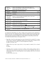
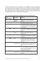
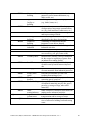
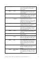
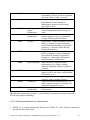
NB. A Note on Wellsites: Wellsites ≥ 0.5 ha in size (i.e. polygon features) do not require that the
wellhead and other infrastructures located therein be captured as separate point features. Rather,
an appropriate infrastructure type (e.g. MIWL or CIWL) can be used in the wellsite polygon
attributes to indicate the presence of a wellhead, and if present, other infrastuctures. However,
wellsites < 0.5 ha in size (e.g. as found in the White Area) should be represented using a multipoint feature, and attributed accordingly.
4.2.5.3
Linear infrastructures
Linear infrastructures include cutlines, trails, roads, railways, pipelines, and powerlines. The
following specifications apply:
•
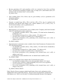
Branching linear infrastructures should be split into separate ABMI_LINE features:
o if there is a ≥ 5 m difference between the width of parent and child branches; or
o in roads, if the surface type differs between the child and the parent branches; or
o in cutlines and trails, if the child or parent branch is not maintained or is being reclaimed
while the other is not.
•
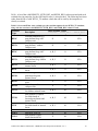
The width of those linear infrastructure features represented as lines is measured as follows:
o Roads: from edge of gravel (or pavement, dirt, etc.) to the other edge (thus the ditch, if
present, is not counted);
o Seismic cutlines and trails: from edge of clearing to edge of clearing, or edge of dirt (i.e.
visibly worn surface) to edge of dirt, as the case may be.
o Railways: from the foot of the gravel slope to the foot of the opposite slope (or the
farthermost slope, if there is more than one rail line).
o Transmission lines and pipelines: distance between the farthermost apart cables or pipes
(or pipe width, if there is only one), if visible or inferable (if not, leave blank); or when
the corridor along which the line runs is narrower than 20 m, the width of the corridor.
NB. See section 4.2.7.1 below – Anthropogenic corridors – for more detail regarding delineation
of these features.
4.2.6.3
Cities and Towns
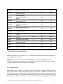
Cities and towns large enough to occupy a large portion (≥ 40%) or all of a photo-plot should be
delineated according to the following specifications:
Castilla, Hird, Maynes, McDermid – ABMI Photo-Plot Interpretation Manual, v2.4.1
45