1
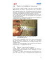
Sustainable Management of Natural
Resources in Central Vietnam
SMNR-CV
Mission Report
Participatory Forest Inventory
Pilot Implementation for MARD Circular 38
Field Experience in Quang Binh Province
Dr. Björn Wode
August 2008
____________________________________________________________
1
ACKNOWLEDGEMENTS
The consultant would like to express his gratitude to all project staff of the
SMNR-CV project for the kind support provided, especially Mr Nguyen Van
Hop, Forestry project staff and Mr Nguyen Minh Duc, project interpreter for
their constant support during the field and office work.
Special thanks to Mr Cao Xuan Chinh, Project Director, and Dr. HansJürgen Wiemer, Chief Technical Advisor, for providing me the opportunity
to conduct this mission in the SMNR-CV project.
Further thanks to Mr. Nguyen Viet Nhung and Mr Phung Van Bang from the
Forest Protection Sub-Department for very effective and open discussions
during the final de-briefing meeting.
I
____________________________________________________________
TABLE OF CONTENTS
1
ACKNOWLEDGEMENTS
I
2
EXECUTIVE SUMMARY
1
3
INTRODUCTION
2
4
PILOT IMPLEMENTATION
3
4.1
Preparation
3
4.2
Forest Blocking
4
4.3
GIS mapping database
4
4.4
Participatory Forest Inventory
6
4.5
Forest Inventory Database
6
4.6
Volume calculation
7
4.7
Documentation of Inventory Results
8
5
TRAINING EVALUATION
9
6
CONSIDERATIONS FOR PROVINCIAL APPLICATION
10
6.1
Proposed project support
11
II
____________________________________________________________
LIST OF ANNEXES
Annex 1:
Terms of Reference
Annex 2:
Mission Itinerary
Annex 3:
Overview of Forest Inventory Procedure
Annex 4:
GPS 60CS user guide
Annex 5:
MapInfo rough user guide
Annex 6:
DataFit user manual
Annex 7:
Forest Inventory Database
Annex 8:
Summary Table Circular 38
Annex 9:
Forest Inventory Results Dong Hoa
Annex 10: Summary Table Dong Hoa
Annex 11: Comments of DARD and DONRE in Quang Binh
LIST OF FIGURES
Figure 1:
Figure 2:
Figure 3:
Forest blocking and inventory design map overlaid on the
administrative three type of forest result map
5
Adjusted measure tape with scales for girth and colour
diameter classes
6
Extract from the commune forest inventory result map
showing forest area, forest status and forest vegetation
boundaries
8
III
____________________________________________________________
LIST OF ABBREVIATIONS AND ACRONYMS
CBFM
Community-based Forest Management
DARD
Province Department of Agriculture and Rural Development
Dbh
Diameter at breast height
DoNRE
Province Department of Natural Resources and Environment
FIPI
Forest Inventory and Planning Institute Vietnam
FLA
Forest Land Allocation
GIS
Geographic Information System
GoV
Government of Vietnam
GPS
Global Positioning System
GTZ
German Agency for Technical Cooperation
Ha
Hectare
KfW
MARD
Kreditanstalt für Wiederaufbau (German Financial
Cooperation)
Ministry of Agriculture and Rural Development
MoNRE
Ministry of Natural Resources and Environment
PLUP
Participatory Land Use Planning
PFCG
Provincial Forestry Consultative Group
Exchange rate: 1€ = 26.000 VND
IV
____________________________________________________________
2
EXECUTIVE SUMMARY
This consultancy has been designed as a follow-up mission on the
development of a technical concept and revised guideline for forest land
allocation in compliance with the legal policy frame as stipulated in Circular
38/2007/TT-BNN.
The mission was fielded in Tuyen Hoa for a period of seven days and
initiated a pilot on a combined forest inventory in Dong Hoa commune.
The combined inventory concept is designed to be jointly conducted by
technical staff and villagers and is intended to provide technically sound
data for a) the calculation of volume figures for the process of forest
allocation and b) the development of Village Forest Management Plans.
No technical difficulties have been encountered during the implementation
and forestland allocation planning procedures for a total forest area of 20
ha completed to the stage of a detailed description of forest characteristics.
Main results comprise (i) digital mapping information on the forest
vegetation cover and the forest inventory design, (ii) a comprehensive
forest inventory database, (iii) stand volume calculations based on a nonlinear regression analysis, and (iv) forest characteristics detailed in a
summary table as stipulated in Circular 38.
Illustrated guidelines and database formats for all planning steps have been
developed and applied during the training course which was conducted for
representatives from the provincial Forest Protection Sub-Department
(FPD) and Sub-Forest Inventory and Planning Institute (FIPI) ofQuang
Binh.
Participants have been trained in the use of GPS and GIS technology for
the production of digital mapping information on the current forest
vegetation cover during several practical exercises and are evaluated as
being fully capable to independently replicate the concept in other areas.
Outcomes have been presented to representatives of the PFCG and have
received very positive feedback regarding the accuracy and ease of data
analysis.
However, the very high sample intensity as currently required by the Forest
Inventory and Planning Institute was revealed as the major obstacle in view
of a province-wide application and integration into existing administrative
procedures.
It was therefore agreed that the training outcomes will be forwarded to the
inter-ministerial working group under MoNRE and MARD as contribution to
the development of a revised Circular on forest land allocation with realistic
technical and cost norms that can be effectively applied by the
administration.
Future capacity building by the project is only considered for a concept that
is based on outcomes from the inter-ministerial working group and
identified as feasible concept for a province-wide application by the
administration.
1
____________________________________________________________
3
INTRODUCTION
The project on Sustainable Management of Natural Resources in Central
Vietnam (SMNR-CV) is implemented by the Provincial Peoples Committee
in the Province of Quang Binh province with assistance from the German
Technical Cooperation (GTZ) and the German Development Service
(DED).
As specified in the Operational Plan for 2008 under work area 3 on
community forestry, the Project is supporting the Provincial Forestry
Consultative Group (PFCG) in adjusting provincial guidelines on forestland
allocation in line with national GoV Circular 38/2007/TT-BNN.
This assignment was designed to embark on the initiation of a village pilot
under the PFCG following the recently adjusted manual on “Participatory
Land Use Planning and Forest Land Allocation” (PLUP-FLA, see project
consultants’ report 12/2007).
Results will further contribute to the development of a provincial guideline
on Community-based Forest Management (CBFM) under project activity
3.6, which is intended to be submitted for legal approval by end of the year.
The main tasks of the consultancy are defined as follows:
•
Prepare inventory tools and a comprehensive inventory database
(Excel format) for data collection, storage and analysis.
•
In close cooperation with a national service provider initiate a village
pilot on a forest inventory concept for natural forest resources as
stipulated in Circular 38. The inventory has to serve (i) the preparation
of a comprehensive forest management plan as basis for sustainable
forest utilisation, timber trading and benefit sharing and (ii) the
development of standing volume estimates required for administrative
forest land allocation procedures.
•
Provide on-the-job training on:
o
o
o
Participatory mapping and forest blocking by use of GPS and GIS
technology.
The concept on participatory forest inventory and initiate field
implementation.
The process of data analysis including the development of a
diameter height function and calculations of volume estimates for
the development of a village forestland allocation database.
Field implementation has been conducted in Tuyen Hoa district, Dong Hoa
commune, Dai Son village.
For detailed information about the Terms of Reference and the mission
itinerary please refer to Annex 1 & 2.
2
____________________________________________________________
4
PILOT IMPLEMENTATION
As part of the previous consultancy the existing project PLUP-FLA manual
was adjusted to the forest policy frame as defined in Circular 38/2007/TTBNN 1.
The new project guideline is providing clear guidance on administrative and
technical procedures on the process of PLUP-FLA, adjusted to the new
policy frame.
The aim of the pilot implementation was to conduct field training for
provincial and district forestry technicians in these new procedures and
comprised the following main technical steps:
1) Forest blocking of by use of GPS technology using GSP GARMIN
60CS hand receivers,
2) Preparation of forest vegetation mapping information based on
GIS technology using MapSource and MapInfo software packages,
3) Design and implementation of a comprehensive forest inventory
with full participation of local forest users,
4) Data entry and storage in a digital database in Excel format,
5) Non-linear regression analysis for the development of tree heightdiameter correlations based on the two-factor function by the
National Forest Inventory and Planning Institute Vietnam (FIPI),
6) Calculation of volume estimates for the process of forestland
allocation,
7) Production of GIS database on FLA results,
8) Documentation of forest inventory results.
A brief overview on main activities under each step and accompanied
project guidelines is provided in Annex 3.
Implementation results and gained field experiences are discussed in
further details in the following chapters.
4.1
Preparation
In preparation of the fieldwork, two sets of inventory tools have been
prepared by the consultant comprising adjusted girth measure tapes, 20m
ropes for plot demarcation, improvised slope correction tools, 30m measure
tapes and tally sheet formats for data collection.
The province administration kindly provided two GPS GARMIN 60CS hand
receivers as well as Blume-Leiss height measure tools to be used during
the training exercise.
Three illustrated guidelines on the use of GPS GARMIN 60CS, MapInfo
professional software and DataFit version 9.0.59 software have been
1 38/2007/TT-BNN, dated 25/04/2007 on guidelines for procedures for forest allocation,
forest rental and withdrawal to organisations, households, individuals and communities
3
____________________________________________________________
developed and applied during the pilot implementation and are provided in
Annex 4, 5 and 6 for further reference.
The guidelines are providing step-by-step guidance of all functions required
when applying a specific hard/software with attached screen shots for fast
reference during the real application.
It needs to be emphasised that the guidelines are not intended nor
sufficient to equip an untrained person with all required skills to
independently conduct forest inventories but are designed as reminder for
technicians who have already participated in a comprehensive training
exercise.
4.2
Forest Blocking
As pre-selected by the project technicians a natural forest patch of around
20 ha has been mapped by use of GPS technology.
Forest block boundaries have been defined as uniform forest vegetation
cover in terms of forest type and status. Block boundaries are not
considering forestry administrative boundaries (Forest units, compartments,
block) but strictly following the characteristics of the natural vegetation only,
as for each forest vegetation type a separate inventory has to be
conducted.
A total of 127 waypoints have been marked and entered into a GIS
database during the mapping exercise which comprised one day field work
only.
Intensive two-days training on the use of GPS devices (set-up of projection
and map datum, editing, marking and deleting waypoints, find functions,
map functions, downloading of waypoints) has been conducted including
practical outdoor and indoor exercises.
All functions as applied during the training are furthermore described in the
developed GPS 60CS user guideline in Annex 4 as reminder for coming
implementation.
4.3
GIS mapping database
Map production is based on Garmin MapSource software Trip and
Waypoint manager v4 and MapInfo v8.0 professional software. Technicians
and project staff have recently participated in a GIS training course and
therefore showed already good knowledge on main GIS functions.
Waypoints have been automatically downloaded into a GIS database by
use of MapSource software with help of the available project guideline.
Produced mapping information is detailing the shape, location and area per
forest block and its location in the existing mapping information provided by
the three types of forest result map.
Due to the use of different map projection systems of the legal mapping
information and the developed GIS database the identified forest block area
is dislocated by 200m (see figure 1), which however is not relevant for the
4
____________________________________________________________
forest inventory design and implementation as long as the GPS set-up is
kept unchanged.
Final result maps for FLA procedures are anyway to be produced by the
administration in VN2000 datum which would automatically correct this
distortion.
Developed mapping information is further depicting the inventory design in
form of a systematic grid net and the locations of all sample plots to be
measured.
200m
Figure 1: Forest blocking and inventory design map overlaid on
the administrative three type of forest result map
Following the national standard by FIPI a sample intensity of 2% was
applied which translates into a grid net distance of 130m between two
sample plots and a total number of 11 plots.
The detailed field survey later revealed two different forest types within the
forest block and an area of 7,84 ha had to be separated as independent
forest block and the total number of sample plots for the remaining area of
19,05 ha to be reduced to eight (sample plots no.4 -11).
5
____________________________________________________________
4.4
Participatory Forest Inventory
Forest inventory has been conducted by two teams consisting of project
staff, technicians from provincial and district level as well as local forest
users.
After a detailed introduction, two teams directly conducted measurements
without any technical difficulties encountered, underlying the practicability
of the proposed concept in terms of available capacities at field level.
A total of eight sample plots have been measured by two teams within one
day confirming field experiences from other provinces with an average of
around five plots/team/day.
Tree measurements are conducted by use of a girth measure tape with an
additional colour scale attached to it (see figure 2).
Figure 2: Adjusted measure tape with scales for girth and
colour diameter classes
The girth scale is used to obtain precise data for volume estimates during
the forestland allocation process while the colour scale is describing
diameter classes for the development of sustainable smallholder forest
management plans.
Local forest users were responsible for tree measurements and showed to
be very confident in using the adjusted girth tape.
4.5
Forest Inventory Database
In order to ease the process of data compilation and analysis, a
comprehensive inventory databank has been developed using Excel
software (see Annex 7).
The databank only requires the input of the total forest area, plot ID, tree
name, girth, quality and height. All forest characteristics required for the
6
____________________________________________________________
forest land allocation (volume, basal area, stem number, average tree
height, average diameter) are automatically calculated by Excel.
Furthermore, stem number and volume distribution per diameter class is
shown in form of a column chart and provides all required information for
the process of forest management planning by communities (see Annex 9).
Data entry has been completed for all eight sample plots and required less
than one hour during the training exercise.
4.6
Volume calculation
Due to the absence of tree specific diameter-height functions2 and form
factors per tree species for the project region, a general volume function
had to be developed based on the inventory results.
As stipulated in Circular 38 the logarithmic equation from the FIPI was
applied as described below:
A+B*LnD
H = 2,718282
1.3
Whereas: H = Tree height
A, B = Variables A, B
LnD1.3 = Logarithmic diameter at Dbh
A non-linear regression analysis was conducted by use of DataFit version
9.0.59 software following the developed guideline (see Annex 6).
Participants were immediately capable to independently conduct the
calculation by following the provided guideline and a regression was
completed within 20 minutes only .
However, due to the very limited number of only 96 tree height
measurements as conducted during the training exercise no plausible
results could be obtained and instead regression results from similar forest
types in Quang Ngai province have been temporarily used instead3.
It is estimated that a total of at least 500 tree height measurements (~160
sample plots with three tree height measurements per plot) are required to
gain statistically significant results for a specific forest type.
The values for the equation factors A and B were then entered into the
Excel databank and volume figures automatically calculated from the
inventory data.
With a calculated volume of 113m³/ha and a basal area of 15,1m²/ha the
forest status was identified as IIIa2, a so-called medium, previously
exploited forest4.
2 see Forestry Inventory Hand Book, 1995 by FIPI for further details
3 A total of 665 tree height measurements have been obtained during a forest inventory in
2007 in the frame of a CFM pilot under the KfW 6 project.
4 IIIa2: Medium forest (standing stock 80-150m³, basal area 11-15m²) following the national
forest classification standard as stipulated in Decision 684/QD and QP N6-84 of MARD
dated 1 August, 1994
7
____________________________________________________________
4.7
Documentation of Inventory Results
As part of the final documentation a result map is attached to the final
report depicting forest areas and forest status per forest block.
As this result map forms the basis for legal forestland allocation, forest
block boundaries as delineated during forest blocking have to be integrated
into the forest administrative system (Forest units, compartments, block)
and if required divided accordingly.
For the training exercise the entire forest block was inside one forest unit
and compartment and therefore did not require any further adjustments.
Inventory analysis results were finally compiled into a summary table form
(see Annex 10) following the format provided in Annex 8 or as attached to
the PLUP-FLA guideline. The table is part of the formal report on the
implementation results to be compiled by the consulting organisation in
preparation of the forest land allocation appraisal mission.
Figure 3: Extract from the commune forest inventory result
map showing forest area, forest status and forest
vegetation boundaries
8
____________________________________________________________
5
TRAINING EVALUATION
During a period of seven days in Tuyen Hoa district, provincial and district
level technicians as well as project staff have been exposed to all
procedures required to complete a comprehensive forest inventory required
for forest land allocation as stipulated in Circular 38.
Despite several interruptions due to district-wide power cuts all exercises
have been completed as planned and training results documented as
provided in several Annexes of this report.
No major difficulties were encountered during field implementation and
participants from various levels proved to be capable to independently
conduct forest inventories right away after a brief introduction only.
Local people actively participated during sample lot layout and actual data
collection under supervision of a provincial technician to ensure strict
compliance with the technical guideline and the quality of produced data.
Based on the field exercise time requirements for GPS mapping
procedures are estimated at around 30-40ha/day /team.
Forest inventory, despite being conducted in a rather difficult terrain with
extreme slopes of up to 70%, was completed during one day with a total of
8 sample plots measured by two independent groups. For future
implementation an average of 4-5 sample plots/day/team is therefore
considered feasible during real implementation. Similar experiences have
been gained during pilot implementation of forest inventories in Quang Ngai
province.
Participants from Sub-FIPI and the Forest Protection Sub-Department of
Quang Binh province have been trained in GPS/GIS technology during
repeated practical exercises and are evaluated as fully capable to
independently continue piloting of forestland allocation procedures under
the PFCG.
Developed guidelines have provided crucial guidance during the process of
data analysis and have been further adjusted based on the training
experiences.
Time requirements for indoor data entry and analysis mainly depend on
the number of different forest types to be distinguished during the final
reporting and mapping. As a conservative estimate, an area of 500ha with
10 distinct forest blocks should be feasible within 2 days.
In conclusion, the proposed technical concept in strict compliance with
Circular 38 has proven technically feasible at a pilot scale and well within
the available capacities of potential service providers to independently
continue piloting after this training course.
However, in view of a province-wide application a number of crucial
prerequisites are discussed in the following chapter.
9
____________________________________________________________
6
CONSIDERATIONS FOR
PROVINCIAL APPLICATION
The project has committed itself to contribute to the development of a
participatory and technically sound procedure for the implementation of
Circular 38 to become an integrated part of the provincial master plan of
“Forest allocation and leasing for the period 2007 – 2010” of Quang Binh
province.
In addition, an inter-ministerial working group under MoNRE and MARD is
operational since June 2008, embarking on the adjustment on forest land
allocation procedures and specifically on the revision of technical
procedures as detailed in Circular 38.
Field experiences as gained during this assignment are of crucial
importance for both above mentioned processes, to ensure that developed
technical and cost norms will be applicable in the field.
Training outcomes have been discussed with Mr Nguyen Viet Nhung and
Mr Phung Van Bang from the Forest Protection Sub-Department in their
function as members of the PFCG and have been highly appreciated
regarding the accuracy and ease of data analysis.
Pilot results have demonstrated the technical feasibility of the proposed
concept on a pilot scale in strict compliance with the legal frame as defined
by Circular 38.
A package of all available guidelines and databases was further requested
by the Sub-Department to be used during training of forest rangers in the
new inventory concept.
However, the very high sample intensity5 as required by FIPI is revealed as
the major obstacle in view of a province-wide application and integration
into existing administrative procedures.
Instructions as provided by the FIPI with 2% sample intensity are by far
exceeding the required level of accuracy needed, while Circular 38 on the
other hand is too ambiguous and not providing sufficient guidance
regarding this matter.
It was therefore jointly agreed that:
Experiences from the pilot result should be provided to the interministerial working group to derive at realistic technical and cost
norms that can be effectively applied by the administration.
Clear procedures and benchmarks for sample intensities for the
process of a) forest land allocation and b) repeated forest
management inventories are to be defined and approved as legal
procedure.
Further capacity building measures will only be provided by the
project for a technical concept that is based on outcomes from the
5 Percentage of the total surveyed forest area to be covered by sample plots. Currently
defined with 2% according to Forest Inventory and Planning Institute Vietnam
10
____________________________________________________________
inter-ministerial working group and identified as feasible concept for
a province-wide application by the administration.
Forestland allocation is given high priority by the provincial forestry
line departments and is requested to be considered accordingly in
the budget allocation for 2009. This even implies budget reallocation
from other planned forestry activities considered less crucial.
Forest inventory could further be tested as valuable input data for
the process of forest valuation, a topic which is still under discussion
at national level.
6.1
Proposed project support
Following the above discussed pilot outcomes it is considered of crucial
importance to timely provide sufficient information in terms of technical
guidelines and pilot training results to the GTZ Forestry Program Vietnam
to be forwarded to respective members of the inter-ministerial working
group.
Furthermore, a Vietnamese fourth draft of a technical cost norm was
circulated to projects for comments and should be commented by the
PFCG and the project as a joint statement for Quang Binh province.
Following the meeting with the FPD a full documentation of the pilot
outcomes was requested and is seen as a very positive signal for the
strong interest from the provincial authorities in the approach and is
providing a good opportunity to receive detailed feedback on the piloted
concept.
Finally, it has to be emphasised that balancing ease of implementation
versus accuracy has to safeguard that planning outcomes will still provide
sufficient data for operational level planning for village forest management.
A too low sample intensity would only generate data similarly to the already
existing national forest inventory as conducted by FIPI which can be used
at strategic national level only.
11
____________________________________________________________
ANNEX 1: TERMS OF REFERENCE
Sustainable Management of Natural Resources in Central Vietnam (SMNR-CV)
Short-term Assignment: Work Area 3 “Community Forestry”
Consultant: Björn Wode
1. Background information
The project on Sustainable Management of Natural Resources in Central Vietnam
(SMNR-CV) is implemented by the Provincial Peoples Committee (PPC) in the
Province of Quang Binh with assistance of the German Technical Cooperation
(GTZ) and the German Development Service (DED). Its overall objective is that the
stakeholders in the project region manage their natural resources in a sustainable
way. The implementation of project interventions is structured into three work areas:
I. Decentralized Planning (LED/ Participatory SEDP/CDP)
II. Participatory Agricultural Extension (PAEM) and Value Chain Promotion
III. Community Forestry (FPDR, PLUP-FLA, CBFM)
2. Objectives of the assignment:
The present short term assignment is designed to assist Quang Binh province in the
pilot implementation of a forest resource assessment for the process of allocation of
existing natural forest resources to the local population as stipulated in the new
MARD Circular No. 38/2007/TT-BTT dated 25 April 2007.
Specific tasks:
Based on the recently adjusted project PLUP-FLA guideline initiate the
implementation of a village pilot under the Provincial Community Forestry Working
group.
Prepare inventory measure tools and a comprehensive inventory database (Excel
format) for data collection, storage and analysis.
In close cooperation with a national service provider (to be selected by Provincial
Line Departments) develop an inventory design for the assessment of existing
forest resources following the technical concept as stipulated in Circular 38.
The inventory has to serve the collection of data for (i) the preparation of a
comprehensive forest management plan as basis for sustainable forest
utilisation, timber trading and benefit sharing and (ii) the development of
standing volume estimates required for land allocation database according to
Circular No. 38. This combined inventory concept is considered crucial to
avoid a duplication of inventory fieldwork activities after the process of FLA in
view of CFM planning procedures and for a legalisation of CFM planning data.
Provide field training on participatory mapping and forest blocking by use of GPS
and GIS technology.
Provide training on the concept on participatory forest inventory and initiate field
implementation.
Provide training on the process of data analysis including the development of
diameter height function and calculations of volume estimates for the
development of a village land allocation database.
1
____________________________________________________________
Document preliminary results in a brief mission report (10-15 pages) and present
final mission results to the Provincial Community Forestry Working Group.
3. Required preparations prior to the mission:
Selection of a suitable pilot village with natural forest resources (IIa and above)
having standing volume to be allocated to the local population classified as
production forest.
Measurement equipment (GPS V Garmin hand receiver, Blume Leiss height
measure tool) and mapping information (hard and soft copy of forest
vegetation cover map, forest land use planning map at a scale of 1:10.000 all
in UTM datum) is made available.
Local service provider identified and available during the entire time of the
assignment
4. Reporting deadline
Presentation of preliminary results by end of the field assignment
Brief mission report (10-15 pages) 10 days after completion of field mission
5. Time schedule and total input days
The assignment is scheduled for 14 days including preparation, reporting and travel
to and from Quang Binh. Fieldwork in Quang Binh is intended to start on
15/07/2008. The consultant is expected to conduct a follow-up mission (14 days) by
October/November 2008.
2
____________________________________________________________
ANNEX 2: MISSION ITINERARY
Period: 16/07/2008 – 29/07/2008
DAY & DATE
Wed,
-Fri,
16-18/07
LOCATION AND TASK
Meeting with project staff; Preparation of inventory equipment,
database and manuals
Sat,
19/07
Travel to Tuyen Hoa; preparatory meeting with project staff
Sun,
20/07
Outdoor forest blocking by use of GPS device
Mon,
21/07
Forest inventory Dong Hoa commune, Dai Son village
Tue,
22/07
Data entry Dong Hoa commune; presentation of CFM concept
Wed,
-Fri,
23-25/07
GPS training outdoor; data analysis indoor; return to Dong Hoi
town
Sat,Sun
Mon,
26-27/07
Development of technical guidlines
28/07
Report writing
Tue,
29/07
Meeting at provincial forest protection department ; Travel to
Hanoi
1
____________________________________________________________
ANNEX 3:
Overview of main procedures during implementation of forest
inventories following Circular 38/2007/TT-BNN
Step 1: Forest blocking and GPS ground-truthing
Description:
Preparation for forest inventories requires accurate data on area (ha) and current
forest vegetation cover.
For each forest type (dry Dipterocarp forest, evergreen forest, afforestation etc.) and
status (IIIa2, IIa, etc.) a separate inventory and data analysis needs to be conducted.
Forest blocks with uniform forest type and status have to be identified in the field and
marked by use of GPS technology.
Identified forest blocks may have different size and borderlines than management
boundaries (Tieu Khu, Khoang, Lo) as defined by the forest administration.
Equipment:
Three types of forest result map, Garmin GPS hand receiver
Guideline:
GPS 60 CS user manual
Step 2:
GIS map production
Description:
Collected GPS data is converted into a GIS database for production of digital forest
vegetation cover maps.
MapSource software is required to automatically download GPS waypoints via an
USB interface cable to the PC. The software is furthermore providing pre-installed
maps for a first re-check of the fieldwork results.
Map production is conducted by use of MapInfo professional software in which
waypoints are connected to polygons for area calculation and finally added to the
existing forest status map from the administration as additional layer of existing forest
vegetation cover.
Equipment:
Garmin MapSource software Trip and Waypoint manager v4, Garmin GPS hand
receiver, USB Interface Cable, MapInfo software, PC, GIS database 3 types of forest
result map
Guideline:
MapSource user guide, MapInfo rough user guide
1
____________________________________________________________
Step 3: Forest inventory design
Description:
After forest blocks have been identified and mapped the forest inventory is designed
in form of a systematic grid net overlaid on the forest block GIS database.
Required number of sample plots and grid net width is calculated by the provided
Excel database “Forest Inventory Results” and is depending on the desired sample
intensity and total forest block area.
A digital grid net is added to the GIS database and the sample plot locations
recorded and uploaded to the GPS deceive.
A print-out or copy from the screen on a transparency is required for better
orientation during the field implementation.
Equipment:
Garmin MapSource software Trip and Waypoint manager v4, Garmin GPS hand
receiver, USB Interface Cable, MapInfo software, PC, Excel database
Guideline:
MapInfo rough user guide
Step 4: Forest inventory
Description:
Inventory equipment needs to be prepared including slope measure tool, adjusted
girth measure tape, plot demarcation ropes, and tally sheets.
One measure team consists of at least one technician and two local forest users.
Sample plots comprise an area of 500m² in which all trees > 8cm dbh are measured.
Tree height measurements are limited to three trees per sample plot.
On average five sample plots/day/team can be completed.
Equipment:
GPS hand receiver, slope measure tool, adjusted girth measure tape, tree height
measure tool, plot demarcation ropes, 30m measure tape, tally sheets, oil paint, chalk
Guideline:
PLUP-FLA guideline
2
____________________________________________________________
Step 5: Forest inventory data analysis
Description:
Obtained tally sheet data (species, girth, quality class, height) is entered into the
Excel database.
Volume calculation is based on a diameter height correlation, which is derived from a
non-linear regression using DataFit software. DataFit is a software that simplifies
regression analysis (curve fitting) and statistical analysis.
As defined in Circular 38/2007/TT-BNN the two factor logarithmic equation from FIPI
has to be used as standard.
Regression results (variable a and b) are copied back into the Excel database for
volume calculation.
Equipment:
Filled tally sheets, Excel database, DataFit version 9.0.59 software, D_H_Regression,
PC
Guideline:
DataFit user guide
Step 6: Result map production
Description:
The final result map for forestland allocation has to define areas per forest status
following forestry administrative boundaries (Tieu khu, Khoang, Lo). Therefore, forest
block areas as used during the forest inventory might have to be adjusted accordingly.
The result map in MapInfo defines forest status, volume and area following forestry
administrative boundaries. In addition, one layer has to define the forest inventory
design to allow the appraisal mission to re-check individual plots before approving
inventory results.
Equipment:
MapInfo software, PC, Excel worksheet “Forest Inventory Results”
Guideline:
MapInfo rough user guide
Step 7: Summary table on forest characteristics
Description:
Forest characteristics for a specific commune are documented in a summary table
form as stipulated in Circular 38.
Definition of forest status as defined by volume and basal area is given in the Excel
sheet “forest status”.
Equipment:
PC, Excel worksheet “Summary Table Form Circular 38”
Guideline: -
3
____________________________________________________________
ANNEX 4: GPS 60CS USER INSTRUCTIONS
1
On/Off
Press and hold to turn GPS on
and off
2
Rocker
key
Move up/down or right/left to move
through lists or on the map
3
PAGE
Switches between pages. Press
and hold to switch between
landscape and portrait screen
display
4
MENU
Displays available options for the
current page. Press twice to come
to main menu
5
ENTER To confirm
option.
6
ZOOM
In the Map page press to zoom in
or out
7
FIND
To search for waypoints
8
MARK
Press to mark current location as
waypoint
9
QUIT
Returns to the previous selection
a
selected
menu
1
____________________________________________________________
START GPS UNIT
The GPS hand receiver can only detect the current location if
used outdoor.
Try to avoid using the GPS on days with dark cloudy sky as
this might effect the accuracy of the measurement.
To start the GPS press and hold the POWER key until the
satellite page will appear.
The GPS is now automatically searching for satellites.
This is the main GPS page and can be displayed at any time
by repeatedly pressing PAGE.
To turn of the GPS press and hold the POWER key again until
the screen is empty.
2
____________________________________________________________
MAIN MENU / SETUP
To change the setting of the GPS press
MENU twice. The MAIN MENU page appears.
Use the rocker key to scroll to SETUP (1).
Confirm by pressing ENTER.
1
2
On SETUP MENU page scroll to UNITS (2).
Confirm by pressing enter.
3
____________________________________________________________
UNITS SETUP
3
Scroll down to POSITION FORMAT to change between UTM
or VN2000 map datum.
VN 2000 has to be defined as USER and requires a number of
parameters.
4
For UTM datum define POSITION FORMAT as UTM by pressing
menu and confirm by pressing enter (3).
Scroll down to MAP DATUM and set it to WGS 84.
Press QUIT repeatedly to leave the Setup until the satellite page
appears.
4
____________________________________________________________
MARK WAYPOINT
Press MARK and the MARK WAYPOINT page appears showing
the number of the waypoint and its coordinates.
Press ENTER to confirm.
(The OK sign has to be in yellow colour to mark a waypoint)
The GPS will automatically store the waypoint and by pressing
MARK again a new waypoint will be added to the list.
FIND WAYPOINT
For the location of inventory
5
sample plots, waypoints have to
be located in the field again.
6
To find a waypoint press FIND
and scroll to WAYPOINTS (5).
Press enter and a menu page
appears. Press ENTER to confirm
selection FIND BY NAME (6).
The list of waypoints is displayed and
number of the desired waypoint can be
entered in the top row by selecting
numbers and letters from the menu or by
directly pressing OK and scrolling down to
the desired number by using the rocker
key (7).
After the waypoint has been selected scroll
to the option GO TO and press enter to
confirm.
7
5
____________________________________________________________
On the map page use the rocker key to position the white
map pointer (8) on a map item to determine the distance
from your current position. The distance is shown at the
top right bar (9).
9
In the provided example the distance is 10m towards
North direction.
The pink line shows the direction from the current position
to the desired waypoint (waypoint no. 2 as shown in the
picture).
The black arrow shows the current walking direction from
the current location towards the desired waypoint.
8
6
____________________________________________________________
DOWNLOAD WAYPOINTS
The GPS is equipped with two ports
(under protection weather cover) for
automatic download of waypoints into
MapSource data files:
USB
Connector
Port
Serial Port
Data
Cable
Protection
weather
cover
Protection
weather
cover
1) USB Connector Port
2) Serial Port Data Cable
Both ports can be used to
automatically
down/upload
waypoints to/from MapSource.
7
____________________________________________________________
ANNEX 5: Rough guide for the development of basic intervention area maps using
MapInfo Professional software
After starting the application MapInfo professional
press “Cancel” in the shown window “Quick Start”.
Click “File” in the
Menubar and
press “open” to
work on a map
from the
respective folder
or select “new
table…” to create
a new table.
Two Button pads “Main” and “Drawings” appear at
the left side of the main window.
Pointer to select a waypoint, view and edit its location
Zooming in and out of the map in the window
Grasper to move map in any direction
Information to see and edit information of waypoint
Layer control to make map editable or add new layers
Symbol to add waypoints in the map
Polyline to link waypoints e.g. river or street
Polyline to define an area
Add text into the map
1
____________________________________________________________
Before start working on a map, the map options
have to be defined.
Press “Map“ in the Menu bar and select
“Options...“ to open the window “Map options“.
Define Map Units from top to bottom by scrolling
down the provided options as shown in the
picture:
Coordinate Units: Degrees
Distance Unit: meters
Area Unit: hectares
To select the map projection press
“Projection…” and select:
Category: Universal Transverse Mercator
(WGS 84)
Category Members: UTM Zone 48. Northern
Hemisphere (WGS 84)
Press “OK” to confirm
2
____________________________________________________________
A map can only be adjusted if
the respective layer has been
marked as editable.
Click on the layer control
button in the Button pad
“Main” as indicated by arrow 1.
Mark the respective layer with
a tick under the pencil symbol
in the “Layer Control” window
as indicated by arrow 2.
2
1
Press “OK” to close the
window.
To add a waypoint into a map select
the Symbol
in the Button pad
“Drawing” as indicated by arrow 1.
Click on a position in the map to set a
waypoint.
in the Button
Select the Symbol
pad “Main” (arrow 2). Click on the
waypoint on the map. The “Info Tool”
window is opened and the name of the
waypoint can be entered. After the
name has been entered, close the
“Info Tool” window.
Select the Pointer
in the Button
pad “Main” as indicated by arrow 1.
Double click on the selected waypoint
to see the coordinates in the window
“Point Object”.
Waypoint coordinates can be directly
adjusted by typing in the window. After
pressing “OK” the waypoint will
automatically move into the correct
position on the map.
1
2
1
3
____________________________________________________________
To draw a polygon and calculate an area, select
in the button pad “Drawing” as
the pointer
indicated by arrow 2.
Press “S” on your keyboard to activate the snap
function, which will be indicated at the bottom of
the window as indicated by arrow 2.
1
Start at the first waypoint until the symbol of a
cross appears. Click once to confirm and move
to the next point and so on until you close the
lines to a completed “polygon”.
2
After the polygon has
been completed, select
the pointer
in the
button pad “Main” as
indicated by arrow 1.
Double click inside the
selected area or
polygon.
The area of the polygon
is shown in the “Region
Object” window under
the coordinates e.g.
1,479 hectares (see
arrow 2).
1
2
3
The perimeter or walking distance around the area is given below the
area figure indicated by arrow 3, e.g. 464,9 meters
To create a new table or new
layer to be placed on top of the
GPS points for the description of
inventory grid nets or sample
plots etc. select “file” in the
menu and select “new table..”
4
____________________________________________________________
Add the table to the current mapper
and name the table according to the
information to be provided in the table
e.g. gridnet, sampleplots etc.
You will be asked two times to first
name and second to name and save
the new table.
Remember that layers can only be
edited if they are made “editable”.
Open “Layer Control” and tick the
respective field under the pencil symbol.
Then press ok and start working on the
layer selected.
To create a grid net for the location of the forest
inventory sample plots select “tools” in the menu and
go to “tool manager…”.
Scroll down and select “Grid Maker”
click Loaded and Autoload to ensure
that during coming sessions the grid
maker is preinstalled.
Press “OK” to confirm.
5
____________________________________________________________
A button pad named “Tools” automatically
appears. Select the grid net symbol “create
grid” (see arrow 1).
Mark the entire area to be covered by the grid
net.
1
The window “grid maker” will open automatically. In
the grid maker window, select “meter” in the scroll
bar and enter the grid net width (the distance
between two sample plots, see arrow 1) in the
window and press “ok”.
Under “New Table:” the location were the table will
be stored can be selected, always place it in the
folder with the other existing tables (see arrow 2).
The grid net appears in your map and is
automatically added as a new table to the existing
map.
1
2
Grid net points define the area where a sample plot
will be located in the forest during the forest
inventory.
The location of each sample plot ( ) has to be
added into a table on top of the existing grid net table
by placing new points by hand into the table.
The location of each sample plot can then either be
copied into the GPS by hand or the entire sample
plot table uploaded into GPS by use of MapSource.
6
____________________________________________________________
To change the style of the
polygon and waypoints double
click on the polygon and press
“Style” in the “Region Object”
window.
Scroll down and select different
patterns, foregrounds and
border styles.
Select a grid net or line “Pattern”
and disable the “Background” to
create a semi-transparent to
ensure that mapping features
(rivers, contour lines etc.) under
the polygon will still be visible in
the final result map.
Press “OK” to confirm the
selected style.
Remember, only if the table is
made editable in the layer
control window the style can be
changed.
Always define forest blocks as semitransparent polygon to still be able to see
the information provided below it.
Example of a semi-transparent polygon
overlaid on existing mapping information
showing forest status and road network
below.
To save the created map click on the floppy
disk button
in the menu bar and click
“Save” to confirm.
In case more than one table is opened all
tables have to be saved separately.
Note: This handout is not intended or sufficient to equip an untrained person with all required skills to
independently develop digital mapping information based on GPS field data.
The procedure as described above is designed to develop basic information on the form and area of
forest blocks, which have been identified through GPS ground-truthing in the field.
This manual is based on samples from the KfW 6 project, the GTZ RDDL project and the ADB FLITCH
project. The kind permission to utilise the samples and adjust it to the context of PLUP-PFLA in Quang
Binh province is herewith acknowledged.
7
____________________________________________________________
ANNEX 6: DataFit rough user guide for non-linear regression analysis
To conduct a regression analysis the following data is
required:
Raw data (diameter [x] and height measurements [y])
stored in Excel worksheet
File “D_H_Regression.dft” (contains the pre-defined
two-factor non-logarithmic diameter height function from
the Forest Inventory and Planning Institute).
To conduct a regression start DataFit and select “File” and
“Open…” in the Main Menu.
A new window appears
in which you have to
browse for the file “D_H_ Regression.dft”.
Select the file and click
“Open”.
Never change or
overwrite this file
name!
An empty
table format
with “x” and
“y” appears
in which the
raw data
from the
Excel sheet
has to be
entered.
Raw data
has to
contain
diameter in
the first (x)
column and
height in the
second (y).
1
____________________________________________________________
Copy all raw data from the
excel sheet and paste the
data by right mouse click
into the table.
Entered data appears in the table
form and can be checked and edited
in this table if required.
2
____________________________________________________________
The program is now equipped with
sufficient data to run a regression
analysis.
Select “Solve” in the main menu,
select “Regression” or simply press
F4 to define the regression set-up.
The Solution set-up window appears.
Ensure that “Single Model” is selected and
choose below the option “NonLinear”.
Press “OK” to confirm.
3
____________________________________________________________
The Single Model Regression
Setup appears.
Select “User-defined models” and the
“FIPI Vietnam” function will appear in
the window. The function name has to
appear on a blue background after
selecting it.
To start the calculation press
at the bottom of the window.
After the calculation a window appears confirming that the regression has
been completed successfully.
Press “ok” to confirm.
To view the regression results select “Results”
from the main menu and scroll down to
“Detailed…” or simply press F5.
4
____________________________________________________________
The results are shown in form of a
table detailing all available statistical
parameters.
Most important is the Coefficient of
Multiple Determination (R^2), which
should always have a value clearly
above 0,5.
Values of close to or below 0,5 do
not show a significant correlation
between diameter and tree height
and can therefore not be used for
stand volume calculations.
Scroll down to “Regression Variable Results”
and see the values for variables “a” and “b”
to be later entered into the “Forest inventory
results.xls” Excel sheet.
A graphic presentation
of the regression results
is provided under “Model
Plot” in the top menu.
The graphic is an
effective way to roughly
check the plausibility of
the regression results
and should be a rising
curve similar to the
shown in the picture to
the right.
The curve should show
a decrease in increment
towards the higher end
as the height growth of
bigger trees decreases
as well.
5
____________________________________________________________
Copy the values for variable “a” and “b” into the Excel sheet “Analysis volume function” to calculate the
stand volume.
Note: A free trial version for 30 days can be downloaded under:
http://www.newfreedownloads.com/Software-Developer/Active-X/DataFit.html
6
____________________________________________________________
Annex 7: Forest Inventory Database
(Extracts from EXCEL files)
Data input - Inventory results
District
Commune
Village
Forest Block
Block size [ha]
# Plot
Species
Girth
Quality
Height
1
2
3
4
5
Regression Data
Diameter
Height
0,0
0,0
0,0
0,0
0,0
0,0
0,0
0,0
0,0
0,0
0,0
0,0
0,0
0,0
0,0
0,0
0
0
0
0
0
0
0
0
0
0
0
0
0
0
0
0
Datafit database
►Mark both columns F and G
►Select "Data" from the main menu, click "Sort..."
►Select "Sort by" Height, click descending
►Copy all trees with height measurements into Datafit
1
____________________________________________________________
Ready-made print-out format, do not overwrite any information in this worksheet!
District
Commune
0
Village
0
Forest block
0
0
5
6
7
8
9
10
11
12
13
14
15
16
17
18
19
20
21
22
23
24
25
Stem
number
Stem
number
Stem
number
Stem
number
Stem
number
Stem
number
Stem
number
Stem
number
Stem
number
Stem
number
Stem
number
Stem
number
4
Volume
> 65 cm
diameter class
Volume
60-64,9 cm
diameter class
Volume
55-59,9 cm
diameter class
Volume
50-54,9 cm
diameter class
Volume
45-49,9 cm
diameter class
Volume
40-44,9 cm
diameter class
Volume
35-39,9 cm
diameter class
Volume
30-34,9 cm
diameter class
Volume
25-29,9 cm
diameter class
Volume
20-24,9 cm
diameter class
Volume
15-19,9 cm
diameter class
Volume
08-14,9 cm
diameter class
24
25
#DIV/0! #DIV/0! #DIV/0! #DIV/0! ##### #DIV/0! ##### ##### ##### #DIV/0! ##### #DIV/0! ##### ##### ##### #DIV/0! #DIV/0! #DIV/0! #DIV/0! #DIV/0! #DIV/0! #DIV/0! #DIV/0! #DIV/0!
N/ha
Max. Class
#DIV/0! #DIV/0! ##### #DIV/0! ##### ##### #####
14,9
19,9
24,9
29,9
34,9
44,9
>45
Hectare figures (ha)
Stem number [ha]
#DIV/0!
Volume [ha]
#DIV/0!
Basal area [m²]
#DIV/0!
Stand figures (block)
Block size [ha]
0
Sample plots [#]
0
Average diameter [cm]
#DIV/0!
Average height [m]
#DIV/0!
Stem number [block]
#DIV/0!
Volume [block]
#DIV/0!
1
____________________________________________________________
Ready-made print-out format, do not overwrite any information in this worksheet!
District
Commune
0
Village
0
Forest block
0
0
2
3
4
5
6
N/ha
Max. Class
7
8
9
#####
#DIV/0!
#DIV/0!
10
11
12
13
14
15
16
17
18
19
20
21
22
Stem
number
Stem
number
Stem
number
Stem
number
Stem
number
Stem
number
Stem
number
Stem
number
Stem
number
Stem
number
Stem
number
Stem
number
1
#DIV/0! #DIV/0! #DIV/0! #DIV/0! #DIV/0! #DIV/0!
Volume
> 65 cm
diameter class
Volume
60-64,9 cm
diameter class
Volume
55-59,9 cm
diameter class
Volume
50-54,9 cm
diameter class
Volume
45-49,9 cm
diameter class
Volume
40-44,9 cm
diameter class
Volume
35-39,9 cm
diameter class
Volume
30-34,9 cm
diameter class
Volume
25-29,9 cm
diameter class
Volume
20-24,9 cm
diameter class
Volume
15-19,9 cm
diameter class
Volume
08-14,9 cm
diameter class
23
24
#DIV/0! ##### #DIV/0! ##### #DIV/0! ##### #DIV/0! #DIV/0! #DIV/0! #DIV/0! #DIV/0! #DIV/0! #DIV/0! #DIV/0! #DIV/0!
#DIV/0! #DIV/0! #DIV/0! #DIV/0! ##### #DIV/0! #DIV/0!
14,9
19,9
24,9
29,9
34,9
44,9
>45
Hectare figures (ha)
Stem number [ha]
#DIV/0!
Volume [ha]
#DIV/0!
Basal area [m²]
#DIV/0!
1
1
Stem number [ha]
1
1
Stand figures (block)
Block size [ha]
0
Sample plots [#]
0
Average diameter [cm]
#DIV/0!
Average height [m]
#DIV/0!
Stem number [block]
#DIV/0!
Volume [block]
#DIV/0!
1
1
0
0
0
0
0
14,9
19,9
24,9
29,9
34,9
Max. class diameter
44,9
>45
Y=
A=
B=
Volume equation
e^ln(a)+b*ln(x)
2
____________________________________________________________
Height measurements per diameter class
Number of tree
heights
Diameter
class
Girth
0
0
0
0
0
0
0
0
0
0
0
0
0
0
0
0
0
0
0
0
0
0
0
0
0
0
8-10
10-12
12-14
14-16
16-18
18-20
20-22
22-24
24-26
26-28
28-30
30-32
32-34
34-36
36-38
38-40
40-42
42-44
44-46
46-48
48-50
50-52
52-54
54-56
56-58
58-60
25-31
31-37
37-44
44-50
50-56
56-63
63-69
69-75
75-81
81-88
88-94
94-100
100-106
106-113
113-119
119-125
125-131
131-138
138-144
144-150
150-157
157-163
163-169
169-175
175-182
182-188
1
____________________________________________________________
Colour band measure tape
Diameter
class
08-14,9
15-19,9
20-24,9
25-29,9
30-34,9
35-44,9
>45
Girth
25,13
47,12
62,83
78,54
94,25
109,96
141,37
Colour
Golden
Black
Dots
Blue
Stripes
Saw
Red
Girth scale >
47
48
Diameter class scale >
Colour band measure tape design with
combined scale for a) girth and b) diameter
class measurement
Calculation of sample plot grid net
Sample plot size [m²]
Sample intensity [%]
Area [ha]
Sample plots [#]
Grid net distance [m]
500
0
0
#DIV/0!
0
#DIV/0!
1
____________________________________________________________
Annex 8: Summary Table Circular 38
Forest Characteristics Summary Table
(Attached to Decision No. ................dated ................. by ............................People’s Committee)
Province
District
Commune
Forest area
#
Forest
unit
Compartment
Block
1
2
3
Total compartment
4
5
6
Total compartment
7
8
9
Total compartment
Total forest unit
10
11
12
Total compartment
13
14
15
Total compartment
16
17
18
Total compartment
Total forest unit
Grand total
Area
[ha]
Forest
type
Forest
status
V/ha
3
(m )
V/Block
3
(m )
Stem
number
/ha
Prepared by
Average
height
Dominant tree species
0,00
0,00
0,00
0,00
0,00
0,00
0,00
0,00
0,00
Day
Consultant organisation(1):
Canopy
coverage
Month
year 2008
Head of organisation (2)
(Seal and signature)
1
____________________________________________________________
Forest status classification as stipulated in Decision 682/QD and QP N6-84 of MARD dated 1 August, 1994.
Group I: Bare Land
Ia: Grassland
Ib: Shrubland
Ic: Scattered natural regeneration (>1000 trees/ha, tree height > 1 m )
Group II: Regenerated Forest
IIa: Young regenerated forest after shifting cultivation (average DBH > 8 cm )
IIb: Regenerated forest after exploitation (average DBH < 20 cm, basal area 5-10 m² )
Group III: Natural forest already exploited
IIIa1: Degraded forest (standing stock 30-80 m³, basal area 6-10 m²)
IIIa2: Medium forest (standing stock 80-150 m³, basal area 11-15 m²)
IIIa3: Rich forest (standing stock > 150 m³, average diameter > 35 cm)
Group IV: Primary natural forest
IV: Natural forest, not exploited, multistored
2
____________________________________________________________
Annex 9: Forest Inventory Results Dong Hoa
(here Example only)
Nhập số liệu - Kết quả điều tra
Huyện
Tuyen Hoa
Xã
Dong Hoa
Dai Son
Thôn
Tên lô rừng
DS-1
Diện tích [ha]
19,05
# Ô mẫu
Loài cây
Chu vi
1
2
3
4
5
72
61
36
30
38
35
35
47
44
30
24
105
52
87
66
117
36
94
52
53
34
54
36
90
48
66
30
79
A
B
A
A
B
C
C
A
A
A
A
A
C
A
C
A
A
B
C
B
B
A
A
C
B
B
B
A
15
8
6
6
5
6
4
5
Go lau
De do
De do
De do
De do
Cuong
Xuong ca
Cheo tia
Sp
Sp
Xuong ca
De do
Sang mon
Truong vai
Tram
Man dia
Xuong ca
De do
Da bong
Vang trung
Sp
Soi
De do
Sang huyet
Sp
Den
Xuong ca
De
Chất lượng Chiều cao
10
8
8
7
15
14
16
14
9
10
6
9
6
12
8
13
4
14
1
____________________________________________________________
Thước dây màu
Cấp đường
kính
08-14,9
15-19,9
20-24,9
25-29,9
30-34,9
35-44,9
>45
Chu vi
25,13
47,12
62,83
78,54
94,25
109,96
141,37
Màu
Vàng
Đen
Sọc
Xanh
Chấm
Cưa
Đo
Thước đo chu vi >
47
48
Thước đo màu chỉ thị >
cấp đường kính
Thước dây dùng để đo (a) chu vi và (b)
màu chỉ thị cấp đường kính
Tính toán số ô mâu theo lưới ô vuông
Diện tích ô mẫu [m²]
Mật độ mẫu [%]
Diện tích [ha]
Số ô mẫu [#]
Khoảng cách luới ô
vuông [m]
500
190500
2
3810
19,05
25000
7,62
158
1
____________________________________________________________
Annex 10: Summary Table Dong Hoa
Forest Characteristics Summary Table
(Attached to Decision No. ................dated ................. by ............................People’s Committee)
Province
District
Commune
Village
Quang Binh
Tuyen Hoa
Dong Hoa
Dai Son
Forest area
#
Forest
unit
82
Compartment
1
2
3
Total compartment
4
5
6
Total compartment
7
8
9
Total compartment
Total forest unit 82
10
11
12
Total compartment
13
14
15
Total compartment
16
17
18
Total compartment
Total forest unit
Grand total
Block
8
Area
[ha]
Forest
type
Forest
status
V/ha
(m3)
V/Block
(m3)
19,05
RTN SX
IIIa2
113,80
2167
Stem
Canopy
number/
coverage
ha
540
0,7
Average
height
Dominant tree species
14,2
De, Cheo, Xương Ca, Trương Vai
1 block
19,05
0,00
0,00
19,05
0,00
0,00
0,00
0,00
19,05
Day 24 Month 07 year 2008
Consultant organisation(1):
FIPI Quang Binh
Prepared by Nguyen Trong Hieu
Head of organisation (2) Tran Xuan Hao
(Seal and signature)
1
____________________________________________________________
Annex 11: Comments of DARD and DONRE in Quang Binh
COMMENTS ON CONSULTANT REPORT OF BJOERN WODE (07/2008)
We highly appreciate the outcomes of the consultant mission at Dai Son village, Dong Hoa
commune, Tuyen Hoa district of Quang Binh province. In this mission, technical advances in
GIS/GPS and IT have been applied for block demarcation, timber volume calculation of natural
forest and documentation of all forest inventory outcomes.
However, at the moment, in national level and in here Quang Binh, classification of land type and
forest type (forest status and forest types in terms of function) is still applying instructions in
Decision No. 682/QDKT dated 1/8/1984 of Ministry of Forestry guiding technical specifications on
forest business design.
Classification of land types and forest types is currently carried out by Forest Inventory Centres or
Sub-FIPIs under FIPI of MARD and these agents are responsible for reporting to competent
authorities for approval and declaration for other organizations, individuals, households for doing
their business with forestry. Thus, the method that the consultant used for the mission has not yet
been approved. However, when applying this method of participatory inventory, local people can
participate in the process and know correctly about area, forest inventory and standing volume of
the forest that they are managing.
On the basis of this method, if the local people find out differences in data in terms of area, forest
status, forest inventory or standing volume, they can report to competent authorities for proper
adjustment
FOREST PROTECTION DEPARTMENT
HEAD OF DEPARTMENT
Nguyen Viet Nhung
(Signed and sealed)
1