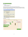
1
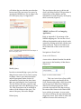
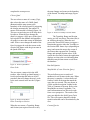
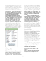
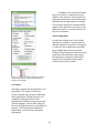
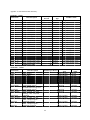
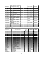
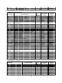
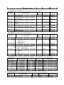
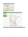
The Natural Resource Decision Support System (NRDSS): Creation of a 9.2 ArcGIS Server
Website and a SQL Server 2005 ArcSDE 9.2 Database for the Minnesota Board of Water
and Soil Resources (BWSR)
Barbara Featherly1,2
1
Department of Resource Analysis, Saint Mary’s University of Minnesota, Winona, MN 55987
2
GeoSpatial Services, Saint Mary’s University of Minnesota, Winona, MN 55987
Keywords: GIS, SSURGO, ArcGIS Server 9.2, ArcSDE 9.2, Microsoft Windows Applications,
Website, SQL Server, ASP.net 2.0, VB.net, Soils Analysis, Soil Suitability
Abstract
In the fall of 2007, GeoSpatial Services (GSS) accepted a contract from the Minnesota Board of
Water and Soil Resources (BWSR) to develop a 9.2 ArcGIS Server application. This application
was to be a web mapping site that would support Soils Survey Geographic Database (SSURGO)
soils data interaction and allow for querying of a subset of the SSURGO dataset for the State of
Minnesota. In order to make management of the site possible, a number of applications and
scripts were created. This paper describes the functionalities and tools designed and built in the
project.
Introduction
The purpose of this research project was to
create an application to aid in the
distribution of soil information to users
across Minnesota using ESRI’s ArcServer
9.2 .NET SDK. This project was labeled the
Natural Resource Decision Support System
(NRDSS) and was developed in conjunction
with needs identified by the Minnesota
Board of Water and Soil Resources
(BWSR). In the past, there were earlier
versions of this application in ArcIMS 9.1
that had been approved by Minnesota Board
of Water and Soil Resources. The ArcGIS
Server version of this project application
was to recreate the functionality of the
former site.
As such, this paper focuses on the
development functionality per infrastructure
requirements. The application had four
infrastructure requirements. The first
requirement involved saving database
information using SQL Server 2005 with the
exception of soils shapefiles that were
packaged with the Soils Survey Geographic
Database (SSURGO). These files were
packaged separately and saved in a
predefined location on the hard drive. The
second requirement stated the application
needed to work in Internet Explorer Browser
6.0 or higher. The third requirement stated
the system and network administrators
would need to have access to the web server
and the database server boxes. The final
requirement was Microsoft Windows
Operating Systems (OS) must be used to
manage the basic web application tools and
startup functions. This included adding the
SSURGO shapefile to the map.
There were several components and
applications required in order to make the
final application manageable and efficient.
The ArcGIS Server web mapping
application was the main website. This
allows users of the internet to view, query,
download, and print maps of soils
information by predefined districts as well
Featherly, Barbara. 2010. The Natural Resource Decision Support System (NRDSS): Creation of a 9.2 ArcGIS
Server Website and a SQL Server 2005 ArcSDE 9.2 Database for the Minnesota Board of Water and Soil Resources
(BWSR). Volume 12, Papers in Resource Analysis. 20 pp. Saint Mary’s University of Minnesota Central Services
Press. Winona, MN. Retrieved (date) from http://www.gis.smumn.edu
as other background information to support
other natural resource management decisionmaking processes. To support the website
and the database, several XP/Server 2003
windows applications were also created:
Clean Files, Clean Up Tables, and Update
Soils. Both clean up tools delete temporary
files and tables created by the website in
response to user requests. The update soils
tool is a service that runs on a local
computer and it allows administrators to
reload SSURGO soils tables for each map
unit.
Since the database uses only select
fields and tables from the entire SSURGO
database, it was necessary to create a
method of updating data where the user
would not require any knowledge of Access
or SQL Server 2005. More about the data
structure will be discussed in the section,
Windows Applications subsection Update
Soils. There are two types of soil queries
that run in the application: selection from a
query tool and predefined queries. In order
to manage the predefined queries, the Query
Administration website was created. The
website allows administrators to create,
modify and delete queries that run against
the soils database.
The SSURGO databases are extensive tables
possessing the ability to contain attributes
for a myriad of soil properties reaching more
than 500 different attributes. The reason for
the number of attributes is because
SSURGO databases are designed to hold
information of all soil structures that may be
present in land within the United States.
Each set of tables is packaged in an Access
database with an associated shapefile of the
study area. NRCS distributes this data to the
public on a website and is aggregated
together by map areas. The map areas
roughly equate to counties in Minnesota
with some larger counties subdivided into
districts.
The SSURGO database contains
many attributes that are relevant to specific
soils types. For example there are places in
the SSURGO database designated for the
definition of soil permafrost characteristics,
these attributes were not included because
there are no soils in Minnesota with
permafrost. In order to limit the database
size and increase application’s performance,
the SSURGO database was simplified to
include only those attributes identified by
BWSR to be relevant to Minnesota soil
structures.
In addition to retaining only a
portion of the attributes, the database was
restructured such that every resulting table
in the database contained a one-to-one
relationship with all the others to allow for a
direct linkage to information in the soil
shapefiles.
Attribute values were retained and
only a few additional fields were generated
to be used for table joining purposes. The
database can be updated automatically using
the soils update tool. In turn, this updates a
single map district published by National
Resources Conservation Service (NRCS),
resulting in an up-to-date soils database for
an area. Refer to the section on the soils
update tool for more information. Refer to
Database
Two databases were created using SQL
Server 2005. The first database was
dedicated to the SSURGO database files and
all related tables. The second database was
dedicated to all other data using SDE 9.2
spatial or tabular data including temporary
tables. The data were split into two groups:
SSURGO data and other data. The following
sections explain the distribution and source
of all data utilized in the main website and
the administration website.
SSURGO data
2
Appendix A for a breakdown of the
attributes from the SSURGO database. Refer
to Appendix B for a complete breakdown of
the data restructuring. The application that
restructures the data assumes that each map
unit has a maximum of six components and
six horizons per component. When a
database had more than six of either a
component or a horizon than the tool retains
the six with the highest percentage of the
total parent unit.
main site also includes a link to the Limick
Aerial Photography service. This link
connects the website to a web media service
controlled by a third party. This service is
provided free of charge and requires that the
main website have access to the internet
outside the network although it can be
configured to run through a proxy server.
Windows Applications
These applications are used for maintenance
purposes. The files are saved on the local
disk. Both cleaning applications are
executable files that are run by the Task
management options of a Windows OS and
were scheduled to run once every hour. The
Update Soils application is a windows
service that actively watches a folder on a
local drive. Whenever the contents change
(file is copied to folder), the system triggers
for the executable to run.
Other Data
There are several other tables contained in
the soils database. One table is an imported
metadata table created by NRCS and
distributed with the SSURGO databases.
This table is used to inform users about the
various fields while they are either creating
a query in the main website or creating a
predefined query in the Canned Query
Administration website. Another table holds
the user information for the Canned Query
Administration website. For each predefined
query created, a SQL Server procedure is
produced in the database and can then be run
by users of the main website.
Another table in the soil database
retains information about the predefined
queries used to populate tools in the main
site and makes the procedures more easily
accessible. In a folder on the server that runs
the website, all of the shapefiles are saved to
a local disk. The final tables contain column
information for fields not defined by
SSURGO and another table for information
describing the SSURGO shapefiles. This
includes a listing of the soil district and
availability status. Not all map areas were
available when this application was created.
The second database was Spatially
Enabled using ESRI ArcSDE 9.2 SP5 and
contains all of the vector data needed by the
site. This includes a 30 meter digital
elevation model for the entire state. The
Clean Files
This executable was made using Visual
Studio 2005 windows form template using
VB as the language and the .net framework.
The ArcServer output folder is defined by
the administrator of ArcGIS Server and can
be found on the web server. This location is
used by all the tools within the application to
create temporary objects and map images.
Every time the executable is run, the
application checks the ArcServer output
folder and looks for all files with the
following extensions: csv, png, tiff, jpg, pdf
and bmp, that are older than a half hour and
deletes them. These are temporary files
created by various tools that run on the
website. When it is finished searching, the
files in the main directory and the
table_export sub directory, the application
stops running.
Clean Tables
3
This executable was made using Visual
Studio 2005 windows form template using
VB as the language and the .net framework.
Every time the executable is run, this
application creates a connection to the
spatially enabled database described in the
Other Data section above. It then searches
the database for all tables starting with
Query_ or Temp_ and tests their created
date. All tables older than a half hour are
deleted from the database. When searching
is finished, the application closes its
connection to the database and stops
running.
directory for more access databases and
follows the same protocol for each database.
If an error occurs during the processing of a
database, the database is not deleted but
moved to the errors folder along with a log
file with the same name as the database file
and describing the error that is preventing
importation. When all of the access
databases found in the directory are
processed, the executable file stops running
and the service starts monitoring the
directory. Whenever the service is stopped,
the monitoring of the directory stops and the
application is no longer triggered.
Update Soils
Website Applications
This executable was made using Visual
Studio 2005 windows service template using
VB as the language and the .net framework.
The service can be installed on any windows
computer in the same network as the
database server. The service is installed on a
computer. Whenever it is running, it
monitors the “C:\update_soils\” directory of
the computer. Whenever a file is copied to
the directory, the service runs an executable
that verifies that the file is an Access
database and that it is finished loading.
In order to extract the map unit from
the Access database, the application
establishes a connection with the SQL
Server Soils database and begins extracting
the needed tables for the database. To save
room, the application only creates tables that
are required to copy the data. For example,
if none of the map units in the access
database have more than 3 components, then
tables for the other three components (4-6)
and horizons (19-36) are not created. When
all the rows for the needed fields are copied
from the Access database, the application
closes its connection with the SQL server
database and deletes the access database
from the directory.
The application searches the
There were two websites created for this
application. Both websites were developed
to run in IIS 6.0 using Windows Server
2003. Any errors that occur in the sites are
saved either in a log file on the local drive or
contained within the IIS standard log
depending on the source of the error.
The first website discussed is the
Administration site for the Canned Queries.
This site is a vb.net ASPX web application
that utilizes form authentication and a user
table to secure the application against
unauthorized use. The purpose of the site is
to create, modify or delete TSQL procedures
that are run in the second application.
Whatever changes or queries are created, the
mapping website responds to these changes
in real-time as long as the user clicks the
finish button for each tool.
The second application is a vb.net
ASPX ArcServer 9.2 mapping web
application called NRDSS. This is the main
site developed. The tools in the application
can be split into these categories: Navigation
or Zoom tools, Soils Queries, and the Soil
export tools.
Administration of Canned Queries
4
First, the user must login to the application
(Figure 1). Once the user has logged in, they
must choose the tool desired for use. Using
frames the website shows a menu that
remains on the left hand side of the client’s
screen (Figure 2). The right hand side of the
screen changes depending on the tool
selected by the user.
The Help link opens a PDF version
of the website’s user manual. To logout of
the site and close the browser window, the
user must click the Exit Site link. To open
the main website, the user clicks the Return
to Mapping Site link.
matching link.
Create Query
There are several steps to creating a query.
To see images depicting these steps refer to
Appendix C where the steps are numbered
in order of use. This was created as a step by
step process. The user creates the query and
then enters each restriction one by one,
finally triggering the creation of a SQL
Server procedure.
The first step allows user to give the
query a name and a label. The name can not
be more than 100 characters and can not
have spaces or under scores in it. The label
will be the name that will be visible in all
dropdown menus like the Existing Queries
drop down. Neither the name nor the label
can be the same as those already in existence
(Figure 3).
Figure 1. Administration Website Login Screen.
Figure 3. Create Name, Label and Description.
After clicking the start button more
options appear. There are three drop down
menus for each of the three different kinds
of soil items: Mapunit, Component, and
Horizon. The user chooses a variable and
clicks the add button under the variable
(Figure 4).
When the user wishes to get more
information about the variables in the drop
downs, they choose a variable and click the
Current Variable Information button. A
description of the variable will appear below
the form the user is working on. The first
line shows the name of the variable, a colon
and the variables data type. The second line
holds the unit of measurement that the value
it may hold. The last paragraph describes
what the variable represents. When finished
looking at the description, the user can click
Figure 2. Administration Menu.
The Contact Information link aids
the user in reporting errors and issues
experienced while running the site. When
the user wishes to run the three main
procedure tools in the application (Create,
Modify and Delete Query), they click the
5
the Close Description button and the area
will turn blank (Appendix C).
with the same label. The predefined query
would give those features (mukeys) with a
value less than 0 and more than 200 the
same label.
Table 1. Examples showing Restriction values.
Numeric or
Textual Entries
Wild Card
Entries
Figure 4. Menus for Soil Data.
Domain Entries
Clicking one of the Add buttons
causes the Choose Operation buttons to be
activated. The name of the variable is added
to the variable restrictions list and the add
buttons disappear. These buttons represent
the different types of comparison operations
that can be done. If the variable has a
domain then only the = and Not buttons are
active. The following is a description of the
operations. See Figure 5 for an image of the
menu: = is the variable equal to entry, < is
the variable less than the entry, > is the
variable greater than the entry, Not is the
variable not equal to the entered value, and
Like is used for textual fields and
determines if the entry has the same value as
the variable. The Like operation is the only
field that the wildcard character % can be
used. Refer to Table 1 for examples of all
the different data entry approaches.
Figure 6. Value Label Menu.
If a user wanted to add another
restriction, they would click on the Add
Restrictions Button and follow the same
procedure illustrated previously. Once all
the labels and all of their restrictions are
added, then the user fills out the Query
description field. If the user clicks the Delete
Button, the variable restriction that is
selected in the list is deleted. Variable
restrictions must be deleted at one time
(Figure 7).
When run from the main website, the
procedure will evaluate a feature until it
finds the first label that applies to it. It
prioritizes from the top to the bottom of list.
If a user wishes to change the priority of a
label, they use the arrow keys (Figure 8).
Variables can only be moved a single
location at a time. The steps a user would
follow would be as follows:
1) Select an entry from the variable
restrictions list.
2) Click the up arrow to increase the
labels priority or click the down
arrow to decrease the labels priority.
Once all the restrictions and the
Query Descriptions have been entered, the
user is to click the Finish button. An alert
Figure 5. Variable Operation Menu.
Finally, the user must add a label so
that users of the main website will be able to
differentiate this restriction from others
(Figure 6).
Also note that several restrictions
can have the same label so that once the
query is run, it will evaluate those
restrictions as a single restriction. For
example, there were two restrictions
(brockdepmin > 200) and (brockdepmin < 0)
6
will inform the user when the procedure has
been created. The user tests a new query by
opening the NRDSS site. For an image, refer
to Create Query step 4 of Appendix C.
The user chooses the query to delete and
click’s the Delete Selected. The procedure is
deleted from of the database and the
information saved for this query in the query
table is removed (Figure 9).
Figure 9. Delete Query Menu.
NRDSS (ArcServer 9.2 web mapping
Application)
Refer to Appendix C for an image of the
NRDSS mapping site. The site has a lot of
different functionalities and each tool can be
opened by clicking on the link with the same
name as the tool. Tools sit in windows on
the left hand side of the screen next to the
map.
Figure 7. Example of the Menu for the Final Steps of
the Create Query Tool.
Navigation or Zoom Tools
Zoom to Soil District
A user selects a district from the list and the
map zooms to the boundary of that district
(Figure 10).
Figure 8. Example of the Menu for the Priority.
Modify Query
In order to start modifying a query, the first
thing the user needs to do is choose a query
to change. Once a query has been chosen
and the appropriate button clicked, all
information is loaded into the form about
that query including the list of restrictions.
The user follows the same work flow and
uses the same tools as the Build Query Tool.
The Table Description can be modified in
order to fit the changes to the query. The
name of the query can not be changed.
Figure 10. Zoom to District Menu.
This is an Active Server Page (ASP)
drop down list that is populated from the
Soils_Districts table using a SQL Query that
runs at page load. When a user chooses a
district, a JavaScript triggers the AJAX
procedure that runs the code that zooms to
the extent of the feature in the District SDE
layer with the given name. As soon as the
user selects a district, the map automatically
triggers the zoom. This is done to reduce the
number of mouse clicks necessary to
Delete Query
7
complete the zoom process.
the map changes and zooms to the boundary
of the entered Township and range (Figure
13).
Choose Quad
The user selects a name of a county (Top),
then selects the name of a 2400k Quad
(Bottom) and the map zooms to the
boundary of the selected quad. By triggering
the change automatically, the number of
mouse clicks needed is reduced (Figure 11).
This was created using two ASP drop down
list objects. When the user changes the
district, it triggers a SQL query of the Quad
look up table in the database and populates
all quads in or near that county in alphabetic
order. When a user changes the name of the
Quad, it triggers the code that zooms to the
extent of the feature with the given name in
the Quads SDE layer.
Figure 13. Zoom to Township or Section Menu.
The Township, Range and Section
entries are ASP text boxes. Direction (Dir) is
an ASP drop down list. When the user
presses the Zoom PLSS button, it triggers a
function that queries either the Township or
the Section SDE feature layer (depending on
entry) and zooms the map to the extent of
the feature that represents the Township,
Range and optional Section values. If the
search does not find a feature the application
displays an alert to the user informing them
that their entry did not return a result from
the database.
Figure 11. Zoom to Quad Menu.
Run Soil Queries
Enter Scale
Map Builder (Create Selection Query)
The user enters a map scale in the ASP
textbox. After clicking go (html button), a
JavaScript function that starts an AJAX
procedure that will change the map’s scale
to the scale entered in the text box (Figure
12).
This tool allows users to search soil
attributes for soil features in the map. When
the query is complete, it selects those soil
features visible in the map that match the
query the user created. They are shown in
yellow and the description is added to the
Table of Contents of the map. Refer to the
Map Builder section of Appendix C for
more information on how this tool works
from a user perspective. The results of the
query are added to the Soils Export Tools
list. This will export a shapefile with the
spatial results that can be downloaded by the
user.
Figure 12. Zoom to Scale Menu.
Enter Township or Section
When the user enters a Township, Range
and Section (not required for tool to run),
Canned Queries
8
The Canned Query Tool allows users to run
predefined procedures created by the Query
Administration website. Refer to the Canned
Query section of Appendix C for more
information on how this tool works from a
user perspective. The tool takes the name of
the procedure that the user selects and runs
the TSQL procedure from the database. The
procedure will run against the tables
representing the Soils data that has been
added to the map. The tool can only function
on a single map district at a time. The results
of the query are added to the map using a
predefined coloration ramp (same for all
queries run from the canned query drop
down list). The layers are added to the TOC
and a Query Results box is added to the
export tools Extract Window (Figure 14).
Only one Query Result is visible at a time.
The user can choose to extract the results as
a shapefile that is imported into a zip file.
box and clicks the Extract Features HTML
button. The system then exports a shapefile
of the features visible in the map that is in
the layer. When the process is complete, the
shapefile is added to a zip file and a link to
that file is added to the results window. The
user can download the file and extract it to a
folder. The shapefile can then be used in
ArcMap.
There are two other types of soil
extracts that can be performed: Extract Soils
Tables and Extract Query Results (Figure
15). Extract Soils Tables allow users to
extract all the soil tables in the database
related to the current soil map survey. The
second tool allows for the extraction of
query results. The tool exports a shapefile of
the results in the map and the related table
that holds the results information including
labels. See section Extract Query Results for
more information.
Extract Soils Tables
When the user clicks the Export Soils Data
html button, a JavaScript function
configures the AJAX procedure that starts
the export process. The system exports
every table entry for all the features visible
in the current map of the added soils map
area. Each table is saved as a csv file
delimited by a semicolon. Once all the tables
are created they are zipped into a uniquely
named zip file and a link is added to the
results table.
Once the tables are downloaded, they
can be extracted to a folder and opened
using Excel or any other database system
compatible with delimited files.
Figure 14. Extract Tools Menu.
Extract Query Results (canned or map
builder)
Refer to Appendix C for a more detailed
description of the workings of this tool.
Soils Export Tools
When the user chooses a soil map area to be
added to the map, a check box is added to
the Extract Tool list with the name of the
map area as a label. The user then checks the
9
In addition, time was spent learning
SQL Server 2005 to create the necessary
database tools required. The integration of
other applications and creation of the Query
Builder made the application user friendly.
It also made it possible for internal BWSR
support of the application by someone who
did not know how to create procedures in a
SQL Server database.
Acknowledgements
I would like to thank Lane Urtel for help.
This project would have been much more
difficult without his experience and support.
I would also like to thank the experts that
answer ESRI support forum questions.
Without all the anonymous information and
experiences shared on those many pages,
this application would have taken much
longer to develop and the final product
would not have been as robust.
Figure 15. Extract soils tables and Extract Features
results along with the extract tool and the Query
Results Layer example.
Conclusion
This paper explains the functionalities of an
end product. The creation of the final
product required large amounts of data and
many applications. During the process of
creating the individual pieces of the
application the author developed experience
with the language (vb.net) in the setting of
the web development process, including best
practices. The design required database
functionality to join the data with spatial
information.
10
Appendix A. Soils Database Data Dictionary.
LEGEND - 1 Table
Field Name
Lkey
Areaacres
Areaname
Areasymbol
Areatypename
Cordate
Legendcertstat
Legenddesc
Legendsuituse
Mlraoffice
mouagncyresp
Projectscale
Ssastatus
ssurgoarchived
isComp1_3
isComp1_3
isHoz01_6
isHoz07_12
isHoz13_18
isHoz19_24
isHoz25_30
isHoz31_36
Brief description
Legend Key
Area Acres
Area Name
Area Symbol
Area Type Name
Correlation Date
Legend Certification Status
Legend Description
Geographic Applicability
MLRA Office
MOU Agency Responsible
Project Scale
Survey Status
SSURGO Archived
Saves Yes/No if table exists
Saves Yes/No if table exists
Saves Yes/No if table exists
Saves Yes/No if table exists
Saves Yes/No if table exists
Saves Yes/No if table exists
Saves Yes/No if table exists
Saves Yes/No if table exists
Culumns per table:
Instances per
Record
1
1
1
1
1
1
1
1
1
1
1
1
1
1
1
1
1
1
1
1
1
1
22
General Data
Type
Text (varchar)
Number
Text (varchar)
Text (varchar)
Text (varchar)
Date/Time
Text (varchar)
Text (varchar)
Text (varchar)
Text (varchar)
Text (varchar)
Number
Text (varchar)
Date/Time
Boolean
Boolean
Boolean
Boolean
Boolean
Boolean
Boolean
Boolean
SSURGO Table
Legend
Legend
Legend
Legend
Legend
Legend
Legend
Legend
Legend
Legend
Legend
Legend
Legend
Legend
Created by update service
Created by update service
Created by update service
Created by update service
Created by update service
Created by update service
Created by update service
Created by update service
MAPUNIT – 1 Table
Field Name
Mukey
Lkey
Muacres
Muname
Musym
aws0150wta
aws025wta
Brockdepmin
Drclassdcd
Drclasswettest
Engsldcd
Engsldcp
Brief description
1
1
1
1
1
General Data
Type
Text (varchar)
Text (varchar)
Number
Text (varchar)
Text (varchar)
SSURGO
Table
mapunit
mapunit
mapunit
mapunit
mapunit
1
Decimal
muaggatt
1
1
Decimal
Decimal
muaggatt
muaggatt
1
1
Text (varchar)
Text (varchar)
muaggatt
muaggatt
1
Text (varchar)
muaggatt
1
Text (varchar)
muaggatt
Instances per Record
Map Unit Key
Legend Key
Map Unit Acers
Map Unit Name
Map Unit Symbol
Available Water Storage 0-150
cm Weighted Average
Available Water Storage 0-25
cm Weighted Average
Bedrock Depth - Minimum
Drainage Class - Dominant
Condition
Drainage Class – Wettest
ENG - Sewage Lagoons Dominant Condition
ENG - Sewage Lagoons Dominant Component
11
Engstafdcd
Engstafll
Engstafml
Flodfreqdcd
flodfreqdmax
Hydgrpdcd
Pondfreqprs
slopegraddcp
slopegradwta
wtdepannmin
wtdepaprjunmin
Hydclprs
ENG - Septic Tank Absorption
Fields - Dominant Condition
ENG - Septic Tank Absorption
Fields - Least Limiting
ENG - Septic Tank Absorption
Fields - Most Limiting
Flooding Frequency - Dominant
Condition
Flooding Frequency Maximum Condition
Hydrologic Group - Dominant
Conditions
Ponding Frequency - Presence
Slope Gradient - Dominant
Component
Slope Gradient - Weighted
Average
Water Table Depth - Annual –
Minimum
Water Table Depth - April June – Minimum
Hydric Classification - Presence
Culumns per table:
1
Text (varchar)
muaggatt
1
Text (varchar)
muaggatt
1
Text (varchar)
muaggatt
1
Text (varchar)
muaggatt
1
Text (varchar)
muaggatt
1
1
Text (varchar)
Text (varchar)
muaggatt
muaggatt
1
Integer
muaggatt
1
Integer
muaggatt
1
Text (varchar)
muaggatt
1
1
24
Integer
Text (varchar)
muaggatt
muaggatt
COMPONENTS - 2 Tables
Field Name
Mukey
Cokey
Brief description
Erokind
Rvindicator
Map Unit Key
Component Key
Erosion Indicator Kind - Listed by
Component
RV indicator - Listed by Component
hydriccriterion
Compkind
Compname
comppct_r
Corsteel
Drainagecl
Frostact
Geomdesc
Hydgrp
Hydricon
Hydricrating
Localphase
map_r
Runoff
slope_r
slopelenusle_r
Hydric Criterions - Listed by Component
Component Kind
Component Name
Percent MapUnit
Risk for Steel Corrosion
Drainage Class
Potential for frost action
Geomorphic Description
Hydrological Group
Hydric Condition
Component Hydric Rating
Local Phase
Average amount of precipitation
Run Off Class
Slope Gradient
Slope Length
12
Instances
per
Record
2
6
General Data
Type
SSURGO
Table
Text (varchar)
Text (varchar)
Mapunit
Component
6
Text (varchar)
6
Text (varchar)
6
6
6
6
6
6
6
6
6
6
0
6
6
6
6
6
Text (varchar)
Text (varchar)
Text (varchar)
Integer
Text (varchar)
Text (varchar)
Text (varchar)
Text (varchar)
Text (varchar)
Text (varchar)
Text (varchar)
Text (varchar)
Decimal
Text (varchar)
Integer
Decimal
Coerosionacc
Coerosionacc
Cohydriccrite
ria
Component
Component
Component
Component
Component
Component
Component
Component
Component
Component
Component
Component
Component
Component
Component
Taxclname
Taxonomic Class Name
Culumns per table:
6
58
Text (varchar)
Component
CHORIZON - Split into 6 tables
Field Name
Mukey
Cokey
aashind_r
awc_r
Chkey
claytotal_r
ec_r
cec7_r
frag3to10
fraggt10_r
hzdepb_r
hzdept_r
Hzname
ksat_h
ksat_l
ksat_r
lep_r
ll_r
om_r
ph1to1h2o_r
pi_r
sandtotal_r
silttotal_r
Texdesc
Texture
Unifiedcl
Brief description
Map Unit Key - in every table
Component Key - in every table
AASHTO group index
Available Water Capacity - Representative Value
Horizon Key - matches all lower records to
component key
Total amount of clay present
Electrical conductivity
Cation Exchange Capacity - Representative Value
Rock Fragments 3-10 - Representative Value
Rock Fragments >10 - Representative Value
Horizon Bottom Depth - Representative Value
Horizon Top Depth - Representative Value
Official Designation
Ksat - High Value
Ksat - Low Value
Ksat - Representative Value
Linear Extensibility -High Value
Liquid Limit - Representative Value
Organic Matter - Representative Value
PH Soil Reaction - Representative Value
Plasticity Index - Representative Value
Total amount of sand present
Total amount of silt present
Horizon Texture Descriptions
Horizon Texture Modifier and Class
Concatenation
Horizon Unified Classes
Columns per table:
All soils data stats
Maximum Number of Tables:
Maximum Number of Columns:
Instances
per
Record
6
6
30
30
General Data
Type
SSURGO
Table
Text (varchar)
Text (varchar)
Integer
Decimal
Mapunit
Component
Chorizon
Chorizon
30
30
30
30
30
30
30
30
30
30
30
30
30
30
30
30
30
30
30
30
Text (varchar)
Decimal
Decimal
Decimal
Decimal
Decimal
Integer
Integer
Text (varchar)
Decimal
Decimal
Decimal
Decimal
Decimal
Decimal
Decimal
Decimal
Decimal
Decimal
Text (varchar)
Chorizon
Chorizon
Chorizon
Chorizon
Chorizon
Chorizon
Chorizon
Chorizon
Chorizon
Chorizon
Chorizon
Chorizon
Chorizon
Chorizon
Chorizon
Chorizon
Chorizon
Chorizon
Chorizon
Chtexturegrp
30
30
122
Text (varchar)
Text (varchar)
Chtexturegrp
Chunified
General Data
Type
SSURGO
Table
Text (varchar)
Text (varchar)
Text (varchar)
Text (varchar)
Text (varchar)
Text (varchar)
Integer
Mdstattabcols
Mdstattabcols
Mdstattabcols
Mdstattabcols
Mdstattabcols
Mdstattabcols
Mdstattabcols
10
998
COLUMNINFO - 1 TABLE
Field Name
Tabphyname
Colphyname
Collogname
Collabel
Uom
Coldesc
Colprecision
Brief description
Table Physical Name
Column Physical Name
Cloumn Logical Name
Column Label
Unit of Measurement
Column Description
Column Precision
13
Instances
per
Record
1
1
1
1
1
1
1
Culumns per table:
7
STOREDQUERY - 1 TABLE (Table created by Stored Query Administrator )
Instances
Field Name
Brief description
per
Record
Sqkey
StoredQuery-key
1
Boolean to determine if query is stand alone or
Islinked
part of a model.
1
reference to next query in the model - link to
linkChild
physical
1
reference to last query in the model - link to
linkParent
physical
1
What order the sequence should run (e.g. 3 would
linkOrder
mean that the query should be run third)
1
Stored Query physical Name - link to physical
sqsname
location
1
Culumns per table:
6
General Data
Type
SSURGO
Table
Text(varchar)
N/A
Bit
N/A
Text(varchar)
N/A
Text(varchar)
N/A
Integer
N/A
Text(varchar)
N/A
Soils_Districts (Copied from the soil districts shapefile)
Field Name
OBJECTID
Brief description
Instances
per
Record
1
General Data
Type
SSURGO
Table
SASTATCODE
NAME
Unique Identifier
Code that represents the data's availability
1 = Tabular Only
2 = Tabular and Spatial
0 = Unpublished
District Name Label
STATUS
Holds the download status of the feature
1st digit = STATATCODE
2nd digit = 1(Downloaded) or 0(Not Available)
1
Integer
Shapefile
PI availability
1 = Yes
0 = No
Columns per table:
1
5
Integer
Shapefile
PI
Integer
Shapefile
1
1
Integer
Text(varchar)
Shapefile
Shapefile
Mdstatdomdet (Copied from Dodge SSURGO soils database - could be copied from any of the databases)
Instances per
General Data
Field Name
Brief description
SSURGO Table
Record
Type
Domainname
1 Text(varchar)
Dodge County - mdstatdomdet
Choice
Choice
1 Text(varchar)
Dodge County - mdstatdomdet
choicesequence
Choice Sequence
1 Integer
Dodge County - mdstatdomdet
Choicedesc
Choice Description
1 Text(varchar)
Dodge County - mdstatdomdet
Lists if domain no
Choceobsolete
longer recorded
1 Boolean
Dodge County - mdstatdomdet
Columns per table:
5
STORED_QUERY_LOG (Stand Alone table created to store password/users for Admin site)
Instances
Field Name
Brief description
General Data Type
per Record
IDField
Unique Identifier
1 Integer
14
SSURGO Table
Data Entry
User_Name
User_Pass
Can_Manage
Login Name
Login Password
Field set if user can delete a query
Culumns per table:
1
1
1
4
Text(varchar)
Text(varchar)
Text(varchar)
Data Entry
Data Entry
Data Entry
Appendix B. Soils Database Data Model.
Appendix C. Web Application Images.
Extract Query Results
Tool allows users to export Query Results as a zipped shapefile.
Click this box to retrieve features data.
Warnings: You must have a soils layer added to the map. Even if soils layer not visible it will extract data for soils
features in the map. This action can take a while so be careful before resubmitting request.
Wait until file link is shown in Results section of the Console.
Click on the Get Data link.
Click on save and follow the wizard instructions.
15
In order to view the query result in ArcMap you will need to extract them to a folder first.
The Query Results Table is saved using a ; as the column delimiter. Open the file in Excel and export the table as a
dbf4 document. Open ArcMap and add the Query Results shapefile and the Query Results dbf4 file. Create a spatial
join between the two Mukey (shapefile) and MKEY (table). Export the shapefile from ArcMap and it will include all
the information from both the Table and the shapefile.
Create Query
Full view of steps one through three.
16
The button Current Variable Information returns a description of a variable includes the data type and unit of
measurement.
Map Builder
Allows user to search soils attributes for soils features in the map.
Window opens when
Clicked
Choose Unit Type:
MapUnit
Component
Horizon
Choose variable that you wish to restrict the results by.
Numbers in image shown above
1. Variable's full name
2. Variable Data Type
3. Unit of Measurement
4. Variable Description
Click Next Step to enter value or restriction.
The Variables data type will determine how the variable's
restriction will be entered.
17
Entry Type #1
Entry Type #2
Entry Type #3
1. Variable is Textual
Enter Text
Click Next Step
2. Variable is Numeric
Enter lowest value in From box
Enter highest value in To box
Click Next Step
3. Variable has a Domain
Choose domain value
Click Next Step
If you have more than one domain in the results list the
results returned will contain features with each domain
entered.
Click Next step to add the restrictions to the list.
Click Go Back to choose a different variable.
The restrictions once added have format:
1. Unit Type restirction from
2. Short name if variabe
3. Variable restriction entered
Click Run Query to get results.
Click Clear List to start a new set of Restrictions.
Canned Query
Tool allows users to run a predefined Query on the soils features in the map.
Choose a query from the list
Click Run Query
Example: If you choose Flooding Frequency
18
Map Contents: Shows which colors have what label.
Map: Each feature is colored according to the Label from the
Map Contents that it corresponds to.
If you choose Hydric Report: A new window will open showing
the report for the entire soil survey area currently added to the
map.
You may need to have pop up blocker off to view the document.
Extract Soils Tables
Tool allows users to export a version of the soils information that has been added to the map. The tables are
exported out as CSV and can be imported into most database systems.
Click this box to retrieve soils data for the soils features in the map.
Warnings: You must have a soils layer added to the map. Even if soils layer not visible it will extract data for soils
features in the map. This action can take a while so be careful before resubmitting request.
Wait until file link is shown in Results section of the Console.
Click on the Get Data link
Click on save and follow the wizard instructions.
In order to view the files in excel you will need to extract them to a folder first.
Each file is saved with using a ; as the column delimiter.
19
Main Website
20