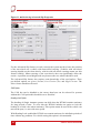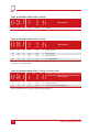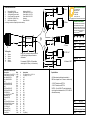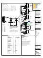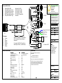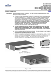
1
RT3000
Inertial
and GPS
Measurement
System
User Manual
Confidently. Accurately.
Legal Notice
Information furnished is believed to be accurate and reliable. However, Oxford
Technical Solutions Limited assumes no responsibility for the consequences of use of
such information nor for any infringement of patents or other rights of third parties
which may result from its use. No license is granted by implication or otherwise under
any patent or patent rights of Oxford Technical Solutions Limited. Specifications
mentioned in this publication are subject to change without notice and do not represent
a commitment on the part of Oxford Technical Solutions Limited. This publication
supersedes and replaces all information previously supplied. Oxford Technical
Solutions Limited products are not authorised for use as critical components in life
support devices or systems without express written approval of Oxford Technical
Solutions Limited.
All brand names are trademarks of their respective holders.
Copyright Notice
© Copyright 2005, Oxford Technical Solutions.
Revision
Document Revision: 050304 (See Revision History for detailed information).
Contact Details
Oxford Technical Solutions Limited
77 Heyford Park
Upper Heyford
Oxfordshire
OX25 5HD
Tel: 01869 238 015
Fax: 01869 238 016
http://www.oxts.co.uk
mailto:[email protected]
2
Oxford Technical Solutions
RT3000 User Manual
Table of Contents
Introduction
6
Easy Operation
7
Self-Correcting
7
RT3000 Family Variants
8
Single Antenna Models
8
Dual Antenna Models
9
Satellite Differential Corrections
9
Scope of Delivery
11
Warranty
13
Specification
14
Environmental Protection
17
Quick Guide to Operation
18
Initialisation Process
20
Real-Time Outputs
20
Warm Up Period
21
System Outputs
Co-ordinate Frame Conventions
LED Definitions
22
22
24
Strapdown Navigator LED States
24
Position Solution (Single Antenna only)
25
GPS Heading Solution (Dual Antenna only)
25
Self-Test LED
26
Power/Comms LED
26
Fitting the Secondary Antenna
27
How the RT3000 uses the Dual-Antenna Measurements
28
Multipath Effects on Dual-Antenna Systems
29
Setting-up the Base Station
Using the RT-Base
Revision: 050304
31
31
3
Using the Novatel Power-Pak
31
Using OmniStar corrections
34
Changing the RT3000’s Configuration
35
Overview
35
Reading the Initial Configuration
35
Orientation of the RT3000 in the vehicle
37
Specifying the Position of the Primary Antenna
38
Specifying the Orientation of the Secondary Antenna
40
Setting the Correct Options
Vehicle Starts Option
Vibration Option
GPS Environment Option
Differential Correction Option
WAAS Option
OmniStar Option
Advanced Slip Option
CAN Option
Heading Lock Option
Garage Mode Option
Initialisation Speed Option
Displace Output Option
Distance Output
Analogue Outputs
Wheel Speed Input
Local Co-ordinates
Get Settings…
41
42
42
42
42
42
42
43
44
44
45
46
46
47
47
49
50
51
Committing the Configuration to the RT3000
52
Saving a copy of the settings locally
53
RT3000 Post-Process Wizard
55
Digital Inputs and Outputs
56
1PPS Output
56
Event Input
57
Wheel-Speed Input
57
Wheel-Speed Output
57
Ethernet Configuration
58
Connection Details
58
4
Oxford Technical Solutions
RT3000 User Manual
Laboratory Testing
60
Accelerometer Test Procedure
60
Gyro Test Procedure
61
Testing the Internal GPS and other Circuitry
62
Deriving further Measurements
63
Computing a Velocity at a remote point
64
Computing the Slip Angle
65
Computing Forward and Lateral Velocities
66
Computing the Forward, Lateral and Down Accelerations
66
Using a Flat Metric Grid
67
Computing Performance Metrics
67
Operating Principles
69
Internal Components
69
Strapdown Navigator
70
Kalman Filter
72
NCOM Packet Format
73
Status Information
77
CAN Messages and Signals
87
Termination Resistor
87
CAN-DB File
87
CAN Bus Messages
87
Table Heading Definitions
88
Signals
89
Revision History
95
Drawing List
96
Revision: 050304
5
Introduction
The RT3000 family of Inertial and GPS Navigation Systems from Oxford Technical
Solutions are instruments for making precision measurements of motion in real-time.
To obtain high precision measurements, the RT3000 uses mathematical algorithms
developed for use in fighter aircraft navigation systems. An inertial sensor block with
three accelerometers and three gyros (angular rate sensors) is used to compute all the
outputs. A WGS-84 modelled Strapdown Navigator Algorithm compensates for earth
curvature, rotation and Coriolis accelerations while measurements from high-grade
kinematic GPS receivers update the position and velocity navigated by the inertial
sensors.
This innovative approach gives the RT3000 several distinct advantages over systems
that use GPS alone:
•
The RT3000 has a high, 100Hz update rate and a wide bandwidth.
•
The outputs are available with very low, 3.9ms latency.
•
All outputs remain available continuously during GPS blackouts when, for
example, the vehicle drives under a bridge.
•
The RT3000 recognises jumps in the GPS position and ignores them.
•
The position and velocity measurements that the GPS makes are smoothed to
reduce the high-frequency noise.
•
The RT3000 makes many measurements that GPS cannot make, for example
acceleration, angular rate, heading, pitch, roll, etc.
•
The RT3000 takes inputs from Wheel-Speed in order to improve the drift rate when
no GPS is available.
The standard RT3000 system processes the data in real-time. The real-time results are
output via an RS232 serial port, over 10/100 Base-T Ethernet using a UDP broadcast
and, optionally, on CAN bus. Outputs are time-stamped and refer to GPS time; a 1PPS
timing sync can be used to give very accurate timing synchronisation between systems.
The inertial measurements are synchronised to the GPS clock.
Internal data logging enables the data to be reprocessed post-mission. Data can be
collected in the unit, downloaded using “ftp”, processed on the PC and viewed using
customer’s software.
6
Oxford Technical Solutions
RT3000 User Manual
Easy Operation
Installation and operation of the RT3000 could not be simpler. There is minimal
configuration required to use the system. The configuration can be saved to the RT3000
so it can operate autonomously without user intervention. A lot of work has been put
into the initialisation of the inertial algorithms so that the RT3000 can reliably start to
navigate in the vast majority of situations.
The single unit contains the inertial sensors, GPS receiver, data storage and CPU. One
or two antennas need to be mounted outside the vehicle where they have a clear view of
the sky. 9 to 18Vd.c. power can be obtained from most vehicles’ power supplies. A
laptop computer allows real-time viewing of the results.
Self-Correcting
Unlike conventional Inertial Navigation Systems, the RT3000 uses GPS to correct all
its measurements. GPS makes measurements of position, velocity and (for dual-antenna
systems) heading. But, using these measurements, the RT3000 is able to keep other
quantities, such as roll and pitch, accurate. There is no drift from the RT3000 in any of
the measurements while GPS is present.
Revision: 050304
7
RT3000 Family Variants
The RT3000 product family includes several different products based on the same
technology. Each product has been selected to serve a different accuracy requirement or
operating condition. The family is split between single antenna systems and dualantenna systems.
The advanced algorithm in the RT3000 software means that most road vehicle
customers are able to use a single antenna system. The Heading Lock and Advanced
Slip features mean that the RT3000 can maintain accurate heading while stationary and
while driving with low vehicle dynamics.
Applications on aircraft or at sea may require a dual-antenna system to maintain high
accuracy heading.
Single Antenna Models
The single antenna models can be used in the vast majority of situations. See the dualantenna section for details of where the dual-antenna systems will provide an
advantage.
The single antenna models are as follows:
•
RT3200 – Differential GPS with positioning accuracy to 1.0m CEP using a suitable
differential source, or 3.0m CEP with no differential corrections.
•
RT3100 – Differential GPS with positioning accuracy to 0.4m CEP using a suitable
differential source, or 1.8m CEP with no differential corrections.
•
RT3020 – L1 Kinematic GPS with positioning accuracy to 20cm RMS.
•
RT3002 – L1/L2 Kinematic GPS with positioning accuracy to 2cm RMS.
•
RT3080 – SBAS-L2 with positioning accuracy to 80cm CEP.
•
RT3050 – OmniStar VBS Enabled with positioning accuracy to 50cm CEP.
•
RT3040 – OmniStar HP Enabled with positioning accuracy to 10cm CEP.
(See section later on for more information on SBAS and OmniStar).
The lower specification systems can be upgraded to a higher specification through a
GPS receiver software upgrade and use of the correct base-station. The Single Antenna
models can also be upgraded to dual-antenna (unless the small box option has been
specified, in which case the second GPS card does not fit).
8
Oxford Technical Solutions
RT3000 User Manual
Dual Antenna Models
With a dual antenna RT3000 product the system uses the difference in position between
the two antennas to keep heading accurate.
Dual antenna systems are recommended for road vehicle testing on low-friction
surfaces (e.g. ice), aerial survey and marine use (ships, survey vessels). GPS-only dualantenna systems require open-sky environments to operate because they can take
several minutes to acquire heading lock. Advanced processing in the RT3000 allows
relock to occur after 5s of a sky-obstruction; in this time the RT3000’s heading will not
have significantly decreased. The fast relock time is made possible because the
RT3000’s own heading is used resolve the ambiguities in the GPS measurements.
Resolution of these ambiguities is what normally takes several minutes. The heading
software in the RT3000 enables significantly better performance and coverage
compared to GPS-only solutions.
The dual antenna models are as follows:
•
RT3102 – Differential GPS with position accuracy to 0.4m using a suitable
differential source.
•
RT3042 – OmniStar VBS Enabled with positioning accuracy to 50cm CEP.
•
RT3052 – OmniStar HP Enabled with positioning accuracy to 10cm CEP.
•
RT3022 – L1 Kinematic GPS with position accuracy to 20cm RMS.
•
RT3003 – L1/L2 Kinematic GPS with position accuracy to 2cm RMS.
The lower specification systems can be upgraded to a higher specification through a
GPS receiver software upgrade and use of the correct base-station.
Satellite Differential Corrections
To improve the positioning accuracy of the standard GPS two satellite based
differential correction services are available. These are WAAS (or EGNOS) and
OmniStar.
SBAS services, such as WAAS and EGNOS, are wide area differential corrections
provided for free. They provide an accuracy of about 1.2m CEP. This service is only
available reliably in North America. The European version exists but cannot be used
with any confidence.
OmniStar is a subscription service. The RT3000 systems that have OmniStar capability
include the necessary hardware to receive the OmniStar corrections. In addition to this
it is necessary to pay OmniStar a license fee to activate the corrections. OmniStar
Revision: 050304
9
provides two levels of correction. These are VBS (Virtual Base Station) and HP (High
Performance).
For more information on OmniStar see the OmniStar web site, www.omnistar.com.
10
Oxford Technical Solutions
RT3000 User Manual
Scope of Delivery
Table 1, below, lists all the items that are delivered with each RT3000 model.
RT3020
RT3002
RT3102
RT3022
RT3003
RT3050
RT3040
RT3080
Description
RT3100
Qty
RT3200
Table 1. Summary of the RT3000 System Components
D
D
D
D
D
D
D
D
D
D
D
D
D
D
D
D
D
D
D
D
D
x2
x2
Vehicle Components
1
RT3000 System Unit
1
User Cable1 (14C0038A)
1
Low Cost User Cable
D
1
GPS Antenna AT575-70
D
1
GPS Antenna AT2775-12
1
GPS-600-LB Antenna
1
5m TNC-SMA Cable
1
Null Modem Serial Cable
x2
D
D
D
D
D
x2
D
D
D
D
D
D
D
D
D
D
D
D
D
Accessories
1
CD-ROM with Manual and
Software
D
D
D
D
D
D
D
D
D
D
1
RT3000 User Manual
D
D
D
D
D
D
D
D
D
D
Note 1: Several different user cables are available. A different cable may be chosen by the customer.
Custom cables are also made. See drawings at the end of the manual for cable specifications.
All the 20cm and 2cm products require the correct Differential Corrections in order to
work to their full specification. Differential Corrections can be supplied by an RT-Base
unit, or other suitable Differential Correction source. See the manual on the RT-Base
for details on the Scope of Delivery for the RT-Base.
In addition to the components supplied the user will require a laptop computer or
another logging system.
Revision: 050304
11
Figure 1. Typical RT3000 system in transit case.
Note that the antenna style has changed since this picture was taken.
12
Oxford Technical Solutions
RT3000 User Manual
Warranty
Oxford Technical Solutions Limited warrants the RT3000 products to be free of defects
in materials and workmanship, subject to the conditions ser forth below, for a period of
one year from the Date of Sale.
‘Date of Sale’ shall mean the date of the Oxford Technical Solutions Limited invoice
issued on delivery of the product. The responsibility of Oxford Technical Solutions
Limited in respect of this warranty is limited solely to product replacement or product
repair at an authorised location only. Determination of replacement or repair will be
made by Oxford Technical Solutions Limited personnel or by personnel expressly
authorised by Oxford Technical Solutions Limited for this purpose.
In no event will Oxford Technical Solutions Limited be liable for any indirect,
incidental, special or consequential damages whether through tort, contract or
otherwise. This warranty is expressly in lieu of all other warranties, expressed or
implied, including without limitation the implied warranties of merchantability or
fitness for a particular purpose. The foregoing states the entire liability of Oxford
Technical Solutions Limited with respect to the products herein.
Revision: 050304
13
Specification
The specification of the products is listed in Table 2, Table 3 and Table 4. These
specifications are listed for operation of the system under the following conditions:
•
After a warm-up period of 15 minutes continuous operation.
•
Open sky environment, free from cover by trees, bridges, buildings or other
obstructions. The vehicle must have remained in open sky for at least 5 minutes for
full accuracy.
•
The vehicle must exhibit some motion behaviour. Accelerations of the unit in
different directions are required so that the Kalman filter can estimate the errors in
the sensors. Without this estimation some of the specifications degrade.
•
The distance from the system to the GPS (primary) antenna must be known by the
system to a precision of 5mm or better. The vibration of the system relative to the
vehicle cannot allow this to change by more than 5mm. The system will estimate
this value itself in dynamic conditions.
•
For dual-antenna systems the relative orientation of the two antennas must be
known to the system to 0.05° or better. The system will estimate this value itself
under dynamic conditions.
•
For single antenna systems the heading accuracy is only achieved under dynamic
conditions. Under benign conditions, such as motorway driving, the performance
will degrade. The performance is undefined when stationary for prolonged periods
of time.
Optionally extended measurement ranges covering 30G acceleration and 300°/s angular
rate may be requested. The specification using the extended measurement range sensors
can be marginally worse than those listed here.
14
Oxford Technical Solutions
RT3000 User Manual
Table 2. Performance Specification for the RT3000 Single Antenna Systems
Product
RT3002
RT3020
RT3100
RT3200
Positioning
L1/L2 Kinematic
L1 Kinematic
SPS / DGPS /
SBAS
SPS / DGPS /
SBAS
Position Accuracy
1.5mCEP SPS
1.2m CEP SBAS
2cm 1σ
1.8mCEP SPS
1.2m CEP SBAS
20cm 1σ
1.8mCEP SPS
1.2m CEP SBAS
0.4mCEP DGPS
3.0mCEP SPS
1.4m CEP SBAS
1.0mCEP DGPS
Velocity Accuracy
0.05 km/h RMS
0.08 km/h RMS
0.1 km/h RMS
0.2 km/h RMS
10 mm/s² 1σ
0.01%
0.1% 1σ
100 m/s²
10 mm/s² 1σ
0.01%
0.1% 1σ
100 m/s²
10 mm/s² 1σ
0.01%
0.1% 1σ
100 m/s²
10 mm/s² 1σ
0.01%
0.1% 1σ
100 m/s²
Roll/Pitch
0.03° 1σ
0.04° 1σ
0.05° 1σ
0.2° 1σ
Heading
0.1° 1σ
0.1° 1σ
0.1° 1σ
0.2° 1σ
Angular Rate
– Bias
– Scale Factor
– Range
0.01°/s 1σ
0.1% 1σ
100°/s
0.01°/s 1σ
0.1% 1σ
100°/s
0.01°/s 1σ
0.1% 1σ
100°/s
0.02°/s 1σ
0.2% 1σ
100°/s
Track (at 50km/h)
0.07° RMS
0.1° RMS
0.15° RMS
0.2° RMS
Slip Angle (at 50km/h)
0.15° RMS
0.15° RMS
0.2° RMS
0.3° RMS
0.2%
0.2%
0.2%
0.35%
Acceleration
– Bias
– Linearity
– Scale Factor
– Range
Lateral Velocity
Update Rate
100 Hz
Calculation Latency
3.9 ms
Power
9-18 V d.c. 15W
Dimensions (mm)
234 x 120 x 80
Weight
2.2 kg
Operating Temperature
–10 to 50°C
Vibration
0.1 g²/Hz 5-500 Hz
Shock Survival
100G, 11ms
Internal Storage
500 MB
Twin Antenna
Upgradeable GPS
No
No
No
No
Yes (RT3003)
Yes
Yes
Yes
Note: The single antenna units may be supplied in a smaller box, with a single antenna port. The
dimensions are 243 x 108 x 68mm and the weight is 2.1kg. This box does not allow the single antenna
system to be easily upgraded to dual antenna.
Revision: 050304
15
Table 3. Performance Specification for the RT3000 Differential Systems
Product
RT3040
RT3050
RT3080
OmniStar HP
OmniStar VBS
SBAS-L2
Position Accuracy
10cm CEP1
50cm CEP
1.8m CEP SPS
0.8m CEP SBAS
Velocity Accuracy
0.07 km/h RMS
0.08 km/h RMS
0.1 km/h RMS
10 mm/s² 1σ
0.01%
0.1% 1σ
100 m/s²
10 mm/s² 1σ
0.01%
0.1% 1σ
100 m/s²
10 mm/s² 1σ
0.01%
0.1% 1σ
100 m/s²
0.03° 1σ
0.04° 1σ
0.05° 1σ
0.1° 1σ (dynamic)
0.1° 1σ (dynamic)
0.1° 1σ (dynamic)
Angular Rate
– Bias
– Scale Factor
– Range
0.01°/s 1σ
0.1% 1σ
100°/s
0.01°/s 1σ
0.1% 1σ
100°/s
0.01°/s 1σ
0.1% 1σ
100°/s
Track (at 50km/h)
0.08° RMS
0.1° RMS
0.15° RMS
Slip Angle (at 50 km/h)
0.15° RMS
0.15° RMS
0.2° RMS
0.2%
0.2%
0.2%
Positioning
Acceleration
– Bias
– Linearity
– Scale Factor
– Range
Roll/Pitch
Heading
Lateral Velocity
Update Rate
100 Hz
Calculation Latency
3.9 ms
Power
9-18 V d.c. 20W
Dimensions (mm)
Weight
9-18 V d.c. 20W
9-18 V d.c. 15W
234 x 120 x 80
2.4 kg
Operating Temperature
2.4 kg
2.2 kg
–10 to 50°C
Vibration
0.1 g²/Hz 5-500 Hz
Shock Survival
100G, 11ms
Internal Storage
500 MB
Twin Antenna
No
No
No
Upgradeable GPS
No
Yes
Yes
Note 1: For OmniStar HP continuous sky may be required for a long period of time (30 minutes or more)
before the accuracy achieves 10cm. The OmniStar HP service can achieve this in complete open-sky and
airborne applications.
16
Oxford Technical Solutions
RT3000 User Manual
Table 4. Performance Specification for the RT3000 Dual Antenna Systems
Product
RT3003
RT3022
RT3102
Positioning
L1/L2 Kinematic
L1 Kinematic
SPS / DGPS / SBAS
Position Accuracy
1.5m CEP SPS
1.2m CEP SBAS
2cm 1σ open sky
1.8m CEP SPS
1.2m CEP SBAS
20cm 1σ open sky
1.8m CEP SPS
1.2m CEP SBAS
0.4m CEP DGPS
Velocity Accuracy
0.05 km/h RMS
0.08 km/h RMS
0.1 km/h RMS
10 mm/s² 1σ
0.01%
0.1% 1σ
100 m/s²
10 mm/s² 1σ
0.01%
0.1% 1σ
100 m/s²
10 mm/s² 1σ
0.01%
0.1% 1σ
100 m/s²
Roll/Pitch
0.03° 1σ
0.04° 1σ
0.05° 1σ
Heading
0.1° 1σ
0.1° 1σ
0.1° 1σ
Angular Rate
– Bias
– Scale Factor
– Range
0.01°/s 1σ
0.1% 1σ
100°/s
0.01°/s 1σ
0.1% 1σ
100°/s
0.01°/s 1σ
0.1% 1σ
100°/s
Track (at 50km/h)
0.07° RMS
0.1° RMS
0.15° RMS
Slip Angle (at 50 km/h)
0.15° RMS
0.15° RMS
0.2° RMS
0.2%
0.2%
0.2%
Acceleration
– Bias
– Linearity
– Scale Factor
– Range
Lateral Velocity
Update Rate
100 Hz
Calculation Latency
3.9 ms
Power
9-18 V d.c. 20W
Dimensions (mm)
234 x 120 x 80
Weight
2.4 kg
Operating Temperature
–10 to 50°C
Vibration
0.1 g²/Hz 5-500 Hz
Shock Survival
100G, 11ms
Internal Storage
500 MB
Twin Antenna
Yes
Yes
Yes
Upgradeable GPS
No
Yes
Yes
Environmental Protection
The RT3000 is rated to IP65. To achieve IP65 it is necessary to have connectors fitted
to both TNC Antenna Connectors and to use self-amalgamating tape over the TNC
connectors.
Revision: 050304
17
Quick Guide to Operation
The basic operation of the RT3000 products is simple. The following steps should be
taken to operate the units.
1.
Fit the RT3000 system to the vehicle with the cable connections facing the rear of
the vehicle. The LEDs should be to the left and the antenna connections to the
right for normal, level operation.
2.
Connect the User Cable (14C0038A) to the RT3000.
Figure 2. RT3000 System in vehicle
3.
Connect the GPS Cable to the RT3000. For quick operation of dual antenna
models connect to the primary (top) antenna connection and do not use the
secondary antenna. Refer to the section on the secondary antenna for additional
information on using the secondary antenna.
4.
Connect the GPS Cable to the GPS antenna.
5.
Secure the GPS antenna on the top of the vehicle where it has a clear view of the
sky and is not obstructed at any angle by masts, aerials or other high objects. For
best results before configuration of the RT3000 system try to keep the antenna
roughly above the RT3000 system. (The RT3000 system will be delivered
expecting the antenna to be 1m above the RT3000 unit with no X- or Y-axis
displacement; it will assume that these measurements are accurate to about 1m).
18
Oxford Technical Solutions
RT3000 User Manual
6.
Use the Null Modem Cable to connect J2 of the User Cable (14C0038A) to a
serial port on a laptop computer. Run the program ENGINUITY.EXE (it can be
run directly from the CD).
7.
Apply power to the RT3000. The bottom LED will turn green to show that power
has been applied. Wait for the top LED to flash red – this will happen when the
operating system has booted and will take about 30 seconds. Wait for the top
LED to turn permanently red – this will happen when the GPS receiver has found
sufficient satellites to provide valid time, position and velocity and will take
between 60 seconds and 20 minutes from power-on. (It is very rare for the GPS to
take 20 minutes to find satellites; the typical lock time is less than 90 seconds,
though if the unit has just been shipped from another part of the world then locktime will increase).
8.
Accelerate gently on a forward direction. The system will initialise and start to
output data once the speed of the vehicle exceeds about 5 m/s (10 km/h). The top
LED will turn orange (when real-time data is not yet available) and then turn
green (after 10 seconds when the outputs are real-time and the latency is to
specification).
The RT3000 is now operating. Fully specification will not be achieved within the first
15 minutes of operation. During this time dynamic vehicle manoeuvres will help the
system achieve full specification.
Revision: 050304
19
Initialisation Process
Before the RT3000 can start to output all the navigation measurements it needs to
initialise itself. Before it can initialise itself it needs to have all the measurements listed
in Table 5, below.
Table 5. Quantities required for Initialisation
Quantity
Description
Time
Measured by internal GPS
Position
Measured by internal GPS
Velocity
Measured by internal GPS
Heading
Approximated to Course over Ground when the vehicle moves with large error.
(Some Dual-Antenna systems can initialise when stationary)
Roll, Pitch
Vehicle Level option: Assumed zero with a large error
Otherwise: Estimated over first 40s of motion with large error.
The system will start when it has estimates of all of these quantities. Course over
Ground will be used to as the initial Heading when the system exceeds 5m/s (18kmh,
about 11mph). If the system is mounted level in the vehicle then the Vehicle Level
option will enable the system to start immediately. Otherwise the system requires about
40s to find approximate values for Roll and Pitch.
For the initialisation process to work correctly, the system requires the user to tell it
which way it is mounted in the vehicle, otherwise the Course over Ground will not be
close enough to the Heading.
Real-Time Outputs
During the initialisation process the system runs 1 second behind so that the
information from the GPS can be compared to the information from the inertial sensors.
After initialisation the system has to “catch-up” this one second lag. It takes 10 seconds
to do this, during the first 10 seconds the system cannot output data in real-time, the
delay decays to the specified latency linearly over this 10 second period.
The user can identify that the outputs are not real-time because the Strapdown
Navigator State LED is orange. When the system is running it real-time this LED is
green.
20
Oxford Technical Solutions
RT3000 User Manual
Warm Up Period
During the first 15 minutes of operation the system will not conform to the
specification. During this period the Kalman Filter runs a more relaxed model for the
sensors. By running a more relaxed model the system is able to:
1.
Make better estimates of the errors in the long term (if it does not get these
correct then they become more difficult to correct as time goes on).
2.
Track the errors in the inertial sensor during their warm-up period (when their
errors change more quickly than normal).
During this period it is necessary to drive the vehicle, otherwise the errors will not be
estimated and the specification will not be reached. The NCOM output message (and
the CAN outputs) includes status information that can be used to identify when the
required specification has been met.
Revision: 050304
21
System Outputs
The system can output data on two serial ports and over Ethernet; if the CAN bus
option is selected then the second serial output is replaced by the CAN bus output. The
outputs are available on the standard cables as follows:
Table 6. Output Connector functions
Connector
Function
J2
RS232 Serial Output, normally NCOM
J4
RS232 Serial Output, normally NCOM
Optionally CAN bus output
J6
10T or 100T Ethernet
The standard serial output of the RT3000 is a proprietary binary format, referred to as
NCOM, this is described in detail at the end of the manual. Oxford Technical Solutions
offers C and C++ code that will interpret the packet. This can be used freely in user’s
programs to interpret the output of the RT3000. For those who wish to interpret the
packet directly, the format is provided here.
It is also possible to have a standard NMEA output from the RT3000 to mimic the
output of GPS standard receivers.
Oxford Technical Solutions offers a service to tailor the serial output format to the
customer’s specifications. Contact Oxford Technical Solutions for details of this
service.
Co-ordinate Frame Conventions
The RT3000 uses a co-ordinate frame that is popular with most navigation systems.
Figure 3, below, shows how the axes relate to the RT3000 box.
22
Oxford Technical Solutions
RT3000 User Manual
Figure 3. RT3000 Co-ordinate Frame Definition
Table 7, below, lists the directions that the axes should point for zero heading, pitch
and roll outputs when the default mounting orientation is used.
Table 7. Direction of Axes for zero Heading, Pitch and Roll outputs
Axis
Direction
Vehicle Axis
X
North
Forward
Y
East
Right
Z
Down
Down
If the axes of the RT3000 and the Vehicle Axes are not the same as those listed in
Table 7, above, then they can be aligned by reconfiguring the RT3000 for a different
mounting orientation. See section, Using OmniStar corrections, below.
Revision: 050304
23
LED Definitions
The front panel of the RT3000 has four LEDs. These give an indication of the internal
state of the system. They can also be used for some simple operational checks on the
system. The definitions of the LEDs are given in Table 8, below.
Table 8. LED Descriptions
LED
Position
1
Top
2
TopMiddle
Description
Strapdown Navigator State
Single Antenna: Position Solution
Dual Antenna: GPS Heading Solution
3
BottomMiddle
OEM4 GPS: Self-test
4
Bottom
Power/Comms
Strapdown Navigator LED States
The Strapdown Navigator LED shows the state of the Strapdown Navigator in the
system. Table 9, below, gives the states of this LED.
Table 9. Strapdown Navigator LED States
Colour
Description
Off
The operating system has not yet booted and the program is not yet running. This occurs at
start-up.
Red
Flash
The operating system has booted and the program is running. The GPS receiver has not yet
output a valid time, position and velocity.
Red
The GPS receiver has locked on to satellites and has adjusted its clock to valid time (the
1PPS output will now be valid). The Strapdown Navigator is ready to initialise. If the
vehicle is travelling faster than 5 m/s then the Strapdown Navigator will initialise and the
system will become active. On dual-antenna systems the system will initialise once the
GPS receiver has determined heading, even if the vehicle is stationary or moving slowly.
Yellow
The Strapdown Navigator has initialised and data is being output, but the system is not
real-time yet. It takes 10 seconds for the system to become real-time after start up.
Green
The Strapdown Navigator is running and the system is real-time.
24
Oxford Technical Solutions
RT3000 User Manual
In current versions of the software the Strapdown Navigator will not leave Green and
return to any other state. This may change in future releases.
Position Solution (Single Antenna only)
The Position Solution LED shows what type of GPS solution is currently being used by
the Kalman filter to update the Strapdown Navigator. Table 10, below, gives the states
of this LED.
Table 10. Position Solution LED States
Colour
Off
Description
The GPS receiver does not have a valid position.
Red
Flash
(Start-up only). The GPS receiver is sending data to the main processor. This is an
operational check for the GPS receiver.
Red
The GPS receiver has a standard position solution (SA) or a differential solution (DGPS).
Yellow
The GPS receiver has a kinematic floating position solution (20cm accuracy).
Green
The GPS receiver has a kinematic integer position solution (2cm accuracy).
GPS Heading Solution (Dual Antenna only)
The GPS Heading Solution LED indicates the state of the dual antenna receiver. Table
11, below, defines the states of this LED.
Table 11. States of the GPS Attitude LED
Colour
Off
Red
Flicker
Red
Description
GPS receiver fault. (Valid only after start-up).
GPS receiver is active, but has been unable to determine heading.
Integer uncalibrated heading lock.
Yellow
The receiver has a floating (poor) calibrated heading lock.
Green
The receiver has an integer (good) calibrated heading lock.
Revision: 050304
25
Self-Test LED
The Self-Test LED gives Novatel information about a failed GPS card. During normal
operation this LED will flash Green.
Power/Comms LED
The Power/Comms LED shows the state of the internal 5V power-supply and the state
of the TX line of the J2 connector. Table 12, below, gives the states of this LED.
Table 12. Power/Comms LED States
Colour
Off
Description
There is no power to the system or the system power-supply has failed.
Green
The 5V power supply for the system is active.
Orange
The system is outputting data on connector J2.
26
Oxford Technical Solutions
RT3000 User Manual
Fitting the Secondary Antenna
For best performance of the dual-antenna systems it is necessary to fit the secondary
antenna to the system. The system is very sensitive to incorrect fitting and operation of
the secondary antenna and these instructions should be followed carefully otherwise it
is unlikely that the system will operate correctly.
Before fitting the secondary antenna bear the following information in mind:
1.
In the default configuration the primary antenna should be at the front of the
vehicle’s roof and the secondary antenna should be at the rear.
2.
The antenna separation must be correct to 3mm or better.
3.
It is essential to orientate the antennas the same way. Always have the cable
exiting from each antenna in the same direction. See Figure 4, below.
Figure 4. Dual-Antenna Orientations
4.
For good multipath rejection the antennas must be mounted on a metal surface
using the magnetic mounts provided; no additional gap may be used. Multipath
affects stationary vehicle more than moving vehicles and it can lead to heading
errors of 0.5 degrees RMS if the antennas are mounted poorly on the vehicle.
5.
For both single antenna systems and dual antenna systems it is essential that the
supplied GPS antenna cables are used and not extended, shortened or replaced.
This is even more critical for dual antenna systems and the two antenna cables
must be of the same specification. Do not, for example, use a 5m antenna cable
for one antenna and a 15m-antenna cable for the other. Do not extend the cable,
even using special GPS signal repeaters that are designed to accurately repeat the
GPS signal. Cable length options are available in 5m, 15m and 30m lengths.
6.
Mount both antennas where they have a clear, unobstructed view of the whole
sky from all angles.
7.
It is critical to have the RT3000 mounted securely in the vehicle. If the angle of
the RT3000 can change relative to the vehicle then the dual-antenna system will
not work correctly. This is far more critical for dual-antenna systems than for
single antenna systems. The user should aim to have no more than 0.05 degrees
of mounting angle change throughout the testing. (If the RT3000 is shock
Revision: 050304
27
mounted then the RT3000 mounting will change by more than 0.05 degrees; this
is acceptable, but the hystersis of the mounting may not exceed 0.05 degrees).
When shipped the antenna separation is set to 1000mm exactly. It is possible to change
the antenna separation distance, either for ease of use or to change the performance (a
larger distance will improve performance). Contact Oxford Technical Solutions for
details on how to change the antenna separation.
How the RT3000 uses the Dual-Antenna Measurements
It is often useful to have an understanding of how the RT3000 uses the measurements
from the Dual-Antenna system. This can lead to improvements in the results obtained.
1.
To use the measurements properly the RT3000 needs to know the angle of the
GPS antennas compared to the angle of the RT3000. This cannot be measured
accurately by users without very specialised equipment; the RT3000 needs to
measure this itself as part of the warm-up process.
2.
The RT3000 will lock on to satellites, but it cannot estimate heading so it cannot
start. (In marine systems can start to perform a static search but this is not used in
cars).
3.
The vehicle drives forward, at about 12mph (or Initialization Speed) the RT3000
assumes that the Heading and Track are similar and initializes Heading to Track
angle.
If the RT3000 is mounted in the vehicle with a large heading offset then the
initial value of heading will be incorrect. This can also happen if the RT3000 is
initialised in a turn. This can lead to problems later.
4.
When the combined accuracy of heading plus the Orientation Accuracy figure for
the Secondary Antenna (see configuration software) is sufficiently accurate then
the RT3000 will solve the RTK Integer problem using the Inertial heading. There
is no need for the RT3000 to solve the RTK Integer problem by searching.
If the antennas are offset from the RT3000 by a lot then the RTK Integer solution
that is solved will be incorrect. It is essential to get the RT3000 orientation and
the Secondary Antenna orientation to within 5 degrees.
5.
Once the RTK Integer solution is available, the RT3000 can start to use the DualAntenna solution to improve heading. The level of correction that can be applied
depends on how accurately the angle of the Secondary GPS Antenna is known
compared to the Inertial sensors.
6.
The Kalman filter tries to estimate the angle between the Inertial sensors and the
Secondary GPS Antenna. The default value used in the configuration software (5
degrees) is not accurate enough so that the RT3000 can improve the heading
28
Oxford Technical Solutions
RT3000 User Manual
using this value. If you want the vehicle heading to 0.1 degrees, but you only
know the angle of the two GPS antennas to 5 degrees, then the measurements
from the antenna are not going to be able to improve the heading of the car.
Driving a normal warm-up, with stops, starts and turns, helps the Kalman filter
improve the accuracy of the Secondary GPS Antenna angle. The accuracy of this
angle is available in the Status information.
7.
In the unlikely event that the RTK Integer solution is incorrect at the start then
the Kalman filter can update the Secondary Antenna Orientation incorrectly. If
this happens then things start to go wrong. The Kalman filter becomes more
convinced that it is correct, so it resolves faster, but it always solves incorrectly.
Solving incorrectly makes the situation worse.
To avoid the Kalman filter from getting things wrong it is possible to drive a
calibration run, then use the Get Settings… option of the configuration software.
This will tell the Kalman filter that it has already estimated the angle of the
Secondary Antenna in the past and it will be much less likely to get it wrong or
change it. This step can only be done if the RT3000 is permanently mounted in a
vehicle and the antennas are bolted on. Any movement of either the RT3000 or
the antennas will upset the algorithms.
Multipath Effects on Dual-Antenna Systems
Dual-antenna systems are very susceptible to the errors caused by multipath. This can
be from buildings, trees, roof-bars, etc. Multipath is where the signal from the satellite
has a direct path and one or more reflected paths. Because the reflected paths are not
the same length as the direct path, the GPS receiver cannot track the satellite signal as
accurately.
The dual-antenna system in the RT3000 works by comparing the carrier-phase
measurements at the two antennas. This tells the system the relative distance between
the two antennas and which way they are pointing (the heading). For the heading to be
accurate the GPS receivers must measure the relative position to about 3mm. The level
of accuracy can only be achieved if there is little or no multipath.
In an ideal environment, with no surrounding building, trees, road signs or other
reflective surfaces, the only multipath received is from the vehicle’s roof. The antennas
supplied with the RT3000 are designed to minimise multipath from the vehicle’s roof
when the roof is made of metal. For use on non-metallic roofs a different type of
antenna is required (for example, the GPS-600 supplied with the base-station). This
type of antenna can be supplied as an option.
When stationary the heading from the RT3000 will show some drift, the size of the
drift depends on the multipath in the environment. Table 13, below, lists the drift you
can expect when stationary with a 1m base-line.
Revision: 050304
29
Table 13. Typical Heading Drift for when Stationary in different Environments
Environment
Typical Drift
Complete Open-Sky
0.6 degrees max (0.2 degrees 1σ)
Near Trees, Buildings
1 degrees
Next to Trees, Buildings
2 degrees
Typical figures using a 1m base-line. For accuracy specification of 0.1 degrees RMS a 2m separation is
required.
30
Oxford Technical Solutions
RT3000 User Manual
Setting-up the Base Station
For correct operation of the higher accuracy systems it is necessary to use a basestation GPS receiver. Refer to Table 1, above, to see if the system includes a basestation. All of the systems can be successfully used without a base-station, however, the
specification will only be met if a base-station is used.
The base-station is a separate GPS receiver that monitors the signals from the GPS
satellites. Using its knowledge of position it works out the errors in each satellite’s
signal. It also measures the carrier-phase of the signal for kinematic corrections. The
carrier-phase observations and the satellite signal errors are sent from the base-station
GPS to the RT3000 via a radio modem (not provided).
The position of the base-station GPS antenna can either be determined by the basestation GPS receiver or can be surveyed in by a chartered surveyor. If the base-station
GPS receiver determines its own position, through position averaging, then any error in
the base-station receiver will also result in error at the RT3000. In order to relate the
RT3000 signals to maps, or other items on the world, it is necessary to have a surveyor
measure the position of the GPS antenna and then tell the base-station GPS receiver
what position to use.
For many applications it is not necessary to survey in the base-station antenna since an
absolute world-reference is not required. Instead, a local grid can be used.
Using the RT-Base
The RT-Base system is a self-contained GPS, Radio Modem and Battery all in an IP65rated ‘Peli’ case. For instructions on how to use the RT-Base see the RT-Base User
Guide.
The RT-Base is supplied with a SATEL radio modem. This should be connected to the
Radio connector of the RT3000 User Cable supplied (normally 14C0021A). This cable
supplies power to the Radio Modem as well as sending the differential corrections to
the RT3000.
Using the Novatel Power-Pak
For base-stations supplied as a Novatel Power-Pak (now superseded by the RT-Base)
the following instructions apply.
You are advised to look at the Novatel Millennium GPSCard Command Descriptions
Manual for more details on how the base-station operates. The manual includes a lot of
information on base-stations and covers the topic in more detail than is described here.
Revision: 050304
31
Recently the type of base-station supplied has changed. The new base-station receivers
use an OEM4 GPS card from Novatel, whereas the original ones use an OEM3 card.
Please follow the instructions specific to your card where marked in the text.
To set up a base-station the following steps must be followed.
1.
Place the base-station GPS receiver at a suitable location. The receiver should be
inside in a dry environment and it will require a 12V (9-36V) d.c. power supply.
2.
Place the GPS antenna where it has a clear view of the whole sky. It is very
important for the base-station GPS to have full view of the whole sky; any
satellite it cannot receive cannot be used by the RT3000, even if the RT3000 can
see the satellite. It is also important to place the GPS antenna in a low multipath
environment.
3.
Connect the GPS antenna to the base-station GPS receiver using the GPS antenna
cable provided.
4.
Connect COM1 of the base-station GPS receiver to a laptop computer
5.
Run Novatel’s GPSoln32 (OEM3 model) software or GPSolution4 (OEM4).
(This software is included on the RT3000 Software CD in the OEM3/OEM4
directory. It will need to be installed on the computer.)
6.
Open a connection to the GPS receiver. Any baud rate can be used as the
software will search for the correct baud rate. Open a Command Console window
and an ASCII Logs window. The best baud rate to use for connecting to the basestation is the default, 9600.
7.
If the base-station GPS receiver is determining its own position use the POSAVE
command to average the position and then store it. For example, to average the
position for 0.1 hours (6 minutes) type:
POSAVE 0.1↵
(OEM3 or OEM4 receiver)
If the base-station antenna position is known then use the FIX POSITION
command to enter the exact position of the antenna. For example, to fix the
position of the GPS antenna at 51.3455323 degrees north latitude, 114.289534
degrees west longitude and 1201.123 metres above the geoid reference type:
POS FIX 51.3455323 –114.289534 1201.123↵
(OEM3)
FIX POSITION 51.3455323 –114.289534 1201.123↵ (OEM4)
Refer to the Novatel Millennium GPS Card Commands Description Manual for
more details on these commands.
32
Oxford Technical Solutions
RT3000 User Manual
8.
Once the base-station has fixed its position, this position can be saved to nonvolatile memory and used automatically next time the GPS receiver is turned on.
To do this type:
SAVECONFIG↵
9.
While the base-station is averaging its position connect COM2 of the base-station
GPS to the radio modems. The communications settings of the radio modem will
have to match the communication settings of the GPS receiver, listed below.
Note: If the base-station antenna is moved then it is necessary to re-average the
position or to re-enter the new surveyed co-ordinates. Once the base-station has had its
position fixed the valid position light will be on, even when there are no valid satellites
(i.e. at start-up before it has correctly acquired the satellites and before it is transmitting
valid corrections).
Revision: 050304
33
Using OmniStar corrections
RT3000 products that have OmniStar decoders in them can be used to get corrections
from OmniStar satellites. The RT3000 family members support both OmniStar VBS
(giving 50cm CEP) and OmniStar HP (giving 10cm CEP in extended periods of open
sky).
Before OmniStar corrections can be used it is essential to get a license from OmniStar.
To get a license the following must be done:
1.
The configuration software needs to be used to set the satellite that the RT3000
will use to get corrections. There are only a few satellites available, so this is not
something that needs to be changed often.
2.
Set up the RT3000 outside and turn it on. Make sure that it has a good view of the
open sky. Check that the RT3000 is tracking the OmniStar satellite, this can be
found in the Status information. For an HP license it can take 45 minutes of
continuous tracking to get the full information for HP corrections.
3.
Call OmniStar are ask them to activate the OmniStar receiver. They will need the
serial number of the OmniStar card in the RT3000. This is given on the delivery
note of the RT3000.
4.
After the license has been sent, the RT3000 will operate in VBS mode. If an HP
license has been sent then it may take 45 minutes before HP will start to work; an
almanac transmission is required, and this is only sent slowly. Any break in the
OmniStar transmission will mean that the almanac cannot be received.
After OmniStar is configured and a valid license is obtained, the RT3000 will
automatically use OmniStar whenever it is available. The availability of the OmniStar
signal can be monitored using the Status Information.
34
Oxford Technical Solutions
RT3000 User Manual
Changing the RT3000’s Configuration
The default parameters that the RT3000 is shipped with will work for most
applications. To get the best results from your RT3000 it is necessary to change the
configuration to suit the way you have installed the RT3000 in your vehicle.
The program RT3000Cfg.EXE can be used to do this. This section describes how to
use RT3000Cfg and gives additional explanations on the meanings of some of the
terms used.
It is only possible to change the RT3000’s configuration using Ethernet. It is necessary
to have the Ethernet on your computer configured correctly in order to communicate
with the RT3000 and change the settings.
Overview
In order to give the best possible performance, the RT3000 needs to know the
following things:
•
The orientation that the RT3000 is mounted at in the vehicle
•
The position of the Primary GPS antenna compared to the RT3000
•
The orientation of the Dual-antennas compared to the RT3000
•
Position of the Rear-Wheels (or non-steering wheels) compared to the RT3000
•
Some environment parameters
Many of these parameters the RT3000 can figure out by itself, but this takes time.
Measuring the parameters yourself and configuring the RT3000 shortens the time
before full specification can be met.
If the RT3000 has been running for some time, it will have improved the measurements
that you have made. It is possible to read these improved measurements into
RT3000Cfg, commit them to the RT3000 and then use them next time you start the
system. If you move the RT3000 from one vehicle to another it is essential that you
return to the default configuration rather than using a set of parameters that have been
tuned for a different vehicle.
Reading the Initial Configuration
The first page of RT3000Cfg gives several options for reading the configuration from
different places. Figure 5, below, shows RT3000Cfg just after it is started.
Revision: 050304
35
Figure 5. RT3000Cfg Initial Screen
Default Settings. To use the default settings select this radio button. The following
pages will contain the default settings that the RT3000 was delivered with.
Read from a Folder. It is possible to store a configuration in a folder. The
configuration requires several files so it is tidier to keep it in a folder by itself. To read
the configuration from a folder select this radio button. A group box will appear and the
folder can be selected.
Read from an RD File. The RT3000 writes the configuration it is using to the
internally stored RD file. This option extracts the configuration used at run time.
Read Initial Settings from RT3000. If the RT3000 is connected to the computer
via Ethernet then it is possible to read the initial settings directly from the RT3000. The
initial settings are the settings that the RT3000 starts up with, before it makes any
improvements. Select this radio button and enter the correct IP address of your
RT3000.
36
Oxford Technical Solutions
RT3000 User Manual
Orientation of the RT3000 in the vehicle
The RT3000 can be mounted at any angle in the vehicle. The outputs can be rotated so
that the measurements can be referenced to the vehicle co-ordinate frame. For correct
initialisation it is also necessary to get the heading orientation correct. If the ‘vehicle
level’ option is used then the pitch and roll orientations must also be correct.
The RT3000 gets its initial heading by assuming that the lateral velocity or slip angle is
small. If the definition of the vehicle’s X-axis (forward direction) is incorrect in the
RT3000 then it will not initialise correctly when the vehicle drives forwards.
The orientation of the RT3000 in the vehicle is normally specified using three
consecutive rotations that rotate the RT3000 to the vehicle’s co-ordinate frame. The
order of the rotations is Heading (Z-axis rotation), then Pitch (Y-axis rotation), then
Roll (X-axis rotation). The RT3000 co-ordinate conventions are listed in Figure 3,
above and Table 7, above. Take care to get the order of the rotations correct.
When using the Oxford Technical Solutions RT-Strut the orientation will need to be
changed. The RT-Strut has the Y-axis pointing right and the Z-axis pointing
backwards.
Figure 6, below, shows the orientation screen of RT3000Cfg.
Figure 6. RT3000Cfg Orientation Screen
Revision: 050304
37
To work out the direction that the RT3000 is mounted at look to see which directions
the Y-axis and the Z-axis are pointing. Then enter these directions in to the software.
The greyed out Advanced Settings will change to show the three rotations associated
with orientation chosen.
To make small adjustments use the advanced settings. This allows the user to ‘zero’
any slip angle offsets, pitch offsets or roll offsets.
When using Advanced Slip, the RT3000 can estimate the Slip Angle offset of the
RT3000 compared to the car. Once the RT3000 is initialised and warmed-up select the
Get Settings… button. This will read the RT3000’s estimate of Slip Angle offset
automatically and ensure that a slip angle of zero is measured when driving straight on
a level track.
More information on the Get Settings… option is provided later on in the manual.
Specifying the Position of the Primary Antenna
The RT3000 is able to measure the position of the Primary Antenna itself. However,
this takes time and better results can be achieved sooner if the user measures the
distance accurately. Getting these measurements incorrect is one of the main reasons
for poor results from the RT3000, so it is important to be careful with the
measurements.
The RT3000 is much better at measuring the position of the GPS antenna in 2cm mode
compared with 1.8m mode. In 2cm mode the antenna position can be estimated after a
few circles, whereas in 1.8m mode it can take several hours. When using the RT3000 in
1.8m mode it is recommended to measure the GPS antenna position accurately.
Figure 7, below, shows the Primary Antenna screen.
38
Oxford Technical Solutions
RT3000 User Manual
Figure 7. RT3000Cfg Primary Antenna Screen
It is necessary to tell the RT3000 the distance from the measurement point (shown on
diagram 14A0007x at the end of this manual) to the GPS antenna measurement point.
This should be entered in the vehicle’s co-ordinate frame (note that the software
deliberately uses a left-handed co-ordinate frame here because it is conceptually
easier).
The accuracy of the measurements should also be specified. Care should be taken here
because it is very easy to measure distance to 1cm or better in a straight line. It is much
harder to measure to 1cm through a car roof and it is much harder to measure to 1cm if
the RT3000 is slightly misaligned in the vehicle. Any alignment errors should be
included in the accuracy that you believe you can measure to.
Telling the RT3000 that you have measured the distances to 1mm may lead the
RT3000 to believe its results are better than they really are. You may be impressed by
the accuracy that the RT3000 reports, but in reality it will not be that accurate. It is
better to overestimate the accuracy than to underestimate it.
The RT3000 will try to improve the position of the Primary GPS Antenna. To use the
values that the RT3000 has estimated select the Get Settings… option. More
information on the Get Settings… option is provided later on in the manual.
Revision: 050304
39
Specifying the Orientation of the Secondary Antenna
If your system has two antennas then it is necessary to tell the RT3000 the orientation
of the two-antenna system compared to the vehicle. It is critical to tell the RT3000 the
exact distance between the two antennas (to 5mm or better).
Figure 8. RT3000Cfg Secondary Antenna Screen
It is best to mount the two antennas on the top of the vehicle. Although it is possible to
mount one on the roof and one of the bonnet (hood), in reality the multi-path reflections
from the windscreen will degrade the performance of the system.
If the antennas are mounted at significantly different heights or if the mounting angle is
not directly along a car axis (forward or right) then use the advanced settings.
Getting the angle wrong by more than 3 degrees can lead the RT3000 to lock on to the
wrong heading solution. The performance will degrade or be erratic if this happens.
The RT3000 does not estimate the distance between the two antennas. It is essential to
get this right yourself, otherwise the system will not work correctly and the
performance will be erratic. The measurement needs to be accurate to 5mm, preferably
better than 3mm.
40
Oxford Technical Solutions
RT3000 User Manual
The RT3000 will improve the estimate of the Secondary Antenna settings. To use the
values that the RT3000 has estimated click the Get Settings…button. More information
on the Get Settings… option is provided later on in the manual. Before using this option
for Dual-Antenna systems the following should be considered:
•
If the antennas are mounted magnetically on the roof and someone moves the
antenna then the values estimated by the RT3000 will be incorrect for the new
antenna positions. This will lead to poor Slip Angle performance.
•
If the RT3000 is not mounted very securely in the vehicle and someone knocks it
and changes the mounting angle then the values estimated by the RT3000 will be
incorrect for the new RT3000 mount angle. This will lead to poor Slip Angle
performance.
For these reasons it is recommended to only use the Get Settings… option for DualAntenna systems when the RT3000 is permanently and securely mounted.
Setting the Correct Options
The Options Page includes some important settings for getting the best results from
your RT3000 system. Figure 9, below, shows the Options screen.
Figure 9. RT3000Cfg Options Screen
Revision: 050304
41
Vehicle Starts Option
If you know that the vehicle will be level when starting (to within about 5 degrees) then
the Level option can be used. This saves about 40 seconds during the initialisation
process since the RT3000 does not have to take the time to compute an initial roll and
an initial pitch. In high vibration environments the Not Level option may not work and
so the RT3000 can only start if the vehicle is level and the Level option has been
specified.
Vibration Option
The Normal vibration level is adequate for most circumstances. The RT3000 is very
tolerant of vibration and has been used successfully in environments with more than 2g
RMS using the Normal setting. If the velocity innovations are very high and many GPS
packets are being dropped then this setting can be changed.
GPS Environment Option
If the system is used predominantly in open-sky then the open-sky setting should be
used. In environments with a lot of GPS multi-path the other two settings can be used.
This will allow less accurate GPS measurements to update the system.
Differential Correction Option
The RT3000 can be configured to use several different Differential correction message
types on connector J3. The RT-Base transmits RTCA messages. RTCM (RTCM-104)
or CMR (Trimble) can also be selected or the port can be disabled. The Advanced
option should not be used except in specialised applications. The corrections are always
received at 9600 baud.
WAAS Option
For WAAS enabled systems the GPS receiver can be set up to receive corrections in
North America or Europe. Because WAAS (North America) and EGNOS (Europe) are
in test mode they can sometimes be unreliable; the corrections can be disabled by
selecting None. For systems that do not have WAAS capability this setting has no
effect and is ignored.
OmniStar Option
For OmniStar Enabled Systems the correct satellite should be selected for the region
where you are operating. The correct satellite must be selected before OmniStar can
send a new license. For systems that do not have OmniStar capability this setting has
no effect and is ignored.
42
Oxford Technical Solutions
RT3000 User Manual
Figure 10. RT3000Cfg OmniStar Properties
Several satellites have been pre-programmed into the software. In the future more
satellites may exist, or their properties may change. In this case it is necessary to use
the Advanced Settings to set the Satellite’s Frequency and Baud Rate.
Advanced Slip Option
The Advanced Slip feature uses characteristics of land vehicle motion to improve
heading and slip angle. This feature must be disabled for airborne and marine systems
where the lateral velocity can be significant. The Advanced Slip feature applies heading
correction when the land vehicle is not slipping; when the car is slipping the lateral
acceleration is usually large enough so that the normal heading corrections provide
excellent results.
Revision: 050304
43
Figure 11. RT3000Cfg Advanced Slip Properties
For the Advanced Slip feature to work correctly the system needs to know the position
of the rear-wheels on a vehicle with front-wheel steering. (Vehicles with rear-wheel
steering should use the front wheels; vehicles with all wheels steering cannot use this
feature reliably). Minor steering of the rear-wheels does not significantly affect the
results. A position at road height, mid-way between the rear wheels should be used.
The Advanced Slip feature also requires some knowledge of the road surface. Three
pre-defined options are given, Normal, Low Friction (Ice) and High Friction. The
Other feature should not be used.
CAN Option
The CAN bus can be disabled or the correct baud rate can be selected. In systems
without the CAN option this should be set to Disabled.
Heading Lock Option
The heading of Single Antenna systems can drift when the RT3000 remains stationary
for long periods of time. To solve this the RT3000 includes an option to lock the
heading to a fixed value when stationary. This option cannot be used if the vehicle can
turn on the spot (i.e. turn with zero speed).
With Heading Lock enabled the RT3000 can remain stationary for indefinite periods of
time without any problems. For vehicle testing this option is recommended.
44
Oxford Technical Solutions
RT3000 User Manual
Garage Mode Option
The Garage Mode option can be used to stabilise the RT3000 outputs when GPS is not
available. For example, GPS can be blocked when the vehicle returns to the garage to
have some modifications. Without Garage Mode the RT3000 may drift too far and may
not be able to recover.
When Garage Mode is active, the RT3000 applies a gentle velocity update and assumes
that the vehicle is stationary. This keeps the roll, pitch and velocity within acceptable
limits while the RT3000 has no GPS. With Heading Lock also enabled, the RT3000
can also keep the heading accurate while stationary.
Figure 12. RT3000Cfg Garage Mode Properties
The default settings are usually sufficient for Garage Mode to operate successfully.
However, if you are using the RT3000 in tunnels or in other environments where GPS
is not available for long periods of time then it may be necessary to increase the Initial
Delay setting.
The other two settings are mainly for research and should not be changed.
Revision: 050304
45
Initialisation Speed Option
The default starting speed for the RT3000 is 5m/s. However, some slow vehicles
cannot achieve this speed. For these vehicles adjust the Initialisation Speed to a
different value.
If a speed less than 5m/s is selected then care should be taken to make sure that the
RT3000 is travelling straight when it initialises.
Displace Output Option
The RT3000 can displace or move its outputs to another location in the vehicle. This
simulates the RT3000 being mounted at the new location, rather than at its actual
location.
To enable Output Displacement select this option and enter the offsets to the new
location in the vehicle.
Figure 13. RT3000Cfg Output Displacement Properties
46
Oxford Technical Solutions
RT3000 User Manual
Distance Output
It is possible to have the RT3000 configured to simulate the output of a wheel encoder.
This will be in the form of TTL pulses, each pulse representing a distance travelled.
Using the Distance Output option the scaling of this output can be configured, in pulses
per metre travelled.
Analogue Outputs
The configuration of the RT-ANA is done using the RT3000 Configuration Software.
There are 16 channels in the RT-ANA, numbered from 0 to 15. The channel selection,
range and scaling for all 16 channels can be configured. Double-click on a specific
channel to change the settings.
Note: The CAN bus must be configured correctly for the Analogue Outputs to work
correctly.
Figure 14. RT3000Cfg Analogue Outputs Configuration
Revision: 050304
47
Angular Acceleration Filter (Ang Acc Filter)
Due to vibration angular acceleration is very noisy. When it is used it is normally
filtered. The RT3000 can filter the Angular Acceleration outputs using a second order
low-pass filter. The characteristics of the filter can be set and viewed in the Angular
Acceleration Filter Option Page.
Designing the right filter is always a compromise between the noise reduction and the
filter delay. To help choose the filter you require, the software will compute the
maximum delay over the 0 to 5Hz interval and the Noise Reduction Factor over the full
bandwidth. The Noise Reduction Factor is the ratio of the filtered noise compared to
the unfiltered noise assuming that the vibration is white (i.e. same amplitude across the
frequency spectrum). A graph showing the delay with respect to frequency can also be
plotted. The delay is the additional delay of the filter and not the total delay of the
angular acceleration output. The RT3000 has other delays, like calculation delay, too.
Figure 15. RT3000Cfg Angular Accelerations Filter Configuration
48
Oxford Technical Solutions
RT3000 User Manual
Wheel Speed Input
The RT3000 can be factory configured to include a Wheel Speed Input. This reduces
the drift in the outputs when GPS is not available.
To use the Wheel Speed Input the RT3000 needs to be configured to know the number
of pulses per metre that the wheel generates, the accuracy expected from the wheel
gripping on the road surface and the vector from the RT3000 to the wheel centre. The
RT3000 will improve the accuracy of the Wheel Speed Scaling when GPS is available.
The RT3000 will not work properly if the encoder is measuring two wheels (i.e. after a
differential) since the actual position of the wheel is required for accurate navigation. If
a post-differential encoder must be used then the accuracy cannot be guaranteed.
The RT3000 will improve the estimate of the Wheel Speed Scaling. To use the value
that the RT3000 has estimated select Get Settings… on the Get Setting tab. If this
option is used then the RT3000 should be allowed to recalibrate the scaling value
occasionally to account for tyre wear. To do this return the to within value to 1% again
and perform a calibration drive.
Figure 16. RT3000Cfg Wheel Speed Input Configuration
Revision: 050304
49
Local Co-ordinates
The RT3000 can output the displacement from an origin in a local co-ordinate grid. To
use this option a “zero” location or origin must be chosen; the latitude, longitude and
altitude for the origin must be entered in to the RT3000. If an RT-Base is available then
these will be shown on the LCD display. A rotation can also be specified to rotate the
XY directions.
Figure 17. RT3000Cfg Local Co-ordinate Configuration
50
Oxford Technical Solutions
RT3000 User Manual
Get Settings…
The Get Settings… option, which appears on several pages of the RT3000
Configuration Software, should be used to read improvements that the RT3000 has
made to the configuration parameters. This can be useful for making the measurements
more consistent and for reducing the warm-up time.
Figure 18. Process of improving RT3000 Settings
The settings can be read from three sources:
•
from an NCOM file. If an NCOM file has been saved to disk, or processed using
the post-process utility then this file can be read and the settings extracted from it.
Use this setting if you have an NCOM file.
•
from an RT3000 connected to the serial port. This will get the information that the
RT3000 is using at the moment and apply it next time the RT3000 starts. Use this
setting if the RT3000 is running, has initialised and has warmed up.
•
from an RT3000 connected to the Ethernet port. This will get the information that
the RT3000 is using at the moment and apply it next time the RT3000 starts. Use
this setting if the RT3000 is running, has initialised and has warmed up.
Once the source has been selected the software will find which settings can be obtained
from the source. Settings that cannot be obtained will be shown in grey; this may be
because the RT3000 was not calculating these values at present.
You may update several parameters at once using the Get Settings… option. Select
which settings you want to be updated and uncheck the ones that you do not want to
update. When you press Finish these settings will be transferred to the wizard.
Revision: 050304
51
Figure 19. RT3000Cfg Get Settings Pages
Committing the Configuration to the RT3000
The changes to the RT3000 settings must be performed using Ethernet. It is necessary
to configure your computer’s Ethernet settings so it is on the same network as the
RT3000. If necessary, ask you system administrator to help.
Figure 20, below, shows the Commit screen.
52
Oxford Technical Solutions
RT3000 User Manual
Figure 20. RT3000Cfg Commit Screen
Enter the IP address of the RT3000 that you want to configure. The IP address is
usually 195.0.0.x where x is the serial number of the RT3000.
The changes to the configuration do not take effect until after the RT3000 is reset (or
next power on). To reset the RT3000 after downloading check the Reset RT3000 after
downloading files check box.
Press Commit to save the configuration on the RT3000.
Saving a copy of the settings locally
Before finishing it is possible to save a copy of the settings in a folder on your
computer. This can then be reloaded next time. The Finish screen also lets you know if
the settings have been committed successfully to the RT3000 or not. Figure 21, below,
shows the Finish screen.
Revision: 050304
53
Figure 21. RT3000Cfg Finish Screen
To save a copy of the settings in a local folder check the Preserve these settings in
folder check box and enter the folder name.
54
Oxford Technical Solutions
RT3000 User Manual
RT3000 Post-Process Wizard
The data stored on the RT3000 is in a raw, unprocessed format; these files have an
“rd” extension. The advantage of this is that it can be reprocessed with different
configuration settings. For example, if the configuration was configured incorrectly
when running in real-time then the configuration can be changed and the data can be
reprocessed post-mission.
The RT3000 Post-Process Wizard can be used to reprocess the data. The RT3000 PostProcess Wizard also gives the user the ability to change the NCOM binary output
format to text. Figure 22, below, shows the first step of the Wizard.
Figure 22. RT3000 Post-Process Wizard – Step 1
There are three options to the Wizard. The Wizard can load an “rd” file from the
RT3000 and save it on the PC before processing the file. If the file has already been
loaded on to the PC then the Wizard can process the file directly. If the file has already
been processed (and is now in NCOM format) then it can change the file to text.
The RT3000 Post-Process Wizard if fairly self-explanatory. If additional help is
required then please contact Oxford Technical Solutions.
Revision: 050304
55
Digital Inputs and Outputs
There are several different digital inputs and outputs available from the RT3000. Older
systems, shipped with RT3000 User cables before 14C0038A only have one digital
connection and this is normally configured as 1PPS.
The RT3000 User Cable 14C0038A gives the user several digital inputs and outputs.
The normal configuration for these is listed in Table 14, below.
Table 14. 14C0038A RT3000 User Cable Digital Connections
Pin
Direction
Description
Digital 1
Output
1PPS from GPS receiver
Digital 2
Input
Event Input
Digital 3
Input
Wheel-Speed Input (from Tacho on a single wheel)
Digital 4
Output
Wheel-Speed Output simulation
Digital 5
Reserved
1PPS Output
The 1PPS output is a pulse from the GPS receiver. The falling edge of the pulse is the
exact transition from one second to the next in GPS time. The pulse is low for 1ms then
high for 999ms and repeats every second.
Figure 23. 1PPS Waveform
The output is a Low-Voltage CMOS output, with 0.8V or less representing a low and
2.4V or more representing a high. No more than 10mA should be drawn from this
output. There is no protection on this output (protection circuitry would disturb the
accuracy of the timing).
56
Oxford Technical Solutions
RT3000 User Manual
Event Input
The Event Input can be used to time events, like the shutter of a camera or a brake
switch. No more than one event per second should be used. The Event Input has a pullup resistor so it can be used with a switch or as a CMOS input. A Low-Voltage requires
less than 0.8V on the input and a high voltage requires more than 2.4V on the input.
There is no protection on this input (protection circuitry would disturb the accuracy of
the timing). Keep the input in the range of 0V to 5V.
Wheel-Speed Input
The Wheel-Speed Input accepts TTL pulses from an encoder on a single wheel. An
encoder from a gearbox should not be used, and simulated TTL pulses (e.g. from the
CAN bus) should not be used. The timing of the Wheel-Speed Input pulses is critical
and nothing should cause any delay in the Wheel-Speed Input pulses.
The Wheel-Speed Input requires less than 0.8V for a low pulse and more than 2.4V for
a high pulse. Limited protection is provided on this port, however the input voltage
should not exceed 12V.
Wheel-Speed Output
The Wheel-Speed Output generates pulses in the same way as a wheel encoder would.
The configuration software can change the number of pulses per metre of travel. The
output has 0.8V or less for a low and 2.4V or more for a high. There is no protection on
this output, no more than 10mA should be used on this output.
Revision: 050304
57
Ethernet Configuration
To obtain maximum use of the RT3000 it is necessary to use the Ethernet connection.
The operating system at the heart of the RT3000 product allows connection to the unit
via FTP. The use of FTP allows the user to manage the data logged to the unit; files can
be uploaded for reprocessing and deleted to make space for future files. Configuration
files for alternative configurations require FTP to put the configuration files on to the
RT3000.
The RT3000 outputs its data over Ethernet using a UDP broadcast. The use of a UDP
broadcast allows everyone on the network to receive the data sent by the RT3000.
It is advisable to use the RT3000 on its own private network. This will help avoid loss
of data through collisions on the network. Due to processing restrictions in the unit and
collisions on the network it is advisable not to use the FTP services while the unit is
being used to process data. The FTP server has a very low priority and will be slow
while the RT3000 is running (i.e. while the top LED is green).
The settings of the RT3000’s Ethernet adapter are given in Table 15, below.
Table 15. RT3000 Ethernet Settings
Setting
Value
IP Address
The IP Setting will be shown on the delivery note accompanying the RT3000.
Subnet Mask
255.255.255.0
FTP User
“user”
FTP User Password
“user”
For details on the output packet format of the UDP broadcast, contact Oxford Technical
Solutions.
Connection Details
The RJ-45 connector on the 14C0038x User Interface Cable is designed to be
connected directly to a network hub. To extend the cable it is necessary to use an “InLine Coupler”. This is two RJ-45 sockets wired together in a straight-through
configuration. Following the “In-Line Coupler” a normal, straight UDP Cat 5e cable
can be used to connect the coupler to the hub.
The RT3000 can also be connected directly to an Ethernet card in a computer. To do
this a “Crossed In-Line Coupler” must be used. The connections in the crossed coupler
are given in Table 16, below. Note that this is not the normal configuration sold and it
may be necessary to modify an existing coupler to suit.
58
Oxford Technical Solutions
RT3000 User Manual
Table 16. In-Line Coupler Connections
Socket 1
Straight Socket 2
Crossed Socket 2
Pin 1
Pin 1
Pin 6
Pin 2
Pin 2
Pin 3
Pin 3
Pin 3
Pin 2
Pin 4
Pin 4
–
Pin 5
Pin 5
–
Pin 6
Pin 6
Pin 1
Pin 7
Pin 7
–
Pin 8
Pin 8
–
A typical In-Line Coupler is shown in Figure 24, below.
Figure 24. In-Line RJ-45 Coupler
Revision: 050304
59
Laboratory Testing
There are several checks that can be performed in the laboratory to ensure that the
system is working correctly. The most fragile items in the system are the
accelerometers, the other items are not subject to shock and do not need to be tested as
thoroughly.
Accelerometer Test Procedure
To check that the accelerometers are working correctly, follow this procedure.
1.
If there is a mobile.vat file in your system to convert from the RT3000 coordinate frame to the vehicle’s co-ordinate frame then it needs to be removed and
the system needs to be restarted.
2.
Connect power to the system, connect the system to a laptop computer and run
the visual display software (ENGINUTIY.EXE).
3.
Orient the RT3000 in the following ways and check that the accelerations
measurements are within the specifications shown in Table 17, below.
Table 17. Acceleration Measurement Specifications
Orientation
Acceleration Measurement
X
Y
Z
Flat
Flat
Down
Z-Acceleration between –9.7 and –9.9m/s²
Flat
Flat
Up
Z-Acceleration between 9.7 and 9.9m/s²
Down
Flat
Flat
X-Acceleration between –9.7 and –9.9m/s²
Up
Flat
Flat
X-Acceleration between 9.7 and 9.9m/s²
Flat
Down
Flat
Y-Acceleration between –9.7 and –9.9m/s²
Flat
Up
Flat
Y-Acceleration between 9.7 and 9.9m/s²
This test is sufficient to ensure that the accelerometers have not been damaged.
Typically a damaged accelerometer will read full scale (about 100m/s² or –100m/s²) or
will not change its value.
60
Oxford Technical Solutions
RT3000 User Manual
Gyro Test Procedure
To check that the gyros (angular rate sensors) are working correctly, follow this
procedure:
1.
If there is a mobile.vat file in your system to convert from the RT3000 coordinate frame to the vehicle’s co-ordinate frame then it needs to be removed and
the system needs to be restarted.
2.
Connect power to the system, connect the system to a laptop computer and run
the visual display software (ENGINUTIY.EXE).
3.
Rotate the RT3000 according to Table 18, below, and check that the angular rate
measurements occur.
4.
With the unit stationary, check that all the angular rates are within ±5°/s. (In
general they will be within ±0.5°/s, but the algorithm in the RT3000 will work to
specification with biases up to ±5°/s).
Table 18. Angular Rate Measurement Specifications
Rotation
Angular Rate Measurement
X
Y
Z
+ve
Zero
Zero
X-direction should indicate positive rotation, others are small
–ve
Zero
Zero
X-direction should indicate negative rotation, others are small
Zero
+ve
Zero
Y-direction should indicate positive rotation, others are small
Zero
–ve
Zero
Y-direction should indicate negative rotation, others are small
Zero
Zero
+ve
Z-direction should indicate positive rotation, others are small
Zero
Zero
–ve
Z-direction should indicate negative rotation, others are small
It is hard to do a more exhaustive test using the angular rate sensors without specialised
software and equipment. For further calibration testing it is necessary to return the unit
to Oxford Technical Solutions.
Note that the RT3000 is capable of correcting the error in the angular rate sensors very
accurately. It is not necessary to have very small values for the angular rates when
stationary since they will be estimated during the initialisation process and warm-up
period. This estimation process allows the RT3000 to go for long periods without
requiring recalibration.
Revision: 050304
61
Testing the Internal GPS and other Circuitry
To check that all the internal circuits in the RT3000 are working correctly and that the
navigation computer has booted correctly, use the following procedure:
1.
Connect power to the system, connect the system to a laptop computer and run
the visual display software (ENGINUTIY.EXE).
2.
Use Table 19, below, to check that the status fields are changing.
Table 19. Status Field Checks
Field
Increment Rate
IMU Packets
100 per second
IMU Chars Skipped
Not changing (but not necessarily zero)
GPS Packets
Between 2 and 20 per second (depending on system)
GPS Chars Skipped
Not changing (but not necessarily zero)
GPS2 Packets
Between 2 and 20 per second (only for dual-GPS systems)
GPS2 Char Skipped
Not changing (but not necessarily zero)
These checks will ensure that the signals from the GPS and from the Inertial Sensors
are being correctly received at the navigation computer.
62
Oxford Technical Solutions
RT3000 User Manual
Deriving further Measurements
The RT3000 outputs are complete for all aspects of vehicle motion apart from angular
acceleration. There are instances when other outputs will be required, or when the same
output is required in a different measurement co-ordinate frame. For example, you may
wish to compute the following parameters:
1.
compute velocity at a point remote from the RT3000 measurement point;
2.
compute the slip angle of the vehicle;
3.
compute the lateral acceleration perpendicular to gravity (so that vehicle roll does
not affect the measurements);
4.
plot position on a flat metric grid
Many of these outputs are computed using the RT-CAN unit or using the software
provided. The equations are provided here to help understanding and to make it easier
for engineers who need to write their own interpreters for the RT3000 output.
Before computing the additional outputs, you should have a clear understanding of the
definitions of heading, pitch and roll. The RT3000 uses quaternions internally to avoid
the problems of singularities and to minimise numerical drift on the attitude integration.
Euler angles are used to output the heading, pitch and roll, and these have singularities
at two orientations. The RT3000 has rules to avoid problems when operating close to
the singularities; if you regenerate the rotation matrices given below then they will be
correct.
The Euler angles output are three consecutive rotations (first heading, then pitch and
finally roll) that transform a vector measured in the navigation co-ordinate frame to the
body co-ordinate frame. The navigation co-ordinate frame is the orientation on the
earth at your current location with axes of North, East and Down.
If V n is vector V measured in the navigation co-ordinate frame and V b is the same
vector measured in the body co-ordinate frame the two vectors are related by:
V n C bn .V b
cos ( ψ )
sin( ψ ) 0
sin( ψ ) cos ( ψ ) 0 .
Vn
0
0
1
cos ( θ ) 0 sin( θ )
0
1
0
sin( θ ) 0 cos ( θ )
1
0
0
. 0 cos ( φ )
sin( φ ) .V b
0 sin( φ ) cos ( φ )
where:
ψ is the heading angle;
Revision: 050304
63
θ is the pitch angle and
φ is the roll angle.
Remember – heading, pitch and roll are usually output in degrees, but the functions sin
and cos require these values in radians.
Computing a Velocity at a remote point
You can use the outputs of the RT3000 to compute the velocity at any other point on
the vehicle (assuming that the vehicle is rigid). Velocity measurements from the
RT3000 are expressed in the navigation co-ordinate frame, whereas the remote point is
expressed in the body co-ordinate frame. The following formula relates the outputs of
the RT3000 to a velocity at a remote point:
V2 n V n
C bn . ω b
ρ b
where:
V2 n is the velocity at the remote point;
V n is the velocity at the RT3000;
C bn is the rotation matrix above;
ω b is the angular rate vector in the body co-ordinate frame and
ρ b is the distance from the RT3000 to the remote point expressed in the body
co-ordinate frame.
The operator between ω b and ρ b is the cross-product operator.
64
Oxford Technical Solutions
RT3000 User Manual
Computing the Slip Angle
The Slip Angle is the difference between the Heading and the direction of travel over
the ground.
Figure 25. Relationship between Heading, Slip Angle and COG
North
Heading
Slip Angle
COG
Path of vehicle
COG – Course over Ground, also
known as Track or Vector.
In Figure 25, above, the Heading angle is the angle that the vehicle is pointing
compared to North. The Course over Ground is the direction that the vehicle is going
over the ground; this angle varies depending on the position in the car and it depends
on whether the car is slipping across the surface of the road or not. The Course over
Ground direction is also known as Track, Track over Ground, Vector or Vector
Velocity.
The Slip Angle is the difference between the Heading and the Course over Ground.
To compute the Slip Angle it is necessary to compute the Track angle first. The track
angle can be computed only when speed is non-zero using the four quadrant arc-tan
function (usually called atan2):
180
Track atan2 V e , V n .
π
The Slip Angle is then:
Slip Heading Track
Revision: 050304
65
You should test the slip angle to make sure it is in the correct range (±180°). If not you
will get large spikes in your data (for example, if heading is 0.1° and Course over
Ground is 359.8° then you need to add 360° to your result).
Computing Forward and Lateral Velocities
Speed is the total rate of travel in any given direction. It can be expressed as a
horizontal speed or a 3D speed. Forward Velocity is usually very close to speed, except
when the vehicle skids. The Lateral Velocity is usually very close to zero, except when
the vehicle skids.
The Forward and Lateral Velocities can be found by rotating the velocities in the
navigation co-ordinate frame to be in the direction of the vehicle (using the heading
angle). The rotation required to compute the Forward and Lateral Velocities are:
cos ( ψ ) sin( ψ ) 0
V L C Ln .V n
sin( ψ ) cos ( ψ ) 0 .V n
0
0
1
where:
V L is the vector containing the Forward and Lateral Velocities (and Down
Velocity);
C Ln is the rotation matrix from the navigation co-ordinate frame to a level coordinate frame where the X-axis is aligned to the heading of the vehicle and
V n is the velocity in the navigation co-ordinate frame.
Computing the Forward, Lateral and Down Accelerations
When the vehicle rolls, the Y-Acceleration measured in the body co-ordinate frame
contains a component of gravity because the Y-direction is no longer at right angles to
gravity. A roll angle as small as 1° gives a Y-acceleration of 0.171m/s² just from the
coupling of gravity. The RT3000 can measure acceleration to 10mm/s² and has a
resolution of about 0.1mm/s² at 100Hz (nearly 2000 times better than the gravity
caused by a 1° rotation).
To compute the accelerations in a level co-ordinate frame (where gravity does not
affect the acceleration measurements) use the following rotation:
66
Oxford Technical Solutions
RT3000 User Manual
cos ( θ ) 0 sin( θ )
A L C Lb .A b
0
1
0
sin( θ ) 0 cos ( θ )
1
0
0
. 0 cos ( φ )
sin( φ ) .A b
0 sin( φ ) cos ( φ )
where:
A L is the vector containing the Forward, Lateral and Down accelerations;
C Lb is the rotation from the body co-ordinate frame to the level co-ordinate
frame and
is
A b the vector of accelerations on the body co-ordinate frame.
Using a Flat Metric Grid
Because the earth is elliptical it is not possible to have distance in metres that make
sense on the whole globe. Over a small, local area (for example, 10km) the effects of
earth curvature can be ignored and a local, square grid can be used.
When working on a local grid the measurements for position will be expressed as
Northings and Eastings (i.e. the number of metres North of an origin and the number of
metres east of an origin). It is necessary to choose an origin where the Northings and
Eastings are zero, we will call this the base latitude and the base longitude. Then we
can compute the Northings and Eastings using the following equations:
π
Northings ( Latitude Base_Latitude) . 6378137.
180
π .
π
Eastings ( Longitude Base_Longitude) . 6378137.
cos Base_Latitude.
180
180
In each of these equations the Latitude, Longitude, Base Latitude and Base Longitude
are all expressed in degrees. The Northings and Eastings are measured in metres.
Note that this equation is only an approximation. The true value of earth radius changes
with location. 6378137 is an average value for the whole earth. For accurate
measurements the exact radius at the Base Latitude and Base Longitude is required. If
there is any altitude change then this may also need to be included.
Computing Performance Metrics
There are several methods of monitoring the performance from the RT3000. For each
state a Kalman filter has there is a corresponding accuracy. In the RT3000 there are
accuracies for all of the Kalman filter states. These are available in the NCOM output
format.
Revision: 050304
67
The most useful quantities that measure performance of the system are the Position
accuracies, the Velocity accuracies, the Heading, Pitch and Roll accuracy. Since these
are 9 separate measurements, it is often useful to group them into fewer values that can
be monitored.
Position Accuracy. In general it is best to monitor the horizontal position accuracy.
This can be computed from the North Position Accuracy and the East Position
Accuracy fields in the Status Information of the NCOM output. Use the formula:
2
PosAccNorth
HorizontalPositionAccuracy
PosAccEast
2
2
Velocity Accuracy. Similar to Position Accuracy, in general it is more useful to
monitor the horizontal velocity accuracy. This can be computed from the North
Velocity Accuracy and the East Velocity Accuracy fields in the Status Information of
the NCOM output. Use the formulae:
VelAccNorth
HorizontalVelocityAccuracy
VelocityAccuracy
2
VelAccEast
2
2
VelAccNorth
2
VelAccEast
2
2
VelAccDown
3
Orientation Accuracy. Since the Heading specification and the Pitch/Roll
specifications are not the same, it is best to monitor the Orientation accuracy as a
combined Pitch/Roll (attitude) accuracy and a separate Heading accuracy. To combine
the Pitch/Roll accuracy use the formula:
AttitudeAccuracy
PitchAcc
2
2
RollAcc
2
The Heading accuracy is output directly by the RT3000.
68
Oxford Technical Solutions
RT3000 User Manual
Operating Principles
This short section gives some background information on the components in the
RT3000 and how they work together to give the outputs. A short overview of the
algorithm is given and some explanation of how the software works. The section is
provided as ‘interesting information’ and is not required for normal operation.
Internal Components
Figure 26, below, gives a schematic view of the components in the RT3000 system.
Figure 26. Schematic showing the internal components of the RT3000
The schematic shows the layout for a dual-antenna system, the second GPS (GPS2) and
the second antenna are not fitted on single antenna systems.
The accelerations and angular rates are measured in the Inertial Measurement Unit
(IMU). The accelerometers are all mounted at 90 degrees to each other so they can
measure each direction independently. The three angular rate sensors are mounted in
the same three directions as the accelerometers. A powerful, 40MHz floating point DSP
controls the ADC and, through advanced signal processing, gives a resolution of 20bits. Digital anti-aliasing filters and coning/sculling motion compensation algorithms
are run on the DSP. Calibration of the accelerometers and angular rate sensors also
takes place in the DSP; this includes very high precision alignment matrices that ensure
Revision: 050304
69
that the direction of the acceleration and angular rate measurements is accurate to better
than 0.01 degrees.
The sampling process in the Inertial Measurement Unit is synchronised to GPS time so
that the 100Hz measurements from the RT3000 are synchronised to GPS.
The Navigation Computer is a 300MHz CPU Pentium class processor that runs the
navigation algorithms (more on this below). Information from the DSP and the two
GPS receivers is fed into the Navigation Computer. The Navigation Computer runs a
real-time operating system (QNX) so that the outputs are made in a deterministic
amount of time. The outputs from the Navigation Computer are available over Serial
RS232 or as a UDP broadcast on Ethernet.
The Sync pin on the output of the RT3000 is normally configured as a 1PPS output
(directly from the GPS card). It may also be configured as a 100Hz sampling output or
as an event input. As an event input the RT3000 is able to time when the input becomes
closed-circuit. An internal pull-up resistor keeps the voltage high and the Sync pin can
be connected directly to a brake switch or a camera shutter trigger. Accurate timing in
the RT3000 can measure this event with 1µs resolution. No more than one event per
second should be made.
Differential corrections can be supplied directly to the GPS receiver to improve the
positioning accuracy. The differential corrections can be supplied via radio modems
from a base-station, via cell phones from a base-station or from a separate differential
source, such as OmniStar or US Coast Guard.
Strapdown Navigator
The outputs of the system are derived directly from the Strapdown Navigator. The role
of the Strapdown Navigator is to convert the measurements from the accelerometers
and angular rate sensors to position. Velocity and orientation are also tracked and
output by the Strapdown Navigator.
Figure 27, below, shows a basic overview of the Strapdown Navigator. Much of the
detail has been left out and only the key elements are shown here.
70
Oxford Technical Solutions
RT3000 User Manual
Figure 27. Schematic of the Strapdown Navigator
(People familiar with Inertial Navigation Systems will note that ‘Angular Rates’ and
‘Accelerations’ are labelled as the inputs. In reality the DSP in the RT3000 converts
these to ‘Change in Angle’ and ‘Change in Velocity’ to avoid problems of coning and
sculling. Some other rotations are also missed in the diagram. The RT3000 does not use
a wander angle, so it will not operate correctly on the North and South poles.)
The Angular Rates have their bias and scale factor corrections (from the Kalman Filter)
applied. Earth Rotation Rate is also subtracted to avoid the 0.25 degrees per minute
rotation of the earth. The Transport Rate is also corrected; this is the rate that gravity
rotates by due to the vehicle moving across the earth’s surface and it is proportional to
horizontal speed. Finally the Angular Rates are integrated to give Heading, Pitch and
Roll angles. These are represented internally using a Quaternion (so the RT3000 can
work at any angle and does not have any singularities).
The Accelerations have their bias corrections (from the Kalman Filter) applied. Then
they are rotated to give accelerations in the earth’s co-ordinate frame (North, East
Down). Gravity is subtracted and Coriolis acceleration effects removed. The
accelerations are integrated to give velocity. This is integrated to give position.
The Strapdown Navigator uses a WGS-84 model of the earth, the same as GPS uses.
This is an elliptical model of the earth rather than a spherical one. The position outputs
are in degrees Latitude, degrees Longitude and Altitude. The Altitude is the distance
from the model’s earth sea level.
The Kalman filter used in the RT3000 is able to apply corrections to several places in
the Strapdown Navigator, including Position, Velocity, Heading, Pitch, Roll, Angular
Rate Bias and Scale factor and Acceleration Bias.
Revision: 050304
71
Kalman Filter
Kalman Filters can be used to merge several measurements of a quantity and therefore
give a better overall measurement. This is the case with Position and Velocity in the
RT3000; the Kalman filter is used to improve the Position measurement made from two
sources, inertial sensors and GPS.
Using a model of how one measurement affects another the Kalman filter is able to
estimate states where it has no direct measurement.
Consider a lift (or elevator) in a building. We might make measurements of
acceleration and we might know what our position is when we pass a floor; these are
the two measurements our system makes. A Kalman filter could be used to measure
velocity in this situation even though no sensor measures velocity directly. The Kalman
filter could also be used to measure the bias (or offset) of the accelerometer, thereby
improving the system by providing on-line calibration. The bias of the accelerometer
might mean that the system always believes that the lift arrives early at each floor; by
changing the bias on the accelerometer the measurement of lift position can be made to
correlate with the floor sensor more accurately.
The same principles are used in the RT3000. Position and Velocity are compensated
directly, but other measurements like accelerometer bias, have no direct measurements.
The Kalman filter tunes these so that the GPS measurements and the inertial
measurements match each other as closely as possible.
The Kalman filter in the RT3000 has 24 states. These are position error (north, east,
down); velocity error (north, east, down); heading error; pitch error; roll error; gyro
bias (X, Y, Z); gyro scale factor (X, Y, Z); accelerometer bias (X, Y, Z); GPS antenna
position (X, Y, Z); GPS antennas orientation (heading, pitch) and vehicle mounting
angle (for Advanced Slip).
The errors are applied smoothly to the states. For example, if the Kalman filter wants to
correct a position error of 5cm in the north direction then this is applied slowly, rather
than jumping directly to the new position. This helps applications that use the RT3000
for control since any differential terms in the control algorithm do not have large step
changes in them.
72
Oxford Technical Solutions
RT3000 User Manual
NCOM Packet Format
The NCOM packet format is a 72 byte packet, transmitted at 115,200 baud rate with 8
data bits, 1 stop bit and no parity. It has an optional low-latency format where the
output can be derived after the first 22 characters have been received (1.9ms additional
latency). More convenient processing of the data can be achieved after 62 characters
have been received (5.3ms additional latency). Full functionality requires multiple
packets to be received since low data rate information is divided up and sent in 8 bytes
tagged on to the end of each packet.
To save space, many of the data packets are sent as 24-bit signed integer words; 16-bit
precision does not provide the range/precision required for many of the quantities
whereas 32-bit precision makes the packet much longer than required. All words are
sent in little-endian format (meaning “little-end first” or “LSB first”), which is
compatible with Intel microprocessors.
The packet is also transmitted over Ethernet as a 72-byte UDP broadcast. The port
number is 3000. Ethernet provides the lowest latency output from the system since the
transmission speed is nearly 1000 times faster than the serial communications.
Table 20. Word Length Definitions
Terminology
Data Length
Byte (UByte)
8-bit integer (unsigned)
Short (UShort)
16-bit integer (unsigned)
Word (UWord)
24-bit integer (unsigned)
Long (ULong)
32-bit integer (unsigned)
Float
32-bit IEEE float
Double
64-bit IEEE float
Note: If a ‘U’ precedes the value then it is unsigned, otherwise it is signed using 2’s complement.
The definition of the packet is given in Table 21, Table 22 and Table 23, below.
Note that, to reduce the latency, the SYNC character, listed as the first character of the
packet, is transmitted at the end of the previous cycle. On the communication link there
will be a pause between the transmission of the SYNC and the next character. It is not
advised to use this pause to synchronise the packet even though the operating system
should guarantee the transmission timing of the packet.
Revision: 050304
73
Table 21. NCOM Packet Definition – Batch 1.
Byte
Quantity
Notes
0
Sync
Always E7h
1
Time
2
Time
Time is transmitted as milliseconds into the minute in GPS time. Range is 0 to
59,999 ms. The packets are always transmitted at 100Hz, use this quantity to
verify that a packet has not been dropped.
3
Acceleration X LSB
4
Acceleration X
5
Acceleration X MSB
6
Acceleration Y LSB
7
Acceleration Y
8
Acceleration Y MSB
9
Acceleration Z LSB
10
Acceleration Z
11
Acceleration Z MSB
12
Angular Rate X LSB
13
Angular Rate X
14
Angular Rate X MSB
15
Angular Rate Y LSB
16
Angular Rate Y
17
Angular Rate Y MSB
18
Angular Rate Z LSB
19
Angular Rate Z
20
Angular Rate Z MSB
21
Nav. Status
See Table 1, below.
22
Checksum 1
This checksum allows the software to verify the integrity of the packet so far.
For a low-latency output the accelerations and angular rates can be used to
quickly update the previous solution. Contact Oxford Technical Solutions for
source code to perform this function.
74
Acceleration X is the vehicle body-frame acceleration in the x-direction (i.e.
after the IMU to Vehicle Attitude matrix has been applied). It is a signed word
in units of 10-4 m/s².
Acceleration Y is the vehicle body-frame acceleration in the y-direction (i.e.
after the IMU to Vehicle Attitude matrix has been applied). It is a signed word
in units of 10-4 m/s².
Acceleration Z is the vehicle body-frame acceleration in the z-direction (i.e.
after the IMU to Vehicle Attitude matrix has been applied). It is a signed word
in units of 10-4 m/s².
Angular Rate X is the vehicle body-frame angular rate in the x-direction (i.e.
after the IMU to Vehicle Attitude matrix has been applied). It is a signed word
in units of 10-5 radians/s.
Angular Rate Y is the vehicle body-frame angular rate in the y-direction (i.e.
after the IMU to Vehicle Attitude matrix has been applied). It is a signed word
in units of 10-5 radians/s.
Angular Rate Z is the vehicle body-frame angular rate in the z-direction (i.e.
after the IMU to Vehicle Attitude matrix has been applied). It is a signed word
in units of 10-5 radians/s.
Oxford Technical Solutions
RT3000 User Manual
Table 22. NCOM Packet Definition – Batch 2.
Byte
Quantity
23
Latitude (Byte 0)
24
Latitude (Byte 1)
25
Latitude (Byte 2)
26
Latitude (Byte 3)
27
Latitude (Byte 4)
28
Latitude (Byte 5)
29
Latitude (Byte 6)
30
Latitude (Byte 7)
31
Longitude (Byte 0)
32
Longitude (Byte 1)
33
Longitude (Byte 2)
34
Longitude (Byte 3)
35
Longitude (Byte 4)
36
Longitude (Byte 5)
37
Longitude (Byte 6)
38
Longitude (Byte 7)
39
Altitude (Byte 0)
40
Altitude (Byte 1)
41
Altitude (Byte 2)
42
Altitude (Byte 3)
43
North Velocity (LSB)
44
North Velocity
45
North Velocity (MSB)
46
East Velocity (LSB)
47
East Velocity
48
East Velocity (MSB)
49
Down Velocity (LSB)
50
Down Velocity
51
Down Velocity (MSB)
52
Heading (LSB)
53
Heading
54
Heading (MSB)
Revision: 050304
Notes
The Latitude of the IMU. It is a double in units of radians.
Longitude of the IMU. It is a double in units of radians.
Altitude of the IMU. It is a float in units of metres
North Velocity in units of 10-4 m/s.
East Velocity in units of 10-4 m/s.
Down Velocity in units of 10-4 m/s.
Heading in units of 10-6 radians. Range ±π.
75
Byte
Quantity
55
Pitch (LSB)
56
Pitch
57
Pitch (MSB)
58
Roll (LSB)
59
Roll
60
Roll (MSB)
61
Checksum 2
Notes
Heading in units of 10-6 radians. Range ±π/2.
Heading in units of 10-6 radians. Range ±π.
This checksum allows the software to verify the integrity of the packet so
far. For a medium-latency output the full navigation solution is available.
Only low-rate information is transmitted next.
Table 23. NCOM Packet Definition – Batch 3.
Byte
Quantity
62
Channel
63
Byte 0
64
Byte 1
65
Byte 2
66
Byte 3
67
Byte 4
68
Byte 5
69
Byte 6
70
Byte 7
71
Checksum 3
Notes
The channel number determines what information is sent in Bytes 0 to 7 below.
This is the final checksum that verifies the packet.
See the section on Status Information for the information included in Batch 3.
76
Oxford Technical Solutions
RT3000 User Manual
Table 24. NCOM Navigation Status – Byte 21
Value
Description
0
All quantities in the packet are invalid.
1
Raw IMU measurements. These are output at roughly 10Hz intervals before the system
is initialised. They are useful for checking the communication link and for verifying
the operation of the accelerometers and angular rate sensors in the laboratory. In this
mode only the accelerations and angular rates are valid, they are not calibrated or to
any specification. The information in the other fields is invalid.
2
Initialising. When GPS time becomes available the system starts the initialisation
process. The strapdown navigator and kalman filter are allocated, but do not yet run.
Angular Rates and Accelerations during this time are output 1s in arrears. There will be
a 1s pause at the start of initialisation where no output will be made (while the system
fills the buffers). The system has to run 1s in arrears at this time in order to synchronise
the GPS data with the inertial data and perform the initialisation checks.
During the Initialising mode the Time, Acceleration and Angular Rate fields will be
valid.
3
Locking. The system will move to the locking mode if:
b. The velocity exceeds 5 m/s or
c. The dual-antenna GPS locks a suitable heading solution.
In locking mode the system runs in arrears but catches up by 0.1s every 1s; locking
mode lasts 10s. During locking mode the outputs are not real-time.
4
5 – 255
Locked. In Locked mode the system is outputting real-time data with the specified
latency guaranteed. All fields are valid.
Reserved
Status Information
Batch 3 of the NCOM packet transmits the Status information on the RT3000. There is
a lot of internally used information in the Status Information, but some of this
information is useful customers.
The Status Information is transmitted at a low rate. Each cycle a different set of 8-bytes
are transmitted. The Channel field defines which set of information is included in the 8bytes.
Some of the Status fields have special bits or values that denote ‘invalid’. The invalid
values or the validity bits are noted in the tables.
Revision: 050304
77
Table 25. NCOM Packet Definition – Batch 3
Channel
Information
See
0
Full Time, Number of Satellites, Position Mode, Velocity Mode, DualAntenna Mode
Table 26
1
Kalman Filter Innovations
Table 27
2
Internal Information about GPS1
3
Position Accuracy
Table 29
4
Velocity Accuracy
Table 30
5
Orientation Accuracy
Table 31
6
Gyro Bias
Table 32
7
Accelerometer Bias
Table 33
8
Gyro Scale Factor
Table 34
9
Gyro Bias Accuracy
–
10
Accelerometer Bias Accuracy
–
11
Gyro Scale Factor Accuracy
–
12
Position estimate of the Primary GPS antenna
Table 35
13
Orientation estimate of Dual-Antenna systems
Table 36
14
Accuracy of Position of the Primary GPS antenna
Table 37
15
Accuracy of the Orientation of Dual-antenna systems
Table 38
16
RT3000 to Vehicle Rotation (from initial setting defined by user)
Table 39
17
Internal Information about GPS2
–
18
Internal Information about Inertial Measurement Unit
–
19
Software version running on RT3000
Table 40
20
Age of Differential Corrections
Table 41
21
Disk Space, Size of current internal log file
Table 42
22
Internal Information on timing of real-time processing
–
23
System Up Time, Number of consecutive GPS rejections
–
24
Trigger Event Timing
–
25
Reserved
–
26
Reserved
–
27
Internal Information about Dual-Antenna Ambiguity Searches
–
28
Internal Information about Dual-Antenna Ambiguity Searches
–
29
Details on the initial settings
–
30-255
–
continued on next page
Note: Channels with no corresponding table are not described in this manual. Contact Oxford Technical
Solutions if you require specific information on these channels.
78
Oxford Technical Solutions
RT3000 User Manual
Table 25. NCOM Packet Definition – Batch 3, continued
Channel
Information
See
30
Operating System and script version information
–
31
Hardware Configuration Information
–
32
Zero Velocity and Advanced Slip Innovations
–
33
Zero Velocity Lever Arm
–
34
Zero Velocity Lever Arm Accuracy
–
35
Advanced Slip Lever Arm
–
36
Advanced Slip Lever Arm Accuracy
–
37
Advanced Slip Alignment Angle
–
38
Zero Velocity Option Settings
–
39
Zero Velocity Option Settings
–
40
Reserved
–
41
Output Baud Rates
–
42
Heading Lock Options
–
43
Trigger2 Event Timing
–
44
Wheel Speed Configuration
–
45
Wheel Speed Counts
–
46
Wheel Speed Lever Arm
–
47
Wheel Speed Lever Arm Accuracy
–
48
Undulation, DOP of GPS
Table 43
49
OmniStar Tracking Information
Table 44
48-255
Reserved for future use.
–
Note: Channels with no corresponding table are not described in this manual. Contact Oxford Technical
Solutions if you require specific information on these channels.
Revision: 050304
79
Table 26. Status Information, Channel 0
Bytes
Format
0–3
Long
Definition
Invalid When
Time in minutes since GPS began
Value < 1000
(midnight 06/01/1980)
4
UChar
Number of GPS satellites tracked by the Primary GPS
receiver
Value = 255
5
UChar
Position Mode of Primary GPS
Value = 255
6
UChar
Velocity Mode of Primary GPS
Value = 255
7
UChar
Orientation Mode of Dual-Antenna Systems
Value = 255
Note: For the definitions of Position Mode, Velocity Mode and Orientation Mode see below.
Table 27. Definitions of Position Mode, Velocity Mode and Orientation Mode
Value
0
None. The GPS is not able to make this measurement
1
Search. The GPS system is solving ambiguities and searching for a valid solution
2
Doppler. The GPS measurement is based on a Doppler Measurement
3
Stand-Alone. The GPS measurement has no additional external corrections
4
Differential. The GPS measurement used code-phase differential corrections
5
RTK Float. The GPS measurement used L1 Carrier-phase differential corrections to
give a floating ambiguity solution.
6
RTK Integer. The GPS measurement used L1/L2 Carrier-phase differential corrections
to give an integer ambiguity solution
7
SBAS
8
OmniStar VBS
9
OmniStar HP
10
SBAS-L2 (not operational yet)
11 – 255
80
Definition
Reserved or Invalid.
Oxford Technical Solutions
RT3000 User Manual
Table 28. Status Information, Channel 1
Bytes
Format
Definition
Valid When
0
Char
Bits 1 to 7: Position X Innovation
Bit 0 = 1
1
Char
Bits 1 to 7: Position Y Innovation
Bit 0 = 1
2
Char
Bits 1 to 7: Position Z Innovation
Bit 0 = 1
3
Char
Bits 1 to 7: Velocity X Innovation
Bit 0 = 1
4
Char
Bits 1 to 7: Velocity Y Innovation
Bit 0 = 1
5
Char
Bits 1 to 7: Velocity Z Innovation
Bit 0 = 1
6
Char
Bits 1 to 7: Orientation Pitch Innovation
Bit 0 = 1
7
Char
Bits 1 to 7: Orientation Heading Innovation
Bit 0 = 1
Note: The innovations are always expressed as a proportion of the current accuracy. Units are 0.1 σ. As a
general rule, innovations below 1.0σ are good; innovations above 1.0σ are poor. Usually it is best to
filter the square of the innovations and display the square root of the filtered value.
Note 2: If the Orientation Pitch Innovation and/or the Orientation Heading Innovation are always much
higher than 1.0σ then it is likely that the system or the antennas have changed orientation in the vehicle.
(Or the environment is too poor to use the dual-antenna system).
Table 29. Status Information, Channel 3
Bytes
Format
0–1
Short
North Position Accuracy
Age < 150
2–3
Short
East Position Accuracy
Age < 150
4–5
Short
Down Position Accuracy
Age < 150
6
UChar
Age
7
Definition
Valid When
Reserved
Note: The units of the Position Accuraccies are 1mm.
Table 30. Status Information, Channel 4
Bytes
Format
0–1
Short
North Velocity Accuracy
Age < 150
2–3
Short
East Velocity Accuracy
Age < 150
4–5
Short
Down Velocity Accuracy
Age < 150
6
UChar
Age
7
Definition
Valid When
Reserved
Note: The units of the Velocity Accuracies are 1mm/s.
Revision: 050304
81
Table 31. Status Information, Channel 5
Bytes
Format
0–1
Short
Heading Accuracy
Age < 150
2–3
Short
Pitch Accuracy
Age < 150
4–5
Short
Roll Accuracy
Age < 150
6
UChar
Age
7
Definition
Valid When
Reserved
Note: The units of the Orientation Accuracies are 1e-5 radians.
Table 32. Status Information, Channel 6
Bytes
Format
0–1
Short
Gyro Bias X
Age < 150
2–3
Short
Gyro Bias Y
Age < 150
4–5
Short
Gyro Bias Z
Age < 150
6
UChar
Age
7
Definition
Valid When
Reserved
Note: The units of the Gyro Biases are 5e-6 radians.
Table 33. Status Information, Channel 7
Bytes
Format
0–1
Short
Accelerometer Bias X
Age < 150
2–3
Short
Accelerometer Bias Y
Age < 150
4–5
Short
Accelerometer Bias Z
Age < 150
6
UChar
Age
7
Definition
Valid When
Reserved
Note: The units of the Accelerometer Biases are 0.1mm/s².
82
Oxford Technical Solutions
RT3000 User Manual
Table 34. Status Information, Channel 8
Bytes
Format
0–1
Short
Gyro Scale Factor X
Age < 150
2–3
Short
Gyro Scale Factor Y
Age < 150
4–5
Short
Gyro Scale Factor Z
Age < 150
6
UChar
Age
7
Definition
Valid When
Reserved
Note: The units of the Gyro Scale Factors are 1ppm (0.0001%).
Table 35. Status Information, Channel 12
Bytes
Format
0–1
Short
Distance to Primary GPS Antenna in X direction
Age < 150
2–3
Short
Distance to Primary GPS Antenna in Y direction
Age < 150
4–5
Short
Distance to Primary GPS Antenna in Z direction
Age < 150
6
UChar
Age
7
Definition
Valid When
Reserved
Note: The units of the Distances are 1mm.
Table 36. Status Information, Channel 13
Bytes
Format
0–1
Short
Heading Orientation of the GPS Antennas
Age < 150
2–3
Short
Pitch Orientation of the GPS Antennas
Age < 150
4–5
Short
Distance between the GPS Antennas
Age < 150
6
UChar
Age
7
Definition
Valid When
Reserved
Note: The units of the distances are 1mm. The units of the Orientation Angles are 1e-4 radians.
Revision: 050304
83
Table 37. Status Information, Channel 14
Bytes
Format
0–1
Short
Accuracy of Distance to Primary GPS Antenna in X
direction
Age < 150
2–3
Short
Accuracy of Distance to Primary GPS Antenna in Y
direction
Age < 150
4–5
Short
Accuracy of Distance to Primary GPS Antenna in Z
direction
Age < 150
6
UChar
Age
7
Definition
Valid When
Reserved
Note: The units of the Distance Accuracies are 0.1mm.
Table 38. Status Information, Channel 15
Bytes
Format
0–1
Short
Accuracy of Heading Orientation of the GPS Antennas
Age < 150
2–3
Short
Accuracy of Pitch Orientation of the GPS Antennas
Age < 150
4–5
Short
Accuracy of Distance between the GPS Antennas
Age < 150
6
UChar
Age
7
Definition
Valid When
Reserved
Note: The units of the distances are 1mm. The units of the Orientation Angle Accuracies are 1e-4
radians.
Table 39. Status Information, Channel 16
Bytes
Format
Definition
0–1
Short
Heading of the vehicle in the RT3000 co-ordinate frame.
Byte 6 = 0
2–3
Short
Pitch of the vehicle in the RT3000 co-ordinate frame.
Byte 6 = 0
4–5
Short
Roll of the vehicle in the RT3000 co-ordinate frame.
Byte 6 = 0
6
UChar
Validity
7
Char
Bits 1–7 UTC Time Offset
Valid When
Bit 0 = 1
Note: The units of the Orientation Angles are 1e-4 radians. To compute UTC Time from GPS Time add
the offset. Currently the offset is –13 seconds. (The offset is always an integer number of seconds. UTC
Time slips or gains a second occasionally whereas GPS Time does not).
84
Oxford Technical Solutions
RT3000 User Manual
Table 40. Status Information, Channel 19
Bytes
Format
0–7
8 x Char
Definition
Valid When
This is the Software Version or Development ID that is
running in the RT3000 in ASCII format.
Table 41. Status Information, Channel 20
Bytes
Format
0–1
Short
2–5
4 x Char
6–7
Definition
Valid When
Age of the Differential Corrections from the Base-Station
Differential Station ID
Reserved
Note: The unit of the Differential Corrections is 0.01 seconds.
Table 42. Status Information, Channel 21
Bytes
Format
Definition
Valid When
0–3
Long
Disk Space Remaining on RT3000. Note that the RT3000
always leaves about 20K spare on the disk.
Value > 0
4–7
Long
Size of current logged raw data file. When there is
insufficient space on the disk no more data will be written.
Value > 0
Note: The values are output in kilobytes.
Table 43. Status Information, Channel 48
Bytes
Format
0–1
Short
Undulation value (difference between RT3000 Altitude
and WGS-84 Ellipsoidal Altitude)
Value not
0xFFFF
2
UChar
HDOP of GPS
Value not 0xFF
3
UChar
PDOP of GPS
Value not 0xFF
4–7
Definition
Valid When
Reserved
Units of Undulation are 5mm. Units of HDOP/PDOP are 0.1.
Revision: 050304
85
Table 44. Status Information, Channel 49
Bytes
Format
0–1
UShort
Frequency of OmniStar Tracking Loop
Value not
0xFFFF
2
UChar
SNR of OmniStar signal
Value not 0xFF
3
UChar
Time of continuous tracking of OmniStar signal
Value not 0xFF
4
UChar
OmniStar Status
Value not 0xFF
5–7
Definition
Valid When
Reserved
The Frequency of the OmniStar Tracking Loop is 1.52 + (Value / 1e6) GHz. Units of SNR is 0.2dB.
Units of Time for tracking of OmniStar signal is 1.0 seconds.
86
Oxford Technical Solutions
RT3000 User Manual
CAN Messages and Signals
The RT-CAN uses identifiers 500h to 5FFh for RT3000 Status Information and 600h to
60Fh for navigation information.
All values from the RT3000 are encoded in Little-Endian format (Intel-style).
Termination Resistor
The CAN bus output does not include a termination resistor. It is essential to include a
120Ω resistor at each end of your CAN bus. Otherwise the CAN bus will not work.
CAN-DB File
A CAN-DB file is available for download on the Oxford Technical Solutions web site.
This file contains definitions for the Status messages as well as the Measurement
outputs. Only the Measurement outputs are described here.
CAN Bus Messages
Table 45, below, lists all the messages that the RT3000 puts on the CAN bus and the
identifiers that are used for the messages. The signals in each message are listed in the
tables that follow.
Revision: 050304
87
Table 45. CAN Bus Messages
Identifier
(hex)
Data Contents
See Table
500h to 5FFh
Reserved for RT3000 Status Information
See NCOM Status
Channel1
600h
Date and Time
Table 46
601h
Latitude, Longitude
Table 47
602h
Altitude
Table 48
603h
Velocity (North East Down)
Table 49
604h
Velocity (Forward/Lateral)
Table 50
605h
Accelerations (body X, Y, Z)
Table 51
606h
Accelerations (Forward, Lateral, Down)
Table 52
607h
Heading, Pitch Roll
Table 53
608h
Angular Rates (body X, Y, Z)
Table 54
609h
Angular Rates (Forward, Pitch, Yaw)
Table 55
60Ah
Slip Angle, Track Angle
Table 56
60Bh
Distance
Table 57
60Ch
XY Position in Local Co-ordinates
Table 58
60Dh
XY Velocity, Yaw Angle, in Local Co-ordinates
Table 59
60Eh
Angular Acceleration (body X, Y, Z)
Table 60
60Fh
Angular Acceleration (Forward, Pitch, Yaw)
Table 61
610h-614h
Reserved for RT-ANA signals
Note 1: The Status Information in NCOM is output over the CAN bus on Identifiers 500h to 5FFh. The
offset from 500h is the same as the Channel number in the NCOM message definition. The bytes 0 – 7
are the same in the CAN message as in the NCOM packet.
Table Heading Definitions
The fields in the tables have the following meanings.
Offset (bits). This is the offset into the Message where the Signal starts. To compute the
offset in bytes divide the value by 8.
Length (bits). This is the length of the Signal in bits. To compute the length of the
Signal in bytes, divide the value by 8.
Type. This specifies either an unsigned value (U) or a signed value (S).
88
Oxford Technical Solutions
RT3000 User Manual
Units. This is the units for the signal.
Factor. This it the factor that the integer unit should be multiplied by to get the Signal
into the units given in the table.
Offset. This is the value of the Signal when the integer value in the CAN message is
zero. It is zero for all the RT3000 signals and can usually be discarded.
Signals
The following tables describe the signals in each of the messages.
Offset
(bits)
Length
(bits)
Type
Units
Factor
Offset
Table 46. Identifier 600h (1536), Date and Time
0
8
U
year
1
0
Year within century (e.g. ‘2’ during year 2002)
8
8
U
year
100
0
Century (e.g. ‘20’ during 2002)
16
8
U
month
1
0
Month
24
8
U
day
1
0
Day
32
8
U
s
0.01
0
Hundredths of a Second
40
8
U
s
1
0
Seconds
48
8
U
min
1
0
Minutes
56
8
U
hour
1
0
Hours
Description
Note: Time is always reported as GPS time. Currently this is 13 seconds different from UTC
Offset
(bits)
Length
(bits)
Type
Units
Factor
Offset
Table 47. Identifier 601h (1537), Latitude and Longitude
0
32
S
degrees
1e-7
0
Latitude
32
32
S
degrees
1e-7
0
Longitude
Revision: 050304
Description
89
Offset
(bits)
Length
(bits)
Type
Units
Factor
Offset
Table 48. Identifier 602h (1538), Altitude
0
32
S
m
0.001
0
Description
Attitude
Offset
(bits)
Length
(bits)
Type
Units
Factor
Offset
Table 49. Identifier 603h (1539), Velocity
0
16
S
m/s
0.01
0
North Velocity
16
16
S
m/s
0.01
0
East Velocity
32
16
S
m/s
0.01
0
Down Velocity
48
16
S
m/s
0.01
0
Horizontal Speed
Description
The Horizontal Speed is the vector addition of North and East Velocities. For Forward Speed (which can
go negative) see message 604h.
Offset
(bits)
Length
(bits)
Type
Units
Factor
Offset
Table 50. Identifier 604h (1540), Velocity in Level Frame
0
16
S
m/s
0.01
0
Forward Velocity
16
16
S
m/s
0.01
0
Lateral Velocity (Right positive)
Description
The Forward Speed can go negative when driving backwards.
90
Oxford Technical Solutions
RT3000 User Manual
Offset
(bits)
Length
(bits)
Type
Units
Factor
Offset
Table 51. Identifier 605h (1541), Body Accelerations
0
16
S
m/s²
0.01
0
Body X-Acceleration
16
16
S
m/s²
0.01
0
Body Y-Acceleration
32
16
S
m/s²
0.01
0
Body Z-Acceleration
Description
Offset
(bits)
Length
(bits)
Type
Units
Factor
Offset
Table 52. Identifier 606h (1542), Level Accelerations
0
16
S
m/s²
0.01
0
Forward Accelerations
16
16
S
m/s²
0.01
0
Lateral Acceleration (Right positive)
32
16
S
m/s²
0.01
0
Down Acceleration
Description
Offset
(bits)
Length
(bits)
Type
Units
Factor
Offset
Table 53. Identifier 607h (1543), Heading, Pitch, Roll
0
16
U
degrees
0.01
0
Heading
16
16
S
degrees
0.01
0
Pitch
32
16
S
degrees
0.01
0
Roll
Description
Note: the range of Heading is 0 to 360 degrees; the range of pitch is ±90 degrees; the range of roll is
±180 degrees.
Revision: 050304
91
Offset
(bits)
Length
(bits)
Type
Units
Factor
Offset
Table 54. Identifier 608h (1544), Body X, Y, Z Angular Rates
0
16
S
deg/s
0.01
0
Body X-Angular Rate (Roll Angular Rate)
16
16
S
deg/s
0.01
0
Body Y-Angular Rate
32
16
S
deg/s
0.01
0
Body Z-Angular Rate
Description
Offset
(bits)
Length
(bits)
Type
Units
Factor
Offset
Table 55. Identifier 609h (1545), Level Angular Rates
0
16
S
deg/s
0.01
0
Forward Angular Rate
16
16
S
deg/s
0.01
0
Pitch Angular Rate
32
16
S
deg/s
0.01
0
Yaw Angular Rate
Description
See message 608h for Roll Angular Rate. The definition of roll rate used in this manual is consistent with
the Euler Angles used to output Roll, Pitch and Heading; therefore the Roll Angular Rate is the same as
the pitched X-Angular Rate or the Body X-Angular Rate. The Forward Angular Rate is the rotation about
the axis which is horizontal.
Offset
(bits)
Length
(bits)
Type
Units
Factor
Offset
Table 56. Identifier 60Ah (1546), Track, Slip Angles
0
16
U
degrees
0.01
0
Track Angle
16
16
S
degress
0.01
0
Slip Angle
Description
Note that the Slip Angle will be close to 180 degrees when driving backwards.
92
Oxford Technical Solutions
RT3000 User Manual
Offset
(bits)
Length
(bits)
Type
Units
Factor
Offset
Table 57. Identifier 60Bh (1547), Distance
0
32
U
m
0.001
0
Distance with Hold
32
32
U
m
0.001
0
Distance
Description
Note: The “Distance with Hold” will not increase when the RT3000 measures a speed less than 0.2m/s
whereas the “Distance” field will drift by the noise of the RT3000 when stationary. The distances start
from zero when the RT-CAN unit is powered up.
Offset
(bits)
Length
(bits)
Type
Units
Factor
Offset
Table 58. Identifier 60Ch (1548), XY Position in Local Co-ordinates
0
32
U
m
0.0001
0
X Distance from Origin
32
32
U
m
0.0001
0
Y Distance from Origin
Description
Notes: The Origin is set using the Local Co-ordinates option of the RT3000 Configuration Software. The
convention used for the Local Co-ordinates uses a right-handed set with the Z-axis up.
Offset
(bits)
Length
(bits)
Type
Units
Factor
Offset
Table 59. Identifier 60Dh (1549), XY Velocity, Yaw Angle in Local Co-ordinates
0
16
S
m/s
0.01
0
X Velocity
16
16
S
m/s
0.01
0
Y Velocity
32
16
S
degrees
0.01
0
Yaw Angle
48
16
S
degrees
0.01
0
Track Angle in Local Co-ordinates
Description
Note: The convention used for the Local Co-ordinates uses a right-handed set with the Z-axis up.
Revision: 050304
93
Offset
(bits)
Length
(bits)
Type
Units
Factor
Offset
Table 60. Identifier 60Eh (1550), Body X, Y, Z Angular Accelerations
0
16
S
deg/s²
0.1
0
Body X-Angular Accelerations (Roll Angular
Accelerations)
16
16
S
deg/s²
0.1
0
Body Y-Angular Accelerations
32
16
S
deg/s²
0.1
0
Body Z-Angular Accelerations
Description
Offset
(bits)
Length
(bits)
Type
Units
Factor
Offset
Table 61. Identifier 60Fh (1551), Level Angular Accelerations
0
16
S
deg/s²
0.1
0
Forward Angular Accelerations
16
16
S
deg/s²
0.1
0
Pitch Angular Accelerations
32
16
S
deg/s²
0.1
0
Yaw Angular Accelerations
94
Description
Oxford Technical Solutions
RT3000 User Manual
Revision History
Table 62. Revision History
Revision
Comments
011211
Draft.
020225
Draft. Added NCOM description.
020528
Reflects the modification of the system to use RTCA corrections instead of CMR.
Upgrade to the specification.
021021
Added information about initialisation, deriving additional outputs.
Changed operating temperature specification to 50degC.
Added Lab. Test procedures
030131
Specification Changes, Dual-Antenna now simpler, other small changes
030331
Clarified antenna type supplied. Added section on ‘Operating Principles’
030401
Added Status Information, Computing Performance Metrics and RT300Cfg.
030407
Corrections. Dual-antenna Multi-path explanation.
030522
Changed small RT3000 dimensions, height increased from 63 to 68mm.
030623
Added RT-Base references.
030728
Added CAN-Inside option; Advanced Slip; OmniStar configuration.
031112
Added Heading Lock; Garage Mode and other optional features to RT3000Cfg.
Added RT3000 Post-Process Wizard.
040211
Added RT3200 Product
040803
UDP port 3000 now used instead of port 17. Renamed “Vehicle frame” as “Level
frame” for CAN messages to avoid confusion.. Added XY Position/Velocity CAN
messages. Updated for new configuration options – Distance Output, Analogue Output,
Angular Acceleration Filter, Wheel Speed Input, Local Co-ordinates. Updated fields in
NCOM status information.
041021
Added information on 14C0038A and the Digital Inputs/Outputs.
041116
Added information on Angular Acceleration, Undulation, PDOP/HDOP, OmniStar
Tracking, 1PPS waveform.
041213
Changes relating to the new RT3000 Configuration Software. Additional information
on Dual-Antenna systems and OmniStar.
050304
RT3080 added. Updated for new Orientation Technique in RT3000Cfg. Other small
corrections.
Revision: 050304
95
Drawing List
Table 63, below, lists the available drawings that describe components of the RT3000
system. Many of these drawings are attached to the back of this manual. Note that the
‘x’ following a drawing number is the revision code for the part. If you require a
drawing, or different revision of a drawing, that is not here then contact Oxford
Technical Solutions.
Table 63. List of Available Drawings
Drawing
Description
14A0004x
Single Antenna RT3000 System Outer Dimension Drawings. Available as an
option for single antenna systems.
14A0007x
RT3000 System Outer Dimension Drawing.
14C0009x
RT3000 User Interface Cable
14C0016x
RT3000 Radio Modem Interface Cable
14C0021x
RT3000 User Interface Cable
14C0023x
RT3000 User Interface Cable
14C0033x
RT3000 User Interface Cable
14C0038A
RT3000 User Interface Cable
14C0019x
Base-Station Radio Modem/Power Cable
14C0018x
M12 Power Cable
PowerPak-II
Base-Station GPS Receiver
GPS-600
GPS Antenna
AT575-70B
GPS Antenna
96
Oxford Technical Solutions
Oxford Technical Solutions
77 Heyford Park
Upper Heyford
Oxfordshire
OX25 5HD
www.oxts.co.uk
© Copyright Oxford Technical Solutions, 2003
Confidential Information
The information in this document
is confidential and must not be
published or disclosed either wholly
or in part to other parties or used to
build the described components
without the prior written consent of
Oxford Technical Solutions.
48.5
108
0
10
20
Print Size:
A4
Scale:
1:2
Units:
mm
30
Tolerances: All 0.1
Material:
HE30
Red Anodised
Finish:
Projection: 3rd Angle
27.0
47
68
Notes:
30
Revision History:
B - Changed Height
22
37
16
197
234
Date:
22/05/2003
Part #:
14A0004B
Document:
RT3000 Dimensions
Sheet:
1 of 1
Oxford Technical Solutions
77 Heyford Park
Upper Heyford
Oxfordshire
OX25 5HD
www.oxts.co.uk
© Copyright Oxford Technical Solutions, 2002
50
76
104
120
Confidential Information
The information in this document
is confidential and must not be
disclosed to other parties or used
to build the described components
without the written permission of
Oxford Technical Solutions.
0
10
20
30
Print Size:
A4
Scale:
1:2 (Half)
Units:
mm
Tolerances: X.X – 0.1
Projection: 3rd Angle
> 120
234
Material:
HE30 Alu
Finish:
Anodised
Notes:
197
30
A – M4 x 10 Tapped Hole
B – 2mm dia x 3 hole
18
B
B
A
A
14Cxxxx
22
30
47
80
25
User cable drawn to show space
required for the bend radius.
Edit History:
Date:
08/11/01
Part #:
14A0007A
Document:
RT3003 Outer Dimensions
Sheet:
1 of 1
Connector/Boot Details
J1
J2
J3
J4
J5
J6
Deutsch AS612-35SA
9 Way Male D-type and shell
9 Way Male D-type and shell
9 Way Male D-type and shell
BNC Socket ( crimp and inline )
8 Way RJ45 10 Base-T Plug
J2
Hellerman 154-42-G
FEC 357-649 / 472-748
FEC 357-649 / 472-748
FEC 357-649 / 472-748
FEC 309-679 (Suggested)
See Note A
Oxford Technical Solutions
J2 Nav Data
77 Heyford Park
Upper Heyford
Oxfordshire
OX25 5HD
www.oxts.co.uk
L1
J3 GPS
J3
© Copyright Oxford Technical Solutions, 2002
Confidential Information
L2
J4 DSP
J4
L3
0
14C0009A
90
24
L4
XX
Tail Lengths
L1
L2
L3
L4
L5
L6
300mm
300mm
300mm
2000mm
300mm
300mm
20
Length XX is denoted in the part ordered
by the final digits of the part number in
centimetres.
10
Print Size:
+Supply (9-18 Volts DC) Scale:
Supply Return
Units:
PWR
J1
The information in this document
is confidential and must not be
disclosed to other parties or used
to build the described components
without the written permission of
Oxford Technical Solutions.
EMI Ground
20
30
A4
Not to scale
mm
Tolerances: 5mm
J5 PPS OUT
J5
Projection: N/A
L5
Notes:
For example 14C0002x-100 specifies a
cable length of 100cm. (x is the revision)
J6 Network 10B-T
J6
L6
Connection/Cable Details
J1
1
2
3
4
5
6
7
8
9
10
11
Special Notes
J1
+ Supply (16/02 Blue)
Supply Return (16/02 Black)
J2 - Pin 3 - Nav Data RS232 TX
J2 - Pin 2 - Nav Data RS232 RX
N/C
J3 - Pin 3 - GPS Data RS232 TX
J3 - Pin 2 - GPS Data RS232 RX
N/C
J4 - Pin 3 - DSP Data RS232 TX
J4 - Pin 2 - DSP Data RS232 RX
J5 - PPS out (Centre conductor)
12
13
14
15
16
17
18
19
20
21
22
Cable outers braided and connected to
EMI Ground.
J2 - Pin 5 - RS232 Common
J6 - Pin 2
J6 - Pin 6
N/C
J3 - Pin 5 - RS232 Common
J4 - Pin 5 - RS232 Common
J5 - PPS out GND (Screen)
N/C
J6 - Pin 1
J6 - Pin 3
EMI Ground (Green)
J1 13-20 Twisted, see NOTE A.
J1 14-21 Twisted, see NOTE A.
NOTE A: J6 is a RJ45 UTP patch lead which is
cut to length and terminated at J1, FEC 480-125
will make two assys.
Power cores 1,2 and 22 16/02, All other signals 7/02.
PPS OUT connector to be screened cable, whose
screen is isolated from the outer EMI braid. The
screen connects to PPS Ground, and the centre
conductor connects to PPS Out.
Edit History:
Date:
27/11/00
Part #:
14C0009A
Document:
RT3000 User Cable
Sheet:
1 of 1
Oxford Technical Solutions
Connector/Boot Details
J1
J2
J3
J5
J6
J7
Hellerman 154-42-G
Farnell 463-050 / 472-748
Farnell 463-061 / 472-750
Farnell 463-050 / 472-785
See Note A
Farnell 723-3863
Deutsch AS612-35SA
9 Way Male D-type and shell
15 Way Male D-type and shell
9 Way Female D-type and shell
8 Way RJ45 10 Base-T Plug
M12 Moulded Plug/Wire
J2
J2 Nav
J3
J3 Radio
L2
(J4 missing to maintain compatibility with other cables)
77 Heyford Park
Upper Heyford
Oxfordshire
OX25 5HD
www.oxts.co.uk
© Copyright Oxford Technical Solutions, 2002
The information in this document
is confidential and must not be
disclosed to other parties or used
to build the described components
without the written permission of
Oxford Technical Solutions.
L3
14C0016A
90
L7
J7 Power
J1
J5
Length XX is denoted in the part ordered
by the final digits of the part number in
centimetres.
300mm
300mm
300mm
300mm
2000mm
10
20
30
Print Size:
A4
Scale:
Not to scale
Units:
mm
Tolerances: 10mm
XX
Tail Lengths
L2
L3
L5
L6
L7
0
J7
24
Confidential Information
J5 PPS OUT
L5
For example 14C0016x-100 specifies a
cable length of 100cm. (x is the revision)
Projection: N/A
J6
J6 Network 10B-T
Notes:
L6
Connection/Cable Details
Description
Power Supply (10 to 18V D.C.)
Power Return (0v, Ground)
Nav Data RS232 TX
Nav Data RS232 RX
N/C
GPS Data RS232 TX
GPS Data RS232 RX
N/C
DSP Data RS232 TX
DSP Data RS232 RX
PPS RS422-A
Nav Data RS232 Common
Ethernet (ETX-)
Ethernet (ERX-)
N/C
GPS Data RS232 Common
DSP Data RS232 Common
PPS RS422 Common
PP2 RS422-B
Ethernet (ETX+)
Ethernet (ERX+)
Case/Earth
Wire
16/02
16/02
7/02
7/02
7/02
7/02
7/02
7/02
7/02
7/02
7/02
7/02
7/02
7/02
7/02
7/02
7/02
7/02
7/02
7/02
7/02
16/02
J1
1
2
3
4
5
6
7
8
9
10
11
12
13
14
15
16
17
18
19
20
21
22
Connections
J7-1 (Brown), J3-14, J3-15, J3-1
J7-3 (Blue), J3-7, J3-8
J2-3
J2-2
N/C
J3-11
J3-9
N/C
N/C
N/C
J5-2
J2-5
J6-2
J6-6
N/C
J3-7
N/C
J5-5
J5-7
J6-1
J6-3
J7-4 (Black)
Special Notes
All Cable outers braided and connected to
EMI Ground apart from J7 where no braid exists)
J1 13-20 Twisted, see NOTE A.
J1 14-21 Twisted, see NOTE A.
NOTE A: J6 is a RJ45 UTP patch lead which is
cut to length and terminated at J1, FEC 480-125
will make two assys.
Date:
08/11/01
Part #:
14C0016A
Document:
RT3000 User Radio Cable
Sheet:
1 of 1
Oxford Technical Solutions
Connector/Boot Details
J1
J2
J3
J4
J5
J6
Deutsch AS612-35SA
9 Way Male D-type and shell
15 Way Male D-type and shell
9 Way Male D-type and shell
BNC Socket ( crimp and inline )
8 Way RJ45 10 Base-T Plug
J2
Hellerman 154-42-G
FEC 357-649 / 472-748
FEC 357-649 / 472-748
FEC 357-649 / 472-748
FEC 309-679 (Suggested)
See Note A
77 Heyford Park
Upper Heyford
Oxfordshire
OX25 5HD
www.oxts.co.uk
J2 Nav Data
L1
© Copyright Oxford Technical Solutions, 2002
J3
J3 RADIO
The information in this document
is confidential and must not be
disclosed to other parties or used
to build the described components
without the written permission of
Oxford Technical Solutions.
L2
J4 Aux
J4
0
14C0021A
90
L3
24
PWR
J1
L4
XX
Tail Lengths
L1
L2
L3
L4
L5
L6
300mm
300mm
300mm
2000mm
300mm
300mm
EMI Ground
A4
Not to scale
mm
Tolerances: 5mm
Projection: N/A
L5
Notes:
J6 Network 10B-T
J6
Special Notes
Connections
J3-1,J3-14,J3-15,PWR-Blue
J3-7,J3-8,PWR-Black
J2-3
J2-2
N/C
J3-11
J3-9
N/C
J4-3
J4-2
J5-CORE
J2-5
J6-2
J6-6
N/C
J3-7
J4-5
J5-SCREEN
N/C
J6-1
J6-3
PWR-Green
30
J5 PPS OUT
L6
J1
1
2
3
4
5
6
7
8
9
10
11
12
13
14
15
16
17
18
19
20
21
22
20
J5
For example 14C0021x-100 specifies a
cable length of 100cm. (x is the revision)
Connection/Cable Details
10
Print Size:
+Supply (9-18 Volts DC) Scale:
Supply Return
Units:
20
Length XX is denoted in the part ordered
by the final digits of the part number in
centimetres.
Description
+Supply (Blue) (16/0.2)
Supply Return (Black) (16/0.2)
Nav Data RS232 TX
Nav Data RS232 RX
N/C
Radio Data RS232 TX
Radio Data RS232 RX
N/C
Aux Data RS232 TX
Aux Data RS232 RX
PPS out (Centre Conductor)
Nav Data RS232 Common
Ethernet (ETX-)
Ethernet (ERX-)
N/C
Radio Data RS232 Common
Aux Data RS232 Common
PPS out GND (Screen)
N/C
Ethernet (ETX+)
Ethernet (ERX+)
EMI Ground (Green) (16/0.2)
Confidential Information
Cable outers braided and connected to
EMI Ground.
NOTE A:
J6 is a RJ45
UTP patch lead which
is cut to length and
terminated at J1,
FEC 480-125 will
make two assys.
J1 13-20 Twisted, see NOTE A.
J1 14-21 Twisted, see NOTE A.
Power cores 1,2 and 22 16/02, All other signals 7/02.
PPS OUT connector to be screened cable, whose
screen is isolated from the outer EMI braid. The
screen connects to PPS Ground, and the centre
conductor connects to PPS Out.
Edit History:
Date:
26/04/02
Part #:
14C0021A
Document:
RT3000 User Cable
Sheet:
1 of 1
Oxford Technical Solutions
Connector/Boot Details
J1
J2
J3
J4
J5
J6
Deutsch AS612-35SA
9 Way Male D-type and shell
15 Way Male D-type and shell
9 Way Male D-type and shell
BNC Socket ( crimp and inline )
8 Way RJ45 10 Base-T Plug
J2
Hellerman 154-42-G
FEC 357-649 / 472-748
FEC 357-649 / 472-748
FEC 357-649 / 472-748
FEC 309-679 (Suggested)
See Note A
77 Heyford Park
Upper Heyford
Oxfordshire
OX25 5HD
www.oxts.co.uk
J2 Nav Data
L1
© Copyright Oxford Technical Solutions, 2002
J3
J3 RADIO
The information in this document
is confidential and must not be
disclosed to other parties or used
to build the described components
without the written permission of
Oxford Technical Solutions.
L2
J4 Aux
J4
0
14C0023A
90
L3
24
PWR
J1
L4
XX
Tail Lengths
L1
L2
L3
L4
L5
L6
300mm
300mm
300mm
2000mm
300mm
300mm
EMI Ground
A4
Not to scale
mm
Tolerances: 5mm
Projection: N/A
L5
Notes:
J6 Network 10B-T
J6
Special Notes
Connections
J3-1,J3-14,J3-15,PWR-Blue
J3-7,J3-8,PWR-Black
J2-2
J2-7
J2-1
J3-11
J3-9
N/C
J4-3
J4-2
J5-CORE
J2-5
J6-2
J6-6
J2-6
J3-7
J4-5
J5-SCREEN
N/C
J6-1
J6-3
PWR-Green
30
J5 PPS OUT
L6
J1
1
2
3
4
5
6
7
8
9
10
11
12
13
14
15
16
17
18
19
20
21
22
20
J5
For example 14C0023x-100 specifies a
cable length of 100cm. (x is the revision)
Connection/Cable Details
10
Print Size:
+Supply (9-18 Volts DC) Scale:
Supply Return
Units:
20
Length XX is denoted in the part ordered
by the final digits of the part number in
centimetres.
Description
+Supply (Blue) (16/0.2)
Supply Return (Black) (16/0.2)
Nav Data RS422 TX+
Nav Data RS422 RX+
Nav Data RS422 TXRadio Data RS232 TX
Radio Data RS232 RX
N/C
Aux Data RS232 TX
Aux Data RS232 RX
PPS out (Centre Conductor)
Nav Data RS422 Common
Ethernet (ETX-)
Ethernet (ERX-)
Nav Data RS422 RXRadio Data RS232 Common
Aux Data RS232 Common
PPS out GND (Screen)
N/C
Ethernet (ETX+)
Ethernet (ERX+)
EMI Ground (Green) (16/0.2)
Confidential Information
Cable outers braided and connected to
EMI Ground.
NOTE A:
J6 is a RJ45
UTP patch lead which
is cut to length and
terminated at J1,
FEC 480-125 will
make two assys.
J1 13-20 Twisted, see NOTE A.
J1 14-21 Twisted, see NOTE A.
Power cores 1,2 and 22 16/02, All other signals 7/02.
PPS OUT connector to be screened cable, whose
screen is isolated from the outer EMI braid. The
screen connects to PPS Ground, and the centre
conductor connects to PPS Out.
Edit History:
Date:
02/05/02
Part #:
14C0023A
Document:
RT3000 User Cable
Sheet:
1 of 1
Oxford Technical Solutions
Connector/Boot Details
J1
J2
J3
J4
J5
J6
Deutsch AS612-35SA
9 Way Male D-type and shell
15 Way Male D-type and shell
9 Way Male D-type and shell
BNC Socket ( crimp and inline )
8 Way RJ45 10 Base-T Plug
J2
Hellerman 154-42-G
FEC 357-649 / 472-748
FEC 357-649 / 472-748
FEC 357-649 / 472-748
FEC 309-679 (Suggested)
See Note A
77 Heyford Park
Upper Heyford
Oxfordshire
OX25 5HD
www.oxts.co.uk
J2 Nav Data
L1
© Copyright Oxford Technical Solutions, 2003
J3
J3 RADIO
The information in this document
is confidential and must not be
disclosed to other parties or used
to build the described components
without the written permission of
Oxford Technical Solutions.
L2
J4 CAN
J4
0
14C0033A
90
L3
24
PWR
J1
L4
XX
Tail Lengths
L1
L2
L3
L4
L5
L6
EMI Ground
Connections
+Supply (Blue) (16/0.2)
Supply Return (Black) (16/0.2)
Nav Data RS232 TX
Nav Data RS232 RX
N/C
Radio Data RS232 TX
Radio Data RS232 RX
N/C
CAN+
CANPPS out (Centre Conductor)
Nav Data RS232 Common
Ethernet (ETX-)
Ethernet (ERX-)
N/C
Radio Data RS232 Common
CAN GND
PPS out GND (Screen)
N/C
Ethernet (ETX+)
Ethernet (ERX+)
EMI Ground (Green) (16/0.2)
1
2
3
4
5
6
7
8
9
10
11
12
13
14
15
16
17
18
19
20
21
22
J3-1,J3-14,J3-15,PWR-Blue
J3-7,J3-8,PWR-Black
J2-3
J2-2
N/C
J3-11
J3-9
N/C
J4-7
J4-2
J5-CORE
J2-5
J6-2
J6-6
N/C
J3-7
J4-6, J4-3
J5-SCREEN
N/C
J6-1
J6-3
PWR-Green
A4
Not to scale
mm
Tolerances: 5mm
Projection: N/A
L5
Notes:
J6 Network 10B-T
J6
Special Notes
J1
30
J5 PPS OUT
L6
Description
20
J5
For example 14C0033x-100 specifies a
cable length of 100cm. (x is the revision)
Connection/Cable Details
10
Print Size:
+Supply (9-18 Volts DC) Scale:
Supply Return
Units:
20
Length XX is denoted in the part ordered
by the final digits of the part number in
centimetres.
300mm
300mm
300mm
2000mm
300mm
300mm
Confidential Information
Cable outers braided and connected to
EMI Ground.
NOTE A:
J6 is a RJ45
UTP patch lead which
is cut to length and
terminated at J1,
FEC 480-125 will
make two assys.
J1 13-20 Twisted, see NOTE A.
J1 14-21 Twisted, see NOTE A.
Power cores 1,2 and 22 16/02, All other signals 7/02.
PPS OUT connector to be screened cable, whose
screen is isolated from the outer EMI braid. The
screen connects to PPS Ground, and the centre
conductor connects to PPS Out.
Edit History:
Date:
06/10/03
Part #:
14C0033A
Document:
RT3000 User Cable (CAN)
Sheet:
1 of 1
Tail Lengths for J2-J7
given by L2 to L7, from
junction to connector face.
Tail Lengths
L2 - 300mm
L3 - 300mm
L4 - 300mm
L5 - 300mm
L6 - 300mm
L7 - 2000mm
J2
RS-232
Oxford Technical Solutions
Pin
Function
Conn
Nav Data RS232 RX J1-4
Nav Data RS232 TX J1-3
RS232 Common J1-12
2
3
5
DEFAULT OPTION: Radio
Pin
Function
Conn
1
7
8
9
11
14
15
Unless otherwise
specified.
See Text
Box
+Supply
RS232 Common
Supply Return
Radio Data RX
Radio Data TX
+Supply
+Supply
J3-14
J1-16
J7-2
J1-7
J1-6
J7-1
J7-1
2
3
6
7
14C0038A
CANCAN Gnd
CAN Gnd
CAN +
J1-10
J1-17
J4-3
J1-9
9-Way Plug Shell
Length XX is denoted in the part ordered
by the final digits of the part number in
centimeteres.
J5
Digital I/O
Hellerman 154-42-G
FEC 146-445\RS 469-386
FEC 146-445\RS 469-386
FEC 146-281\RS 469-392
FEC 146-445\RS 469-386
FEC 146-280\RS 469-437
FEC 105-354\RS 469-487
FEC 105-355\RS 469-493
J7
Power
Pin
Function
1
2
3
4
5
6
7
8
9
Digital 1
Digital 2
Digital 3
Digital 4
Digital 5
Digital Ground
Digital Ground
Digital Ground
Digital Ground
OPTION: RS-232
Pin
Function
Conn
2
3
5
Aux Data RX
Aux Data TX
Common
Cable Legend
J1-11 See manual for details
J1-8 of the signals on
J1-15 Digital 1 to Digital 5
J1-19
J1-5
J1-18
J1-18
J1-18
J1-18
Function
Conn
1
2
3
6
Ethernet (ETX+)
Ethernet (ETX-)
Ethernet (ERX+)
Ethernet (ERX-)
J1-20
J1-13
J1-21
J1-14
Colour
1
2
3
Red
Black
Green
J1-10
J1-9
J1-17
Function
J4
Aux RS232
Confidential Information
The information in this document
is confidential and must not be
published or disclosed either wholly
or in part to other parties or used to
build the described components
without the prior written consent of
Oxford Technical Solutions.
Print Size: A4
Scale:
Not to Scale
Units:
mm
Tolerances:
5mm
Notes:
Ensure that cable legend text
precisely matches that given
in diagram.
Wire Types:
J7-1, J7-2, J7-3 16/0.2
All other signals 7/0.2.
Please populate all unused pins
on D-types with empty crimps.
Conn
Pin
Pin
J3
DGPS
Cable Legend
Digital I/O
J6
Ethernet
-
Sleeved and made safe J7-1
Sleeved and made safe J7-2
9-Way Plug Shell
J4
CAN
Cable Legend
XX
OPTION: DGPS
Function
Conn
2 GPS Data RS232 RX J1-7
3 GPS Data RS232 TX J1-6
5
RS232 Common J1-16
J3
Radio
24
J1 Deutsch AS612-35SA
J2 9 Way D-Type Plug Shell
J3 DGPS Option: 9-Way D-Type Plug Shell
J3 Radio Option: 15-Way D-Type Plug Shell
J4 9-Way D-type Plug Shell
J5 9-Way D-Type Socket Shell
J6 8 way RJ45 10 Base-T Plug
Plug Crimp Contacts
Socket Crimp Contacts
Pin
9-Way Plug Shell
DEFAULT OPTION: CAN
Pin
Function
Conn
See Text
Box
For example 14C0038x-100 specifies
a cable length from J1 to junction of 100cm
© Copyright Oxford Technical Solutions, 2004
15-Way Plug Shell
Cable Legend
J1
77 Heyford Park
Upper Heyford
Oxfordshire
OX25 5HD
www.oxts.co.uk
Conn
+Supply (9-18 Volts DC) J1-1
Supply Return
J1-2
EMI Ground
J1-22
Cable outers braided and
connected to EMI Ground
J1-13 & J1-20 Twisted Pair
J1-14 & J1-21 Twisted Pair
Date:
10/08/04
Part #:
14C0038A
Document:
RT3000 User Cable
Sheet: 1 of 1
Oxford Technical Solutions
77 Heyford Park
Upper Heyford
Oxfordshire
OX25 5HD
www.oxts.co.uk
© Copyright Oxford Technical Solutions, 2002
1100
Confidential Information
The information in this document
is confidential and must not be
disclosed to other parties or used
to build the described components
without the written permission of
Oxford Technical Solutions.
J3
Pin 2
Pin 1
0
14C0019B J4
J2
20
Print Size:
A4
Scale:
1:1
Units:
mm
30
Tolerances: 10.0
100
Pin 1
10
J1
Pin 2
1000
300
Projection: 3rd Angle
Notes:
Connections
Parts
VS+: J4-1 to J1-1, J3-14, J3-15, J3-1 using blue 16/02 wire
GND: J4-2 to J1-2, J3-7, J3-8, J2-5 using black 16/02 wire
TX: J2-3 to J3-11 using 7/02 wire
J1
J2
J3
J4
2.1mm Locking Power Jack, 12mm stem
9-way Female D-type and shell
15-way Male D-type and shell
Cigarette Lighter Socket
See Note ii)
FEC 472-785/472-748
FEC 463-061/472-750
FEC 658-376
Date:
29/05/02
Part #:
14C0019C
Document:
Radio Modem Base
Sheet:
1 of 1
Oxford Technical Solutions
4
3
1
2
77 Heyford Park
Upper Heyford
Oxfordshire
OX25 5HD
www.oxts.co.uk
© Copyright Oxford Technical Solutions, 2002
Pin Definitions
View from front
of plug
J1-1 (Brown) Positive 12V Power supply (9–18 d.c.)
J1-2 (White) Not Used
J1-3 (Blue) 0V/GND
J1-4 (Black) Earth/Case
Confidential Information
Pin 2
Pin 1
The information in this document
is confidential and must not be
disclosed to other parties or used
to build the described components
without the written permission of
Oxford Technical Solutions.
14C0018A
0
J1
J2
10
20
Print Size:
A4
Scale:
1:1
Units:
mm
30
Tolerances: 100mm
2000
Parts
Connections
RS290-6512 M12 4w 2m PUR straight Connector
RS266-0250 Car Cigarette Lighter Plug
RS399-524 Yellow Heat Shrink 6.4mm
RS399-934 Clear Heat Shrink 6.4mm
J1-1 (Brown) – J2-1
J1-2 (White) – Not Connected
J1-3 (Blue) – J2-2
J1-4 (Black) – J2-2
Projection: N/A
Notes:
Date:
07/12/01
Part #:
14C0018A
Document:
M12 Power Cable
Sheet:
1 of 1
Oxford Technical Solutions
77 Heyford Park
Upper Heyford
Oxfordshire
OX25 5HD
www.oxts.co.uk
© Copyright Oxford Technical Solutions, 2002
A
Confidential Information
87
112
Section through B-B
The information in this document
is confidential and must not be
disclosed to other parties or used
to build the described components
without the written permission of
Oxford Technical Solutions.
4.0
8.0
0
A
B
B
10
20
30
Print Size:
A4
Scale:
1:2 (Half)
Units:
mm
Tolerances: X.X – 0.1
210
17
Projection: 3rd Angle
Material:
Alu
Finish:
Painted
Notes:
A – Channel for Mounting
47
210
17
Edit History:
Date:
08/11/01
Part #:
N/A
Document:
Novatel Power-Pak-II
Sheet:
1 of 1
Oxford Technical Solutions
77 Heyford Park
Upper Heyford
Oxfordshire
OX25 5HD
www.oxts.co.uk
© Copyright Oxford Technical Solutions, 2002
Confidential Information
The information in this document
is confidential and must not be
disclosed to other parties or used
to build the described components
without the written permission of
Oxford Technical Solutions.
0
10
88.7
80.7
Print Size:
20
30
A4
Scale:
1:1
Units:
mm
Tolerances: 1mm
Projection:
3rd Angle
Notes:
L1 Ant. – Blue Rim
L1/L2 Ant. – Black Rim
41
5/8-11 UNC Adaptor
41mm should be left under the
antenna for the cable bend radius
(Cable/Connector shown below)
Date:
08/11/01
Part #:
GPS-600
Document:
Novatel GPS Antenna
Sheet:
1 of 1
Oxford Technical Solutions
77 Heyford Park
Upper Heyford
Oxfordshire
OX25 5HD
www.ots.ndirect.co.uk
© Copyright Oxford Technical Solutions, 2001
Confidential Information
54
24
The information in this document
is confidential and must not be
disclosed to other parties or used
to build the described components
without the written permission of
Oxford Technical Solutions.
6000
0
10
20
Print Size:
A4
Scale:
1:1
Units:
mm
30
Tolerances: 1 mm
Projection: 3rd Angle
TNC Connector
Notes:
19
Date:
21/08/01
Part #:
201-990146-789
Document:
Magnetic GPS Antenna
Sheet:
1 of 1