1
7 Detail Survey
Objectives:
After completion of this chapter participants will be able to:
- Understand the techniques involved in the detail site survey of PV Pumping Systems.
- Do Profile leveling by ‘abney level and ‘auto level’ instruments.
Time: 2.00 hrs.
Lesson 7.1: Process involved in detail survey i.e. technical and social survey: Time –½ hrs.
Lesson 7.2: Profile leveling by ‘abney level’: Time – ½ hrs.
Lesson 7.3: Profile leveling by ‘auto level’: Time – 1 hrs.
7.1 Technical Survey:
Any project seen feasible from the feasibility survey should be undertaken for the
detail survey. Most of the survey data coming from the feasibility study should
frequently matched during detail survey procedure. Detail survey is the next step of
feasibility study, so these should be looked in conjunctions with another; not separate
activities.
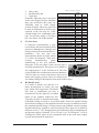
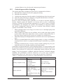
7.1.1 Profiling
Determination of ground surface
elevations in a field in order to
construct a profile map is necessary
for determining land leveling
requirements
and
placement
structures, etc.
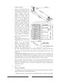
Every surveyor working with ‘PV
Pumping System’ should have, at a
minimum, an Abney level; a
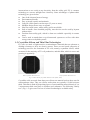
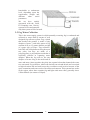
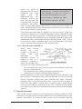
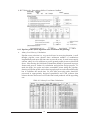
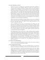
Fig. 7-1 Abney Level
surveying rod; a measuring tape (minimum of 30 meters); a carpenter’s level;
and a scientific calculator (capable of computing roots and powers of
trigonometric relations). This will allow the surveyor to determine elevation
differences, profiles, and area measurements. Some topographic mapping can
be accomplished with this equipment. For significant leveling work, however,
an engineer’s level and/or transit are often required. This equipment is not
often available to the surveyor. The theory and practice of land leveling is
beyond the scope of this manual. The surveyor should consult appropriate
references and obtain assistance from an engineer before undertaking
significant land leveling.
1. Abney Level: is a hand held instrument used in surveying which consists of a
fixed sighting tube, a movable spirit level that is connected to a pointing arm,
and a protractor scale. Abney Level is an easy to use, relatively inexpensive,
and, when used correctly, an accurate surveying tool. The Abney Level is used
to measure degrees, percent of grade, topographic elevation, and chain age
correction.
By using trigonometry the user of a Topographic Abney Level can determine
49