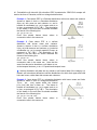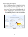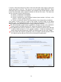
1
S an D iego S tate U niversity, Department of Geography National Taiwan University, Dept. of Bioenvironmental Systems Engineering SpaceTimeWorks, LLC January 2013 CONTENTS Preface................................................................................................................................... 1 PART I INSTALLATION OF THE SEKS-GUI PACKAGE.................................................................... 2 I.1. System Requirements....................................................................................................... 2 I.2. Items Related To the SEKS-GUI Package....................................................................... 2 I.3. Installation Notes.............................................................................................................. 2 I.4. Testing BMElib.................................................................................................................. 4 PART II INTRODUCTION TO SEKS-GUI............................................................................................ 5 Section II.A The SEKS-GUI Structure....................................................................................................... 5 Section II.B What information you need to run SEKS-GUI………………................................................... 6 1. Hard Data File............................................................................................................... 6 2. Soft Data File................................................................................................................ 7 3. Output Format File.......................................................................................................11 Section II.C Starting a SEKS-GUI Session............................................................................................... 14 PART III SEKS-GUI SCREENS........................................................................................................... 15 Section III.A Data Input ………………………………………………............................................................ 15 1. Splash Screen............................................................................................................. 15 2. “Choose a Task”.......................................................................................................... 16 3. “Import Hard Data Wizard” Screen – Part I................................................................. 18 4. “Import Hard Data Wizard” Screen – Part II................................................................ 20 5. “Import Soft Data Wizard” Screen – Part I................................................................... 21 6. “Import Soft Data Wizard” Screen – Part I (continued)............................................... 22 7. “Import Soft Data Wizard” Screen – Part II.................................................................. 23 8. “Output Grid Wizard” Screen....................................................................................... 24 9. “Data Exploratory Analysis” Screen – Part I................................................................ 26 ii Section III.B BME Analysis Screens in SEKS-GUI.................................................................................... 27 1. BME Exploratory Analysis…………………………………………………………………. 27 1.1 BME “Data Exploratory Analysis” Screen – Part II.............................................. 27 A. Introduction..................................................................................... 27 B. Instructions...................................................................................... 28 1.2 BME “Data Exploratory Analysis” Screen – Part III………..………..……………..33 A. Introduction..................................................................................... 33 B. Instructions...................................................................................... 34 2. Covariance Analysis………………………………………………………………………... 37 2.1 BME “Covariance Analysis” Screen – Part I……………..……………..……….… 39 2.2 BME “Covariance Analysis” Screen – Part II……………..……………………..… 44 3. “BME Prediction” Screen............................................................................................. 49 Section III.C Visualization in SEKS-GUI.................................................................................................... 54 1. “Visualization” Screen................................................................................................. 54 PART IV SEKS-GUI EXAMPLES ……………………………….............................................................62 1. BME S/T study of Total Ozone concentrations over the United States............................. 62 2. BME Spatial study of Arsenic in Bangladesh drinking water............................................. 64 PART V SEKS-GUI UTILITIES INCLUDED IN PACKAGE................................................................. 66 1. Data exchange with shapefiles: Converting shapefiles into text....................................... 66 2. Data exchange with shapefiles: Converting text into shapefiles....................................... 69 3. A start-up set of files for the creation of masking files....................................................... 72 PART VI Acknowledgements……………………………….................................................................... 74 PART VII BIBLIOGRAPHY................................................................................................................... 75 PART VIII LIST OF ABBREVIATIONS................................................................................................... 76 iii PREFACE Welcome to the Spatiotemporal Epistemic Knowledge Synthesis Graphical User Interface (GUI), or SEKS-GUI. This is a freely available package; it is currently the combination of the scientific software library BMElib (Bayesian Maximum Entropy library), and related GUI files. BMElib is a stand-alone software library for space-time modeling, prediction and mapping. This library implements innovative approaches in space-time statistics and introduce many new features for spatiotemporal analysis and Temporal Geographical Information Science (TGIS; see, Christakos et al., 2002). BMElib relies on correlating information to predict the attribute of interest at a specified set of spatial locations and time instances. For a typical space-time study, BMElib processes data sets of observations with space-time reference; it provides explicit information about estimates of underlying data trends; the user can model data correlations by fitting permissible (ordinary) covariance models to the raw data; and eventually performs attribute prediction. BMElib is a software library written in Matlab. Therefore, to use it as a stand-alone package, it is required that the user has a working knowledge of the Matlab command line. SEKSGUI is built with the user in mind. SEKS-GUI • provides a friendly interface for the BMElib library • eliminates the need to know programming in order to use it • introduces a framework that unifies all individual steps for modeling, prediction, mapping • includes utilities to wire the analysis output to other popular mapping tools This is the manual guide for the latest version of the GUI. For an initial familiarization or a “quick start” with SEKS-GUI, two examples are presented in PART IV towards the end of the manual. The examples are available to download from the SEKS-GUI website. We hope that you find this manual guide helpful when using the SEKSGUI package in your projects. We greatly appreciate your feedback on the ideas, features, functionality and aesthetics of SEKS-GUI. The current guide is an update of the original SEKS-GUI user manual for the first official version 0.6 that was made available in June 2006. Since then, SEKS-GUI has had some features added and numerous bugs fixed. The SEKS-GUI package is free software that can be used within the Matlab environment. Alexander Kolovos, Ph.D. SpaceTimeWorks, LLC 1 PART I INSTALLATION OF SEKS-GUI PACKAGE (BME Spatiotemporal Analysis Library & SEKS Graphical User Interface) I.1. System Requirements 1. Personal computer running Windows OS, Mac OS X, or Linux with Matlab version R2010a or newer pre-installed. As of 2013, the current version of SEKS-GUI has been tested successfully on Matlab versions R2007 and newer. It is possible that SEKS-GUI might run without issues on even earlier Matlab versions, however it will not run with versions earlier than Matlab 6.5. If you are unsure about the Matlab version you are using, you can check this software version by launching Matlab (see subsection 2.3 below). Then type on the command line: >> version and press the return key. The number you see should be 7.11 (R2010a) or higher. I.2. Items related to the SEKS-GUI package The following items are available for downloading: 1. “SEKS-GUIvX.Y.Zpackage.zip”. This is a compressed file that contains SEKS-GUI. The component vX.Y.Z of the file name stands for the software version. The version numbering uses the following convention: • X stands for major version • Y stands for main update • Z designates an update with bug fixes over previous versions 2. “SEKS-GUIvX.Y.Zdoc.pdf”. This is the present user’s guide for the current SEKS-GUI. 3. “SEKS-GUIexamples.zip”. A compressed file that contains the folder “GUI-Examples” with working examples of SEKS-GUI. I.3. Installation notes For installation of the SEKS-GUI package you need no administrative rights on your computer. Simply follow the steps below to move the package files to a desired position in your documents. Assume that you have downloaded the latest SEKS-GUI version in the compressed file “SEKS-GUIvX.Y.Zpackage.zip”. 1. Select a folder where the package will reside. Example: You can create a folder “SEKSGUIfolder” to store the package. In the Windows OS, this path can be “C:\[Your_WindowsOS_Path_To]\My Documents\SEKSGUIfolder” In the Mac OS, this path can be “/Users/[Your_Home_Folder]/Documents/SEKSGUIfolder” In this manual we assume that you store the package in a folder called “SEKSGUIfolder”. 2 2. Unzip the compressed file. The contents are the following items: i) “SEKS-GUIvX.Y.Z”: Folder that contains all the graphical user interface (GUI) files. ii) “startup.m”: A file with information so that the Matlab application can locate files. It is possible that your uncompressing application may have a default folder to place items (i) and (ii). Ensure that these items are eventually placed in the “SEKSGUIfolder”. If you downloaded the SEKS-GUI examples, add the “GUI-Examples” folder into the “SEKSGUIfolder”, too. After you complete these moves, you can delete, if you want, the zipped files you downloaded and any other folders that were created during this process. 3. Start Matlab and navigate its current working folder to the “SEKSGUIfolder” using the bar on the top of the Matlab Command window, which is the main window in the Matlab environment. Use the buttons on the top right hand side to locate the desired folder within your filesystem (Fig. I.1). Fig. I.1 Alternatively, you can perform the navigation using the Current Folder window (Fig. I.2) to the left of the Matlab Command window. If the Current Folder window is not showing, you can find it and select it under the “Desktop” menu of the Matlab main window, and it should then appear on the side of the main window. If this process has been performed once on a computer, the following time you launch Matlab again on the same computer it is possible that the “SEKSGUIfolder” location has been stored. Click the downward arrow on the right side of the Current Folder bar (Fig. I.1) at the top of the Matlab Command window. With this action, a list of the most recently visited folders is shown, so you can select the “SEKSGUIfolder” without Fig. I.2 having to navigate your way there again. 4. Once the Matlab path above the Command window indicates that you are in the “SEKSGUIfolder”, type “startup” at the Matlab command line and then press the Enter or the Return key. >> startup This is a SEKS-GUI command. It renders all of the material in the SEKSGUI folders accessible in your session by adding them into the Matlab Fig. I.3 search path. 3 If the command works correctly, then a confirmation message should display in the Matlab Command window (Fig. I.3). You are now ready to use SEKS-GUI and the BMElib library on Matlab. Steps 3 and 4 above must be performed every time you start Matlab, when you want to use SEKS-GUI in a session. Step 5 above may be skipped if you start Matlab from within the “SEKSGUIfolder”. This option is available for Windows OS users if you define a Matlab shortcut that starts from within this folder when invoked. This option is also available for Mac OS and Linux users, if you start Matlab from the command line of a terminal while in the “SEKSGUIfolder”. This information is slightly more advanced. Unless you are certain about your setup, follow step 5 to start and ensure the correct path to SEKS-GUI is set. I.4. Testing BMElib This is not a necessary step in the SEKS-GUI installation. It is a recommended action, though, the first time you ever run BMElib on a computer to ensure that important BMElib functions work properly on the particular hardware. 1. Start Matlab. The Matlab Command Window should appear. Make sure that Matlab already has the SEKS-GUI package in its path (steps 4 and 5 in previous Paragraph I.3). 2. Type “MVNLIBtest” in the command line of the Matlab Command Window and then press the Enter or the Return key. >> MVNLIBtest Wait a brief moment for some testing calculations to appear on the Matlab Command Window. You should see the message “test complete” at the bottom of the window soon afterwards. This message informs you that BMElib functions correctly on the computer. If any errors should appear, this is evidence that some key BMElib functions are not properly compiled for your computer architecture/software. In that case please contact the SEKS-GUI support to help you resolve the issue. 4 PART II INTRODUCTION TO SEKS-GUI Section II.A – The SEKS-GUI Structure SEKS-GUI implements the BME methodology for spatiotemporal analysis. The following graph is a flowchart of how this analysis works in SEKS-GUI. 5 Section II.B – What information you need to run SEKS-GUI The following information describes what you will need at hand before you begin working with SEKS-GUI. For your convenience, please read the current section before running the software, and prepare your material as described in the following guidelines. If you only wish to test-run the program, there exist built-in, full-scale examples in the SEKS-GUI package, so you do not need to have any additional files or information at hand. The locations of the example files you will be asked for during execution of the SEKS-GUI are provided in PART IV towards the end of this manual. SEKS-GUI enhances and facilitates your space-time analyses by enabling you to use the powerful BMElib software library in a user-friendly manner. Your investigation input is necessary to run SEKS-GUI. You can make optimal use of SEKS-GUI by having the requested input information available before you start your analysis. Depending on your available data and study types, 3 files containing information can be asked at different times: II.B.1. Hard Data File Based on the Knowledge Synthesis framework, hard data are exact measurements (i.e., data without significant uncertainty in their values for the purposes of your case study). This file should contain coordinates and attribute values provided in one of the following forms: ASCII (text) file, Microsoft Excel (.xls), or GeoEAS–formatted text file. On the SEKS-GUI screen where you are asked to provide hard data (see following Paragraphs III.A.3 and III.A.4) it is required that you specify the data file type as one of the above. The following notes and file formatting rules must be observed: I. If you choose to use a text file, values should be space- or tab-separated, occupy continuous lines, and there should be 1 datum information per line. Each datum line should display up to 3 spatiotemporal coordinates (up to 2 spatial coordinates in the purely spatial case, or up to 2 spatial coordinates plus 1 temporal in the spatiotemporal case) followed by the attribute value. The display in each line must be consistent with those of the other lines in the same file (e.g., if one line starts with the x-coordinate, then all lines in the file must start with the x-coordinate, too). Finally, you need to know the content of each column in your text file (e.g., x-coordinates are in the 1st column). II. If you use an Excel file, please ensure your information is in the first spreadsheet of the file (if there are more than one spreadsheets in the file). Values should be stored in neighboring cells, and each row should contain information for exactly 1 datum. The formatting rules are the same as in the previous case (I). III. If you will be using the GeoEAS format, then all you need to know is where your input file resides when asked, and how the data are positioned within the file. In particular, SEKS-GUI will ask you to specify the columns that contain the spatiotemporal coordinates and the attribute values. 6 II.B.2. Soft Data File Based on the Knowledge Synthesis framework, soft data are measurements associated with some known uncertainty. Provide an ASCII (text) or a Microsoft Excel (.xls) soft data file. I. In a text file, values should be space- or tab-separated, occupy continuous lines, and there should be 1 datum information per line. Each datum line should first display up to 3 spatiotemporal coordinates (up to 2 spatial coordinates in the purely spatial case, or up to 2 spatial coordinates plus 1 temporal in the spatiotemporal case) followed by the attribute soft information. The display in each line must be consistent with those of the other lines in the same file (e.g., if one line starts with the x-coordinate, then all lines in the file must start with the x-coordinate, too). Finally, you need to know the content of each column in your text file (e.g., x-coordinates are in the 1st column). II. If you use an Excel file, please ensure your information is in the first spreadsheet of the file (if there are more than one spreadsheets in the file). Values should be stored in neighboring cells, and each row should contain information for exactly 1 datum. The formatting rules are the same as in the previous case (I). When it comes to assimilating soft information, SEKS-GUI is a powerful tool that can accept and process a variety of types/categories of soft data. Only one type of soft data and one soft data file may be used in the same investigation, i.e., different types cannot be mixed in the same soft data file! If your study involves more than one soft data types you can convert them to the same single soft data type and store them in one soft data file for use in the investigation. In particular, types shown in the following in (a) and (b1) can be converted, e.g., into the soft data types exhibited in Examples 5 and 7 shown later in (b2) – interval soft data are essentially uniform distributions. Given any of the fully described distributions presented in (a) or (b1), the user can estimate in advance the distribution probability density p1A,p2A,...,pNA at a set of N values l1A,l2A,...,lNA of the quantity of interest. In this way, following the guidelines in either of the Examples 5 or 7 below, any soft data collection of mixed types can be stored in the same file for use in an investigation. Each of the following examples describes one of the different soft data types that can be used with SEKS-GUI. These include: (a) Interval soft data: Information is provided in terms of the lower and upper bounds of each datum, whose values may range uniformly anywhere in the given interval. Each line in the interval soft data file must contain the datum coordinates, followed by the lower interval bound, and then followed by the upper interval bound. Example: “xA yA zA lA uA” can be the line content that describes one datum A, which is located on a plane at location (xA, yA) at the temporal instance zA, and its value has an equal probability of being measured anywhere within the interval [lA,uA]. (b) Probabilistic soft data: Each datum is provided in the form of a probability density function (PDF) that describes the attribute probability distribution across all of its valid values. The PDF may be either fully known by virtue of its characteristics, or may be described by the user in terms of individual probabilities assigned to a pre-defined number of bins across the PDF span. Each line in the interval soft data file must contain the datum coordinates, followed by the appropriate description of the attribute input PDF. Several different soft data types fall in the probabilistic category. The examples in the following pages cover the spectrum of the acceptable probabilistic soft data forms in SEKS-GUI. 7 b1. Probabilistic soft data with fully described PDF characteristics: SEKS-GUI accepts soft data in the form of Gaussian, uniform or triangular distributions. Example 1: Case where PDF is a Gaussian distribution with known mean and variance. Assume a datum A that is a Gaussian distribution N(mA,vA) with mean mA and variance vA, and is located at coordinates (xA, yA) in space and at zA in time, as portrayed in Fig. II.B.1. The description of this datum in the soft data file should resemble the format of the following line: xA yA zA mA vA Excel files should feature these values in consecutive cells in the same row. Fig. II.B.1 Example 2: Case where PDF is a uniform distribution with known mean and variance. Assume a datum A that is a uniform distribution U(mA,vA) with mean mA and variance vA, located at coordinates (xA, yA) in a purely spatial 2-D case, as portrayed in Fig. II.B.2. The description of this datum in the soft data file should resemble the format of the following line: xA yA mA vA Excel files should feature these values in consecutive cells in the same row. Note that the same line above also describes a soft datum at xA, at the temporal instance yA in a 1-D spatial and temporal case. Fig. II.B.2 Uniform distribution soft data are very similar to soft interval data of the category (a). Indeed, soft intervals as defined are uniform distributions for which their upper and lower limits are known, rather than their means and variances. Example 3: Case where PDF is a triangular distribution with known mean and limits. Assume a datum A that is a triangular distribution T(u1A, mA, u2A), spans within the interval [u1A,u2A] and has a mean mA. The datum is located at coordinates (xA, yA) in space and at zA in time, as portrayed in Fig. II.B.3. The description of this datum in the soft data file should resemble the format of the following line: xA yA zA u1A mA u2A Excel files should feature these values in Fig. II.B.3 consecutive cells in the same row. 8 b2. Probabilistic soft data with user-described PDF in terms of probabilities at pre-defined bins. This is a useful alternative when: • the soft datum PDF falls in any other than the previously described shapes • you have PDF information in bins or range brackets • the available uncertain information exhibits a more complex behavior or PDF form Example 4: Case where PDF bins might have different sizes, and the PDF value is constant within a given bin. Α simple distribution of this type is portrayed in Fig. II.B.4. Assume that this distribution corresponds to a probabilistic datum A that is located at (xA, yA) on a plane and at temporal instance zA. The datum PDF has 3 bins, whose 4 limits are l1A l2A l3A and l4A. Within each of these bins, the PDF has corresponding constant values p1A p2A and p3A. The datum is described Fig. II.B.4 in 1 line, and corresponding data file entry should be similar to the following line: xA yA zA 3 l1A l2A l3A l4A p1A p2A p3A Excel files should feature these values in consecutive cells in the same row. When using data of this type, you can include different data with variable number of bins in the same file. That is, you can specify different number of parameters in each line entry. Example 5: Case where PDF bins might have different sizes, and the PDF value changes linearly within a bin. Α simple distribution of this type is portrayed in Fig. II.B.5. Assume that this distribution corresponds to a probabilistic datum A that is located at (xA, yA) on a plane and at temporal instance zA. The datum PDF has 3 bins, whose 4 limits are l1A l2A l3A and l4A. Within each of these bins, the PDF changes linearly from the initial value p1A and advances to values p2A p3A and p4A at the consecutive bin limits. The datum is Fig. II.B.5 described in 1 line, and corresponding data file entry should be similar to the following line: xA yA zA 3 l1A l2A l3A l4A p1A p2A p3A p4A Excel files should feature these values in consecutive cells in the same row. When using data of this type, you can include different data with variable number of bins in the same file. That is, you can specify different number of parameters in each line entry. 9 Example 6: Case where all of the PDF bins have the same size, and the PDF value is constant within a given bin. Α simple distribution of this type is portrayed in Fig. II.B.6. Assume that this distribution corresponds to a probabilistic datum A that is located at (xA, yA) on a plane and at temporal instance zA. The datum PDF has 3 bins, whose lower limit is l1A, its upper limit is l2A, and the distance between any two consecutive bins is dsA. Within each of these bins, the PDF has corresponding constant values p1A p2A and p3A. The datum is Fig. II.B.6 described in 1 line, and corresponding data file entry should be similar to the following line: xA yA zA 3 l1A dsA l2A p1A p2A p3A Excel files should feature these values in consecutive cells in the same row. When using data of this type, you can include different data with variable number of bins in the same file. That is, you can specify different number of parameters in each line entry. Example 7: Case where all of the PDF bins have the same size, and the PDF value changes linearly within a bin. Α simple distribution of this type is portrayed in Fig. II.B.7. Assume that this distribution corresponds to a probabilistic datum A that is located at (xA, yA) on a plane and at temporal instance zA. The datum PDF has 3 bins, whose lower limit is l1A, its upper limit is l2A, and the distance between consecutive bins is dsA. Starting from the lower limit, the datum PDF changes linearly from the initial value p1A and advances to values p2A Fig. II.B.7 p3A and p4A at the consecutive bin limits. The datum is described in 1 line, and corresponding data file entry should be similar to the following line: xA yA zA 3 l1A dsA l2A p1A p2A p3A p4A Excel files should feature these values in consecutive cells in the same row. When using data of this type, you can include different data with variable number of bins in the same file. That is, you can specify different number of parameters in each line entry. Based on the PDF definition, in the previous examples 4-7 the values used to describe the probabilistic nature of soft data are the PDF values at the corresponding bins, and not the actual probabilities for the bins. Instead, probabilities are geometrically represented by the area under the PDF in bins. The total area under a PDF must be equal to the total probability of the occurrence of each datum, i.e., it must be equal to 1. If you provide probabilistic data whose total probability is different from 1, then a warning is produced about such discrepancies. SEKS-GUI renormalizes the data in question to comply with the rule, and continues the investigation. It lies in the user’s discretion to provide meaningful data, in the sense that SEKS-GUI cannot tell whether any such discrepancies might be due to mistakes in the data entry process. 10 II.B.3. Output Format File This file contains information about the prediction grid. Once you provide the input data, you must then specify the nodes in space and/or time where you want SEKS-GUI to generate predictions. The prediction area limits depend on your needs and are left for you to define. The distance between the nodes depends on the scale at which it is sensible to obtain results. The same is true regarding the number of nodes to consider in each direction. It is common that the output area extends to a size that is similar to the spatiotemporal extent of the available data. If you request a very dense grid, then you request to see what happens at finer scales. However, specifying too many nodes between data locations might not reveal new information about the behavior of your attribute, and can incur unnecessarily high computational load for the prediction. If you specify nodes that extend farther away from the population of your observed data, then prediction might yield no results at all beyond some case-specific distance. This could happen when output grid nodes are too distant from the data to be correlated with them, according to the specifics of your study. This version of SEKS-GUI accepts orthogonal, regular grids as output grids. There may well be cases where your area of interest does not cover an orthogonal area similar to the output grid type, as, e.g., when data are only provided on a stretch whose spatial coordinates cross the designated output grid diagonally. It is likely then, based on the previous remark, that some nodes on the grid located further outside the data populated stretch may not be assigned an estimate if they cannot be correlated to the input information. This is an expected event and it should not be alarming: You can still make good use of the grid, and obtain estimates on as many nodes as this field’s correlation will allow on the grid. Nodes without estimates can be masked out of the map at a later stage using image manipulation software. This version of SEKS-GUI supports information for a custom orthogonal grid, whose characteristics should be provided by the user in an ASCII text file or a Microsoft Excel (.xls) spreadsheet. I. If you choose to use a text file, values in the file should be space- or tab-separated, occupy continuous lines, and there should be exactly 1 line dedicated to the information on each of the dimensions used. II. In case you use an Excel spreadsheet, please ensure your information is in the first spreadsheet of the file (if there are more than one spreadsheets in the file). Values should be stored in neighboring cells, and there should be exactly 1 row dedicated to the information on each of the dimensions used. The following page has details on defining the grid information within your input file. 11 The grid information in a file can be only one of the following types: (a) Grid limits and spacing between nodes in each dimension. (b) Grid limits and number of nodes in each dimension. (c) Lower grid limit (origin), number of nodes and node spacing in each dimension. (d) Coordinate information for an arbitrary number of nodes. (e) Spatial coordinates of a polygon vertices, and node spacing in each dimension. To show examples of grid specification by using the information types (a)-(c), assume the imaginary spatiotemporal grid illustrated in Fig. II.B.8. This grid features nx=4 nodes in the x-axis, ny=3 nodes in the y-axis and nt=2 nodes in the temporal axis. In addition, the grid ranges from xmin to xmax in the x-direction, from ymin to ymax in the y-direction, and from tmin to tmax in the temporal continuum. Also, for each of these directions, the node spacing is dx, dy, and dt, Fig. IΙ.B.8 respectively. Then, you can specify this prediction output grid in any of the following ways: Example 1: If you want to define the grid by providing type (a) information, specify a text file that contains corresponding information in the following manner: xmin dx xmax ymin dy ymax tmin dt tmax Example 2: If you want to define the grid by providing type (b) information, specify a text file that contains corresponding information in the following manner: xmin xmax nx ymin ymax ny tmin tmax nt Example 3: If you want to define the grid by providing type (c) information, specify a text file that contains corresponding information in the following manner: xmin nx dx ymin ny dy tmin nt dt If you use an Excel file as input, then represent each line as a different spreadsheet row, and place the line values into consecutive cells by starting at the first column. By selecting the output grid information type (d), you can specify an arbitrary number of locations to obtain prediction at. The benefit of type (d) specification is that output nodes need not be on a grid. In this case, prepare a text/Excel file where each line/row contains the prediction node coordinates. First specify the spatial coordinates in the x-axis and yaxis, as necessary. If you perform a space-time analysis, then specify the temporal instance, too. Example 4: Assume that you want prediction at two space-time locations A(ax, ay, at) and B(bx, by, bt). If you specify a text file with type (d) output grid information, it should contain the following two lines with the coordinates of the locations A and B: ax ay at bx by bt 12 Alternatively, you might want to obtain predictions within a specific area bound by a polygon. Select the output grid information type (e) to specify the polygon vertices and node spacing in all dimensions. For an example of grid specification by using the information type (e), assume the imaginary spatiotemporal grid illustrated in Fig. II.B.9. In the figure, a polygon with vertices P1, …, P5 contains nodes of an orthogonal grid. The node spacing is dx in the x-direction and dy in the y-direction. Each vertex of the polygon has spatial coordinates in the x and y dimensions as illustrated in Fig. II.B.9. You want to obtain predictions at the nodes inside this polygon in a space-time study, where the temporal interval spans from instances Fig. IΙ.B.9 tmin to tmax with temporal node spacing dt. Then, you can specify this prediction output grid in the following manner: Example 5: To specify the prediction grid with nodes that are included in the polygon P1, …, P5, as illustrated in Fig. II.B.9, provide type (e) information. Prepare a text file that contains one line for each polygon vertex. Start with any of the polygon vertices, and specify the vertex coordinates in the first line. Continue in a cyclical manner by specifying the neighboring vertex coordinates in the following line, until you have specified the coordinates of all vertices. In the immediate following line, specify the spatial node spacing in the orthogonal grid that is included in the polygon. Each one of the above lines in the input file must contain 2 values, one for each of the x and y axes. If you perform a space-time study, provide one more line with the temporal grid information as follows: Initial instance, time step, and final instance. According to the information shown in Fig. II.B.9, the output grid file should look as follows: p1x p1y p2x p2y p3x p3y p4x p4y p5x p5y dx dy tmin dt tmax If you use an Excel file as input, then represent each line as a different spreadsheet row, and place the line values into consecutive cells by starting at the first column. 13 Section II.C – Starting a SEKS-GUI Session 1. Start Matlab. The Matlab Command Window should appear. Ensure Matlab has the BMElib and SEKS-GUI packages in its path (perform steps 3 and 4 in earlier Paragraph I.3). 2. Once you know Matlab has the SEKS-GUI components in its path, you can navigate Matlab elsewhere and still run commands in these components from any other folder. Assume that you choose to remain within the “SEKSGUIfolder”. 3. You can start a SEKS-GUI session by typing “seksgui” in the command line of the Matlab Command Window as below (Fig. II.C.1), and then press the Enter or the Return key. >> seksgui The SEKS-GUI splash screen will automatically appear, thus starting a new SEKS-GUI session (see Paragraph III.A.1 in the following). All steps 1-3 in this paragraph must be performed every time you start Matlab, if you want to use SEKS-GUI in a session. Fig. II.C.1 4. To exit SEKS-GUI at any instance while it is running, you can push the “Main Menu” button on the SEKS-GUI window. Then push the “Exit” button in the Main Menu screen (see Paragraph III.A.2 in the following). You need to confirm the exit action, because exiting results in erasing all your data stored in the memory of that session (data saved in files are not affected). 14 PART III SEKS-GUI SCREENS Section III.A – Data Input III.A.1. Screen 1: Splash Screen Some general information is displayed (Fig. III.A.1). The screen shows for 4 seconds, and then it automatically closes. At this time, the program proceeds to Screen 2 so that the user may choose a task. Fig. III.A.1 15 III.A.2. Screen 2: “Choose a Task” You are presented with a list of available tasks. Make a choice by clicking on a line in the list, and the line will be highlighted. Then push the “Start” button to begin (Fig. III.A.2). Fig. III.A.2 “BME Spatiotemporal Analysis” uses the BME methodology. You can read information about the BME analysis and instructions for the BME-related screens in Section B of PART III. The “Visualization of existing SEKS-GUI output” option takes you to the “Visualization Wizard”, which is the last of the SEKS-GUI screens. If you have prediction results from previous SEKS-GUI analyses, then you can follow this path to reproduce maps of your results without having to go through all the analysis again. You can find a description of this screen’s features in Section D of PART III. 16 By selecting the “View BMElib code help pages” task, you access to the standard BMElib help pages. When the option is highlighted and “Start” is pushed, an external window is launched (Fig. III.A.3). This option displays the default help files for the BMElib function libraries (upper left hand window in Fig. III.A.3) and its individual functions (upper right hand window in Fig. III.A.3). You can view the same help information when you ask for help about a specific BMElib function name in the Matlab Command Window with the Matlab “help” command. This screen makes all of these help pages easily accessible through SEKS-GUI. When you select one group topic or one function from the lists in the upper part of the screen, the help text is displayed in the lower window. In the example of Fig. III.A.3, the lower screen window displays help about the bmeprobalib topic group. When done, push “Close Help” to close the help window. Fig. III.A.3 In the “Choose a Task” screen, the “About” button provides brief information about the SEKS-GUI version and contact information. Use the “Exit” button in the “Choose a Task” screen to terminate the SEKS-GUI session. Before SEKS-GUI exits, you are asked to confirm (Fig. III.A.4). Fig. III.A.4 17 III.A.3. “Import Hard Data Wizard” Screen – Part I In this screen you enter hard data information into the system. According to the theoretical knowledge synthesis framework, this type of information should consist of individual values or measurements that are considered to be accurate for the scope of your study. You are now asked to enter this information. If no such data are available, then push the “Next” button to skip Part II of the Hard Data Wizard and to be taken to the “Soft Data Wizard” screens (see details in following Paragraph III.A.5). 1. The hard data (HD) file can be an ASCII (text) file, an Excel (.xls) file, or a GeoEAS preformatted file, as explained in Paragraph II.B.1 earlier. If your study involves hard data, then you have to choose the data file type by selecting the appropriate one from the three available buttons (“ASCII text”, “Excel format” and “GeoEAS format”). Only one of them can be selected at a time (Fig. III.A.5). If you opt to go for the Excel format, your data need to be saved in the first spreadsheet (if there are multiple ones) or the single spreadsheet of the file. GeoEAS is one of the standard formats available for data files – select this button only if your HD are so formatted. Fig. III.A.5 18 2. Push the button “Browse for Hard Data file”. Be prepared to navigate to the folder where your hard data file is stored, and then select the desired file. After a successful choice, the data filename appears in the message area next to the button. Ensure you have a valid HD file at hand, as instructed in Paragraph II.B.1 earlier. SEKS-GUI can only perform a rudimentary check on the file content and warn the user about possible inconsistencies before taking the next step (Fig. III.A.6). It is up to the user to provide a suitable input file. Also, be cautious to Fig. III.A.6 provide accurate information, because SEKS-GUI cannot guess from raw input what plain numbers may stand for. If the “Cancel” button is pushed during navigation, then no HD file is selected and a related message appears. If a HD file is already chosen and the “Browse...” button is pushed again and, further, the action gets cancelled using “Cancel”, then the file formerly selected is cleared from memory and needs to be entered again using the “Browse...” button. If you return to this screen form a following one, then the HD filename is kept in memory. 3. Is this a spatial-only investigation? If yes, select the “Space-Only domain” option. If the button is pushed again, then it is deselected. The default is a deselected button and implies a spatiotemporal analysis. A mistaken choice may cause errors and inconsistencies with the data at a later point. Fig. III.A.7 4. When done, push the “Next” button to proceed (Fig. III.A.7). 19 III.A.4. “Import Hard Data Wizard” Screen – Part II 1. In this screen you enter details about your hard data file to continue. This screen appears only if a HD filename has been specified in the previous screen, i.e., only when hard data are used. Following the choice of the HD file, you now provide the column numbers where your attribute observations and their coordinates are found in the file, as Fig. III.A.8 shows. Provide a number in a box only if the corresponding coordinates are used, otherwise leave unused boxes empty. A maximum of 3 dimensions (time, if considered, must be included as the last of the reported dimensions) is currently supported by SEKS-GUI. Please make sure you have a valid HD file at hand, as instructed in Section II.B.1 earlier. Also be cautious to provide accurate information, because SEKS-GUI cannot guess from raw input what plain numbers in a file may stand for. If you work on a spatiotemporal investigation, the time column information must be entered as the last of the coordinates (i.e., in the y-axis box in the spatial 1-D case, or in the z-axis box in the spatial 2-D case). Fig. III.A.8 2. When done, push the “Next” button to proceed. If the “Back” button is pushed in the following screen, then SEKS-GUI returns to part I of the hard data wizard (Paragraph III.A.3). In that case, the last declared HD file name is kept in memory. 20 III.A.5. “Import Soft Data Wizard” Screen – Part I In this screen you enter soft data information into the system. According to the knowledge synthesis framework, this is information that entails some degree of uncertainty within the scope of your study. Such data and their associated uncertainty can be entered in one of the SEKS-GUI acceptable formats (see Paragraph II.B.2). If you have no soft data in your study, then push the “Next” button to skip Part II and to be taken to output grid definition screen (see step 8 ahead). If no input is present of either hard or soft data and the user attempts to continue, then a warning screen appears, and the user is prompted to start anew by choosing a task (figure III.A.2) or to exit SEKS-GUI. 1. As discussed in PART II, Section B.2, the soft data (SD) handled by SEKS-GUI can be interval data or probabilistic data. Choose among the SD options offered by SEKS-GUI by using to drop-down menu shown in the upper right hand part of Fig. III.A.9. Probabilistic SD can be probability density functions (Gaussian, uniform or triangular); alternatively, the SD probability densities can be provided as a series of constant values (histogram form) that define equal or variably sized bins; also, SD can be a series of values at the limits of equal or variably sized bins, where the values are assumed to change linearly between consecutive limits. Fig. III.A.9 2. When done, push the “Next” button to proceed. 21 III.A.6. “Import Soft Data Wizard” Screen – Part I (continued) This screen appears if only soft data and no hard data are used. 1. Enter in the upper box the number of dimensions involved in the current study (1, 2, or 3 – in a space-time analysis you must include the temporal dimension in this number). 2. Designate whether your investigation is in space-time or a spatial-only task. For spatialonly tasks, push the “Space-Only domain” button (Fig. III.A.10). If the button is pushed again, then it is deselected. The default is a deselected button and implies a spatiotemporal analysis. If you make mistakes in your selections, there might be errors and data inconsistencies at later points in the analysis. Fig. III.A.10 2. When done, push the “Next” button to proceed. 22 III.A.7. “Import Soft Data Wizard” Screen – Part II 1. Push the “Browse for Soft Data file” button to locate your SD file. Keep in mind the considerations of Paragraph III.B.2 about eligible formats for soft data files in SEKS-GUI. Be prepared to navigate to the folder where your soft data file is stored, and then select the desired file. After a successful choice, the data filename appears in the message area next to the “Browse…” button. Fig. III.A.11 shows an example where a file with Gaussian SD is specified. Ensure you have a valid SD file at hand, as instructed in Paragraph II.B.2 earlier. SEKSGUI can only perform a rudimentary check on the file content and warn the user about possible inconsistencies before taking the next step. It is up to the user to provide a suitable input file. Also, be cautious to provide accurate information, because SEKSGUI cannot guess from raw input what plain numbers may stand for. If the “Cancel” button is pushed during navigation, then no SD file is selected and a related message appears. If a SD file is already chosen and the “Browse...” button is pushed again and, further, the action gets cancelled using “Cancel”, then the file formerly selected is cleared from memory and needs to be entered again using the “Browse...” button. If you return to this screen from a following one, the SD filename info is kept in memory. Fig. III.A.11 2. When done, push the “Next” button to proceed. If the “Back” button is pushed in the following “Output Configuration” screen, then SEKSGUI returns to part I of the soft data wizard (Paragraph III.A.5). 23 III.A.8. “Output Grid Wizard” Screen In this screen you are prompted to specify the spatiotemporal (or spatial, in the spatial-only case) locations to obtain predictions. 1. Use the drop-down menu shown in Fig. III.A.12 to choose one of the available options: • For option A, provide limits and node distancing for each of the dimensions used. • For option B, provide limits and number of nodes for each of the dimensions used. • For option C, specify the grid origin (lower limit), number of nodes and the constant inter-node distance for each of the dimensions used. • For option D, specify an arbitrary number of locations by means of their coordinates. • For option E, provide a polygon to obtain predictions inside; specify the spatial coordinates of the polygon vertices and inter-node distance of the prediction nodes. Selection or re-selection of an input format from the drop-down menu will clear any output info file information previously provided by the user to prevent potential errors. For that reason the user needs to always perform the current step 1 before proceeding to the following step 2. Fig. III.A.12 2. Follow-up your choice in the previous step by specifying an ASCII or Excel text file that contains the necessary information in the appropriate format, as discussed in PART II, Section B.3. Push the “Browse for Output Info file” button. Be prepared to navigate to the folder where your output grid configuration file is stored, and select the desired file. After a successful choice the output grid info filename appears in the message area next to the “Browse...” button (see Fig. III.A.13). 24 It is up to the user to provide a suitable input file. Also be cautious to provide accurate information, because SEKS-GUI cannot guess from raw input what plain numbers may stand for. Selection or re-selection of an input format from the drop-down menu (see previous step 1) will clear any output info file information previously provided by the user to prevent potential errors. For that reason, always perform step 1 before proceeding to the current step 2. If the “Cancel” button is pushed during navigation then no output info file is selected and a related message appears. If an output info file is already chosen and the “Browse...” button is pushed again and, further, the action gets cancelled using “Cancel”, then the file formerly selected is cleared from memory and needs to be entered again using the “Browse...” button. If you return to this screen from a following one, the output info filename info is kept in memory. Fig. III.A.13 3. In the bottom part of the screen, you are prompted to state whether the attribute in your study can take negative values or not. SEKS-GUI automatically scans the input information to provide an initial answer, based on whether the user data contain negative numbers or not. However, if you know the attribute can span into negative values, then specify this information explicitly by selecting the “No” button. SEKS-GUI uses this response to prevent predicted distributions of positive-only attributes to extend to negative numbers. 4. When done, push the “Next” button to proceed. 25 III.A.9. “Data Exploratory Analysis” Screen – Part I In this screen you are not required to take any action. SEKS-GUI performs an initial assessment of your data set. A check for duplicate observations takes place, because duplicate or co-located coordinates result in covariance matrix singularities. The same adverse effect also occurs when data points are very close spatial neighbors. The current version of SEKS-GUI automatically detects close proximity and handles it as co-location. The definition of “close” is assessed individually for each separate investigation; it is independent of the spatial measurement units, and is rather estimated on the basis of the output grid dimensions, according to your specification in the previous Paragraph III.A.8. In this version of SEKS-GUI, co-located hard data in space/time are averaged, whereas soft data co-located with other hard/soft data are dealt with by slight random spatial displacements (i.e., soft duplicates are not removed from the set). Once the check has been performed, the results are displayed in the corresponding boxes on the screen. At this point you can push the “Next” button to proceed (Fig. III.A.14). Please wait until the calculations are finished. Do not proceed to the next screen while the “Please wait...” messages display in this screen’s boxes. Fig. III.A.14 Section III.B on the following page guides you on how to continue with BME investigations. 26 Section III.B – BME Analysis Screens in SEKS-GUI III.B.1. BME Exploratory Analysis III.B.1.1 BME “Data Exploratory Analysis” Screen – Part II A. Introduction BMElib operates correctly on normally distributed residual values of an attribute, i.e., on detrended information that follows a Gaussian distribution. The following 2 screens fulfill the objective of bringing your raw input information into the above suitable processing form. The first action that is taken is detection and removal of mean (or surface) trends in the data set to obtain the residual data values. In this screen the user obtains a mean trend from the data distribution. You may choose to proceed to the following screens without going through the mean trend calculation and removal. This option is not recommended by the theory, and may affect the prediction calculations leading to distorted or no results at all. Nonetheless, skipping the trend removal may be useful for testing purposes. Even if you do not remove a mean trend, you can use other features on the current screen, such as viewing the data distributions and statistics. For the detrending, Gaussian kernel smoothing is applied across the dataset. In this version of SEKS-GUI, the kernel searches for neighboring data within user-defined ranges in spacetime, and extracts the trend by applying a smoothing moving window. If any unusually high (or low) values exist in the data set, then the moving window may be biased by these values. In these cases, the smoothing operation might produce artifacts caused by extreme values in the data, and thus drastically affect the trend estimate. SEKS-GUI addresses this issue by identifying and isolating from the detrending process potential outliers in the user data. In particular, extreme outliers are excluded from the data distribution trend prediction using criteria based on the box plot graphical techniques. The data used for prediction stage are not altered by this process. Estimates of a mean trend rely on the use of single values, which imply the use of hard data values. In BME analysis, it is possible that your data set could contain a limited amount or no hard data at all. SEKS-GUI resolves this shortcoming by employing the soft data in trend estimation as follows: For the purpose of trend estimation, the means of the soft distributions (or the middle points of the soft intervals) are used to produce hard value approximations from the soft counterparts. This is a reasonable compromise to potentially insufficient information conditions. This approximation is also used in the following stage of covariance modeling, as will be shown in Paragraph III.B.3, because covariance analysis cannot use soft information either. However, the BME prediction stage assumes no approximations, and soft data are considered in full as specified to take advantage of the BME methodology unique features for integration of soft information. Based on the output grid size, the kernel smoothing radius is set by default to 1/10 of the shortest extent of all grid directions. The maximum search radius for data to contribute to the trend in space-time is adjustable by the user. The default starting values on the screen are estimated by the input data, and they correspond to half the size of the longest extents among all grid directions in space and time, respectively. 27 B. Instructions 1. The left hand side of the screen displays statistics about the data (Fig. III.B.1). Depending on the presence of hard and/or soft data, these statistics are based on the hard data and the soft data approximations, and refer to the whole data set. Statistics of subsets at individual temporal instances in the spatiotemporal case are unavailable. You choose from the dropdown menu whether the non-detrended (“Non-D”) or the detrended (“Detrended”) data set statistics are displayed. The latter are available only after a mean trend has been estimated, or after you have loaded a file with previously saved mean trend information about the current data set (see step 3 below). If you request statistics that are unavailable, then the data statistics boxes display the message “N/A”. Data statistics are only available for display of values and cannot be edited. Fig. III.B.1 2. If you are visiting this screen for the first time in a study, specify the desired maximum search radius for space and time (temporal maximum radius not available in purely spatial cases) in the “S-radius” and “T-radius” boxes, respectively, on the right hand side of the screen. These are the distances around each location within which the kernel smoothing algorithm searches for spatiotemporal neighbors to obtain a local average. Then, push the “Begin detrending” button to extract a mean trend from the empirical data (Fig. III.B.1). Detrending may take a while to complete depending on the amount of data to process. When you request to “Begin detrending”, a confirmation window warns you that any existing unsaved trend data are ignored. 28 Initial space and time radii (as appropriate) are automatically set by SEKS-GUI upon visiting this screen on the basis of the output grid dimensions, as specified in the “Output Grid Wizard” screen of Paragraph III.A.8. Modify the default values as needed to achieve the desired degree of smoothness in the estimated mean trend. The larger the radius value is, the more smooth appears the trend estimate. Keep in mind that there is no single actual trend to estimate. The outcome of this stage depends purely on your judgment, knowledge and intuition about your study problem. Please be patient and wait until the calculations come to an end. Matlab and SEKS-GUI can not respond during the calculation time to any other commands. Refrain from pushing buttons at this time, as these actions are queued and may result in unwanted events after the calculations are done. Calculations may require a lot of time to complete, depending on the volume of data and the hardware you are using. Upon completion of the calculations, you are prompted to save the trend estimation data in a file. If you consider the results satisfactory, it is strongly suggested to save them in a suitably named file. This action serves the case where you may later wish to return or re-run this study (see in the following how to load previously saved data). The data are saved in a Matlab format which has the ending “.mat” in the folder you specify, and can not be viewed independently unless they are loaded within the Matlab environment. If you decline to save the trend data but instead prefer to explore the detrending output first, you can save them anytime you are still on this screen by pushing the “Save trend data” button. 3. If you are returning to this screen or re-running the same data set study, you may wish to load a previously saved version of the mean trend. You might have a saved version, if you followed the preceding step 2 at an earlier time. In that case, when the screen appears push the “Load trend file” button. You are then asked to navigate in your filesystem to find the Matlab-formatted file ending in “.mat” where you previously stored trend data. Once Fig. III.B.2 29 selected, the file name appears in the message box (Fig. III.B.2) and the detrended data set statistics appear in the boxes on the left-hand side. Please ensure you provide appropriate input, because SEKS-GUI cannot guess on the file contents. 4. The message box on the upper part of the screen communicates useful messages and cannot be edited. 5. Use the drop-down menu next to the “Map Displayed” label to plot a variety of maps. At any time, you can request maps of: • All data locations • Hard data locations • Soft data locations • Markerplots of all data (hard data and soft data approximations) • Colorplots of all data (hard data and soft data approximations) • Non-detrended data distribution Once trend data are available, the following maps can also be created: • Detrended data distribution • Non- and detrended data distributions (Fig. III.B.3) • Mean trend of variable in space, or at a chosen t-instance in space-time (Fig. III.B.4) If data necessary for a particular request are not available, a message appears in the message box on the screen. Fig. III.B.3 30 Use the “Bars” drop-menu to plot the histogram with more or fewer bars as desired. Use the “t” slider (or write a suitable number in the “t” box) on the lower left hand side to view maps at a particular instance in time (not available in purely spatial cases). Fig. III.B.4 shows an example of displaying a trend map at time instance t=9. Activate or de-activate as desired the “Maps for all t” button to see time-aggregated maps of data locations and distributions or maps at user-selected instances, respectively (not available in purely spatial cases, or when requesting trend maps at individual instances). Use the “External figure” button to display future plot requests in an external, independent window when activated (Fig. III.B.5), or to return to the in-screen display when de-activated. When the “External figure” button is activated, it enables complete control of the plot by making use of Matlab plot tools (e.g., axes rotation, renaming, etc.). Also, this feature enables you to print the particular figure using the independent window menu. For more information on handling plots in separate figure windows, see Matlab Help. Fig. III.B.4 31 Fig. III.B.5 6. A more advanced feature for map presentations is plot masking, which requires some knowledge of Matlab programming. This is a useful feature if you would like to show the results that appear in part of your output area (e.g., by masking out the portion of a map outside the borders of a country). It is a more advanced operation because it requires that you provide a Matlab “.m” code file with the masking information. If you can program in Matlab, you can create a map that produces the desired mask over the output grid area by using suitable coordinates. See also Paragraph V.3 in this manual for a basic utility provided with SEKS-GUI to assist you in mask creation. Keeping this information in mind, you can push once the “Add mask to plots” button to activate this feature. You are then prompted to locate a masking code Matlab file in your computer filesystem. If you push this button accidentally, you can cancel the file search. If the button is activated, you can push it again to de-activate it. 7. When done, push the “Next” button to proceed. 32 III.B.1.2. BME “Data Exploratory Analysis” Screen – Part III A. Introduction BMElib operates correctly on normally distributed residual values of an attribute, i.e., on detrended information that follows a Gaussian distribution. This screen continues the task of bringing the user data into the required form after detrending of the data in the preceding step. In this screen, you review the Cumulative Density Function (CDF) of the detrended data, and you decide whether they need to undergo a transformation. This data transformation aims to reshape the detrended data set from the original space of values (original-space) into a space where their distribution resembles a Gaussian one (transformation-space). The transformations are based on the detrended hard data and soft data approximations set. If the study includes soft data, the actual soft information used in the predictions is consequently translated into the transformation-space based on the transformation choice. Your detrended data CDF is compared to a Gaussian distribution CDF that has the same mean and variance as the detrended data. The criterion to apply a transformation and to a satisfactory transformation is the measure of deviation of your detrended data CDF from the Gaussian CDF in the original-space and the transformation-space, respectively. For example, consider the case of a logarithmic transformation of your detrended data. The user data statistics in the log-space are displayed on the left hand side of the screen. The log-transformed detrended data distribution is checked for normality by comparing its CDF to the Gaussian distribution CDF defined by the mean and variance of the log-transformed detrended data. In SEKS-GUI you can choose among the following options: a. No transformation: The detrended data set is unaltered and you proceed to the prediction stage with data in the original-space. b. N-scores transformation (also known as Normal Scores or Gaussian Anamorphosis; Olea, 1999): The detrended data set is transformed to follow a Gaussian distribution of zero (0) mean and variance equal to 1. The transformed data values that will be used for prediction are in the N-score-space. Back-transformation is enabled by means of the transformation N-score matrix that establishes corresponding values between the original-space and the Nscore-space. It is possible that some extreme values in prediction may not backtransform correctly when using the N-score matrix. SEKS-GUI addresses this issue by using the following commonly used technique: Upper and lower value bounds are set in the transformation. These bounds are set individually for each investigation, depend on the data span in the particular study, and provide a cushion on which possibly extreme predictions can back-transform into the original-space. All of the above actions are performed automatically in SEKS-GUI and are seamless to the user. c. Box-Cox transformation: The detrended data set is tested with a series of power transformations based on a parameter λ that typically ranges in [-2,2]. The transformation eventually uses the value of λ that brings the data distribution closest to a Gaussian one. If λ=0, then the Box-Cox transformation is defined as the logarithmic transformation. The resulting data values that will be used in the predictions are in the Box-Coxspace. Backtransformation depends on the optimal λ value that was selected for the specific data set. 33 The Box-Cox transformation is only defined for positive data values. Since this transformation is applied on the detrended data set, it is highly likely that the detrended data will feature negative or zero (0) values. In the case of negative values, SEKS-GUI adds a constant to the detrended set so that all values to be transformed are positive. This constant is removed later from the predicted values prior to their back-transformation to the original-space. All of the above actions are performed automatically in SEKS-GUI and are seamless to the user. Finally, if under some scenario there exist values equal to zero (0) in the set, these must be approximated by an adequately small number before being subjected to transformation. This action prevents any numerically unacceptable requests to compute the logarithm of 0. Towards this goal, SEKS-GUI approximates by default any 0 values to 10-3, if the Box-Cox transformation is selected. SEKS-GUI enables you to modify this default mapping of 0 values anywhere into the range between 10-1 to 10-10 instead, so that you can adjust this mapping according to your data set. Example: If your data values range between 0 and 1, then it might be a wiser choice to map 0 as an even smaller number than the default 10-3 (e.g., you can specify 0 values to be mapped as 10-6). The above options are based on subjective criteria, your knowledge of your data, and your experience in this type of analysis. There are no absolute correct options, so you might need to try repeated analyses with different selections to understand better how a specific system functions. Each transformation type forces your original-space detrended data set into becoming a set of different values. Typically, the data in the transformed-space have different set characteristics and dynamics than the data in the original-space. Among other concerns, this might be a source of numerical issues at later stages. Ideally, explore whether it is meaningful enough to perform your analysis without transforming your data. If you need to do so, then SEKS-GUI provides you with practical options to handle transformation with a minimum amount of effort. SEKS-GUI suggests by default the use of a transformation when the maximum observed deviation between the detrended data CDF and the Gaussian CDF is larger than 10%. B. Instructions 1. The left hand side of the screen displays statistics on the data set (Fig. III.B.6). Depending on the presence of hard and/or soft data, these statistics are based on the hard data and the soft data approximations. You can choose from the “Data Statistics” dropdown menu the form of the data that statistics refer to. In this screen, options include: • Non-detrended data (“Non-D” in the menu, same as in previous screen) • Detrended data (“Detrended” in the menu, same as in previous screen) • Detrended, N-score transformed data (“D-NormSc” in the menu) • Detrended, Box-Cox transformed data (“D-BoxCox” in the menu). Statistics about the transformed data are available because transformations take place before the screen appears. In this way, all available forms of transformed data are available for comparison so that you can make an optimal choice. The data statistics are only available for display of values and cannot be edited. 2. The message box in the upper part of the screen communicates useful messages and cannot be edited. 34 3. Click on the drop-down “Transformation Menu” on the right hand side of the screen to decide the form of data to use at the prediction stage. The available options are: • No transformation • N-score transformation (“Use N-scores” in the menu) • Box-Cox transformation (“Use BoxCox” in the menu) This is an important selection in your investigation. As stated earlier, there is no absolute correct answer to your decision. Instead, one should rather consult the data in each individual study. You can always repeat your study using a different transformation type and compare the prediction results in the end, if necessary. 4. If you select the Box-Cox transformation, there may be an issue with 0 values in the detrended data set in the original-space. The transformation may require calculation of the logarithm of 0 and this corresponds to -∞. This is numerically unacceptable, so you are asked to provide a suitably small value to map 0 to in the original-space for transformation purposes. The approximation is left to your discretion, as discussed in the Introduction part of the current screen. A default mapping of 0 into the value 0.001 is assumed when the screen appears. You can adjust this mapping value with the slider on the lower right-hand side (Fig. III.B.6). If you make a choice other than the Box-Cox transformation, then your investigation is unaffected by the 0 mapping feature, and you can ignore the slider value. Fig. III.B.6 35 5. You can plot a variety maps from the “Map Displayed” drop-down menu. At any time, you can choose to view maps of: • Comparison of the detrended, non-transformed data CDF (red line in plot) against the normal CDF defined by the detrended, non-transformed data mean and variance (blue dashed line in plot). • Comparison of the detrended, N-score-space data CDF (red line in plot) against the normal CDF of mean 0 and variance 1 (blue dashed line in plot). • Comparison of the detrended, Box-Cox-space data CDF (red line in plot) against the normal CDF defined by the detrended, Box-Cox-space data mean and variance (blue dashed line in plot). • Histogram of the detrended, non-transformed data distribution (as in the previous screen). • Histogram of the detrended, N-score-space data distribution (Fig. III.B.7). • Histogram of the detrended, Box-Cox-space data distribution. Use the “Bars” drop-menu to plot the histogram plots with more or fewer bars as desired. Use the “External figure” button to display future plot requests in an external, independent window when activated, or to return to the in-screen display when de-activated. When the “External figure” button is activated, it enables complete control of the plot by making use of Matlab plot tools (e.g., axes rotation, renaming, etc.). Also, this feature enables you to print the particular figure using the independent window menu. For more information on handling plots in separate figure windows, see Matlab Help. Fig. III.B.7 6. When done, push the “Next” button to proceed. 36 III.B.2. Covariance Analysis In covariance analysis the goal is to investigate correlation patterns among the data. The following refer to space-time investigations. For purely spatial cases, ignore references to the temporal component. It is crucial to stress that correlations may differ at different spatiotemporal neighborhoods due to the nature of the field under investigation. In that sense, for example, a pattern that is modeled through a particular covariance function and applies in a specific spatial neighborhood may be inappropriate for another neighborhood on the same output grid. Correlation patterns also differ when one changes the scale of observation. For example, correlations among data in a large grid do not exhibit, in general, the same behavior as correlations in a more localized scale within the same grid. The effects of upscaling or downscaling are very important for prediction. Exercise caution, if your investigation includes action in different scales (see also Christakos et al., 2002). If this is the case, then you can address these considerations in SEKS-GUI by splitting your area of interest in spatial subdomains, within each of which a single correlation scheme can be assumed to apply throughout the subdomain. Clearly, it is highly recommended to have some general prior information in advance about the spatiotemporal correlations of the underlying field. Alternatively, it is strongly suggested to investigate earlier whether your domain is best examined by considering one correlation scheme throughout the domain, or by considering multiple subdomains with an appropriately different correlation for each one of the subdomains. In a subsequent step, compare the results of the two approaches (i.e., using a single grid with one covariance function versus using multiple subgrids within the same grid, each with a covariance function of its own) to conclude about the nature of the spatiotemporal correlations in the field. The SEKS-GUI covariance analysis for BME prediction covers the full extent of the specified output grid (see Paragraph III.A.8) in two stages, as follows: a. Explore all data pairs on the basis of distances between them. In particular, classify all pairs in lags of spatial and temporal distances. Then, compute the empirical (also known as sample or experimental) covariance value for each one of the distance classes. The user specifies how many of these classes to consider in space and time, and then computes the empirical covariance in them. b. Fit a model over the individual empirical covariance points calculated in stage (a) to obtain an explicit covariance expression in space and time. Similarly to the analysis in the detrending stage, only single individual values can be used in the covariance analysis. In the presence of soft data, SEKS-GUI includes them in the correlation analysis by using the soft data approximations (defined earlier as the means of soft distributions, or the middle point of soft intervals). This action is justified on the reasoning that the covariance of the soft data means is equivalent with the covariance of the soft data themselves (Christakos et al., 2002). The current version of SEKS-GUI offers basic anisotropy analysis features. Specifically, in stage (a) you can choose among 3 different directions to explore the sample correlations, namely the East-West or 0° axis, the North-South or 90° axis, and an all-directional analysis that assumes isotropy. You must consequently define an estimate of spatial and temporal ranges for the sample correlations. You can approximate values for these ranges, based on your knowledge of your data or the underlying process. If you have no such advance 37 knowledge, try repeated estimations of the empirical covariance for a series of range values. This experimentation can help you reveal how far the sample correlation extends across the spatial and temporal distance axes. To help you in this task, SEKS-GUI offers the convenience of setting variable numbers of space and time lags. At each one of these distance classes, correlations are investigated by means of the number of data neighbors to any other given datum that are found within the class. One value of empirical covariance is computed for each such class. Based on the previous, you can compute different values of the empirical covariance depending on the number of distance classes you assume in space and time. However, the computed covariance values depend on the amount of data neighbors that belong to each one of the lags you specify. If no neighbors exist in a particular lag, then a warning message appears in the Matlab Command Window to inform you that some space/time classes contain no pairs of points. This warning does not affect the use of the SEKS-GUI, as long as you can eventually adjust the parameters to obtain a satisfactory number of empirical covariance points to fit a model on. The numbers of spatial and temporal lags to use are reasonably in a balance with the data sample size. You are advised to proceed with caution at this point: A good knowledge of your data, and experimentation with the parameters for the correlation length and lag number can provide you with valuable insight for the purpose of computing the empirical covariance. For the creation of the covariance model in stage (b), choose up to 2 individual models to nest in each other from a selection of permissible covariance functions, and then adjust the covariance parameters for each of the selected nested models to achieve an optimal visual fit. These parameters are the covariance sill and range. The sill is the maximum value the model variance can take; if you specify more than one model to nest, then the sill is the sum of the nested models partial sills. The spatial and the temporal ranges are measures of how far the correlation spans in space and time, respectively. In case of nested models, the covariance model range is based on a combination of the nested components. You must provide SEKS-GUI with covariance information to proceed to following screens. The covariance has a natural maximum at 0 space/time lag. To understand this intuitively, think that each datum has a maximum correlation with itself, and this correlation reduces as one moves farther away in space and time. The covariance value at lag 0 equals the data set variance. 38 III.B.2.1. BME “Covariance Analysis” Screen – Part I 1. If you are returning to this screen or re-running the same data set study, you may wish to load a previously saved version of the empirical covariance information. You might have a saved version, if you followed steps 3-6 below at an earlier time. In that case, when the screen appears push the “Load data” button (Fig. III.B.8). You are then asked to navigate in your filesystem to find the Matlab-formatted file ending in “.mat” where you previously stored empirical covariance data. Upon successfully loading a pre-existing empirical covariance file for the current investigation, a message appears to acknowledge the action. Please make sure you provide proper input, because SEKS-GUI cannot guess on the file contents. 2. The message box on the upper part of the screen communicates useful messages and cannot be edited. 3. Make a choice about anisotropy in your analysis by selecting an option from the “Anisotropy: Covariance in” drop-down menu (Fig. III.B.8). You have the following 3 anisotropy options: • All-directions (isotropy assumption) • East-West (anisotropy along the 0° axis) • North-South (anisotropy along the 90° axis) The default selection is an all-directional isotropical analysis. Once the empirical covariance has been calculated in any of the direction options, you can choose to store the computed data immediately, or cancel saving and continue for the covariance in a different direction. After each calculation you are prompted to save the results. You can compute the empirical covariance in all available direction options, and then save all the results upon the last computation. 4. The maximum spatial correlation range box and the maximum temporal correlation range box can be edited by the user. These fields regulate the spatial and temporal extent of covariance computations, and indicate your guesses about the correlation space-time distance from any given location. Adjust the range values in repeated covariance calculations, until the data-based covariances provide you with insight about likely values of the actual correlation ranges in space-time. When you first visit this screen, SEKS-GUI applies default starting values for the ranges as follows: The initial maximum spatial correlation range is half of the eucledian spatial distance between the most remote data in the set; the initial maximum temporal correlation distance is half of the maximum data time span. Initial values are only provided as a guide for your analysis, and are no indication that SEKS-GUI understands the actual correlation mechanism in your study. An example of default values in boxes when you arrive at this screen is shown in Fig. III.B.8. The importance of knowing well your data is stressed again here. Observe the resulting empirical covariance plot to assess how well your range estimates approximate the correlation structure. 39 Fig. III.B.8a Fig. III.B.8b 40 SEKS-GUI prevents negative entries in the range boxes, and allows entry values of arbitrarily high size. To prevent specification of unlikely values by mistake, SEKS-GUI produces a message when your entry is in excess of your space-time domain physical size as follows: A warning is produced if the spatial range entry exceeds beyond 150% the distance between the data furthest apart in any spatial direction; also, a warning is produced if the temporal range entry exceeds beyond 150% the maximum data temporal span (the temporal feature is not applicable in the purely spatial case). In spatial analyses, the maximum temporal correlation range box is not editable (Fig. III.B.8b). 5. The lag sliders and edit boxes can be used interchangeably to define the number of lags at which empirical covariance values will be computed. You can request covariance estimates at any number between 2 and 30 lags in space and time. You must specify at least 2 lags. The upper limit of 30 lags is arbitrarily set by SEKS-GUI, and is well above values used in a typical analysis. For each one of the spatial and temporal directions, SEKS-GUI automatically distributes the lag distances logarithmically across the preset correlation range. This uneven distribution serves to obtain closer monitoring of the covariance behavior closer to the origin point s=0 and t=0, as is commonly desired in covariance analysis (see Olea, 1999). In spatial analyses, the temporal lag slider and edit box cannot be used (Fig. III.B.8b). 6. Start computation of the empirical covariance by pushing the “Get Empirical” button, after specifying the correlation range and lags parameters in earlier steps 4 and 5. Be patient and wait until the calculations come to an end. Calculations may take a while, depending on the volume of data in the data set and the hardware you are using. There is no indication on the screen regarding the calculation progress. Matlab and SEKSGUI cannot respond during that time to any other commands. Please refrain from pushing buttons at this time, as these actions are queued and may result in unwanted events or errors after the calculations are done. At the end of the computations, you are prompted to save the outcome data in a file. In case of computations in multiple directions, you can opt to save the empirical covariance data of all computations upon the completion of the last directional computation. If you consider the results satisfactory, it is recommended to save them in a suitably named file, as you may later wish to return or re-run this study (step 2 above explains how to evoke previously saved data). The data are saved in a Matlab format which has the ending “.mat” in the folder you will specify, and cannot be viewed independently unless they are loaded within the Matlab environment. Once prompted to save data, you cannot save them at a later point unless you repeat the computations. 7. After computation of the empirical covariance, you can use the “Plot” drop-down menu to view covariance plots. Choose at any time among the following plots: • Isotropic empirical covariance in all-directions (see Fig. III.B.9). • Empirical covariance in the East-West direction • Empirical covariance in the North-South direction • All empirical covariance points in one plot • All-directions, East-West, or North-South empirical covariances at s=0 (available only in space-time analysis) • All-directions, East-West, or North-South empirical covariances at t=0 (available only in space-time analysis) 41 Fig. III.B.9a Fig. III.B.9b 42 If data for a request are unavailable, a message appears in the message box on the screen. Use the “External figure” button to display future plot requests in an external, independent window when activated, or to return to the in-screen display when de-activated. When the “External figure” button is activated, it enables complete control of the plot by making use of Matlab tools (e.g., axes rotation, renaming, etc.). Also, this feature enables you to print the particular figure using the independent window menu. For more information on handling plots in separate figure windows, see Matlab Help. 8. When done, push the “Next” button to proceed. 43 III.B.2.2. BME “Covariance Analysis” Screen – Part II This screen (Fig. III.B.10) guides you to fit a covariance model to the empirical covariance information you obtained in the previous screen. This model may consist of one single pair of spatial and temporal model components, or it may be a nested model of more than one such pair of components. You can add as many pairs of components as you want. The current version of SEKS-GUI supports a model fitting approach based on visual inspection, rather than an automated one such as a least squares fit. To this purpose, simply select the components to assemble your model, and adjust their sill and range parameters. In general, it is recommended to fit a form as simple as possible that provides a satisfactory fit. Overfitting the empirical covariance is unnecessary because the empirical covariance itself is only an estimate of the underlying correlation structure. Accordingly, in the spatial-only case, your covariance model may consist of one single spatial model component, or it may be a nested model of more than one component. You must provide SEKS-GUI with a covariance model to proceed with your analysis. Either fit a model according to the steps 3-5 in the following, or load a previously saved model (step 9 in the following). Fig. III.B.10 44 1. The message box on the upper part of screen communicates useful messages and cannot be edited. 2. If you have simultaneously empirical covariances in different anisotropy directions, you can use the “Anisotropy: Covariance in” drop-down menu to select the desired empirical covariance to be the working covariance on the screen. As in the previous screen, the options allow for covariances in: • All-directions • East-West (0° axis) • North-South (90° axis) 3. Push the “Select a model” drop-menu under each one of the spatial and temporal component labels to add a corresponding component to your covariance model. SEKS-GUI offers the following options to use as individual model components: • Exponential • Gaussian • Cosine Hole • Sine Hole • Mexican Hat • Nugget • Spherical 4. Push the “Add Model” button after your selections in step 3. To add a model, you must specify both a spatial and a temporal component. If any of those components is not selected and the corresponding drop-down menu displays “Select a Model”, then no model is added, and a related message displays in the message box on the upper part of the screen. After you add a space-time model, the model components display as a new, single line in the model box under the “Add Model” button. To specify a nested model with more than one space-time component, follow the steps 3 and 4 from the beginning for as many nested space-time components as you wish. Fig. III.B.11a shows an example where two nested space-time components are specified; the first component consists of a spherical model in space and an exponential model in time, and the second component has an exponential model in space and a spherical model in time. These 2 components comprise the spatiotemporal model of choice in the specific example. Accordingly, in the spatial-only case, your need only specify at least one spatial model component. Fig. III.B.11b shows an example where two nested spatial components are specified; the first component is a nugget effect, and the second component is a spherical model. 45 Fig. III.B.11a Fig. III.B.11b 46 5. Specify positive values for the component parameters in the corresponding boxes inside the “Covariance Parameter” area to the right of the model box. In particular: • The sill box should contain the value of the space-time component sill that is currently highlighted in the model box. Sill values are normalized. Therefore, when you are done adding models, adjust the sills of all components of the covariance model so that their sum is 1. • The boxes in the “Spatial” row should contain values about the spatial component of the space-time component that is currently highlighted in the model box. The box on the left holds the spatial range value for all types of model components except for the following: For the Mexican Hat, the parameter is the first Mexican Hat model parameter. For the Sine Hole and Cosine Hole models, the parameter is the periodicity. The box on the right holds the second Mexican Hat model parameter, and is inactive when any other spatial component is selected. • The boxes in the “Temporal” row should contain values about the temporal component of the space-time component that is currently highlighted in the model box. The box on the left holds the temporal range value for all types of model components except for the following: For the Mexican Hat, the parameter is the first Mexican Hat model parameter. For the Sine Hole and Cosine Hole models, the parameter is the periodicity. The box on the right holds the second Mexican Hat model parameter, and is inactive when any other temporal component is selected. The nugget effect model has only the sill parameter, because the model represents the variance added to the data due to shorter range variation or measurement errors. For each model that you specify, SEKS-GUI provides sample default initial values for the model parameters based on the maximum spatial and temporal ranges in the problem. However, initial values are only provided as a guide for your analysis, and are no indication that SEKS-GUI understands the actual correlation mechanism in your study. Adjust the parameter values across all components of your spatiotemporal model to achieve an optimal fit by inspecting the covariance plot on the screen. In the spacetime analysis example of Fig. III.B.11a, the first of the 2 space-time components is highlighted, for which the sill is set to 0.55 variance units, the spherical model range is specified as 14 spatial length units, and the exponential model range is specified as 32 time units. In the spatial-only analysis example of Fig. III.B.11b, the first of the 2 spatial components is highlighted. This component is a nugget effect that has only a sill parameter. Its value is specified to be 0.75 variance units. 6. Push the “Remove Model” button to remove a spatiotemporal model you have added and is currently highlighted in the model box. To have an effect, at least one space-time component must be present in the model box. Simply highlight the model you want to remove in the model display box, and push the “Remove Model” button. Accordingly, in the spatial-only case, the “Remove Model” button has similar functionality. 7. During model fitting, every modification of the model components or parameters updates the plot on the screen accordingly. This provides you with feedback to guide you in the fitting process. At all times, you can choose to view any map of the following: • Empirical and modeled covariances • Empirical covariance only • Modeled covariance plot at lag s=0 (available only in space-time analysis) • Modeled covariance plot at lag t=0 (available only in space-time analysis) 47 Use the “External figure” button to display future plot requests in an external, independent window when activated, or to return to the in-screen display when de-activated. This feature is particularly useful in covariance fitting, because it enables you to inspect the fit quality in plot views that are not visible from the Matlab default plot viewing angle. When the “External figure” button is activated, it enables complete control of the plot by making use of Matlab tools (e.g., axes rotation, renaming, etc.). Also, this feature enables you to print the particular figure using the independent window menu. For more information on handling plots in separate figure windows, see Matlab Help. 8. Push the “Save model information” button after you have fitted a model to save your model details in a text file. You are prompted to choose a location to save this file. Its contents are similar to those shown in Fig. III.B.12a (for analysis in space-time) and Fig. III.B.12b (for spatial-only analysis). Retain the file intact, if you would like to re-use its saved content at a later time. The file contains information about one specific fitted model. You can fit different models and save their corresponding information in different text files. The sum of sills must not exceed 1 in your model. Otherwise, model information is not saved until you modify the sill parameter to satisfy this condition. 9. Push the “Load model information” button to navigate your file system and find a previously saved text file with space-time covariance information for SEKS-GUI. The file you load must be suitably formatted for SEKS-GUI to understand it correctly. It is recommended that you only load text files that you previously created by saving information in this screen after following step 8 above. Upon successfully loading a suitable file, the saved model details show in the corresponding boxes of the screen, and the model plot is displayed in the plot area of the screen. It is up to the user to provide a suitable input file. Also, be cautious to provide accurate information, because SEKS-GUI cannot guess from raw input what plain numbers may stand for. If you load a wrong file by mistake, try repeating again the process in this step. If this does not work, then repeat the covariance analysis steps by pushing the “Back” button to return to the previous screen. 10. When done, push the “Next” button to proceed. You must specify a covariance model to fit your empirical covariance before you can proceed to the following screen. The sum of sills must not exceed 1 in your model. Otherwise, SEKS-GUI cannot proceed to the following screen until you modify the sill parameter to satisfy this condition. Fig. III.B.12a Fig. III.B.12b 48 III.B.3. “BME Prediction” Screen In this screen you can select and initialize the type of BME prediction to be performed by SEKS-GUI. 1. Use the “Select a prediction type” drop-menu to specify the type of results you want (Fig. III.B.13). The options are: a. BME Mode (the mode of the prediction posterior PDF at each output grid node) b. BME Moments (the mean, variance and skewness coefficient of the prediction posterior PDF at each output grid node) c. BME PDF (the complete prediction posterior PDF at each output grid node) d. BME Confidence Intervals (the complete prediction posterior PDF and the userspecified percentile confidence interval at each output grid node) The above options are ranked with respect to the time required for the computations, starting with the fastest one and ending with the most time-consuming. To start BME prediction you must first select a prediction type. With the exception of the BME Mode computation type, each one of the gradually slower selections (c) and (d) above provides all of the information given by the previous, faster ones. BME Mode results cannot be extracted from the information in (b), (c) or (d). You can obtain all possible BME prediction outcomes by performing both the BME Mode and CI tasks. Fig. III.B.13 2. The message box on the upper part of screen communicates useful messages and cannot be edited. 49 3. If you request the BME Confidence Intervals prediction, use the “Percentile” slider or edit box to adjust the percentile for the computations. The default SEKS-GUI value is 68, which corresponds to the 68th percentile. Only one confidence level can be specified for each prediction task in SEKS-GUI. To compute confidence level results at additional percentiles, repeat computations for different percentile values in the slider or edit box. 4. For the prediction computations, adjust the number of closest data-neighbors of every prediction node location. Depending on the proximity and availability of hard and soft data, the number of closest neighboring observations that contribute to the prediction can be specified in the boxes under “Max Hard Data” and “Max Soft Data”. SEKS-GUI sets by default a maximum of 50 hard data and 3 soft data (Fig. III.B.13). You can edit the “Max Hard Data” and “Max Soft Data” edit boxes in the presence of hard and soft data, respectively. If one of these data categories is not present in an investigation, the corresponding box displays “N/A” and cannot be edited. It is reasonable to consider as many neighboring observations as possible when you predict the attribute value at an unsampled location. However, considering too many data may significantly slow down the prediction computations. This is particularly evident when you request to account for a large amount of soft data neighbors, if soft data are present. In general, prediction may become significantly slower if more than a few (about 4-5) soft data are considered at a time. Adjust the maximum neighboring data number accordingly before you start the prediction computations. You can also try repeated prediction computations with different parameter values to compare results and computation times. The edit boxes for the “Max Hard Data” and “Max Soft Data” parameters accept positive integer numbers. Any different entry is unacceptable and produces an error message window. Any positive integer is accepted in the “Max Hard Data” edit box. However, if you specify a value larger than 100, you are warned about the seemingly large number as a precaution to prevent potential typing errors. Any positive integer is accepted in the “Max Soft Data” edit box. However, if you specify a value larger than 5, you are warned about the seemingly large number as a precaution to prevent potential typing errors. 5. Adjust the spatial range parameter for the prediction in the edit box under “Max S Range” label. This parameter regulates the maximum spatial distance from the current prediction location within which BME searches for contributing data neighbors. SEKS-GUI sets a default starting value for this parameter based on the spatial range of your covariance model component with the largest sill. The initial value is only provided as a guide for your analysis, and is no indication that SEKS-GUI understands the actual spatial correlation mechanism in your study. The “Max S Range” edit box accepts positive numbers. Any different entry is unacceptable and produces an error message window. Any positive number is accepted in the “Max S Range” edit box. However, if you specify a value larger than 150% of the output grid largest side size, you are warned about the seemingly large number as a precaution to prevent potential typing errors. 6. (Applicable only in spatiotemporal analysis) Adjust the temporal range parameter for the prediction in the edit box under “Max T Range” label. This parameter regulates the maximum temporal distance from the current prediction location within which BME searches 50 for contributing data neighbors. SEKS-GUI sets a default starting value for this parameter based on the temporal range of your covariance model component with the largest sill. The initial value is only provided as a guide for your analysis, and is no indication that SEKS-GUI understands the actual temporal correlation mechanism in your study. In the purely spatial case, the corresponding box displays “N/A” and cannot be edited. The “Max T Range” edit box accepts positive integer numbers. Any different entry is unacceptable and produces an error message window. Any positive integer number is accepted in the “Max T Range” edit box. However, if you specify a value larger than the time span of the data set, you are warned about the seemingly large number as a precaution to prevent potential typing errors. 7. (Applicable only in spatiotemporal analysis) Adjust the spatiotemporal metric parameter for prediction. This parameter shows in the edit box under “S/T metric parameter”, and is used as a key to define how spatiotemporal distance is computed between two spatiotemporal coordinates. This spatiotemporal distance is given by the relationship: [S/T distance] = [Spatial distance] + [S/T Metric Parameter]*[Temporal distance] There are no guidelines for setting this parameter. You can experiment with different values to define the case-specific spatiotemporal distance as a function of the distances in space and time. SEKS-GUI sets a default starting value for this parameter as the ratio of the initial values of the maximum spatial range over the maximum temporal range (Fig. III.B.13). The initial value is only provided as a guide for your analysis, and is no indication that SEKS-GUI understands the actual correlation mechanism in your study. In the purely spatial case the corresponding box displays “N/A” and cannot be edited. The “S/T metric parameter” edit box accepts positive numbers. Any different entry is unacceptable and produces an error message window. 8. Push the “Begin Prediction” button to start the BME prediction computations. Be patient and wait until the computations come to an end. Matlab and the SEKS-GUI cannot respond during that time to any other commands. It is recommended to refrain from pushing other SEKS-GUI buttons at this time, as these actions are queued and may result in unwanted events or errors after the computations are done. Computations may take a lot of time, depending on the volume of data in the data set and your computer specifications. For your convenience, the message box displays the progress in calculations (Fig. III.B.14). No results can be viewed before the successful termination of the calculations and prior to advancing to the visualization screen. If you need to terminate the computations before the completion of the prediction process, you can click on the Matlab Command Window outside the GUI window, and subsequently press the sequence of keyboard keys: <CTRL-C>. If you do so, the Matlab Command Window displays some error messages related to the premature termination of the calculations; in the GUI window, the progress counter in the message box stops, which indicates that prediction is halted. The prediction progress counter in the message box might come to a halt before the “Prediction completed” message appears in the message box. If error messages appear in the main Matlab Command Window, or the counter indicates the task has stalled, then prediction computations have been probably interrupted. SEKS-GUI cannot inform or warn you explicitly, if such an event occurs. Sudden prediction interruption is most likely caused by unexpected numerical issues during computations. You can try to resolve this issue by attempting to re-adjust some prediction parameters. Typical reasons for interruption can include: 51 Fig. III.B.14 • Singularities in the covariance matrices: In this case, try revising your selected covariance model by revisiting the covariance analysis stage described in Paragraph III.B.2. • Limited amount of data for prediction: In this case, try increasing the maximum number of hard data neighbors you use and/or decreasing the maximum number of soft data neighbors. You can do this by adjusting the existing numbers in the “Max Hard Data” and “Max Soft Data” edit boxes; then, restart the prediction task. After BME prediction is complete at all of the output nodes in your specified output grid, SEKS-GUI calculates the moments (mean, variance and skewness) of the prediction PDFs, if applicable. Consequently, SEKS-GUI back-transforms automatically all the prediction information into the attribute’s original-space, if transformation has been applied to the initial data set. All results are arranged in SEKS-GUI variables that you are prompted to save in an output file upon completion of the computations. If a transformation has been applied to the data and moments have been calculated using any of the choices (b), (c) or (d) of the earlier step 1, the following apply for each prediction node: • The first moment (mean) of the raw results in the original-space is the backtransformed mean of the BME mean in the transform-space. • The second moment (variance) in the original-space is based on the BME variance in the transform-space, but it is not the direct backtransform of the BME variance. In particular, the variance value in the original-space is rather a measure of the variance in the transform-space. This measure is obtained by backtransforming the standard deviation value from the transform-space into the original-space. 52 • The third moment (PDF skewness) cannot be meaningfully backtransformed into the original-space, and it is therefore unavailable in the original-space when you request only the BME Moments [choice (b) in step 1 above]. If you specified the BME PDF or Confidence Intervals prediction types (c) or (d) in step 1, respectively, then the BME posterior PDF is included in the results and can be backtransformed into the original-space. In this case, skewness values are available in the original-space and they are calculated based on the backtransformed PDF. Upon completion of prediction computations you are prompted to save the outcome in a file. You can do so, or you can skip this action and run additional prediction tasks. Matlab retains prediction results in the background. At any point after a prediction task is completed, by saving the results you actually save all output to that point since visiting the BME prediction screen. To save BME prediction results, you can alternatively push the “Save output” button, as explained in the following step 9. 9. Push the “Save output” button to store the BME prediction results in a file. It is strongly recommended that you save your results in suitably named files, as you may later wish to return or re-run a study. The data are saved in a Matlab format which has the ending “.mat” in the folder you specify, and cannot be viewed independently unless they are loaded within the Matlab environment. You can run multiple prediction tasks and then push the “Save output” button to store all prediction results to this point in a single file. If you leave the screen without saving, BME prediction results may be lost upon returning to this screen. You can only save these results while you are at the present screen. For computations with large data, keep in mind that Matlab retains all prediction results in the background. Whether you save it or not, this information can accumulate and temporarily occupy disk space until you quit Matlab. 10. When done, push the “Next” button to proceed to the visualizations. For instructions on this screen proceed to Section III.D. 53 Section III.C – Visualization in SEKS-GUI III.C.1. “Visualization” Screen SEKS-GUI offers a bundle of mapping options to display the BME prediction results. This screen can be accessed from the prediction screens (Paragraph II.B.3 for the BME analysis), or directly from the “Choose a Task” screen (Paragraph III.A.2) if you have prediction output saved from previous investigations. 1. The message box on the upper part of the screen communicates useful messages to the user and cannot be edited. Upon loading this screen, the message box indicates whether there is any prediction output available in Matlab memory. If no such output is available, you are prompted to load a suitable file with previously prediction information (Fig. III.C.1). You can create such files according to steps 8 or 9 in Paragraph II.B.3 for the BME analysis. Fig. III.C.1 2. By pushing the “Load SEKS-GUI output file” be prepared to navigate to the folder where your SEKS-GUI prediction output file is stored, and then select the desired file. After a successful choice, the message box informs you about the available prediction data to work with. You can repeatedly load files with prediction information from different investigations. 54 Fig. III.C.2 3. Once prediction output data are available to the SEKS-GUI, you can choose from a series of maps from the drop-down menu under “Map Displayed” (Fig. III.C.2). Depending on the available results, choose at any time to view one of the following maps: (the type of results necessary for the particular map is printed in italic) • The mean of the prediction posterior PDF at each output grid node – see Fig. III.C.3. BME (Moments, PDF, or Confidence Interval) results required. • The mode of the prediction posterior PDF at each output grid node. BME Mode results required. • The prediction error variance (the variance of the prediction posterior PDF at each output grid node). BME (Moments, PDF or Confidence Interval) results required. • The prediction standard deviation (the standard deviation of the prediction posterior PDF at each output grid node). BME (Moments, PDF or Confidence Interval) results required. • The skewness of the prediction posterior PDF at each output grid node. BME (Moments, PDF or Confidence Interval) results required. • The actual probability density functions (PDFs) produced by the BME predictions at pre-selected output locations. The PDFs are projected vertically on a map of the output grid (Fig. III.C.4). The current SEKS-GUI version supports display of PDFs at pre-selected locations throughout the output grid to avoid cluttering the plot. BME PDF or Confidence Interval results required. • The size of the BME prediction confidence intervals (at the user-selected interval level as specified at step 3 in Paragraph II.B.3). The value at each output grid location on this map is the difference between the attribute values at the confidence interval bounds. For each prediction location, this map displays the width of attribute 55 values within which the predicted attribute is expected to be found at the selected confidence level. BME Confidence Interval results required. • The map of the lower limit values of the BME prediction confidence intervals (at the user-selected interval level as chosen on Screen 13, where 68% is the default) at each output grid node. BME Confidence Interval results required. • The map of the upper limit values of the BME prediction confidence intervals (at the user-selected interval level as chosen on Screen 13, where 68% is the default) at each output grid node. BME Confidence Interval results required. • The map of the BME prediction PDF value at the confidence interval limits at each output grid node. BME Confidence Interval results required. Fig. III.C.3 If data necessary for a particular request are not available, a message appears in the message box on the screen. Use the “t-Instance” slider (or write a suitable number in the “t-Instance” box) to view maps at any temporal instance from the ones included in the output grid specifications (Fig. III.C.3). The “t-Instance” slider and the edit box are disabled in the purely spatial case. Use the “PDF scale” slider (the corresponding box is read-only) to scale the actual size of the displayed PDFs on the graph (Fig. III.C.4). PDFs are projected on the map in a way that might cause the individual PDF plots to interfere due to their size. With the scaling feature you can achieve an optimal visual result for presentation purposes. Choose a scaling level by specifying one of the following factors in the slider: 10-7, 10-6, 10-5, 10-4, 0.001, 0.005, 0.01, 0.05, 0.1, 0.5, 1, 5, 10, 50, 100, 500, 1000, 104, 105, 106, and 107. 56 Fig. III.C.4 Use the “External figure” button to display future plot requests in an external, independent window when activated, or to return to the in-screen display when de-activated (as shown earlier in Paragraph III.B.1 and Fig. III.B.5). When the “Plot external figure” button is activated, it enables complete control of the plot by making use of Matlab tools (e.g., axes rotation, renaming, etc.). Also, this feature allows the user to print the particular figure using the independent window menu. For more information on handling plots in separate figure windows consult Matlab Help. 4. Use the “Fixed color scale” button to plot the eligible maps in a particular color scale, so that, e.g., maps of the same attribute can be compared at different temporal instances. The button toggles between activation and de-activation when pushed each time. Upon activating the button the first time, you have to set the lower and upper bounds of the color scale. Inspect your maps, choose the desired bounds, and specify the lower bound in the box next to the “Color Scale Min” tag, and the upper bound in the box next to the “Color Scale Max” tag. The following map you request will display within the color scale you specified. Fig. III.C.5 has an example of setting the color scale to range within the attribute values of 290 and 350. Compare to the attribute default illustration in Fig. III.C.3. In this example, any attribute values lower than 290 are shown in the color scale bottom color (white), and attribute values higher than 350 are shown in the color scale ceiling color (black). When the button is de-activated (by pushing it again when activated), bound indications disappear from the boxes and the boxes are disabled. However, if bounds have been previously defined they remain in the memory. Then, if you re-activate the “Fixed color scale” button, the last bounds set earlier reappear in the boxes. You can modify the bounds values as desired when the button is activated and boxes are enabled. 57 It may occur that the button is activated and one (or both) of the bound boxes does not contain any value. In this case, if you request a map that makes use of the fixed color scale, then an error message appears to indicate the issue; still, the requested map is created and the color scale for the map is automatically set to the default. You have the option to either de-activate the button or define properly the color scale bounds in the boxes. Fig. III.C.5 58 5. Use the “Save map data as text” button in the lower left hand screen corner to export the current map data in a text file. This way you can use results outside SEKS-GUI. When pushing the button, be prepared to navigate in your computer to the location where you want to save this information, and to specify a filename for the text file to save. The output text file has 4 columns with the following format: • Column 1 contains the X coordinates. • Column 2 contains the Y coordinates. • Column 3 contains the current temporal instance (same number in all lines), or the number 1 if this is a spatial-only case. • Column 4 contains the value of the map attribute at the corresponding coordinates. The number of lines in the file is equal to the number of output nodes on the spatial prediction grid. In a spatiotemporal case, you can export a time series of the output in text files by repeating the exporting process for a range of temporal instances. The “Save map data as text” button is available for all types of maps in the visualization screen except for the BME prediction PDF maps at pre-selected output locations. When Matlab cannot obtain an estimate at a node, it produces a result for that node that is called a NaN (acronym for “not a number” quantity). If NaNs are detected in the results during the exporting process, SEKS-GUI replaces them with the value -99999. If for any reason the output at a prediction node is a complex (nonreal) number, SEKSGUI exports only the real part in the text file and skips the imaginary part. Fig. III.C.6 59 6. Use the 2 buttons under the tag “Space to plot output” to choose whether to display the eligible maps in the original-space (click on “Original space”) or the transformation-space (if a transformation was used to obtain the estimates – click on “Transformation space”). When you enter the screen, the default choice is map display in the original-space. The buttons “Original space” and “Transformation space” are mutually exclusive: Only one of these two can be active at a time. The maps in the original-space are the back-transformed estimates with the mean trends restored at the prediction locations. The moments that are shown are based on the raw estimated PDF moments, which have been back-transformed and the mean trends at these locations have been restored. The maps in the transformation-space contain detrended data that come directly from the raw estimated PDFs. Therefore, in the transformation-space maps the mean trend is not restored; see Fig. III.C.6 and compare it to Fig. III.C.3. 7. Use the “Transformation Info” button to review the transformation type and its characteristics, if any has been applied on the initial data set that you used for prediction. This button only causes information to be displayed in the message box. If an N-scores transformation has been applied to detrended data, the message box shows the range of detrended data values that have been used to define the transformation; see Fig. III.C.7, and the discussion in the Introduction part of Paragraph III.B.1.2). If a Box-Cox transformation has been applied to detrended data, the message box shows the value of the parameter λ that was specified for the transformation (see the discussion in the Introduction part of Paragraph III.B.1.2). Fig. III.C.7 60 8. A more advanced feature for map presentations is plot masking, which requires some knowledge of Matlab programming. This is a useful feature if you would like to show the results that appear in part of your output area (e.g., by masking out the portion of a map outside the borders of a country). It is a more advanced operation because it requires that you provide a Matlab “.m” code file with the masking information. If you can program in Matlab, you can create a map that produces the desired mask over the output grid area by using suitable coordinates. See also Paragraph V.3 in this manual for a basic utility provided with SEKS-GUI to assist you in mask creation. Keeping this information in mind, you can push once the “Add mask to plots” button to activate this feature. You are then prompted to locate a masking code Matlab file in your computer filesystem. If you push this button accidentally, you can cancel the file search. If the button is activated, you can push it again to de-activate it. 9. The visualization screen is the last one in the series of the SEKS-GUI functions. Push the “Back” button to return to the previous screen, or push the “Exit” button to exit SEKS-GUI. If you arrived at the visualization screen after the prediction screen, and, in addition, you loaded output from a different investigation, then the “Back” button sends you to the “Choose a Task” screen of the SEKS-GUI main menu. 61 PART IV SEKS-GUI EXAMPLES If you downloaded the file “SEKS-GUIexamples.zip”, then you can run example test cases to get familiarized with the SEKS-GUI environment. The examples package features two examples that are presented in the following; namely, a spatiotemporal study of Total Ozone concentrations over the United States (of which snapshots at various stages have been used as figures in this guide), and a spatial-only investigation of Arsenic concentrations in the Bangladesh groundwater. In the following, assume that you create a folder “GUIexamples” in the folder “SEKSGUIfolder” (see Paragraph I.3, “Installation Notes”), and that you save the contents of the compressed file “SEKS-GUIexamples.zip” in “GUIexamples”. 1. BME S/T study of Total Ozone concentrations across the United States 1. All the information regarding this study is located in the folder: “GUIexamples/001-TotalOzoneUSstudy-ST” Please navigate Matlab into this folder first when requesting the input/output files in the following. 2. Start Matlab and SEKS-GUI, and when prompted for information at the appropriate screens provide the following files and input: BME analysis The task choice in the “Choose a Task” screen is “BME Spatiotemporal Analysis”. Highlight the task and push the “Start” button to continue. Hard Data: Use “Ozone-1-Input-HD.txt” in ASCII text format. This study is in the space/time domain. Longitude (x-Axis, in degrees) is in data file column 1 Latitude (y-Axis, in degrees) is in data file column 2 Day (temporal reference: date in July, 1988, in z-Axis) is in data file column 3 Ozone concentrations (in Dobson Units) are in data file column 4 Soft Data: There are Gaussian PDF soft data in “Ozone-2-Input-SDGaussianPDF.txt” in ASCII text format, and appropriately formatted as follows: Longitude (x-Axis, in degrees), in data file column 1 Latitude (y-Axis, in degrees), in data file column 2 Day (temporal reference: date in July, 1988, in z-Axis), in data file column 3 Mean of Ozone concentrations soft PDF (in Dobson Units), in data file column 4 Variance of Ozone concentrations soft PDF (in [Dobson Units]2), in data file column 5 62 Output Grid: The example prediction grid is described in terms of grid limits and node spacing. It is stored in “Ozone-3-Input-OutGrid.txt”. Ozone has positive-only values. The file requests prediction in a temporal span of 5 consecutive days, from July 6 to July 10, 1988. The mean trend is stored in the Matlab file “Ozone-4-MeanTrend.mat”. The default parameter values that appear on the detrending stage of the exploratory analysis screen have been used to obtain the trend. The Total Ozone data in the present example have been subjected to an N-scores transformation prior to proceeding to the covariance analysis. For empirical covariance information, use the “Ozone-5-EmpiricalCovariance-Nsc.mat” Matlab file. The covariance estimate has been computed by specifying maximum correlation ranges of 30 degrees in space and 5 days in time, and by requesting computation in 8 spatial and 7 temporal lags. A spatiotemporal covariance model has been fitted with 2 nested components. The model details are stored in the text file “Ozone-6-CovarianceModelInfo-Nsc.txt”. Load this model information, but also play with the values provided here and the SEKS-GUI sill/range adjustment tools to familiarize better with the interface. The BME prediction output is stored in the “Ozone-7-Output-BmeModCI-Nsc.mat” Matlab file. The output file contains the results of two tasks, namely the BME Mode and the BME Confidence Interval (at the 68 percentile) prediction tasks. For these results, a maximum of 50 hard data and 3 soft data have been used; also, a maximum spatial range of 50 degrees and temporal range of 6 days have been specified to define the prediction neighborhoods, and the spatiotemporal metric parameter value was set to 0.3. You can use the output file contents directly by advancing to the “Visualization” screen, or by loading the file at any time within the visualization screen to produce the Total Ozone BME study maps. 63 2. BME Spatial study of Arsenic in Bangladesh drinking water 1. All the information about this study is located in the folder: “GUIexamples/002-ArsenicBangldeshStudy-S” Please navigate Matlab into this folder first when requesting the input/output files in the following. For the Arsenic study there are masks to use when you produce maps of the prediction area. The provided masks display the borders of Bangladesh and the surrounding countries. You can use masking information for the mean trend maps, and the prediction maps. This information is stored in the folder “Arsenic-MapsMask”. Simply guide SEKSGUI to the Matlab file “applyMask.m” in that folder to include this mask in your maps. Note that the information therein relates only to the particular case study. The script relies on knowledge of the individual coordinates of the borders – represented as a series of points – for the countries shown on the map. You can create similar scripts based on this one to create masks for your own case studies. Some modest Matlab programming skills are required for this task. In addition to the files in the folder “Arsenic-MapsMask”, you can also find a simple start-up set of related files in the folder “SEKS-GUIv1.X.X/guiLibs/Utilities/applyMaskFiles”. There is some related information in Paragraph V.3 of this manual. 2. Start Matlab and SEKS-GUI, and when prompted for information at the appropriate screens provide the following files and input: BME analysis The task choice in the “Choose a Task” screen is “BME Spatiotemporal Analysis”. Highlight the task and push the “Start” button to continue. Hard Data: Use “Arsenic-1a-Input-HD.txt” in ASCII text format. Alternatively, you can see the structure of an Excel input file by equivalently using the Excel file “Arsenic-1b-Input-HD.xls”, instead. It is important to check on the Hard Data Wizard screen the box that designates this is as a spatial-only study. Northing (x-Axis, in Km) is in data file column 1 Easting (y-Axis, in Km) is in data file column 2 Arsenic concentrations (in µg/L) are in data file column 3 • If you enter wrong information by mistake, there might appear an error in the Matlab Command window. In this case, try to correct the error on the SEKS-GUI screen and attempt to continue. • Your Excel file can have a header for each column like file “Arsenic-1b-Input-HD.xls”, or it can contain only numeric columns like file “Arsenic-1c-Input-HD-NoHead.xls”. If there are headers, these are used as custom labels in the maps. 64 Soft Data: There are soft data of the interval type in “Arsenic-2-Input-SDintervals.txt” in ASCII text format, and appropriately formatted as follows: Northing (x-Axis, in Km), in data file column 1 Easting (y-Axis, in Km), in data file column 2 Arsenic concentrations interval lower bounds (in µg/L), in data file column 3 Arsenic concentrations interval upper bounds (in µg/L), in data file column 4 Output Grid: The example prediction grid is a 2-D spatial grid, and is described in terms of grid limits and node spacing. It is stored in “Arsenic-3-Input-OutGrid.txt”. Arsenic concentrations have positive-only values. The mean trend is stored in the Matlab file “Arsenic-4-MeanTrend.mat”. The default parameter values that appear on the detrending stage of the exploratory analysis screen have been used to obtain the trend. The Arsenic concentrations in the present example have been subjected to an N-scores transformation prior to proceeding to the covariance analysis. For empirical covariance information, use the “Arsenic-5-SampleCovariance-Nsc.mat“ Matlab file. The covariance estimate has been computed by specifying a maximum correlation range of 200 km, and by requesting computation in 10 spatial lags. A spatial covariance model has been fitted with 2 nested components. The model details are stored in the text file “Arsenic-6-CovarianceModelInfo-Nsc.txt”. Feel free to play with the values provided here and the sill/range adjustment tools of the GUI to familiarize better with the interface. The BME prediction output is stored in the “Arsenic-7-Output-BmeModeCI-Nsc.mat” Matlab file. The output file contains the results of two tasks, namely the BME Mode and the BME Confidence Interval (at the 68 percentile) prediction tasks. For these results, a maximum of 50 hard data and 3 soft data have been used; also, a maximum spatial range of 250 km has been specified to define the prediction neighborhood. You can use the output file contents directly by advancing to the “Visualization” screen, or by loading the file at any time within the visualization screen to produce the Arsenic concentration BME study maps. 65 PART V SEKS-GUI UTILITIES INCLUDED IN PACKAGE 1. Data exchange with shapefiles: Converting shapefiles into text The shapefile format is the standard way to manipulate maps in the proprietary ArcGIS software by Esri. The SEKS-GUI software requires that such information be in text format. Below are directions for converting polygon shapefiles and related data for a single attribute into a text file that SEKS-GUI can work with using a Python script called 'shape2text.py'. Requirements: 1. A binary Esri/ArcGIS shapefile. The points in the shapefile are converted by the script into entries (points with spatial/spatiotemporal coordinates) in a text file. 2. An attribute text file must be space delimited and must have rows referring to crosssectional units and columns to time periods (if there are multiple time periods). The attribute data can either be cross-sectional or panel data (time-series). The coordinates in the shapefile are consolidated with the attribute data into a single file that SEKS can use as input. 3. To run the script you must have Python (www.python.org) installed and within your system path. Instructions: The following instructions are given in the form of an example where a shapefile and an attribute text file are selected using the script. 1. Place all key files in a single folder and navigate your way to it (in this example: “$local”). 2. Run the python script provided in the SEKS-GUI package. The script is the file “shape2text.py” and is located in the folder “SEKS-GUIv1.X.X/guiLibs/Utilities”. You can run the script after you copy the script file to the folder with the other key files. Then, type the executable for Python in your system and use the script file as an argument: $local\python shape2text.py 3. Choose the shapefile to be converted from the list of shapefiles (with a postfix: *.shp) in current directory: kansas.shp newyork.shp california.shp 66 Enter the shape file name to be converted to X, Y (but do not include .shp): $california 4. Choose the attribute or data file to be merged with shapefile information from a list: 2 bmepy.py california.xyz.xyz Gis.py california.csts fileIOprac.py Gis.pyc california.shp junk.txt addition california.txt saybye.py arcv2stars.py california.xyz sayhi.py shape2text.py shape2text2.py shapereader.py Enter file holding attribute (Z) values: california.csts 5. Enter ‘CS’ if the data is just for one year or ‘CSTS’ for multiple years: 'CS' = cross-sectional data 'CSTS' = cross-sectional, time-series data Enter 'CS' or 'CSTS': CSTS The output from the above procedure is shown below: Sample data from final file: -116.0556175 33.752874 4 33.752874 -119.7219885 34.01836 4 34.01836 -120.3837255 34.045747 4 34.045747 -120.109372 33.9667205 4 33.9667205 -119.399344 34.009645 4 34.009645 -117.764832756 33.6671330053 4 33.6671330053 -116.838523677 33.0195905 4 33.0195905 -118.453602 33.3885865 4 33.3885865 -115.28455427 33.0261927617 4 33.0261927617 -119.5042505 33.2501805 4 33.2501805 -118.4800315 32.918273 4 32.918273 Name of output file ends in ‘.xyz’ : output x y points to: california.xyz 67 Miscelleneous Summary Information on Shapefile: ======================= Shape File Name: california.shp Type: Polygon Number of records: 68 Polygons of multiple parts:[] Bounding box: Xmin, Ymin: -124.40959100,32.53415600 Xmax, Ymax: -114.13442654,42.00951800 ======================= Number of Attributes or Z values: 1 The file structure of the ‘output.xyz’ file, based on time-series data, is simply as follows: The The The The first column = x coordinate second column = y coordinate third column = time period fourth column = attribute value 68 2. Data exchange with shapefiles: Converting text into shapefiles Using this tool enables you to convert an ASCII textfile containing point data (such as the input or output of SEKS-GUI) into Esri ArcMap’s shapefile format. Essentially, this tool first creates a point layer based on X and Y coordinates, and then transforms this layer to a shapefile. Requirements: For the conversion of a text file into a shapefile you will need the following: 1. A text file that contains at least X and Y spatial coordinates of data that you want to put in the shapefile. Each line must contain an entry for 1 datum, and the coordinates must be consistent in all entries (e.g., longitudes in 1st column, latitudes in 2nd column, values in 3rd column). Spatiotemporal data may contain also temporal coordinates. You need to know where this information is located in the text file, and whether you want any such additional information to be included in the shapefile. 2. The file named text2shape.mxd is included in the SEKS-GUI package, and is located in the folder “SEKS-GUIv1.X.X/guiLibs/Utilities”. 3. The Esri ArcGIS software or any other software that can perform this task. The following example describes the process using ArcMap within ArcGIS. Instructions: 1. Create a folder on your computer where you wish to place the shapefile and associated files. 2. To set things up, open ArcMap, select “FileOpen” from the menu bar, and then locate and open the “text2shape.mxd” file packaged with the SEKS-GUI in the folder: “SEKS-GUIv1.X.X/guiLibs/Utilities” “text2shape.mxd” is an ArcMap project file that is empty except for the addition of the SEKS-GUI Conversion Tool “Text to shapefile”. 69 Fig. V.1 3. If the ArcToolbox is not open, select “WindowArcToolbox” from the menu bar. Underneath “BMELib Conversion Tools” you should see “Text to shapefile” (Fig. V.1). Double-click this tool to open up the options window. 4. A new window opens that provides a brief description of the tool and asks the user to enter particulars for the conversion requested (Fig. V.2). a. Enter the directory and name of your text file, or click on the folder icon to browse for your file within your directory structure. b. Select the column upon which your X-coordinate resides. If your text file does not contain variable names in its first row, you will need to know beforehand where this column is located. If your text file contains variable names in its first row, you may select the appropriate variable name from the drop-down menu. c. Repeat Step (b) above for the column upon which your Y-coordinate resides. d. Because shapefiles consist of both the shapefiles themselves and associated files, you need to specify a folder where all these files will be placed. Click on the folder icon to browse for your folder of choice. This folder must have been created prior to this step. e. Choose a name for your shapefile and its associated files. The created files will all have the same names with different extensions. f. Click OK. 70 Fig. V.2 5. The process dialog will appear and inform you of the progress. Close this process dialog after ensuring that the process was successful. 6. Your data points should automatically appear as a layer in ArcMap (If not, you can open the shapefile by selecting FileAdd data). If you check the contents within your output folder, you will see six newly created files with extensions .dbf, .sbn, .sbx, .shp, .shp.xml, and .shx. 7. Optionally, you may want to ensure that all your data was transferred to the shapefile. Check for x, y and attribute data (plus temporal coordinates when applicable) by: a. Right clicking on the newly created layer name located on the left side of your ArcMap screen. b. Selecting “Open Attribute Table”. A table containing all your data (and newly created ID values) opens. 71 3. A start-up set of files for the creation of masking files All the information about this section is located in the folder: “SEKS-GUIv1.X.X/guiLibs/Utilities/applyMaskFiles” Please navigate Matlab into this folder first when requesting the input/output files in the following. Some basic Matlab programming experience is required for the tasks in this section. In the sections with the SEKS-GUI screen descriptions it is mentioned that you can apply a mask on top of the GUI-generated maps. The above folder contains a simple example of such a mask that can be relatively easily modified to fit your needs. 1. First, you will need a text file that contains the masking element. For example, the masking folder contains a file of the borders of the state of California in the USA. The file is called “californiaBorders.txt” and is a collection of coordinate pairs, each of them fully described in a separate line using its longitude and latitude coordinates in the 1st and 2nd columns, respectively. You must provide the coordinate pairs in a sequence that outlines the mask you want to create. When Matlab plots the corresponding points on a map, it does so by joining the coordinates in any two consecutive entries with a line. The last entry in the file must be the same as the first one, so that there is a closed polygon to plot. You can specify more than 1 polygon in separate files, and then have them all plotted within the Matlab “applyMask.m” file. The file must also contain some reference to the output grid corner coordinates. In case you wish to mask out the surroundings of an area, as is the case with the California borders, the outer grid coordinates are used together with the masking element coordinates to form a closed area that surrounds the actual part of the map you want to show. This closed area can be filled with some color (e.g., white) in the “applyMask.m” file to allow only the desired area to show in your final maps. In the “californiaBorders.txt” example file, we assume that the output grid ranges within [-125,-114] longitude and [32,42] latitude. Notice how the coordinates of the 4 grid corners have been incorporated in the state borders information in the file lines 53-57. Similar approaches can be used in a variety of cases. 2. The second step is to properly modify the Matlab M-file “applyMask.m” that you will invoke from within the SEKS-GUI to be the masking file your application. The following is a brief tour of the file structure: • Line 11 is used to load the masking element text file. • Line 12 defines the output grid map corners, as discussed in the previous paragraph. • Line 16 explicitly asks to take actions on an existing map (in our case, the ones already created by SEKS-GUI). If the specific command to “hold on” in this line is not used prior to any of the other following plotting commands, the commands that follow will overwrite the pre-existing map. • Line 17 plots the contents of the masking element text file as a solid line. • Line 18 fills the polygon defined by the above solid line with white color. 72 The remaining lines add labels and define the plot limits based on the corner coordinates provided earlier. You can specify more than 1 polygon to plot in the “applyMask.m” file. If the additional files reside in the same folder as the “californiaBorders.txt” file, then their content must be loaded in a similar manner as shown in the example line 11 of “applyMask.m”. If the additional files reside elsewhere, then you must specify their name as part of their complete file path when you load their content in the example line 11 of “applyMask.m”. Any additional content can be plotted on top of the existing map by repeating the sequence currently shown in lines 16-18 in “applyMask.m”. Simply copy and paste these lines by adjusting them suitably according to your additional content. 73 PART VI ACKNOWLEDGEMENTS BMElib library developed by Prof. Patrick Bogaert (Université Catholique de Louvain; Belgium) and Dr. Marc Serre (University of North Carolina at Chapel Hill; USA). SEKS-GUI interface developed by Dr. Alexander Kolovos (SpaceTimeWorks, LLC; USA) and Dr. Hwa-Lung Yu (National Taiwan University, Taipei; Taiwan). Additional contributions to SEKS-GUI utilities for data exchange with Esri Shapefiles provided by Steve Warmerdam and Boris Dev (San Diego State University, CA; USA). 74 PART VII BIBLIOGRAPHY Box, G. E. P., Jenkins, G. M., and Reinsel, G. C.: Time Series Analysis, Forecasting and Control, 3rd ed. Prentice Hall, Englewood Clifs, NJ, 1994. Christakos, G.: Random Field Models in Earth Sciences. Academic Press, San Diego, CA, 474 p., 1992; new edition, Dover Publ. Inc., Mineola, NY, 2005. Christakos, G. and D.T. Hristopulos: Spatiotemporal Environmental Health Modelling. Kluwer Academic Publ., Boston, Mass., 423 p., 1998. Christakos, G.: Modern Spatiotemporal Geostatistics. Oxford Univ. Press, New York, NY, 304 p., 2000; new edition, Dover Publ Inc., Mineola, NY, 2012. Christakos, G., P. Bogaert, and M.L. Serre: Temporal GIS. Springer-Verlag, New York, N.Y., 220 p., With CD-ROM, 2002. Deutsch, C. V., and Journel, A. G.: GSLIB: Geostatistical Software Library and User’s Guide. Oxford University Press, New York, 369 p. and 1 compact disk, 1998. Esri, link on shapefiles (current as of February 2013): “http://www.esri.com/library/ whitepapers/pdfs/shapefile.pdf”. Olea, R.A.: Geostatistics for Engineers and Earth Scientists. Kluwer Acad. Publ., Boston, MA, 303 p., 1999. Olea, R.A.: A Six-Step Practical Approach to Semivariogram Modeling. Stochastic Environmental Research and Risk Assessment, 20(5), 307–318, 2006. 75 PART VIII LIST OF ABBREVIATIONS BME CDF N/A NaN PDF S/T SEKS-GUI Bayesian Maximum Entropy Cumulative Density Function Not applicable, not available Not a number quantity Probability density function Space-time, spatiotemporal Spatiotemporal Epistemic Knowledge Synthesis Graphical User Interface 76