1
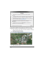
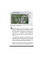
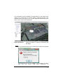
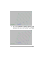
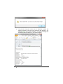
7. The utility will close and the specified information will be imported into IRRICAD. If you have imported elevation data, you may now wish to calculate contours (Tools|Calculate Contours). Notes: The image is rotated because it has been rectified - a rectangle defined by latitude and longitude is not rectangular in UTM. It needs to be rectified to be accurate, especially if you go back to Google Earth from IRRICAD. There is an option in the utility to turn off the rectification, but it has little to recommend it other than 'looking nicer'. An explanation of UTM is located in Help|Help Topics – User Manual – Entering Information into IRRICAD -> Entering a Scale Plan -> Importing a DXF, VCD, DWG, GCD, SHP, MIF, CSV or KML File -> GIS options Section 2.4.1.1 Each spot height is determined at a latitude/longitude point, and is subsequently converted to UTM. As such, they are all spatially independent and don’t require rectification. Note that they come from an interpolation in the Google Earth Plugin and will be subject to further interpolation/smoothing by IRRICAD, so they should not be used as the basis of any rigorous solutions. Always double-check dimensions using known world lengths of existing objects, for example, fence lines. Satellite imagery may overlap photos and cause quoting or installation inaccuracies. Release Notes IRRICAD Pro Version 14 Release Notes Pro V14 5