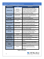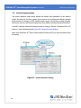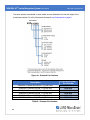
1
LORD USER MANUAL
3DM-GX4-45™
GPS-Aided Inertial Navigation System (GPS/INS)
MicroStrain® Sensing Systems
459 Hurricane Lane
Suite 102
Williston, VT 05495
United States of America
Phone: 802-862-6629
Fax: 802-863-4093
http://www.microstrain.com
[email protected]
[email protected]
Copyright © 2015 LORD Corporation
3DM® , 3DM-DH® , 3DM-DH3™, 3DM-GX1® , 3DM-GX2® , 3DM-GX3® , 3DM-GX4-15™, 3DM-GX4-25™, 3DM-GX4-45™,
3DM-GX4™, 3DM-RQ1™,3DM-GQ4™, AIFP® , Ask Us How™, Bolt-Link® , DEMOD-DC® , DVRT ® , DVRT-Link™, EH-Link® ,
EmbedSense® , ENV-Link™, FAS-A® , G-Link® , G-Link2™, HS-Link® , IEPE-Link™, Inertia-Link® , Little Sensors, Big Ideas.® ,
Live Connect™, LXRS® , MathEngine® , MicroStrain® , MVEH™, MXRS® , Node Commander ® , PVEH™, RHT-Link® , RTDLink™, SensorCloud™, SG-Link® , Shock-Link™, Strain Wizard® , TC-Link® , Torque-Link™, V-Link® , Watt-Link™, Wireless
Simplicity, Hardwired Reliability™, and WSDA® are trademarks of LORD Corporation.
Document 8500-0041 Revision E
Subject to change without notice.
3DM-GX4-45™ Inertial Navigation System User Manual
Table of Contents
1.
System Overview
7
2.
Sensor Overview
8
3.
2.1 Components
9
2.2 Interface and Indicators
10
Basic Setup and Operations
3.1 Software Installation
12
3.2 System Connections
13
3.3 Software Interface
14
3.3.1 Interactive Help Menu
14
3.4 Sensor Communication
15
3.5 GPS Satellite Link
16
3.6 Sensor Settings
17
3.6.1 Saving Configurations
4.
11
18
3.7 Data Monitoring and Recording
19
3.8 Viewing Data
22
Sensor Measurements
23
4.1 Direct Sensor Measurements (IMU Outputs)
24
4.2 Global Positioning System (GPS) Outputs
26
4.3 Computed Outputs (Estimation Filter)
28
4.4 Sensor Reference Frames
31
4.4.1 Geodetic Frame
31
4.4.2 North East Down (NED) Frame
32
4.4.3 Sensor Frame
33
3DM-GX4-45™ Inertial Navigation System User Manual
5.
6.
7.
4.4.4 Platform Frame
34
Performance Optimization
36
5.1 Magnetometer Calibration
36
5.2 Gyroscope Bias
39
5.3 Heading Drift and Compensation
40
5.4 Angular Rate and Acceleration Limits
41
5.5 Bandwidth
41
5.6 Platform Frame Transformation
41
5.7 GPS Parameters
41
5.8 GPS Antenna Offset
42
5.9 Vehicle Dynamics Mode
43
5.10 Estimation Filter Operation
44
5.11 Estimation Filter Convergence
46
5.11.1 Initial Convergence
46
5.11.2 Bias Convergence
46
5.11.3 Output Uncertainty
46
5.12 Vibration Isolation
47
5.13 IMU Sensor Calibration
47
5.14 Temperature Compensation
47
Sensor Installation
48
6.1 Sensor Mounting
48
6.2 GPS Antenna Installation
49
OEM System Integration
50
7.1 Data Communications Protocol (DCP)
7.1.1 Packet Builder
50
51
3DM-GX4-45™ Inertial Navigation System User Manual
7.1.2 Sensor Direct Mode
52
7.1.3 GPS Direct Mode
53
7.2 Sensor Wiring
54
7.3 Alternate GPS Equipment
55
7.3.1 GPS External Receiver
55
7.4 Sampling on Start-up
57
7.5 Connecting to a Datalogger
58
7.6 Using Wireless Adapters
58
8.
Troubleshooting
59
8.1 Troubleshooting Guide
59
8.2 Repair and Calibration
64
8.3 Technical Support
65
9.
Maintenance
10.
66
Parts and Configurations
67
10.1 Standard Configurations
67
10.2 Accessories
69
10.3 Sales Support
70
11.
Specifications
71
12.
Safety Information
73
12.1 Disposal and Recycling
13.
Addendum
13.1 Reference Diagrams
73
74
74
13.1.1 Sensor Dimensions and Origin
74
13.1.2 GPS Antenna Specifications
75
13.1.3 Power Supply Specifications (RS232 kits only)
76
3DM-GX4-45™ Inertial Navigation System User Manual
13.1.4 Communication and Power Cables
77
13.2 Reference Documents
78
13.3 Glossary
79
3DM-GX4-45™ Inertial Navigation System User Manual
1.
System Overview
System Overview
The LORD MicroStrain ® family of industrial and tactical grade inertial sensors provide a wide
range of triaxial orientation measurements and computed navigation solutions. In all models, the
Inertial Measurement Unit (IMU) includes direct measurement of acceleration and angular rate,
and some also offer atmospheric pressure readings. Sensor measurements are processed
through an Extended or Adaptive Kalman Filter (EKF/AKF) to produce highly accurate computed
outputs. The computed outputs vary between models and include: pitch and roll in the 3DM-GX415™ IMU/VRU model, the full attitude solution (pitch, roll, and yaw) in the 3DM-GX4-25™ AHRS
model, and the full PVA (position, velocity and attitude) solution in the 3DM-GX4-45™ and 3DMRQ1-45 ™ GPS/INS, and 3DM-GQ4-45 ™ GNSS/INS models. The Kalman filter provides EKF
technologies to compensate for magnetic and linear acceleration anomalies as applicable to the
model. It also provides sensor bias tracking, auto- zero update options (ZUPT), and user
adjustable sensor noise factors. All sensors are fully temperature compensated and calibrated
over the full operating temperature range.
The use of Micro-Electro-Mechanical System (MEMS) technology allows for small, lightweight
devices. Sensors are integrated into customer systems using serial communication protocols such
as RS422, RS232 and USB. The LORD MicroStrain ® MIP ™ Monitor software can be used for
device configuration, real time measurement monitoring, and data recording. The LORD
MicroStrain ® MIP ™ Data Communications Protocol that is used to communicate with LORD
MicroStrain® inertial sensors is also available for users who want to develop customized software
solutions. Because of the unified set of commands across the sensor family, it is easy to migrate
code from one inertial sensor to another.
Common applications of LORD MicroStrain ® inertial sensor products include vehicle health
monitoring, platform stabilization, down- hole and drilling operations, and inertial navigation
systems such as unmanned air and ground vehicles and personal navigation systems.
7
3DM-GX4-45™ Inertial Navigation System User Manual
2.
Sensor Overview
Sensor Overview
The 3DM-GX4-45™ is a high-performance, miniature, Inertial-Aided GPS Navigation System
(GPS/INS) that combines micro inertial sensors and a high- sensitivity embedded Global
Positioning System (GPS) receiver for use in a wide range of industrial grade applications, such as
unmanned vehicle navigation, robotic control, platform stabilization, motion tracking and analysis,
vehicle health monitoring, and device aiming.
The 3DM-GX4-45 ™ utilizes the strengths of integrated multi-axis gyroscopes, accelerometers,
and magnetometers in combination with GPS, temperature, and pressure readings to provide
highly accurate position, velocity, attitude (including heading), and inertial measurements. Each of
the integrated sensors is especially good at certain tasks, and it is the weighted combination of
their outputs that provides the best estimations for position, velocity, and attitude. All sensor
measurements are temperature compensated and are mathematically aligned to an orthogonal
coordinate system. The combination of sensors, environmental compensation, and dual on-board
processing with an Extended Kalman Filter (EKF) allows the 3DM-GX4-45™ to perform well in a
wide variety of applications that require low noise, drift, gain, and offset errors. Uncertainty
monitoring, scale factor estimation, and bias estimation outputs are available, and settings for
sensor filtering, sensor noise, sensor bias, and more offer many adjustments for specific
application needs.
The 3DM - GX4- 45 ™ communicates through a serial connection and is monitored by a host
computer. A detachable GPS antenna is plugged into the sensor and positioned with unobstructed
line of sight to the sky to obtain satellite links. Sensor measurements and computed outputs can be
viewed and recorded with the LORD MicroStrain ® MIP ™ Monitor software that is provided with
system starter kits and also available as a free download from the LORD MicroStrain® website.
Alternatively, users can write custom software with the LORD MicroStrain ® open source data
communication protocol. The data is time-aligned and available by either polling or continuous
stream.
Figure 1 - 3DM-GX4-45™ Sensor
8
3DM-GX4-45™ Inertial Navigation System User Manual
2.1
Sensor Overview
Components
The 3DM -GX4 -45 ™ can be purchased by itself or in a starter kit that includes everything
needed to begin using it. The starter kits include the 3DM-GX4-45 ™ inertial sensor, a serial
communication cable (either RS232 or USB), a power supply with international plug adapters
(RS232 kits only), an external GPS antenna with a three-meter cable, a non-magnetic GPS
antenna adapter cable, and all software, drivers, and documentation. This manual covers all
items included in the starter kits. For a complete list of available configurations, accessories,
additional system products, and ordering information see Parts and Configurations on page
67see Parts and Configurations on page 67.
Item
A
B
C
D
E
---
Description
3DM-GX4-45™
Inertial Sensor
1
Communications cable (USB or RS232)
1
Power supply and plug adapters (for RS232 only)
1
GPS antenna with attached cable (3m SMA)
1
GPS antenna cable adapter (non-magnetic MMCX-to-SMA)
1
MIP™ Monitor Software Suite
1
User Documentation and Calibration Certificate
1
Table 1 - Starter Kit Components List
9
Quantity
3DM-GX4-45™ Inertial Navigation System User Manual
2.2
Sensor Overview
Interface and Indicators
The 3DM-GX4-45 ™ sensor interfaces include a communications and power input connector
and a GPS antenna port. The sensor is mounted using the mounting and alignment holes as
needed (see Sensor Mounting on page 48).
The indicators on the 3DM - GX4 - 45 ™ include a device status indicator and the device
information label. Table 2 - Indicator Behaviors describes the basic status indicator behavior.
The device information label includes the sensor frame diagram (axis orientation), which will be
critical during device installation (see Sensor Frame on page 33).
Figure 2 - Interface and Indicators
Indicator
Behavior
Device Status
device status
indicator
OFF
rapid flash
steady blink
slow pulse
no power applied
streaming data with no GPS lock
streaming data with GPS lock
idle mode, awaiting commands
Table 2 - Indicator Behaviors
10
3DM-GX4-45™ Inertial Navigation System User Manual
3.
Basic Setup and Operations
Basic Setup and Operations
Do not put the 3DM-GX4 ™ in contact with or in close proximity
to magnets. Magnets may disrupt operation and cause
magnetization of internal components, which can affect
magnetometer performance. If magnetization is suspected,
use a degaussing tool to demagnetize.
To acquire sensor measurements and computed outputs, the 3DM - GX4 - 45 ™ uses a host
computer, a serial communications port, and applicable software. The LORD MicroStrain ®
MIP™ Monitor software is provided with the system and includes all functions needed for sensor
configuration and data acquisition. Users may also utilize the LORD MicroStrain ® MIP ™ Data
Communications Protocol to write custom software applications with expanded or specific feature
sets needed for the application. MIP™ Monitor includes a message building tool that can be used
to streamline this process. For more information see OEM System Integration on page 50.
In this section hardware and software setup is described, including an overview of the
MIP™ Monitor software menus required to configure a sensor and begin data acquisition. This is
intended as a quick start guide and is not a complete demonstration of all system or software
features and capabilities.
Figure 3 - Acquiring Sensor Data with MIP™ Monitor
11
3DM-GX4-45™ Inertial Navigation System User Manual
3.1
Basic Setup and Operations
Software Installation
NOTE
The MIP™ Monitor Software Suite includes hardware drivers required for 3DMGX4™ sensor operation. Sensors will not be recognized without these drivers
installed.
To install the MIP™ Monitor Software Suite on the host computer, complete the following
steps:
1. Launch the software installation menu by inserting the software CD or thumb drive
into the host computer or, by running the Autorun.exe file from the software
directory in Windows® Explorer.
2. In the software installation (Figure 4 - Software Installation Menu) menu select
"Install MIP Monitor Software" and follow the on-screen prompts to completion.
3. If the sensor has internal magnetometers, select "Install MIP Hard and Soft Iron
Calibration Software" and follow the on- screen prompts to completion. This is
used for magnetometer field calibration.
4. Select "Install Inertial Drivers" to install the hardware drivers required for operating
the sensors, and follow the on-screen prompts to completion.
5. Select "Install Inertial Manuals", if desired, and reboot the host computer.
6. Plug the communications adapter into the host computer, and the drivers will
install automatically. Reboot the computer when complete.
Figure 4 - Software Installation Menu
12
3DM-GX4-45™ Inertial Navigation System User Manual
3.2
Basic Setup and Operations
System Connections
Power is applied to the sensor either through a host computer
USB port or an external power supply, such as the one
provided in the RS232 starter kit. Use only power supplies
within the operating range of the sensor, or damage or injury
could result. Once power is applied the sensor is on and active
(see Specifications on page 71).
To acquire sensor data the following components are needed: 3DM - GX4 - 45 ™ sensor,
communication cable, power cable (as applicable for RS232 communications), GPS antenna,
GPS antenna adapter cable, and a host computer with LORD MicroStrain ® MIP ™ Monitor
installed.
Figure 5 - System Connections
13
3DM-GX4-45™ Inertial Navigation System User Manual
3.3
Basic Setup and Operations
Software Interface
The MIP ™ Monitor software includes a main window with system information and menus, a
device settings window ( see Sensor Settings on page 17 ), and several data monitoring
windows (see Data Monitoring and Recording on page 19).
The main window provides an overview of connected devices. Devices are selected by clicking
on them. A device menu is available by right-clicking on the device name and includes the most
used items from the header row menus (Figure 6 - Main Window). The header row menu
includes selections for data sampling, recording, device settings, opening windows, selecting
which open window to view, and advanced features such as selecting the communications
mode. The icon toolbar includes buttons for Help Menu access, device refresh, and data
sampling and recording (see Data Monitoring and Recording on page 19).
Figure 6 - Main Window
3.3.1
Interactive Help Menu
MIP ™ Monitor also includes a mouse- over feature that provides explanations of the
information and settings. This feature is enabled by selecting the question mark icon or Help
button in any window.
Figure 7 - Context Sensitive Help Menu
14
3DM-GX4-45™ Inertial Navigation System User Manual
3.4
Basic Setup and Operations
Sensor Communication
Once power has been applied to the sensor, it is on. The sensor selects the appropriate serial
communication (USB or RS232) on power- up based on which cable is connected. If the
hardware drivers have been installed, communication can be established using the
MIP™ Monitor software interface. GPS lock is not required to establish sensor communication.
1. Verify the sensor device status indicator is on.
2. Open the MIP™ Monitor software.
3. The sensor should appear in the device list automatically when the software is
running. The list includes the device information and communication port assignment
(Figure 8 - Sensor Communication). If the sensor is not automatically discovered, use
the refresh button.
Figure 8 - Sensor Communication
NOTE
If data is not actively being exchanged between the sensor and host computer, the
status message may display Not Connected. This indicates the port status, not the
sensor availability. When commands are sent to the sensor, the software will
automatically connect to it before sending the message.
15
3DM-GX4-45™ Inertial Navigation System User Manual
3.5
Basic Setup and Operations
GPS Satellite Link
NOTE
The GPS antenna requires unobstructed line of sight with the sky in order to achieve
communication with the GPS satellites.
Communication between the GPS receiver and GPS satellites is initiated when the 3DM-GX445 ™ is first powered on. The status indicator on the device will blink differently to show if a
satellite link has been established (see Interface and Indicators on page 10). The receiver will
continuously search for satellites until a link is established. When the link is established the GPS
Monitor window in the MIP ™ Monitor software will display the satellite and link statistics (see
Global Positioning System (GPS) Outputs on page 26).
Communication with the satellites is required for proper sensor operation, although some
measurement outputs will be available without it.
16
3DM-GX4-45™ Inertial Navigation System User Manual
3.6
Basic Setup and Operations
Sensor Settings
Device settings are stored in the sensor memory. Only the configuration options that are
available for the type of sensor being used will be available in the configuration menus.
1. To enter the settings menu, right-click on the sensor name, and select Device Settings:
a. Main menu tabs: The main tabs break up the setting into broad functional groups for the
types of measurement available. For the 3DM-GX4-45™ these include calculated measurements (Estimation Filter), GPS metrics (GPS), and direct inertial sensor measurements (IMU/AHRS).
b. Message Format (first sub-menu tab): Under each main menu tab there are additional
sub-menu tabs, including the Message Format tab. The Message Format tab allows the
user to select the measurement type to be displayed and recorded (b1) and the data rate
(rate at which data is sent to the host computer) in samples/second (b2).
c. Measurement parameters (other sub-menu tabs): Available sub-menu tabs besides
the Message Format tab depend on the selected main menu tab. These tabs include the
configurable settings for each measurement.
d. Scrolling: used to navigate to additional sub-menus
e. Help menu: Enable the context-sensitive help menu for explanations of specific settings
(see Interactive Help Menu on page 14).
Figure 9 - Device Settings Menu
17
3DM-GX4-45™ Inertial Navigation System User Manual
Basic Setup and Operations
NOTE
When selecting sensor and estimation outputs to be recorded, communications
bandwidth considerations should be taken into account, especially when using RS232
communications. Lower baud rates equate to lower communications bandwidth,
which can be consumed quickly by selecting a large number of measurements at high
sample rates. Overrunning the communications bandwidth will result in dropped
communications packets and lost data.
3.6.1
Saving Configurations
Sensor settings are saved temporarily by selecting the OK button in the Device Setup
window after configuration, but they are lost when the device is powered off. To save
current settings in the device memory for the future, use the Save Current Settings feature.
First adjust the sensor settings to the desired values. Next select Settings > Save Current
Settings from the main window (Figure 10 - Save Sensor Settings). The setting will now
remain intact when the sensor is powered off and then on again.
To recall the last saved settings select Settings > Load Startup Settings. To revert the
settings back to the factory defaults, select Settings > Load Default Settings.
Figure 10 - Save Sensor Settings
18
3DM-GX4-45™ Inertial Navigation System User Manual
3.7
Basic Setup and Operations
Data Monitoring and Recording
NOTE
During viewing and recording, only the outputs that are selected in the Message
Format tabs in the Device Setup menu are displayed and recorded ( see Sensor
Settings on page 17).
Throughout the MIP ™ Monitor menus the same icons are used to control data streaming
(sampling) and recording ( Table 3 - Sampling and Recording Controls). These icons can be
found in the MIP ™ Monitor main window icon toolbar and in each data monitoring window. The
same commands are also found in the main window Control menu.
Figure 11 - Main Window Controls
Icon
Command
Run: start data streaming
Stop: end data streaming
Step: sample single set of data
Record: start and stop data recording
Table 3 - Sampling and Recording Controls
There are several data monitoring views available depending on what measurements are
desired for monitoring and recording. Each view corresponds to one of the main categories in
19
3DM-GX4-45™ Inertial Navigation System User Manual
Basic Setup and Operations
the Device Settings window. For example, the 3DM - GX4 - 45 ™ includes Sensor Data
Monitoring for the IMU/AHRS measurements, GPS Monitoring for the GPS metrics, and
EF Monitoring for the Estimation Filter outputs (Figure 12 - Data Streaming). During viewing
and recording only the outputs that are selected in the Message Format tab of the Device
Settings menu are displayed and recorded (see Sensor Settings on page 17).
Data streaming must be started before data can be recorded, however it is not necessary to
view it in a data monitoring window. Data monitoring is used primarily to confirm the system is
operating correctly or to view the outputs in near real time. If sensor setup has already been
confirmed, streaming and recording can be initiated from the main window.
Figure 12 - Data Streaming is an example of Sensor Data Monitoring, which displays the
selected IMU/AHRS measurements. In data monitoring windows, no data will be displayed
until data streaming is started, and no data will be recorded (even if it is being viewed) until data
recording is initiated (armed). In the example below, the y- axis of the graph indicates data
points, the x-axis is the measurement units, and there is a tab for each measurement.
1. Right-click on the device in the main window and select Sensor Data Monitoring.
2. Press the Start Streaming icon to start sampling.
Figure 12 - Data Streaming
20
3DM-GX4-45™ Inertial Navigation System User Manual
Basic Setup and Operations
3. To record data, select the Arm Recording icon at any time.
4. Select the type of data file to generate: Binary or CSV. The CSV file is the most
common and can be viewed and processed by data editors such as Microsoft Excel ®.
NOTE
If the data is recorded in Binary format it will require a translation program that
utilizes the LORD MicroStrain® MIP™ Data Communications Protocol to make
it user-readable.
Figure 13 - Data Recording
5. To end recording press the Arm Recording button again, and select OK in the
confirmation prompt window.
6. Select the Stop Streaming icon to end sampling.
7. Use the red "X" in the upper right of the sensor monitoring window to exit monitoring
mode.
21
3DM-GX4-45™ Inertial Navigation System User Manual
3.8
Basic Setup and Operations
Viewing Data
Acquired data is stored in either Binary (.bin) or Comma Separated Values (.CSV) format,
depending on what was selected at the initiation of data recording. The files can be found in the
directory specified at that time or in the default directory on the host computer desktop.
CSV files can be viewed with Microsoft Excel, Quattro Pro, Open Office, or other CSV editors
and spreadsheet programs. Data recorded in Binary format requires a translation program utilizing the LORD MicroStrain®
MIP™ Data Communications Protocol to make it user-readable.
Figure 14 - Exploring Data
NOTE
Data in the data files is displayed in time sequence. If measurements are set to
different data rates, not all time intervals will include a reading from each output that is
being recorded.
22
3DM-GX4-45™ Inertial Navigation System User Manual
4.
Sensor Measurements
Sensor Measurements
The 3DM-GX4-45 ™ block diagram (Figure 15 - 3DM-GX4-45™ Block Diagram ) describes its
primary hardware components and internal configuration. Integrated Micro-Electro-Mechanical
System (MEMS) sensors within the 3DM - GX4 - 45 ™ are collectively known as the Inertial
Measurement Unit (IMU) and include tri-axial gyroscopes (gyros), tri-axial accelerometers, tri-axial
magnetometers, and a pressure altimeter. This technology provides direct measurements of
acceleration, angular rate, magnetic field, pressure, delta-Theta (change in acceleration), and
delta- v (change in velocity). Temperature and pressure sensors provide environmental
information for measurement compensation and altitude estimations. GPS information can be
read directly and is also used in the computed navigation estimations.
Computed estimations for position, velocity, and attitude (PVA) are available outputs on the 3DMGX4-45 ™ . To achieve these estimations, the MEMS sensors and GPS solution are blended
together in a loosely-coupled Extended Kalman Filter on a dedicated filter processor. Additional
user settings such as measurement filtering, biasing, and tolerance values offer adjustments for
specific applications.
Figure 15 - 3DM-GX4-45™ Block Diagram
23
3DM-GX4-45™ Inertial Navigation System User Manual
4.1
Sensor Measurements
Direct Sensor Measurements (IMU Outputs)
The sensors in an Inertial Navigation System (INS), from which measurements for navigation
and orientation are obtained, are collectively known as the Inertial Measurement Unit (IMU).
These sensors are arranged on the three primary axes (x, y, and z) to sense angular rate,
acceleration, and the local magnetic field . The gyroscopes are used to adjust the current
attitude estimate when an angular rate is sensed. The accelerometers sense gravity as well as
linear acceleration. The magnetometers sense the Earth’s magnetic field along with local
magnetic anomalies. All measurements are temperature-compensated and are mathematically
aligned to an orthogonal coordinate system.
The IMU sensors can be read directly to report stand alone inertial measurements or computed
measurements. Because the sensor system is digital, the analog voltage readings from the
sensors are converted into a digital equivalent value based on the volt-to-bit scale of the internal
analog-to-digital voltage converter. In the MIP™ Monitor software the conversion values are not
configurable, but there are user- settable options for how the measurement is made. These
settings are available at: Settings > Device > IMU (tab). With the Help window open (accessed
with the Help button), mousing over context-sensitive settings provides a detailed explanation
of the setting (Figure 16 - IMU Settings).
Figure 16 - IMU Settings
24
3DM-GX4-45™ Inertial Navigation System User Manual
Sensor Measurements
Table 4 - IMU Measurements lists the IMU measurements available for the 3DM-GX4-45 ™ .
Additional measurement units may be available in MIP ™ Monitor for some outputs, however
they are converted values and do not represent the actual sensor outputs. Only actual output
units are listed.
The Complementary Filter (CF) attitude, and up and north vector outputs are computed
estimations from the LORD MicroStrain® 3DM-GX3® inertial sensor family and are available to
maintain backwards compatibility. For new applications it is recommended that these
estimations be computed with the 3DM-GX4™ EF Outputs algorithms (see Computed Outputs
(Estimation Filter) on page 28).
To view and record IMU outputs, see Basic Setup and Operations on page 11.
Measurement
Units
Acceleration
gravitational force (g)
Magnetic Field
Gauss (G)
Angular Rate
radian/second
Delta Angle (Theta)
radians
Delta Velocity
g*seconds
GPS Correlation Timestamp
weeks, seconds, and
status indicators
Ambient Pressure
millibars
CF Attitude
(Euler RPY)
CF Attitude
(Matrix)
CF Attitude
(Quaternion)
CF North Vector
CF Up Vector
radians
-----
Description
three axis acceleration readings in
engineering units
three axis magnetic field readings in
engineering units
three axis rotational velocity reading from
gyroscope in engineering units
time integral of angular rate with
configurable time period
time integral of acceleration with
configurable time period
time metrics from the GPS receiver for
tracking IMU sensor data
air pressure reading from
pressure sensor
Complementary Filter (CF) Euler angles
representation of orientation
Complementary Filter (CF)
matrix representation of orientation
Complementary Filter (CF)
quaternions representation of orientation
Complementary Filter (CF) north vector
Complementary Filter (CF) up vector
Table 4 - IMU Measurements
25
3DM-GX4-45™ Inertial Navigation System User Manual
4.2
Sensor Measurements
Global Positioning System (GPS) Outputs
The Global Positioning System (GPS) receiver in the 3DM - GX4- 45 ™ uses its own GPS
positioning engine to calculate a position, velocity, and time solution, and it requires a minimum
of four satellites. Accuracy and reliability of the GPS readings are highly dependent on the
quality of the satellite fix, and information is provided to determine an appropriate confidence
level. External aiding systems, such as Wide Area Augmentation System (WAAS) in the US,
help compensate for certain error sources that can affect GPS accuracy. Position of the
antenna is also an important consideration (see GPS Antenna Installation on page 49).
Readings and information are available directly from the GPS receiver. Table 5 - GPS Outputs
describes the available outputs. GPS reporting and recording can be enabled in the
MIP™ Monitor software at: Settings > Device > GPS (Figure 17 - GPS Settings).
To view and record GPS outputs, see Basic Setup and Operations on page 11.
Figure 17 - GPS Settings
26
3DM-GX4-45™ Inertial Navigation System User Manual
Sensor Measurements
Measurement
Units
Position (LLH)
degrees
(latitude, longitude)
meters
(height, accuracy)
Velocity (NED)
meters/second
(velocity, accuracy)
GPS Time
weeks & seconds
Position (ECEF)
meters
Velocity (ECEF)
meters/second
(velocity, accuracy)
Speed
meters/second
(speed, accuracy)
DOP Data
--
UTC Data
time and date
Clock Information
GPS Fix
Information
Space Vehicle
Information (SVI)
seconds
Hardware Status
--
DGPS Information
DGPS Channel
Status
--
position reported by GPS module only,
expressed in latitude, longitude, and height
(LLH) with accuracy estimation. Height is
elevation or altitude relative to average sea
level (MSL reading) or height relative to
WSG-84 Ellipsoid (AE reading).
velocity measurement reported by
GPS module only, with reference to the
North- East-Down coordinate system and
with accuracy estimation
time acquired from the satellites
position reported by GPS module only, with
reference to the Earth Centered, Earth Fixed
(ECEF) Cartesian coordinate system
velocity reported by GPS module only, with
reference to the Earth Centered, Earth Fixed
(ECEF) Cartesian coordinate system
speed along direction of travel in 2D and 3D
space as reported by GPS module only
Dilution of Precision (DOP) ratings for
accuracy of GPS readings
Coordinated Universal Time (UTC) to fractional seconds with leap year seconds
adjustment and confidence indicator. Also
week number, month, date and year.
clock accuracy metrics
information about the type, quantity and quality of the satellite connections
referred to as Satellite Info, includes satellite
number and signal strength
operational status of GPS receiver and
antenna
individual satellite signal strength indicator
--
(future use)
Heading (NED)
-N/A
degrees
Description
heading reported by GPS module only, with
reference to the North, East, Down
coordinate system and with accuracy
estimation
Table 5 - GPS Outputs
27
3DM-GX4-45™ Inertial Navigation System User Manual
4.3
Sensor Measurements
Computed Outputs (Estimation Filter)
The computed outputs are measurements from the 3DM-GX4-45 ™ IMU sensors and GPS
receiver that are blended through an Extended Kalman Filter (EKF) algorithm. The Kalman
Filter produces a better estimation of position, velocity, and attitude (PVA) outputs than can be
achieved by the inertial sensors or the GPS individually. This estimate is output at a higher data
rate than GPS and is not subject to the integration errors inherent in an inertial-only solution.
Refer to Table 6 - Estimation Filter Outputs for a complete list of outputs.
In the MIP ™ Monitor software there are user-settable options for how the estimations are
made. These settings are available at: Settings > Device > EF. With the Help window open
(accessed with the Help button), mousing over context-sensitive settings provides a detailed
explanation of the setting (Figure 18 - Estimation Filter Settings).
Figure 18 - Estimation Filter Settings
All of the estimation filter outputs are available to view and record in MIP ™ Monitor. In addition
to the standard position, velocity, attitude, and time (PVA&T) solution, additional filter outputs,
such as uncertainties, inertial sensor bias and scale factors, filter status, and physical models
(WGS84, WMM, and SAM) are available (Table 6 - Estimation Filter Outputs).
To view and record Estimation outputs, see Basic Setup and Operations on page 11.
28
3DM-GX4-45™ Inertial Navigation System User Manual
Measurement
Units
Filter Status
--
GPS Time
weeks & seconds
Position (LLH)
degrees (position)
meters
(height, uncertainty)
Velocity (NED)
meters/second
(velocity, uncertainty)
Attitude
(Euler RPY)
radians
Attitude
(Matrix)
--
Attitude
(Quaternion)
--
Acceleration
(Linear and
Compensated)
meter/second2
Compensated
Angular Rate
radians/second
Gravity Vector
meter/second2
WSG-84 Local
Gravity Magnitude
meter/second2
Heading Update
radians
29
Sensor Measurements
Description
indicates the current state of the EF, such
as running or initializing
GPS time corresponding to the calculated
filter solution
estimated position based on combined
sensors inputs and EF, expressed in latitude, longitude, and height (LLH) with
uncertainly estimation available
estimated velocity based on combined
sensor inputs and EF, with reference to the
North-East-Down coordinate system and
with uncertainty estimation available
Euler angles representation of
orientation expressed as roll, pitch and yaw
(RPY) with one-sigma uncertainly estimation available
transformation matrix that describes
orientation with reference to the Earth
Centered Earth Fixed (ECEF)
coordinate system
unit quaternions representation of
orientation with one-sigma uncertainly
estimation available
absolute or linear acceleration readings
with reference to either the sensor or
vehicle frame (depending on settings), with
bias and scale readings, and one-sigma
uncertainty estimations also available.
measured angular rate corrected using the
estimated gyroscope scale factor and bias,
with reference to either the sensor or
vehicle frame (depending on settings)
estimated WGS84 gravity vector with
reference to either the sensor or vehicle
frame (depending on settings)
local WGS84 gravity vector magnitude
heading used to update EF, calculated from
the selected heading source
(magnetometer, external, etc.) with
3DM-GX4-45™ Inertial Navigation System User Manual
Measurement
WMM (World Magnetic Model)
Pressure Altitude
SAM
Antenna Offset
Error
Units
Gauss
meters (altitude)
meters (altitude)
pressure (milli-bars)
temperature (°C)
density (kg/m3)
meters
Sensor Measurements
Description
one-sigma uncertainty reading available
WMM local magnitude, inclination and
declination based on GPS coordinates
altitude estimate from barometric pressure
altitude as derived from the U.S. Standard
Atmospheric Model (SAM) using the
sensed barometric pressure and air
temperature
filter-calculated error based on the usersupplied GPS antenna offset
Table 6 - Estimation Filter Outputs
30
3DM-GX4-45™ Inertial Navigation System User Manual
4.4
Sensor Measurements
Sensor Reference Frames
4.4.1
Geodetic Frame
The World Geodetic System is the standard for cartography and navigation. The latest
revision, WGS84, is the reference coordinate system for GPS, and the 3DM- GX4-45 ™
reports position using this coordinate frame. It also calculates the magnitude of the local
gravity vector using the WGS84 reference formulas.
The WGS coordinates are latitude (φ), longitude (λ), and height (h) above the reference
ellipsoid. Latitude ranges from -90 degrees at the South Pole to 90 degrees at the North
Pole. Longitude ranges from -180 to 180 degrees, with 0 degrees being the prime meridian.
The -180/180 degree switchover occurs in the middle of the Pacific Ocean and includes a
section of the International Date Line. The model takes into account the oblateness of the
Earth’s surface.
A point (P) on or above the Earth in the WGS84 coordinate system is notated as: latitude
(φ), longitude (λ), and height above the reference ellipsoid (h).
Figure 19 - World Geodetic System (WGS84) Reference Ellipsoid
31
3DM-GX4-45™ Inertial Navigation System User Manual
4.4.2
Sensor Measurements
North East Down (NED) Frame
The North-East- Down (NED) frame is a local coordinate frame, which is formed by a
tangent plane located at a particular point (current coordinates) on the WGS84 reference
ellipse. The NED frame is constructed with the (true) North vector along the line of
longitude, the East vector along the line of latitude, and the Down vector normal to and
towards the tangent plane (Figure 20 - North East Down Frame). The assumption when
using the NED frame is that the local surface can be reasonably approximated by a flat
plane. For most applications, this assumption is valid and provides a more intuitive reference
frame for expressing velocity and attitude information than a global frame.
The 3DM-GX4-45™ reports velocity in this frame and attitude with respect to this frame.
Figure 20 - North East Down Frame
32
3DM-GX4-45™ Inertial Navigation System User Manual
4.4.3
Sensor Measurements
Sensor Frame
The sensor frame is indicated on the top of the device and is oriented such that the x-axis
vector is parallel with the long side of the sensor and points toward the sensor connector,
the y-axis is 90° to the right of the x-axis, and the z-axis goes through the bottom of the
sensor (outward). These axes were selected so that when the connector on the device is
pointed north and the device is upright and level, the sensor frame will match the NED frame
exactly, giving zero rotation.
The 3DM-GX4-45 ™ reports acceleration, angular rate, delta-Theta, delta-velocity, inertial
sensor biases and corrections, and GPS antenna offset error in this frame when no sensorto-platform frame transformation has been provided (see Platform Frame on page 34).
The orientation of the sensor frame with respect to the local NED frame can be viewed in
the MIP ™ Monitor software at: View > 3D Attitude menu. This window displays the
orientation of the sensor in relationship to north and shows measurement origination for
acceleration and angular rate. The view can be rotated for clicking, holding, and dragging
the image. Options for true north and magnetic north georeferences are available through
the magnetic declination correction setting at: Device Settings > EF settings > Geographic.
Refer to the 3DM-GX4-45™ dimensional diagram for the location of the measurement origin
(see Reference Diagrams on page 74).
Figure 21 - Sensor Frame
33
3DM-GX4-45™ Inertial Navigation System User Manual
4.4.4
Sensor Measurements
Platform Frame
The 3DM-GX4-45™ includes the option to define an orientation transformation and offset
distance from the sensor frame to a user-definable platform frame. This is useful when the
sensor cannot be mounted in the same location or orientation as the desired reference point
on the platform frame. The transformation from sensor to platform frame is defined with
Euler angles and is expressed as a rotation from the sensor frame to the platform frame.
The offset is the location of the origin of the platform reference frame with respect to the
origin of the sensor frame, expressed in the sensor frame.
In the following example (Figure 22 - Platform Frame Transformation) the user has defined
the desired reference point on the platform frame to be located at the front bumper of the
vehicle. In accordance with aircraft co-ordinate systems the platform frame is oriented with
the x-axis pointed in the forward direction of travel, the z-axis pointed down, and the y-axis
pointed towards the passenger side. The sensor has been mounted face down toward the
rear of the vehicle, two meters from vehicle reference location with no offset in the y-axis
and z-axis directions. The proper transformation in this example would be: 180 degrees roll,
0 degrees pitch, and 0 degrees yaw, with an offset of [+2, 0, 0] meters (listed as x,y,z).
Figure 22 - Platform Frame Transformation
34
3DM-GX4-45™ Inertial Navigation System User Manual
Sensor Measurements
In the MIP™ Monitor software the transformation and offset settings are entered at: Settings
> Device > Estimation Filter > Mounting in the Mounting Orientation and Mounting Offset
fields (Figure 23 - Platform Frame Settings).
Figure 23 - Platform Frame Settings
The orientation transformation affects the following EF outputs (see Computed Outputs
(Estimation Filter) on page 28 ): attitude, position, linear and compensated acceleration,
compensated angular rate, and gravity vector. It also affects the following IMU outputs:
acceleration, angular rate, magnetic field vector, delta Theta, and delta velocity.
The offset affects the following EF output: position (LLH).
Transformed acceleration is expressed at the location of the sensor but within the platform
frame. For example, if the sensor is offset from the center of gravity (CG), and the platform is
undergoing a rotation, an acceleration (in addition to any linear acceleration of the CG) will
be sensed in accordance with the following formula: (tangent acceleration) = (angular rate)*
(distance from CG).
35
3DM-GX4-45™ Inertial Navigation System User Manual
5.
Performance Optimization
Performance Optimization
5.1
Magnetometer Calibration
Although the 3DM- GX4- 45 ™ magnetometers are calibrated at the factory to remove any
internal magnetic influences in the device, measurements are still subject to influence from
external magnetic anomalies when the sensor is installed. These anomalies are divided into
two classes: hard iron offsets and soft iron distortions. Hard iron offsets are created by objects
that produce a magnetic field. Soft iron distortions are considered deflections or alterations in
the existing magnetic field. Ideally, these influences are mitigated by installing the sensor away
from magnetic sources, such as coils, magnets, and ferrous metal structures and mounting
hardware. However, often these sources are hard to avoid or hidden.
To mitigate this effect when using the 3DM - GX4 - 45 ™ magnetometer to aid in heading
estimations, a field calibration of the magnetometer after final installation is highly
recommended. This can be accomplished using LORD MicroStrain® MIP™ Hard and Soft Iron
Calibration software. This software is included with the MIP ™ Monitor Software Suite (see
Software Installation on page 12). The following are instructions for field calibrating the
magnetometers:
1. Connect and power-on the sensor as normal, and open the MIP™ Hard and Soft Iron
Calibration software.
2. Enter the Local Magnetic Field information (Figure 24 - Sensor Menu) for the sensor
to account for magnetic influences inherent to the sensor's geographic location on the
Earth. As needed, use the WMM on Web button to access a World Magnetic Model
calculator on the British Geographic Survey website. This site, and similar sites,
generate Local Magnitude F and Local Inclination I values based on latitude and
longitude entries. In the calculator solution, these values will be found in row MF,
column F and row MF, column I, respectively.
Figure 24 - Sensor Menu
36
3DM-GX4-45™ Inertial Navigation System User Manual
Performance Optimization
3. The sensor should automatically appear in the sensor list (Figure 24 - Sensor Menu).
If not, use the Refresh button to query it and then select the sensor.
4. Select the Arm Recording button next to Collect Data (Figure 25 - Collect Calibration
Data). The software will begin taking readings, as indicated by the points counter in
the graphing window. The maximum number of points is 1000, however 100 is
usually adequate. As the readings are taken, rotate the sensor or sensor platform in
all possible directions to get a complete profile of the baseline magnetic influences
throughout the sensor frame. Data points will appear on the graph in red. For mobile
sensor platforms, such as ground vehicles, move the platform as much as possible to
simulate actual use without exposing it to excessive magnetic sources (such as
driving over railroad tracks or near steel pilings). The intention is to get a baseline of
the platform in a neutral environment that still accounts for the platform itself in all
orientations. For stationary platforms the baseline may include significant magnetic
influences that will be present during operation.
Figure 25 - Collect Calibration Data
5. When all possible rotations are completed, select "Stop Streaming" next to Collect
Data, and then select Save Data to save the calibration data points on the host
computer (Figure 25 - Collect Calibration Data).
37
3DM-GX4-45™ Inertial Navigation System User Manual
Performance Optimization
6. Click the Spherical Fit or Ellipsoid Fit button, depending on the application. Spherical
Fit is often best for applications with calibration rotations restricted to a 2D plane: for
example, a ground vehicle or a boat, because it will not likely not be rotated on all
three axis. Ellipsoid Fit is generally a better correction when soft iron effects are
present but only if enough data points can be collected in all quadrants. If the range of
motion is restricted in one dimension, the Spherical Fit may be the best choice. If
there are enough points in all dimensions, the Ellipsoid Fit may be better. Generally, if
the Spherical and Ellipsoid Fits are close in the mean diameter, then the Ellipsoid Fit
will be the best choice.
7. Click Write Spherical Fit or Write Ellipsoid Fit accordingly. This will write the values to
the sensor memory.
8. Cycle power to the sensor when prompted, and then use the Refresh button, if
needed, to re-establish communication with the sensor.
9. Start a calibration verification by clicking the Start Streaming Data button next to
Verify Calibration (Figure 26 - Verify Calibration). Rotate the device in all orientations
in the same way as during calibration. When completed click the Stop Streaming
Data button next to Verify Calibration. The resulting data points should be on or near
the spherical grid. Hold the left mouse button and drag to rotate the image. The
mouse wheel can be used to zoom in and out. If the fit is not close, the sensor may
require re-calibration. If it is close, as shown, calibration and verification is complete.
Figure 26 - Verify Calibration
38
3DM-GX4-45™ Inertial Navigation System User Manual
5.2
Performance Optimization
Gyroscope Bias
Gyroscope biases (offsets) can be zeroed out to set a baseline value for the static home
position and conditions in the application. This should be done after sensor installation.
To set the gyroscope baseline, place the sensor or sensor platform in the desired home
position. Allow 2-3 minutes for the sensor to warm up and for the temperature to stabilize for
the best bias capture. Select Settings > Capture Gyro Bias (Figure 27 - Gyro Bias Capture).
The sensor must remain stationary for about twenty seconds while the outputs are being
measured. A status message will appear when the capture has been completed.
Figure 27 - Gyro Bias Capture
39
3DM-GX4-45™ Inertial Navigation System User Manual
5.3
Performance Optimization
Heading Drift and Compensation
There are four options for the heading reference source: GPS velocity, the magnetometer, an
external reference, or none. If the setting is an external reference, the user has to provide a
heading reference (for example, see GPS External Receiver on page 55). If the setting is none,
the estimated heading will drift when little-or-no changes in velocity are sensed (e.g. when
stationary or traveling in the same direction at a constant velocity). If the setting is the
magnetometer, there will be no drift, but the accuracy will only be as good as the
magnetometer. If using GPS velocity as a heading reference, the sensor (or sensor platform)
has to be moving, or there will be no heading reading. Moving the platform in a dynamic way will
assist in recapturing the heading.
To select between the heading sources in MIP™ Monitor select Settings > Device > Estimation
Filter > EF Options.
Figure 28 - Heading Source Setting
40
3DM-GX4-45™ Inertial Navigation System User Manual
5.4
Performance Optimization
Angular Rate and Acceleration Limits
The 3DM-GX4-45™ angular rate and acceleration range depend on the sensors installed in the
device. Exceeding the specified range for either sensor will result in estimated state errors and
elevated uncertainties until the over-range event is corrected and the filter can resolve the
errors.
5.5
Bandwidth
When selecting sensor and estimation outputs to be recorded, communication bandwidth
considerations should be taken into account, especially when using RS232 serial
communications. Lower baud rates equate to lower communication bandwidth, which can be
consumed quickly by selecting a large number of measurements at high sample rates. Severely
overrunning the communication bandwidth can have adverse effects on the sensor
performance due to excessive processor usage. Most computer RS232 ports are limited to
115,200 baud even though the 3DM-GX4-45™ is capable of running at 921,600 baud.
5.6
Platform Frame Transformation
The transformation from the sensor frame to the platform frame (see Platform Frame on page
34) should be defined to the highest angular accuracy possible. The easiest way to accomplish
this is to co-align the frames. If this is not possible, using a simple transformation (such as 90 or
180 degree rotations on a single axis) is preferred. For complex transformations between the
frames, a calibration should be performed or analysis from a model should be conducted.
5.7
GPS Parameters
The GPS receiver used in the 3DM-GX4-45 ™ has a speed limitation of 500 meters/second in
accordance with the United States International Treaty in Arms Regulation (ITAR) restrictions.
To use the 3DM -GX4 - 45 ™ GPS receiver, the external antenna must be connected and
positioned with unobstructed line of sight to the sky in order to achieve satellite lock. Operating
environment can also effect GPS operation, and the device must be operated within
specifications.
GPS outages should be kept to a minimum. As an outage period progresses, the errors in the
integration of the inertial sensors compound, causing the solution to quickly diverge. Position
errors grow exponentially, and velocity grows linearly with measured acceleration error, and
41
3DM-GX4-45™ Inertial Navigation System User Manual
Performance Optimization
attitude errors will grow linearly with estimated bias error. Monitoring uncertainty metrics during
GPS outage conditions will provide an indication of the estimation accuracy.
5.8
GPS Antenna Offset
GPS antenna offset is the distance of the antenna from the GPS receiver in the 3DM-GX445 ™ . Errors in this offset affects the accuracy of the EKF position, velocity, and attitude
solutions. The MIP ™ Monitor allows entry of the offset in the Settings > Device > Estimation
Filter > Mounting > Antenna Offset (Figure 29 - Antenna Offset).
For the best possible filter solution, the GPS antenna offset should be defined to the highest
degree possible, preferably down to at centimeter. Inaccuracies become non-negligible at 2 to
3 centimeters. The user should strive to minimize this distance, as large offsets (tens of meters
or more) will result in position oscillation due to small orientation inaccuracies. For example, a 1
degree error in attitude with a 10 meter antenna offset would result in a position error of
approximately 0.17 meters. If the offset was only 1 meter, the position error would be 1.7 cm.
Figure 29 - Antenna Offset
42
3DM-GX4-45™ Inertial Navigation System User Manual
5.9
Performance Optimization
Vehicle Dynamics Mode
The vehicle dynamics mode setting adjusts the Kalman filter expectation of the vehicle’s
motion. By doing this, the filter is better able to account for the effects that different dynamic
platforms have on changes in GPS satellite pseudo-ranges. Each platform setting (portable,
automotive, airborne, and airborne-high g-force) have different velocity and altitude limitations.
In the MIP™ Monitor software this setting is found at: Settings > Device > Estimation Filter > EF
Options > Vehicle Dynamics Mode (Figure 30 - Vehicle Dynamics Setting).
Refer to the 3DM-GX4-45™ Data Communications Protocol (DCP) for more information about
this setting.
Figure 30 - Vehicle Dynamics Setting
43
3DM-GX4-45™ Inertial Navigation System User Manual
5.10
Performance Optimization
Estimation Filter Operation
The 3DM-GX4-45 ™ combines the information from a GPS receiver and the IMU sensors to
calculate a navigation solution that incorporates the strengths of the individual systems while
minimizing their weaknesses.
The GPS solution is bounded and typically very good, but it is susceptible to several error
sources. Due to the geometry of the satellite constellation, vertical position accuracy is typically
less than horizontal position accuracy. Additionally, errors from atmospheric and multipath
effects, as well as clock error, further degrade the accuracy of the solution. Arguably the largest
problem with a GPS-only solution for navigation is that a single GPS receiver cannot give users
the orientation of the platform unless the sensor coordinate frame is co- aligned with the
platform velocity vector. For a lot of applications, this assumption is too restrictive. For example,
the pitch of an aircraft typically does not match the angle the velocity vector makes with the
horizon. This occurs because the aircraft’s wings must be at an angle with the oncoming air to
generate lift. Making the assumption that the two values are the same and using the pitch angle
as an input to an autopilot is a mistake. In order to obtain the attitude of the vehicle, something
more is needed.
In a conventional Attitude and Heading Reference System (AHRS) several sources of error
exist when making attitude estimates. First, the algorithm assumes the acceleration vector is
dominated by Earth’s gravity, with only transient linear accelerations. When long- duration
linear accelerations are experienced, such as when an aircraft performs a sustained 2G turn,
the AHRS will report incorrect pitch and roll angles. This error is the direct result of the
assumption that the accelerometers are only sensing Earth’s gravity. A second source of error
occurs when the device attempts to measure the Earth’s magnetic field. This field is very weak
compared to the numerous magnetic anomalies typically found on platforms, or naturally
occurring close to the Earth’s surface. If the magnetic anomalies in the platform remain
constant with respect to the sensor (no translation or rotation between the two) they can be
compensated for by performing a hard iron and/or soft iron calibration of the magnetometers
internal to the 3DM-GX4-45 ™ (see Magnetometer Calibration on page 36). The hard iron
calibration compensates for magnetic effects that cause offsets in the magnetic field (additive
effects). The soft iron calibration compensates for effects that cause a non-uniformity of the
magnetic field which results in an ellipsoidal distortion in the field. Non-constant and external
sources, such as those found when traveling through cities, cannot be compensated and may
cause large errors in the heading estimation. Transient errors can be suppressed when the
magnetometer readings are combined with information from the gyroscopes but only for
periods on the order of a few seconds. Longer duration anomalies will result in heading errors.
44
3DM-GX4-45™ Inertial Navigation System User Manual
Performance Optimization
A third source of error occurs when attempting to navigate between geographic way-points
expressed in latitude and longitude. This error is due to the difference between detecting
magnetic north, which is output by the AHRS sensor, and true north, which is used to define
lines of longitude. If the AHRS is always used in one geographical location, the user can correct
for this difference using a constant offset. If the AHRS is used over a wide range of longitude,
the magnetic declination must be calculated from a magnetic model or obtained from GPS
subsystem which outputs this data. The greatest problem with an AHRS is that it is an attitudeonly device and requires a GPS for position and velocity.
As a first attempt at an improved navigation solution, a user could get position and velocity from
a GPS receiver and attitude from an AHRS. This is an acceptable solution for many navigation
problems, but is susceptible to the errors described above. A more accurate estimation of
position, velocity, and attitude can be found by fusing the data from these two independent
systems using a Kalman filter.
The 3DM-GX4-45 ™ runs a loosely-coupled Extended Kalman Filter. In a loosely-coupled filter,
the inertial sensors in the IMU are used to propagate the state estimation at a high rate (500
Hz); whereas the GPS position and velocity measurements are used to periodically correct the
state (4 Hz.) This form of Kalman filter is called a sensor fusion filter as it combines similar
information from multiple sources in a complementary way. This combination takes into
account the statistical properties of the sensors used, providing a better estimate of the true
state than either system individually. The 3DM-GX4-45™ has a full-state dynamics model. The
state propagation utilizes Newton’s and Euler’s equations of motion with the acceleration and
angular rate treated as control inputs. In addition to the GPS measurement, the IMU
magnetometer is available to correct heading mis-alignments which occur during periods of low
dynamics. The magnetometer corrections can be disabled for applications where large, nonconstant magnetic interference sources exist, which would impair their use (such as when
mounting the 3DM-GX4-45™ on a gimbal close to the frame of a ground vehicle).
The Kalman filter estimates the full states of position, velocity, attitude, and sensor parameters
for a total of 25 states: 3 position, 3 velocity, 4 attitude (quaternion), 3 accel bias, 3 gyro bias, 3
accel scale factor, 3 gyro scale factor, and 3 GPS antenna offset error states. The bias states
are estimated in order to compensate for the time-varying biases inherent in MEMS inertial
sensors, which are the largest error sources for these devices. The bias states are subtracted
from the gyroscope and accelerometer inputs, thus providing more accurate inertial data to the
propagation stage of the filter. This enhances overall accuracy and is especially useful during
GPS outage conditions.
45
3DM-GX4-45™ Inertial Navigation System User Manual
Performance Optimization
The Kalman filter also provides statistical information about the quality of the estimated states
described in a covariance matrix. The diagonal terms of the matrix are the variance of each
state, thus the square root of these values are 1-sigma standard deviations. These values give
the filter’s estimation of how well it knows the individual states, given what it knows about the
statistical properties of the noise sources of the various sensors and also provide feedback to
the user as uncertainty values. The GPS position and velocity noise are not white but are
treated as such in a loosely-coupled filter. This approximation results are not optimal, but the
advantages of this type of filter outweigh that disadvantage.
5.11
Estimation Filter Convergence
5.11.1
Initial Convergence
After a successful initialization, a period of convergence for the Kalman filter states occurs.
Position, velocity, roll angle, and pitch angle typically converge very quickly. Heading,
accelerometer bias, and gyro bias take more time to converge. If the initial attitude estimate
provided to the filter is well outside of the true attitude, the filter may diverge and never
recover. This is most likely to occur for the heading estimate when a poor value is used for
initialization and when the vibration environment is strong. Should this occur, it is
recommended that the filter be reset and new attitude estimate provided. Refer to the 3DMGX4-45™ MIP™ DCP Manual for the various ways of providing an initial attitude estimate
through a user-designed interface.
5.11.2
Bias Convergence
Accurate estimation of the biases can take several minutes to converge, therefore after the
filter is initialized, the free- inertial performance will continue to improve until the bias
estimations settles. The MEMS sensor manufacturers quote bias drift stability numbers
which correspond to the expected drift in bias while the sensor is operating. The filter
attempts to track the changing biases over time, and a user can expect these bias estimates
will be non-constant during a navigation run.
5.11.3
Output Uncertainty
The 3DM-GX4-45 ™ estimation data set includes a filter status field that contains a set of
status flags. These flags pertain to high covariance values for position, velocity, attitude, and
inertial sensor parameters. These flags should be monitored and cross-checked against the
corresponding uncertainty fields when they appear. This can assist in determining how
46
3DM-GX4-45™ Inertial Navigation System User Manual
Performance Optimization
trustworthy the solution generated by the Kalman filter is. When the filter is first initialized, it
is likely that some of these values will be beyond limits, and the flags may be asserted. This
fact should be taken into account when developing automated monitoring systems.
5.12
Vibration Isolation
The 3DM-GX4- 45 ™ should be isolated from strong vibrations a much as possible. Strong,
continuous vibrations appear as unaccounted noise to the estimation filter, degrading its
performance.
5.13
IMU Sensor Calibration
All of the internal sensors in the 3DM - GX4 - 45 ™ are calibrated when the device is
manufactured, and the calibration values are saved in the device memory. With the exception
of the magnetometer field calibration (see Magnetometer Calibration on page 36) recalibration
is not required unless the device has been under conditions that exceed the operating
specifications. For example, if the sensor has been exposed to excessive shock beyond the
rated g-force, performance may be compromised. Indications of internal sensor damage may
be seen as measurement offsets or drift when the sensor is in a neutral motionless position.
5.14
Temperature Compensation
All sensor conversion and calibration formulas include temperature compensation. All
computed outputs and IMU sensor outputs are automatically adjusted for local temperature
(see Direct Sensor Measurements (IMU Outputs) on page 24 ).
47
3DM-GX4-45™ Inertial Navigation System User Manual
6.
Sensor Installation
Sensor Installation
6.1
Sensor Mounting
The 3DM-GX4-45™ sensor housing is rated for indoor use only, unless used inside a protective
enclosure. When using the internal GPS receiver, the GPS antenna connector on the side of
the sensor must be accessible.
The sensor has two mounting tabs with holes for fastening. There are two additional holes
used for precise alignment with 2mm dowel pins. One of the holes is slotted to allow for relaxed
pin positioning accuracy. The sensor can be mounted in any orientation, as required for the
application (see Sensor Reference Frames on page 31). The axes are labeled on the face of
the sensor for reference, and the sensor measurement origin is shown in the sensor
dimensional drawing (see Reference Diagrams on page 74).
Figure 31 - Mounting the Sensor
48
3DM-GX4-45™ Inertial Navigation System User Manual
6.2
Sensor Installation
GPS Antenna Installation
The GPS antenna cable is plugged into the non-magnetic SMA-to- MMCX adapter cable
supplied with the 3DM-GX4-45 ™. The adapter cable is then plugged into the 3DM-GX4-45™
housing (see Interface and Indicators on page 10). The GPS antenna provided with the starter
kit can be mounted installing two M3 screws into the base of the antenna ( Figure 32 GPS Antenna Mounting). Alternate antenna and cables, as well as external GPS receivers,
can be used with the 3DM-GX4-45 ™ when appropriate for the application (see Alternate GPS
Equipment on page 55).
The antenna must be mounted with an unobstructed line of sight to the sky in order to establish
GPS satellite links. This can be accomplished through a window or more optimally by placing
the antenna outdoors. Use the GPS Monitor in the MIP™ Monitor software to observe satellite
link strength during installation to optimize placement (see Global Positioning System (GPS)
Outputs on page 26 ). For the most accurate GPS readings and EF outputs the antenna
position, with reference to the sensor, should be carefully measured and entered as the
Antenna Offset setting (see GPS Antenna Offset on page 42).
When using GPS antennas with magnetic bases, take care
to not bring the antenna in close proximity to the sensor either
in handling or in permanent installation, as it may disrupt the
magnetometers within the 3DM-GX4-45™.
Figure 32 - GPS Antenna Mounting
49
3DM-GX4-45™ Inertial Navigation System User Manual
7.
OEM System Integration
OEM System Integration
The 3DM-GX4 -45 ™ starter kit comes with everything that is needed for sensor configuration,
operation, and data collection. However, many applications will require custom solutions because
of physical or environmental constraints, required sensor output processing, or for integration into
control systems that react to the sensor outputs. For these applications the 3DM-GX4-45 ™ is
available as a stand-alone component with optional interface connectors. The communication
protocol used for configuring and acquiring sensor data and estimations outputs is available for
these applications as well.
7.1
Data Communications Protocol (DCP)
The LORD MicroStrain ® MIP ™ Data Communications Protocol includes all commands
available for controlling and acquiring data from the 3DM-GX4-45 ™, including many that are
not available in the MIP ™ Monitor software. Programming is performed through a standard
serial interface program. The programming interface is comprised of setup and control
commands and a very flexible user-configurable data output format. The commands and data
are divided into four command sets and three data sets corresponding to the internal
architecture of the device. The protocol is packet-based. All commands, replies, and data are
sent and received as fields in a message packet. The packets have a descriptor- type field
based on their contents, so it is easy to identify if a packet contains commands, replies, or data.
The MIP ™ software developers kit (SDK) includes sample code and can be found on the
LORD MicroStrain ® website Support page or by contacting Technical Support (see Technical
Support on page 65).
The LORD MicroStrain ® MIP ™ Data Communications Protocol describes each command
description, message syntax, and message option. It also provides examples, and can also be
found on the LORD MicroStrain® website or through Technical Support.
50
3DM-GX4-45™ Inertial Navigation System User Manual
7.1.1
OEM System Integration
Packet Builder
To expedite program development, a packet builder tool is included in the MIP ™ Monitor
software. The packet builder allows users to send multiple packets to the 3DM-GX4-45 ™
and view the resulting reply data.
Applicable protocol structure and design is described 3DM-GX4-45™ MIP ™ DCP Manual.
The manual can be found with software installation thumb-drive, on the LORD MicroStrain®
website Support page or by contacting Technical Support (see Technical Support on page
65).
To use the packet builder select Advanced > Packet Builder from the MIP ™ Monitor main
window (Figure 33 - Packet Builder). The sensor must be in the Standard communications
mode to use this feature.
Figure 33 - Packet Builder
51
3DM-GX4-45™ Inertial Navigation System User Manual
7.1.2
OEM System Integration
Sensor Direct Mode
The MIP ™ Monitor software can be used to put the sensor in a mode that allows direct
programmatic access to the internal Inertial Measurement Unit (IMU). The IMU has its own
processor and protocol commands and native data outputs from the individual IMU sensors
that may not be available in MIP™ Monitor.
When in Sensor Direct mode the device normal functionality is not available. The protocol
commands used to interface with the IMU are a subset of the standard LORD MicroStrain®
MIP™ Data Communications Protocol and are further described in the LORD MicroStrain®
MIP ™ Data Communications Protocol manual. For additional information contact LORD
MicroStrain® Technical Support (see Technical Support on page 65).
To enter this mode select Advanced > Communications> Sensor Direct from the
MIP ™ Monitor main window. Once in this mode the device status message will indicate
Sensor Direct Mode (Figure 34 - Sensor Direct Mode).
To exit Sensor Direct Mode select the Refresh button in the MIP™ Monitor at any time, or
use Advanced > Communication menu to select the Standard operating mode.
Figure 34 - Sensor Direct Mode
52
3DM-GX4-45™ Inertial Navigation System User Manual
7.1.3
OEM System Integration
GPS Direct Mode
The MIP™ Monitor software can be used to put the sensor in a mode wherein direct access
to the internal GPS receiver is available. In this mode the 3DM - GX4 - 45 ™ normal
functionality is not available, and protocol commands cannot be used. This mode is called
GPS Direct mode and is used to allow communication with the receiver through an external
utility program available from the GPS receiver manufacturer (such as u- blox) or by
contacting LORD MicroStrain ® Technical Support (see Technical Support on page 65).
Also refer to the Using u- blox Software Technical Note for specific instructions ( see
Reference Documents on page 78).
To start communicating with the GPS receiver in GPS Direct mode, select Advanced >
Communication > GPS Direct from the MIP™ Monitor main window. Once in this mode the
device status message will indicate "GPS Direct Mode" (Figure 35 - GPS Direct Mode).
Figure 35 - GPS Direct Mode
53
3DM-GX4-45™ Inertial Navigation System User Manual
7.2
OEM System Integration
Sensor Wiring
Only use power supplies within the operating range of the
sensor, or permanent sensor damage or personal injury could
result. There are two input power pins available, each with
different voltage ranges. Connect only one at a time. Observe
connection polarity.
Sensor power and serial communications cables are available from LORD MicroStrain® and
come with the sensor starter kits. These cables will have the micro-DB9 connector on one end
(to connect to the sensor) and either a standard DB9 on the other end (for RS232
communication) or a USB connector (for USB communications). Alternately, the micro-DB9
can be purchased from LORD MicroStrain® with flying leads or the connector by itself can be
purchased from the manufacturer (Ulti-Mate Connector Inc.). See Parts and Configurations on
page 67 for a list of available options.a standard DB9 on the other end. For the cable diagram
see Reference Diagrams on page 74.
The connector interface includes connections for USB and RS232 communications (only
connect one), two options for sensor input power range (only connect one), and a precision
hardware timing output (PPS output) for synchronizing with external timestamps. The sensor
selects the appropriate serial communication (USB or RS232) on power-up based on which
connection is used.
Figure 36 - Connector Wiring
54
3DM-GX4-45™ Inertial Navigation System User Manual
7.3
OEM System Integration
Alternate GPS Equipment
Other (external) GPS receivers, antennas, and/or cables can be used with the 3DM-GX4-45™.
When using third party antennas the antenna cable length, antenna gain, and antenna power
must be considered. For antennas with internal LNA (Low Noise Amplifiers) the power
requirements should not have a minimum voltage below 3 volts, and the current draw should
not be over 20mA. The longer the cable, the lower the signal strength, and including the
antenna cable offset in GPS outputs is advised (see GPS Antenna Offset on page 42). The loss
of signal strength can only be empirically determined by trying out a particular installation and
monitoring the number of satellite links and quality of data reception from those satellites. This
can be done with the MIP™ Monitor software (see Global Positioning System (GPS) Outputs
on page 26).
When using a different GPS antenna, always use the non-magnetic MMCX-to-SMA adapter
supplied with the 3DM-GX4-45™ unless the magnetometer is not used in the end application.
7.3.1
GPS External Receiver
To use an external GPS receiver, the internal receiver must be disabled, and a serial link
must be established between the receiver and the sensor through the host computer. A
program is then written using the LORD MicroStrain ® MIP ™ Data Communications
Protocol to port the data from the GPS input via the host to the sensor serial port and to
translate the GPS receiver data into the message structure the sensor processor can
interpret. The data cannot be sent any faster than 20 Hz.
To set the GPS receiver to external, open the Device Settings menu in the MIP ™ Monitor
software by right-clicking on the sensor name in the main window (Figure 37 - GPS Source
Select). Select the Estimation Filter tab and then EF Options. Set the GPS Update Source
to External GPS .
Test external GPS messaging using the Advanced > GPS External Input interface. This
command will send a fixed external GPS message to the device and mimic a pulse- persecond clock input (Figure 38 - External GPS Data).
55
3DM-GX4-45™ Inertial Navigation System User Manual
Figure 37 - GPS Source Select
Figure 38 - External GPS Data
56
OEM System Integration
3DM-GX4-45™ Inertial Navigation System User Manual
7.4
OEM System Integration
Sampling on Start-up
The Save Current Settings command can be used to instruct the sensor to start streaming data
as soon as it powered on. This can be useful in sensor integration applications in which
immediate data acquisition is desired, and connection to MIP ™ Monitor for data logging is not
required. This functionality can also be embedded in user-designed applications by using the
corresponding LORD MicroStrain ® MIP ™ Data Communications Protocol command ( see
Data Communications Protocol (DCP) on page 50 for more information).
NOTE
When setting the sensor to begin sampling on start-up, verify that the sensor is
sampling by reading the status indicator on the device ( see Interface and
Indicators on page 10), or by viewing the serial data stream from the host
computer. If communication with MIP ™ Monitor is established, the sampling
will stop to facilitate device configuration.
To save the current sensor configuration, first adjust the sensor settings to the desired values,
and then start streaming. Next select Settings > Save Current Settings from the main window
(Figure 39 - Save Sensor Settings). The setting will remain intact when the sensor is powered
off and then on again.
To recall the last saved settings select Settings > Load Startup Settings.
Figure 39 - Save Sensor Settings
57
3DM-GX4-45™ Inertial Navigation System User Manual
7.5
OEM System Integration
Connecting to a Datalogger
Many inertial applications incorporate dataloggers of all different types to collect and distribute
sensor outputs. For more information and examples refer to the "Using Dataloggers with
Inertial Sensors" Technical Note on the LORD MicroStrain ® website, or contact LORD
MicroStrain® Technical Support (see Technical Support on page 65).
7.6
Using Wireless Adapters
In some applications it can be very useful to set up wireless communications between the
sensor to the host computer. One way this can be accomplished is by connecting the serial
output of the sensor to a serial to wireless converter and then connecting the wireless receiver
to the host computer. For more information and an example refer to the "Using RS232
Bluetooth Adapters" Technical Note on the LORD MicroStrain ® website or contact LORD
MicroStrain® Inertial Sensor ProductsTechnical Support (see Technical Support on page 65).
58
3DM-GX4-45™ Inertial Navigation System User Manual
8.
Troubleshooting
8.1
59
Troubleshooting Guide
Troubleshooting
3DM-GX4-45™ Inertial Navigation System User Manual
Problem
Troubleshooting
Possible cause and recommended solution
1.1 no power is applied
1. POWER
sensor does not power
on
The status indicator on the device will be off. Make sure the
sensor is connected to a power source and the status indicator
illuminates.
1.2 power source is off or miswired
Verify the device power source is connected correctly.
1.3 power supply is the wrong voltage
Using a power supply other than the one provided with the
device, or a supply that is outside of the device operating range,
could result in permanent damage or cause it to not work
properly.
1.4 sensor is in firmware update mode
Firmware update mode is used when updating firmware on the
device. If the firmware updater fails, it is possible that the device
can get stuck in the firmware update mode, and the sensor will
be non- responsive. Contact LORD MicroStrain ® Technical
Support (See Technical Support on page 65).
1.5 sensor is damaged
If all power settings and connections have been verified, and
the sensor is still unresponsive, contact LORD MicroStrain ®
Technical Support (See Technical Support on page 65).
2.1 sensor not found in MIP™ Monitor
2. COMMUNICATION
no communication to
sensor or GPS receiver
In MIP ™ Monitor use the Refresh button to look for the sensor
again. If the sensor is still not found try cycling power to the
sensor and refreshing.
2.2 communication cable not connected or miswired
Check, remove, and reconnect communications and power
cables as applicable. Replace or rewire as needed.
2.3 device drivers not installed
Verify the drivers (included with MIP™ Monitor Software Suite)
are installed on the computer and that the software has had
60
3DM-GX4-45™ Inertial Navigation System User Manual
Problem
Troubleshooting
Possible cause and recommended solution
sufficient time to detect it. See Software Installation on page 12
2.4 serial baud rate setting (not applicable to USB
devices)
The host computer serial port baud rate and the sensor baud
settings must match in order for communication be established.
In MIP ™ Monitor this occurs automatically and the baud rate
can only be changed once initial communication is established.
To change the baud rate in MIP ™ Monitor select Settings >
System and select the desired rate.
NOTE: if the baud rate is set higher than the computer serial
port is capable of reading, communication will be permanently
lost with the device. To recover, it will need to be connected to a
higher speed port, connected via USB cable, or sent to LORD
MicroStrain® for reconfiguration.
2.5 GPS receiver is not communicating
The GPS antenna requires unobstructed line of sight to the sky
in order to link with the GPS satellites. Also verify the GPS
antenna is plugged into the sensor and the cable is intact. Verify
the GPS source setting is set for an internal or external device
as applicable. When using an external receiver, a receiver-toserial translation program that utilizes the LORD MicroStrain®
MIP™ Data Communications Protocol is required to provide the
GPS data to the sensor.
2.6 sensor or cables are damaged
Verify all connections, power, and settings. If available, try
installing an alternate cable or sensor one at a time to see if the
faulty device can be identified. If no conclusion can be
determined, or to send a device in for repair, contact LORD
MicroStrain ® Technical Support ( See Technical Support on
page 65).
3.1 sampling settings are incorrect
3. DATA ACQUISITION
sensor data is missing
or incorrect
61
If unexpected measurements or sampling rates are displayed
or recorded, enter the Device Settings menu and verify the
sampling settings.
3DM-GX4-45™ Inertial Navigation System User Manual
Problem
Troubleshooting
Possible cause and recommended solution
3.2 streaming has not started
If data streaming is occurring the sensor device status indicator
will also be flashing to indicate sampling. In MIP™ Monitor the
device status information field will indicate Streaming. If the
sensor is not streaming data, activate it in the software.
3.3 heading data incorrect
If the magnetometers have not been field-calibrated, erroneous
heading data could result. If the GPS antenna offset has not
been entered, or the GPS receiver or satellite link is not
activated, it could also skew heading information.
3.4 sensor data not recorded
Verify data recording has been activated. In MIP™ Monitor the
device status information field will indicate Recording Data. If
the sensor isn't recording, activate in the software. Verify
specific measurements have been enabled for sampling and
recording.
NOTE:Data is recorded in time sequence. If measurements
are set to different sample rates, not all time intervals will
include a reading from each output that is being recorded.
3.5 sensor data recorded in binary format
When data recording is started the user can choose between
CSV and Binary output formats. If the data is recorded in
Binary format it will require a translation program that utilizes
the LORD MicroStrain ® MIP™ Data Communications Protocol
to make it readable.
3.6 sensor has been magnetized
Contact or close proximity with magnets may disrupt the sensor
operation and cause magnetization of internal components,
which can affect magnetometer performance. If magnetization
is suspected, use a degaussing tool to demagnetize.
3.7 sensor is damaged
With the sensor in a static neutral position data, look for
baseline offset or drift on the IMU sensor outputs. Sensor
62
3DM-GX4-45™ Inertial Navigation System User Manual
Problem
Troubleshooting
Possible cause and recommended solution
damage can occur as a result of excessive g- force other
conditions outside of its operating specifications.
63
3DM-GX4-45™ Inertial Navigation System User Manual
8.2
Troubleshooting
Repair and Calibration
General Instructions
In order to return any LORD MicroStrain ® product, you must contact LORD
MicroStrain ® Sales or Technical Support to obtain a Return Merchandise
Authorization (RMA) number. All returned merchandise must be in the original
packaging, including manuals, accessories, cables, etc. with the RMA number
clearly printed on the outside of the package. Removable batteries should be
removed and packaged in separate protective wrapping. Please include the
LORD MicroStrain® model number and serial number, as well as your name,
organization, shipping address, telephone number, and email. Normal turnaround for RMA items is seven days from receipt of item by LORD
MicroStrain®.
Warranty Repairs
LORD MicroStrain ® warrants its products to be free from defective material
and workmanship for a period of one (1) year from the original date of
purchase. LORD MicroStrain ® will repair or replace, at its discretion, a
defective product if returned to LORD MicroStrain® within the warranty period.
This warranty does not extend to any LORD MicroStrain® products that have
been subject to misuse, alteration, neglect, accident, incorrect wiring, misprogramming, or use in violation of operating instructions furnished by LORD
MicroStrain ® . It also does not extend to any units altered or repaired for
warranty defect by anyone other than LORD MicroStrain®.
Non-Warranty Repairs
All non- warranty repairs/replacements include a minimum charge. If the
repair/replacement charge exceeds the minimum, LORD MicroStrain ® will
contact the customer for approval to proceed beyond the minimum with the
repair/replacement.
64
3DM-GX4-45™ Inertial Navigation System User Manual
8.3
Troubleshooting
Technical Support
There are many resources for product support found on the LORD MicroStrain ® website
including technical notes, FAQs, and product manuals.
http://www.microstrain.com/support_overview.aspx
For further assistance our technical support engineers are available to help with technical and
applications questions.
Technical Support
[email protected]
Phone: 802-862-6629
Fax: 802-863-4093
SKYPE: microstrain.orientation.support
Live Chat is available from the website during business hours:
9:00 AM to 5:00 PM (Eastern Time US & Canada)
65
3DM-GX4-45™ Inertial Navigation System User Manual
9.
Maintenance
Maintenance
There are no user-serviceable parts on the 3DM-GX4-45 ™ . Removing the device cover or
disassembling in any way voids the product warranty.
66
3DM-GX4-45™ Inertial Navigation System User Manual
10.
Parts and Configurations
Parts and Configurations
10.1
Standard Configurations
For the most current product information, custom, and OEM options not listed below, refer to
the LORD MicroStrain® website or contact the LORD MicroStrain® Sales Department.
Table 7 - Model Numbers describes the standard models available at the time this manual was
published. Once a model is selected, the part number is further defined by desired configuration
and interface options. The model determines the first four digits of the product part number; the
options are indicated in the last four digits (Figure 40 - Standard Part Numbers).
Table 7 - Model Numbers
67
3DM-GX4-45™ Inertial Navigation System User Manual
Parts and Configurations
The same options are available in each model, and are indicated in the last four digits of the
product part number. For a list of the starter kit contents, see Components on page 9.
Figure 40 - Standard Part Numbers
Description
LORD MicroStrain®
Part Number
3DM-GX4-15 Starter Kit (RS232, +/-5g, 300°/sec)
3DM-GX4-15 Starter Kit (USB, +/-5g, 300°/sec)
3DM-GX4-25 Starter Kit (RS232, +/-5g, 300°/sec)
3DM-GX4-25 Starter Kit (USB, +/-5g, 300°/sec)
3DM-GX4-45 Starter Kit (RS232, +/-5g, 300°/sec)
3DM-GX4-45 Starter Kit (USB, +/-5g, 300°/sec)
6233-4221
6233-4241
6234-4221
6234-4241
6236-4221
6236-4241
Table 8 - Example Part Numbers
68
3DM-GX4-45™ Inertial Navigation System User Manual
10.2
Parts and Configurations
Accessories
The following parts are available for use with the 3DM-GX4™, and some are included in sensor
starter kits (see Components on page 9). For the most current product information refer to the
LORD MicroStrain® website or contact the Sales Department. See Sales Support on page 70.
Description
LORD MicroStrain®
Part Number
RS232 communications cable
USB communications cable
Power supply (RS232 systems only)
Power supply country plug adapter kit (RS232 systems only)
GPS patch antenna with 3m cable, SMA connector
Antenna cable adapter MMCX to SMA
MIP™ Monitor Software Suite flash drive
Sensor mating connector (micro-DB9) with flying leads
4005-0037
9022-0019
9011-0009
9011-0022
9010-0100
9022-0032
8200-0020
6224-0100
Table 9 - Sensor Accessories
Description
Manufacturer
part number
“A” Series or “P” Series 9-pin male Micro-D connector
Ulti-Mate PR09N05
Table 10 - Sensor Mating Connector
69
3DM-GX4-45™ Inertial Navigation System User Manual
10.3
Parts and Configurations
Sales Support
Products can be ordered directly from the LORD MicroStrain ® website by navigating to the
product page and using the Buy feature. http://www.microstrain.com/inertial
For further assistance, our sales team is available to help with product selection, ordering
options, and questions.
Sales Support
[email protected]
Phone: 802-862-6629
Fax: 802-863-4093
9:00 AM to 5:00 PM (Eastern Time US & Canada)
70
3DM-GX4-45™ Inertial Navigation System User Manual
11.
Specifications
Specifications
General
Triaxial accelerometer, triaxial gyroscope, triaxial
magnetometer, temperature sensors, pressure altimeter, and
GPS receiver
Integrated sensors
Inertial Measurement Unit (IMU) outputs: acceleration,
angular rate, magnetic field , ambient pressure, deltaTheta,
deltaVelocity
Computed outputs:
Extended Kalman Filter (EKF): filter status, GPS
timestamp, LLH position, NED velocity, attitude estimates (in
Euler angles, quaternion, orientation matrix), linear and
compensated acceleration, bias compensated angular rate,
pressure altitude, gyroscope and accelerometer bias, scale
factors and uncertainties, gravity and magnetic models, and
more. Complementary Filter (CF): attitude estimates (in
Euler angles, quaternion, orientation matrix), stabilized north
and gravity vectors, GPS correlation timestamp
Data outputs
Global Positioning System outputs (GPS): LLH position,
ECEF position and velocity, NED velocity, UTC time, GPS
time, SV. GPS protocol access mode available.
Inertial Measurement Unit (IMU) Sensor Outputs
Accelerometer
Gyroscope
Magnetometer
Measurement range
±5 g (standard)
±16 g (option)
300°/sec
(standard)
±75, ±150, ±900
°/sec (options)
±2.5
Gauss
Non-linearity
±0.03 % fs
±0.03 % fs
±0.4 % fs
Resolution
<0.1 mg
<0.008°/sec
--
Bias instability
±0.04 mg
10°/hr
--
Initial bias error
±0.002 g
±0.05°/sec
±0.003 Gauss
Scale factor stability
±0.05 %
±0.05 %
±0.1 %
Noise density
100 µg/√Hz
0.005°/sec/√Hz
100 µGauss/√Hz
Alignment error
±0.05°
±0.05°
±0.05°
Adjustable bandwidth
225 Hz (max)
250 Hz (max)
-
Offset error over
temperature
0.06% (typ)
0.05% (typ)
--
Gain error over temperature
0.05% (typ)
0.05% (typ)
--
Scale factor non-linearity
(@ 25° C)
0.02% (typ)
0.06% (max)
0.02% (typ)
0.06% (max)
±0.0015 Gauss
Vibration induced noise
--
0.072°/s RMS/g
RMS
--
Vibration rectification error (VRE)
--
0.001°/s/g2
RMS
--
IMU filtering
4 stage filtering: analog bandwidth filter to digital sigma-delta
wide band anti-aliasing filter to (user adjustable) digital
averaging filter sampled at 4 kHz and scaled into physical
units; coning and sculling integrals computed at 1 kHz
Sampling rate
4 kHz
IMU data output rate
1 Hz to 500 Hz
Pressure Altimeter
71
Range
-1800 m to 10,000 m
Resolution
< 0.1 m
Noise density
0.01 hPa RMS
Sampling rate
10 Hz
4 kHz
50 Hz
3DM-GX4-45™ Inertial Navigation System User Manual
Computed Outputs
Position accuracy
±2.5 m RMS horizontal, ± 5 m RMS vertical (typ)
Velocity accuracy
±0.1 m/s RMS (typ)
Attitude accuracy
EKF outputs: ±0.25° RMS roll & pitch, ±0.8° RMS heading (typ)
CF outputs: ±0.5° roll, pitch, and heading (static, typ), ±2.0°
roll, pitch, and heading (dynamic, typ)
Attitude heading range
360° about all axes
Attitude resolution
< 0.01°
Attitude repeatability
0.3° (typ)
Calculation update rate
500 Hz
Computed data output
rate
EKF outputs: 1 Hz to 500 Hz
CF outputs: 1 Hz to 1000 Hz
Global Positioning System (GPS) Outputs
Receiver type
50-channel u-Blox 6 engine GPS, L1 frequency, C/A code
SBAS: WAAS, EGNOS, MSAS
GPS data output rate
1 Hz to 4 Hz
Time-to-first-fix
Cold start: 27 sec, aided start: 4sec,
hot start: 1 sec
Sensitivity
Tracking: -159 dBm, cold start: -147 dBm,
hot start: -156 dBm
Velocity accuracy
0.1 m/sec
Heading accuracy
0.5°
Horizontal position
accuracy
GPS: 2.5 m CEP
SBAS: 2.0 m CEP
Time pulse signal
accuracy
30 nsec RMS
< 60 nsec 99%
Acceleration limit
≤ 4g
Altitude limit
No limit
Velocity limit
500 m/sec (972 knots)
Communication
USB 2.0 (full speed)
RS232 (9,600 bps to 921,600 bps, default 115,200)
Power source
+ 3.2 to + 36 V dc
Power consumption
170 mA (typ), 200 mA (max) - Vpri = 3.2 to 5.5 V dc
750 mW (typ), 900 mW (max) - Vaux = 5.2 to 36 V dc
Operating temperature
-40 °C to +85 °C
Mechanical shock limit
500 g (calibration unaffected)
1000 g (bias may change)
5000 g (survivability)
MTBF
180,000 hours (Telcordia method I, GL/35C)
67,000 hours (Telcordia method I, GM/35C)
Dimensions
44.2 mm x 24.0 mm x 11.3 mm (excluding mounting tabs), 36.6
mm (width across tabs)
Weight
20 grams
Regulatory compliance
ROHS, CE
Connectors
Data/power output: micro-DB9
GPS antenna: MMCX type
Software
MIP™ Monitor, MIP™ Hard and Soft Iron Calibration, Windows
XP/Vista/7/8 compatible
Compatibility
Protocol compatibility with 3DM-GX3® and 3DM-RQ1-45™
sensor families,
Software development kit
(SDK)
MIP™ data communications protocol with sample code
available (OS and computing platform independent)
Operating Parameters
Physical Specifications
Integration
72
Specifications
3DM-GX4-45™ Inertial Navigation System User Manual
12.
Safety Information
Safety Information
This section provides a summary of general safety precautions that must be understood and
applied during operation and maintenance of components in the LORD MicroStrain ® Inertial
Sensor Products. Throughout the manual, ANSI Z535 standard safety symbols are used to
indicate a process or component that requires cautionary measures.
Situations in which potentially hazardous conditions exist
that could result in death or serious injury of workers and/or
the general public if not avoided.
Situations where a non- immediate or potential hazard
presents a lesser threat of injury that could result in minor or
moderate injury to workers and/or the general public.
Situations where a non- immediate or potential hazard
presents a risk to damage of property and equipment. May
be used to indicate important operational conditions.
12.1
Disposal and Recycling
The 3DM-GX4™ contains internal printed circuit boards
and electronic components. These items are known to
contain toxic chemicals and heavy metals that are
harmful to humans health and the environment. Disposal
is subject to federal and local laws. Do not discard the
device in the trash. Follow proper electronic waste
disposal protocol, as dictated by federal and local
authorities. Some states also have programs for
extracting reusable parts for recycling.
73
3DM-GX4-45™ Inertial Navigation System User Manual
13.
Addendum
Addendum
13.1
Reference Diagrams
The diagrams in this section are to intended to aid in product installation and troubleshooting.
For more information contact LORD MicroStrain ® Technical Support (see Technical Support
on page 65).
13.1.1
Sensor Dimensions and Origin
This diagram describes the sensor physical specification including the measurement point of
origin.
Figure 41 - 3DM-GX4™ Sensor Origin
74
3DM-GX4-45™ Inertial Navigation System User Manual
13.1.2
GPS Antenna Specifications
These specifications describe the GPS antenna included in the 3DM-GX4™ starter kit.
Physical Specifications
Construction
polycarbonate radome enclosure with die cast shell
Dimensions
58.5 mm x 48 mm x 15 mm
Weight
63 g (without cable and connector)
Standard mounting
screw mount with M3 tapped holes in base
Cable
3 m RG174/U (standard)
Cable pulling strength
6 Kg @ 5 sec
Connector
SMA straight 180 male
Overall Performance
Center Frequency
1575.42 MHz
Gain
30 dB minimum
Noise figure
2.0 maximum
VSWR
2.0 maximum
Output impedance
50 ohm
Operating temperature
-40 °C to ~+85 °C
Storage temperature
-50 °C to ~+90 °C
Relative humidity
95% non-condensing
Polarization
RHCP (Right Hand Circular Polarization)
Absolute gain at zenith
+5 dBi typical
Gain at 10° elevation
-1 dBi typical
Antenna Element
Axial ratio
3 dB maximum
Low Noise Amplifier
75
Gain
30 dB typical
Bandwidth
2 MHz minimum
Noise figure
1.3 maximum
Supply voltage
2.5 to 5.5 V dc
Current consumption
10.3 mA ± 1 mA @ 2.2 to ~2.9 V dc
11.5 mA ± 1 mA @ 5 V dc
Addendum
3DM-GX4-45™ Inertial Navigation System User Manual
13.1.3
Addendum
Power Supply Specifications (RS232 kits only)
The power supply is only required for the RS232 devices. These specifications describe the
power supply included in the 3DM-GX4™ starter kit.
Operating Parameters
AC input voltage rating
100 to 240 V ac
AC input voltage range
90 to 264 V ac
AC input frequency range
47 to 63 Hz
AC input current
0.25 A (RMS) maximum @ 120 V ac
0.125 A (RMS) maximum @ 240 V ac
Leakage current
0.25 mA maximum @ 254 V ac
Inrush current
(cold start @ 25 °C)
< 30 A for 120V ac @ maximum load
< 60 A for 240 V ac @ maximum load
Input power saving
(at no load)
0.3 W maximum
DC voltage rating
9 V dc
DC load capacity
0.56 A maximum
Ripple
90 mV peak to peak maximum
Regulation
± 5 % line and load
Efficiency
≥ 72.3 % average
Hold-up time
10 mS @ 120 V ac and maximum load
Circuit protection
> 120 %, auto restart
Over-voltage protection
> 120 %, zener clamp
Safety approvals
cUL/UL, TUV, SAA, CE, C-Tick, GS, EISA, N136
Environmental Parameters
Operating temperature
0 °C to +40 °C
Storage temperature
-25 °C to +85 °C
Humidity
10 to 90 %
Emissions
FCC Class B, EN55022 Class B
Dielectric withstanding (hipot) test
primary to secondary: 3000 V ac
Physical Specifications
76
Dimensions
71.7 mm x 45 mm x 28.9 mm
Weight
120 g
DC output connector
2.1 mm x 5.5 mm center positive standard
Mating connector
Kycon KLD-0202-A or equivalent
3DM-GX4-45™ Inertial Navigation System User Manual
13.1.4
Addendum
Communication and Power Cables
These diagrams describe the cables included in the 3DM-GX4 ™ starter kits. Only one is
included in each kit, depending on the type of kit ordered.
Figure 42 - Communications and power cable (RS232 Kits, PN: 4005-0037)
Figure 43 - Communications cable (USB Kits, PN: 9022-0019)
77
3DM-GX4-45™ Inertial Navigation System User Manual
Addendum
Figure 44 - Connecter interface cable (sold separately, PN: 6224-0100)
13.2
Reference Documents
Many references are available on the LORD MicroStrain ® website including product user
manuals, technical notes, and quick start guides. These documents are continuously updated
and may provide more accurate information than printed or file copies. Document
Where to find it
3DM-GX4-45™ Software Developers Kit
http://www.microstrain.com/softwaredevelopment-kits-sdks
http://www.microstrain.com/support/docs
http://www.microstrain.com/support/docs
http://www.microstrain.com/applications
http://www.microstrain.com/lordmicrostrain-inertial-sensors-all-products
http://www.nist.gov/calibrations/
http://www.astm.org/Standard/standardsand-publications.html
3DM-GX4-45™ MIP™ DCP Manual
Product Technical Notes
Product Application Notes
Product Datasheets
NIST Calibration Procedures
ASTM Testing Procedures
Table 11 - Document Resources
78
3DM-GX4-45™ Inertial Navigation System User Manual
13.3
Addendum
Glossary
A
A/D Value
The digital representation of analog voltages in an analog-to-digital (A/D) conversion. The
accuracy of the conversion is dependent on the resolution of the system electronics. Higher resolution produces a more accurate conversion.
Acceleration
In physics,acceleration is the change in the rate of speed (velocity) of an object over time.
Accelerometer
A sensor used to detect and measure magnitute and direction of an acceleration force (g-force)
in reference to its sensing frame. For example, at rest perpendicular to the Earth's surface an
accelerometer will measure 9.8 meters/second squared as a result of gravity. If the device is
tilted the acceleration force will change slightly, indicating tilt of the device. When the accelerometer is moving it will measure the dynamic force (including gravity).
Adaptive Kalman Filter (AKF)
A type of Extended Kalman Filter (EKF) that contains an optimization algorithm that adapts to
dynamic conditions with a high dependency on adaptive technology. Adaptive technology
refers to the ability of a filter to selectively trust a given measurement more or less based on a
trust threshold when compared to another measurement that is used as a reference. Sensors
that have estimation filters that rely on adaptive control elements to improve their estimations
are refered to as an AKF.
AHRS (Attitude and Heading Reference System)
A navigation device consisting of sensors on the three primary axes used to measure vehicle direction and orientation in space. The sensor measurements are typically processed by an
onboard algorthim, such as an Estimation Filter, to produce a standardized output of attitude
and heading.
Algorithm
In math and science, an algorithm is a step-by-step process used for calculations.
Altitude
the distance an object is above the sea level
Angular rate
The rate of speed of which an object is rotating. Also know as angular frequency, angular
speed, or radial frequency. It is typically measured in radians/second.
79
3DM-GX4-45™ Inertial Navigation System User Manual
Addendum
API (Applications Programming Interface)
A library and/or template for a computer program that specifies how components will work
together to form a user application: for example, how hardware will be accessed and what data
structures and variables will be used.
ASTM (Association of Standards and Testing)
a nationally accepted organization for the testing and calibration of technological devices
Attitude
the orientaion of an object in space with reference to a defined frame, such as the North-EastDown (NED) frame
Azimuth
A horizontal arc measured between a fixed point (such as true north) and the vertical circle
passing through the center of an object
B
Bias
A non-zero output signal of a sensor when no load is applied to it, typically due to sensor imperfections. It is also called offset.
C
Calibration
to standardize a measurement by determining the deviation standard and applying a correction, or calibration, factor
Complementary Filter (CF)
A term commonly used for an algorithm that combines the readings from multiple sensors to
produce a solution. These filters typically contain simple filtering elements to smooth out the
effects of sensor over-ranging or anomalies in the magnetic field.
Configuration
A general term applied to the sensor indicating how it is set up for data acquisition. It includes
settings such as sampling rate, active measurements, measurement settings, offsets, biases,
and calibration values
Convergance
when mathematical computations approach a limit or a solution that is stable and optimal.
80
3DM-GX4-45™ Inertial Navigation System User Manual
Addendum
D
Data Acquisition
the process of collecting data from sensors and other devices
Data Logging
the process of saving acquired data to the system memory, either locally on the device, or
remotely on the host computer
Data rate
the rate at which sampled data is transmitted to the host
Delta-Theta
the time integral of angular rate expressed with refernce to the device local coordinate system,
in units of radians
Delta-velocity
the time integral of velocity expressed with refernce to the device local coordinate system, in
units of g*second where g is the standard gravitational constant
E
ECEF (Earth Centered Earth Fixed)
a reference frame that is fixed to the earth at the center of the earth and turning about earth's
axis in the same way as the earth
Estimation Filter
A mathematical algorithm that produces a statistically optimum solution using measurements
and references from multiple sources. Best known estimation filters are the Kalman Filter,
Adaptive Kalman Filter, and Extended Kalman Filter.
Euler angles
Euler angles are three angles use to describe the orientation of an object in space such as the
x, y and z or pitch; roll; and yaw. Euler angles can also represent a sequence of three elemental
rotations around the axes of a coordinate system.
Extended Kalman Filter (EKF)
Used generically to describe any estimation filter based on the Kalman Filter model that can
handle non-linear elements. Almost all inertial estimation filters are fundamentally EKFs.
G
GNSS (Global Navigation Statellite System)
a global network of space based statellites (GPS, GLONASS, BeiDou, Galileo, and others)
81
3DM-GX4-45™ Inertial Navigation System User Manual
Addendum
used to triangulate position co-ordinates and provide time information for navigational purposes
GPS (Global Positioning System)
a U.S. based network of space based statellites used to triangulate position co-ordinates and
provide time information for navigational purposes
Gyroscope
a device used to sense angular movements such as rotation
H
Heading
an object's direction of travel with reference to a co-ordinate frame, such as lattitude and longitude
Host (computer)
The host computer is the computer that orchestrates command and control of attached devices
or networks.
I
IMU
Inertial Measurement System
Inclinometer
device used to measure tilt, or tilt and roll
Inertial
pertaining to systems that have inertia or are used to measure changes in inertia as in angular
or linear accelerations
INS (Inertial Navigation System)
systems that use inertial measurements exclusively to determine position, velocity, and attitude,
given an initial reference
K
Kalman Filter
a linear quadratic estimation algorithm that processes sensor data or other input data over time,
factoring in underlying noise profiles by linearizing the current mean and covariance to produces an estimate of a system’s current state that is statistically more precise than what a single
measurement could produce
82
3DM-GX4-45™ Inertial Navigation System User Manual
Addendum
L
LOS (Line of Sight)
Describes the ideal condition between transmitting and receiving devices in a wireless network. As stated, it means they are in view of each other with no obstructions.
M
Magnetometer
A type of sensor that measures the strength and direction of the local magnetic field with
refernce to the sensor frame. The magnetic field measured will be a combination of the earth's
magnetic field and any magnetic field created by nearby objects.
MEMS (Micro-Electro-Mechanical System)
The technology of miniaturized devices typically made using micro fabrication techniques such
as nanotechnology. The devices range in size from one micron to several millimeters and may
include very complex electromechanical parts.
N
NED (North-East-Down)
A geographic reference system
O
OEM
acronym for Original Equipment Manufacturer
Offset
A non-zero output signal of a sensor when no load is applied to it, typically due to sensor imperfections. Also called bias.
Orientation
The orientaion of an object in space with reference to a defined frame. Also called attitude.
P
Pitch
In navigation pitch is what occurs when vertical force is applied at a distance forward or aft from
the center of gravity of the platform, causing it to move up or down with respect to the sensor or
platform frame origin.
83
3DM-GX4-45™ Inertial Navigation System User Manual
Addendum
Position
The spatial location of an object
PVA
acronym for Position, Velocity, Attitude
Q
Quaternion
Mathematical notation for representing orientation and rotation of objects in three dimensions
with respect to the fixed earth coordinate quaternion. Quaternions convert the axis–angle representation of the object into four numbers and to apply the corresponding rotation to a position
vector representing a point relative to the origin.
R
Resolution
In digital systems, the resolution is the number of bits or values available to represent analog
voltages or information. For example, a 12-bit system has 4096 bits of resolution and a 16-bit
system has 65536 bits.
RMS
acronym for Root Mean Squared
Roll
In navigation roll is what occurs when a horizontal force is applied at a distance right or left from
the center of gravity of the platform, causing it to move side to side with respect to the sensor or
platform frame origin.
RPY
acronym for Roll, Pitch, Yaw
RS232
a serial data communications protocol
RS422
a serial data communications protocol
S
Sampling
the process of taking measurements from a sensor or device
84
3DM-GX4-45™ Inertial Navigation System User Manual
Addendum
Sampling rate
rate at which the sensors are sampled
Sampling Rate
the frequency of sampling
Sensor
a device that physically or chemically reacts to environmental forces and conditions and produces a predictable electrical signal as a result
Sigma
In statistics, sigma is the standard deviation from the mean of a data set.
Space Vehicle Information
refers to GPS satellites
Streaming
typically when a device is sending data at a specified data rate continuously without requiring a
prompt from the host
U
USB (Universal Serial Bus)
A serial data communications protocol
UTC (Coordinated Universal Time)
The primary time standard for world clocks and time. It is similar to Greenwich Mean Time
(GMT).
V
Vector
a measurement with direction and magnitude with refernce from one point in space to another
Velocity
The rate of change of position with respect to time. Also called speed.
W
WAAS (Wide Area Augmentation System)
An air navigation aid developed to allow aircraft to rely on GPS for all phases of flight, including
precision approaches to any airport.
85
3DM-GX4-45™ Inertial Navigation System User Manual
Addendum
WGS (World Geodetic System)
a protocol for geo-referencing such as WGS-84
Y
Yaw
In navigation yaw is what occurs when rotational force is applied at a distance forward or aft
from the center of gravity of the platform, causing it to move around the center axis of a sensor
or platform frame origin.
86