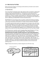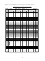
1
Manual of Instructions
End of Spring Trap
Netting (ESTN)
Manual of Instructions
End of Spring Trap Netting (ESTN)
2004
Audie Skinner and Helen Ball
Fisheries Section
Ontario Ministry of Natural Resources
P.O. Box 7000
300 Water Street
Peterborough, ON K9J 8M5
Cette publication spécialisée n’est disponsible qu’en anglais.
© 2004, Queen’s Printer for Ontario
Printed in Ontario. Canada
Copies of this publication are available from:
Ontario Ministry of Natural Resources
Fish and Wildlife Branch
P.O. Box 7000
300 Water Street
Peterborough, ON K9J 8M5
TABLE OF CONTENTS
1.0 INTRODUCTION .......................................................................................... 1
2.0 SURVEY DESIGN AND METHODS ........................................................ 2
2.1 Sampling Methods ..................................................................................................2
2.2 Sample Size ............................................................................................................3
3.0 GEAR DESCRIPTION ................................................................................. 3
3.1 How Fish are Captured..........................................................................................4
3.2 The Standard ESTN Trap Net ...............................................................................5
4.0 PRE- FIELD ACTIVITIES ........................................................................... 8
4.1 Site Selection.........................................................................................................8
4.2 Preparation of Field Forms ....................................................................................9
4.3 Preparing a Public Information Notice ...................................................................9
4.4 Preparation of Equipment....................................................................................11
4.5 Rigging the Trap Net ...........................................................................................12
4.6 Training................................................................................................................13
5.0 FIELD PROCEDURES .............................................................................. 13
5.1 Site Selection.......................................................................................................13
5.2 Setting the Net.....................................................................................................14
5.3 Information to Record at Set................................................................................16
5.4 Lifting the Net ......................................................................................................24
5.5 Information to Record at Lift ................................................................................25
5.6 Fish Sampling......................................................................................................29
5.7 Recording Fish Data............................................................................................31
5.7.1 ESTN Length Class Tally Forms ............................................................31
5.7.2 ESTN Fish Sampling Form ....................................................................34
5.7.3 ESTN Effort/Catch Form ........................................................................37
5.8 Moving or Removing the Net ...............................................................................40
6.0 POST- FIELD ACTIVITIES ..............................................................................41
6.1 Controlling the Spread of Invasive Species.........................................................41
6.2 Net Storage .........................................................................................................42
6.3 Gear Log..............................................................................................................42
7.0 DATA MANAGEMENT .............................................................................. 43
8.0 PROJECT ASSISTANCE ......................................................................... 43
Acknowledgements ......................................................................................... 43
References.......................................................................................................... 44
Appendix A: Master List of Species Codes and Common Names of Ontario Fish.......45
Appendix B: ESTN Forms ............................................................................................52
1.0 INTRODUCTION
End of Spring Trap Netting (ESTN) is a standard live release trap netting program designed to
estimate the relative abundance of a fish stock, and provide other biological measures to
assess the status of walleye populations in Ontario.
Fall Walleye Index Netting (FWIN) (Morgan, 2002) is the preferred standard netting procedure
for monitoring Ontario walleye populations. FWIN should be used where mortality is not an
issue as it samples a greater diversity of habitat (i.e. not just shoreline/littoral zone) and
provides better information on the forage fish community, especially yellow perch. FWIN also
allows for better age determination through the use of otoliths and can provide information on
fecundity and maturity. ESTN provides a standard procedure to accommodate managers of
fisheries where walleye mortality associated with gill netting is not acceptable. Fish attribute
data such as age structure, growth, condition and recruitment can also be collected through
ESTN, but since it is a live release method, data on maturity and fecundity are not collected.
ESTN is an adaptation of the Nearshore Community Index Netting (NSCIN) program (Stirling,
1999) that was designed to provide trend through time information on nearshore fish
communities. The ESTN method was proposed because the population density of walleye is
better reflected when trap netting is completed in late spring and early summer, rather than
during the NSCIN period of August and early fall (Sampling Standards and Diagnostics Working
Group, Percid Synthesis, 1998). A properly conducted ESTN should, at a minimum, provide
fisheries managers with abundance and biological attribute data that can be used to make
relative comparisons to provincial benchmark values from other lakes in Ontario. Preliminary
analysis of data from lakes studied by Quetico-Mille Lacs Fisheries Assessment Unit and
Kawartha Lakes Fisheries Assessment Unit indicate that there is a strong relationship between
ESTN catches and relative abundance of walleye greater than 200 mm. Benchmarks are
currently being refined and will be documented in a future Fisheries Assessment Unit report.
A successful index netting program requires stringent standardization of gear and methods in
order to reduce sampling variability. This manual describes the standardized methods and
provides the technical information necessary for project leaders and field crews to conduct the
ESTN field program. It provides detailed sampling standards with regard to gear specifications,
deployment of gear, selection of sampling locations, determination of sample size requirements,
procedures for processing fish and procedures for data entry. Standard ESTN data collection
techniques have been designed to be compatible with the software packages FISHNET2 and
FISHNET3 provided by the Ontario Ministry of Natural Resources (OMNR). A standard ESTN
data entry template is available in FISHNET3.
ESTN may not be suitable for monitoring walleye in all lakes. Lake size, littoral zone slope, and
the amount of aquatic vegetation are just three factors that may limit the number of acceptable
netting sites for the ESTN standard trap nets. Anyone considering this standard netting
program should familiarize themselves with this manual’s Gear Description (section 3.0) and
Site Selection (sections 4.1 and 5.1) sections to determine if the ESTN program is suited to the
lake they wish to study. Examination of a lake contour map, or an actual visit to the lake, may
be required to determine whether a particular lake is suitable for assessing with this program.
1
2.0 SURVEY DESIGN AND METHODS
The ESTN method utilizes a random sampling design in which the individual sampling units are
selected without replacement. Sampling sites should be selected in a spatially random fashion
to avoid any biases in the site selection process (e.g., to avoid selecting sites that are closest to
the lake’s access point or sites that represent preferred habitat for a particular fish species).
Sites must not be rejected without a valid reason (e.g. water too shallow or too deep, areas with
high shoreline development, impeding boat and seaplane traffic, unsuitable topography, etc.)
The selection of sample sites is essentially a map exercise that is completed in the office using
a random number table to select specific sites.
2.1 Sampling Methods
The basic sampling methods for ESTN are summarized in Table 1. The field survey occurs in
late spring when surface waters reach 12o C and may continue until the surface temperature
reaches 18oC. This temperature window allows the post-spawning redistribution of walleye from
spawning sites and ensures that sampling is completed before fish leave the nearshore zone for
deeper water. In most parts of Ontario, the sampling window begins in mid-May and extends to
mid-June (a 4 week sampling period).
A standardized six foot spring-haul trap net (see section 3.2) is set and left to fish overnight. The
duration of the set is 24 hours, acknowledging that this is a target only and some reasonable
variance is acceptable. The number of sites which can be sampled in a day will depend on
catch size, daily travel time to the waterbody, waterbody size, crew experience and fish
sampling protocols. For a typical lake, a crew of two people should be able to lift, process the
fish, and reset at least two spring-haul trap nets per day. At that rate, at least 16 random sites
could be sampled in 9 consecutive working days or in 2 standard 5-day work weeks. On small
lakes with low to moderate catch rates, crews could likely handle up to 4 spring-haul trap nets
per day.
Table 1: Summary of methods for ESTN
Criteria
Target
Season
Set Duration
Orientation
Gear
Spatial
Stratification
•
•
•
•
•
Spring when surface water temperature is between 12 and 18oC
24 hours
70-90o to shoreline
6 foot spring haul trap net
Not required for all lakes. Large lakes with more than one basin or more than one
fish stock may require stratification
Site, set, lift, fish catch and fish sampling information are recorded for each netting effort on
standard ESTN data forms (Appendix B). The acceptable ranges of the net setting criteria (in
round brackets) are also included on the forms to provide a quick reference for field crews. The
required data collection for each netting effort has been selected and designed to minimize
observational error and subjectivity, without requiring an inordinate amount of field collection
time.
2
2.2 Sample Size
Sample size decisions may be influenced by a variety of factors. Practical considerations such
as cost and availability of manpower or equipment, but more importantly, decisions on sample
size should be linked to the survey objectives. If the objective is to test a hypothesis and
statistically detect differences in abundance between years or lakes then the sample size
should be chosen so that the test is performed at a reasonable level of power. Power is the
probability of detecting a difference if it exists. If the objective of the survey is to obtain
estimates of fish abundance at a point in time (i.e., a “snap shot”), then sample size should be
dictated by a desired level of precision in estimating the mean catch. For instance, a fisheries
manager may want to know if a lake fits into a “good” or “bad” category for a certain fish
species, compared to other lakes in the province. Relative comparisons based on such
categories usually require less precision and therefore fewer net sets than most hypothesis
testing analyses. When the number of samples per lake increases, the precision level
increases. Therefore, the appropriate number of samples to collect (i.e., nets to set) depends
on the purpose for doing the ESTN program.
A minimum sample size of 16 sets per lake is recommended for making relative
comparisons of fish abundance (i.e., comparing results to provincial benchmark categories).
More sampling should be considered for relatively large lakes and spatial stratification may also
be advantageous to reduce the logistical problems associated with long travel distances
between sites. Based on within-year variability in catch from previous ESTN projects, 16 sets
per lake will usually produce (on average) a 95% confidence interval whose total width is
approximately 100% of the mean. Increasing the sample size to 20 sets per lake should
produce 95% confidence intervals that are approximately 88% of the mean.
A minimum sample size of 30 sets per lake is recommended where higher precision is
required (e.g., FAUs statistically testing for differences between years or lake characteristics).
For high precision targets, increasing the sample size to 30 sets per lake should produce 95%
confidence intervals that are approximately 70% of the mean.
In addition to the number of sets per lake, it is recommended that ESTN be conducted on
each study lake for at least 2 consecutive years. Using the mean of two years greatly
increases the chances of obtaining a mean catch value that more accurately reflects the actual
population abundance, rather than a mean catch value influenced by unique weather conditions
or other phenomena that occurred during only one sampling period.
3.0 GEAR DESCRIPTION
A trap net is a passive fishing device that entraps fish as a result of their own movement and
subsequent reactions to the net. The net consists of two main parts, a leader, and a head. The
leader, constructed of mesh netting, is designed to impede the normal movements of fish and
subsequently lead fish out to the head. The head, also constructed of mesh netting, is designed
to capture fish by funneling them into a box-shaped crib. The most common type of trap net
used to conduct the ESTN program is a spring-haul trap net. Spring-haul refers to the method
of setting the net without the use of pulleys (down-hauling), lifting the net by bringing it in over
the boat, and the location of the zipper near the house end of the crib. Down-haul trap nets
may also be used, but are not recommended due to the extra rigging and net handling time
required. For this reason, the gear requirements and net handling methodology presented in
this manual are based on the spring-haul trap net (see Figure 1).
3
Figure 1. Spring-Haul Trap Net
OMNR
leader anchor
flashing caution
light & information
message buoy
wing marker
buoy
CAUTION ! OMNR
leader anchor line
snap hook
RESEARCH GEAR
leader identification tag
wing marker line
float
wing anchor
leader marker
wing line
tunnel
(funnel shaped wall
between house and crib)
head identification tag
OMNR
wooden brail
zipper
leader
king marker
buoy
king marker line
lift marker
lift line
OMNR
wing bridle
wing
heart
house
crib
head
metal brail
Diagram Not
Drawn To Scale
king line
weight
brail line
toggle ring
(or brail ring)
king anchor
(or head anchor)
3.1 How Fish are Captured
Fish moving in the littoral zone often travel parallel to shore and lake bottom contours where
they encounter the trap net leader that is set perpendicular to shore. Very small fish may pass
through the mesh leader, while larger fish swim around or away from the obstacle. Other fish
may actually be attracted to the net as it offers a source of cover, and some fish may be
attracted to fish already trapped in the net. Eventually, some of these larger fish will encounter
the heart or wing of the trap net. To follow the heart, wing or leader away from the net requires
that the fish swims back towards shore. Alternatively there is a gap between the leader and
4
heart. Fish that pass through the gap enter into the heart and house of the net where they may
continue to move about. Due to the shape and location of the gap opening created by the trap
net hearts, fish rarely encounter the gap opening at the appropriate angle to exit the net’s
enclosure. The funnel-shaped tunnel at the back of the house gradually leads fish into the
narrow restricted end of the tunnel where there is another opening. Fish dart through the final
tunnel opening and into the crib. Once trapped in the box-shaped crib, the only available
escape route is the tunnel opening suspended in the middle of the crib. Due to the shape and
location of the tunnel, fish following the crib walls rarely encounter the tunnel opening and rarely
escape.
The entire net must be set properly for fish to successfully make the journey along the leader,
through the gap, through the tunnel, and into the crib. A proper set requires that the leader is
relatively straight, tight, and not twisted. The gap opening must be held open by the heart and
wings that are relatively tight, at proper angles, and not twisted. The sides of the heart and
house should be taut. The tunnel must be clear of obstructions and suspended in the crib.
There must not be any holes in the mesh netting that will allow fish to escape from any area of
the net. The net should be well secured with anchors to prevent wind and wave action from
loosening the net and thus reducing its efficiency.
3.2 The Standard ESTN Trap Net
Any trap net (e.g., spring-haul or down-haul) used to conduct the ESTN program should
conform to the standard set of specifications. Standard mesh sizes, colour, measurements,
etc., are provided on the following two Standard Trap Net Description Forms (see Figures
2 and 3). Mesh size and colour should be identical to the ESTN standards. Net dimensions
should be within at least 10 percent of the standards. If trap nets do not conform to these
standards, then fishing results will not be valid for comparative purposes.
The spring-haul ESTN trap net can be constructed using either heavyweight or lightweight
materials. The lightweight net is less bulky and about 18 percent lighter and may be preferred
for lakes where access is more difficult (e.g., fly-in or portage access lakes) or when smaller
boats are being used. The heavyweight net is likely more durable and is recommended for
more severe conditions when strong winds and hard lake bottoms can result in increased net
wear.
The lightweight trap net is about 10 percent cheaper to build at approximately $2250, while the
heavyweight net costs approximately $2500 (as of 2003). Two net builders in Ontario that can
supply these specific ESTN trap nets are:
Superior Net and Twine Company
2095 B Paquette Road
Thunder Bay, Ontario
P7B 5E2
(807) 767-4064
Net Builder: Mr. George Sameluk
Niagara Netting
1838 Port Robinson Road
RR#1 Port Robinson, Ontario
L0S 1K0
(905) 384-9807
Net Builder: Mr. John Radford
The specifications in the following Standard Trap Net Description Forms provide the information
necessary to build either version:
5
Figure 2: Standard Specifications for ESTN Trap Nets - Form 1
THE STANDARD ESTN TRAP NET DESCRIPTION - FORM 1
FEATURES
DESCRIPTION
Mesh Colour
Mesh Material
Yarn Type (knotted or knotless)
Twine Size
- on leader
- on top & bottom of house & heart
- on remainder of head
Mesh Size (stretched – knot centers)
- on leader
- on top & bottom of house & heart
- on remainder of head
Net Preservative
Line Material (rope frame & brail lines)
Wooden Brail
Metal Brail
Float Type*
Float Spacing on Leader* (centers)
Weight Type* (irons, leads, chains, etc.)
Heavyweight Trap Net
Black
Polypropylene
Knotted
Lightweight Trap Net
Black
Polypropylene
Knotted
400-24
400-24
400-21
380-18
380-18
380-18
6.4 cm (2 ½ in.)
6.4 cm (2 ½ in.)
4.4 cm (1 ¾ in.)
not used on polypropylene nets
Black Polypropylene
3-strand twist rope
0.95 cm (3/8 in.) in diameter
Common Two-by-Four
5 x 10 x 244 cm
6.4 cm (2 ½ in.)
6.4 cm (2 ½ in.)
4.4 cm (1 ¾ in.)
not used on polypropylene nets
Black Polypropylene
3-strand twist rope
0.95 cm (3/8 in.) in diameter
Common Two-by-Four
5 x 10 x 244 cm
( 1 ½ x 3 ½ x 96 in.)
( 1 ½ x 3 ½ x 96 in.)
Steel Pipe
4.5 x 244 cm (1 ¾ x 96 in.)
Black Plastic Cylinder
482 g (17 oz.) buoyancy
23 x 6 cm (9 x 2 3/8 in.)
spaced 3 m (10 ft.) apart
Cylindrical Lead Weights
approx. 250 g (8.8 oz.) each
spaced 81 cm (32 in.) apart
approx. 75 kg (165 lbs.)
Steel Pipe
3.2 x 244 cm (1 ¼ x 96 in.)
Black Plastic Cylinder
482 g (17 oz.) buoyancy
23 x 6 cm (9 x 2 3/8 in.)
spaced 3 m (10 ft.) apart
Cylindrical Lead Weights
approx. 250 g (8.8 oz.) each
spaced 91 cm (36 in.) apart
approx. 63 kg (139 lbs.)
Weight Spacing on Leader* (centers)
Dry Weight (head & leader combined)
Construction Specifications (To ensure a well built and durable spring-haul trap net):
1. Double salvage lines of black polypropylene twine must be attached around the entire perimeter of the
mesh netting before attachment to the black 0.95 cm (3/8 in.) polypropylene lines.
2. Double salvage lines are to be attached to the black 0.95 cm (3/8 in.) polypropylene lines with a minimum
of 3 hitches per mesh using no less than #15 black treated nylon twine or equivalent.
3. Black 0.95 cm (3/8 in.) polypropylene chafing lines are to be attached across the entire bottom of the leader
and head. The chafing lines are to be attached to the 0.95 cm (3/8 in.) polypropylene lines, that the mesh
was attached to in #2 above, with a minimum of 3 half hitches at every third mesh, using no less than #15
black treated nylon twine or equivalent. NOTE: The chafing line may be omitted on the leader of the
lightweight net at the purchaser’s discretion.
4. Wing and leader bridles, brails, brail lines, lift line and marker, toggle ring (brail ring), and anchor lines
are to be attached, and a zipper installed at the house end of the crib, such that the net is “ready to fish.”
*
Features identified by asterisks are at the net builder’s discretion and may be substituted with products that provide
equivalent results. Float ropes or metal float cans are not recommended as substitutes for plastic floats. Steel chain is a
common and acceptable substitution for weights along the leader - but may increase the total weight of the net.
NOTE: For use in ESTN - Mesh size and colour should match these standards & net dimensions should be
within at least 10% of the standards found on “The Standard ESTN Trap Net Description - Form 2”
6
Figure 3: Standard Specifications for ESTN Trap Nets - Form 2
THE STANDARD ESTN TRAP NET DESCRIPTION - FORM 2
Diagrams Not Drawn To
Scale. Measurements are
the same for both the light
and heavyweight nets.
TOP VIEW OF TRAP NET HEAD:
)
in.
Leader
17
3c
m
Wi
ng
t. 8
f
(5
ing
W
Head Height :
(attached to
head at gap)
(10 in.)
(3 ft. 6 in.)
Gap
51 cm
(20 in.)
Number & Location of
Brails:
1 set at the back of the_
crib (i.e., at the offshore
end of the net).
_
Heart
221 cm
Heart
_
SIDE VIEW OF
TRAP NET
LEADER:
254
cm
(7 ft. 3
ft.
(8
in.)
n .)
4i
25 cm
183 cm (6 ft.)
Bridle
107 cm
183 cm (6 ft)
House
188 cm
(6 ft. 2
in.)
265 cm (8 ft. 8 in.)
188 cm (6 ft. 2 in.)
25 x 25 cm
(10 x 10 in.)
Tunnel
345 cm (11 ft. 4 in.)
Tunnel Opening
45.7 m (150 ft.)
183 cm (6 ft.)
Crib
183 cm (6 ft)
41 cm (16 in.)
Rope Extensions for
attachment to the head
183 cm (6 ft.)
7
4.0 PRE-FIELD ACTIVITIES
Before beginning the fieldwork, the following activities should be performed to ensure that the
field crew is properly prepared.
4.1 Site Selection
Prior to the random site selection process, field crews may want to visit the lake or examine lake
contour maps and/or aerial photographs to eliminate littoral zone areas that are definitely not
suitable for setting trap nets (see section 5.1). This technique can save the field crew a
considerable amount of time, as they will not be traveling long distances to obviously unsuitable
locations (e.g., too deep, too shallow, marine hazard, etc.). Be careful not to eliminate areas
that are marginal, as the sampling specifications do allow some flexibility and site conditions will
often vary depending on seasonal water levels and recreational activity.
The first step in the site selection process is to partition or divide the shoreline into sampling
sites or units. Two common methods include dividing the shoreline into equal length segments
or delineating sites based on the boundaries of Universal Transverse Mercator (UTM) grids.
The shoreline segment method requires some preparation time to measure, draw, and number
the equal length segments on a lake map (see Figure 4). On large lakes, this task can be quite
time consuming. The length of the segments must be determined so that there are enough
segments to allow for the required number of net sets, each segment provides some leeway
within the site for net placement, and the segments are at a workable scale. Common shoreline
segments used on previous ESTN and NSCIN projects range from 100 to 250 metres in length.
The UTM grid system is provided on both Topographic Maps (Canada Department of Energy,
Mines and Resources) and Ontario Base Maps (OMNR). The UTM grid system is
geographically referenced, which can simplify the process of transferring the netting sites and
associated data into a Geographic Information System (GIS). Use of UTM grids will result in
netting sites of different sizes, depending on the shoreline orientation with the UTM grid system
(note the different lengths of shoreline in each grid on the island in Figure 4). UTM grids are
1000 metres or 1 kilometre long on each side of the grid. The UTM grids may be divided into
smaller sub-grids which are more suitable for the size of waterbody being sampled (e.g., 4 subgrids = 500 m per side, 16 sub-grids = 250 m per side, 100 sub-grids = 100 m per side). A
convenient method to divide a UTM grid is to use a clear plastic overlay sheet with the sub-grid
boundaries marked on it. The grids or sub-grids that actually overlay or intersect the lake
shoreline must be labeled with a numeric code and recorded on a list for the random site
selection process.
Figure 4: Random Site Selection by Shoreline Segments and UTM Grid Overlay
Shoreline Segmentation
30
29
28
02
27
04
05
03
26
35
34
25
UTM Grid Overlay
01
31
06
32
07
33
24
18
08
23
17
11
19
22
21
20
10
09
12
16
13
15
14
8
The second step of the site selection process is to randomly select the appropriate number of
segments or grids (or sub-grids) using a random numbers table. Randomly selected sites can
then be used to prepare a sampling schedule that will direct the field crew about which sites to
use on each sampling day. Remember to select more sites than the target number of net sets,
as some sites may be unsuitable when visited in the field, and alternate sites may be required.
Avoid selecting the same site more than once (i.e., make selection without replacement) unless
the number of useable sites on your lake is severely limited. If the same site is to be used more
than once, then when preparing the sampling schedule, keep in mind that a trap net must not
be reset within 500 metres of where it or any other trap net was set over the previous 48
hour period (see section 5.1).
Project leaders should provide the field crew with copies of the lake map and sampling schedule
for field use. The field crew will ultimately determine the specific netting location.
4.2 Preparation of Field Forms
Prior to the first field sampling day, crews will need to prepare enough ESTN Effort/Catch
Forms, ESTN Fish Sampling Forms and ESTN Length Class Tally Forms to record their results
while in the field (see sections 5.3, 5.5, and 5.7). One Effort/Catch Form, several Fish Sampling
Forms and several Length Class Tally Forms will be required for each net set. Blank copies of
standard ESTN forms and tips on photocopying and printing are included in the Forms Section
(Appendix B).
If additional fish sampling is required (e.g., extra data for species of interest), then the
appropriate paperwork for that task should also be prepared at this time. All paperwork (forms,
manual, maps, schedule, scientific collectors permit, information sheets, scale envelopes, etc.)
should be placed in plastic bags and sealed in a suitable storage container for protection from
wind and water damage.
ESTN forms can be printed (laser printers only) or photocopied on weatherproof or waterproof
paper for working in inclement weather. It is recommended that a small set of weatherproof or
waterproof forms be available to the field crew for the days when such forms would be required.
4.3 Preparing a Public Information Notice
If working on a lake with extensive shoreline development, it is a good idea to prepare an
Information Sheet to give to property owners and other members of the public when
encountered near your sampling sites (see Figure 5). Public Information Sheets can be left on
docks or between doors of residents that appear to be away for the day. These Information
Sheets tend to satisfy most people's curiosity and significantly reduce the occurrence of
negative reactions that can lead to net tampering or unnecessary complaints (Local
Conservation Officers should also be made aware of the project).
In some cases, project leaders may want to contact local interest groups (e.g., cottage
associations, First Nations, angler groups, etc.) prior to conducting the field program, to inform
them about the ESTN program. A typical Information Sheet or contact letter should identify who
is conducting the ESTN program, why it is being conducted, its duration, and provide a
telephone number to call for more information. Be sure to mention that ESTN is a live release
program.
9
Figure 5: Example of a Public Information Sheet
TO CHEMONG LAKE RESIDENTS AND VISITORS
The Kawartha Lakes Fisheries Assessment Unit of the Ontario Ministry of Natural
Resources monitors the status of fish populations in Chemong Lake and other Kawartha
Lakes. This Season, we will be collecting information on walleye, smallmouth bass,
yellow perch, black crappie, and other fish species that inhabit the nearshore areas of
Chemong Lake. For this purpose, live release “trap” nets will be set during the months
of May and June. They extend 60m - 75m (150 to 200 feet) from the shoreline out
into the water.
These nets will be moved to a new site every day and are clearly marked with a yellow
flashing light and numerous orange flagged marker buoys.
The nets and sampling procedures we use are not harmful to the fish. The fish are
measured for length and weight, aging tissue is collected, and all fish are released alive at
the capture site.
It is very important for your safety and for the integrity of our programs that the
nets are not disturbed. If these nets cause any inconvenience, or you have any questions
or concerns about our monitoring programs, please call the Kawartha Lakes Fisheries
Assessment Unit at (705) 324-2879.
10
4.4 Preparation of Equipment
The following gear should be assembled, checked and organized to prepare for field activities:
• Standard ESTN trap nets (see section 3.2)
• Trap net anchors (5 per net - 1 king, 2 wings, 1 leader, 1 for caution/info. buoy)
• Marker buoys (5 to 6 per net - 1 king, 2 wings, and 2 to 3 along leader)
• Flashing caution light and information buoy (light used to warn boaters during poor visibility)
• Snap hooks (optional - to attach marker buoys &/or wing anchors)
• Plastic cable ties (to seal the trap net zipper)
• Sounding line (at least 5 m long with 0.1 m graduations)
• Depth sounder (optional - simplifies the site selection process)
• Thermometer (attach 1 m string if using a hand held model for water temperatures)
• Tele-thermometer (optional - excellent for water temperatures)
• Com pass (to measure wind direction)
• Anemometer (optional - provides accurate wind speeds)
• Secchi Disc
• Dip net (recommend a fine knotless mesh to capture small fish)
• Fish holding tub (fish packers, large coolers, or outboard mesh holding pens work well)
• Pail (recommend 10 litre plastic pails - for filling & emptying the fish tub)
• Fish measuring board (metric) and measuring tape (back-up)
• Cotton gloves (assists fish handling and protects hands while pulling nets and anchor lines)
• Weigh Scales (different capacities to cover expected range of weights - e.g. 100g,1kg,3kg,6kg)
• Net twine (#15 treated black nylon twine - for minor net repairs)
• Twine shuttle (net needle) (optional - simplifies net mending process)
• Spare rope (0.95 cm (3/8 in.) polypropylene 3-strand twist)
• Spare batteries (for caution lights, depth sounder, tele-thermometer, anemometer, etc.)
• Knife &/or wire cutters (to remove the plastic cable ties which seal the trap net zipper)
• Watch
• Clipboard
• HB pencils (recommend several pencils & a pencil sharpener)
• ESTN Manual of Instructions
• ESTN Effort/Catch Forms (one per net set)
• ESTN Fish Sampling Forms (several per net set)
• ESTN Length Class Tally Forms (both small and large fish sizes, several per net set)
• Sampling schedule (list of randomly selected trap net sites)
• Lake map (with trap net site boundaries, i.e., shoreline segments or UTM grids)
• GPS Unit
• Fish identification reference key (optional - may assist inexperienced crews)
• Collection Techniques for Fish Ageing Structures (Mann 1992) (optional)
• List of user designed fish acronyms or OMNR fish species code numbers (optional)
• Storage box and plastic bags (to protect forms and other gear from water damage)
• First Aid Kit
• Boat/Outboard motor/Gasoline/Boat Safety equipment (as appropriate for the
vessel/waterbody)
• Optional fish sampling equipment (knives, scale envelopes, weigh bags, etc.)
• Personal gear (rain suit, rubber boots, sun block lotion, hat, sun glasses, lunch, etc.)
11
4.5 Rigging the Trap Net
Before selecting any trap net for use in ESTN, it must be checked to ensure that it conforms to
ESTN standards (these are identical to NSCIN net standards). ESTN Trap Net Description
Forms (Appendix B) should be completed for each trap net and compared to the Standard
ESTN Trap Net Description (see section 3.2). Mesh size and colour should be identical to
the standard ESTN trap net. Net building is a hand craft that results in slight variations
between nets, however, all net dimensions should be within at least 10 percent of the
ESTN Standard Trap Net Description. The leader and head should each be labeled with a
unique identifier to ensure that the performance of each net can be tracked and its history of
use and repairs documented.
Before using the trap nets, they must be inspected for any rips or holes in the mesh. Minor
repairs to the mesh and lashing can be made during the pre-field inspection using size #15
treated black nylon twine. Spring-haul trap nets should come from the supplier complete with
wood and metal brails, brail lines, toggle ring (brail ring), lift line, lift marker, king line, leader
bridle, wing bridles, and wing lines (see Figure 1, section 3.0). If any of these parts are missing
from the net, they can be attached during the pre-field inspection using polypropylene 3-strand
twist rope, 0.95 cm (3/8 in.) in diameter. Make sure the rope used on the wing lines will float
when not submerged by an anchor. The polypropylene rope mentioned above is good for this
purpose.
Marker buoys, snap hooks, marker lines, anchors, yellow flashing lights, information message
signs or flags, identification tags, and leader markers are usually manufactured and purchased
separately from the rest of the trap net (see Figure 1, section 3.0). Also, most of these items
(except identification tags) are not attached to the net until it is being set in the water. The king
anchor and wing anchors should be rigged prior to field use by attaching the marker lines and
then wrapping the marker line around the tines of the anchor. Optional snap hooks can be
rigged at this time and used in the field to attach wing anchors and marker buoys. These quick
release snap hooks make attaching and removing these items faster and simpler. On large
bodies of water, it may be necessary to attach a steel thimble to a braided loop in the rope
where a snap hook is repeatedly attached. This will provide protection from the chafing that
occurs between the metal snap hook and the rope caused by movement from wave action. An
information message, identifying the net’s owner, address, and contact telephone number,
should be prepared in the form of a sign or flag attached to a highly visible marker buoy. To
warn boaters traveling in poor visibility conditions (e.g., in fog or at night), a flashing caution light
can be attached to the information message buoy. The flashing light should be pre-assembled,
tested, and attached to the information buoy. On large bodies of water, the flashing light and
message buoy should be rigged so it can be anchored separately, so that extensive wave action
on the buoy will not affect the net set. The light sensitive switch on the flashing light can be
turned off until the first day of use. Finally, the net’s zipper should be closed and sealed (plastic
cable ties work well) prior to packing the net for transportation to the lake. These ties prevent
the zipper from coming undone accidentally and indicate if tampering has occurred.
When packing or setting a spring-haul trap net, the standard procedure is to ensure that the
wooden brail is at the bottom of the bundle and is closest to the shore (i.e. “wood to shore”).
This practice ensures that the head will not be accidentally set upside-down after setting the
leader.
12
4.6 Training
This manual describes the techniques and provides the information necessary to conduct the
ESTN field program. However, to successfully perform this survey, at least one of the field crew
members should have the following skills and knowledge:
Safe Boat Operation
This program requires safe boating skills and knowledge to successfully maneuver the boat
while setting and lifting trap nets, and to navigate between netting sites. Such tasks involve
operating a vessel, often very close to shore, and often near its maximum load capacity, while
coping safely with the effects of inclement weather and high waves. While setting the trap net,
the boat is often reversed with the transom traveling directly into large on-shore waves which,
if large enough, can swamp the boat. Therefore, extreme care, good judgment, and safe
boating practices should be exercised at all times. This manual does not include safe boating
instructions nor does it attempt to identify the legally required marine safety equipment.
First Aid
As with any field project, professional medical services are seldom close by. Therefore, all
staff should receive first aid training before beginning their fieldwork. Likewise, all crews must
carry a fully equipped first aid kit.
Knowledge of Applicable Laws
This program involves both fishing and boating activities that require knowledge of a variety of
legislation. These include, but are not limited to, the Federal Fisheries Act, Fish and Wildlife
Conservation Act, Canadian Boating Regulations, Trespass to Property Act, etc. Field crews
should be aware of their responsibilities with issues such as a Licence to Collect Fish for
Scientific Purposes, setting nets that may interfere with boat traffic, speed limits on lakes,
necessary safety equipment, etc.
Fish Identification
It is essential that field crews are able to identify the fish they capture. Project leaders should
take the time before fieldwork begins to ensure that the field crew can identify the fish species
that are likely to be caught. A reference identification key may be a useful tool to include in the
crew's field gear. If a unique species is encountered that is new to the lake or difficult to
identify, then a reference sample could be collected.
5.0 FIELD PROCEDURES
These standard procedures must be followed to properly conduct the field portion of the ESTN
program.
5.1 Site Selection
Use the sampling schedule and lake map prepared in section 4.1 (Site Selection) to determine
where and when to set each trap net. When the predetermined random site is reached, verify
that the location is suitable by observing the area for marine hazards (e.g., high traffic area,
swim area, dock access, etc.). If the site is free from marine hazards, then measure the water
depth at a distance offshore approximately equal to the length of the trap net leader (46m).
13
Use the water depth and offshore distance values to determine whether this site is a suitable
sampling location as per the following ESTN criteria:
Table 2: Sampling Specifications
CRITERIA
TARGET
ACCEPTABLE
Trap Net Separation Distance
500 m (1640 ft.)
500 m (1640 ft.)
Reuse Of Trap Net Sites
no reuse of sites
after 2 nights net free
24 hours
overnight (usually average ~ 22 hrs.)
46 m (150 ft.)
30 to 46 m (100 to 150 ft.)
Leader To Shore Distance
0m
0 to 20 m (0 to 65 ft.)
Leader Angle From Shore
90 degrees
70 to 90 degrees
0 to 0.3 m (0 to 1 ft.)
0 to 1.0 m (0 to 3 ft.)
2.0 to 2.5 m (6 ½ to 8 ft.)
1.7 to 3.5 m (5 ½ to 11 ½ ft.)
Trap Net Set Duration
Leader Length In Water
Leader Start Depth
Water Depth At Gap
Refer to the Set Description portion of section 5.3 (Information to Record at Set) for a detailed
description of the last 5 net setting criteria from Table 2.
If the site is not suitable, use a predetermined method to select an alternate site. An alternate
site selection method must not introduce a bias to the selection process and should be easy to
execute. A common method is to assess the two adjacent sites, and if neither of these is
acceptable, then go to the next closest randomly selected site that is a suitable distance away
from any other sets. A trap net must not be reset within 500 metres (1640 ft.) of where it or
any other trap net was set over the previous 48 hour period (i.e., 2 nights net free). This is
to eliminate over-fishing an area by providing at least a 2 net-night break from sampling the
same lake area.
5.2 Setting the Net
1)
Survey the site to ensure that you are aware of all obstacles that may affect the trap net
set. Estimate 46 metres (150 ft.) offshore and measure the water depth there with a
graduated sounding line or depth sounder to determine a suitable placement for the trap
net gap. Use the offshore distance and water depth measurement to develop a net
setting plan which will ensure that the trap net will be set within the acceptable ESTN
sampling specifications, and as close to the target specifications as possible (see
section 5.1).
2)
For a new set, with the spring-haul trap net laying “wood to shore” across the bow of the
boat, untie the rope that was used to pack the net bundle during transportation and use
this rope to attach the leader anchor to the shore end of the leader. If resetting, the
leader anchor will still be attached from the previous set. To reset, the trap net does not
have to be orientated across the bow, but rather it can be reset out over the side of the
boat (the reverse of how it was retrieved).
3)
Set the leader anchor as close to shore as possible so that the gap will be located within
the acceptable depth range. Set the leader by reversing the boat away from shore while
maintaining a course that is as close to perpendicular from shore as possible. Guide the
leader material out to ensure that it does not get twisted, tangled, or snagged on the
14
boat. In some cases, the leader can be tied directly to a tree or stump along the
shoreline (this should only be practiced on Crown Land).
4)
Once the leader is set, check the water depth before setting the wings to ensure that the
gap will indeed be set within the acceptable depth range. If the depth is unacceptable,
retrieve the leader and adjust the leader anchor accordingly. If the depth looks good,
throw the wings out on their appropriate sides of the leader and as far out as possible to
avoid any chance of tangling. Ensure that the wing lines are floating freely as they must
be retrieved later in the net setting process.
5)
Continue to reverse the boat while letting out the remainder of the trap net head. When
it is time to let out the brails, make sure the brail lines are free from tangles and not
looped around the ends of the brails. While holding the four brail lines, this is a good
time to double check that the zipper is closed and sealed. If all looks good (i.e., no
tangles, zipper sealed), ease the brails into the water and grasp the king line.
6)
If the lake bottom is rough and not conducive to allowing the head to slide along the
bottom, this is a good time to carefully pull the net tight in a straight line, while the head
is being pulled up off the lake bottom. Carefully use the power of the reversing boat in
combination with a few strong arm pulls to achieve a taut set.
7)
With the king line in hand, double check that the king line knot at the toggle ring (brail
ring) is secure, and throw out the lift marker and line ensuring that it is not tangled (this
marker must be floating for future retrieval). If setting the net for the first time (i.e., not
resetting) - then this is a good time to attach the king anchor to the offshore end of the
king line. A clove hitch with a locking half hitch is recommended for securing the king
anchor. Attach the king marker buoy to the king marker line with a secure knot or
optional snap hook and unravel the marker line from the tines of the king anchor so that
the whole rig can be deployed without any interruptions.
8)
While maintaining some tension on the king line, continue to reverse the boat and let the
king line out. When you reach the king anchor, carefully pull the entire net tight so that
the leader float line, head center line, and king line all form one long straight line.
NOTE: On some boats, this pulling can be done by hooking the anchor tines inside the
front bow and letting the carefully controlled reversing boat motor do the work
(be prepared to release the anchor by lifting the king marker line). Otherwise,
the crew member will have to hold the anchor while their partner carefully
reverses the boat. When using a low powered motor, the reverse thrust can be
improved by surging the boat back and forth. With a firm grip on the anchor and
your feet well planted, while the boat motor is thrusting backwards, pull the
anchor towards you about an arms length, and then relax letting the motor surge
backward with the slack rope you created, until the rope pulls tight again.
Continue this procedure until the net is tight and straight. Be careful, because
this surging technique requires sure footing, good balance, and a strong back.
Boat drivers must always pay close attention to the net setter and be prepared
to quickly reduce the amount of reverse thrust.
9)
When the net is tight and straight, continue to slowly reverse while letting the anchor
sink to the bottom by carefully letting out the king marker line. Ensure that the king
anchor does not get flipped upside-down while being lowered if you are using one-sided
anchors. When the anchor hits bottom, give it a couple of tugs to drag it back along the
15
bottom as far as possible before releasing the marker line with the marker buoy
attached.
NOTE: If the reverse tugging method does not result in a tight set, then the king line
may be tightened at the toggle ring (brail ring) by dragging the anchor towards
the net, so that the anchor tines will dig in or get caught on something. This
method is sometimes necessary in lakes with extremely soft or hard bottoms
(i.e., the anchor tines fail to dig into the substrate or the substrate is not stable
enough to hold the tines). Be careful not to lift the toggle ring (brail ring) too
high when untying the king line knot. Pull the king line through the toggle ring
(brail ring) until the net is tight and then re-tie the king line. Be careful not to
drag the king anchor too close to the net. Long king lines are usually more
helpful in poor anchoring conditions.
10)
While traveling to the wing line, prepare a wing anchor by unraveling the marker line
from the anchor's tines and attach the marker buoy with a secure knot or snap hook.
11)
Retrieve one of the floating wing lines with the boat orientated so that you can reverse
away from the gap/wing area at about a 45o angle towards shore and away from the
leader (i.e., extend the wing away from the net). Pull the wing line and wing mesh to the
water's surface and ensure that the wing is not twisted or tangled. Attach the wing
anchor to the wing line using either a clove hitch with a locking half hitch or a large,
heavy load snap hook.
12)
Reverse away from the net while lowering the wing anchor with the marker line so that
the anchor is dragged along bottom until the wing is snug. Ensure that the anchor does
not get flipped upside-down and be careful not to over pull as it can sometimes pull the
head out of shape and cause a slack leader.
13)
Repeat steps 10 to 12 for the other wing.
14)
Carefully approach the net near the gap to verify that the net is properly set. Ensure that
the leader is not slack or bowed. The wings should be tight and at the correct angles so
that the gap opening is not restricted. The house and crib should form a box that is not
collapsed or slack on any side. If adjustments are required, the leader and head can
usually be straightened and/or tightened by pulling the king marker line and resetting the
king anchor. A wing can be adjusted by simply dragging the wing anchor to the correct
location by pulling on the wing marker buoy.
15)
The trap net can now be classified as set and fishing. Note the set time. While at the
gap, accurately measure the water depth with a graduated hand line. Continue by
attaching or setting any extra markers (i.e., leader markers and flashing caution light with
information message) and then measure, observe, and record the appropriate net set
information (see section 5.3).
5.3 Information to Record at Set
Net set information is recorded with an HB pencil on the standard ESTN Effort/Catch Form (see
Figure 6). For each trap net sampling effort, one Effort/Catch Form is completed to document
site location, set description, lift data, fish catch summary, and comments. The first part of this
form is filled out at the time of the set. The remainder of the form is used on the following day to
record the lift and catch data. All fields are mandatory except for substrate and cover data.
16
The set information should be completed on the ESTN Effort/Catch Form as follows:
Site Description Æ These 13 fields identify which net was set, and where.
Project Code
Record the unique project code that has been assigned to your ESTN project. Project
codes are created by combining the Fisheries Office acronym, the Project Type acronym
(IA for index adult with ESTN) with the Year, and the user defined Project Identification
code or acronym (e.g. KLA_IA02_CH1).
Waterbody Name
Record the official name of the waterbody in which the trap net was set (e.g.,
CHEMONG LAKE).
UTM or Lat/Long Coordinates
Record the location of the net in UTM coordinates or in Latitude and Longitude.
TN Head Tag id #
Record the trap net head identification tag number or code that specifies which net head
was set (e.g., TP-05).
TN Leader Tag id #
Record the trap net leader identification tag number or code that specifies which leader
is attached to the trap net head (e.g., 06).
Sample #
Record the sequential fishing effort number that refers to each particular net set
(i.e., the first set of the project would be Sample # 001, and the next set would be
Sample # 002).
Area #
Record the number or code (field length equals 2 characters) used to define the area of
the waterbody (e.g., sector 03). This field is usually only used on large lakes that are
spatially stratified. If the waterbody is not spatially stratified, record N/A to indicate that
this field is “not applicable” to this project.
Grid #
If using the UTM grid method of shoreline partitioning, record the UTM reference
number used to identify the specific geographic location of the netting site (e.g., 0802).
If not using the UTM grid method, record N/A to indicate that this field is “not applicable”
to this project.
17
Site #
If using the shoreline segment method of shoreline partitioning, record the segment
number used to identify the specific geographic location of the netting site (e.g., 16).
If using the UTM grid method of shoreline partitioning, this field can be used to
record a sub-grid location within the larger UTM grid reference number recorded in the
above Grid # field (e.g., C13). If using the UTM grid method without any sub-grids, then
this field may not be applicable. Record N/A if Site # is “not applicable” to your project.
Site Type (optional)
Record the substrate code and cover code that best describe the lake bottom materials
and availability of fish cover for the visible area 100 m (328 ft.) on each side of the net. If
water clarity is limited so that you can not see the lake bottom out to the depth of the trap
net gap, then describe the site based on the limited observations available in shallow
water and/or use terrestrial indicators (e.g., emergent vegetation, shoreline substrate,
etc.). Note any limited visibility situations in the Comments section of the
Effort/Catch Form. Use the following Site Type – General Substrate codes and Site
Type – Fish Cover Level codes as found on the Effort/Catch Form to categorize the area
in which the trap net is fishing:
Site Type – General Substrate codes:
1 = gravel/pebble/sand mix
At least 75% of the area must be
represented by a combination of
gravel/pebble and sand mixed together. If
sand alone makes up more than 75% of the
area substrate, then use code number 3
(sand).
2 = boulder/rubble/cobble mix
At least 75% of the area must be
represented by boulder or rubble/cobble or
any combination of these two substrate
types.
3 = sand
At least 75% of the area must be
represented by sand substrate only.
4 = soft mix
At least 75% of the area must be
represented by silt or muck or detritus or
soft clay or any combination of these four
substrate types.
5 = bedrock
At least 75% of the area must be
represented by bedrock substrate only.
6 = other
At least 75% of the area must be
represented by a substrate type or a
combination of substrate types that do not fit
into any of the above five categories (e.g., >
75% marl or 30% bedrock & 30% sand &
40% muck).
18
Site Type – Fish Cover Level codes:
1 = no cover
The area does not provide any cover for fish.
2 = low
1 to 25% of the area provides cover for fish.
3 = moderate
25 to 75% of the area provides cover for fish.
4 = high
More than 75% of the area provides cover for fish.
Bottom Type (optional)
Record a list of all the substrate types identified within the visible area 100 m (328 ft.) on
each side of the net. If water clarity is limited such that you can not see the lake bottom
out to the depth of the trap net gap, then describe the site based on the limited
observations available in the shallow water and/or use terrestrial indicators (e.g.,
emergent vegetation, shoreline substrate, etc.). Note any limited visibility situations
in the Comments section of the Effort/Catch Form. The following substrate
descriptions have been taken from the OMNR Manual of Instructions for Aquatic Habitat
Inventory Surveys (OMNR 1987) and expanded for quick, effective field assessment.
Use the following substrate acronyms as found on the ESTN Effort/Catch Form to record
the substrate composition:
Substrate Acronyms:
BR = bedrock
Exposed bedrock with no overburden (i.e., solid
bedrock, not individual rocks).
BO = boulder
Large rocks estimated to be over 25 cm (10 in.) in
diameter. Visualize rocks larger than volleyballs.
RC = rubble/cobble
Stones estimated to be 8 to 25 cm (3 to 10 in.) in
diameter. Visualize stones ranging in size from
tennis balls to volley balls.
GP = gravel/pebble
Small stones estimated to be 0.2 to 8 cm (1/12 to
3 in.) in diameter. Visualize stones smaller than
tennis balls.
SA = sand
A grit like material of crystalline rock origin
estimated to be less than 0.2 cm (1/12 in.) in
diameter, but large enough to be palpable as grit.
Sand feels gritty and settles quickly in water.
SI = silt
A fine inorganic material of various origins, but not
palpable as grit and without a greasy or sticky feel.
Silt is like a very fine powder, almost impossible to
mold or feel in the water, but when dried it has a
floury feel. Silt is easily stirred-up in the water
where it remains suspended for a considerable
length of time.
CL = clay
A very fine material of inorganic origin with a greasy
or sticky feel and often a moldable plasticity.
MU = muck
A soft material consisting of well-decomposed
organic matter intermixed with mineral matter such
as silt and clay, but not sand or gravel. Muck is
19
dark in colour, often gaseous, and feels like a very
soft mud.
DE = detritus
An organic material in which large pieces of sticks,
leaves, decaying aquatic plants, etc. form at least
85% of the total mass. Detritus is like partly
decayed compost.
MA = marl
A calcareous material composed principally of
carbonates derived from mollusc shells and the
photosynthetic activity of algae. It is primarily light
grey in colour. It is not a widely distributed
substrate type.
Fish Cover Type (optional)
Record a list to describe all the cover types identified within the visible area 100 m
(328 ft.) on each side of the net. If water clarity is limited such that you can not see the
lake bottom out to the depth of the trap net gap, then describe the site based on the
limited observations available in the shallow water and/or use terrestrial indicators (e.g.,
emergent vegetation, shoreline substrate, etc.). Note any limited visibility situations
in the Comments section of the Effort/Catch Form. The following list of cover types
has been taken from the Stream Surveys section of the OMNR Manual of Instructions for
Aquatic Habitat Inventory Surveys (OMNR 1987). Only those cover types that apply to
lake habitat, and the size of fish captured by the trap nets, have been included. Use the
following cover acronyms as found on the ESTN Effort/Catch Form to record the cover
description. If any cover types fit into the “other” category, be sure to describe those
cover types in the Comments section of the form.
BO = boulder
If boulders (see substrate composition) are large
enough and distributed such that they provide
cover to fish, include “BO” in Fish Cover Type.
MA = macrophytes
If aquatic vegetation is large enough and
distributed such that it provides cover to fish,
include “MA” in Fish Cover Type.
LT = log/tree
If fallen trees, logs, stumps, and large branches
that are sunken or floating are providing cover for
fish, include “LT” in Fish Cover Type. Old logs that
are partially buried in the substrate are not included
unless they offer cover to fish.
UB = undercut bank
If there is an undercut bank that could provide
cover for fish, include “UB” in Fish Cover Type.
OD = organic debris
If organic debris (other than logs and trees) is large
enough and distributed such that it provides cover
to fish, include “OD” in Fish Cover Type.
OT = other
If any other type of structure provides cover for fish
(e.g., docks, rafts, boathouses, overhanging
terrestrial vegetation, abandon cribs, etc.), then
that specific cover type should be described
and recorded. Enter “OT” in Fish Cover Type and
use the Comments field to describe the other cover
types.
20
NC = no cover
If there are no cover types in the area, record “NC”
to confirm your observation.
Set Description Æ These 9 fields describe who set the net, when, and how.
Net Set Crew
Record the names or initials of the field crew members that set the net (e.g., C.
McCauley & G. Cimbura).
Set Date
Record numerically the date that the trap net was set, in the order year, month, day
(i.e., May 20, 2002 would be recorded as 02-05-20).
Set Time
Record the time that the trap net began fishing to the nearest ¼ hour (15 minutes) on
the 24 hour clock (i.e., 2:15 p.m. would be recorded as 14:15 hrs.). This time is noted
after both wings have been anchored and the net has been checked at the gap to verify
that it is indeed properly set (see section 5.2, step #15).
Leader Length
Record the length of leader that was set in the water to the nearest metre. Ideally, it is
best to use the entire length of leader. If absolutely necessary, up to 16 metres (52 ft.)
of leader can be piled on shore in situations where there is a significant lack of ideal
sites. If less than the full 46 metre (150 ft.) leader was used, calculate the length of
leader used by subtracting the estimated length of leader piled on shore from the full
leader length (i.e., if 6 metres of leader is not used, then the leader length would be 46
minus 6 and recorded as 40 m).
Dist. Off Shore
Record the estimated distance between the shore and the start (shore end) of the leader
to the nearest metre. Short distances less than 1 metre should be recorded to the
nearest 0.1 metre (e.g., 0.4 m). Ideally, it is best to start the leader at the shoreline. To
accommodate shallow netting areas, the start (shore end) of the leader can be set up to
20 metres (65 ft.) off shore provided that it starts in an acceptable depth of water (see
Start Depth).
Angle To Shore
Record the estimated angle between the leader and the shoreline in degrees (e.g., 90o).
The objective is to set the leader so that it intersects the bottom contours at right angles.
To accommodate irregular shorelines, deep, or windy netting areas, the leader can be
set up to 20o off perpendicular to shore, making the acceptable range 70o to 90o from
shore.
Start Depth
Record the water depth at the start (shore end) of the leader to the nearest 0.1 metre
(e.g., 0.3 m). Ideally, it is best to start the leader at the shoreline. To accommodate
21
steep shorelines (small cliff edges) and off-shore sets, the start (shore end) of the leader
can be set in depths up to 1.0 metre (3.3 ft.).
Mid Depth
Record the water depth mid way along the length of the leader to the nearest 0.1 metre
(e.g., 1.5 m). There is no target or acceptable depth specifications for this
measurement. However, crews should avoid setting in areas where the leader drops
into a deep hole or runs up over a very shallow shoal, even though the start depth and
gap depth are within acceptable ranges.
Gap Depth
Record the measured water depth at the gap of the trap net to the nearest 0.1 metre
(e.g., 2.4 m). Ideally, the gap should be set in 2.0 to 2.5 metres (6 ½ to 8 ft.) of water.
To accommodate more variable sites, the gap can be set in 1.7 to 3.5 metres (5 ½ to
11 ½ ft.) of water. An efficient ESTN trap net set should be in water deep enough to
allow the head to be fully expanded, but less than twice the height of the head.
CommentsÆ This field is used to document any useful descriptions or additional information.
Crews should provide any information that may help to explain the uniqueness of a site, the net
set, or events that took place while netting at this location (e.g., Met adjacent property owners
and gave them our Public Information Sheet).
22
Figure 6: Information Recorded at Set on the ESTN Effort/Catch Form
ESTN - Effort/Catch Form
SITE DESCRIPTION
Project Code
Waterbody Name
Chemong Lake
KLA_IA02_CH1
Area #
Grid #
Site #
N/A
N/A
16
UTM or Lat/Long Coordinates
TN Head
Tag id #
TN Leader
Tag id #
17 – 706632 - 4917024
TP-05
06
Site Type
1
2
(substrate)
(fish cover)
4
3
Sample #
007
4
Bottom Type
(all types 100 m each side of net)
Fish Cover Type
(all types 100 m each side of net)
MU, SI, BO
Some MA, a few BO, 2 pipe docks
3
SET DESCRIPTION (recorded at time of set)
Net Set Crew
Set Date
Set Time
Leader Length
Start Depth
Mid Depth
Gap Depth
C. McCauley
(yy.mm.dd)
(24hh:mm)
(30 - 46 m)
Dist. Off Shore Angle to Shore
(0 - 20 m)
(70 - 90 )
(m)
(m)
(1.7 - 3.5 m)
G. Cimbura
02-05-20
14:15
40.0
0.4m
90
0.3m
1.5m
2.4m
o
o
LIFT DESCRIPTION (recorded at time of lift)
Net Lift Crew
Lift Date
(yy.mm.dd)
Lift Time
Effort Duration
5
Status (fishing
(24hh:mm)
hours)
Water
Temp
o
( C)
Secchi
Depth
( m)
General Weather Through Set
7
8
Precipitation
Surface Conditions
Total
Catch
#
Counted
Only
#
Length
Tallied
Wind
Direction
Speed
o
(1-360 )
(in knots)
1
FISH CATCH SUMMARY
Species/
Group
6
Cloud
Precip. Type
Cover
(in eighths) (codes 00-95)
#
#
Biosampled Marks/Tags
Applied
# Marks/Tags
Recaptured
Site Type – General Substrate codes:
1=gravel/pebble/sand mix (GP+SA >75%);
2=boulder/rubble/cobble mix (BO+RC >75%);
3= sand (SA >75%);
4=soft mix (SI+MU+DE+ soft CL>75%);
5= bedrock (BE >75%);
6 =other
2
Site Type – Fish Cover Level codes:
1=no cover; 2=low (1-25%);
3=moderate (25-75%); 4=high (>75%);
3
Bottom Type codes:
BR = bedrock; BO=boulder;
RC=rubble/cobble; GP=gravel/pebble;
SA=sand; SI=silt; CL=clay; MU=muck;
DE=detritus; MA=marl
4
Fish Cover Type codes:
BO=boulders; MA=macrophytes;
LT=log/tree; UB=undercut bank;
OD=organic debris; OT=other;
NC=no cover
5
Effort Status codes:
1=no problem; 2= minor problem;
3=major problem
6
COMMENTS
Met adjacent property owners and gave them our info. sheet.
Precip. Type codes:
00=no precipitation at lift time; 10=mist;
40=fog; 61=light rain; 65=heavy rain;
71=light snow; 75=heavy snow;
95=thunderstorm
7
Precipitation Through Set codes:
1=no precip. during set;
2= <4 hrs. of precip.;
3= >4 hrs. of precip.;
4= constant precip.
9=unknown
8
Fish sampling data: Form(s) ______ Scale envelope(s): ______ Length Tallies: ______
23
Surface Conditions Through Set codes:
1=calm waters for entire set duration;
2=mostly calm waters & some rough;
3=mostly rough waters & some calm;
4= rough waters for entire set duration;
9=unknown
5.4 Lifting the Net
1)
To lift the spring-haul trap net for fish removal, approach the lift marker at a 90o angle to
the king line and retrieve the lift marker. Using the lift line, bring the brail lines and king
line up and over the bow of the boat and slide the lines back until they are across the
boat amidship.
2)
Turn the outboard motor off, note the lift time and status of the net set. With a person on
each side of the brail lines, pull the boat sideways towards the brails. Continue to pull
the boat toward the zipper by lifting the brails up across the boat and over the other side.
NOTE: Keep the net up high enough to allow fish to slide back towards the zipper side
of the net. Do not allow any fish to cross over to the other side of the boat.
3)
Continue pulling the net over the boat until the net’s zipper is accessible alongside the
gunwale. At this point the fish should be concentrated in a bag of netting formed by the
wall separating the house and crib (tunnel netting) and the crib floor which has been
pulled up over the boat. This will work as a holding pen while you remove the catch for
processing.
NOTE: Only fish that were captured by passing through the tunnel and into the
crib can be considered part of the catch. Other improperly caught fish (e.g.,
trapped in hearts, gilled in leader, etc.) are not considered as part of the catch.
4)
Prepare a fish holding tub with fresh lake water. Remove the zipper seal (plastic cable
tie) and open the zipper. Use a dip net to remove as many fish as can be readily
processed and place them in the holding tub.
NOTE: The tunnel mesh is usually over the top of the fish in the middle of the bagged
holding pen area. This tunnel tends to interfere with the dip netting process.
Therefore, the mesh of the tunnel will often need to be pulled off to one side, to
create a large enough area to scoop up the fish with the dip net.
If the fish that remain in the trap net are stressed due to overcrowding (common
with large catches or high sided boats), then close the zipper and lower the trap
net further into the water by simply sliding the net back over the nearshore side
of the boat. Keep the net up over the boat so that the tunnel opening is out of
the water to prevent any fish from entering or exiting the crib. Some crews
prefer to remove all the fish at once and place them in a large mesh holding pen
alongside the boat.
5)
Record the appropriate net lift information (see section 5.5) and sample the catch (see
sections 5.6 and 5.7).
6)
After the fish have been removed from the crib of the net, pull the remainder of the crib
into the boat to verify that all the fish have been removed. Close the zipper and seal it
(plastic cable ties work well) in preparation for the next sampling occasion.
NOTE: If you want to leave this net where it is, but you do not want it to continue fishing,
then the tunnel can be sealed off. This technique is valuable when the net must
be abandoned due to severely inclement weather. To seal off the tunnel, simply
tie a rope tightly around the tunnel, which is accessible through
24
the zipper opening. A method that does not require breaking the zipper seal, is
to wrap a rope around the entire house area and cinch it tight.
7)
When you are ready to remove the trap net from this site, return the net to the water by
simply sliding the net off over the bow of the boat. Begin removing the net immediately
as otherwise it will begin to catch fish again (see section 5.8).
5.5 Information to Record at Lift
Net lift information is recorded at the time of lift on the ESTN Effort/Catch Form (see Figure 7).
The first part of this form was filled out when the net was set on the previous day. The same
form is required on lift day to complete the lift data and fish catch summary sections. The lift
data section should be completed as follows:
Lift Data Æ These 13 fields describe who lifted the net, when, and under what conditions.
Net Lift Crew
Record the names or initials of the field crew members that lifted the net (e.g., C.
McCauley & G. Cimbura).
Lift Date
Record numerically the date that the trap net was lifted, in the order year, month, day
(i.e., May 21, 2002 would be recorded as 02-05-21).
Lift Time
Record the time that the trap net was lifted to the nearest ¼ hour (15 minutes) on the
24 hour clock (i.e., 1:30 p.m. would be recorded as 13:30 hrs.). This time is noted after
the net has been lifted and before the fish are processed (see section 5.4, step #2).
Effort Status
Record the condition of the set as per the codes found on the ESTN Effort/Catch Form:
Effort Status Codes:
1 = no problem
i.e., the net fished properly.
2 = minor problem, likely OK
e.g., small log drifted into the leader.
3 = major problem, affected catch
e.g., the net was tampered with.
NOTE: If codes 2 or 3 are used, record an explanation in the Comments section.
Duration
Calculate and record the total duration that the trap net was fishing in hours (e.g., the
number of hours that passed from the set time of 14:15 hrs. until the lift time of 13:30
hrs. equals 23.25 hrs.). At the project leader’s discretion, the Duration field on the ESTN
Effort/Catch Form can be completed at the time of the lift, or at another more convenient
time (e.g., at the end of the day, at the end of the field program, or during the computer
data entry process). FISHNET3 calculates this field automatically.
25
Water Temp.
Record the surface water temperature in degrees Celsius as measured with a
thermometer or tele-thermometer, at the time of lift, beside the trap net, and at a depth of
0.3 to 0.5 metres (1 to 1 ½ ft.).
Secchi Depth
Measure and record the secchi depth to the nearest 0.1 metre.
Cloud Cover
Record the estimated fraction of the sky, in eighths, that is covered by cloud at the time
of the lift - as per the following descriptions:
0 = sky is clear (no clouds)
5 = 5/8 of sky is covered by cloud
1 = 1/8 of sky is covered by cloud
6 = 6/8 of sky is covered by cloud
2 = 2/8 of sky is covered by cloud
7 = 7/8 of sky is covered by cloud
3 = 3/8 of sky is covered by cloud
8 = sky is totally covered by cloud
4 = 4/8 of sky is covered by cloud
9 = sky obscured by fog, snow, etc.
(cloud cover cannot be estimated)
Precip. Type
Record the type of precipitation, fog, or mist, occurring at the time of lift, as per the
following codes found on the ESTN Effort/Catch Form:
Precip. Type Codes (at lift):
00 = none
61 = light rain
75 = heavy snow
10 = mist
65 = heavy rain
95 = thunderstorm
40 = fog
71 = light snow
Wind Direction & Speed
Record the wind direction, expressed in degrees, and the wind speed, expressed in
knots, at the time of lift. Use a compass to measure the direction that the wind is coming
from. Record the wind direction to the nearest degree (e.g., a wind originating slightly
south of due west may be measured and recorded as 264o). While measuring the wind
direction, estimate (or measure with an anemometer) the velocity of the wind. Record
the wind speed to the nearest knot (e.g., 7 knots). A knot equals one nautical mile per
hour, or 1.9 kilometres per hour (1.2 mph).
General Weather for Set Duration
Use the following Precipitation and Surface Conditions Through Set codes as found on
the ESTN Effort/Catch Form to document the weather that occurred at the trap net site
over the duration of the net set:
Precipitation Through Set codes:
1 = no precipitation occurred during the entire set duration
2 = precipitation occurred for less than 4 hours during the set
26
3 = precipitation occurred for more than 4 hours during the set
4 = constant precipitation during the entire set duration
9 = unknown
Surface Conditions Through Set codes:
1 = calm waters (wave height < 0.3 metres) for the entire set duration
2 = mostly calm waters with some rough periods during the set duration
3 = mostly rough waters with some calm periods during the set duration
4 = rough waters (wave height > 0.3 metres) for the entire set duration
9 = unknown
Comments Æ This field is again used to document any useful descriptions or information.
Crews should provide any information that may help to explain the uniqueness of the net set
(e.g., Leader slightly bowed at lift because a few small logs drifted into it).
27
Figure 7. Information Recorded at Lift on the ESTN Effort/Catch Form
ESTN - Effort/Catch Form
SITE DESCRIPTION
Project Code
Waterbody Name
Chemong Lake
KLA_IA02_CH1
Area #
Grid #
Site #
N/A
N/A
16
UTM or Lat/Long Coordinates
TN Head
Tag id #
TN Leader
Tag id #
17 – 706632 - 4917024
TP-05
06
Site Type
(substrate)1 (fish cover)2
4
3
Sample #
007
4
Bottom Type
(all types 100 m each side of net)
Fish Cover Type
(all types 100 m each side of net)
MU, SI, BO
Some MA, a few BO, 2 pipe docks
3
SET DESCRIPTION (recorded at time of set)
Net Set Crew
Set Date
Set Time
Leader Length
Start Depth
Mid Depth
Gap Depth
C. McCauley
(yy.mm.dd)
(24hh:mm)
(30 - 46 m)
Dist. Off Shore Angle to Shore
(0 - 20 m)
(70 - 90 )
(m)
(m)
(1.7 - 3.5 m)
G. Cimbura
02-05-20
14:15
40.0
0.4m
90
0.3m
1.5m
2.4m
o
o
LIFT DESCRIPTION (recorded at time of lift)
Net Lift Crew
Lift Date
C. McCauley
(yy.mm.dd)
G. Cimbura
02-05-21
Lift Time
Effort Duration Water
Status5 (fishing
Temp
(24hh:mm)
hours)
(oC)
13:30
2
23.25
15.1
Secchi
Depth
( m)
Cloud
Precip. Type6
Cover
(in eighths) (codes 00-95)
2.6
2
General Weather Through Set
Precipitation7
Surface Conditions8
2
Total
Catch
#
Counted
Only
#
Length
Tallied
264
7
1
2
FISH CATCH SUMMARY
Species/
Group
61
Wind
Direction
Speed
o
(1-360 )
(in knots)
#
#
Biosampled Marks/Tags
Applied
# Marks/Tags
Recaptured
Site Type – General Substrate codes:
1=gravel/pebble/sand mix (GP+SA >75%);
2=boulder/rubble/cobble mix (BO+RC >75%);
3= sand (SA >75%);
4=soft mix (SI+MU+DE+ soft CL>75%);
5= bedrock (BE >75%);
6 =other
2
Site Type – Fish Cover Level codes:
1=no cover; 2=low (1-25%);
3=moderate (25-75%); 4=high (>75%);
3
Bottom Type codes:
BR = bedrock; BO=boulder;
RC=rubble/cobble; GP=gravel/pebble;
SA=sand; SI=silt; CL=clay; MU=muck;
DE=detritus; MA=marl
4
Fish Cover Type codes:
BO=boulders; MA=macrophytes;
LT=log/tree; UB=undercut bank;
OD=organic debris; OT=other;
NC=no cover
5
Effort Status codes:
1=no problem; 2= minor problem;
3=major problem
6
COMMENTS
Met adjacent property owners and gave them our info. sheet.
Leader slightly bowed at lift because a few logs drifted into it.
Precip. Type codes:
00=no precipitation at lift time; 10=mist;
40=fog; 61=light rain; 65=heavy rain;
71=light snow; 75=heavy snow;
95=thunderstorm
7
Precipitation Through Set codes:
1=no precip. during set;
2= <4 hrs. of precip.;
3= >4 hrs. of precip.;
4= constant precip.
9=unknown
8
Fish sampling data: Form(s) ______ Scale envelope(s): ______ Length Tallies: ______
28
Surface Conditions Through Set codes:
1=calm waters for entire set duration;
2=mostly calm waters & some rough;
3=mostly rough waters & some calm;
4= rough waters for entire set duration;
9=unknown
5.6 Fish Sampling
A number of biological attributes can be collected from fish. A minimum requirement for ESTN
surveys is that all walleye be completely sampled and all other species should be sampled for
total and fork length. Complete sampling of all species is preferred, but time constraints and
study objectives may dictate the extent to which sampling should be done for species other than
walleye. If catches are exceedingly large, species of interest (other than walleye) may be
selected for bio-sampling based on size-stratification by fork length.
For walleye and other species of interest, the following are to be collected: fork length, total
length, round weight and aging structures. In addition to a scale sample, one other aging
structure (except for northern pike and muskellunge) must be collected (Table 3).
For the remaining species, total length and fork length should be measured, unless the catch
size is deemed too large, in which case 1cm size bins (based on fork length) will be used to
provide a length class tally. Collection of aging structures from these species is optional. Refer
to the OMNR Northwest Region Science and Technology Technical Report #73 for guidance on
what structures should be collected for aging other species (Mann 1992).
Table 3: Structures to be collected for aging purposes.
Species
Walleye
Age Structures
Scales and first 3 dorsal spines
Northern Pike/Muskellunge
Scales
Bass/Other Centrarchids
Scales and first 3 dorsal spines
Lake Trout, Other Salmonids,
Whitefish and Other Coregonids
Scales and first 4 marginal pectoral fin rays
Others
See Mann 1992 for guidance
1)
A crew of two people can sample the fish. Designate one person as the data recorder
and another person as the fish handler.
2)
The data recorder initiates the fish sampling process by completing the header on the
ESTN Fish Sampling and ESTN Length Tally Forms. Record the Waterbody, Lift Date,
Net Location, and Sample # as they correspond to the information on the ESTN
Effort/Catch Form for that set (see section 5.7).
3)
Look in the fish holding tub or holding pen to identify the majority of the species caught.
Use this information to set-up the ESTN Length Class Tally Forms (if applicable) by
recording an appropriate species acronym or species number code at the top of each
Species column (see section 5.7).
4)
The fish handler should select a fish from the fish holding tub or holding pen, identify the
fish species, and call out the species name to the data recorder.
5)
Place that fish on the measuring board so that the snout is snug against the zero end of
the board and the fish is laying flat across the graduated ruler (see Figure 8).
29
Figure 8: Measuring the Fork and Total Lengths
Snout tight against zero
end of measuring
Measure fork length
30 31 32
Measure total length
6)
Keeping the fish snug against the end and flat across the ruler, measure the fork length
to the nearest millimetre. Call out the fork length to the data recorder.
7)
If fish of this species are length tallied only, the data recorder records the measurement
by placing a tally dot in the appropriate size class under the appropriate species column
on the ESTN Length Class Tally Form (see section 5.7). If additional fish sampling is
required (i.e., all walleye and other species of interest), then the data recorder enters the
Species, Fish # and Fork Length (mm) on the ESTN Fish Sampling Form (see section
5.7).
8)
The fish handler proceeds to collect additional information for all walleye and other
species of interest (steps 9 –12). The data recorder records the additional data on the
Fish Sampling Form and scale envelopes, or may record the data on the Fish Sampling
Form only and use scale envelopes for storing aging tissues. The project leader should
provide guidance prior to the field program on the data capture method to use.
9)
Measure the total length to the nearest 1mm and record it on the ESTN Fish Sampling
Form. To measure the total length, compress the upper and lower lobes of the caudal
fin rays to obtain the maximum length (see Figure 8).
10)
Weigh the fish using a hand held spring-loaded weigh scale or electronic balance. Hand
held spring-loaded scales should be calibrated each day and tared with the damp weigh
sock. Weigh fish with the appropriate capacity scale. Do not record weights of fish
that are <10% of the scale capacity (100 g for a 1 kg scale) when spring-loaded
mechanical scales are used (i.e., do not weight a 80 g fish on the 1 kg scale, use
the 100 g scale). Enter the weight of the fish on the ESTN Fish Sampling Form.
11)
Scale samples should be collected as backup aging structures for misplaced dorsal
spines or fin rays. To collect a scale sample, gently wipe away, with the blade of your
knife, any excess mucous and dirt from the area to be sampled. Clean the knife blade
carefully by wiping with a cloth or rinsing in water. With the tip of the knife gently pull the
scales from the left side of the body and place in a scale envelope. For spiny rayed fish
(walleye, sauger, yellow perch, smallmouth bass etc.) remove at least 10 scales from
below the lateral line and posterior to the insertion of the pectoral fin. For soft rayed fish
(northern pike, muskellunge, salmonids, coregonids etc.) remove at least 20
30
scales from above the lateral line and anterior to the dorsal fin. The following
information should be recorded on scale envelopes:
Scale Sample Envelope
Species
Party No.
No.
Date
Locality
Area/Grid/Site
Age
Aging
Data to Record
Species
Sample Number
Fish Number
Lift Date
Number
Structures Collected
12)
Dorsal spines or fin rays (see Table 3) should be collected and used as the primary
structure for age interpretation. They should be wrapped in waxed paper and placed in
the scale envelope that has been labeled above. Record the type of structures that were
collected on the ESTN Fish Sampling Form.
13)
When all the required information has been collected, release the fish by gently tossing it
back into the water on the offshore side of the boat. If fish are released on the
nearshore side of the boat, they may remain around the gap and heart of the trap net
and thus may be recaptured during the net removal procedure.
14)
Continue sampling by species until the entire catch has been processed.
15)
Once all of the fish have been processed, the fish handler resumes net handling by
closing the zipper and re-sealing it (see section 5.4, steps 6 and 7). The data recorder
determines the total catch from the Length Tally Form(s) and Fish Sampling Form(s) and
transfers the totals to the Fish Catch Summary section of the ESTN Effort/Catch Form
(see section 5.8).
5.7 Recording Fish Data
Fish catch information is recorded with an HB pencil while processing the catch, on ESTN
Length Class Tally Forms (see Figure 9), Fish Sampling Forms (see Figure 10) and/or scale
envelopes. After sampling the entire catch (i.e., all fish that were captured in the crib) of a
particular net set, a catch summary is completed on the ESTN Effort/Catch Form (see Figure
11). The following is a description of each of these forms:
5.7.1 ESTN Length Class Tally Forms
There are two Length Class Tally Forms to cover the wide range of fish sizes: One for small
fish (less than 400 millimetres fork length) and one for large fish (greater than 399 millimetres
fork length). There are also blank size class rows on each tally form to enable the crew to
assign unique size classes if/when exceptionally small or large fish are encountered. Each
tally form has four species columns. Therefore, if more than four species are length tallied,
more than one tally form will be required. The ESTN Length Class Tally Forms should be
completed as follows:
Waterbody
Record the official name of the waterbody in which the trap net was set (e.g.,
CHEMONG LAKE). This field must correspond to the ESTN Effort/Catch Form.
31
Lift Date
Record numerically the date that the trap net was lifted, in the order year, month, day
(i.e., May 21, 2002 would be recorded as 02-05-21). This field must correspond to the
ESTN Effort/Catch Form.
Net Location
Record the shoreline segment number or UTM reference number used to identify the
specific geographic location of the netting site (e.g., Site #16 or Grid #0802-Site #C13).
This field must correspond to the information recorded on the ESTN Effort/Catch Form.
Sample #
Record the unique and sequential fishing effort number that refers to this particular net
set (i.e., the first set of the project would be Sample # 001, and the next set would be
Sample # 002). This field must correspond to the ESTN Effort/Catch Form.
Species
Record the appropriate heading to identify the fish species or species group tallied in
that column. This field is relatively short as it is designed to record a fish acronym or
number code (e.g., SMB or 316 for smallmouth bass). Some crews prefer to use their
own series of distinguishable acronyms for recording fish species in the field, as fish
number codes can be difficult to remember and can be easily confused. See Appendix A
for a complete list of OMNR fish species codes.
Dot Tally
Use this space to record a dot tally on the appropriate size class rows. Use the “box ten”
method (i.e., four dots in a square, then four lines to connect the dots, then two lines
crossed in the middle of the box to form an X).
Total
Record the sum for each species size class row (i.e., count the dot tally and record the
total number of fish measured, in each size class, for each species).
Use the bottom row of this column to record the total number of fish, of each particular
species, that were length class tallied (i.e., combine all size classes per species). Each
species total is copied to the # Length Tallied column in the Fish Catch Summary section
of the ESTN Effort/Catch Form.
NOTE: Only fish that were captured by passing through the tunnel and into the
crib can be considered part of the catch. Other improperly caught fish (e.g.,
trapped in hearts, gilled in leader, etc.) should be recorded as a comment only.
32
Figure 9. A completed ESTN Length Class Tally Form for Small Fish (<400 mm)
ESTN LENGTH CLASS TALLY FORM – Small Fish (< 400 mm)
Waterbody: ____Chemong_________ Lift Date:___02-05-21__ Net location:___16___________________
Fork Length
Species: ___163______
Species: __331_______
Species: ____311_____
Sample #: _007___
Species: ___313______
Class (mm)
Fork Length
Class (mm)
Dot Tally
Total
Dot Tally
Total
Dot Tally
Total
Dot Tally
Total
90 - 99
90 - 99
100 - 109
100 - 109
110 - 119
110 - 119
120 - 129
2
130 - 139
3
1
120 - 129
130 - 139
140 - 149
140 - 149
150 - 159
150 - 159
160 - 169
160 - 169
170 - 179
170 - 179
180 - 189
1
180 - 189
190 - 199
1
190 - 199
200 - 209
200 - 209
210 - 219
2
210 - 219
220 - 229
2
220 - 229
230 - 239
230 - 239
240 - 249
2
240 - 249
250 - 259
1
250 - 259
260 - 269
1
260 - 269
270 - 279
1
270 - 279
280 - 289
280 - 289
290 - 299
1
290 - 299
300 - 309
2
300 - 309
310 - 319
3
310 - 319
320 - 329
4
320 - 329
330 - 339
5
330 - 339
340 - 349
6
340 - 349
350 - 359
7
350 - 359
360 - 369
8
360 - 369
370 - 379
9
370 - 379
380 - 389
10
380 - 389
390 - 399
TOTAL
390 - 399
55
11
5
33
1
TOTAL
5.7.2 ESTN Fish Sampling Form
The first part of the ESTN Fish Sampling Form is identical to and should correspond with the
first part of the ESTN Length Class Tally Forms. The ESTN Fish Sampling Forms are
completed to record fish data at a specific net set and should correspond and be attached to
the ESTN Effort/Catch Form for that lift. The ESTN Fish Sampling Form should be completed
as follows:
Waterbody
Record the official name of the waterbody in which the trap net was set (e.g.,
CHEMONG LAKE). This field must correspond to the ESTN Effort/Catch Form.
Lift Date
Record numerically the date that the trap net was lifted, in the order year, month, day
(i.e., May 21, 2002 would be recorded as 02-05-21). This field must correspond to the
ESTN Effort/Catch Form.
Net Location
Record the shoreline segment number or UTM reference number used to identify the
specific geographic location of the netting site (e.g., Site #16 or Grid #0802-Site #C13).
This field must correspond to the information recorded on the ESTN Effort/Catch Form.
Sample #
Record the unique and sequential fishing effort number that refers to this particular net
set (i.e., the first set of the project would be Sample # 001, and the next set would be
Sample # 002). This field must correspond to the ESTN Effort/Catch Form.
Species/Group
Record the fish species or species group. This field is relatively short as it is designed to
record a fish acronym or number code (e.g., SMB or 316 for smallmouth bass). Some
crews prefer to use their own series of distinguishable acronyms for recording fish
species in the field, as fish number codes can be difficult to remember and can be easily
confused. See Appendix A for a complete list of OMNR fish species codes.
Fish # (optional)
A serial number assigned to the individual fish being sampled for identification purposes.
This number is also used to link all information for a single fish (the number on the Fish
Sampling Form must correspond to the fish number on the scale sample envelope). The
recommended protocol is to assign the first fish sampled in the survey the number 1,
with each subsequent fish numbered consecutively upwards until the last fish in the
entire ESTN survey is sampled.
Fork Length (mm)
The length (measured to the nearest 1 mm) of an individual fish from the anterior tip of
the snout, with the mouth closed, to the posterior edge of the median caudal fin rays
(i.e., the fork in the caudal fin). For fish without a fork in their caudal fin (e.g., burbot or
brown bullhead), fork length is the same as total length.
34
Total Length (mm)
The length (measured to the nearest 1 mm) of an individual fish from the anterior tip of
the snout, with the mouth closed, to the most distant lobe of the caudal fin (compress the
upper and lower lobes of the caudal fin rays to obtain the maximum total length).
Round Weight (g)
The round weight of individual fish, measured in grams with hand held spring-loaded
scales or electronic balance. Hand held spring-loaded scales should be calibrated each
day and tarred with the damp weigh sock. Weigh fish with the appropriate capacity
scale. Do not record weights of fish that are <10% of the minimum scale capacity
(100 g for a 1 kg scale) when spring-loaded mechanical scales are used; springloaded scales are too insensitive for weighing such small fish (i.e., do not weight a
80 g fish on the 1 kg scale, use the 100 g scale).
Age Structures Sampled
Code listing calcified structures collected for the purpose of age determination. The
codes for age structures are: blank = no data, 0 = no structure sampled, 1= scales (any
side), 2 = scales (left side), 3 = scales (right side), 4 = pectoral ray, 5 = pectoral spine, 6
= pelvic ray, 7 = dorsal spine, A = otolith, B = operculum, C = sub-operculum, D =
cleithrum, E = centrum, F = branchiostegal, and G = other.
Clips Observed
Code for the location of up to 5 clips observed on capture. The codes for clips on
capture are: blank = no data, 0 = no clip, 1 = right pectoral, 2 = left pectoral, 3 = right
pelvic, 4 = left pelvic, 5 = adipose, 6 = anal, 7 = anterior dorsal, 8 = posterior dorsal, A =
lower caudal, B = mid caudal, C = right opercular, D = left opercular, E = right maxillary,
F = left maxillary. (e.g. 15 = right pectoral, adipose combination).
Clips Applied
Code for the locations of up to 5 clips applied to a fish. The codes are the same as for
Clips Observed.
Tag Ident.
The serial number on a fish tag.
Tag Status
Indicates whether a tag existed on Capture or was Applied. If observed on capture, the
disposition and condition of the tag site are also recorded here. Record up to 4
characters as follows: First Character is the “tag status” code, C = existed on Capture,
A = Applied; Second Character is the “tag disposition” code, 0 = no change, 1 = retied
same tag, 2 = replaced lost tag, 3 = removed, 4 = not known; Third Character is the
“tag condition” code, 1 = securely tied, 2 = some slack, 3 = loose, 4 = unknown; Fourth
Character is the “fish condition" code, 1 = healed, 2 = bit raw, 3 = festering, 4 = wear on
fin, 9 = unknown. (e.g. C = tag observed but no other information on disposition or
condition recorded; C13 = existing tag was retied because it was loose).
35
Figure 10. A Completed ESTN Fish Sampling Form
ESTN - Fish Sampling Form
Waterbody:____Chemong_Lake______ Lift Date:__02-05-21____ Net Location:_____16______________ Sample #:____007____
Species/
Group
Fish #
Fork
Length
(mm)
Total
Length
(mm)
Round
Weight
(g)
Age
Structures
1
Sampled
Clips
Observed
334
43
428
455
775
27
1
334
44
414
445
650
27
1
334
45
497
527
1250
27
1
334
46
390
414
600
27
1
334
47
377
401
600
27
1
334
48
520
556
1750
27
1
334
49
404
435
650
27
1
334
50
362
387
510
27
1
334
51
368
395
650
27
334
52
425
451
900
27
334
53
455
488
950
27
1
334
54
471
501
1225
27
1
334
55
428
456
800
27
1
334
56
409
436
700
27
1
334
57
300
322
350
27
1
334
58
374
399
530
27
1
334
59
442
470
1025
27
1
334
60
299
319
305
27
1
334
61
423
450
800
27
1
334
62
448
480
850
27
1
334
63
364
385
575
27
1
334
64
367
380
500
27
1
334
65
419
450
850
27
1
334
66
460
497
1200
27
1
334
67
377
400
560
27
1
334
68
349
373
520
27
1
2
Clips
2
Applied
Tag Ident.
Tag
3
Status
Selection
4
Type
1
MNR-C4078
C13
1
319
69
145
157
60
27
1
319
70
193
203
140
27
1
319
71
210
222
160
27
1
319
72
212
224
140
27
1
Age Structures Sampled: blank= no da ta, 0= no structure sampled, 1= scales any side, 2= scales left side, 3= scales right s ide, 4= pectoral r ay;
5=pectoral spine, 6=pelvic ray, 7=dorsal spine, A=otolith, B=operculum, C=sub-operculum, D=cleithrum, E=centrum, F=branchiostegal, G=other
2
Clips Observed/Applied: blank=no data; 0=no clip; 1=right pectoral; 2=left pectoral; 3=right pelvic; 4=left pelvic; 5=adipose; 6=anal; 7=anterior
dorsal; 8=posterior dorsal, A=lower caudal, B=mid-caudal, C=right opercular, D=left opercular, E=right maxillary, F=left maxillary.
3
Tag Status: Record up to 4 characters as follows: First Character is the tag status code, C=existed on Capture, A=Applied; Second Character is the
tag disposition code, 0 =no change, 1= retied same tag, 2=replaced l ost tag, 3= removed, 4=not known; Third Character is the tag condition code, 1=
securely t ied, 2 = some slack, 3 = loose, 4= unknown; Fourth Character i s the f ish condition c ode, 1= healed, 2= b it r aw, 3= festering, 4= wear on f in,
9=unknown
4
Selection Type: 0=not defined in survey, 1=defined in survey
1
Page _2__ of _3__
36
Selection Type
A single character code used to record the reason for selecting a fish for sampling
biological characteristics other than size (weight, age, sex, maturity, parasites etc.). The
codes are: 0 = not defined in survey, 1 = defined in survey.
5.7.3 ESTN Effort/Catch Form
The Effort portion of the ESTN Effort/Catch Form was filled out when the net was set and
lifted. The same form is required to complete the Fish Catch Summary section. The ESTN
Length Class Tally Forms and Fish Sampling Forms that are completed to record fish data at a
specific net set should correspond and be attached to the ESTN Effort/Catch Form for that lift.
The Fish Catch Summary section of the ESTN Effort/Catch Form should be completed as
follows:
Fish Catch Summary Æ These 7 fields summarize the catch by fish species.
Species/Group
Record the appropriate fish species represented in that row. This field is relatively short
as it is designed to record a fish acronym or number code (e.g., SMB or 316 for
smallmouth bass). Some crews prefer to use their own series of distinguishable
acronyms for recording fish species in the field, as fish number codes can be difficult to
remember and can be confusing. See Appendix A for a complete list of OMNR fish
species codes.
Total Catch
Record the total number of fish per species that were captured in the crib of the trap net
(i.e., the sum of the # Counted Only, # Length Tallied and # Biosampled columns for
that species).
# Counted Only
Record the total number of fish per species that were counted only (i.e. these fish are
not included in the # Length Tallied column).
# Length Tallied
Record the total number of fish per species that were length tallied only as per the totals
on the ESTN Length Class Tally Form.
# Biosampled
Record the number of fish per species that were sampled for additional biological
information (i.e. the total number of fish per species that had weights taken and/or
scales collected).
# Marks/Tags Applied
The number of fish of a particular species that were caught and a mark or tag was
applied.
37
# Marks/Tags Recaptured
The number of fish of a particular species that were caught and already had a mark or
tag.
Comments Æ This field is again used to document any useful descriptions or information.
Crews should provide any more information that may help to explain the uniqueness of
the catch. (e.g., 3 SMB released from TN heart were not included in the total catch).
Fish Sampling Data Æ This area is used to identify the number of other forms associated
with this effort.
Enter the number of Fish Sampling Forms, Scale Envelopes and Length Class Tally Forms
associated with this set.
38
Figure 11. A Completed ESTN Effort/Catch Form
ESTN - Effort/Catch Form
SITE DESCRIPTION
Project Code
Waterbody Name
Chemong Lake
KLA_IA02_CH1
Area #
Grid #
Site #
N/A
N/A
16
UTM or Lat/Long Coordinates
TN Head
Tag id #
TN Leader
Tag id #
17 – 706632 - 4917024
TP-05
06
Site Type
(substrate)1 (fish cover)2
4
3
Sample #
007
4
Bottom Type
(all types 100 m each side of net)
Fish Cover Type
(all types 100 m each side of net)
MU, SI, BO
Some MA, a few BO, 2 pipe docks
3
SET DESCRIPTION (recorded at time of set)
C. McCauley
Net Set Crew
Set Date
(yy.mm.dd)
Set Time
(24hh:mm)
Leader Length
(30 - 46 m)
G. Cimbura
02-05-20
14:15
40.0
Dist. Off Shore Angle to Shore
(0 - 20 m)
(70o - 90 o)
0.4m
Start Depth
(m)
Mid Depth
(m)
Gap Depth
(1.7 - 3.5 m)
0.3m
1.5m
2.4m
90
LIFT DESCRIPTION (recorded at time of lift)
Net Lift Crew
Lift Date
Lift Time
C. McCauley
(yy.mm.dd)
G. Cimbura
02-05-21
Effort Duration Water
Status5 (fishing Temp
(24hh:mm)
hours)
(oC)
13:30
2
23.25
15.1
Secchi
Depth
( m)
Cloud
Precip. Type6
Cover
(in eighths) (codes 00-95)
2.6
2
General Weather Through Set
Precipitation7
Surface Conditions8
2
#
Length
Tallied
264
7
1
2
FISH CATCH SUMMARY
Species/
Group
61
Wind
Direction
Speed
(1-360o)
(in knots)
Total
Catch
#
Counted
Only
#
#
Biosampled Marks/Tags
Applied
132
1
0
163
55
0
55
186
11
0
11
311
5
0
5
313
1
0
1
317
19
0
19
319
4
0
4
331
11
0
334
59
0
# Marks/Tags
Recaptured
1
Site Type – General Substrate codes:
1=gravel/pebble/sand mix (GP+SA >75%);
2=boulder/rubble/cobble mix (BO+RC >75%);
3= sand (SA >75%);
4=soft mix (SI+MU+DE+ soft CL>75%);
5= bedrock (BE >75%);
6 =other
2
Site Type – Fish Cover Level codes:
1=no cover; 2=low (1-25%);
3=moderate (25-75%); 4=high (>75%);
3
1
Bottom Type codes:
BR = bedrock; BO=boulder;
RC=rubble/cobble; GP=gravel/pebble;
SA=sand; SI=silt; CL=clay; MU=muck;
DE=detritus; MA=marl
4
11
59
1
Fish Cover Type codes:
BO=boulders; MA=macrophytes;
LT=log/tree; UB=undercut bank;
OD=organic debris; OT=other;
NC=no cover
5
Effort Status codes:
1=no problem; 2= minor problem;
3=major problem
6
COMMENTS
Met adjacent property owners and gave them our info. sheet.
Leader slightly bowed at lift because a few logs drifted into it.
3 SMB released from TN heart were not included in the total catch.
Precip. Type codes:
00=no precipitation at lift time; 10=mist;
40=fog; 61=light rain; 65=heavy rain;
71=light snow; 75=heavy snow;
95=thunderstorm
7
Precipitation Through Set codes:
1=no precip. during set;
2= <4 hrs. of precip.;
3= >4 hrs. of precip.;
4= constant precip.
9=unknown
8
Fish sampling data: Form(s) ___3__ Scale envelope(s): __43__ Length Tallies: __2___
39
Surface Conditions Through Set codes:
1=calm waters for entire set duration;
2=mostly calm waters & some rough;
3=mostly rough waters & some calm;
4= rough waters for entire set duration;
9=unknown
5.8
Moving or Removing the Net
1)
To remove the spring-haul trap net for use at another site, lift one wing buoy and its
marker line and retrieve the anchor from the lake bottom. Remove the anchor from the
wing line. Cast the wing line back into the water. While traveling to the next wing,
separate the recently retrieved marker buoy from its marker line, neatly wrap the marker
line around the tines of the anchor, and safely place the anchor and buoy out of your
way (some prefer to hang the anchors on the inside of the gunwale). Repeat this step
for the other wing.
2)
Retrieve the king anchor by lifting its marker line and pull the boat towards the net along
the king line. The king anchor and marker buoy can remain attached if you are moving
to another site to reset the net. Lay the king line and brail lines neatly on the floor of the
boat while you pull the boat up parallel to the brails.
NOTE: If you are removing the net for transportation to another lake or back to the
office, remove the king anchor and marker buoy, and safely store the gear out of
your way.
3)
With a person at each end of the brails, grasp the metal brail in one hand, the wooden
brail in the other hand, and pull the brails into the center of the boat. Spread the brails
about 1 metre (3 ft.) apart to provide a platform to lay the rest of the net on.
NOTE: If removing the net for transportation, a tighter bundle can be created by flipping
the brail formed platform over twice to retain the “wood to shore” arrangement.
Keep the brails 1 metre apart (3 ft.) while flipping. This wraps the mesh of the
crib around the brails and creates a sturdier platform.
4)
Neatly place the king line and brail lines on top of the mesh platform.
5)
Grasping the net's side lines (float and lead lines along each side of the net), quickly pull
the net into the boat and continue piling it on the platform created between the two
brails. A fast net retrieval will reduce the amount of drifting caused by the wind and thus
reduce the probability of net tangles and snags. In extremely windy and wavy
conditions, the leader anchor can be removed first while the boat is being controlled by
the field crew. This allows the crew to retrieve and pile the net without having to get too
close to shore. Following the side lines, you should retrieve the net working your way
along the outside of the crib, house, heart, and wings.
NOTE: A few fish may be trapped in the hearts and should be shaken back down the
heart to the gap where you can reach in and pull the fish out. These fish are
not part of the catch, as they did not find their way into the crib via the tunnel.
Be careful not to lift the heart too high when shaking fish towards the gap.
There is a chance that you could shake fish down into the tunnel and eventually
into the crib. The crib is buried under the piled net and sealed shut, making the
removal of these fish very difficult.
6)
Continue retrieving the wings, placing each wing separately on each side of the pile, so
that you will not be confused about which wing belongs to which side of the net when
resetting. Similarly, continue retrieving the wing lines and place them on top of their
respective wing.
40
7)
With one person pulling on the float line and the other person pulling on the lead line,
retrieve the leader folding it neatly back and forth on top of the net pile. Be sure not to
allow a twist to occur in the leader at this point.
8)
Pull in the leader anchor and safely place it on the floor or over the inside of the
gunwale. This anchor can usually remain attached for the next set.
NOTE: If removing the trap net for transportation to another lake or back to the office,
untie the leader anchor and place it safely out of your way. A tight carrying
bundle can be created by laying the last metre (3 ft.) of leader over the net pile,
like a “hair net”, and tucking the sides and ends in under the mesh piled on the
platform. This helps to keep pieces of the net from falling out of the bundle.
Next, use a reasonable length of rope (leader anchor line works well) to wrap
around the bundle. Starting at one end, wrap the rope around the bundle and
link each subsequent wrap with one turn around the previous wrap. Use a wrap
about every 30 to 40 cm (12 to 16 in.) along the length of the bundle. Pull each
wrap tight to make the bundle as small and compact as possible. One person
can help to steady the net and provide enough room to get the rope around the
bundle by lifting one end at the brails. Wrap any extra rope around the ends of
the bundle where most of the weights or floats are packed.
6.0 POST- FIELD ACTIVITIES
The following activities should be conducted within a couple days of completing the field portion
of the ESTN program.
6.1 Controlling the Spread of Invasive Species
The following precautions should be taken to prevent the spread of invasive species every time
boats and equipment are moved between waterbodies.
Boats
•
•
•
Inspect boat, trailer and boating equipment and remove any visible mud, plants or animals
before leaving any waterbody; and
Drain water from motor, live well, bilge and transom wells while on land before leaving the
waterbody; and
Wash/Dry boat and equipment to kill harmful exotic species that were not seen at the boat
launch. Some species can survive for several days out of water, it is important to:
• rinse boat and equipment with hot water (>40 oC); or
• spray boat and equipment with high pressure water (250 psi); or
• dry boat and equipment for at least five days, before transporting to another
waterbody.
Nets and Floats
Nets, lines and anchors could harbor unwanted organisms and plants, especially if they have
been set for longer than 24 hours.
41
Prior to moving nets to new waterbodies a routine cleaning to remove plants and debris is
recommended. In order to reduce the chance that smaller organisms, resting eggs or other tiny
life stages survive, take the following precautions:
•
•
Inspect equipment and remove any mud, plants, organisms, other debris; and
Ensure all water is drained from equipment (if floats leak they should be replaced); and
• spray equipment with high pressure water (250 psi); or
• submerse equipment in hot water (>40°C); or
• submerse equipment in salt water (1/2 cup salt to 1 gallon water); or
• submerse equipment in mild bleach solution (1 tablespoon to 1 gallon water); or
• dry equipment for at least five days (drying can occur inside or outside if the
weather is warm and dry and the equipment is not sensitive to sunlight).
6.2 Net Storage
If the trap nets are clean at the end of the fieldwork, they can be dried by being blocked up in a
warm storage room. Make sure that each net is exposed to the air all the way around the
bundle, and that any water running off will drain away from the net. Ensure that your storage
room is sealed to prevent mice or squirrels from getting to the nets. These animals can damage
the nets by chewing on the netting materials, and will often build nests and over-winter in the
net bundles.
If a net has weeds or algae clinging to it, the net should be unpacked and cleaned by pressure
spraying and/or hanging on a drying rack. If quickly dried, algae will break down and fall off the
net. If drying outside, do not expose the net to the sunlight for a long period of time, as the sun
will deteriorate the netting materials. Do not leave a dirty net tightly bundled. The plants and
algae will hold moisture in the bundle and cause the net to rot. Polypropylene nets are more
resistant to rotting than other traditional materials and will last much longer if properly
maintained and stored in a building where they are protected from sunlight, moisture, and
nuisance animals.
The trap nets must be carefully inspected during the off season for rips and tears. This
inspection should be completed at the beginning of the storage period to provide ample time to
conduct, or budget for, the appropriate repairs. Watch for areas where the mesh has separated
from the lead line (bottom of net) as a result of damaged lashing. When feasible, major repairs
should be done by the manufacturer to ensure that the correct techniques and materials are
used.
6.3 Gear Log
Trap net inspections, repairs, and field seasons, should be recorded in a trap net gear log to
document the net's status and history. Since these nets are often stored for long periods of time
and/or loaned to other users, it is very useful and informative to keep track of what happens to
each net. In this way, project leaders are less likely to be surprised with costly repair expenses,
scheduling conflicts, or biased fishing results that can arise from being unaware of a net's
status.
42
7.0 DATA MANAGEMENT
The information recorded on the ESTN forms are in a format compatible with the software
package FISHNET3 - provided by the Ontario Ministry of Natural Resources. Therefore, data
entry can be done directly from the forms using the ESTN Project Template (a modified Index
Adult Template) available in FISHNET3. Projects entered into FISHNET3 can be automatically
submitted to the Provincial Database.
8.0 PROJECT ASSISTANCE
Please contact the Kawartha Lakes Fisheries Assessment Unit (KLFAU) (address below) for
assistance in any of the following areas:
• Data entry procedures for ESTN
• Submission of completed projects to the provincial ESTN database
• Copies of the standard ESTN forms
• Any other ESTN inquiries
Æ Ontario Ministry of Natural Resources
Kawartha Lakes Fisheries Assessment Unit, Mike Rawson
C/O Agriculture and Food
322 Kent Street West
Lindsay, ON
K9V 4T7
Tel: (705) 324-2879
Fax: (705) 324-1638
Acknowledgements
The majority of the Gear Descriptions and Field Procedures were adapted from the Nearshore
Community Index Netting (NSCIN) Manual (Stirling, 1999). Many of the classifications and data
coding conventions were adapted from standards reported in the OMNR FISHNET User Manual
(Lester et al. 1996) and the OMNR Manual of Instructions for Aquatic Habitat Inventory Surveys
(OMNR 1987). Mike Fruetel’s dedication and insight in the early testing of this methodology
was instrumental in defining the best temperature/timing window. Mike Rawson provided a
clear definition of the ESTN sampling procedures and conducted field testing. Beth MacKay
provided the section on the control of invasive species. A special thanks to Brad Allan, Chuck
Brady, Terry Marshall and Mike Rawson who reviewed the final draft of this manual.
43
References
Lester, N.P., P. Chen, M.E. Daniels, C. Deary, R. Korver, R. Kushneriuk, and F. McNeil. 1996.
Ontario Fisheries Information System: FISHNET User Manual. Ontario Ministry of
Natural Resources.
Mann, Susan E. 1992. Collection Techniques for Fish Ageing Structures, Northwest
Region. Ontario Ministry of Natural Resources. Northwest Region Science and
Technology Technical Report #73. 20p.
Morgan, George E. 2002. Manual of Instructions – Fall Walleye Index Netting (FWIN).
Percid Community Synthesis Diagnostics and Sampling Standards Working Group.
Ontario Ministry of Natural Resources. 35p.
Ontario Ministry of Natural Resources. 1987. Aquatic Habitat Inventory Surveys: Manual of
Instructions. Queens Printers for Ontario. 248 p.
Stirling, Mark A. 1999. Manual of Instructions: Nearshore Community Index Netting
(NSCIN). Ontario Ministry of Natural Resources. 50p.
44
Appendix A: Master List of Species Codes and Common Names of Ontario Fish
010.
PETROMYZONTIDAE - Lampreys
011.
012.
013.
014.
015.
016.
020.
POLYODONTIDAE - Paddlefishes
021.
030.
longnose gar - Lepisosteus osseus
spotted gar - Lepisosteus oculatus
Lepisosteus sp.
AMIIDAE - Bowfins
051.
060.
lake sturgeon - Acipenser fulvescens
caviar
LEPISOSTEIDAE - Gars
041.
042.
043.
050.
paddlefish - Polyodon spathula
ACIPENSERIDAE - Sturgeons
031.
032.
040.
American brook lamprey - Lampetra appendix
northern brook lamprey - Ichthyomyzon fossor
silver lamprey - Ichthyomyzon unicuspis
sea lamprey - Petromyzon marinus
Ichthyomyzon sp.
chestnut lamprey - Icthyomyzon castaneus
bowfin - Amia calva
CLUPEIDAE - Herrings
061.
062.
063.
064.
alewife - Alosa pseudoharengus
American shad - Alosa sapidissima
Gizzard shad - Dorosoma cepedianum
Alosa sp.
SALMONIDAE - Trouts:
070.
SALMONINAE - Salmon and Trout subfamily
071.
072.
073.
074.
075.
076.
077.
078.
079.
080.
081.
pink salmon - Oncorhynchus gorbuscha
chum salmon - Oncorhynchus keta
coho salmon - Oncorhynchus kisutch
sockeye salmon - Oncorhynchus nerka
chinook salmon - Oncorhynchus tshawytscha
rainbow trout - Oncorhynchus mykiss
Atlantic salmon - Salmo salar
brown trout - Salmo trutta
Arctic char - Salvelinus alpinus
brook trout - Salvelinus fontinalis
lake trout - Salvelinus namaycush
45
(May 1998)
082.
083.
084.
085.
086.
090.
COREGONINAE - Whitefish subfamily
091.
092.
093.
094.
095.
096.
097.
098.
099.
100.
101.
102.
103.
106.
107.
110.
central mudminnow - Umbra limi
HIODONTIDAE - Mooneyes
151.
152.
160.
northern pike - Esox lucius
muskellunge - Esox masquinongy
grass pickerel - Esox americanus vermiculatus
Esox sp.
chain pickerel - Esox niger
UMBRIDAE - Mudminnows
141.
150.
rainbow smelt - Osmerus mordax
ESOCIDAE - Pikes
131.
132.
133.
134.
135.
140.
Arctic grayling - Thymallus arcticus
OSMERIDAE - Smelts
121.
130.
lake whitefish - Coregonus clupeaformis
longjaw cisco - Coregonus alpenae
cisco (lake herring) - Coregonus artedi
bloater - Coregonus hoyi
deepwater cisco - Coregonus johannae
kiyi - Coregonus kiyi
blackfin cisco - Coregonus nigripinnis
Nipigon cisco - Coregonus nipigon
shortnose cisco - Coregonus reighardi
shortjaw cisco - Coregonus zenithicus
pygmy whitefish - Prosopium coulteri
round whitefish - Prosopium cylindraceum
chub - Coregonus sp. (Cisco species other than C. artedi)
Coregonus sp.
Prosopium sp.
THYMALLINAE - Grayling subfamily
111.
120.
splake - Salvelinus fontinalis x Salvelinus namaycush
Aurora trout - Salvelinus fontinalis timagamiensis
Oncorhynchus sp.
Salmo sp.
Salvelinus sp.
goldeye - Hiodon alosoides
mooneye - Hiodon tergisus
CATOSTOMIDAE - Suckers
161.
162.
quillback - Carpiodes cyprinus
longnose sucker - Catostomus catostomus
46
163.
164.
165.
166.
167.
168.
169.
170.
171.
172.
173.
174.
176.
177.
178.
180.
white sucker - Catostomus commersoni
lake chubsucker - Erimyzon sucetta
northern hog sucker - Hypentelium nigricans
bigmouth buffalo - Ictiobus cyprinellus
spotted sucker - Minytrema melanops
silver redhorse - Moxostoma anisurum
black redhorse - Moxostoma duquesnei
golden redhorse - Moxostoma erythrurum
shorthead redhorse - Moxostoma macrolepidotum
greater redhorse - Moxostoma valenciennesi
river redhorse - Moxostoma carinatum
black buffalo - Ictiobus niger
Catostomus sp.
Moxostoma sp.
Ictiobus sp.
CYPRINIDAE - Carps and Minnows
181.
182.
183.
184.
185.
186.
187.
188.
189.
190.
191.
192.
193.
194.
195.
196.
197.
198.
199.
200.
201.
202.
203.
204.
205.
206.
207.
208.
209.
210.
211.
212.
213.
214.
215.
goldfish - Carassius auratus
northern redbelly dace - Phoxinus eos
finescale dace - Phoxinus neogaeus
redside dace - Clinostomus elongatus
lake chub - Couesius plumbeus
common carp - Cyprinus carpio
gravel chub - Erimystax x-punctatus
cutlips minnow - Exoglossum maxillingua
brassy minnow - Hybognathus hankinsoni
eastern silvery minnow - Hybognathus regius
silver chub - Macrhybopsis storeriana
hornyhead chub - Nocomis biguttatus
river chub - Nocomis micropogon
golden shiner - Notemigonus crysoleucas
pugnose shiner - Notropis anogenus
emerald shiner - Notropis atherinoides
bridle shiner - Notropis bifrenatus
common shiner - Luxilus cornutus
blackchin shiner - Notropis heterodon
blacknose shiner - Notropis heterolepis
spottail shiner - Notropis hudsonius
rosyface shiner - Notropis rubellus
spotfin shiner - Cyprinella spiloptera
sand shiner - Notropis stramineus
redfin shiner - Lythrurus umbratilis
mimic shiner - Notropis volucellus
pugnose minnow - Opsopoeodus emiliae
bluntnose minnow - Pimephales notatus
fathead minnow - Pimephales promelas
blacknose dace - Rhinichthys atratulus
longnose dace - Rhinichthys cataractae
creek chub - Semotilus atromaculatus
fallfish - Semotilus corporalis
pearl dace - Margariscus margarita
silver shiner - Notropis photogenis
47
216.
217.
218.
219.
220.
221.
222.
223.
224.
225.
226.
227.
228.
229.
230.
ICTALURIDAE - Bullhead Catfishes
231.
232.
233.
234.
235.
236.
237.
238.
239.
241.
242.
243.
244.
250.
burbot - Lota lota
GASTEROSTEIDAE - Sticklebacks
281.
282.
283.
284.
290.
banded killifish - Fundulus diaphanus
blackstripe topminnow - Fundulus notatus
GADIDAE - Cods
271.
280.
American eel - Anguilla rostrata
CYPRINODONTIDAE - Killifishes
261.
262.
270.
black bullhead - Ameiurus melas
yellow bullhead - Ameiurus natalis
brown bullhead - Ameiurus nebulosus
channel catfish - Ictalurus punctatus
stonecat - Noturus flavus
tadpole madtom - Noturus gyrinus
brindled madtom - Noturus miurus
margined madtom - Noturus insignis
flathead catfish - Pylodictis olivaris
Ictalurus sp.
Noturus sp.
Ameiurus sp.
northern madtom - Noturus stigmosus
ANGUILLIDAE - Freshwater Eels
251.
260.
central stoneroller - Campostoma anomalum
striped shiner - Luxilus chrysocephalus
ghost shiner - Notropis buchanani
grass carp - Ctenopharyngodon idella
rudd - Scardinius erythrophthalmus
Phoxinus sp.
Hybognathus sp.
Nocomis sp.
Notropis sp.
Pimephales sp.
Rhinichthys sp.
Semotilus sp.
Hybopsis sp.
Luxilus sp
brook stickleback - Culaea inconstans
threespine stickleback - Gasterosteus aculeatus
ninespine stickleback - Pungitius pungitius
fourspine stickleback - Apeltes quadracus
PERCOPSIDAE - Trout-perches
291.
trout-perch - Percopsis omiscomaycus
48
300.
PERCICHTHYIDAE - Temperate Basses
301.
302.
303.
310.
CENTRARCHIDAE - Sunfishes
311.
312.
313.
314.
315.
316.
317.
318.
319.
320.
321.
322.
323.
324.
330.
rock bass - Ambloplites rupestris
green sunfish - Lepomis cyanellus
pumpkinseed - Lepomis gibbosus
blue gill - Lepomis macrochirus
longear sunfish - Lepomis megalotis
smallmouth bass - Micropterus dolomieu
largemouth bass - Micropterus salmoides
white crappie - Pomoxis annularis
black crappie - Pomoxis nigromaculatus
Lepomis sp.
Micropterus sp.
Pomoxis sp.
warmouth - Lepomis gulosus
orangespotted sunfish - Lepomis humilis
PERCIDAE - Perches
331.
332.
333.
334.
335.
336.
337.
338.
339.
340.
341.
342.
343.
344.
345.
346.
347.
348.
349.
350.
360.
white perch - Morone americana
white bass - Morone chrysops
Morone sp.
yellow perch - Perca flavescens
sauger - Stizostedion canadense
blue pike (blue pickerel) - Stizostedion vitreum glaucum
walleye (yellow pickerel) - Stizostedion vitreum
eastern sand darter - Ammocrypta pellucida
greenside darter - Etheostoma blennioides
rainbow darter - Etheostoma caeruleum
Iowa darter - Etheostoma exile
fantail darter - Etheostoma flabellare
least darter - Etheostoma microperca
johnny darter - Etheostoma nigrum
logperch - Percina caprodes
channel darter - Percina copelandi
blackside darter - Percina maculata
river darter - Percina shumardi
tessellated darter - Etheostoma olmstedi
Stizostedion sp.
Etheostoma sp.
Percina sp.
ruffe - Gymnocephalus cernuus
ATHERINIDAE - Silversides
361.
brook silverside - Labidesthes sicculus
365. GOBIIDAE – Gobies
366.
367.
round goby - Neogobius melanostomus
tubenose goby - Proterorhinus marmoratus
49
370.
SCIAENIDAE - Drums
371.
380.
COTTIDAE - Sculpins
381.
382.
383.
384.
385.
386.
387.
390.
mottled sculpin - Cottus bairdi
slimy sculpin - Cottus cognatus
spoonhead sculpin - Cottus ricei
deepwater sculpin - Myoxocephalus thompsoni
Cottus sp.
Myoxocephalus sp.
fourhorn sculpin - Myoxocephalus quadricornis
CYCLOPTERIDAE - Lumpfishes
391.
395.
freshwater drum - Aplodinotus grunniens
lumpfish - Cyclopterus lumpus
PLEURONECTIDAE - Righteye Flounders
396.
European Flounder - Platichthys flesus
400.
SALMONIDAE - Hybrids
420.
SALMONINAE - Hybrids
450.
COREGONINAE - Hybrids
500.
ESOCIDAE - Hybrids
501.
502.
550.
CATOSTOMIDAE - Hybrids
551.
600.
Ictiobus hybrids
CYPRINIDAE - Hybrids
601.
602.
603.
604.
605.
610.
611.
612.
620.
650.
Esox lucius x Esox americanus vermiculatus
Esox lucius x Esox masquinongy
Carassius auratus x Cyprinus carpio
Phoxinus hybrids
Phoxinus eos x Phoxinus neogaeus
Phoxinus eos x Margariscus margarita
Phoxinus neogaeus x Margariscus margarita
Notropis hybrids
Luxilus cornutus x Notropis rubellus
Luxilus cornutus x Semotilus atromaculatus
Pimephales promelas x Pimephales notatus
ICTALURIDAE - Hybrids
651.
Ameiurus melas x Ameiurus nebulosus
50
700.
CENTRARCHIDAE - Hybrids
701.
702.
703.
704.
705.
706.
750.
Lepomis hybrids
Lepomis gibbosus x Lepomis macrochirus
Lepomis cyanellus x Lepomis gibbosus
Lepomis cyanellus x Lepomis megalotis
Lepomis cyanellus x Lepomis macrochirus
Pomoxis annularis x Pomoxis nigromaculatus
PERCIDAE - Hybrids
751.
Stizostedion canadense x Stizostedion vitreum
800. COTTIDAE - Hybrids
801.
Cottus bairdi x Cottus cognatus
51
Appendix B: ESTN Forms
The following blank copies of the ESTN forms are required to record the results from your ESTN
program. To facilitate direct photocopying for field use, the forms are full size and intentionally
not labeled with the instruction manual page numbers. Save these forms as master copies for
use in future ESTN field programs.
• ESTN Trap Net Description - Form 1 and 2
• ESTN Effort/Catch Form
• ESTN Fish Sampling Form
• ESTN Length Class Tally Form - Small Fish ( < 400 mm)
• ESTN Length Class Tally Form - Large Fish ( > 399 mm)
Electronic copies of the ESTN forms are available for re-printing purposes (see sections 4.4 and
8.0). Photocopied or laser printed versions are often more field worthy than versions made with
ink printers. Ink printed versions tend to smear and the ink will run if the forms get wet. The
toner used in photocopiers and laser printers tends to hold up very well to water damage.
52
ESTN TRAP NET DESCRIPTION - FORM 1
Features
Description
Features
Head Identification #
Net Type
Leader Identification #
Mesh Colour
Mesh Material
Yarn Type
Twine Size
- on leader
__________
Description
(heavyweight or lightweight)
(knotted, knotless)
Mesh Size (stretched - knot centers)
- on leader
__________
- on top & bottom of house & heart
__________
- on top & bottom of house & heart
__________
- on remainder of head
__________
- on remainder of head
__________
Net Preservative
Line Material
Wooden Brail
Metal Brail
Float Type*
Float Spacing on Leader*
Weight Type*
(irons, leads, chains, etc.)
Cost At Date Of Purchase
Inventory Completed By
(rope frame & brail lines)
Weight Spacing*
(centers)
(centers)
Date Of Purchase
Date Inventoried
Net Builder (name, address, phone number)
Construction Specifications (To ensure a well built and durable spring-haul trap net):
1. Double salvage lines of black polypropylene twine should be attached around the entire perimeter of the mesh
netting before attachment to the black 0.95 cm (3/8 in.) polypropylene lines.
2. Double salvage lines are to be attached to the black 0.95 cm (3/8 in.) polypropylene lines with a minimum of
3 hitches per mesh using no less than #15 black treated nylon twine or equivalent.
3. Black 0.95 cm (3/8 in.) polypropylene chafing lines are to be attached across the entire bottom of the leader
and head. The chafing lines are to be attached to the 0.95 cm (3/8 in.) polypropylene lines, that the mesh was
attached to in #2 above, with a minimum of 3 half hitches at every third mesh, using no less than #15 black
treated nylon twine or equivalent. NOTE: The chafing line may be omitted on the leader of the lightweight
net at the purchaser’s discretion.
4. Wing and leader bridles, brails, brail lines, lift line and marker, toggle ring (brail ring), and anchor lines are to
be attached, and a zipper installed at the house end of the crib, such that the net is “ready to fish.”
* Features identified by asterisks are at the net builder’s discretion and may be substituted with products that provide equivalent
results. Float ropes or metal float cans are not recommended as substitutes for plastic floats. Steel chain is a common and
acceptable substitution for weights along the leader - but may increase the total weight of the net.
NOTE: For ESTN - Mesh size and colour should match the ESTN standards & net dimensions should be within at least
10% of the ESTN standards. Record net dimensions on ESTN Trap Net Description - Form 2
ESTN TRAP NET DESCRIPTION - FORM 2
Head ID: __________
TOP VIEW OF TRAP NET HEAD:
Leader ID: _________
Head Height:
Leader
Wi
ng
i ng
W
(attached to
head at gap)
___________________
Number & Location of
Brails:
___________________
___________________
SIDE VIEW OF
TRAP NET
LEADER:
Heart
Gap
Heart
Bridle
House
Tunnel Opening
_____ x _____
Tunnel
Crib
Rope Extensions for
attachment to the head
Diagrams Not Drawn To Scale
(For ESTN - Net dimensions should be within at least 10% of the ESTN standards)
ESTN - Effort/Catch Form
SITE DESCRIPTION
Project Code
Area #
Waterbody Name
Grid #
Site #
UTM or Lat/Long Coordinates
Site Type
1
2
(substrate) (fish cover)
TN Head
Tag id #
3
TN Leader
Tag id #
Sample #
4
Bottom Type
(all types 100 m each side of net)
Fish Cover Type
(all types 100 m each side of net)
SET DESCRIPTION (recorded at time of set)
Net Set Crew
Set Date
Set Time
Leader Length
(yy.mm.dd)
(24hh:mm)
(30 - 46 m)
Dist. Off Shore Angle to Shore
o
(0 - 20 m)
Start Depth
Mid Depth
Gap Depth
(m)
(m)
(1.7 - 3.5 m)
o
(70 - 90 )
LIFT DESCRIPTION (recorded at time of lift)
Net Lift Crew
Lift Date
(yy.mm.dd)
Lift Time
Effort Duration Water
5
Status (fishing Temp.
o
(24hh:mm)
hours)
( C)
Secchi
Depth
( m)
General Weather Through Set
7
8
Precipitation
Surface Conditions
Total
Catch
#
Counted
Only
#
Length
Tallied
#
#
Biosampled Marks/Tags
Applied
Wind
Direction
Speed
o
(1-360 )
(in knots)
1
FISH CATCH SUMMARY
Species/
Group
6
Cloud
Precip. Type
Cover
(in eighths) (codes 00-95)
# Marks/Tags
Recaptured
Site Type – General Substrate codes:
1=gravel/pebble/sand mix (GP+SA >75%);
2=boulder/rubble/cobble mix (BO+RC >75%);
3= sand (SA >75%);
4=soft mix (SI+MU+DE+ soft CL>75%);
5= bedrock (BE >75%);
6 =other
2
Site Type – Fish Cover Level codes:
1=no cover; 2=low (1-25%);
3=moderate (25-75%); 4=high (>75%);
3
Bottom Type codes:
BR = bedrock; BO=boulder;
RC=rubble/cobble; GP=gravel/pebble;
SA=sand; SI=silt; CL=clay; MU=muck;
DE=detritus; MA=marl
4
Fish Cover Type codes:
BO=boulders; MA=macrophytes;
LT=log/tree; UB=undercut bank;
OD=organic debris; OT=other;
NC=no cover
5
Effort Status codes:
1=no problem; 2= minor problem;
3=major problem
6
COMMENTS
Precip. Type codes:
00=no precipitation at lift time; 10=mist;
40=fog; 61=light rain; 65=heavy rain;
71=light snow; 75=heavy snow;
95=thunderstorm
7
Precipitation Through Set codes:
1=no precip. during set;
2= <4 hrs. of precip.;
3= >4 hrs. of precip.;
4= constant precip.
9= unknown
8
Fish sampling data: Form(s) ______ Scale envelope(s): ______ Length Tallies: ______
Surface Conditions Through Set codes:
1=calm waters for entire set duration;
2=mostly calm waters & some rough;
3=mostly rough waters & some calm;
4= rough waters for entire set duration;
9=unknown
ESTN - Fish Sampling Form
Waterbody:________________________ Lift Date:______________ Net Location:_____________________ Sample #:___________
Species/
Group
Fish #
Fork
Length
(mm)
Total
Length
(mm)
Round
Weight
(g)
Age
Structures
1
Sampled
Clips
2
Observed
Clips
2
Applied
Tag Ident.
Tag
3
Status
Selection
4
Type
1
Age Structures Sampled: blank= no data, 0= no structure sampled, 1= scales any
side, 2= scales left side, 3= scales right side, 4= pectoral ray
;
5=pectoral spine, 6=pelvic ray, 7=dorsal spine, A=otolith, B=operculum, C=sub-operculum, D=cleithrum, E=centrum, F=branchiostegal, G=other
2
Clips Observed/Applied: blank=no data; 0=no clip; 1=right pectoral; 2=left pectoral; 3=right pelvic; 4=left pelvic; 5=adipose; 6=anal; 7=anterior
dorsal; 8=posterior dorsal, A=lower caudal, B=mid-caudal, C=right opercular, D=left opercular, E=right maxillary, F=left maxillary.
3
Tag Status: Record up to 4 characters as follow s: First Character is the tag status code, C=existed on Capture, A=Applied; Second Character is the
tag disposition code, 0=no change, 1= retied same tag, 2=replaced lost tag, 3=removed, 4=not know n; Third Character is the tag condition code, 1=
securely tied, 2= some slack, 3= loose, 4= unknow n; Fourth Character is the fish condition code, 1= healed, 2=
bit raw , 3= festering, 4= w ear on fin,
9=unknown
4
Selection Type: 0=not defined in survey, 1=defined in survey
Page ___ of ___
ESTN LENGTH CLASS TALLY FORM – Small Fish (< 400 mm)
Waterbody: _____________________ Lift Date:______________ Net location:________________________
Fork Length
Species: ____________
Species: ____________
Species: ____________
Sample #: _______
Species: ____________
Class (mm)
Fork Length
Class (mm)
Dot Tally
Total
Dot Tally
Total
Dot Tally
Total
Dot Tally
Total
90 - 99
90 - 99
100 - 109
100 - 109
110 - 119
110 - 119
120 - 129
120 - 129
130 - 139
130 - 139
140 - 149
140 - 149
150 - 159
150 - 159
160 - 169
160 - 169
170 - 179
170 - 179
180 - 189
180 - 189
190 - 199
190 - 199
200 - 209
200 - 209
210 - 219
210 - 219
220 - 229
220 - 229
230 - 239
230 - 239
240 - 249
240 - 249
250 - 259
250 - 259
260 - 269
260 - 269
270 - 279
270 - 279
280 - 289
280 - 289
290 - 299
290 - 299
300 - 309
300 - 309
310 - 319
310 - 319
320 - 329
320 - 329
330 - 339
330 - 339
340 - 349
340 - 349
350 - 359
350 - 359
360 - 369
360 - 369
370 - 379
370 - 379
380 - 389
380 - 389
390 - 399
390 - 399
TOTAL
TOTAL
ESTN LENGTH CLASS TALLY FORM – Large Fish (> 399 mm)
Waterbody: ____________________
Fork Length
Species: ____________
Lift Date:______________
Species: ____________
Net location:_______________________
Species: ____________
Sample #: ________
Species: ____________
Class (mm)
Fork Length
Class (mm)
Dot Tally
Total
Dot Tally
Total
Dot Tally
Total
Dot Tally
Total
400 - 409
400 - 409
410 - 419
410 - 419
420 - 429
420 - 429
430 - 439
430 - 439
440 - 449
440 - 449
450 - 459
450 - 459
460 - 469
460 - 469
470 - 479
470 - 479
480 - 489
480 - 489
490 - 499
490 - 499
500 - 509
500 - 509
510 - 519
510 - 519
520 - 529
520 - 529
530 - 539
530 - 539
540 - 549
540 - 549
550 - 559
550 - 559
560 - 569
560 - 569
570 - 579
570 - 579
580 - 589
580 - 589
590 - 599
590 - 599
600 - 609
600 - 609
610 - 619
610 - 619
620 - 629
620 - 629
630 - 639
630 - 639
640 - 649
640 - 649
650 - 659
650 - 659
660 - 669
660 - 669
670 - 679
670 - 679
680 - 689
680 - 689
690 - 699
690 - 699
TOTAL
TOTAL
1