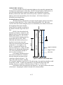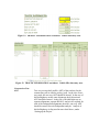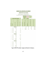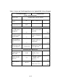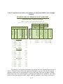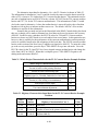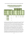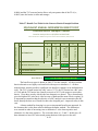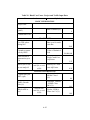
1
APPENDIX A: USER’S MANUAL RSAP Version 3.0.0 NCHRP 22-27 ROADSIDE SAFETY ANALYSIS PROGRAM (RSAP) UPDATE RoadSafe LLC 12 Main Street Canton, Maine 04221 October 25, 2012 TABLE OF CONTENTS List of Figures ................................................................................................................................. 2 List of Tables .................................................................................................................................. 3 Introduction ..................................................................................................................................... 5 Background ..................................................................................................................................... 5 Overview ......................................................................................................................................... 6 General Instructions ........................................................................................................................ 6 Installing RSAPv3 ...................................................................................................................... 6 Opening and Saving a Project ..................................................................................................... 7 Getting Started ............................................................................................................................ 8 Setting up the Project and Preparing the Data for Analysis ............................................................ 9 User Entry of Data .................................................................................................................... 13 Locating Data ........................................................................................................................ 13 Input Modules ....................................................................................................................... 14 Entering the data ........................................................................................................................... 16 PROJECT INFORMATION worksheet ................................................................................... 16 TRAFFIC INFORMATION worksheet .................................................................................... 21 HIGHWAY worksheet.............................................................................................................. 25 ALTERNATIVES worksheet ................................................................................................... 38 Setting up the Alternatives .................................................................................................... 38 Roadside Features ................................................................................................................. 41 CROSS-SECTIONS worksheet ................................................................................................ 46 Conducting the Analysis ............................................................................................................... 52 Preparing the Report and Interpreting the Results ........................................................................ 57 Example Problems ........................................................................................................................ 62 RDG Culvert Example Problem ............................................................................................... 62 RSAPv3 Analysis.................................................................................................................. 70 Cable Barrier Example Problem ............................................................................................... 76 RSAPv3 Analysis.................................................................................................................. 81 Concrete Median Barrier Example Problem ............................................................................. 85 RSAPv3 Analysis.................................................................................................................. 88 Summary ....................................................................................................................................... 92 References ..................................................................................................................................... 98 A-1 LIST OF FIGURES Figure 1. RSAPv3 Splash Screen................................................................................................... 8 Figure 2. RSAPv3 Workflow Diagram. ....................................................................................... 11 Figure 3. Independent Horizontal Alignment. ............................................................................. 12 Figure 4. Independent Vertical Alignment. ................................................................................. 12 Figure 5. Baseline station and offset. ............................................................................................ 13 Figure 6. One-way Road Baseline Location. ............................................................................... 14 Figure 7. RSAP Controls Dialog Box. ......................................................................................... 15 Figure 8. Project Information Data Entry Worksheet. ................................................................. 17 Figure 9. PROJECT INFORMATION worksheet: Basic Information Data Entry Area. .......... 18 Figure 10. PROJECT INFORMATION worksheet: Crash Cost Data Entry Area. .................... 18 Figure 11. Traffic Information data entry area. ........................................................................... 22 Figure 12. TRAFFIC INFORMATION worksheet: Traffic data entry area. ............................. 23 Figure 13. TRAFFIC INFORMATION worksheet: Vehicle Mix data entry area. .................... 23 Figure 14. HIGHWAY worksheet: Whole Roadway Characteristics. ....................................... 26 Figure 15. RSAP Controls Dialog Box for Highway Characteristics. ......................................... 29 Figure 16. HIGHWAY worksheet: User-Entered Characteristics. ............................................. 30 Figure 17. RDG Median Width Measurements. .......................................................................... 32 Figure 18. Example of horizontal curve sign convention. ........................................................... 33 Figure 19. Example of vertical grade sign convention. ............................................................... 34 Figure 20. RSAP Controls Dialog Box for Road Segments: Segment Project to estimate encroachments....................................................................................................... 36 Figure 21. HIGHWAY worksheet: Encroachment review area. ................................................ 37 Figure 22. ALTERNATIVES worksheet. .................................................................................... 39 Figure 23. ALTERNATIVES worksheet: Alternative two data entry area highlighted for data entry. ..................................................................................................................... 40 Figure 24. ALTERNATIVES worksheet: General Hazard Types. ............................................. 42 Figure 25. Example of finding the Station and Offset for a Tree, Sign, or Pole. ........................ 43 Figure 26. Example of finding the Station and Offset for a Terminal. ........................................ 44 Figure 27. Example of Defining a Water Hazard. ....................................................................... 46 Figure 28. RSAP Controls Dialog Box for X-Sections: Copy Defaults and Assign Typical Sections. ................................................................................................................ 48 Figure 29. CROSS-SECTION worksheet. ................................................................................... 49 Figure 30. CROSS-SECTION worksheet: Assign Typical Section to Alternatives by Segments. ............................................................................................................................... 50 Figure 31. CROSS-SECTION worksheet: Edit Typical Sections. ............................................. 51 Figure 32. RSAP Controls Dialog Box for setting analysis criteria. ........................................... 53 Figure 33. Progress Bar at the beginning of the analysis. ............................................................. 56 Figure 34. Progress Bar at Completion of Analysis. ................................................................... 56 Figure 35. RSAP Controls Dialog Box for Results and Different Reporting Options. ............... 58 Figure 36. RESULTS worksheet: Segment and Alternative Cost Summary.............................. 59 Figure 37. RESULTS worksheet: Benefit-Cost Table................................................................ 60 Figure 38. RESULTS worksheet: Feature Collision and Cost Report........................................ 61 Figure 39. Alternative Culvert Treatments. ................................................................................. 63 A-2 Figure 40. RSAPv3 Analysis Settings for the Updated RDG Culvert Example Problem. ........... 70 Figure 41. Progress Bar for the Updated RDG Culvert Example Problem. ................................. 71 Figure 42. RSAPv3 Analysis Settings for Cable Median Barrier Example Problem. .................. 81 Figure 43. RSAPv3 Analysis Settings for TL-5 Concrete Median Barrier Example Problem..... 88 LIST OF TABLES Table 1. Table 2. Table 3. Table 4. Table 5. Table 6. Table 7. Project and Traffic Input Data for the Updated RDG Culvert Example. ...................... 64 Whole Project Characteristics Input Data for the Updated RDG Culvert Example. ..... 65 Highway Characteristics Input Data for the Updated RDG Culvert Example. ............. 65 Alternative 1 Input Data for the Updated RDG Culvert Example. ................................ 67 Alternative 2 Input Data for the Updated RDG Culvert Example. ................................ 67 Alternative 3 Input Data for the Updated RDG Culvert Example. ................................ 68 Alternative 1, 2, and 3 Cross-Section Input Data for the Updated RDG Culvert Example. ............................................................................................................... 69 Table 8. Abridged Feature Collision and Cost Report for the Updated RDG Culvert Example Problem. ................................................................................................................ 72 Table 9. Segment and Alternative Cost Summary for the Updated RDG Culvert Example Problem. ................................................................................................................ 73 Table 10. Benefit-Cost Table for the Updated RDG Culvert Example Problem.......................... 75 Table 11. Project and Traffic Input Data for the Cable Barrier Example Problem. .................... 77 Table 12. Whole Project Characteristics Input Data for Cable Example Problem. ..................... 78 Table 13. Highway Characteristics Input Data for the Cable Example Problem. ....................... 78 Table 14. Alternative 1 Input Data for the Cable Barrier Example Problem .............................. 79 Table 15. Alternative 2 Input Data for the Cable Barrier Example Problem .............................. 79 Table 16. Alternative 1 and 2 Cross-Section Input Data for the Cable Barrier Example Problem. ............................................................................................................................... 80 Table 17. Feature Collision and Cost Report for the Cable Barrier Example Problem. ............... 82 Table 18. Segment and Alternative Cost Summary for the Cable Barrier Example Problem. ..... 83 Table 19. Benefit-Cost Table for the Cable Barrier Example Problem. ...................................... 84 Table 20. Project and Traffic Input Data for the TL-5 Concrete Barrier Example Problem. ...... 85 Table 21. Whole Project Characteristics for the TL-5 Concrete Barrier Example Problem. ...... 86 Table 22. Highway Characteristics Input Data for the TL-5 Concrete Barrier Example Problem. ............................................................................................................................... 86 Table 23. Roadside Input Data for the TL-5 Concrete Barrier Example Problem. ..................... 87 Table 24. Cross-Section Input Data for the Concrete Barrier Example Problem. ....................... 87 Table 25. Feature Collision and Cost Report for the Concrete Barrier Example Problem. ......... 89 Table 26. Segment Cost Summary for the Concrete Barrier Example Problem. ......................... 90 Table 27. Benefit-Cost Table for the Concrete Barrier Example Problem. .................................. 91 Table 28. Blank User Form: Project and Traffic Input Data. ..................................................... 93 Table 29. Blank User Form: Whole Project Characteristics Input Data. .................................... 94 Table 30. Blank User Form: Highway Characteristics Input Data. ............................................ 95 Table 31. Blank User Form: Roadside Feature Input Data. ........................................................ 96 Table 32. Blank User Form: Roadside Cross-Section Input Data. ............................................. 97 A-3 A-4 INTRODUCTION RSAP version 3.0.0 (RSAPv3) is a major update of the Roadside Safety Analysis Program (RSAP), which is distributed with the Roadside Design Guide.[AASHTO06] This updated version incorporates the same basic cost-effectiveness analysis procedure used in previous versions, however, modifies the default data within the software to include new research and incorporates many new algorithms. New features of RSAPv3 include the ability to analyze median crashes, the ability to access and edit default data to account for regional differences or new research, non-linear trajectories, the inclusion of new special hazards like bodies of water and edges of medians, a new probability of collision model that uses real crash data trajectories from the NCHRP 17-22 data and a new probability of injury method for estimating crash severity. This Manual is one of three reports which accompany this software, including an ENGINEER’S MANUAL and a PROGRAMMER’S MANUAL. The USER’S MANUAL is a reference for program users of all experience levels focusing on how to use the software and access its features. This manual provides guidance on the proper entering of data and basic instructions on how to operate the program and perform the analyses. The USER’s MANUAL includes several example problems that illustrate how data should be set up, entered and provides results that can be used to check a user’s first runs. Details of the procedures, the supporting research and data, extensive explanations of the analysis algorithms, background information, explanation of existing software and literature and the potential implementation of this software are provided in the ENGINEER’S MANUAL. The ENGINEER’S MANUAL has information about how to develop and include new severity models or adjustment factors that an advanced user might develop based on their own local data. The PROGRAMMER’S MANUAL documents the program architecture and the pseudo-code and is only useful to those actually modifying the code. The purpose of this manual is simply to teach how to use the software. The ENGINEER’s MANUAL is appropriate to learn how to supplement the default data tables with regional data or new research. The ENGINEER’S MANUAL also provides specific information regarding which models are used in the program, how the models are used, and the supporting research. BACKGROUND The Roadside Safety Analysis Program (RSAP) was originally released in 2003 and documented in NCHRP Report 492. [Mak03] The basic RSAP procedure was included in the 2002 revision of the AASHTO Roadside Design Guide. [AASHTO02] RSAP replaced older software implementations of the cost-effectiveness analysis of roadside designs, including ROADSIDE which was included in Appendix A of the Roadside Design Guide in 1988 [AASHTO88] and BCAP which was used in the 1989 AASHTO Bridge Specification for designing bridge railings. [AASHTO89] RSAP was an innovative implementation of risk-based probabilistic roadside cost-benefit design. Of course, as computer applications became more sophisticated and additional research was performed, it became apparent that an updated version was needed both to take advantage of better computing hardware and user interfaces as well as new research in roadside safety. This A-5 new version, RSAPv3 seeks to improve the user experience by updating the software; make the software easier to update and improve as new research becomes available and integrate improvements to both data and algorithms that have been developed in the 10 years since the original RSAP was released. OVERVIEW This software supports the cost-effectiveness analysis procedure outlined in Chapter 2 of the 2011 Roadside Design Guide.[AASHTO11] Cost-effectiveness is assessed using a benefit/cost (B/C) ratio. Any reduction in annualized crash costs is considered a benefit while direct costs (i.e., maintenance, construction, right-of-way acquisition, etc.) are considered the “cost,” that is, the denominator in the ratio. The B/C ratio is calculated as follows: BCRj/i= where: BCRj/i CCi, CCj DCi, DCj = Incremental B/C ratio of Alternative j with respect to Alternative i, = Annualized crash cost for Alternatives i and j and = Annualized direct cost for Alternatives i and j. Calculating the direct costs is relatively straight forward and has been part of publicly funded infrastructure projects since their inception. Calculating the crash costs can be complicated and relies on predictive models and crash data. RSAPv3 supports the tasks necessary to calculate the crash costs using the encroachment conditional probability model. This model includes a series of conditional probabilities as follows: E(CC)N,M = ADT ∙ LN ∙ P(Encr) ∙ P(Cr|Encr) ∙ P(Sev|Cr) ∙ E(CCs|Sevs) where: E(CC)N,M ADT LN P(Encr) P(Cr|Encr) P(Sevs|Cr) E(CCs|Sevs) = = = = = Expected annual crash cost on segment N for alternative M, Average Daily Traffic in vehicles/day, Length of segment N in miles, The probability a vehicle will encroachment on the segment, The probability a crash will occur on the segment given that an encroachment has occurred, = The probability that an crash of severity s occurs given that a crash has occurred and = The expected crash cost of a crash of severity s in dollars. GENERAL INSTRUCTIONS INSTALLING RSAPV3 RSAPv3 can be obtained either by downloading it from the internet (i.e., http://rsap.roadsafellc.com) or using an installation USB drive. The drive or zip file contains a A-6 setup program (i.e., InstallRSAPv3.exe) that installs the program template, example files, help files and manuals in the C:\Program Files directory. The install program will also link RSAP to the start menu and install a short-cut icon on the desktop for easy access. RSAPv3 was written using Microsoft’s Visual Basic for Applications (VBA) and is coded as an extensive series of macros within Microsoft Excel. A computer with Microsoft Office Excel version 14 or better is needed to use RSAPv3. RSAPv3 will run under any Windows operating system that will also run Office 2010. RSAPv3 has been successfully tested on Windows XP, Vista and Windows 7 operating systems. The Windows 7 Trust Settings strongly discourage running installation programs from the internet. If you choose to install RSAPv3 from the Internet, the following message appears after pressing the installation button: Select “Actions” and another discouraging dialog box, shown at the right, will appear. Select “More Options” and then choose “Run Anyway” and the installation will proceed as intended. OPENING AND SAVING A PROJECT Generally, a new analysis is started by opening the RSAPv3 Excel macro-enabled template either by double-clicking the desktop icon or clicking the start>program>RSAPv3 menu. Once RSAPv3 is initiated, a blank template form with all the macros needed to perform an analysis appears on the screen. The template can be navigated to enter the input data, run the analysis and view the results. Sometimes when a macro-enabled template or workbook is opened for the first time after being saved from either the Internet or from a USB drive, the following message may appear as the workbook opens: Macro-enabled templates and workbooks can be a security issue so Excel offers this warning to ensure complete understanding of the risks prior to opening a workbook that contains a program. For RSAPv3, click “Enable Editing” in order to activate the RSAPv3 macros. If Enable Editing” is not selected RSAPv3 cannot run. Once the “Enable Editing” button has been selected and the file saved this message should not appear again. RSAPv3 and Excel do not allow the template to be overwritten. When finished with a project, the project should be saved as a macro-enabled workbook in another location. This is the default file type and currently the only file type option available for saving. This saved file contains all of the macros used by RSAPv3, therefore, it is a record of the version of the software used in the analysis of the project as well as the data used for the analysis. This project file may be shared with other individuals who do not have RSAPv3 installed. Each individual will have to “Enable Editing” as described above to use the macros available in any project file. A-7 The need to reevaluate a past RSAPv3 project or stop in the middle of data entry may present itself. RSAPv3 provides the ability to read and edit saved project files using the “open existing project” button. RSAPv3 can only read files which were created using RSAPv3. As additional versions of RSAPv3 are developed (i.e., RSAPv3.1, v3.2, etc.) it is anticipated that RSAPv3 will continue to be able to read files created in RSAPv3. Unfortunately, the major coding and data changes that have been incorporated into this version have made it impossible to read project files created before the update to RSAPv3. GETTING STARTED On starting RSAPv3, a splash screen is displayed, shown in Figure 1. This splash screen provides important information about the version of RSAPv3 and the version of MS Excel and Windows installed on your computer. RSAPv3 has been developed for continual updating of the supporting data and research using the analysis. Projects which use RSAPv3 for analysis of roadside alternatives should note the version used in the project report which documents the analysis. Noting the version of the software is one way to identify exactly which version of the software was used in your analysis. . Figure 1. RSAPv3 Splash Screen. The splash screen disappears after a few seconds and the program opens to the PROJECT INFORMATION worksheet. A pre-made Excel worksheet (i.e., Project Information) will appear on the right 2/3rds of the screen and the RSAPv3 control dialog box will appear at the left 1/3rd of the screen. RSAPv3 is comprised of a series of data entry and data storage worksheets and a Dialog Box to aid User Interface with the software. Data is entered and displayed through a series of worksheets which include: Project Information, Traffic Information, Highway, Alternatives, Cross-sections, A-8 Analyze, Results, Settings, and Hazards. The work-flow process for preforming an analysis follows the same order as the worksheets and the RSAP Controls Dialog Box provides a step-by-step walk through the data entry and analysis process. Correctly entering data into RSAPv3 is essential to achieving accurate results. The cost-effectiveness procedure implemented in RSAPv3 generates a cost/benefit ratio for roadside design alternatives under consideration. The agency costs for each alternative (i.e, construction, maintenance, right-of-way, etc.) are entered, the crash costs for each alternative are determined by RSAPv3. The alternatives’ Benefit/Cost ratios are then compared to determine the preferred alternative. The crash cost of each alternative is determined by (1) estimating the encroachment frequency of homogeneous segments of a project; (2) adjusting the encroachment frequency to account for variations from base conditions; (3) determining the probability that encroachments will result in roadside crashes; and (4) determining the likely crash cost of the roadside crashes. Much of this analysis relies on data which is stored within RSAPv3, however, the project specific data (i.e., agency costs, highway characteristics, alternative roadside deigns, etc.) are entered for each analysis. The following sections discuss setting up the project and preparing the data for analysis, entering the data, conducting the analysis, preparing the report and interpreting the results. SETTING UP THE PROJECT AND PREPARING THE DATA FOR ANALYSIS The RSAPv3 input and analysis workflow is shown in Figure 2. The first five steps in the RSAPv3 workflow require project specific data while the remaining steps rely on data stored within the software. The last section of this manual includes blank user forms for gathering project data. This manual described the proper entry and analysis of project data to obtain accurate results. Prior to gathering, entering and analyzing data, the first question which must be addressed in what type of highway will be analyzed? RSAPv3 bases most of its default information on the highway type chosen where the choices are a divided highway, an undivided highway and a one way road. Undivided Divided An undivided highway has one baseline down the center of the alignment. Traffic moves in two directions and the volume is proportion by the traffic split variable. Four types of encroachments are possible: (1) primary encroachments left, (2) primary encroachments right, (3) opposing encroachments left and (4) opposing encroachments right. A divided highway may have one or two baselines. Each baseline is analyzed separately. Highways with dependent (parallel) vertical and horizontal alignments have one baseline with the baseline at the center of the highway. The four encroachments listed for Undivided highways are possible. The traffic volume is assigned to each direction using the traffic directional split variable. A-9 Highways with independent alignments such as shown in Figure 3 and Figure 4 have two baselines and should be analyzed as two one-way highways. One-way A one-way highway can be a one-way street or a ramp or a divided highway on an independent alignment. It is represented by one baseline. The baseline is located at the left edge of travel. The traffic volume is assumed to be distributed 100 percent to the baseline. Only two types of encroachments are possible: encroachments left and right. A-10 PROJECT TRAFFIC HIGHWAY ALTS X-SECTION ANALYSIS RESULTS •Basic Information •Economic Information and Crash Costs •Traffic Information •Vehicle Mix •Whole Project •Road Segments •Roadside and median feature data •Roadside and median crosssection alternatives. •Trajectory Settings •Cost/Benefit Ratio •Crash frequency by feature •Crash cost by segment Figure 2. RSAPv3 Workflow Diagram. Figure 3. Independent Horizontal Alignment. Figure 4. Independent Vertical Alignment. USER ENTRY OF DATA Previous versions of RSAP required the highway to be manually segmented into homogeneous segments prior to data entry. RSAPv3 accepts highway characteristics in any order and automatically segments the highway into homogeneous segments. Roadway characteristic data can be entered in any order, as RSAPv3 segments the highway and sorts the hazard data prior to the analysis. All of these features are described in more detail below. A-13 2+10.00 + 65.12’ 2+75.12 + Locating Roadway Features All characteristics and hazards are located using the highway design convention of baseline station and offset. This is a little different than RSAP 2.0.3 and earlier versions where the location along the project was identified by the distance in feet from the beginning of the project and the lateral offset to a hazard was defined as the distance from the edge of the travel lane. RSAPv3 uses the method used by highway designers, contractors, and highway software where the location is 22’ based on the station (i.e., 02+75.12 is 275.12 feet from the starting point for a project that starts at 0+00). Each 12’ 8’ undivided and divided roadway has a baseline located at the center and offsets are measured from the baseline to the left (i.e., L) or right (i.e., R). RSAPv3 considers the baseline for Edge of Shoulder one-way roadways (i.e., ramps, divided highways with independent alignments, Edge of Travel etc.) to be located at the left edge of Base Line travel, as shown in Figure 6. For example, an undivided twolane rural road would have a baseline that runs along the pavement section centerline as shown in Figure 5. The Figure 5. Baseline station and offset. edge of the right travel lane, assuming a 12 foot lane, would have an offset of 12’R and the edge of an eight foot shoulder would be an offset of 20’R. A small sign positioned two feet from the edge of the right shoulder, therefore, would have a baseline offset of 22’R (i.e., 12+8+2=22). Note that the offset measurement to the hazard (i.e., the sign) is taken to the center of the hazard. Assigning the width of a hazard will be discussed later. 2+75.12 + 20’ 2+10.00 + 65.12’ 15’ Right edge of travel Baseline and left edge of travel Figure 6. One-way Road Baseline Location. Input Modules Project characteristics are entered in five worksheets with assistance from the RSAPv3 Controls Dialog Box. Each worksheet has multiple data entry areas. The default hazard information is stored on one sheet, the analysis results are displayed on another sheet. The names and the types of data entered for each data entry worksheet are as follows: PROJECT INFORMATION worksheet: Basic Information, Economic Information and Crash Costs. TRAFFIC INFORMATION worksheet: Traffic Information and Vehicle Mix. HIGHWAY worksheet: Roadway and Road Segment Characteristics. ALTERNATIVES worksheet: Roadside and median hazard data. CROSS-SECTIONS worksheet: Roadside and median cross-section alternatives. The data entry worksheets (i.e., PROJECT, TRAFFIC, HIGHWAY, ALTERNATIVES, AND X-SECTION) , the default HAZARD information worksheet, and RESULTS worksheets are all displayed as tabs in RSAP Controls Dialog Box like the one shown in Figure 7. The ANALYZE tab is used to access the analysis options, but does not access a worksheet. A-14 The RSAP Controls Dialog Box contains context sensitive prompts and context sensitive button controls to help with data entry. This dialog box is consistently displayed on the left side of the screen, however, it can be moved or resized. Hints about the appropriate next step are displayed at the bottom-left of the dialog box and the worksheet specific buttons are displayed along the right panel of the box. The left panel of the box provides tabs to navigate between the different worksheets and input tasks. For example, Figure 7 has a hint prompt at the bottom of the sheet which provides instruction to “Change any of the default values in the yellow or rose cells or proceed to the next section by selecting ‘Traffic Info.’” The buttons in the right panel can be used to “Start a New Project,” “Open Existing Project,” “Clear User Information” or “Restore RSAP Defaults.” Each RSAP Controls Dialog Box provides the option to clear the user information. These buttons will only clear the information on the current worksheet; they do not clear information on other worksheets. Each RSAP Controls Dialog Box also provides a button to restore the RSAPv3 default values. The default values are shown in rosecolored cells. Again, this button will only restore the default values on the current worksheet. To restore the values on other worksheets, that worksheet must be active and the appropriate buttons used there. In contrast to the other “clear” buttons, the “Start a New Project” button on the PROJECT INFORMATION tab will clear all the user-entered information from all worksheets and restore the RSAPv3 defaults to all worksheets so that a new project can be started with a clean workbook. The RSAP Controls Dialog Box hint box is a valuable asset when not sure which step to take next. The context sensitive prompts at the bottom of the box assist in program workflow comprehension and provide direction toward the next step. The controls in the left panel assist in navigation from one worksheet and input task to the next. Figure 7. RSAP Controls Generally, the data entry should proceed Dialog Box. smoothly using the tabs and buttons in the RSAPv3 Controls Dialog but if the RSAP Controls Dialog Box is inadvertently closed or disappears for any reason it can be reopened by selecting CTRL-S on the keyboard. All the data entered up until this point will still be in the worksheets so data entry and analysis can proceed as usual. A-15 RSAPv3 is optimized for data entry and analysis following the left panel buttons from top to bottom (e.g., PROJECT, TRAFFIC, HIGHWAY, etc.). The following sections discuss the data entry of information and the default data available in these worksheets. ENTERING THE DATA PROJECT INFORMATION WORKSHEET A Complete view of the PROJECT INFORMATION data entry area and the RSAP Controls Dialog Box is shown in Figure 8. Basic information about the project is entered on this worksheet. Figure 9 and Figure 10 show excerpts from the PROJECT INFORMATION worksheet where the Basic Information and the Crash Cost data are entered. The rose colored cells contain RSAPv3 default values which may be edited; the yellow cells represent project specific data which must be added; all other cells are protected and cannot be edited. For example, the yellow cell below requests the Project title. The project title entered is “RDG Culvert Example Problem.” Each project will presumably have a different title, therefore this cell is yellow. In addition to the Project title, Figure 9 also has data entry areas for the Design life in year, the Construction year and the rate of return. Default values for these rose colored cells are provided, but may be edited by the user to conform to the specific project. As the default, RSAPv3 provides the 2009 Value of Statistical Life (VSL) of $6,000,000 and the source of this information. More information can be found on the change to VSL in the RSAPv3 Engineers Manual. Each of the data entry fields and the data entry requirements shown in these figures are discussed in detail below. A-16 Figure 8. Project Information Data Entry Worksheet. Figure 9. PROJECT INFORMATION worksheet: Basic Information Data Entry Area. Figure 10. PROJECT INFORMATION worksheet: Crash Cost Data Entry Area. Today's date This field is automatically generated by RSAPv3. It will be regenerated every time the project file is opened with the current day’s date. Title This field represents the title of the project. This value is carried through on all data entry worksheets and the RESULTS worksheet. A value which is unique and representative of the project under evaluation should be used. Units RSAPv3 currently accepts data only in US Customary Units (USCU). Future updates are planned to incorporate the International system of Units (SI). The default value is USCU. Design Life The design life of the project, expressed in years. A typical value is 25 years for new or reconstruction projects or 10 years for resurfacing projects. The design life starts when the project construction is complete and the project is open to traffic. The design life is the period of time where the construction cost can be amortized. It is presumed that the project will be re-constructed at the end of its design life and there will be no salvage value. Construction Year The Construction Year represents the planned year of construction completion when the facility will be opened to traffic. Rate of Return The Rate of Return is the ratio of money gained or lost (whether realized or unrealized) on an investment relative to the amount of money invested, expressed as a percentage. The default value is 4%. This value is also sometimes called the discount rate. It is used to amortize the construction cost over the design life of the project. Use GDP values during life? RSAPv3 will use or not use the Gross Domestic Product (GDP) price deflator over the project life in the Cost/Benefit calculations to adjust the crash cost. The default value is N for no. Not using the GDP during the life of the project means that the VSL is adjusted to the construction year and the construction year VSL is used in the economic analysis. Change the value to Y for yes to expand Crash Costs values over the life of the project. For example, if the crash cost year value is 2009, the construction year is 2013, and the design life is 20 years (i.e., 2023) the crash costs will be $7,019,151 in 2013 when the facility opens and increase yearly until the Crash Costs are $18,711,090 in 2023. A-19 Generally, the economic analysis is based on deflating all costs to the construction year so the default is “no.” Expand to current year by GDP? GDP Deflator Base year for crash cost data Value of Statistical Life Similar to using the GDP values during the project life as described above, RSAPv3 will also expand or not expand the crash cost values to the construction year using the user entered GDP price deflator. The default value of Y for yes will expand the crash costs to the construction year. Changing the value to N for no will not expand the crash costs of the construction year. See the discussion below on Value of Statistical Life (VSL) for the appropriate expansion of crash cost figures. The FHWA periodically issues recommendations for the VSL, the last being in 2009. Selecting “yes” will adjust the value to the construction year and selecting “no” will leave the value unadjusted. The assumed Gross Domestic Project (GDP) Deflator, expressed as a percent, for calculating time series costs. The default value is 4%. A hyperlink is provided within the program which links to the U.S. Government’ Printing Office website, which has the current federally recommended GDP deflator values. The base year for crash cost data is the year associated with the particular VSL. At the time of this publication, the 2009 crash cost data published by FHWA was the most recent crash cost data available. This data has been included as the default year. When FHWA updates these values they may be entered and the year of the data specified in this field. Older crash cost data may also be entered for a variety of reasons. In any case, the data year corresponding to the VLS used should be entered in this field. This year is used in a number of calculations related to adjusting the crash cost values from the base year to the construction year and over the design life, as described above. It is also important to record, regardless of whether the VSL is adjusted or not, the year to which the VSL is tied for future reference. The Value of Statistical Life (VSL) represents the average comprehensive crash cost of a fatal crash. Based on new interpretation of the literature, FHWA plans to annually release a new VSL and move away from using the GDP to inflate crash costs. The VSL is to be used in combination with the relative crash costs shown in Figure 10. The most recent VSL released by FHWA at the time of this publication was $6M in 2009. An A-20 option to inflate the VSL using the GDP has been included in the event annual releases of VSL are not forthcoming. See the discussion above for “Expand to Current Year by GDP.” The VSL can be thought of as the comprehensive crash cost of a fatal crash. After completing data entry in all of these fields, pressing the “Traffic Info” button on the RSAP Controls Dialog Box will initiate the TRAFFIC INFORMATION data entry worksheet. TRAFFIC INFORMATION WORKSHEET A Complete view of the TRAFFIC INFORMATION data entry area and the RSAP Controls Dialog Box for this worksheet is shown in Figure 11. Figure 12 and Figure 13 show excerpts from the TRAFFIC INFORMATION worksheet where the project specific Traffic Information and the Vehicle Information is entered. As true on every sheet, the rose colored cells contain RSAPv3 default values which may be edited or accepted as-is. The yellow cells require project specific data and all other cells are protected and may not be edited. A-21 Figure 11. Traffic Information data entry area. Figure 12. TRAFFIC INFORMATION worksheet: Traffic data entry area. Figure 13. TRAFFIC INFORMATION worksheet: Vehicle Mix data entry area. Construction Year ADT Two-way average daily traffic (ADT) of the roadway for the construction year in vehicles per day (vpd). In the case of oneway roads, the one-way ADT should be entered. In the case of divided highways on the same alignment, the bi-directional ADT should be entered. In the case of divided highways on separate alignments, separate RSAPv3 analysis are required for each of the independent alignments, therefore, one-way ADT should be entered for each independent analysis. Analysis of divided highways is discussed in more detail above, under “Setting up the Project.” Traffic Growth Rate Which ADT to use? Vehicle Type Vehicle Crash Cost Adj Factor Annual traffic growth rate, expressed as a percent. Positive and negative values are acceptable. The Average Daily Traffic (ADT) value (i.e., construction year, mid-life or end-of-life) to be used in determining the encroachment frequency may be specified here. The RSAPv3 default value is Mid-Life ADT. The mid-life ADT value represents an approximate average annual value of traffic volume over the life of the project, therefore using this value to predict encroachment frequency will predict the average annual encroachment frequency over the life of the project. RSAPv3 currently recognizes three vehicles types by default: Motorcycles (i.e., FHWA class 1), Passenger Vehicles (i.e., FHWA class 2-3) and Trucks (i.e., FHWA class 4-13). The entered Vehicle type distribution is used in the trajectory module. Vehicle characteristics are distributed across the trajectories using the values shown. The default values are zero percent motorcycle, 90 percent passenger vehicles, and 10 percent trucks. The values may be changed, as appropriate for the project, however the total distribution must equal 100 percent to proceed to the next screen. Additional types of vehicle may be added but not by the casual user. Procedures for adding vehicle types are included in the ENGINEER’S MANUAL. The severity distributions of crashes used within RSAPv3 was developed from police-level crash records which represent predominantly passenger cars. The average crash costs represented by the VSL represent the general vehicle fleet which is predominantly composed of passenger cars. It becomes difficult, therefore, to distinguish between different crash costs in areas dominated by heavy vehicles or in scenarios where a particular vehicle-type is of greater concern (e.g., possibly installing a higher test level barrier) if crash costs for all vehicles types are lumped together in the VSL. A Crash Cost Adjustment can be supplied for each vehicle type in the right portion of the vehicle mix table. A factor of 3.52 is the default value for trucks; passenger vehicles should always remain at 1.0 and motorcycles are 0.56. According to these default adjustments, a typical truck crash has a crash cost that is more than 300% greater than the typical passenger car collision and a typical motorcycle crash has a crash cost that is 56% of a typical passenger car collision. This value may be changed if local data are available. A value of 1 should be used when no A-24 adjustment is desirable. More information on how this value was derived can be found in the ENGINEER’S MANUAL. Upon completing the data entry in these fields, press the “HIGHWAY” tab on the RSAP Controls Dialog Box to initiate the HIGHWAY characteristics worksheet. HIGHWAY WORKSHEET The HIGHWAY worksheet is where the horizontal and vertical alignment of the project, the lane width, number of lanes and other project related highway characteristics are entered. Highway characteristics entered on this worksheet are common to all alternatives. RSAPv3 is designed to evaluate different roadside designs, not different roadway geometric designs. RSAPv3 cannot be used, for example, to look at the difference in crash frequency due to changes in alignment; there are other tools like the FHWA’s IHSDM software that evaluate different alignment choices. In order to compare roadside designs directly to each other, the roadway characteristics must be kept the same for all roadside alternatives and the characteristics entered on this worksheet will be common to all alternatives. This worksheet has two main data entry areas, the Whole Roadway Characteristics and user-entered Characteristics. The RSAP Controls Dialog Box helps in navigation. The Whole Project Characteristics are requested first. This data entry area is shown circled in red in Figure 14. The whole project characteristics include the percent of traffic in the primary direction, percent of traffic encroaching right, the highway type, the terrain, the posted speed limit, and the user encroachment adjustment. The RSAPv3 default values shown in the rose colored cells may be accepted as is or edited. The whole-project characteristics are defined below. A-25 Figure 14. HIGHWAY worksheet: Whole Roadway Characteristics. Percent of Traffic In the Primary Direction Percent of Traffic Encroaching Right Percent of traffic in the primary direction is similar to the traffic engineering concept of directional distribution of traffic. Given an undivided highway with an ADT of 10,000 vpd, with baseline stationing that runs from the south to the north (i.e., northbound is the primary direction) and where 6,000 vpd travel south, the percent of traffic in the primary direction equals 40. That is, 6,000/10,000=60 percent of the vehicles are traveling south. North is the direction of the baseline stationing so north is the primary direction so 100% - 60% = 40 percent of the vehicles are traveling in the primary direction. For one-way streets and divided highways on separate alignments, 100 percent of the vehicles travel in the primary direction. The RSAPv3 default for divided and undivided highways is 50%. The percent of traffic encroaching to the right has a default value of 50 percent. Values between 0 and 100 are accepted. Values of 0 indicate that no vehicles are encroaching right and all generated encroachments would be modeled on the left side of the road. The number of generated encroachments, however, is not reduced; therefore the number of left side encroachments would be doubled under this scenario. Conversely, a value of 100 would indicate that all encroachments should be modeled on the right side of the road. The default value of 50 percent models half of the encroachments on the right side of the road and half on the left side of the road. This value should not be changed unless a study has been conducted or specific information gathered which indicates that the distribution of encroachments is other than 50-50. Highway Type Highway type includes undivided, divided, and one-way roads. Interstate and arterial exit/entrance ramps should be modeled as one-way roads. Divided highways include roadways on the same coordinated alignment. Divided highways on separate alignments should be modeled independently as two different one-way roads. Terrain The terrain refers to the overall project and not specific segments. The definition is similar to what is used in other highway design manuals like the Highway Capacity Manual. Acceptable entries include flat, rolling, or mountainous. This entry adjusts the base encroachment frequency. Posted Speed Limit The posted speed limit of the roadway, in miles per hour, should be entered in this field. User Encroachment Adjustment This field should be used with extreme caution. The default value is 1.0, meaning there are no adjustments made to the encroachment frequency by this factor. When historic crash data is available for comparison and/or benchmarking the results of an analysis, changing this adjustment would be appropriate to achieve results which match the historic data prior to conducting an analysis of future conditions. Upon completion of the whole-project data entry, the “Enter Highway Characteristics” button shown circled in Red on the RSAP Controls Dialog Box in Figure 15 should be pressed. The highway characteristics entered on this worksheet are used to calculate an adjusted encroachment frequency for each homogenous segment of the project. A feature new to RSAPv3 is the automatic segmenting of the project. Highway characteristics are now entered in any order and RSAPv3 will organize this data into homogenous segments. For example, all of the vertical alignment data may be entered, then the horizontal alignment data, then the number of lanes. Alternatively, a horizontal curve, then a portion of vertical alignment, then some data on lane widths, then more data on horizontal alignments may be entered. Regardless of the order of data entry, RSAPv3 will create homogeneous segments for analysis. Error checking features have been added to ensure that the data entered does not overlap (e.g., conflicting horizontal alignment data cannot be entered for the same location). RSAPv3 can accommodate up to 20 different highway segments of any length. A-28 Figure 15. RSAP Controls Dialog Box for Highway Characteristics. Upon pressing the button circled in red above, the User-entered Highway Characterics area of this worksheet is revealed for data entry (Figure 16). The method used to reference and locate items within RSAPv3 was explained above under “Locating Data.” Each highway characteristic is explained below. A-29 Figure 16. HIGHWAY worksheet: User-Entered Characteristics. The user-entered characteristics include the horizontal and vertical alignment, the travelled way cross section, the presence of a median and the many other highway features. If a characteristic is not defined during data entry, RSAPv3 uses a default value. For example, if the lane width is not specified, the default lane width of 12-ft for all segments is used in the analysis. Similarly, if the access density is not specified, the default access density of zero points/mi for all segments is used in the analysis. Only values which differ from the defaults need to be entered. For example, if all lanes in the project are 12-ft wide, that information does not need to be entered since RSAPv3 will assume the default values. The RSAPv3 defaults for the highway type selected are indicated in the descriptions below and shown on the worksheet to the right of the data input area, as shown in Figure 16 Entering a characteristic which matches the default value will not cause any additional adjustments, however, an additional segment may be added to the analysis. For example, the default access density is zero. The project has an access density of zero. Adding access density for a small length of the project and setting the value equal to zero will cause an additional segment to be added to the analysis, however, will not impact the encroachment rates as the value is equal to the default value. This may be useful to consider when the results for a portion of a homogeneous segment are needed. These user-entered characteristics are discussed below in the order they appear in the software (i.e., alphabetical order of the RSAPv3 keyword). The valid options are available in a dropdown menu in the “Keyword” column of the input form (Figure 16). Access Density The default access density is zero access points per mile for all highway types. An increase in access density results in an increase in encroachment rates. An integer between 0 and 50 which represents the number of access points per mile between the indicated stations should be entered. For example, if the access density remains relatively constant throughout the project, the start and end stations for the entire project should be entered along with the corresponding number of access points per mile. If the access density varies considerably over the length of the project, the start and end station and the corresponding access density for the first section should be entered and then for each region which has a change in access density per mile. The RSAPv3 characteristics keyword for data entry is “ACCESS DENSITY.” Total Lanes Total lanes refers to the total number of lanes in both directions of the roadway. The default total number of lanes is four lanes for divided highways; two lanes for undivided highways and one lane for one-way roads. An integer between 1 and 10 represents the total number of lanes between the indicated stations. Regardless of the highway type, the integer entered is the total number of lanes. The RSAPv3 characteristics keyword is “LANES TOTAL.” For example, a two-lane exit ramp being examined, LANES TOTAL=2. A five-lane divided highway where both directions are on the same alignment and 3 lanes are in the primary direction and 2 are in the opposing direction is LANES TOTAL=5. The default lane width is 12 feet for all highway types. This default value can be changed by entering the RSAPv3 Keyword “LNWIDTH” and an integer between 8 and 20. The entered value should represent the average lane width in feet for all lanes in the range of the designated stations. Lane Width Median Shoulder Width Median Width Enter a real number between 0 and 20 feet to represent the median shoulder width. Measurements are taken from the solid yellow edge line (SYEL) to the median treatment (i.e., curb, barrier face, grass, etc.) If a SYEL is not striped, the median shoulder width is zero. The RSAPv3 keyword is “MED_SHLR_WIDTH.” The median shoulder width is assumed to be the same for the primary and opposing direction of travel. The default median width for divided highways is 10 ft. and is undefined and will result in an error for one-way or undivided highways. The median width represents the combined width of the median treatment (i.e, curb, barrier, grass, etc.) and the median shoulders (see Figure 17) as defined by the Roadside Design Guide.[AASHTO11] The width of a median protected by concrete barrier with two foot shoulders might be six feet (2’ barrier width + 2-2’ shoulders=6’). Therefore, the starting and ending station of the median should be entered with the RSAPv3 keyword “MED_WIDTH” and a value of 6 should be entered representing the median width for this example. Real number between 0 and 150 are accepted values. The default median width is 30 ft for divided highways and is undefined for one-way or undivided highways. Travelled Way Shoulder Travelled Way Median Width Figure 17. RDG Median Width Measurements. A-32 Primary Curve Radius The radius of horizontal curvature, entered in feet with positive values being curves to the right in the direction of increasing stations (i.e., primary direction) and negative values being curves to the left in the direction of increasing stations (Figure 18). The default value is tangent. The RSAPv3 keyword is “PRM_CURV_RAD” and real number between -10,000 and 10,000 are accepted. Curve radii larger than 10,000 are assumed to be for all intents and purposes to be tangent since the encroachment adjustment factor for radii greater than 10,000 ft is one. INCREASING STATION Positive Curve Radius Negative Curve Radius Figure 18. Example of horizontal curve sign convention. Primary Grade The grade of the roadway as a percent. The default value is zero percent for all highway types. Positive values are up-hill in the direction of increasing station and negative values are down-hill in the direction of increasing stations (Figure 19). The RSAPv3 A-33 keyword is “PRM_GRADE.” Real numbers between +/-20 are acceptable values. Negative Grade Positive Grade INCREASING STATION . Figure 19. Example of vertical grade sign convention. Primary Number of Lanes Rumble Strips The default number of lanes in the primary direction is half the value entered for LANES TOTAL above when the total number of lanes is an even number. When the total number of lanes is an odd number, the default value for the number of lanes in the primary direction is half the value of the total number of lanes rounded up to the next integer. To change this default enter the RSAPv3 keyword “PRM_NUM_LNS”, the beginning and ending stations and an integer value between 1 and the total number of lanes. For example, a five-lane divided highway with three lanes on the opposing direction (i.e., decreasing stationing) and two on the primary direction would be entered using a combination of LANES TOTAL=5 and PRM_NUM_LNS=2. The presence or absence of shoulder rumble strips. The default value is the absence of rumble strips or FALSE for all highway types. The RSAPv3 keyword is “RMBLSTRIP.” A value of TRUE indicates that shoulder rumble strips are present for the stations indicated while a value of FALSE indicates there are no shoulder rumble strips. A-34 Right Shoulder Width The right shoulder width is assumed to be equal for the primary and opposing direction of travel and the default is 6 ft for all highway types. Enter a real number between 0 and 20 feet to represent the right shoulder width. Measurements are taken from the solid white edge line (SWEL) to the edge of road (i.e., curb, sidewalk, grass, etc.) The shoulder may be paved or gravel. If a SWEL is not striped, the right shoulder width is zero. The RSAPv3 keyword is “RT_SHLR_WIDTH .” The characteristics discussed above are used by RSAPv3 to determine the adjusted encroachment frequency and trajectory paths for each segment. After entering these characteristics, the next step is to create homogeneous segments and estimate the encroachments for each segment. This is accomplished by selecting the “Segment Project” button circled in red in Figure 20. This will generate homogeneous segments and estimate the encroachments for each segment. You must select the “SEGMENT PROJECT” button in order for RSAPv3 to segment the project and calculate the adjusted encroachment frequency for each segment. A-35 Figure 20. RSAP Controls Dialog Box for Road Segments: Segment Project to estimate encroachments. After the “Segment Project” button is selected, RSAPv3 calculates the base encroachment frequency, applies the appropriate adjustments, estimates the adjusted encroachment frequency by segment and displays the results (Figure 21). Select the "See Road Characteristics” button or the “See Encr Estimate” button to toggle between the segmented highway characteristics and the adjusted encroachment frequency estimates. The default whole-project characteristics may be restored or the whole project characteristics may be edited by selecting the appropriate buttons. If the whole-project characteristics are edited after segmenting the project, the “Re-calculate Encroachments” button must be selected before moving on to the next input worksheet. The road characteristics may be edited, modified and changed until the results are satisfactory. When the results are satisfactory, and the “Segment Project” button has been selected for the last time, “Re-calculate Encroachments” then select the “ALTERNATIVES” tab on the RSAPv3 Control Dialog Box. A-36 Figure 21. HIGHWAY worksheet: Encroachment review area. ALTERNATIVES WORKSHEET The ALTERNATIVES worksheet is where data is entered for the comparison of different roadside design alternatives. RSAPv3 allows for the comparison of up to five different roadside alternatives. The number of alternatives to consider, the agency cost for each alternative, and the location and type of roadside hazards specific to each alternative are entered on this worksheet. Recall RSAPv3 is specifically designed to consider roadside design alternatives. This worksheet allows for considerable variation in the configurations and locations of roadside hazards across all alternatives. Perhaps there are small changes between alternatives, or perhaps there are large changes between alternatives. Maybe some roadside features remain constant throughout all of the alternatives. This worksheet provides opportunities to customize roadside designs under consideration and also copy data already entered to minimize re-entry of data. All of these options are discussed in this section. Setting up the Alternatives Although not in the spirit of a benefit-cost analysis, RSAPv3 can be run with only one alternative in order to examine the expected number of crashes and associated crash costs of a particular roadside design. A benefit-cost analysis will require at least two alternatives. Currently RSAPv3 will evaluate up to five alternatives simultaneously. Generally, alternative 1 represents the current site conditions or null condition of the site if nothing is done. RSAPv3 does not assume this in analyzing the data but it is good practice to establish the baseline conditions as alternative 1. It is useful though not essential to organize the alternatives in increasing construction cost order. RSAPv3 does not require this but the results are easier to interpret if the alternatives are arranged by increasing construction cost. Figure 22 and Figure 23 provide examples of the ALTERNATIVE worksheet. Particular attention should be paid to the RSAPv3 Controls Dialog Box. Figure 22 does not have any data entry areas highlighted in yellow. First, an alternative must be selected on the RSAPv3 Controls Dialog box. After an alternative is selected, the data entry area is yellowed as shown in Figure 23 and data entry is permitted. The RSAP Controls Dialog Box may be used to switch between alternatives, copy alternatives, and delete alternatives. An option is offered to “Copy Alt” or “Delete Alt.” After completing data entry for an alternative, the “copy alt” button may be used for instances with a considerable amount of the same roadside features are present in more one alternative. For example, maybe the Null alternative is an unprotected culvert headwall and Alternative 1 is to protect the headwall with guardrail. Both alternatives will have the same roadside features, except Alternative 1 will also have guardrail. After entering the roadside hazards, as described below, press the “Copy Alt” button and indicate that Alternative 1 should be copied. Guardrail may be added to Alternative 2 and the construction cost changed. This option will save considerable data entry time. Entering the roadside hazards is described below. A-38 Figure 22. ALTERNATIVES worksheet. A-39 Figure 23. ALTERNATIVES worksheet: Alternative two data entry area highlighted for data entry. A-40 Roadside Features Roadside features include anything outside the travelled way which may influence the crash potential of an errant vehicle. Items range in scope from the roadside hardware specifically designed for placement on the roadside (i.e., guardrail, guardrail terminals, crash cushions, etc.) to trees and other naturally occurring hazards. Other objects such as utility poles, signs and mailboxes can be positioned on the roadside. RSAPv3 also includes a number of new “special edges” like the edge of the median to detect median cross-overs, the edge of a water body, as well as the clear zone edge. Default hazard severities have been provided with RSAPv3 for roadside hazards. These values are stored on the SEVERITY worksheet. The RSAPv3 ENGINEER’S MANUAL contains a detailed discussion on the development of these severities and provides instructions to collect data and develop severities for new hazards or for hazards using regional data. The severity information may be viewed by selecting the “Hazard” button, but the values cannot be changed in the SEVERITY worksheet. Instructions for adding or editing hazard information in the SEVERITY worksheet are in the ENGINEER’S MANUAL. Roadside hazards are located using the baseline station and offset method described earlier. Recall, the offset is measured from the center of the hazard perpendicular to the baseline and the direction of offset (i.e., Left or Right of the baseline) is specified. Hazards which have an associated length (e.g., longitudinal barrier) should be entered using the beginning and end Stations and offsets. Point hazards (e.g., trees, poles, signs, etc.) should be entered using a single station and offset and the hazard diameter. Point hazards include trees, poles, bollards, the ends of guardrail terminals, and other fixed objects which do not have an area or length but which can be represented as a point in space. Line hazards include longitudinal barriers, the edge of a clear zone, the edge of a median, and any other objects which can be represented as a simple line. One notable change in RSAPv3 from previous versions is culvert ends have been removed from the hazard categories. Culverts are complicated structures which cannot be properly modeled as a single roadside hazard, but require modeling more like that of a bridge. For example, the roadside slopes, the headwall, the presence of a longitudinal barrier, and different grading options should be entered individually. The ALTERNATIVES worksheet has hazard sensitive menus which aid in data entry for the seemingly endless set of roadside hazards which an errant vehicle may encounter when it leaves the road. This large range of hazards can be grouped first into a General type, then a specific hazard. Figure 24 shows some possible choices. After selecting the general type (i.e., Bridge Rails, Crash cushions, Median Barriers, PoleTreeSign, Special edge, etc.,), the Specific Hazard Type pull down menu and the remaining data entry fields to the right are formatted to accept the appropriate data for either points or lines as described above. A-41 Figure 24. ALTERNATIVES worksheet: General Hazard Types. Point Hazards As discussed above, point hazards are any object on the roadside or in the median that can be represented as a single point in space. Generally speaking, a point hazard would be any object whose actual length and width are less than about three feet (i.e., about half the width of a passenger vehicle). Tree, Poles, Signs The station and offset of a single tree may be specified. RSAPv3 will then ask for the diameter of the tree. The same procedure is used for other similar objects like poles, signs and luminaire supports. Figure 25 provides an example. The photo is taken looking in the primary direction of travel, so the direction of the offset is Right. The distance of offset is measured from the baseline (e.g, the baseline is the centerline of an undivided road) to the center of the hazard. A-42 Offset X feet from the Baseline to the Pole. Figure 25. Example of finding the Station and Offset for a Tree, Sign, or Pole. Terminals Modern, crash tested longitudinal barrier terminals are complex devices which are designed for two basic impact conditions: (1) end-on impacts and (2) length-of-need impacts. The hazard severity included in RSAPv3 represents impacts only at the end of the terminal (i.e., prior to the length-of-need). The station and offset of the traffic-end of the terminal should be specified when a terminal is present. The length of need of a terminal should be modeled using the w-beam guardrail hazard, specifying the start and end stations and offsets. In other words, the length of the terminal is not specified specifically under the terminal hazard. The length of need stations and offsets and the terminal end station and offset are coincident and should be entered as such. Additionally, the length of need and the barrier the terminal is attached to are coincident. It is important that coincident points be entered correctly; otherwise, RSAPv3 will stop the analysis and require the terminal definition on the ALTERNATIVES worksheet be corrected. Figure 26 provides an example. The photo is taken looking up-station (i.e., in the primary direction of travel), A-43 therefore the direction of offset is Right. The distance of offset is measured from the baseline (e.g, the baseline is the centerline of a road) to the hazard. The width of the terminal head is also requested. This value should be entered in the “value” field. W-beam hazard with begin and end station and offset. Terminal length-of-need defined as w-beam hazard with begin and end station and offset. Offset X feet from the Baseline to the Terminal Hazard. Figure 26. Example of finding the Station and Offset for a Terminal. Line Hazards As discussed above, line hazards are any object on the roadside or in the median that can be represented as a line in plan-view. Line hazards include longitudinal barriers, clear zone edges (i.e., tree line, fence, etc.), edge of median, and other objects which can be represented by a line. Longitudinal Barriers Longitudinal barriers include guardrails, concrete barrier, cable, barrier, various median barriers, etc. The start and end stations and offsets of longitudinal barriers must be specified. The offset is measured from the baseline to the center line of the barrier. A width of the barrier is also specified. A longitudinal barrier may or may not be parallel with the road. In the event the barrier has a flare, the start station and offset and the end station and offset should be entered to represent the flare. Barrier sections parallel to the road should be entered with the starting offset and the ending offset as equal. In Figure 26 there is a small flare in the length-ofA-44 need section of the terminal. This should be entered with the appropriate starting and ending offset. The w-beam, however, continues parallel to the road. The remaining w-beam, therefore, should be entered with the starting and ending offsets being equal. It is important to enter coincident points with the same station and offset. If a gap is left in the longitudinal barrier data entry, this gap will be modeled without the barrier. For example, the end of a flared section of guardrail should have an identical end-station and end-offset as the beginning of the parallel section of guardrail. The width of the barrier should be entered in the value field. Special Edge One line hazard category which may not be self-explanatory is the special edge category. The special edge category is a line hazard category, therefore is defined using beginning station and offsets and ending station and offsets. Special edges include some imaginary lines and some real lines which have been added to account for roadside hazards which are present, but may or may not be engineered. For example, special edges include an edge of the median, an edge of the water, a clear zone edge, etc. Crossing any one of these lines obviously has consequences which should be considered. Additionally, the adding these features will allow the total crashes (i.e., trajectory path intersections) with the feature to be counted and reported in the analysis. Median Edge New to this version of RSAPv3 is the ability to model median cross-over crashes. Errant vehicles can only cross this line hazard if it is specially defined, RSAPv3 does not automatically define the median edge when a median is indicated in the highway characteristics. To define this hazard for divided highways on the same alignment (i.e., baseline in the middle), specify the start and end station and offset of the left and right median edges. If the median width varies along the project, the beginning and ending offset can be set appropriately. More dramatic changes should be modeled using multiple median edge segments. In the event the highway is on independent alignments and modeled as two, oneway roads, the median edge can also be added to these analyses. Water Water hazards include streams, lakes, and other bodies of water which an errant vehicle’s path may intersect. For example, an errant vehicle may penetrate a longitudinal barrier such as a bridge rail and the vehicle path may lead to a water hazard next (i.e., these lines may be coincident in plan view, but have different elevations.). The errant vehicle may penetrate guardrail, traverse a slope, then intersect the water hazard. The water hazard is defined by a series of lines with stations and offsets. For example, when a stream crosses under a bridge, three water line hazards should be defined on each side of the bridge (i.e., the line parallel A-45 to the bridge rail and the two lines perpendicular to the bridge). See Figure 27 for an example. Figure 27. Example of Defining a Water Hazard. Summary RSAPv3 has an extensive list of pre-defined roadside hazards which take the form of points and lines and are located by baseline station and offset. In the event a hazard is not pre-defined which is suitable to the project needs, research can be conducted to generate a new hazard severity for the project or region or a default hazard with similar features can be used. As new roadside hardware is developed, manufactures may consider conducting in-service performance evaluations and developing hazard severities. In any case, new hazards can be created from crash data and added to RSAPv3 using the specification outlined in the ENGINEER’S MANUAL. The roadside cross-section (i.e., terrain) is entered on the next worksheet. Upon completing the hazard data entry, press the “X-SECTION” tab on the RSAP Controls Dialog Box to initiate the X-SECTION worksheet. CROSS-SECTIONS WORKSHEET The X-SECTION worksheet is where data is entered for the comparison of alternative roadside and median cross-sections. At this point in the data input the number A-46 of highway segments and the number of alternatives have already been defined in prior worksheets, however, the roadside and median terrain for each segment in each alternative must be added to the model. The cross-sections may vary by alternative, by segment, or both. The roadside and median cross-section input data is used to select trajectory paths in the analysis of roadside encroachments. The trajectory data was developed using the 890 crash reconstructions in NCHRP 17-22. These trajectory paths are distributed with RSAPv3 and used in the analysis. When entering data, an appropriate cross-section that best represents the design scenario should be selected. Figure 28 is the RSAPv3 Control Dialog Box for the worksheet. This dialog box provides options to assign and/or edit the cross-sections. This dialog box functions similarly to the other dialog boxes and provides navigational tips for the next option. Figure 29 provides a typical view of the entire worksheet. Figure 30 provides a larger view of the area where the cross-sections are assigned to each segment and each alternative. Figure 31 provides a graphical interface to edit the saved typical sections. Edits made in this area are saved and referenced when section is specified for any alternative and/or segment. This graphical interface should be used to edit the slope and width. Rollovers on terrain and embankments are not listed as a hazard in the Alternatives worksheet. RSAPv3 automatically includes a terrain rollover hazard and bases the probability of a rollover occurring on the cross-sectional information provided in this worksheet. Unlike earlier versions of RSAP, it is not necessary to identify an embankment, ditch or slope hazard since RSAPv3 assumes that whenever there is a change is cross-section slope there is a chance of rollover. After the cross-section data entry is complete, press the “Analysis” tab to move to the analysis phase. Note that pressing the analysis button does not change the worksheet, but does change the RSAPv3 Controls Dialog Box. A-47 Figure 28. RSAP Controls Dialog Box for X-Sections: Copy Defaults and Assign Typical Sections. A-48 Figure 29. CROSS-SECTION worksheet. A-49 Figure 30. CROSS-SECTION worksheet: Assign Typical Section to Alternatives by Segments. A-50 Figure 31. CROSS-SECTION worksheet: Edit Typical Sections. A-51 CONDUCTING THE ANALYSIS If all the data input has been filled in properly, selecting the “Run” button will initiate the analysis. There are, however, several analysis settings available which can be used to reduce needless time spent on calculations during the analysis, when appropriate. The settings can be viewed by selecting “See Settings” as will be described below. Before describing the settings, however, it is necessary to discuss some of the basics about how the encroachments are modeled in RSAPv3. RSAPv3 searches a trajectory database to identify relevant cases based on similarity to the given road-segment characteristics; that is, the program selects trajectory cases that have characteristics which fall within a specified range of those defined in the current project. The characteristics that are currently used in the trajectory selection process include: posted speed limit, highway grade, roadside cross-sectional shape, and horizontal curve radius. The selection methodology involves examining and scoring each individual trajectory case based on a quantitative comparison of the roadway characteristics. The individual scores for each of the four criteria are combined into a single representative composite score for the trajectory case and RSAPv3 selects the trajectories with the highest scores for use in the analysis. RSAPv3 selects only those trajectories that have a composite score of 0.93 or higher or until the minimum number of desired trajectory cases are obtained. The minimum number of trajectories is defined on the RSAPv3 Control Dialog Box shown in Figure 32. The default minimum number of trajectories is set to ten but can be changed in this box. Although the accuracy of the analysis is expected to improve as the number of “applicable” trajectories cases increase, the analysis time will also increase. For some road segments there may be a relatively large number of trajectory cases with a composite score higher than 0.93. The maximum number of trajectory cases can also be set on the RSAP Controls Dialog Box for this reason. The default maximum value is forty, which should provide sufficient accuracy with acceptable analysis time. These values can also be used to perform a “quick and dirty” analysis to gain insight and then changed when a more precise answer is needed. For example, in a first run of a length RSAPv3 problem the minimum number of trajectories may be set to 5 and the maximum to 10 and run the problem. If a more precise answer is desired, the problem can be re-run with the minimum at 10 and the maximum at 40. A-52 Figure 32. RSAP Controls Dialog Box for setting analysis criteria. There are two additional settings on the RSAPv3 Control Dialog Box which can be used to adjust the trajectory scoring process: “Score Cutoff” and “Weight.” For example, when a trajectory case has a score lower than the “Score Cutoff” value for a given roadside characteristic the trajectory will not be selected. The weights allow for prioritized consideration of characteristics which impact the trajectory selection. The default values are shown in Figure 32. Careful consideration should be given when changing these default values and in general they should not be changed. The ENGINEER’S MANUAL has a discussion on the formulas used with these values. RSAPv3 examines each resulting trajectory path point-by-point to determine if it intersects a hazard considering all possible encroachment points along the segment at set increments. The increment between encroachment points is defined on the RSAPv3 Control Dialog Box shown in Figure 32, where the default value is set equal to 4 ft. The effective diameter of a Point hazard is equal to the diameter of the hazard plus the swath width of the vehicle (e.g., swath width is set to 5.4 feet for passenger vehicles); thus a four-foot increment ensures that even the smallest hazards will have the potential to be struck from at least one encroachment location along the segment if the hazard is within the extents of the trajectory paths. A-53 For line hazards (i.e., guardrails, bridge rails, etc.), however, an encroachment increment of four feet is relatively small and may lead to unnecessarily long computational run-times with no increase in accuracy when, for example: Many trajectory paths are selected for the analysis, and/or There are many hazards defined along the roadside segment, and/or The segment length is relatively long. If the problem is composed only of line hazards that span the entire segment (i.e., guardrails and bridge rails) the distance between encroachments can be increase to 1/5th of the segment length which will greatly decrease the run time. This setting can also be used to vary the precision of the analysis. Again, perform a “quick and dirty” approximate analysis by setting the distance between encroachments to a large number like ¼ of the segment length. After experimenting with the solutions, when a precise final answer is desired, the encroachment distance can be set back to 4 ft. Min Trajectories at each Encr. Location Max Traj at each Encr. Location Distance Between Encr Locations Encroachment direction The minimum number of trajectories used at each encroachment location. The default value is 10. The maximum number of trajectories used at each encroachment location. The default value is 40. The default encroachment increment is 4 feet. Four feet is currently the suggested maximum encroachment increment when point hazards are present (i.e., smaller values could be considered). Consider increasing this value when the hazards on the roadside or median include only line hazards or changes to the roadside crosssection. The encroachment increment should be no greater than the length of the smallest hazard. The encroachment directions include Primary Right, Primary Left, Opposing Right and Opposing Left. All four possible encroachments are considered in the analysis by default. In some cases, the analysis of a particular type of encroachment is all that is desired for the project. For example, a highway engineer may want to know the best alternative for a median where the roadside in both the primary and opposing directions are to remain unchanged. Further, the engineer may want the cost-benefit analysis to be directly associated with the median (i.e., not influenced by the crash costs of the estimated roadside crashes). In such cases, it would be appropriate to limit the analysis to the median and preselect the specific encroachment locations (i.e., Primary Left and A-54 Opposing Left) for the analysis using the “check boxes” on the RSAPv3 Controls Dialog Box, shown in Figure 32. Likewise, only the roadside on the primary direction may be of interest so the encroachments could be limited to the Primary Right encroachments. Choosing to reduce the encroachments considered will significantly reduce analysis runtime. Score Cutoff This criterion is used to define a cutoff value for each characteristic score. When a trajectory case has a score lower than the “Score Cutoff” value for a given roadside characteristic the score is cut in half in order to sufficiently lower the overall composite score and minimize the chance for the trajectory being selected for the analysis. The default value is set to 0.7 Weight This criterion is used to assign a “weight” for each characteristic in calculating the weighted average composite score. The default values for each characteristic are shown in Figure 32. The features discussed above have been added to customize analyses and provide some control over the precision of the results and the run-times. When practical, consider the following options to reduce analysis time: When no point hazards are present, use longer encroachment increments, Limit the number of trajectories by providing a maximum value for the number of trajectories considered at each encroachment point, Select only the encroachment directions (i.e., Primary Right, Primary Left, Opposing Right and/or Opposing Left) that are of interest. When satisfied with the setting controls, press the “Run” button to start the analysis. A form like the one shown in Figure 33 appears which shows a progress bar and a message box below it. The blue progress bar will move from left to right across the screen as the analysis progresses and shows the percent of the analysis done. The message box provides information about which section of roadside is currently being analyzed (e.g., Segment 1 – Alternative 1 – Primary Right) and a summary of the corresponding trajectory selection, including (1) the number of trajectories selected per encroachment location, (2) the minimum score of the selected trajectory cases, and (3) the average score of the selected trajectory cases. At the completion of the analysis, the progress bar displays an “ok” button. The vertical scroll bar may be used to review all the trajectory selection criteria that were used in the analysis as well as the analysis run time as shown in Figure 34. In this particular example, the ten best trajectory cases from the database where selected. The minimum trajectory score was 0.36 and the average score was 0.49. These scores are considered relatively low and indicate that the selected trajectories may not be representative of the current roadside section and, consequently, the results of the analysis may not be reliable. Low scores such as these will become less of an issue as more and more trajectory cases are added to the database. A-55 RSAPv3 reviews many layers of stored data tables during the analysis, which can take a considerable amount of time. Simple problems will run in a minute or less but more complicated problems with many alternatives and segments and numerous hazards may take much longer. Figure 33. Progress Bar at the beginning of the analysis. Figure 34. Progress Bar at Completion of Analysis. A-56 PREPARING THE REPORT AND INTERPRETING THE RESULTS After the analysis is complete, an “OK” button appears on the Progress Dialog Box. RSAPv3 displays the RESULTS worksheet. RSAPv3 determines the segment and hazard annual crash costs and the direct costs for each improvement alternative and displays the results in three tables: the Feature Report, the Segment Report and the B/C report. The basic concept of benefit/cost (B/C), discussed earlier, is used to determine the cost-effectiveness of the design and choose the preferred alternative. The RSAP Controls Dialog Box aids in navigating this worksheet. Figure 35 provides an example of the RSAP Controls Dialog Box for the RESULTS worksheet. The buttons circled in red navigate between printing the reports and the three different reporting options: Segment Report (Figure 36), B/C Report (Figure 37), and Feature Report (Figure 38). Each one of these reports is shown in more details in the figures noted. These reports are best used as described here: Segment Report The segment report summarizes the predicted number of annual crashes by segment and alternative. This report may be used to assess which segment is expected to experience the most crashes and direct improvements toward that segment. B/C Report The benefit/cost report compares the alternatives across the top of the table with the alternatives listed in the left-hand vertical axis of the table. This report may be used to compare one alternative to another and determine which alternative is the most cost-beneficial to implement. Alternatives with B/C greater than 1 are highlighted in green. Red highlighted cells have B/C ratios less than 1. The combination with the best B/C ratio is highlighted in a brighter green color and a border is drawn around the cell. Recall the discussion under “setting up the alternatives” section of this manual. RSAPv3 assumes that the alternatives have been entered with increasing construction costs (e.g., alternative 1 costs the least, alternative 2 costs more, alternative 3 costs the most). Feature Report The feature report is quite detailed and can be very useful for understanding the types and costs of crashes. This report may be used to assess the total number of predicted crashes by feature, by segment, by encroachment type and by travel direction. This report provides the number of crashes predicted to rollover after redirection and penetrate any feature. This report also indicates the number of predicted terrain rollover crashes. A-57 Figure 35. RSAP Controls Dialog Box for Results and Different Reporting Options. A-58 Figure 36. RESULTS worksheet: Segment and Alternative Cost Summary. A-59 EQUIVALENT ANNUAL INCREMENTAL BENEFIT-COST Updated RDG Culvert Example Based on Analysis Run on 8/13/2012 5:18:27 PM RSAP 3.0.0 beta Rev. 120803 running in Excel Version 14.0 on Windows (32-bit) NT 6.01 1 Unprotected Headwall 2 Install guardrail and crashworthy end treatments Extend culvert and re-grade slope 3 1.00 Best Choice is: Extend culvert and re-grade slope ALTERNATIVES Install guardrail and crashworthy end treatments Unprotected Headwall With Respect to Alternative 1 Alternative Choice 2 3 -0.40 1.27 0.00 5.64 0.00 Extend culvert and re-grade slope Figure 37. RESULTS worksheet: Benefit-Cost Table. A-60 Figure 38. RESULTS worksheet: Feature Collision and Cost Report. A-61 EXAMPLE PROBLEMS A series of example problems have been developed to represent a common range of roadside design situations. These example problems are rich in detail and have been used to document the software and provide sample applications for the software. These cases include: Updated RDG culvert example problem, Cable barrier example problem, and Concrete median barrier example problem. Every effort has been made to present these problems in the same format, using the tables and figures presented throughout the User’s Manual. The basic case information and alternative information, therefore, has been presented in a standardized format. RDG CULVERT EXAMPLE PROBLEM Appendix A of the 2006 RDG presents an example problem to demonstrate the costeffectiveness analysis procedure. This problem concerns the hypothetical treatment of a culvert headwall on a resurfacing project. The problem has three alternatives for consideration: Alternative 1: Baseline – an unprotected headwall, Alternative 2: Install a guardrail and crashworthy end treatments, or Alternative 3: Extend the culvert and re-grade the slopes. The basic premise of this example has been incorporated as an example problem with some minor changes. The highway data, project costs and feature designs have been updated to reflect more current design standards and construction costs. The three alternatives are shown in Figure 39. The project and traffic input data are presented in Table 1. All three alternatives share the same project characteristics and highway geometry (Table 2 and Table 3). Table 4, Table 5, and Table 6 detail the roadside design alternatives under consideration. Table 7 provides the roadside cross-sections for each alternative. Alternative 1 baseline conditions include 1V:4H fill slopes, an unprotected headwall and a small stream. Alternative 2 installs guardrail and crashworthy end treatments. The RDG recommends 300 feet of runout length for this design speed and traffic volume combination. This runout length has been provided on both sides of the culvert. Additionally, crashworthy end treatments are proposed at both ends of the guardrail since this is an undivided highway. Alternative 3 proposes to extend the culvert, regrade the slopes and install a traversable culvert grate. The culvert has been extended outside of the clear zone and the slopes regarded within the clear zone to a 1V:6H fill slope tapering to the stream bed, as shown in Figure 39. The RDG states that the analyses for this example were conducted with all roadside features on the right side of the road.[AASHTO06] This intent has been carried through to this example problem. All features are proposed on the right side of the road, information has only been provided for the right side of the road. Note that “values” have been provided for hazards which RSAPv3 prompts for a value to be input. These values generally represent the width of the point or line hazard under consideration. For example, the width of w-beam guardrail is typically 12 inches, therefore a value of 12 inches is shown. The average size of the impact head of guardrail terminals are approximately 24 inches, therefore a value of 24 inches is shown. A-62 Some hazards do not require values. When a value is required for accurate modeling of a hazard, RSAPv3 provides a yellow input box for inputting the value. If a value is not required, it simply cannot be entered. Alternative 1 Alternative 2 Alternative 3 Figure 39. Alternative Culvert Treatments. A-63 Table 1. Project and Traffic Input Data for the Updated RDG Culvert Example. User-entered values Default values BASIC INFORMATION Project Title Design Life (years) Construction Year Updated RDG Culvert Example 25 Rate of Return (%) 4 2012 CRASH COSTS Use GDP values during life? Expand to current year by GDP? GDP Deflator to construction year (%) Which year to use in cost analysis? Construction year ADT (vpd) Base year for crash cost data N Value of Statistical Life Y Truck Crash Cost Adj Factor 4 Construction Motorcycle Crash cost Adj Factor TRAFFIC INFORMATION Motorcycles 5,000 FHWA Class 1 (%) Traffic Growth Rate (%) 1.0 Which ADT to use? mid-life Passenger Vehicles - FHWA Class 2&3 (%) Trucks - FHWA Class 4 to 13 (%) A-64 2009 $6,000,000 3.52 0.56 0.0 90.0 10.0 Table 2. Whole Project Characteristics Input Data for the Updated RDG Culvert Example. Whole Project Characteristic Value Percent of traffic in the primary direction 50 Percent of traffic encroaching right 50 Highway type (i.e., Divided, Undivided, or One-way) Undivided Terrain (ie., (flat, rolling, or mountainous) Flat Posted Speed Limit (mph) 45 User encroachment adjustment 1 The ENGINEER’S MANUAL provides a discussion on encroachment adjustment factors. The values shown in Table 3 are used by RSAPv3 to select the appropriate adjustment factors. Highway characteristics need only be entered if the characteristics differ from the default values, which are shown to the right of the yellow data entry area. Considerable data entry time can be saved by only entering the necessary data. Additionally, these characteristics need not be entered in any particular order. RSAPv3 will sort the characteristics and generate homogeneous segments prior to conducting the analysis. Note the last line in Table 3 equals the default value for access density (i.e., zero points per mile). This value has been added here to artificially include an additional segment without adjusting the base encroachment rate for that segment. Alternatives one and two of this example problem include a culvert where the roadside cross-section differs. This extra segment is necessary in order to assign the different cross-section to that segment. Table 3. Highway Characteristics Input Data for the Updated RDG Culvert Example. Start Station End Station Highway Characteristics Value 0+00. 12+88.68 Right shoulder width (ft) 6.5 0+00. 4+70.80 Vertical grade in the primary direction -3 7+70.80 12+88.68 Vertical grade in the primary direction 3 4+70.80 7+70.80 Curve radius in the primary direction (ft) 4+44.34 4+62.35 Access density 1480 0 Similar to the highway characteristics, the alternative data shown in Table 4 through Table 6 may be entered in any order, provided the data entered corresponds with the appropriate alternative. For example, the data entered under alternative 1 must pertain to alternative 1. The A-65 only default assumption for roadside hazards is that the ground is flat and no hazards are present. Every single slope and hazard which should be considered in the analysis must be entered into the alternative worksheets for consideration. RSAPv3 will sort the data entered prior to the analysis. A-66 Table 4. Alternative 1 Input Data for the Updated RDG Culvert Example. Alternative Name: Unprotected Headwall Roadside Features for Alternative Number: Construction cost for alternative: Default X-Section Slope: Station 4+44.34 4+44.34 4+62.35 Start Side (L or R) R R R Offset (ft) 19.0 19.0 19.0 Station 4+62.35 4+44.34 4+62.35 End Side (L or R) R R R Offset (ft) 19.0 Water 150.0 Water 150.0 Water Hazard 1 $All 4H:V1 Value ------- Table 5. Alternative 2 Input Data for the Updated RDG Culvert Example. Alternative Name: Install a guardrail and crashworthy end treatments Roadside Features for Alternative Number: Construction cost for alternative: Default X-Section Slope: Start End Side Offset Side Offset Station (L or R) (ft) Station (L or R) (ft) Hazard 4+44.34 R 21.0 4+62.35 R 21.0 Water 4+44.34 R 21.0 4+44.34 R 150.0 Water 4+62.35 R 21.0 4+62.35 R 150.0 Water 0+94.30 R 19.0 8+12.65 R 19.0 TL-3 W-Beam 0+94.30 R 19.0 ------Crashworthy Terminal 8+12.65 R 19.0 ------Crashworthy Terminal A-67 2 $23,568.00 All 4H:V1 Value ------12” wide 24” wide 24” wide Table 6. Alternative 3 Input Data for the Updated RDG Culvert Example. Alternative Name: Extend the culvert and re-grade the slopes Roadside Features for Alternative Number: Construction cost for alternative: Default X-Section Slopes: Start End Station 4+50.00 4+56.00 4+50.00 Side (L or R) R R R Offset (ft) Station 50.0 4+50.00 50.0 4+56.00 50.0 4+56.00 Side (L or R) R R R Offset (ft) 150.0 Water 150.0 Water 50.0 Water A-68 Hazard 3 $39,560.00 All 6H:V1 Value ------- Table 7. Alternative 1, 2, and 3 Cross-Section Input Data for the Updated RDG Culvert Example. X-Section for Alternative Number: 1&2 4+44.34 4+62.35 X-Section for Station Range: Primary Roadside Profile Shoulder Slope Width Slope 6.5 ft -50 H:1V 2 ft -200 H:1V 1 ft ft ft ft 150 -0.1 H:1V H:1V H:1V H:1V -10 ft H:1V X-Section for Alternative Number: 3 0+00 12+88.68 X-Section for Station Range: Primary Roadside Profile Shoulder Slope Width Slope 6.5 ft -50 H:1V 150 ft -6 H:1V ft ft ft ft 0 ft H:1V H:1V H:1V H:1V 0 H:1V A-69 The default cross-section is also entered on the alternatives page and is shown in Table 4 through Table 6. RSAPv3 has a variety of standard cross-sections already defined that are available in a drop-down menu listed next to the “Default X-Section” data entry cell. Once the alternatives have been defined the “X-Section Info >” button should be selected. If all the segments use the same default cross-section for each segment, nothing needs to be done on this page. Simply proceed to the analysis page. If, on the other hand, the cross-section varies by segment within the alternative, the x-section page can be used to assign particular cross-sections to particular segments and alternatives. In this example, an additional cross-section was created for alternatives one and two, as outlined in Table 7. This cross-section was saved and applied only to the roadway length where the culver headwall is present (i.e., 4+44.34 to 4+62.35). RSAPv3 Analysis The comparison of alternatives focuses on the right side of the primary direction of travel, as the alternatives under consideration only propose changes to the right side of the road. The primary right and opposing left encroachments, therefore, are the only encroachments considered in this analysis. The default minimum trajectories per encroachment location of 10 and the default distance between encroachment locations of four feet were left unchanged. Alternative two has crash-worthy end terminals. Recall the impact heads of end terminals should be analyzed as point hazards, therefore the distance between encroachments should remain at the default setting of four feet to capture all possible encroachments. The other default settings available under the Analyze>Setting tab (Figure 40) were accepted. After selecting the analysis settings and clicking “Run,” the progress bar will pop up indicating how many trajectories were used in the analysis and the score the trajectories received. This particular example problem is documented throughout the User’s Manual. A detailed discussion of each step can be found throughout each chapter of the Manual. The third alternative– regarding the slope and extending the culvert head wall provided the best B/C ratio when compared to both an unprotected headwall (i.e., Alterative 1) and a headwall protected by guardrail (i.e., Alternative 2). A-70 Figure 40. RSAPv3 Analysis Settings for the Updated RDG Culvert Example Problem. Figure 41. Progress Bar for the Updated RDG Culvert Example Problem. With the input provided in the foregoing paragraphs, the typical run-time for this problem using all the default analysis settings except excluding opposing right and primary left encroachments is 620 seconds (i.e., about 11 minutes). At the end of the analysis the project switches to the results page first showing the Feature Report a partial view of which is shown in Table 8. The Feature Report contains a great deal of useful information about the expected number and cost of collisions with each feature analyzed. For example, the portion of the Feature Report shown in Table 8 shows which roadside features in Alternative 1 that were struck. Feature 1 of Alternative 1 on Segment 1 is the water hazard that runs along the culvert headwall. Segment 1 is the approach to the culvert. On average this hazard will be struck 0.0040 times per year from the primary right side resulting in an annual average cost of $296. Hazard 2 is the water edge perpendicular to the road first encountered in the primary direction. It is expected that 0.0355 vehicles leaving from segment 1 (i.e., the approach) will cross this hazard in a typical year resulting in $1,569 of crash cost. This report shows which encroachments become involved with which hazards and the costs associated therewith. A-71 Table 8. Abridged Feature Collision and Cost Report for the Updated RDG Culvert Example Problem. FEATURE COLLISION AND COST REPORT Updated RDG Culvert Example Based on Analysis Run on 8/13/2012 3:13:58 PM RSAP 3.0.0 beta Rev. 120803 running in Excel Version 14.0 on Windows (32-bit) NT 6.01 Analysis Time = 609.207 sec. 0.0040 0.0000 0.0355 0.0000 0.0000 0.0000 0.0070 0.0036 0.0000 0.0000 0.0000 0.0000 0.0000 0.0000 0.0002 0.0001 0.0000 0.0000 0.0000 0.0000 0.0000 0.0000 0.0002 0.0001 0.0000 0.0000 0.0000 0.0000 0.0000 0.0000 0.0000 0.0000 0.0000 0.0000 0.0000 0.0000 0.0000 0.0000 0.0000 0.0000 0.0000 0.0000 0.0000 0.0000 0.0000 0.0000 0.0000 0.0000 0.0000 0.0000 0.0000 0.0000 0.0000 0.0000 0.0000 0.0000 0.0000 0.0000 0.0000 0.0000 0.0000 0.0000 0.0000 0.0000 0.0000 0.0000 0.0000 0.0000 0.0000 0.0000 0.0000 0.0000 A-72 $ 296 $0 $ 1,569 $0 $0 $0 $ 219 $ 88 $0 $0 $0 $0 $0 $0 $6 $2 $0 $ $0 $0 $0 $0 $5 $2 Feature Maintenance Cost Feature Repair Cost Rolled Over after Redirection PR OL PR OL PR OL PR OL PR OL PR OL PR OL PR OL PR OL PR OL PR OL PR OL Annual Feature Crash Cost Penetrated or Vaulted ANNUAL COST OF CRASHES Total Feature Crashes Alternative 1 1 Water 1 Water 2 Water 2 Water 3 Water 3 Water 4 Rollover 4 Rollover 1 Water 1 Water 2 Water 2 Water 3 Water 3 Water 4 Rollover 4 Rollover 1 Water 1 Water 2 Water 2 Water 3 Water 3 Water 4 Rollover 4 Rollover ANNUAL CRASHES Encroachment Type 1 1 1 1 1 1 1 1 2 2 2 2 2 2 2 2 3 3 3 3 3 3 3 3 Feature Type Segment 1 1 1 1 1 1 1 1 1 1 1 1 1 1 1 1 1 1 1 1 1 1 1 1 1 Feature Number Alternative FEATURE $0 $0 $0 $0 $0 $0 $0 $0 $0 $0 $0 $0 $0 $0 $0 $0 $0 $0 $0 $0 $0 $0 $0 $0 $0 $0 $0 $0 $0 $0 $0 $0 $0 $0 $0 $0 $0 $0 $0 $0 $0 $0 $0 $0 $0 $0 $0 $0 Table 9. Segment and Alternative Cost Summary for the Updated RDG Culvert Example Problem. SEGMENT AND ALTERNATIVE COST SUMMARY Updated RDG Culvert Example Based on Analysis Run on 8/13/2012 5:18:27 PM RSAP 3.0.0 beta Rev. 120803 running in Excel Version 14.0 on Windows (32-bit) NT 6.01 1 2 3 4 5 0.05 $ 2,171 0.00 $ 35 0.00 $7 0.05 $ 3,089 0.01 $ 379 Alternative2 $0 $0 $0 $0 $0 1 2 3 4 5 0.15 $ 2,383 0.01 $ 67 0.00 $ 31 0.18 $ 2,856 0.05 $ 1,070 Alternative3 0.02 $ 1,094 0.00 $ 16 0.00 $8 0.03 $ 873 0.01 $ 463 $ 123 $7 $3 $ 171 $ 19 1 2 3 4 5 $0 $ 1,509 $ 2,532 Annual Crash Cost 1 2 3 % yrs Annual Repair Cost Annualized Construction Cost Alternative1 Alternative Repair Costs Maintenance Cost Crash Costs Crashes Segment ANNUAL SEGMENT SUMMARY Annual Maintenance Cost Rate of Return 4 25 Design Life A/P 0.0640 $0 $ 0 $ 5,681 $ 0 $ 323 $ 6,408 $0 $ 0 $ 2,454 $0 $0 $0 $0 $0 The alternative and segment information are summarized in the Segment Report shown in Table 9. The total crash cost for each segment and alternative is given in the Annual Segment Summary and the total for each alternative is given to the right. Notice the alternative with the highest crash cost is the second alternative, protecting the headwall with a guardrail. The reason for this is that at this speed and traffic volume, while the guardrail is a less severe collision it is A-73 struck more often. RSAPv3 predicts that there will be a total of 0.11 terrain rollovers and interactions with the water hazard for alternative 1 but 0.32 collisions with the guardrail and end terminal and 0.07 and terrain rollovers or interactions with the water hazard for alternative 2. The number of rollovers and water interactions has been reduced by about 60 percent so the guardrail was effective at keeping vehicles off the slope and out of the water. Unfortunately, the number of guardrail collisions was more than three times higher than alternative one so the number of crashes and corresponding crash cost increased. The information in Table 9 and Table 10 should be interpreted as follows. If the 3rd alternative (i.e., re-graded slopes, traversable culvert and no guardrail) is compared to the null alternative (i.e., 4:1 slopes with no guardrail and a headwall), Table 9 shows that the reduction in crash costs that could be expected is $5,681-$2,454= $3,227. Re-grading and installing a traversable culvert grate are estimated to have an annualized construction cost of $2,532. The null alternative has no construction cost because it already exists on the site so the benefit-cost ratio is $3,227/$2,532=1.27. The value of the benefits is 1.27 times greater than the cost of constructing them so this would be a worthwhile project although not dramatically worthwhile. Notice that since there is no guardrail in alternative 3 there are no crash repair costs. With respect to Alternative 1, Alternative 2 (i.e., installing guardrail) actually has a higher crash cost (i.e., $6,408) because, as discussed above, there are three times more crashes. Fortunately, guardrail crashes are much less severe so the crash cost does not increase proportionally but it still increases. Since the difference in crash costs is negative, the B/C 2/1 is -0.40 and the project would not be worth pursuing. Since alternative 2 is not worth pursuing, there is no need to compare the 3rd and 2nd alternatives because only the third is feasible. The third alternative, extending the culvert and regrading the slope, would be the preferred alternative with the best B/C ratio. The next example explores the possibility of installing a cable median barrier, which is also a two-alternative example. The last example (i.e., the concrete median barrier example) includes a problem where selecting among several acceptable feasible alternatives is illustrated. A-74 Table 10. Benefit-Cost Table for the Updated RDG Culvert Example Problem. EQUIVALENT ANNUAL INCREMENTAL BENEFIT-COST Updated RDG Culvert Example Based on Analysis Run on 8/13/2012 5:18:27 PM RSAP 3.0.0 beta Rev. 120803 running in Excel Version 14.0 on Windows (32-bit) NT 6.01 1 Unprotected Headwall 2 Install guardrail and crashworthy end treatments Extend culvert and re-grade slope 3 1.00 Best Choice is: Extend culvert and re-grade slope ALTERNATIVES Alternative Choice 2 3 Install guardrail and crashworthy end treatments Unprotected Headwall With Respect to Alternative 1 -0.40 1.27 0.00 5.64 0.00 Extend culvert and re-grade slope A-75 CABLE BARRIER EXAMPLE PROBLEM This example problem considers the possible treatment of a wide grassed median with cable median barrier. There are two alternatives under considerations; the null alternative which would leave the wide grass median unprotected while alternative two would add a low-tension cable median barrier. The basic project input data is shown in Table 11. The whole project characteristics are presented in Table 12. The specific highway characteristics are shown in Table 13 This information is used to adjust the base encroachment frequency to an encroachment frequency which meets the project characteristics. The alternative input data shown in Table 14 and Table 15 as well as the median cross-section data shown in Table 16 is used to assess the probability of a crash, given an encroachment. Note that only median cross-section data is shown in Table 16. This example problem concerns the possible treatment of a median with low-tension cable barrier. The analysis, therefore, need only be conducted for primary and opposing direction left encroachments. Excluding the right-side encroachments will allow the results to represent a comparison of an unprotected median to a protected median without the confusion of extraneous right-side encroachments. A-76 Table 11. Project and Traffic Input Data for the Cable Barrier Example Problem. User-entered values Default values BASIC INFORMATION Project Title Design Life (years) Construction Year Cable Barrier Example Problem 25 Rate of Return (%) 4 2005 CRASH COSTS Use GDP values during life? Expand to current year by GDP? GDP Deflator to construction year (%) Which year to use in cost analysis? Construction year ADT (vpd) Base year for crash cost data N Value of Statistical Life N Truck Crash Cost Adj Factor 4 Construction Motorcycle Crash cost Adj Factor TRAFFIC INFORMATION Motorcycles 35,392 FHWA Class 1 (%) Traffic Growth Rate (%) 2.3 Which ADT to use? mid-life Passenger Vehicles - FHWA Class 2&3 (%) Trucks - FHWA Class 4 to 13 (%) A-77 2009 $6,000,000 3.52 0.56 0.0 90.0 10.0 Table 12. Whole Project Characteristics Input Data for Cable Example Problem. Whole Project Characteristic - Case 1 Value Percent of traffic in the primary direction 50 Percent of traffic encroaching right 50 Highway type (i.e., Divided, Undivided, or One-way) D Terrain (ie., (flat, rolling, or mountainous) Flat Posted Speed Limit 60 User encroachment adjustment 1 Table 13. Highway Characteristics Input Data for the Cable Example Problem. Start Station End Station Highway Characteristics Value 0+00. 52+80.00 Total lanes 4 0+00. 52+80.00 Number of lanes in the primary direction 2 0+00. 52+80.00 Median width (ft) 40 After selecting the “Segment Project” button the view returns to the road segment data where the table shows that for the one-mile long segment project a base encroachment rate of 7.96 encroachments per year were estimated which, when adjusted for the highway characteristics, becomes 9.39 encroachments/yr. Since the traffic volume split and encroachment split are both left at the default 50-50, each of the four encroachment types (i.e., primary right, primary left, opposing right and opposing left) are expected to have 2.35 encroachments/yr. Notice that the only encroachment rate adjustment is for the speed limit which, in this example, is 60 mi/hr rather than the base-line assumed value of 65 mi/hr. The Special Edge hazard “Edge of Median” is used to detect the edges of the opposing median. This hazard is present in both alternatives since the cable barrier might be penetrated. Alternative 2 includes the cable median barrier offset 8-ft from the centerline of the v-ditch. This problem uses the default cross-section “All 6:1” which uses 6H:1V slopes in the median to form a v-ditch as well as on both roadsides. The x-section data is already entered for the “All 6:1” cross-section alternative but its definition is shown in Table 16. A-78 Table 14. Alternative 1 Input Data for the Cable Barrier Example Problem Roadside Features for Alternative Number: Construction cost for alternative: 1 $0 Maintenance cost for alternative: $0 Default X-Section: Start All 6:1 End STA Side (L or R) 0+00. L 0+00. R Offset (ft) STA Side (L or R) 20.0 52+80.00 L 20.0 52+80.00 R Offset (ft) Hazard 20.0 Median Edge 20.0 Median Edge Value Table 15. Alternative 2 Input Data for the Cable Barrier Example Problem Roadside Features for Alternative Number: Construction cost for alternative: Start STA Side (L or R) 0+00. L 0+00. L 0+00. R 2 $ 174,246 Maintenance cost for alternative: $ 1,000 Default X-Section: All 6:1 End Offset (ft) 8 20 20 STA Side (L or R) 52+80.00 L 52+80.00 L 52+80.00 R A-79 Offset (ft) Hazard TL-3 Low tension cable 8 barrier 20 Median Edge 20 Median Edge Value 6” wide Table 16. Alternative 1 and 2 Cross-Section Input Data for the Cable Barrier Example Problem. X-Section for Alternative Number: 1&2 X-Section for Station Range: 0+00 52+80 Median Profile Shoulder Slope Width Slope 10 ft -50 H:1V Shoulder 10 ft ft ft ft 10 ft -6 H:1V H:1V H:1V H:1V -6 H:1V A-80 10 ft -50 H:1V RSAPv3 Analysis This example problem concerns the before and after effects of the installation of a median barrier, therefore it is only necessary to consider primary and opposing left encroachments. Also, since the only hazard being examined is a median barrier (i.e., a line hazard), the distance between encroachment locations can be increase from every four feet to as much as 1,000 feet. Of course in reality traffic barriers have a beginning and an end that should be considered as point hazards and analyzed as such (as was the case with the Updated RDG Culvert Example). For this example however, we are only concerned with the behavior of a section of median barrier, not the barrier as a system or a particular run of barrier. The analysis settings used are shown in Figure 42. The results of the analysis are presented in Table 17, Table 18, and Table 19. This analysis should take about seven minutes on a typical computer using the setting shown in Figure 42. This example problem is discussed in detail in the Validation chapter of the Engineer’s Manual where historic crash data is compared to these RSAPv3 results, showing RSAPv3 is a valid roadside safety tool. The Feature Report is shown in Table 17. For Alternative 1, no median barrier, a total of 2.34 median cross-overs are expected (i.e., 1.1704 from the primary left and 1.1710 from the opposing left) and a total of 0.21 rollovers (i.e., 0.1042 from the primary left and 0.1051 from the opposing left). The total crash cost for Alternative 1 of the terrain rollovers and Figure 42. RSAPv3 Analysis Settings for median cross-overs is $222,682 as shown in Table 17. Cable Median Barrier Example Problem. For the second alternative (i.e., low-tension cable median barrier installed), the total number of median cross-overs is reduced to 0.1266, a reduction from the first alternative of nearly 20 times which is consistent with observed data in Washington State. The number of terrain rollovers decreases to 0.14, a 70 percent decrease. These reductions, however, are compensated for by a total of 3.46 (i.e., 1.51+1.95) cable median barrier crashes with a total crash cost of $10,101. Notice that of the 3.46 cable median barrier crashes, 0.0907+0.1171=0.2078 are expected to penetrate the cable median barrier; or roughly six percent. Of these 0.2078 that penetrate the cable median, barrier 0.1266 reach the opposing lanes of traffic (61 percent). The total crash cost for all events in Alternative 2 as shown in Table 18 is $21,826. While the total number of crashes increases from 2.55 to 3.73, the total crash cost A-81 decreases from $222,682 to $21,826 because the impacts with the cable median barrier are generally much less severe than either median cross-overs or terrain rollovers. Table 17. Feature Collision and Cost Report for the Cable Barrier Example Problem. FEATURE COLLISION AND COST REPORT Cable Barrier Example Problem Based on Analysis Run on 8/9/2012 3:17:53 PM RSAP 3.0.0 beta Rev. 120803 running in Excel Version 14.0 on Windows (32-bit) NT 6.01 Analysis Time = 37.26563 sec. 1 1 1 1 1 1 1 2 2 2 2 2 2 2 2 2 1 1 1 1 1 1 1 1 1 1 1 1 1 1 Alternative 1 1 EdgeOfMedian 1 EdgeOfMedian 2 EdgeOfMedian 2 EdgeOfMedian 3 Rollover 3 Rollover Alternative 2 1 EdgeOfMedian 1 EdgeOfMedian 2 EdgeOfMedian 2 EdgeOfMedian 3 TL3LTCableMB 3 TL3LTCableMB 4 Rollover 4 Rollover Feature Repair Cost Feature Maintenance Cost Annual Feature Crash Cost ANNUAL COST OF CRASHES Rolled Over after Redirection Penetrated or Vaulted Total Feature Crashes ANNUAL CRASHES Encroachment Type Feature Type Feature Number Segment Alternative FEATURE PL OL PL OL PL 1.1704 0.0000 0.0000 1.1710 0.1042 1.1704 0.0000 0.0000 1.1710 0.0000 0.0000 0.0000 0.0000 0.0000 0.0000 $ 105,791 $0 $0 $ 107,217 $ 4,958 $0 $0 $0 $0 $0 $0 $0 $0 $0 $0 OL 0.1051 0.0000 0.0000 $ 4,717 $0 $0 PL OL PL OL PL OL PL OL 0.0638 0.0000 0.0000 0.0628 1.5112 1.9518 0.0892 0.0552 0.0638 0.0000 0.0000 0.0628 0.0907 0.1171 0.0000 0.0000 0.0000 0.0000 0.0000 0.0000 0.0070 0.0089 0.0000 0.0000 $ 3,390 $0 $0 $ 2,890 $ 3,232 $ 5,875 $ 4,226 $ 2,213 $0 $0 $0 $0 $ 100 $ 100 $0 $0 $0 $0 $0 $0 $ 1,209 $ 1,561 $0 $0 A-82 Table 18. Segment and Alternative Cost Summary for the Cable Barrier Example Problem. SEGMENT AND ALTERNATIVE COST SUMMARY Cable Barrier Example Problem Based on Analysis Run on 8/9/2012 3:17:53 PM RSAP 3.0.0 beta Rev. 120803 running in Excel Version 14.0 on Windows (32-bit) NT 6.01 Rate of Return Design Life A/P Alternative Annualized Construction Cost Annual Maintenance Cost Annual Repair Cost Annual Crash Cost % yrs Repair Costs Alternative1 1 2.55 $ 222,682 Alternative2 1 3.73 $ 21,826 Maintenance Cost Crash Costs Crashes Segment ANNUAL SEGMENT SUMMARY 4 25 0.0640 $0 1 2 $0 $ 11,154 $0 $ 1,000 $0 $ 2,770 $ 222,682 $ 21,826 $ 2,770 The benefit-cost report is shown in Table 19 for the cable median barrier example. The difference in crash costs for alternatives 1 and 2 is $222,682-$21,826=$200,856. The annualized construction cost for one-mile of cable median barrier over the project life is $11,154, the annual maintenance cost (e.g., cable tensioning, etc.) is $1,000 and $2,770 in repair costs are expected each year so the total cost of alternative 2 is $14,924. Alternative 1 has no construction, maintenance or repair costs so the benefit-cost ratio of alternative 2 with respect to 1 is $200,856/$14,924=13.46. This would be a very attractive project since the B/C ratio is relatively high for a roadside safety project. A-83 Table 19. Benefit-Cost Table for the Cable Barrier Example Problem. EQUIVALENT ANNUAL INCREMENTAL BENEFIT-COST Cable Barrier Example Problem Based on Analysis Run on 8/9/2012 3:17:53 PM RSAP 3.0.0 beta Rev. 120803 running in Excel Version 14.0 on Windows (32-bit) NT 6.01 ALTERNATIVES Before Cable Barrier Installation After Cable Barrier 2 Installation Alternative Choice 2 After Cable Barrier Installation Before Cable Barrier Installation With Respect to Alternative 1 1.00 13.46 1 0.00 Best Choice is: A-84 After Cable Barrier Installation CONCRETE MEDIAN BARRIER EXAMPLE PROBLEM This example problem considers the use of various types of median barriers on an interstate highway with four lanes of traffic. The project and traffic input data are presented in Table 20. This example problem shows how a benefit-cost approach to median design alternatives can be used to evaluate different barrier test levels. This example problem includes four alternatives; the null alternative (i.e., alternative 1) is an unprotected flat median, alternative 2 is a TL3 w-beam median barrier, alternative 3 is a TL-4 New Jersey shape concrete median barrier and alternative 4 is a TL-5 New Jersey shape concrete median barrier. All three median barriers are located in the center of the median. The project characteristics are shown in Table 21. The highway geometry is shown in Table 22. The median characteristics for alternative 1 are shown in Table 23 and Table 24. Table 20. Project and Traffic Input Data for the TL-5 Concrete Barrier Example Problem. User-entered values Default values BASIC INFORMATION Project Title Concrete Barrier Example Problem Design Life (years) Construction Year Use GDP values during life? Expand to current year by GDP? GDP Deflator to construction year (%) Which year to use in cost analysis? 25 Rate of Return (%) 4 2003 CRASH COSTS Base year for crash cost data N 2009 Value of Statistical Life $6,000,000 N Truck Crash Cost Adj Factor 4 Construction Motorcycle Crash cost Adj Factor 3.52 0.56 TRAFFIC INFORMATION Construction year ADT (vpd) 47,700 Motorcycles FHWA Class 1(%) Traffic Growth Rate (%) 1.7 Passenger Vehicles - FHWA Class 2&3 (%) Which ADT to use? mid-life Trucks - FHWA Class 4 to 13 (%) A-85 0.0 85 15 The alternative input data for alternative 4 (i.e., the TL-5 barrier) is shown in Table 23. The information for alternatives 2 and 3 would be exactly the same except the barrier would be either a TL3 w-beam or TL-4 rather than TL-5 concrete median barrier. The estimated costs for one mile of median barrier are $281,878 for the w-beam, $474,425 for the TL4 concrete median barrier and $727,716 for the TL5 concrete median barrier. The information in Table 23 would also be the same for alternative 1 where the median barrier is removed but the edge-of-median hazards are left in place to indicate median cross-overs. The default “All Flat” cross-section definition is used for all four alternatives. Normally the user need not look at the Hazard tab in the RSAP Controls dialog box but in this case a change will be made to illustrate how local data can be used to improve the accuracy of RSAP. On the Severity worksheet, the EFCCR values for TL4 and TL5 concrete median barriers are shown as 0.0035 based on several studies from several states. In this particular case, however, data is available for the performance of the concrete median barriers on this particular road so it would be beneficial to take advantage of this local data. The EFCCR concrete median barrier on this section of the New Jersey Turnpike was found to be 0.00122. To insert this value, go to the severity worksheet, press the keys CTRL+SHIFT+E to go into edit mode. Go to the EFCCR values for the TL4 and TL5 New Jersey shaped concrete median barrier and change the value from 0.0035 to 0.00122. When this is complete, press CTRL+SHIFT+E again to exit editing mode and resume RSAPv3. Table 21. Whole Project Characteristics for the TL-5 Concrete Barrier Example Problem. Whole Project Characteristic-Case 1 Value Percent of traffic in the primary direction 50 Percent of traffic encroaching right 50 Highway type (i.e., Divided, Undivided, or One-way) D Terrain (ie., flat, rolling, or mountainous) F Posted Speed Limit (mph) 65 User encroachment adjustment 1 Table 22. Highway Characteristics Input Data for the TL-5 Concrete Barrier Example Problem. Start Station End Station 0+00. 52+80.00 Total lanes 4 0+00. 52+80.00 Number of lanes in the primary direction 2 0+00. 52+80.00 Median width (ft) 27 Highway Characteristics-Case 1 A-86 Value Table 23. Roadside Input Data for the TL-5 Concrete Barrier Example Problem. Roadside Features for Alternative Number: Construction cost for alternative: $ 727,716 Maintenance cost for alternative: $ Default X-Section: All Flat Start Station End Side Offset(ft) Station 0+00. L 0.0 52+80.00 L 0+00. L 0+00. R 13.5 13.5 52+80.00 L 52+80.00 R Side Offset (ft) Hazard Value 0.0 TL-5 NJ Shape Median Barrier 32”wide 13.5 Median Edge 13.5 Median Edge Table 24. Cross-Section Input Data for the Concrete Barrier Example Problem. X-Section for Alternative Number: 1 0+00 52+80 X-Section for Station Range: Median Profile Shoulder Slope Width Slope 10.0 ft -50 H:1V Shoulder 3.5 ft 0 H:1V ft ft ft H:1V H:1V H:1V A-87 3.5 ft 0 H:1V 10 ft -50 H:1V 3 RSAPv3 Analysis This example problem concerns the treatment of a median with either a TL-3 wbeam median barrier, a TL-4 New Jersey Shape concrete median barrier or a TL-5 New Jersey shape concrete barrier compared to leaving the median unprotected. Only primary and opposing left encroachments are considered so only the primary left and opposing left encroachments are selected in Figure 43. As with the last example, the only hazard modeled is a median barrier (i.e., a line hazard), therefore, the distance between encroachment locations has been increased from the default value of four feet to 1,000 feet to reduce the analysis time at no loss of accuracy since end treatments and other point-objectcs are not considered in this analysis. The analysis settings used are shown in Figure 43. Alternative 4 from this example problem is discussed also discussed in the Validation chapter of the Engineer’s Manual. Historic crash records for the crashes with the median barrier are presented and compared to these RSAPv3 results. The results obtained from RSAPv3 were validated using observed crash data from the New Jersey Turnpike. On a typical computer this analysis using the setting shown in Figure 43 takes Figure 43. RSAPv3 Analysis Settings about 2.5 minutes to run. for TL-5 Concrete Median Barrier As shown in the Segment and Example Problem. Alternative Summary shown in Table 26, the expected crash cost for alternative 1 (i.e., no median barrier) is $513,983; for alternative 2 (i.e., TL3 w-beam median barrier) is $92,935; for alternative 3(i.e., TL4 concrete median barrier) is $31,083 and for alternative 3 (i.e., TL5 concrete median barrier) is $28,475. The fourth alternative using the TL5 concrete median barrier has the lowest crash cost but it is also the most expensive alternative to construct costing about 60 percent more than the TL4 median barrier. A-88 Table 25. Feature Collision and Cost Report for the Concrete Barrier Example Problem. FEATURE COLLISION AND COST REPORT Concrete Barrier Example Problem Based on Analysis Run on 8/13/2012 10:04:35 AM RSAP 3.0.0 beta Rev. 120803 running in Excel Version 14.0 on Windows (32-bit) NT 6.01 Analysis Time = 139.3438 sec. 1 1 1 1 1 1 1 2 2 2 2 2 2 2 2 2 3 3 3 3 3 3 3 3 3 4 4 4 4 4 4 4 4 4 1 1 1 1 1 1 1 1 1 1 1 1 1 1 1 1 1 1 1 1 1 1 1 1 1 1 1 1 1 1 ANNUAL COST OF CRASHES Alternative 1 1 EdgeOfMedian 1 EdgeOfMedian 2 EdgeOfMedian 2 EdgeOfMedian 3 Rollover 3 Rollover Alternative 2 1 EdgeOfMedian 1 EdgeOfMedian 2 EdgeOfMedian 2 EdgeOfMedian 3 TL3WbeamMB 3 TL3WbeamMB 4 Rollover 4 Rollover Alternative 3 1 EdgeOfMedian 1 EdgeOfMedian 2 EdgeOfMedian 2 EdgeOfMedian 3 TL4NJShapeMB 3 TL4NJShapeMB 4 Rollover 4 Rollover Alternative 4 1 EdgeOfMedian 1 EdgeOfMedian 2 EdgeOfMedian 2 EdgeOfMedian 3 TL5NJshapeMB 3 TL5NJshapeMB 4 Rollover 4 Rollover Featur e Featur Crash e Cost Maint enanc Featur e Cost e Repair Cost ANNUAL CRASHES Encro achm Total ent Featur Type e Crash Penet es rated or Rolled Vaulte Over d after Redire Annua ction l Featur e Type Altern ative Segm Featur ent e Numb er FEATURE PL OL PL OL PL OL 0.0000 1.9283 1.9283 0.0000 0.0939 0.0915 0.0000 1.9283 1.9283 0.0000 0.0000 0.0000 0.0000 0.0000 0.0000 0.0000 0.0000 0.0000 $0 $ 251,237 $ 251,237 $0 $ 5,825 $ 5,684 PL OL PL OL PL OL PL OL 0.0000 0.0359 0.0359 0.0000 2.1493 2.1493 0.0636 0.0623 0.0000 0.0359 0.0359 0.0000 0.0430 0.0430 0.0000 0.0000 0.0000 0.0000 0.0000 0.0000 0.0000 0.0000 0.0000 0.0000 $0 $ 2,609 $ 2,609 $0 $ 40,154 $ 40,154 $ 3,726 $ 3,683 $0 $0 $0 $0 $0 $0 $0 $0 $ 0 $ 2,579 $ 0 $ 2,579 $0 $0 $0 $0 PL OL PL OL PL OL PL OL 0.0000 0.0036 0.0036 0.0000 2.1496 2.1496 0.0626 0.0614 0.0000 0.0036 0.0036 0.0000 0.0043 0.0043 0.0000 0.0000 0.0000 0.0000 0.0000 0.0000 0.0367 0.0367 0.0000 0.0000 $0 $ 260 $ 260 $0 $ 11,631 $ 11,631 $ 3,672 $ 3,629 $0 $0 $0 $0 $0 $0 $0 $0 $0 $0 $0 $0 $ 215 $ 215 $0 $0 PL OL PL OL PL OL PL OL 0.0000 0.0000 0.0000 0.0000 2.1496 2.1496 0.0351 0.0351 0.0000 0.0000 0.0000 0.0000 0.0021 0.0021 0.0000 0.0000 0.0000 0.0000 0.0000 0.0000 0.0367 0.0367 0.0000 0.0000 $0 $0 $0 $0 $ 11,630 $ 11,630 $ 2,607 $ 2,607 $0 $0 $0 $0 $0 $0 $0 $0 $0 $0 $0 $0 $ 215 $ 215 $0 $0 A-89 $0 $0 $0 $0 $0 $0 $0 $0 $0 $0 $0 $0 Table 26. Segment Cost Summary for the Concrete Barrier Example Problem. SEGMENT AND ALTERNATIVE COST SUMMARY Concrete Barrier Example Problem Based on Analysis Run on 8/13/2012 10:04:35 AM RSAP 3.0.0 beta Rev. 120803 running in Excel Version 14.0 on Windows (32-bit) NT 6.01 1 4.04 $ 513,983 Alternative2 1 4.50 $ 92,935 Alternative3 1 4.43 $ 31,083 Alternative4 1 4.37 $ 28,475 $0 $ 5,158 $0 $ 18,044 $ 30,369 $ 46,583 Annual Crash Cost 1 2 3 4 % yrs Annual Repair Cost Annualized Construction Cost Alternative1 Alternative Repair Costs Maintenance Cost Crash Costs Crashes Segment ANNUAL SEGMENT SUMMARY Annual Maintenance Cost Rate of Return 4 25 Design Life A/P 0.0640 $0 $ 0 $ 513,983 $ 500 $ 5,158 $ 92,935 $0 $ 430 $ 31,083 $0 $ 430 $ 28,475 $ 430 $ 430 As shown in the Feature Report in Table 25, 3.86 cross-median crashes could be expected on average per mile per year if there were no median barrier (i.e., alternative 1). A TL3 w-beam median barrier (alternative 2) is expected to reduce the annual cross-median crashes to an average of 0.0718, a TL4 concrete median barrier reduces the cross-median crashes further to an average of 0.0072 and a TL5 concrete median barrier (alternatives 4) essentially eliminates cross-overs. In fact, there is still a very small chance of penetrating, rolling over or vaulting the TL5 median barrier but it is so small that the value does not print in less than four significant figures. Clearly the median barriers are effective and the higher the test level the higher the effectiveness. But the almost complete elimination of cross-overs comes with an increase in median barrier crashes; 4.2986 for all three types of median barriers. Notice that the number of impacts with the median barriers is the same for all three alternatives because the barrier is placed in the same location so it is exposed to the same set of encroachments. Penetration, rolling over or vaulting the barrier is predicted for both all three barriers. The TL3 w-beam allows 0.086 penetrations/rollovers/vaults, the TL4 concrete barrier allows 1/10 of that (i.e., A-90 0.0086) and the TL5 concrete barrier allows only one quarter that of the TL4 (i.e., 0.0042) since the barrier is taller and stronger. Table 27. Benefit-Cost Table for the Concrete Barrier Example Problem. EQUIVALENT ANNUAL INCREMENTAL BENEFIT-COST Concrete Barrier Example Problem Based on Analysis Run on 8/13/2012 10:04:35 AM RSAP 3.0.0 beta Rev. 120803 running in Excel Version 14.0 on Windows (32-bit) NT 6.01 1 Unprotected Median 2 W-Beam Median Barrier 3 TL4 NJ Shape Median Barrier 4 TL5 Median Barrier Best Choice is: 1.00 TL5 Median Barrier TL4 NJ Shape Median Barrier W-Beam Median Barrier ALTERNATIVES Unprotected Median With Respect to Alternative 1 Alternative Choice 2 3 4 17.76 15.68 10.33 0.00 8.72 2.77 0.00 0.16 0.00 TL4 NJ Shape Median Barrier The benefit-cost report is shown in Table 27 for this example. All three median barrier alternatives are highly cost-beneficial with respect to alternative 1 – all three median barrier options provide a significant cost-benefit as compare to no median barrier at all. The TL3 w-beam barrier has a B/C ratio of 17.76; the TL4 barrier has a B/C ratio of 15.68 and the TL5 barrier has a benefit cost ratio of 10.33 with respect to no median barrier. Given these results, which is the best alternative to choose? The w-beam barrier gives the highest B/C ratio but is it the best use of funds and the most effective option? It is important to remember that the objective of a B/C analysis is not to maximize the B/C but to identify the best use of funds to achieve the designed goal – improved safety in this case. A better method for choosing is to use an incremental benefit-cost approach. In the literature this is also often called a challenger-defender method. The alternatives were entered in order of increasing cost so alternative 2 is the least expensive and alternative 4 is the most expensive. The cost order, then, is 1, 2 and 3. In this case, all three alternatives have B/C ratios much greater than one with respect to the null A-91 alternative (i.e., alternative 1) so they are all feasible alternatives. Starting with the first feasible alternative (i.e., alternative 2) the next most costly alternative (i.e., alternative 3) is compared. The net benefit of alternative 3 with respect to 2 (i.e., TL4 concrete with respect to TL3 w-beam) is $92,935-$31,083=$61,852 and the incremental net cost difference between alternatives 2 and 3 is $30,369+$419-$18,044-$500-$5,028=$7,216 (i.e., construction, maintenance and repair costs) is (30,369-18044)+(0-500)+(4305158)=$7,097so the incremental B/C3/2=61,852/7,097=8.72. Alternative 2 (i.e., the wbeam) is said to be the “defender” and alternative 3 (i.e., the TL4 concrete barrier) is the “challenger.” Since the TL4 barrier has an incremental B/C ratio greater than 1 with respect to the TL3 w-beam, it is preferred over the defending TL3 w-beam median barrier so alternative 3 is chosen over 2. Now the TL4 barrier (i.e., alternative 3) is the “defender” and the next most costly alternative (i.e., the TL5 barrier in alternative 4) is the “challenger.” The incremental B/C ratio for alternative 5 with respect to 4 is 0.16 as shown in Table 27. Since the “challenger” B/C ratio is less than one, the “defender” is still the preferred alternative. The TL4 concrete median barrier, therefore, is the preferred alternative since it is the overall best use of funds even though the TL5 concrete median barrier has a somewhat smaller annual crash cost. The reason the TL4 barrier is preferred over the TL5 is that while there is a $2,608 crash cost reduction going from TL4 to TL5, the construction cost to achieve this benefit is $16,214 which is not a good use of funds. SUMMARY The example problems presented above serve several purposes ranging from testing the user interface to providing instruction on implementation of the software and examples of some typical roadside safety benefit-cost applications. The problems demonstrate the data entry of geometric features, roadside features and different analysis options. The discussion provided above should also help users in understanding how to interpret the results of the analysis and make appropriate design decisions based on the analysis results. Blank user forms have been provided on the following pages to assist in compiling the data necessary for conducting an analysis. These forms are shown in Table 28 through Table 32. A-92 Table 28. Blank User Form: Project and Traffic Input Data. User-entered values Default values BASIC INFORMATION Project Title Design Life (years) Rate of Return (%) 4 Construction Year CRASH COSTS Use GDP values during life? Base year for crash cost data Expand to current year by GDP? Value of Statistical Life GDP Deflator to construction year (%) Truck Crash Cost Adj Factor Which year to use in cost analysis? Construction year ADT (vpd) construction, mid-life, or endof-life TRAFFIC INFORMATION Motorcycles FHWA Class 1 (%) Passenger Vehicles - FHWA Class 2&3 (%) Traffic Growth Rate (%) Which ADT to use? Motorcycle Crash cost Adj Factor construction, mid-life, or endof-life A-93 Trucks - FHWA Class 4 to 13 (%) 2009 $6,000,000 3.52 0.56 0.0 90.0 10.0 Table 29. Blank User Form: Whole Project Characteristics Input Data. Whole Project Characteristic Percent of traffic in the primary direction Percent of traffic encroaching right Highway type (i.e., Divided, Undivided, or Oneway) Terrain (ie., flat, rolling, or mountainous) Posted Speed Limit (mph) User encroachment adjustment A-94 Value Table 30. Blank User Form: Highway Characteristics Input Data. Start Station End Station Highway Characteristics Access density (point/mile) Total lanes Number of lanes in the primary direction Lane width (ft) Right shoulder width (ft) Median shoulder width (ft) Median width (ft) Rumble strips (True or false) Vertical grade in the primary direction (%) Vertical grade in the primary direction (%) Vertical grade in the primary direction (%) Vertical grade in the primary direction (%) Curve radius in the primary direction (ft) Curve radius in the primary direction (ft) Curve radius in the primary direction (ft) Curve radius in the primary direction (ft) A-95 Value Table 31. Blank User Form: Roadside Feature Input Data. Roadside Features for Alternative Number: Station Side (L or R) $ Maintenance cost for alternative: $ Default X-Section Slopes: End Start Hazard Construction cost for alternative: Offset (ft) A-96 Station Side (L or R) Offset (ft) Value Table 32. Blank User Form: Roadside Cross-Section Input Data. X-Section for Alternative Number: X-section for Station Range: Primary Roadside Profile Shoulder Slope Width Slope ft ft ft ft ft ft ft H:1V H:1V H:1V H:1V H:1V H:1V H:1V Median Shoulder Slope Width Slope Shoulder ft ft ft ft ft ft 0 ft H:1V H:1V H:1V H:1V H:1V H:1V H:1V Opposing Roadside Profile Shoulder Slope Width Slope ft ft ft ft ft ft ft H:1V H:1V H:1V H:1V H:1V H:1V H:1V A-97 REFERENCES AASHTO02 AASHTO06 AASHTO11 AASHTO88 AASHTO89 Bligh08 Mak03 NCHRP17-43 Task Force for Roadside Safety, “Roadside Design Guide,” American Association of State Highway and Transportation Officials, Washington, D.C., 2002. Task Force for Roadside Safety, “Roadside Design Guide, 3rd edition”, American Association of State Highway and Transportation Officials, Washington D.C., 2006 Task Force for Roadside Safety, “Roadside Design Guide,” American Association of State Highway and Transportation Officials, Washington, D.C., 2011. Task Force for Roadside Safety, “Roadside Design Guide,” American Association of State Highway and Transportation Officials, Washington, D.C., 1988. American Association of State Highway and Transportation Officials, "Roadside Design Guide," Washington, D.C., 1989. Roger Bligh and Shaw-Pin Miaou, “Determination of Safe/Cost Effective Roadside Slopes and Associated Clear Distances,” NCHRP Project 17-11(2), National Cooperative Highway Research Program, Transportation Research Board, Washington, D.C., 2008. Mak, K.K. and Sicking, D.L., “Roadside Safety Analysis Program (RSAP)—Engineer’s Manual,” National Cooperative Highway Research Program Report No. 492, Transportation Research Board, Washington, D.C., 2003. NCHRP 17-43 - Long-Term Roadside Crash Data Collection Program, Virginia Polytechnic Institute, In Progress. A-98