1
Exporting and mapping data
CONTENTS
BE SURE TO INSTALL THE TRACKSTICK MANAGER PROGRAM EXPLAINED ON PAGE 3 BEFORE PLUGGING TRACKSTICK INTO YOUR COMPUTER
Google™ Ear th file types (.kmz)
• Fly-Through Used when showing the traveled routes and locations as a red-lined path in Google™ Earth.
This is the default selection and is the most common and intuitive use of viewing Trackstick
data and histories.
Flying the path
You can “fly” over your path by clicking on “Route” under the “Places” heading on the left side of Google™ Earth. Once selected, hit the play button (
) and the camera will follow
the path Trackstick recorded. You can change the camera speed and angle, among other
options, under Tools and then Options and selecing the Touring tab in Google™ Earth. For other tips on using the program, refer to Google™ Earth’s website at earth.google.com
• Timeline Used when showing the traveled routes and locations visited using animated dots to show the
travel route.
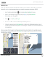
Using the timeline feature
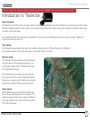
In the top right of Google™ Earth you will
see the timeline pictured here.
Grab the arrows from the center to expand
them. The overall meter represents your route.
The “onion skin” between the two arrows refers
to the length of the animated dots that will
appear when you hit the play button. After
pushing play, the dots will follow the route in
the same nature it was made.
• Pushpins Good for showing each location visited (stopped) by the Trackstick or object being tracked.
Each stop is represented with a pushpin.
TRACKSTICK USER GUIDE
21