1
ROXMAP USER MANUAL
Welcome to RoxMap
The RoxMap Navigational Software programs are designed to display seabed
classification information from RoxAnn®, the world’s leading Seabed Material
Discrimination System.
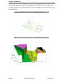
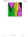
The RoxMap program have been written to display RoxAnn seabed data in up to 32
colours, combine RoxAnn with measured depth data and to display the data in 3
dimensional format.
Navigation functions included in the software program are waypoints, route planning,
instant event marking and measuring functions.
This manual shows the user how to operate all the functions available in your software
program. The RoxMap are Windows™ based and operated by trackerball or mouse,
not relying on keyboard operation.
We hope that you enjoy working with the RoxMap.
ISSUE 0
SSV/ENG/SPEC/076
Page 2 of 39