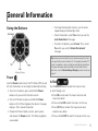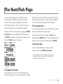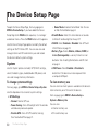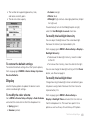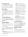
1
DE LORME
Earthmate
®
PN-40/30 GPS
User Manual
GPS for Serious Outdoor Adventures
The Latest and Most Comprehensive
PN-Series Information is Always Online!
User Manuals, Getting Started Info, Tutorials
The DeLorme Wiki is your link to comprehensive information about your Earthmate ® PN-Series GPS. The most recent
User Manual is always available for download. wiki.delorme.com
Community Forum
An open, interactive community of DeLorme product users. DeLorme experts monitor the boards regularly and participate
to answer questions and share their experiences. forum.delorme.com
DeLorme Products and Available Accessories
Our website has product and accessory information, as well as press coverage, contact, and company information.
delorme.com
Technical Support
A large searchable knowledge base of detailed technical information about current and past DeLorme products.
support.delorme.com
News and Real-Life Examples
Catch up with news about what we are working on, real-life examples using PN-Series devices, and more at the DeLorme
Weblog. blog.delorme.com
Batteries
The Earthmate® PN-40 and PN-30 can be powered by two AA
batteries (NiMH, alkaline, or lithium), or a DeLorme-supplied Li-Ion
rechargeable battery. You’ll find Earthmate PN-Series accessories
at www.delorme.com.
Rechargeable Lithium-Ion Battery Pack Caution
Use only an Earthmate PN-Series Battery Type. Risk of explosion
if battery is replaced by an incorrect type. Dispose of used batteries
according to the instructions.
Table of Contents
General Information..........................................................................................................................2
Getting Started.................................................................................................................................7
The Satellites Page.........................................................................................................................10
The Map Page................................................................................................................................ 14
The Compass Page........................................................................................................................23
The Trip Info Page...........................................................................................................................26
The Find Page.................................................................................................................................28
The Waypoints Page......................................................................................................................32
The Geocaches Page.....................................................................................................................37
The Routes Page............................................................................................................................45
The Tracks Page.............................................................................................................................50
The Sun/Moon Page.......................................................................................................................54
The Tide Page.................................................................................................................................56
The Hunt/Fish Page........................................................................................................................58
The Device Setup Page..................................................................................................................59
Additional Information....................................................................................................................65
Info Fields Table..............................................................................................................................73
Index...............................................................................................................................................77
Getting Started
This manual is for use with DeLorme Earthmate ® PN-30
and PN-40 GPS devices; they are referred to as the
"PN-Series GPS" unless otherwise noted.
How to Use this Manual
For more information about the buttons on the PN-Series
GPS, see Using the Buttons on page 5.
When the manual instructs you to do something, use
these actions on the device:
To select an item on the screen, such as a field, check
box, button, drop-down list, menu item, or search
result—use the arrow keypad to move/scroll to the
item to highlight it and press ENTER.
»» To edit alphanumeric fields, use the on-screen
keyboard. See Using the Keyboard on page 7.
»» To edit numeric fields, use the up/down arrows on
the arrow keypad to increase/decrease numbers
and change other information. Use the left/right
arrows to move the selection.
»» To clear a selected check box, press ENTER.
Once you make a selection or finish editing
information, press ENTER to complete the action.
To exit a page or screen, press QUIT.
2
Getting Started
To complete a series of steps—an arrow ( > ) indicates
the sequence. Note that the sequences do not include
ENTER and QUIT button presses described above.
Installing the Batteries and SD Card
You can power your device with two AA batteries (NiMH,
alkaline, or lithium) or a DeLorme rechargeable Lithium-ion
(Li-ion) battery. A slot for an SD card is underneath the
batteries inside the battery compartment.
To install batteries and the SD card
1.Unscrew the D-rings on the back of the device until
you can remove the battery cover.
2.Optional. To insert an SD card, gently press down the
SD card latch, insert the card in the slot, and press
down the slot to close the latch. Note: Do not lift the
SD card latch as this could cause damage.
3.Insert two AA batteries or a DeLorme Li-ion
rechargeable battery according to the polarity symbols
inside the battery compartment. Be sure to insert
batteries correctly.
4.Position the battery cover on the device and screw
in the D-rings.
5.Go to MENU > Device Setup > System > Battery
Type and ensure the correct battery type is selected.
This ensures that the battery indicator displays the
correct amount of battery life remaining.
Note When storing the PN-Series GPS for a month
or longer, remove the batteries.
To view the battery indicator
The battery indicator is on the Satellites Page; for more
information, see Battery Indicator on page 12.
To charge a DeLorme Li-ion battery
To charge a DeLorme Li-ion battery in the device:
1.Install the battery in the device.
2.Connect the device to your computer with the USB
cable. You can leave the device fully powered on.
OR
You can set it to charging mode; with the device
powered off, quickly press Power once. The screen
displays "Charging" or "Charge Complete."
To improve battery life
Automatically turn off the backlight after 15 seconds;
go to MENU > Device Setup > Display > Backlight
Timer > 15 sec.
Use the power saving option; go to MENU > Device
Setup > System > GPS Settings > Power Saving.
Disable the GPS when inside. Go to MENU > Device
Setup > System > GPS Settings > Disable GPS OR
from the Satellites Page, go to MENU > Disable GPS.
Use batteries with higher milliamp-hour (mAh) ratings
(such as Energizer ® Ultimate Lithium).
Turning the PN-Series GPS On or Off
The Power button
is at the bottom right corner
of the button area.
To turn on the device, press and hold Power until you
see the Welcome screen, and then release the button.
To turn off the device, press and hold Power until you
see the "Shutting down the device" message, and
then release the button.
To view or hide Demo Mode
When you first turn on the device, it opens in Demo Mode.
To view the demo, follow the on-screen instructions.
To exit the demo, press QUIT.
To disable Demo Mode—from the first screen, press
ENTER to clear the Show at Startup check box.
To restore Demo Mode, go to MENU > Device Setup
> System > GPS Settings > Demo Mode.
Getting Started
3
Data Management
The PN-Series GPS stores routes and the base map in
its internal memory. Tracks, waypoints, and geocaches
are saved to the SD card in the device. You can save user
maps—including the PN-Series detailed DeLorme Topo
North America™ maps you received on DVDs with your
device—to the device's internal memory or an SD card
(SD/SDHC/MMC).
To view and manage memory information, go to MENU >
Device Setup > System > Memory Use.
Detailed Map Data
Your device comes with a base map showing
overview-level worldwide coverage, as well as North
American interstates and routes, state routes, and major
roads. While this provides a great view of a large area,
you need a detailed view of a smaller area for hiking,
geocaching, and other activities.
You can transfer detailed maps and map packages to
the PN-Series GPS using:
PN-Series detailed map DVDs–Included with
your device are DVDs with detailed pre-formatted
DeLorme Topo North America™ data. This data
includes detailed routable road and topographic data
for the U.S. and Canada and major road data for
4
Getting Started
Mexico. Insert the DVD for your area of interest in
your computer's DVD drive and follow the on-screen
instructions to easily copy the maps onto your device.
Note Elevation data and land cover is not
available for Mexico.
Compatible DeLorme mapping software–
Instructions for sending map packages, data, draw layers,
and more to your PN-Series vary by application. For more
information, see the mapping application’s Help.
Map Library–Use the NetLink tab in your DeLorme
mapping software or the DeLorme Online Map
Center (data.delorme.com) to download many types
of imagery and data, such as satellite imagery, aerial
imagery, USGS Topo Quad maps, NOAA nautical charts,
and more. With an annual Map Library subscription,
you can download unlimited imagery and data for
the entire year—the maps are yours to keep.
Non-DeLorme maps–DeLorme’s professional GIS
software, XMap ®, allows you to register non-DeLorme
maps and transfer them to a PN-Series GPS.
Navionics lake maps and marine charts—Add
fishing maps as well as boating maps and charts
to your device with Navionics SD cards. For more
information, see Navionics on page 21.
General Information
Using the Buttons
»» To change the backlight intensity, use the arrow
keypad to adjust the backlight slider.
»» To lock the buttons, select Yes when you see the
Lock the buttons? message.
»» To unlock the buttons, press Power. Then, select
Yes when you see the Unlock the butons?
message.
Tip Reducing the backlight intensity and decreasing the timer
can significantly improve battery life. The daylight readable TFT
screen is readable in direct sunlight or slanting light conditions.
For more information about backlight intensity and the back
light timer, see the Device Setup > Display section section on
page 61.
Power
Use the Power button to turn the PN-Series GPS on and
off, lock the buttons, or to change the backlight settings.
To turn on the device, press and hold the Power
button until you see the Welcome screen.
To turn off the device, press and hold the Power
button until the "Shutting down the device" message
displays. Then, release the button.
To open the Power Options screen, quickly press
and release the Power button. The following options
are available:
In/Out
Use the IN/OUT button to zoom the map in or out
or scroll through a list.
Press IN once to zoom the map in one level and
show more detail.
Press and hold IN to zoom the map in all the way.
Press OUT once to zoom the map out one level
and show less detail.
Press and hold OUT to zoom the map out all the way.
General Information
5
Press IN or OUT to move forward or backward
a page at a time.
Page
Press the PAGE button to move forward through the
pages in the page order sequence. To add, remove, or
reorder pages, go to MENU > Device Setup > Page
Order (see Page Order on page 64).
The default page sequence is Satellites, Map, Compass,
Trip Info, and Directions (when navigating).
Menu
Press the MENU button to access functions for the page
or screen you are using and pages that are not enabled
in the page order.
The menu's top section lists actions specific to the
active page—select the item and press ENTER.
The bottom section lists the pages you may want
to quickly access at any time.
Find
The Find button is labeled with a magnifying glass. Use
it to search for a point of interest, waypoint, geocache,
address, coordinate, and more. You can search for a
location by name or by its proximity to the current map
center. For more information, see The Find Page section
starting on page 29.
6
General Information
Mark
The Mark button is labeled with a pushpin. Use it to mark
a waypoint at your current GPS location or, when panning,
at the cursor location. Once you mark a waypoint, use its
details page to manage it, view it on the map, or create a
route to it. For more information, see The Waypoints Page
section starting on page 33.
Arrow Keypad
Use the arrow keypad to move around pages and screens.
Press once to move the map cursor left, right, up,
or down in increments.
Press and hold to pan the map.
Highlight options in menus or lists. Press down to
move to the next entry, press up from the first entry
to go to the last entry, or down from the last entry
to go to the first entry.
Highlight fields and highlight characters on the
keyboard screen.
Press and hold to quickly scroll through a menu or list.
On the Map Page, press any arrow once to turn on
the backlight without changing the map view.
Enter
Press the ENTER button to:
Select a menu entry, field, or screen button.
Get information about a point on the map to see
detailed information, if available.
Quit
The function of the QUIT button varies depending on
the status of the PN-Series GPS; some of the things
you can do are:
Exit a page or screen.
Cancel actions (for example, panning).
Close the keyboard and cancel changes.
Delete individual points when measuring distance.
Move backwards through the page order sequence.
Using the Keyboard
The on-screen keyboard is available when you need to
enter text, such as when editing a waypoint label, adding
text to a comment field, or entering search parameters.
Use the arrow keypad to highlight the letter (A–Z),
number (0–9), symbol (+, -, /, &), or punctuation you
want to use, and then press ENTER after each selection.
When you are finished, highlight OK and press ENTER.
For existing text, enter a letter to replace the highlighted
content. To keep the existing text but move the cursor
to the beginning/end of the text, select
to move the
cursor to the beginning or
to move the cursor to the
end of the text.
Special Keys
Move the cursor one space to the left without
deleting a letter or number.
Move the cursor one space to the right without
deleting a letter or number.
Change the case of the next letter (the active case
is shown in the keyboard). To use all caps, highlight
and then press ENTER twice.
Move the cursor one space to the left, deleting
the character that was there.
Move the cursor one space to the right, leaving
a blank space.
Clear the content of the text field being edited.
Accept the changes made to the text field and
close the keyboard.
General Information
7
Insert a line break and move the cursor to
the next line.
Keyboard Shortcuts
These button presses on the PN-Series GPS are
keyboard shortcuts.
IN–Delete the last character
OUT–Add a space
Find–Shift (for upper case)
Mark–Highlight OK
QUIT–Exit the keyboard
View the SD card Contents and open the screenshots
folder. If the SD card is still in the device, go to Device
Setup > Connect to Computer > Open SD Card.
Info Fields
The Map, Compass, and Trip Info Pages include fields
of information that you can customize to suit your needs.
It is easy to go back to the default device settings at any
time. Info fields on other pages cannot be changed.
For more information about what info fields contain,
see the Info Fields Table on page 74.
Rotating the Display
To hide or show info fields
You can choose to allow the screen to rotate when you
turn the device upside down. The keys on the arrow
keypad adjust so that they match the device’s orientation.
If you want the display to rotate, go to Device Setup >
Display > Enable Screen Rotation and select the check
box.
On the Map Page, you can hide info fields for a full-screen
view of the map or show them to get information.
To hide info fields, go to MENU > Info Fields >
Hide Info Fields.
To show hidden info fields, go to MENU >
Info Fields > Show Info Fields.
Note Info fields must show to change, arrange, or
restore them to the default settings.
Taking a Screenshot
To take a screenshot, hold Power and press ENTER.
An SD card must be inserted in the device.
The Screenshots On check box must be selected in
Device Setup > Display. This creates a "screenshots"
folder.
8
General Information
To arrange info fields
On the Map Page and Compass Page, you can change how
info fields look on the screen. You can customize the info
field arrangement differently for tracking and navigating.
Go to MENU > Info Fields > Arrange Info Fields.
To change the size of the text
On the Trip Info Page, you can change the size of the
text that displays, which also changes the number of info
fields. When the device is set to the small text option, it
displays eight info fields (2 wide, 6 narrow)—when it is set
to the large text option, it displays three wide info fields.
Press MENU. The available text size option is preceded
by "Switch to" —highlight the option and press ENTER.
2.Select the info field you want to change and press
ENTER. A list of available info fields opens.
3.Select the new info field and press ENTER.
4.When you finish changing info fields, press QUIT.
To restore info fields
On the Map, Compass, and Trip Info Pages, you can
restore the information fields to their default settings.
This restores which fields show and their arrangement.
From the page, go to MENU > Info Fields >
Restore Default Info Fields.
Units
You can select the units for different types of
measurements that are used on the PN-Series GPS.
To change the units, from any page go to MENU >
Device Setup > Units.
For more information, see Units on page 9.
To change info fields
On the Map Page, Compass Page, and Trip Info Page,
you can customize which info fields display for normal use
and when navigating. To change info fields for navigating,
make the changes while the device is navigating a route.
1.From the page, go to MENU > Info Fields > Change
Info Fields.
Navigating or Tracking
Tracking is the normal state of the device when it has a
GPS fix. You can turn off track recording, but the device
is still in tracking mode. When you follow a route on the
device, you are navigating.
Visit the DeLorme Wiki at wiki.delorme.com for more
information. The latest version of the User Manual is
always available for download.
General Information
9
The Satellites Page
The Satellites Page displays GPS and satellite information,
time, elevation, and the battery indicator.
It is the first page in the default PAGE button order. If you
have removed the Satellites Page from the PAGE button
order, go to MENU > Satellites to view it.
Constellation and Signal Graph
Both the satellite constellation and the satellite signal
graph display visible satellites and their identifying
numbers. The satellite constellation depicts each satellite’s
position in the sky relative to the device’s current position.
10
The Satellites Page
The signal graph bars indicate the strength of each
satellite signal.
The icons in the satellite constellation and the lines in the
signal graph are color-coded based on the quality of the
data they are transmitting:
Red–The receiver is tracking the satellite, but it is not
using it to navigate.
Green–The receiver is tracking the satellite,
ephemeris data is available, and the satellite is being
used for navigation.
Yellow–The receiver is tracking the satellite, predicted
ephemeris data is available when a 3-D fix has not
been obtained, and the satellite is being used for
navigation.
Blue–The receiver is tracking the satellite, ephemeris
data is available, the satellite is being used for
navigation, and WAAS corrections are available.
GPS and WAAS Status
The Global Positioning System (GPS) is a system of
satellites that orbit the earth to provide position and
navigation information. The Wide Area Augmentation
System (WAAS) is system of satellites and ground
stations that correct GPS signals to improve accuracy.
For more information about GPS and WAAS, visit the
DeLorme Wiki (wiki.delorme.com).
The GPS status is based on the satellite acquisition
status:
GPS Off–The GPS receiver is turned off.
No Fix–The GPS cannot find sufficient satellite data to
determine your current GPS position.
2-D–The GPS connection is successful, but the
connection quality is not as good as a 3-D fix.
Move your receiver to another location to get better
reception.
3-D–The GPS is receiving sufficient satellite data
(horizontal position and elevation) to determine your
location.
When the letter W appears below 2-D or 3-D, the PN-Series
GPS has a WAAS connection (available only in North
America) that provides up to five times greater position
accuracy than a regular 2-D or 3-D connection.
To set the current location
If it takes a long time for the PN-Series GPS to obtain
a 2-D or 3-D fix, verify it has a clear view of the sky.
Be sure that trees, buildings, and other obstacles are
not blocking the device.
If the device still cannot obtain a 2-D or 3-D fix, go to
MENU > Set Current Location. When the Map Page
displays; pan the map to your current location and press
ENTER.
If the PN-Series GPS is unable to acquire a fix after
approximately ten minutes, you will be prompted to
disable the GPS or continue searching for satellites.
To disable GPS
You can use many features on the PN-Series GPS
without a GPS fix. When GPS mode is turned off, GPS
OFF displays on the screen and all satellites are removed
from the satellite constellation.
There are two ways to disable the GPS.
From the Satellites Page go to MENU > Disable GPS.
From any page, go to MENU > Device Setup >
System > GPS Settings > Disable GPS.
To turn on GPS mode, follow the same steps and select
Enable GPS.
GPS is temporarily disabled when in simulation mode
(during track playback and navigation simulation).
Time
You can change the time format, time zone, and manually
enable or disable Daylight Saving Time. The time is automatically set from GPS satellites and is highly accurate.
The Satellites Page
11
To change the time settings, go to MENU > Device
Setup > Time.
GPS Accuracy
In the lower left corner of tne Satellites Page, the GPS
accuracy displays. This is the calculated accuracy of the
GPS, expressed in distance. The actual location is within
plus or minus the distance indicated of the location
represented by the GPS.
On the Map Page, GPS accuracy is represented by a
circle with a radius equal to the GPS accuracy; your
actual location on the map is within the circle.
Any buildings, natural structures, or heavy foliage that
obstruct the GPS antenna’s view of the sky may prevent
satellite signals from reaching the receiver and decrease
the accuracy of your position. Placing the PN-Series GPS
in a jacket or backpack pocket should not affect positional
accuracy.
Battery Indicator
The battery indicator depicts the available battery power:
Four green bars–Indicates a full charge.
Three green bars–One quarter of the battery power
has been used.
Two yellow bars–One half of the battery power has
been used.
12
The Satellites Page
One red bar–Three quarters of the battery power has
been used. Once the battery has reached 5% of its
total battery power, a low battery warning displays.
When a DeLorme Li-ion battery is charging, the battery
indicator graphic is animated and the word “Battery”
is replaced with “Charging.” Once the battery is fully
charged, the battery indicator graphic displays four static
green bars and “External” displays until you disconnect
the USB cable.
If you are not using the DeLorme Li-ion battery, "External"
displays whenever you plug your device into your computer.
Elevation
PN-40 Only
The elevation is based on the current barometric altimeter
reading. When the Auto Calibrate Altimeter option is
enabled, you may see the word “Calibrating” in the bottom
right corner of the screen while the altimeter adjusts—
typically 2-3 minutes. If you are using the Elevation:
Altimeter info field on any page, you may see a red
exclamation point in the field while the altimeter adjusts.
For more information about calibrating the altimeter,
see Altimeter Calibration on page 68.
Compass and Altimeter
PN-40 Only
You can calibrate the PN-Series GPS's electronic compass
and barometric altimeter with the Calibrate option on the
Satellite Page menu, the Compass Page menu, and the
Device Setup > Compass & Altimeter menu. The Device
Setup > Compass & Altimeter options allow you
to disable/enable the electronic compass, the barometric
altimeter, and the auto-calibrate altimeter option. For
more information, see Compass and Altimeter starting
on page 67.
Visit the DeLorme Wiki at wiki.delorme.com for more
information. The latest version of the User Manual is
always available for download.
The Satellites Page
13
The Map Page
The Map Page centers the map on your current location
when the PN-Series GPS has a 2-D or 3-D fix. When it
does not have a GPS fix, the map displays your last GPS
position. For more information, see GPS and WAAS
Status on page 10.
The Map Page is the second page in the default PAGE
button order.
and the arrow points in the direction of the last
known heading.
Flashing red–The device cannot obtain a GPS signal
and is not tracking satellites.
Blue–The device is in Track Playback mode or
Simulate Navigation mode.
Yellow–The device has a 2-D fix and predicted
ephemeris data is available.
Green–The device has a 3-D fix.
Tracking
When tracking satellites, a track line—also known as
a breadcrumb trail—follows the GPS arrow as you move.
If you have turned off track recording, the track does not
appear. For more information, see The Tracks Page
section starting on page 51.
Scale and Orientation
GPS Arrow
The GPS arrow displays on the map when GPS is enabled.
The color of the GPS arrow depends on your GPS signal
14
The Map Page
For information about:
Setting the scale, see Scale on page 20.
Map orientation, see Orientation on page 19.
Panning the Map
There are two ways to pan the map. When you pan the
map, the map cursor—a white arrow—shows your location.
Automatic panning– When GPS tracking or
navigating, the map automatically pans in the direction
of travel. The map does not automatically pan when
the map cursor is visible. Press QUIT to remove the
map cursor and return to automatic panning.
Manual panning–To manually pan the map, use
the arrow keypad to move the cursor in the direction
you want to view.
»» Use single presses to move the cursor in
increments.
»» Press and hold to quickly pan to a new location.
»» Hold the cursor at the edge of the screen to keep
panning in that direction; the map will move to the
new location.
»» Press QUIT to center the map on your
current location.
As you pan, a text field at the top of the map displays
information about the cursor location. When you stop the
cursor over an object, the field in the bottom left corner
displays the object name.
Getting Location Information
For information about objects at your current GPS
location, press ENTER.
OR
Pan the map to a new location. When you stop the cursor
over an object, its name is displayed in the bottom left
corner of the map. Press ENTER.
For single objects, the object details page displays.
Mark a waypoint, view it on the map, or route to it.
For multiple objects, the Multiple Objects screen
displays a list of the objects at that location; user-created
objects (such as waypoints) appear at the top of the
list. Select an object and then press ENTER to view
its details page.
The Map Page
15
Info Fields
You can hide/show, change, and arrange the info fields
at the bottom of the Map Page. The info fields change
when you are navigating. To access the Info Fields
options, go to MENU > Info Fields. For more information,
see Info Fields on page 8.
the total distance from the last measurement node to
the first measurement node. Once you close a polygon,
it displays the area.
You can also measure area using a track. See Calculating
the Area of a Track on page 54.
Measure Distance and Area
Use the measurement tool to measure the distance of
a line or the perimeter and area of a polygon on the map.
To measure distance
From the Map Page, go to MENU > Measure Distance.
Use the arrow keypad to move the cursor to the area
on the map where you want to place the first point of
the line or polygon and press ENTER to place the first
point. Repeat for each point.
To undo a point, press QUIT.
To make a polygon, you must close the shape. Place
the last point on top of the first point by hovering the
cursor over the start location and pressing ENTER to
snap the point and close the polygon.
While you are measuring distance, the pan location information that displays in the top right corner of the screen
changes to display the heading from the last measurement
node to your current GPS location, the leg distance, and
16
The Map Page
Map Setup
Use the Map Setup page to customize the map. You
can change the order of data layers; show or hide maps
and imagery; choose map orientation and scale; and
determine how various information displays on the map.
From the Map Page, go to MENU > Map Setup.
Data Layering
The pre-installed base map on the device shows
high-level world coverage, as well as more detailed North
American coverage. You can add maps, data, imagery,
draw files, and more to your device to supplement the
base map. When you add different types of maps to
the same area, you can customize the order in which
the layers appear.
For more information about the types of data you can add
to your PN-Series GPS, see Detailed Map Data on
page 4.
To manage individual map packages that you have added
to your device, see Data Management.
Only the data types you have on your device show in the
Data Layering list. The default order for layering data is:
GIS layers by name (XMap ® only)
Draw Layers
Public Lands
User Raster Data (XMap only)
Custom Raster Data (XMap only)
ImageReg (XMap only)
Digital Globe 30cm (DG 30cm)
High-resolution City Imagery (Hi-Res Cities)
Digital Globe 60cm (DG 60cm)
Digital Globe 1m (DG 1m)
Color Aerial Imagery (Color DOQQ)
Aerial Imagery (DOQQ)
USGS Quads (3DTQ)
Canadian 1:50K Topographic Sheets (Canadian 1:50K)
NOAA Nautical Charts (NOAA Charts)
Satellite Imagery (SAT10)
XMap Topographic Data (XMap only)
DeLorme Topographic Data (Topo North America 9.0)
DeLorme World Base Map 7 (XMap only)
To layer data
Use the Data Layering option to select the types of data
you want to view on your PN-Series GPS and the order
in which you want data to display.
From the Map Page, go to MENU > Map Setup > Data
Layering to view a list of all the types of data you have
stored on your device's internal memory or on an SD card
in the device; this may include data that is not available for
the area you are viewing. When you highlight an item, the
full name of the data type shows in the box at the bottom
of the screen.
To show a type of data, select the check box next to it.
To hide a type of data, clear the check box next to it.
To change the order in which data is layered, highlight
the item you want to move, then use the arrows on the
right side of the screen to move the item up or down
in the list. If two data types have identical zoom level
settings, the one higher in the list has precedence.
To select/deselect all check boxes, go to MENU >
Select All or MENU > Deselect All.
The Map Page
17
To reset the default layer settings (all check boxes
selected and data ordered as in the list above), go to
MENU > Restore Layer Defaults.
Data Management
After you add a map—also called a map package or a map
file—from a compatible DeLorme mapping program or
the DeLorme Online Map Center to the PN-Series GPS,
you can show or hide it on the device; view details about
it, including where it is stored; or delete it. To change the
priority of how different types of map data are displayed,
see the previous section—Data Layering.
For more information about the types of data you can add
to your device, see Detailed Map Data on page 4.
it and go to MENU > View Map.
To view details for a map package, highlight it and
go to MENU > Data Detail. This displays the name,
data types, zoom level, scale information, save date,
location (internal or SD card), and version information.
To delete a map package, highlight it and go to
MENU > Data Detail > Delete.
To manage maps and data
From the Map Page, go to MENU > Map Setup > Data
Management to view a list of the map packages you
have stored in your device's internal memory or on an SD
card in the device. When you highlight an item, the type
of data and location shows at the bottom of the screen.
To show the map package, select its check box.
To hide the map package, clear its check box.
To select/deselect all check boxes, go to MENU >
Select All or MENU > Deselect All.
To view the map package on your device, highlight
18
The Map Page
Turn Imagery On/Off
When you have added map packages that include
imagery to your PN-Series GPS, you can quickly turn
the imagery off or on.
From the Map Page, go to MENU > Turn Imagery On
or Turn Imagery Off.
Orientation
You can set the map to rotate as you move.
Arrow displays in the top right corner of the map
screen when navigating.
If you want Heading Up or Course Up to automatically
switch to North Up above the specified scale (depends
on the units of measure you have set), select the North
Up above... scale check box.
Map Style
Topo View displays all topographic data as it was saved
in the map package; this is the default view. Street View
hides the contours and land cover for a clean road map
that is easier to view when driving.
To change the map orientation
From the Map Page, go to MENU > Map Setup >
Orientation and select the map orientation from
the drop-down list.
North Up–North is always at the top of the
map screen.
Heading Up–The direction in which you are traveling
is always at the top of the map screen. The North
Arrow displays in the top right corner of the map
screen.
Course Up–The direction of the finish of your route
is always at the top of the map screen. The North
To change the map style, from the Map Page go to
MENU > Map Setup > Map Style and select Topo View
or Street View from the drop-down list.
Hybrid Map
You can show points, lines, and labels on top of imagery.
Hybrid maps are visible at scales of 640 feet and higher.
From the Map Page, go to MENU > Map Setup > Map
Style > Show Hybrid Map and select the check box.
Map Point Management
Customize how points of interest (POIs), waypoints,
and geocaches display on the map.
From the Map Page, go to MENU > Map Setup > Map
The Map Page
19
Point Management. Use the drop-down list for each
option to select how you want it to appear on the map.
To hide logged geocaches, select the Hide Logged
Caches check box.
the scale doubles.
Ratio–Shows a ratio of a unit on the device compared
to the actual unit.
Scale
The scale option lets you set the type of scale you want
to use on your maps.
Other Menu Options
When navigating or viewing a route on the map, additional
options are available on the Map Page menu.
View Comment Details
To set the scale
From the Map Page, go to MENU > Map Setup > Scale
and select an option.
Bar–Represents a given length on the map compared
to an actual length.
Zoom–The DeLorme method of describing map
detail level. Each time the zoom level increases,
20
The Map Page
When navigating, go to MENU > View Comment Details
to quickly view the comment for the waypoint, geocache,
or point you are navigating to. The comment for the most
recently viewed point is displayed.
Log Your Geocache Find
When navigating to a geocache, use the Log Your
Geocache Find option to quickly log geocaches, write field
notes, and pick your next cache. For more information
about all of these features, see The Geocaches Page
section starting on page 38.
Route Options
When navigating, use Route Options to stop navigating,
get back on track, or switch the route type. For more
information about route options, see Edit Route Settings
on page 46.
Go to MENU > Route Options and select Stop
Navigating, Back on Track, or Switch to Hiking/
Driving (the option you can switch to displays).
Hide Route
When you are viewing a route on the map, you can hide it.
Go to MENU > Hide Route.
The Map Page
21
Navionics
You can use Navionics HotMaps Premium Lake Maps
and GOLD+ Marine Charts with your PN-Series GPS.
The charts are available on SD cards that you insert into
your device. For more information about the charts that
are available, visit navionics.com.
®
General Information
Navionics information appears on the device only
when have a Navionics SD card in your device.
You cannot save maps or data to a Navionics SD
card—the memory on the card is unavailable.
The Navionics data overlays the DeLorme maps
on device—the DeLorme maps are used for
routing and Find.
Tracks, routes, waypoints, and geocaches display over
the Navionics charts.
When you pan the map and select an object (other
than those listed above) with the map cursor,
Navionics information is displayed.
Turn Charts On/Off
You can quickly turn Navionics charts on or off. The
Navionics chart closest to the map center automatically
displays.
From the Map Page, go to MENU > Turn Charts On
22
The Map Page
or Turn Charts Off.
Note This menu option controls the Show Charts and Show
Boundaries check boxes on the Navionics Setup page.
Navionics Setup
Customize the way Navionics charts appear on your
PN-Series GPS. To access all of these options, go to
MENU > Map Setup > Navionics Setup.
To select a chart
Select the chart or map you want to view—the contents
of the SD card are listed in the Charts drop-down list.
From the Navionics Setup page, go to select the chart
or map you want to use from the Chart drop-down list.
To view a chart or map
To view the chart or map selected in the Chart drop-down
list on the device, click View Chart.
To show charts or boundaries
Control how you view charts and their boundaries
on the map—view charts alone, boundaries alone,
or both together.
To show charts, select the Show Charts check box.
To show boundaries, select the Show Boundaries
check box.
To hide charts by map scale
To show the depth in fathoms
You can customize at which map scale you can view
charts on the device.
If you want to show chart depths in fathoms instead
of feet or meters, select the Show Depth in Fathoms
check box.
From the Hide Charts check box, select the scale above
which you want to hide the charts.
To set chart details
To change the detail level of your charts, select High
or Low from the Chart Details drop-down list.
To show or hide contours
You can show all contours or select a level above which
to view them.
From the Hide Contours drop-down list, select the
option you want to use.
To set the safety depth
To restore the default settings
To restore the default Navionics Setup settings, select
Restore Defaults.
Tip On marine charts, select the Port Services symbol (pink
ship) to view a list of services available at the location. You
must zoom in to 640 ft/200 m to view the symbol.
Visit the DeLorme Wiki at wiki.delorme.com for more
information. The latest version of the User Manual is
always available for download.
Set the safety depth or turn it off.
From the Safety Depth drop-down list, select the option
you want to use.
To set the presentation mode
US and International charts have different symbols and
markings. You can set the way you want this information
to display.
From the Presentation Mode drop-down list, select
US or International.
23
The Compass Page
Use the Compass Page’s graphic compass to help you
find your destination. Both the PN-40 and the PN-30
use the GPS to determine compass readings when the
device is moving. The PN-40 also has an electronic
compass for use when the device is stationary or
moving below 1.5 mph.
The Compass Page is the third page in the default PAGE
button order. If you have removed the Compass Page
from the PAGE button order, go to MENU > Compass
to view it.
Bearing Arrow
On the Compass Page, the compass rotates so that the
heading is always up. When you are navigating a route,
a bearing arrow displays on the compass and the info
fields update.
To change the Hiking Route Arrow
When you are navigating a hiking (direct) route, you
can choose to have the bearing arrow point to the next
waypoint in your route or point back on course if you leave
the route. To set the hiking route arrow method; from
the Routes Page, go to MENU > Edit Route Settings >
24
The Compass Page
Compass Navigation Arrow.
To change the hiking route arrow from the Compass Page,
go to MENU > Compass Navigation Arrow > Direct to
Next Waypoint or Back on Course.
you are in an area with magnetic interference. You should
also calibrate the compass when you change batteries.
For more information, see Compass and Altimeter
starting on page 67.
Info Fields
Calibrating Sensors
You can hide/show, change, and arrange the info fields
at the bottom of the Compass Page. The info fields
change once you start navigating a route. To access the
Info Fields options, go to MENU > Info Fields. For more
information, see Info Fields on page 8.
PN-40 Only
Electronic Compass
PN-40 Only
The PN-40 has an electronic compass that shows your
direction when you are stationary or almost motionless.
When your speed is 1.5 mph or higher, the compass
reading is based on the GPS.
When the electronic compass reading is not accurate,
“Poor Accuracy” displays in the bottom right corner of
the screen, and a red exclamation point appears in the
Heading info field. When you see this indicator, you may
want to calibrate the compass unless you know the
inaccuracy is caused by a temporary event, such as being
near power lines or near a magnetic field caused by a car.
You may want to disable the electronic compass when
You can calibrate the PN-40's electronic compass and
barometric altimeter with the Calibrate option on the
Satellite Page menu, the Compass Page menu, and the
Device Setup > Compass & Altimeter menu. The Device
Setup > Compass & Altimeter options allow you to
disable/enable the electronic compass, the barometric
altimeter, and the auto-calibrate altimeter option.
For more information, see Compass and Altimeter
starting on page 67.
Other Menu Options
When navigating, additional options are available on
the Compass Page menu.
View Comment Details
When navigating, go to MENU > View Comment
Details to quickly view the comment for the waypoint
or geocache you are navigating to. The comment for the
most recently viewed point is displayed.
The Compass Page
25
Log Your Geocache Find
When navigating to a geocache, use the Log Your
Geocache Find option to quickly log geocaches, write field
notes, and pick your next cache. For more information
about all of these features, see The Geocaches Page
section starting on page 38.
Route Options
When navigating, use Route Options to stop navigating,
get back on track, or switch the route type. For more
information about route options, see Edit Route Settings
on page 46.
Go to MENU > Route Options and select Stop
Navigating, Back on Track, or Switch to Hiking/
Driving (the option you can switch to displays).
Visit the DeLorme Wiki at wiki.delorme.com for more
information. The latest version of the User Manual is always
available for download.
26
The Compass Page
The Trip Info Page
The Trip Info Page displays info fields that occupy the
entire screen. You can customize each field with one
of the many available info field options.
It is the fourth page in the default PAGE button order.
If you have removed the Trip Info Page from the PAGE
button order, go to MENU > Trip Info to view it.
Info Fields
You can hide/show, change, and arrange the info fields.
You can also use the large text option, which displays in
three horizontal info fields. The info fields change when
you are navigating. For more information, see the
Info Fields section beginning on page 8.
For descriptions of all the info fields, see the Info Fields
Table section beginning on page 74.
To reset the trip information
Use the Reset Trip Info option to start a new trip and reset
the trip values (trip odometer, time moving, time stopped,
and time total), speed information (average, maximum,
and moving average), elevation (maximum and minimum),
and the device odometer. Track recording is not reset. If
you want to keep track of all your travels on your device,
clear the Device Odometer check box before you reset
your information.
1.From the Trip Info Page, go to MENU > Reset Trip
Info.
»» To reset an option, select the check box next to it.
»» To exclude an option from being reset, clear the
check box next to it.
2.Select Reset Now.
The Trip Info Page
27
Other Menu Options
When navigating, additional options are available
on the Trip Info Page menu.
View Comment Details
When navigating, the View Comment Details option
allows you to view any available comments for the
geocache or waypoint you are navigating to. The
comments for the most recently viewed point display.
Log Your Geocache Find
When navigating to a geocache, use the Log Your
Geocache Find option to quickly log geocaches, write
field notes, and pick your next cache. For more information
about all of these features, see The Geocaches Page
section starting on page 38.
Route Options
When navigating, use Route Options to stop navigating,
get back on track, or switch the route type. For more
information about route options, see Edit Route Settings
on page 46.
Go to MENU > Route Options and select Stop
Navigating, Back on Track, or Switch to Hiking/
Driving (the option you can switch to displays).
28
The Trip Info Page
Visit the DeLorme Wiki at wiki.delorme.com for more
information. The latest version of the User Manual is
always available for download.
The Find Page
Use the Find Page to search for addresses, roads,
cities, points of interest (POIs), waypoints, geocaches,
coordinates, and more on your PN-Series GPS.
To open the Find Page, press the Find button
.
Search Methods
There are two Find search options. The most recent
search method you use is saved between searches.
Find Near Map Center–This is the default search
method. The device searches from the current GPS
location; if GPS is disabled or if you are panning the
map or viewing another location, it searches from the
current map center. The search continues until the
maximum number of search results (100) is found.
Find by Name–Use this option to search for a
specific location by its name. Results are listed
alphabetically.
Narrow a Name search with the Name Contains
or Name Begins with options—press MENU to
access them.
»» Name Begins With–In the Name field, type one
or more letters that the name begins with; the more
letters you enter, the more relevant your results are.
»» Name Contains–In the Name field, type one or more
characters that the name contains; the more characters
you enter, the more relevant your results are.
For some search types, you can also narrow your
search with additional parameters, such as categories
or symbols.
When the City, State, or Country fields are available,
the more information you enter, the more refined your
search results are. If you do not enter anything or if
those fields are unavailable, the search starts from
the map center.
The Find Page
29
To clear all fields into which you have entered
information, go to MENU > Clear All Fields.
To view the search method you are using
Go to Find > MENU. The available options are preceded
by "Switch to..." and the device is set to the option that is
not showing. To change the search method, select
the method you want to use.
Searching for a Location
To search for a location, press Find at any time.
The search begins, using the current search criteria.
You can change the search method.
You can use additional search parameters, when
available, to narrow your search.
"Searching >>>" displays as the device searches
for locations.
At any time, press the arrow keypad to stop
the search process.
If the search process is stopped, select Continue
Search to keep searching.
Show
The Show field is the primary search category. You can
select the following Show options; below each option
is a list of information you can change to improve your
30
The Find Page
search results:
All
State/Country/City/Name (Find by Name only)
Recent Finds–Shows the ten most recent
search results.
Draw Layers (appears only if you have draw layers
on the device)
Name (Find by Name only)
GIS Layers (appears only if you have GIS layers
on the device)
Name (Find by Name only)
Waypoints (from the current file)
Symbol
Name (Find by Name only)
Geocaches (from the current file)
Symbol
Name (Find by Name only)
Points of Interest
Category
State/Country/City/Name (Find by Name only)
Natural Features
Category
State/Country/City/Name (Find by Name only)
DeLorme Atlas & Gazetteer Points
Category
State/Country/City/Name (Find by Name only)
Addresses
State/Country/City/Building Number/Street Name
(Find by Name only)
Coordinates
Coordinates can be edited.
Streets/Trails
State/Country/City/Name (Find by Name only)
Cities
State/Country/Name (Find by Name only)
Search Results
Search results are displayed in a list. When you highlight
an item in the list, the Bearing and Distance info fields
display measurements as follows:
From the GPS position when the device has a GPS fix.
From the cursor location if you are manually panning
or viewing another location.
From the map center if the GPS receiver is turned off.
To view the results list
To view the results, use the arrow keypad to scroll
through the list. The maximum number of results for each
search is 100.
To view search result details
To view the details for an item on the list, select it.
The search result details page displays.
To edit/change search fields
When a field is highlighted, you can edit or change it.
To edit a field, press ENTER and use the available option
(drop-down list, arrow keypad, or keyboard) to make
changes. When you are finished editing, press ENTER.
The Find Page
31
To mark a waypoint for a search result
On the search result details page, select Mark. The result
is saved as a waypoint and the waypoint details page displays;
you can edit the information. For more information see
To edit waypoint details on page 36.
To view/center a search result on the map
On the search result, waypoint, or geocache details page,
select View. The Map Page displays and is centered on
the search result. Press QUIT to return to the details page.
To create a route to a search result
You can navigate directly to the search result from your
current location. For more information about creating and
modifying routes, see The Routes Page starting on page 46.
1.On the details page for the search result, select Route.
2.On the route details page, select Navigate.
Note When you are creating a route from a geocache
details page, go to step 3.
3.Select Hike or Drive.
The route calculates and the Map Page opens in
navigation mode.
Visit the DeLorme Wiki at wiki.delorme.com for more
information. The latest version of the User Manual is
always available for download.
32
The Find Page
The Waypoints Page
A waypoint is a location that you mark and store using
the PN-Series GPS. You can also transfer waypoint files
to an SD card in the device. Waypoints are identified by
coordinates, and you can assign a symbol, name, and
other information to them. The Waypoints Page lets you
view a list of the active waypoints on your PN-Series
GPS. Waypoints are active when you:
Open a waypoint file
Mark a new waypoint
For information about geocache waypoints, see
The Geocaches Page section starting on page 38.
Managing Waypoint Files
XMap 7 users See the supplemental online help on the
DeLorme Wiki (pn40.wiki.delorme.com/xmap) for information
about using XMap with the Waypoints Page.
To open the Waypoints Page, from any page go to MENU
> Waypoints. If you have added the Waypoints Page to
the PAGE button order, it is no longer available on menus.
Press the PAGE button until it appears.
Waypoints are managed using GPX files with an SD card
in your device; each file can contain up to 1,000 waypoints.
For more information about GPX files, see File Management
starting on page 66.
Tip Use Find to quickly locate a waypoint in the open waypoint
file. For more information, see The Find Page section starting
on page 29.
Waypoint List
The Waypoints Page displays a list of waypoints from the
The Waypoints Page
33
GPX file open on your device. The file name and the number
of waypoints in the file appear at the top of the page.
When you highlight a waypoint in the list, the Bearing and
Distance info fields display measurements as follows:
From the GPS position when the device has a GPS fix.
From the cursor location if you are manually panning
the map.
From the map center if the GPS receiver is turned off.
Sorting the List
There are two ways to sort your list of waypoints—
by distance from your GPS location or alphabetically by
name. From the Waypoints Page, press MENU; the
device is set to the option that is not showing. To switch
to the highlighted option, press ENTER. If the file has a
large number of waypoints, press ENTER to interrupt
the sorting process and see a partial list.
Symbols
The waypoint symbols available on the PN-Series GPS
match the PN-Series symbol set in your DeLorme mapping
application. The symbol set includes geocaching symbols
(these are at the end of the symbol list). To ensure a
waypoint displays on the Waypoints Page, use a waypoint
symbol. If you use a geocaching symbol, the waypoint
will display only on the Geocaches Page. To see the
34
The Waypoints Page
geocaching symbols, go to page 39. For a complete list
of symbols, see the DeLorme Wiki (wiki.delorme.com).
File Menu
Use the File menu to manage waypoint GPX files stored
on the SD card in the device, as well as waypoints you
create on the device. For more information about files,
see File Management on page 66.
To open the File menu, from the Waypoints Page, go
to MENU > File. The following options are available:
New–Create a new GPX file and name it. When you
turn off the device, the file will automatically be saved.
Open–View a list of files on the SD card. Select the
file you want to open and press ENTER to view the
waypoints on the device.
Save As–Save the open file as a new file and name
it. If you have made any changes to the open file, the
changes are saved in the new file—the original file
does not retain the changes.
Close–Close the open GPX file.
Marking a Waypoint
Use the Mark button on the PN-Series GPS to mark a
waypoint at your current GPS location or at the map cursor
if you are viewing another location on the map. When
the waypoint is marked at the map cursor location, the
elevation is not available. When you press Mark, the
waypoint is saved and a waypoint details page opens
where you can edit the waypoint details. For more
information, see To edit waypoint details on page 36.
When you mark a waypoint from a details page, such as
a Find search result or a map object, the device uses the
information available for the symbol and name. If no
information is available, the red map pin is the
default symbol.
To mark a waypoint on the map
You can also mark waypoints using the on-screen Mark
option on Find search result details and route point
details pages.
When you mark a waypoint, the default waypoint symbol
is a red map pin and the label is "Wpt 001." When you
change the symbol or label, each new waypoint uses that
format until you change either the symbol or the name.
When you add multiple waypoints with the same name,
a sequential number is added to the name. For example,
if you name a waypoint “Campsite,” the second waypoint
is named “Campsite 002” and so on.
From the Map Page, press Mark to save the waypoint
to the current waypoint file. If a waypoint file is not open,
a new file opens and your are prompted to name and
save the file.
Once the waypoint is saved, the waypoint details
page opens. On the waypoint details page, you can do
the following:
Edit the waypoint details.
Delete the waypoint.
View the waypoint on the map. To return to the
waypoint details page, press QUIT.
Create a route to the waypoint.
For more information, see Managing Waypoints.
To mark a waypoint from a search result
or route point
On a Find search result details page or a route point details
page, select Mark on the screen. The result is saved as
a waypoint and the waypoint details page displays; you
can edit the information.
The Waypoints Page
35
Managing Waypoints
To view waypoint details
Use the waypoint details page to view detailed
information a waypoint.
From the Waypoints Page, select a waypoint and
press ENTER. The waypoint details page opens.
To edit waypoint details
On a waypoint details page, you can customize the
waypoint symbol, label (name), coordinates, elevation,
time/date, and comments.
To edit a field, use the arrow keypad to highlight it and
press ENTER. Use the available option (drop-down list,
arrow keypad, or keyboard) to make changes. When you
are finished editing, press ENTER.
To view comment details
From the waypoint details page, go to MENU >
View Comment Details.
Note When navigating, the View Comment Details
option is also available from the Map, Compass, Trip Info,
and Directions pages. The comment for the most recently
viewed point is displayed.
To view/center a waypoint on the map
From the waypoint details page, select View; press QUIT
to return to the waypoint details page.
36
The Waypoints Page
To move the waypoint to the current
GPS location
From the waypoint details page, go to MENU >
Move to GPS Location. When you see the confirmation
message, select Yes.
To create a route to a waypoint
You can navigate to waypoint from your current location.
All driving routes and hiking routes with multiple points
are automatically saved. For more information about
creating and modifying routes, see The Routes Page
starting on page 46.
1.On the waypoint details page, select Route.
2.On the route details page, select Navigate.
3.Select Hike or Drive.
The Map Page opens in navigation mode.
To delete a waypoint
From the waypoint details page, go to MENU > Delete
Waypoint. When you see the confirmation message,
select Yes.
To delete waypoints by symbol
1.From the Waypoints Page, go to MENU >
Delete by Symbol.
2.On the Waypoint Symbols page, select the check box
for each symbol you want to delete. Only symbols
used in the current file are listed.
3.Select Delete. When you see the confirmation
message, select Yes.
The waypoints with that symbol in the current file
are deleted from the file.
Averaging a Waypoint
When you average a waypoint, the PN-Series GPS
records a series of GPS readings for the waypoint’s
location and averages them to increase the positional
accuracy of the waypoint. As you average the waypoint,
the GPS status, coordinates, elevation, number of readings
at the location, and estimated accuracy display. Multiple
readings improve the positional accuracy of the waypoint.
The estimated accuracy number decreases as the
accuracy improves.
Projecting a Waypoint
You can project a waypoint at a new location by providing
the bearing and distance from an existing waypoint.
To project a waypoint
1.From the waypoint details page, go to MENU >
Project Waypoint.
2.Enter the information for the projected waypoint in
the Bearing and Distance fields.
3.Select Move to move the existing waypoint to
Create New to mark a new waypoint at the
projected location. Then, press ENTER.
Visit the DeLorme Wiki at wiki.delorme.com for more
information. The latest version of the User Manual is
always available for download.
To average a waypoint
From the waypoint details page, go to MENU > Average
Waypoint. When the device has recorded the number
of readings you want, press ENTER.
Tip Average your location during multiple visits, at different
times of the day to get the best results. Always place the
device in the same location to average the waypoint.
The Waypoints Page
37
The Geocaches Page
Geocaching is a treasure hunting game where you use
a GPS device to search for geocaches—containers that
include a log for you to record your visit. Some geocaches
have trinkets you can take—just follow the “take one,
leave one” rule. To find out more about geocaching,
visit Geocaching.com.
On a PN-Series GPS, a geocache is a special type of
waypoint used for geocaching. The Geocaches Page lets
you view a list of the active geocaches on your device.
Geocaches are active on your device when you open
a waypoint file that contains geocaches.
You can also use the Find button to search for geocaches;
for more information see The Find Page section starting
on page 29.
To open the Geocaches Page, from any page go to MENU
> Geocaches. If you have added the Geocaches Page to
the PAGE button order, it is no longer available on menus.
Press the PAGE button until it appears.
38
The Geocaches Page
Managing Geocache Files
Geocaches are managed using waypoint GPX files on an
SD card in your device; each file can contain up to 1,000
geocaches and child waypoints. For more information
about GPX files, see File Management on page 66.
Geocache List
The Geocaches Page displays a list of active waypoints
from the GPX file open on your device. The file name and
the number of geocaches and any child waypoints in the
file appear at the top of the page. When you highlight
a waypoint in the list, the Bearing and Distance info fields
display measurements as follows:
From the GPS position when the device has a GPS fix.
From the cursor location if you are manually panning
the map.
From the map center if the GPS receiver is turned off.
For example, if you choose a waypoint symbol, the
geocache will move to the Waypoints Page and if you
change a symbol from a not logged to a logged symbol
type, it will move from the Show Not Logged to the
Show Logged list.
Sorting the List
The Geocaches Page is automatically sorted into two
separate lists—logged and not logged—based on the
geocaching symbol type. You can sort the list you are
viewing by the distance from your GPS or map location
or sort alphabetically by name.
The device is set by default to sort by name. To change
the sorting method, press MENU, highlight the sorting
method to use and press ENTER. If the file has a large
number of geocaches, press ENTER to interrupt the
Sorting Geocaches process and see a partial list.
Symbols
Geocache symbols come from Geocaching.com and are
also available in the PN-Series symbol set in your DeLorme
mapping application. For a printable list of symbols on the
device, see the DeLorme Wiki (wiki.delorme.com).
When you change a geocache symbol, be aware that it
may affect how the geocache is displayed on the device.
File Menu
Use the File menu to manage geocache (waypoint) GPX
files on an SD card in the device, as well as geocaches
you create on the device. To open the File menu, from
the Geocaches Page, go to MENU > File. The following
options are available:
New–Create a new GPX file and name it. When you
turn off the device, the file will be automatically saved.
Open–View a list of GPX files on the SD card. Select
The Geocaches Page
39
the file you want to open and press ENTER to view
the waypoints on the device.
Save As–Save the open file as a new file and name
it. If you have made any changes to the open file, the
changes are saved in the new file—the original file
does not retain the changes.
Close–Close the open GPX file.
How to Add Geocaches to
the Device
Use one of the following methods to send geocaches
to your device.
DeLorme Topo North America™ 9.0–Use
Earthmate ® GPS Sync to sync GPX files, including
Pocket Queries from Geocaching.com, and then
send them to your device. See the program's Help
for more information.
DeLorme Send to GPS Plugin–This free plugin is
available to members of Geocaching.com. Once you
find a geocache on the Geocaching.com website,
send it directly to your device. See To use the Send
to GPS plugin.
DeLorme Cache Register™–Cache Register is a
desktop computer utility you can use to send pocket
queries (groups of geocaches) from Geocaching.com
to a PN-Series GPS. You must be a premium member
40
The Geocaches Page
of Geocaching.com to create pocket queries.
To purchase Cache Register, visit our website
(delorme.com). See the program's Help for more
information on how to use Cache Register.
Note Cache Register is compatible with Apple ®
computers.
To use the Send to GPS plugin
With the DeLorme Send to GPS plugin, you can send
one geocache at a time to a PN-Series GPS. You must be
logged in to Geocaching.com to use this feature. Please
note that geocache descriptions and hints are available
only for premium members of Geocaching.com.
1.Connect your device to your computer. The device
should be set to the default Connect to Computer
setting—Use GPS.
2.On Geocaching.com, use the Seek a Cache feature
to find the geocaches in your area of interest.
3.From the results list, click the Send to GPS icon or
view the geocache’s details and click the Send to
GPS button.
4.The DeLorme Send to GPS plugin opens and transfers
the geocache to your device.
5.Repeat step 3 to send each geocache to your device.
Managing Geocaches
To view geocache details
Use the geocache details page to view information about
a geocache, when available.
From the Geocaches Page, select a geocache and press
ENTER. The geocache details page opens.
To edit a field, select it and press ENTER and use
the available option (drop-down list, arrow keypad, or
keyboard) to make changes. When you are finished
editing, press ENTER.
To view comment details
Comment details give you detailed information about the
geocache, such as the cache ID, the size, the difficulty
and terrain, as well as the full description, the hint, and
the full log. Note .loc files do not include comments.
From the geocache details page, go to MENU > View
Comment Details.
Note When navigating to a waypoint or geocache, the
View Comment Details option is also available from the
Map, Compass, Trip Info, and Directions pages. The
comment for the most recently viewed point is displayed.
Tip The Last Logged field on the geocache details page
displays the first two lines of the most recent log entry.
To edit geocache details
You can edit the symbol, label, and coordinates. You can
edit comment details for geocaches you have created
on the device. Changes you make to the geocache
details on your device do not update information on
the Geocaching.com website.
The Geocaches Page
41
Tip Press the Out button to move through the comment one
page at a time. Press the Up arrow on the arrow keypad to
move to the end of the comment.
To view the geocache hint
To quickly view the geocache hint, from the geocache
details page go to MENU > View Hint.
2.Select Delete. When you see the confirmation
message, select Yes.
The geocaches with that symbol in the current file
are deleted from the file.
Averaging a Geocache
From the geocache details page, go to MENU >
Move to GPS Location. When you see the confirmation
message, select Yes. The geocache’s location information
will update to the current GPS location.
When you average a geocache, the PN-Series GPS
records a series of GPS readings for the geocache’s
location and averages them to increase the positional
accuracy of the geocache. As you average the geocache,
the GPS status, coordinates, elevation, number of readings
at the location, and estimated accuracy display. Multiple
readings improve the positional accuracy of the geocache.
The estimated accuracy number decreases as the
accuracy improves.
To delete a geocache
To average a geocache
To view/center a geocache on the map
From the geocache details page, select View; press
QUIT to return to the geocache details page.
To move the geocache to the GPS location
From the geocache details page, go to MENU >
Delete Geocache. When you see the confirmation
message, select Yes.
To delete geocaches by symbol
From the Geocaches Page, go to MENU >
Delete by Symbol.
1.On the Geocaches Symbol page, select the check box
for each symbol you want to delete. Only symbols
used in the current file are listed.
42
The Geocaches Page
From the geocache details page, go to MENU > Average
Geocache. When the device has recorded the number
of readings you want, press ENTER.
Tip Average your location during multiple visits, at different
times of the day to get the best results. Always place the
device in the same location to average the geocache.
Projecting a Geocache
You can project a geocache at a new location by providing
the bearing and distance from an existing geocache.
To project a geocache
1.From the geocache details page, go to MENU >
Project Geocache.
2.Enter the information for projected geocache in
the Bearing and Distance fields.
3.Select Move to move the existing geocache or
Create New to mark a new geocache at the
projected location. Then, press ENTER.
Geocaching
Out in the field, pick a geocache to start with and then use
the PN-Series GPS geocaching features to navigate to,
log, and write field notes for one or a series of geocaches.
To navigate to a geocache
Navigate from your current location to the first geocache
on your list. Once you log your find, the device finds the
next geocache for you. Routes to geocaches are not
saved on the device.
1.On the geocache details page for the first geocache
on your Not Logged list, select Route.
2.Select Hike or Drive.
The route calculates and the Map Page displays in
navigation mode.
5.Write a field note or leave the default information
and select Done.
6.On the Next Geocache screen, select an option:
»» Find Next Closest–View the details page for
the next geocache and go back to step 1.
»» View List–View the Not Logged list and pick your
own geocache.
»» Stop Geocaching–Stop navigating and geocaching.
To log a geocache
When navigating, you can log a geocache from the Map,
Compass, Trip Info, or Directions pages. You can also log
a geocache at any time from its details page.
1.Go to MENU > Log Your Geocache Find.
2.Select the log option: Found It!, Didn't Find It, Write
Note, and Needs Maintenance. Any of these actions
changes the geocache symbol to the one on the
button you choose and moves the geocache to the
Show Logged list.
3.Write a field note or leave the default information
and select Done.
3.Navigate to the geocache.
4.When you are ready to log the geocache, go to
MENU > Log Your Geocache Find.
The Geocaches Page
43
»» Signature–At the bottom of the screen, you can
enter a 2-line signature. Highlight Enter signature
text and press ENTER to open the keyboard.
Ensure the Include Signature check box is
selected to automatically add your signature to
all field notes that you create.
3.Select Done.
To write a field note
When you log a geocache with a cache id, you can write
a field note that you can later upload to Geocaching.com.
1.Log a geocache.
2.On the Field Notes page, you can use one or all of the
fields to create a field note:
»» Quick Notes–This drop-down list includes a list
of acronyms used by geocachers for logging
caches. See the Quick Notes box for a list of what
the acronyms mean. Select the note from the
drop-down list and then select Add. You can
add multiple quick notes.
»» Your Notes–To add your own notes, highlight
the comment area and press ENTER.
44
The Geocaches Page
To view field notes
From the Geocaches Page, go to MENU > View Field
Notes to see a list of the caches for which you added
a field note.
To upload field notes
You can upload field notes from your device to
Geocaching.com with the Earthmate GPS Sync dialog
in Topo North America, Cache Register, or the DeLorme
Field Notes page on Geocaching.com. See the Help for
each application for complete instructions.
Apple® computer users When your device is connected to
your computer, manually eject the EM_USERMAPS drive after
use; if you do not, the drive is forcefully ejected and could harm
both the device and disrupt other USB drives connected to the
computer.
Visit the DeLorme Wiki at wiki.delorme.com for more
information. The latest version of the User Manual is
always available for download.
The Geocaches Page
45
The Routes Page
The Routes Page displays a list of routes on the PN-Series
GPS—routes you have created on the device and routes
you have sent to the device using a DeLorme mapping
application. Using DeLorme Topo North America™ or
XMap ® to create pre-planned routes in advance on the
desktop for transfer to the device lets you make sure to
take exactly the road route you want and is also the best
way to create long routes.
To open the Routes Page, from any page go to MENU >
Routes. If you have added the Routes Page to the PAGE
button order, it is no longer available on menus. Press
the PAGE button until it appears.
46
The Routes Page
In the routes list, hiking (direct) routes have a straight
yellow line icon and driving routes have a curved blue line
icon. The active route name appears in bold text.
Edit Route Settings
Use route settings to determine the route calculation
method, back on track options, and hiking route options.
From the Routes Page, go to MENU >
Edit Route Settings.
Select the route setting options.
Calculation Method–Determines the option (Hike
or Drive) that is enabled when you create a route and
is the default method when viewing a route that has
not been calculated. Select Hiking or Driving.
Back on Track (Hiking) / Back on Track (Driving)–
Sets the option for informing you that you are off
course and showing the way back to the route. When
the route recalculates, the route highlight is cleared
from the start to the current GPS location. The original
route is not modified; you can select it again to restore
it. For either Hiking or Driving, select Off if you do not
want to use the Back on Track feature.
»» Hiking–Select Automatic to continuously
recalculate from the current GPS location to the
next stop in the route. Select Prompt to alert you
when you are off track; you can then choose to
recalculate or ignore.
Note For trail routes sent to your device from Topo
North America or XMap, select Off so that the trail
route does not recalculate—if it recalculates, the
shape of the route is lost.
»» Driving–Select Automatic to recalculate from the
threshold specified in the Back on Track Threshold
option. Select Prompt to alert you when you are off
track; you can then choose to recalculate or ignore.
Select Off if you do not want to use Back on Track.
Back on Track Threshold–For driving routes, sets
the distance threshold for initiating a back on track
calculation. Select a distance from the drop-down
list. A large value prevents excessive prompts,
while a small value recalculates as soon as you are
off the route.
Compass Navigation Arrow–In the event you go
off your route when navigating a hiking route, you can
choose to have the bearing arrow point to the next
waypoint in your route (best when trying to get to the
next waypoint by the shortest distance) or point back
to the route (best if you want to follow a specific path).
Select Direct to Next Waypoint or Back on Course
from the drop-down list.
Hiking Route Calc Speed–The walking speed that
the device uses to calculate a walking route. Press
ENTER and use the arrow keypad to make changes.
When you are finished editing, press ENTER.
To restore the default settings for all options, select
Restore Defaults.
Create a Route
From the Routes Page, you can create a route to one point
or to multiple points from your current GPS position or
another location. At any time when viewing a geocache,
waypoint, or a Find search result, you can create a route
to it using the Route option on its details page.
To create a route from the current position
Current Position is the default start point for a route; this
is the current GPS location or the map cursor location
when panning the map or viewing another location.
Once you create a route, you can navigate with it or
view it on the map.
1.On the Routes Page, select New.
2.To use the default route name—the last point you
add to your route—go to step 3.
OR
The Routes Page
47
To add a name for your route, highlight the Route
Name field, press ENTER and use the keyboard to
make changes. When you are finished editing, press
ENTER. The route name will not change when
you add points.
3.Ensure Add Point is highlighted and press ENTER.
4.Select the method for adding the point.
»» Use Find–Opens the Find Page. Search for the
point you want to add; from the search result
details page, select Add.
»» Use Map–Opens the Map Page. Pan the map to
the location you want to add and press ENTER. You
can add multiple points while panning. Press QUIT.
5.Repeat step 4 for each point in the route.
6.Select Navigate or View.
Note To save the route without navigating or viewing
it, press QUIT. The route is saved using the type
selected in the Calculation Method drop-down list
in the route settings.
7.Select the route method; Hike or Drive. The route
calculates and displays on the map. If you selected
Navigate, the device is in navigation mode. If you
selected View:
»» To hide the route, go to MENU > Hide Route
press QUIT to return to the route details page,
and then select Hide.
48
The Routes Page
»» To begin navigating, press QUIT to return to the
route details page and select Navigate.
Tip When you create a direct route from your current GPS
location to a single point and navigate to it, the route is
automatically deleted once you stop navigating.
To move, remove, or view details
for route points
As you add points to a route, you can view its details,
change its order in the route, or remove it from the route.
Highlight the point and press ENTER; then select an option.
Details–The details page for the point displays.
»» Select Mark to create a waypoint for the point; you
can edit the information. For more information see
To edit waypoint details on page 36.
»» Select View to view it on the map (press QUIT
to return to the route point details page).
Move–Enables the point in the list; use the arrow
keypad to move the point up or down in the list order,
and then press ENTER.
Remove–Removes the point from the list. For
example, you can remove the Current Position field
if you don't want to include it in your route.
Manage Routes
To view route details
On the Routes Page, select a route to open its details
page. If the route name is in bold text, it is displaying on
the map.
To navigate with or view a saved route on
the map
1.From the route details page, select Navigate or View.
2.If the route has never been calculated, select Hike or
Drive. The route displays on the map. If you selected
Navigate, the device is in navigation mode. If you
selected View:
»» To hide the route, go to MENU > Hide Route or
press QUIT to return to the route details page, and
then select Hide.
»» To begin navigating, press QUIT to return to the
route details page and select Navigate.
To reverse a route
From the route details page, go to MENU > Reverse
Route. Then, on the route details page select Navigate
or View.
To simulate navigation
When you simulate navigation, track recording is turned off.
From the route details page, go to MENU > Simulate
Navigation. When you see the Simulate Navigation
message, select OK. The Map Page opens and simulates
the route. You can access the following settings from any
default page except the Satellites Page.
To change the simulation speed, go to MENU >
Simulation Speed and then select a speed.
To stop simulation, go to MENU > Stop Simulation.
To delete a route
From the route details page, go to MENU > Delete Route.
When you see the confirmation message, select Yes.
To delete all routes
This deletes all routes; to delete a specific route, view the
route details page.
1.From the Routes Page, go to MENU > Delete All
Routes.
2.On the Manage Memory screen, the Delete All
Routes check box and Delete Now button are selected. Press ENTER.
3.When you see the confirmation message, select Yes.
Directions Page
When you are navigating a route, the Directions page is
available in the default PAGE button sequence (after the
Trip Info Page). You can also view the Directions page for
The Routes Page
49
the active route from Routes Page by selecting Directions.
View Comment Details
When navigating, go to MENU > View Comment
Details to quickly view the comment for the waypoint
or geocache you are navigating to. The comment for the
most recently viewed point is displayed.
Log Your Geocache Find
When navigating to a geocache, use this option to quickly
log geocaches, write field notes, and pick a route to your
next cache. For more information about these features,
see The Geocaches Page section starting on page 38.
Press MENU from the Directions Page to access Route
Options and geocaching options (see the next section).
You can also change the distance that is displayed for
each step in the directions. The option you are using is
not displayed; to change to the available option, select it.
Show Distance to Finish–The distance from the
step to the end of the route.
Show Distance to Next Turn–The distance from
one step to the next step.
Other Menu Options
When navigating, additional options are available on the
Routes Page menu.
50
The Routes Page
Route Options
When navigating, use Route Options to stop navigating,
get back on track, or switch the route type. For more
information about route options, see Edit Route Settings
on page 46.
From the Map Page, go to MENU > Route Options and
select Stop Navigating, Back on Track, or Switch to
Hiking/Driving (the option you can switch to displays).
Visit the DeLorme Wiki at wiki.delorme.com for more
information. The latest version of the User Manual is
always available for download.
The Tracks Page
A track is a recording of points along the path you travel—
use it to keep a log of your travels. From the Tracks Page,
you can turn track recording on and off, set the method
for recording track points, and manage track files on the
SD card.
To open the Tracks Page, from any page go to MENU >
Tracks. If you have added the Tracks Page to the PAGE
button order, it is no longer available on menus. Press
the PAGE button until it appears.
XMap 7 users See the supplemental online help on the
DeLorme Wiki (pn40.wiki.delorme.com/xmap) for information
about using XMap with the Tracks Page.
Viewing a Track on the Map
On the Map Page, you can view the active track and one
opened track file from the SD card at the same time.
The opened track file is the color set in the track's details
(see To view details for the open track on page 53).
The appearance of the active track on the map is based
on your GPS status.
3-D fix–Green line
2-D fix–Yellow line
No fix or GPS receiver is turned off–No points are
placed on the map. Points resume once a 2-D or 3-D
fix is established.
Edit Track Settings
To customize how tracks are recorded, from the Tracks
Page, go to MENU > Edit Track Settings.
The Tracks Page
51
»» Stop Recording–The device stops recording.
»» Start Recording a New Track–The device saves
the track and starts recording a new track.
Prompt to Reset Trip Info–When this check box
is selected, the Reset Trip Info page appears when
you manually save or clear an active track. This
synchronizes the track with the Trip Info.
To restore the default settings for all options, select
Restore Defaults.
Record points by–The method for logging points;
select Time or Distance from the drop-down list.
A short time interval gives you the most detailed
results but quickly adds many points; logging by
distance gives you longer recording time.
Recording interval–The amount of time or distance
between each point recording. To edit the number,
highlight it and press ENTER. Use the left/right arrows
on the arrow keypad to select a number and use the
up/down arrows to change it.
When track is full–Determines what the device
does when the maximum number of points (10,000
per track) is reached.
»» Overwrite Points–The oldest points on the track
are replaced with new points.
52
The Tracks Page
Managing Active Tracks
To record the active track
To turn track recording on, select On. To turn it off again,
select Off. The selected button looks indented and the
text is white (the text on the selected button is black
when using the Midnight display option).
To clear the active track
To clear the active track and start recording a new track,
select Clear. If the Prompt to Reset Trip Info check box is
selected in the track settings, edit the check boxes and
select Reset Now, or press QUIT to exit the page. If track
recording is turned on, a new track will start recording.
To follow the active track
To follow the active track back to your starting point,
select Follow. The device creates a route and the Map
Page opens in navigation mode. The active track continues
recording as you follow the track back to the start.
To save the active track
1.Select Save to save the active track as a file on the
SD card and clear the active track memory.
2.Name and save the file.
3.On the track details page, edit the track Track (name),
Color, and Comments fields as needed.
To edit a field, highlight it and press ENTER. Then, use
the available option (drop-down list, arrow keypad, or
keyboard) to make changes. When you are finished
editing, press ENTER.
4.If the Prompt to Reset Trip Info check box is selected
in the track settings, the Reset Trip Info page opens.
Edit the check boxes and select Reset Now, or press
QUIT to exit the page.
File Menu
Use the File menu to manage track GPX files stored on
the SD card in the device.
To open the File menu, from the Tracks Page, go to
MENU > File. The following options are available:
Open–Open a list of GPX files on the SD card. Select
the file you want to open and press ENTER to view it
on the device.
Close–Close the open GPX file.
To view details for the open track
Open a saved track file using the File menu. Then, on the
Tracks Page, select Details. The track details page opens.
Managing Track Files
Saved tracks are managed using GPX files on the SD card
in your device; the number of track files you can save
depends on the memory available on the SD card.
For more information about GPX files, see File
Management on page 66.
The Tracks Page
53
To edit details for the open track
On the track details page, you can customize the track
name, color, and comments.
To edit a field, use the arrow keypad to highlight it and
press ENTER. Use the available option (drop-down list,
arrow keypad, or keyboard) to make changes.
To view the open track on the map
The View/Hide button shows the available action.
To view the track on the map, select View on the track
details page. To hide a track on the map if it is showing,
select Hide on the track details page.
To follow the open track
To follow a saved track, open the track file and on the
track details page, select Follow. The device creates
a route and the Map Page opens in navigation mode.
To play back the open track
When you play back a saved track, the GPS receiver
and track recording are turned off.
From the track details page, go to MENU > Start Track
Playback. When you see the Track Playback message,
select OK. The Map Page opens and simulates following
the track. You can access the following settings from
several pages.
54
The Tracks Page
To change the track playback speed, go to MENU >
Playback Speed and then select a speed.
To stop track playback, go to MENU >
Stop Track Playback.
Calculating the Area of a Track
You can use a track to calculate an area by returning to
your starting position. If you do not return to your starting
position, a straight line is used to close the gap.
For the active track, go to MENU > Show Active
Track Area.
For a track file, view the track details, and then go to
MENU > Show Track Area.
Note Do not cross your path as you record the track or it
will not calculate correctly.
Visit the DeLorme Wiki at wiki.delorme.com for more information. The latest version of the User Manual is always available for
download.
The Sun/Moon Page
Use the Sun/Moon Page to view the sunrise/sunset and
moonrise/moonset information and the moon phase
information for a specific time, date, and location.
To open the Sun/Moon Page, from any page go to
MENU > Sun/Moon. If you have added the Sun/Moon
Page to the PAGE button order, it is no longer available
on menus. Press the PAGE button until it appears.
The Sun/Moon Page shows information for the current
map center at the time and date indicated. For example,
if you are in Maine and you pan the map to California, you
see the position of the sun and moon in California for the
time and date displayed.
Sun/Moon graphic
The sun/moon graphic is in the center of the page. The
graphic on the left shows the current position of the sun/
moon in relation to a compass. The gray line represents
a shadow to illustrate the path of the sun overhead.
When the sun is directly overhead in the summer months,
the shadow is very short. As winter approaches and the
sun travels lower through the sky the shadow indicator
becomes longer. The graphic on the left shows where
the sun/moon is currently as it moves overhead from
east to west.
Rise/Set
The Rise/Set fields display the time that both the sun (left)
and moon (right) will rise and set. The rise time is on the
top. If the sun or moon does not rise or set on a specific
date, dashes (- -) display in the applicable info fields.
The Sun/Moon Page
55
Moon Phase
The Phase field displays the name of the current moon
phase, the percentage completed if it's waxing or waning,
and a graphic representation of the phase.
To change the location
If you want to see sun/moon information for a location
other than your current GPS location, pan the map or
change the map center (for example, view a waypoint or
a search result on the map). Then, view the Sun/Moon
Page to see the information for the new location.
To change the time and date
You can change the time and date to see different
sun/moon information.
1.Highlight the field you want to edit (Time or Date).
2.Press ENTER and use the arrow keypad to make
changes. When you are finished editing, press ENTER.
To reset the time and date
If you change the time and date on the Sun/Moon Page,
you can reset it to the device’s time and date.
From the Sun/Moon Page, go to MENU >
Reset Time/Date.
Visit the DeLorme Wiki at wiki.delorme.com for more
information. The latest version of the User Manual is
always available for download.
56
The Sun/Moon Page
The Tide Page
Use the Tide Page to view tide (for oceans) or current
(for tidal rivers) information for a specific time, date, tide
station, and location.
The graph at the bottom of the screen shows the tide/
current information for a 24-hour period. The red dot
in the graph represents the Time field.
To open the Tide Page, from any page go to MENU >
Tide. If you have added the Tide Page to the PAGE button
order, it is no longer available on menus. Press the PAGE
button until it appears.
To change the location
To view information for a location other than your current
GPS location, change the map center (for example,
by panning the map or viewing a waypoint). Then,
view the Tide Page.
The information for the closest tide station displays and the
ten tide stations closest to the map location are available
in the Tide/Current Station drop-down list.
To change the tide station
Select the tide station from the Tide/Current Station
drop-down list; the ten stations closest to the current
map center are listed.
To change the time and date
The fields in the middle of the screen (above the graph)
display the high/low tide (ocean) or maximum ebb/
minimum flood current (tidal river) based on the current
time, date, and location.
You can change the time and date to see tide or current
information. Changing the time and date on the Tide Page
does not change the time and date on the device.
1.Highlight the field you want to edit (Time or Date).
The Tide Page
57
2.Press ENTER and use the arrow keypad to make
changes. When you are finished editing, press ENTER.
To reset the time and date
To reset the time and date to the device’s time and date,
from the Tide Page, go to MENU > Reset Time/Date.
Visit the DeLorme Wiki at wiki.delorme.com for more
information. The latest version of the User Manual is
always available for download.
58
The Tide Page
The Hunt/Fish Page
Use the Hunt/Fish page to view a prediction of the
hunting and fishing conditions for a specific day and
location. The calculations are based on John Alden
Knight's Solunar Tables, which use the cycle of the sun
and moon to predict activity and feeding schedules.
To open the Hunt/Fish Page, from any page go to MENU
> Hunt/Fish. If you have added the Hunt/Fish Page to
the PAGE button order, it is no longer available on menus.
Press the PAGE button until it appears.
other than your current GPS location, change the map center
(for example, by panning the map or viewing a waypoint).
Then, view the Hunt/Fish Page to see that location.
To change the date
You can change the date to see a prediction of the hunting
and fishing conditions for a specific day.
When you view the Hunt/Fish Page, the Date field is
highlighted; press ENTER and use the arrow keypad to make
changes. When you are finished editing, press ENTER.
To reset the date
To reset the date to the device's date, from the
Hunt/Fish Page, go to MENU > Reset Date.
Visit the DeLorme Wiki at wiki.delorme.com for more
information. The latest version of the User Manual is
always available for download.
To change the location
The coordinates shown on the Hunt/Fish Page are for
the current map center. To view information for a location
The Hunt/Fish Page
59
The Device Setup Page
To open the Device Setup Page, from any page go to
MENU > Device Setup. If you have added the Device
Setup Page to the PAGE button sequence, it is no longer
available on menus. Press the PAGE button until it appears.
Use the Device Setup Page options to modify the default
settings on the PN-Series GPS. You can also view and
manage internal and SD card memory use and restore
the device’s default system settings.
System
Use the System options to modify GPS/WAAS settings,
select the battery type, enable/disable USB power, and
view and manage memory information.
»» Demo Mode–Enables Demo Mode. See To view
or hide Demo Mode on page 3.
Stealth Mode–Select this check box to set sounds
to Mute All and backlight to Always Off.
WAAS–Select Enabled or Disabled. See GPS and
WAAS Status on page 10.
Battery Type–Select Alkaline, Lithium, NiMH, or
Li-ion (Rechargeable)—use only DeLorme Li-ion
batteries. See Installing the Batteries and SD Card
on page 2.
USB Power–Select Enabled or Disabled to
determine if the device can receive power from
a computer USB port.
To change system settings
To view memory use
From any page, go to MENU > Device Setup > System
You can view how much space is available on the device's
internal memory or an SD card in the device.
Use the drop-down lists to select system settings.
GPS Settings
»» Normal–Normal GPS use.
»» Power Saving–Turns off backlight after 15 seconds
and reduces processor speeds.
»» Disable GPS–Turns off GPS satellite tracking.
See To disable GPS on page 11.
60
The Device Setup Page
From any page, go to MENU > Device Setup >
System > Memory Use.
You can view:
Internal memory use
SD card memory use
The number of waypoints/geocaches, track,
and routes currently open.
The device's total capacity.
Autumn (orange)
Winter (blue)
Midnight (high contrast—black/gray/dark blue; helpful
for night use)
To automatically turn on the Midnight option at night,
select the Use Midnight at sunset check box.
To modify the backlight intensity
You can adjust the brightness of the screen backlight.
Decrease the intensity to improve battery life.
To restore the default settings
To restore the default settings for all the System options,
from any page go to MENU > Device Setup > System >
Restore Defaults.
Display
Use the Display options to update the device’s color
scheme and backlight settings.
To modify the color scheme
Go to MENU > Device Setup > Display > Color Scheme
and select the color scheme from the drop-down list.
Spring (green)
From any page, go to MENU > Device Setup > Display >
Backlight Intensity.
To decrease the backlight intensity, move the slider
to the left.
To increase the intensity, move the slider to the right.
You can also change the backlight setting with the Power
button; see Power on page 5.
To modify the backlight timer
Change how long the backlight remains on before it goes
into power saving mode. Decrease the time interval to
improve battery life.
From any page, go to MENU > Device Setup >
Display > Backlight Timer and select the time interval
from the drop-down list. There are four specific time
options as well as Always On and Always Off options.
Summer (yellow)
The Device Setup Page
61
To turn on screen rotation
Select the Enable display rotation check box to allow
the screen to rotate when you view the device upside
down. When rotated, the arrow keypad adjusts to match
the device's orientation.
To take screenshots
Select the Screenshots On check box to take a screen
capture when you press and hold the Power button and
then press ENTER. A sound plays to confirm the screenshot. For more information, see Taking a Screenshot on
page 8.
To restore the default settings
To restore the default settings for all the Display options,
from any page go to MENU > Device Setup > Display >
Restore Defaults.
Connect to Computer
Use the Connect to Computer options to determine
what mode the device is in when you connect it to your
computer with the USB cable.
From any page, go to MENU > Device Setup > Connect
to Computer, and then select the option you want to
change.
When Connected–From the drop-down list, select
the connection method the device will use when you
connect it to your computer.
62
The Device Setup Page
»» Use GPS–Use this option if you are using a
compatible DeLorme mapping program or Cache
Register™ to sync your device—the program will
automatically put the device in the correct transfer
mode. This also allows you to use the device as an
external GPS; for example, with a laptop.
»» Open SD Card–Allows you to view an SD card in
the device as a drive for manual file management.
»» Open Internal Drive—Allows you to view the
device's internal memory as a drive for manual
file management.
Use XMap 7 Mode–Allows you to use the PNSeries GPS with XMap. For information about file
management with XMap, visit the DeLorme Wiki
(pn40.wiki.delorme.com/xmap).
To restore the default settings
To restore the default settings for Connect to Computer
options, from any page go to MENU > Device Setup >
Connect to Computer > Restore Defaults.
Compass and Altimeter
PN-40 only
Use the Compass & Altimeter options on the Device
Setup Page to enable/disable the electronic compass,
the barometric altimeter, and the auto calibrate altimeter
feature and to calibrate the electronic compass and the
barometric altimeter.
Sound
For more information about the compass and altimeter,
see the Compass and Altimeter section starting on
page 67.
To modify the sound settings
From any page, go to MENU > Device Setup >
Compass & Altimeter.
Select the check box to enable the option.
Enable Electronic Compass–If this is not selected,
the device uses the GPS compass.
Enable Barometric Altimeter–If this is not selected,
the device uses the GPS elevation.
Auto Calibrate Altimeter–Allows the altimeter
to automatically calibrate.
To calibrate the compass or altimeter
From any page, go to MENU > Device Setup >
Compass & Altimeter > Calibrate, select Calibrate
Compass or Calibrate Altimeter, and then follow
the on-screen instructions.
To restore the default settings
To restore the default settings for Compass and
Altimeter options, go to MENU > Device Setup >
Compass & Altimeter > Restore Defaults.
The Sound options control sounds and volume.
From any page, go to MENU > Device Setup > Sound.
Use the drop-down lists to select the various available
sound settings or turn the sound off.
Sounds
Button Press
Message
Power
Turn Alert
To modify the volume of all sounds
You can adjust the volume of all sounds.
From any page, go to MENU > Device Setup > Sounds
> Volume. To adjust the volume, use the arrow keypad
to move the slider right or left.
To restore the default settings
To restore the default settings for Sound options, go
to MENU > Device Setup > Sound >
Restore Defaults.
Time
Use the Time options to modify the device’s time format,
time zone, and Daylight Saving Time preferences.
The Device Setup Page
63
To modify the time settings
From any page, go to MENU > Device Setup > Time.
Use the drop-down lists to select the time settings.
Time Format–Select Local 12 hr or Local 24 hr.
Zone–Select your actual time zone or select
Automatic to allow the device to update the time
based on your GPS location.
To enable the Daylight Saving option, select the Daylight
Saving check box.
To restore the default settings
To restore the default settings, go to MENU >
Device Setup > Time > Restore Defaults.
Units
Use the Units option to set the various units of measure
used on the device.
To modify the units settings
From any page, go to MENU > Device Setup > Units.
Use the drop-down lists to select the various unit settings.
Coordinates: Primary–Select Degrees; Degrees,
Minutes; Deg, Min, Sec; UTM/UPS; or USNG/MGRS.
Datum: Primary–Various. The default datum is WGS84.
64
The Device Setup Page
Coordinates: Secondary–Select UTM/UPS;
Degrees; Degrees, Minutes; Deg, Min, Sec; or
USNG/MGRS.
Datum: Secondary–Various
Measures–Select Statute Miles, Kilometers, Nautical
Miles/Feet, or Nautical Miles/Meters.
Pressure–PN-40 only. Select Inches of Mercury,
Millibars, or Pascals.
Bearing–Select True or Magnetic.
Note The Coordinates: Primary setting controls what
the device displays on the map when the cursor moves.
The Coordinates: Secondary field lets you pick a different
setting to use in an info field.
To restore the default settings
To restore the default settings, go to MENU >
Device Setup > Units > Restore Defaults.
Page Order
You can add or remove pages from the PAGE button
order (you cannot remove the Map Page). When you add
a page to the PAGE button order, it no longer appears in
the menu list—you must press the PAGE button until that
page displays. You can also change the order in which
pages are displayed.
To modify the PAGE button order, from any page, go to
MENU > Device Setup > Page Order.
To add a page, select the check box next to it.
To remove a page, clear the check box next to it.
To change the page order, highlight the item you want
to move, then use the arrows on the right side of the
screen to move the item up or down in the list.
To restore the default settings
To restore the default settings for Page Order options,
go to MENU > Device Setup > Page Order > Restore
Defaults.
Owner Information
Use the Owner Information screen to enter text that
identifies your device.
To enter owner information, from any page, go to
MENU > Device Setup > Owner Information and
edit the text area.
To view license information, highlight License and
press ENTER.
Restore Setup Defaults
To restore all of the settings in the Device Setup options
at the same time, go to MENU > Device Setup >
Restore Setup Defaults.
Reset Factory Defaults
To reset all the settings on your device to the
"out-of-the-box" status and delete all tracks, routes,
waypoints, etc., go to MENU > Device Setup >
Reset to Factory Defaults. Maps you have added
to the device will not be deleted.
Visit the DeLorme Wiki at wiki.delorme.com for more
information. The latest version of the User Manual is
always available for download.
To display the information when you turn on your device,
select the Display Info at Startup check box. The
Owner Info screen displays after the Welcome screen.
About this Device
To view the serial number for downloading maps and the
build/version number for the device's firmware, from any
page go to MENU > Device Setup > About this Device.
The Device Setup Page
65
Additional Information
File Management
Waypoints (including geocaches) and tracks are managed
using GPX—or GPS Exchange Format—files. A GPX file
stores location, elevation, and time information and is
used to transfer data between your PN-Series GPS and
your computer. GPX files can be saved to an SD card
that you put in the device.
Tip On the Waypoints, Geocaches, and Tracks pages, press
MENU and select File to view the available file management
options. For more information about the options available on
each page, see that section of the manual.
Creating a New GPX File
When you save a track, a GPX file is created
automatically.
When you mark a waypoint or geocache, if a waypoint
file is open, the new waypoint is saved to the open
file. If a waypoint file is not open, a new file is created.
Syncing GPX Files
Earthmate ® GPS Sync–With DeLorme Topo North
America™ 9.0, you can quickly send GPX files from
your desktop to an SD card in the PN-Series GPS or
66
Additional Information
in an SD card reader. When you return from your trip,
you can send files back to the desktop to keep all your
data in sync.
For more information about Earthmate GPS Sync,
see the Help in DeLorme Topo North America 9.0.
DeLorme Cache Register™–Use Cache Register,
a web browser plug-in, to sync Geocaching.com
Pocket Query GPX files with your device. For more
information, see The Geocaches Page section
starting on page 38.
Manual Transfer–You can manually transfer waypoint
and track GPX files to an SD card in the device. Go
to Device Setup > Connect to Computer > When
Connected > Open SD Card. Then, connect the
PN-Series GPS to your computer with the USB cable
and drag and drop GPX files into the appropriate folders.
You can also use an SD card with an SD card reader.
Transferring Map Files
With Earthmate GPS Sync in DeLorme Topo North America,
you can send map packages between your desktop and
the PN-Series GPS’s internal memory or to an SD card
in the device or in an SD card reader.
Tip Use the SD card reader method to quickly transfer large
maps. Send maps your use frequently to the device’s internal
memory so you always have them when you need them.
Compass and Altimeter
PN-40 only
The PN-40 comes equipped with two sensors; an
electronic compass and a barometric altimeter.
The electronic compass works when the PN-40 is
stationary or moving at less than 1.5 miles per hour.
The compass readings calculated from GPS information
are accurate only when the device is moving.
The barometric altimeter uses the elevation adjusted
to mean sea level and barometric pressure to provide
more accurate elevation readings than the calculated
GPS elevation provides.
Changes in weather patterns and geographic locations
can cause errors in sensor readings. Calibrating the
sensors ensures that they record and display accurate data
on the device and record accurate data in the track file.
The Calibrate option is available from the Satellite Page and
the Compass Page, and is under the Compass & Altimeter
option on the Device Setup Page.
In addition, from the Device Setup > Compass & Altimeter
menu, you can enable or disable the electronic compass,
barometric altimeter, and the auto-calibrate barometer
options, or restore the default settings.
Compass Calibration
Calibrate the electronic compass the first time
you use the PN-40.
Make sure you are outside and away from magnetic
fields, such as those caused by vehicles and power
lines, when you calibrate the compass.
Calibrate when you change the batteries—batteries,
even of the same type, have unique magnetic fields
that affect the accuracy of the electronic compass.
The device periodically checks the compass
accuracy; if it is poor, “Poor Accuracy” appears in the
bottom right corner of the Compass Page and a red
exclamation point displays in the Heading info field.
If the warning does not go away, try calibrating
the compass.
Additional Information
67
To calibrate the compass
1.From the Satellite Page or the Compass Page,
go to MENU > Calibrate > Calibrate Compass.
OR
From any page, go to MENU > Device Setup >
Compass & Altimeter > Calibrate >
Calibrate Compass.
2.Follow the on-screen instructions to calibrate
the compass.
Altimeter Calibration
There are three options for calibrating the altimeter.
By default, the device is set to auto-calibrate the altimeter
using GPS elevation; however, manual calibration using
the known elevation or barometric pressure provides
greater accuracy.
68
Additional Information
Auto-calibration uses the average GPS elevation as a
basis for the barometric elevation. Adjustments are made
to take into account changes over time in the barometric
pressure, unrelated to changes in elevation. As the
elevation adjusts (typically in 2-3 minutes), "Calibrating"
displays in the bottom right corner of the Satellites Page.
If you are using the Elevation: Barometer info field on
any page, it displays a red exclamation point.
Note that the unit settings used in the Known Elevation
and Known Pressure fields are from the units set on
your device. To change the units, go to MENU >
Device Setup > Units > Pressure.
To calibrate the altimeter
1.From the Satellite Page or the Compass Page,
go to MENU > Calibrate > Calibrate Altimeter.
OR
From any page, go to MENU > Device Setup >
Compass & Altimeter > Calibrate >
Calibrate Altimeter.
2.Select a calibration method.
»» Known Elevation–The actual elevation
at your location.
»» Known Pressure–The barometric pressure
(adjusted for sea level) for your location.
»» GPS Elevation–The GPS elevation calculated
by the device.
3.If you selected Known Elevation or Known Pressure;
to edit the field, press ENTER and use the arrow
keypad to make changes. When you are finished
editing, press ENTER.
4.Select Calibrate, and when you see the successful
calibration message, press ENTER.
To restore the default settings
To restore the default settings for the options above,
from any page go to MENU > Device Setup >
Compass & Altimeter > Restore Defaults.
Resources
DeLorme
DeLorme Wiki (wiki.delorme.com)
DeLorme website (delorme.com)
DeLorme Community Forums (forum.delorme.com)
The DeLorme Weblog (blog.delorme.com)
DeLorme Contact Information
Technical Support
Visit support.delorme.com to access the DeLorme Technical
Support Knowledge Base, get answers to frequently
asked questions, and for additional support information.
If you cannot find an answer to your problem on the site,
please call 207-846-8900 to speak to a Technical Support
representative. Please note that DeLorme Technical
Support does not provide product training.
Customer Service
For general questions about returns, order status, or
problems with shipments, phone 800-511-2459 (Monday
through Friday) or send an email to [email protected].
Direct Sales
To place additional orders, phone 800-561-5105.
Additional Information
69
Specifications
Physical Specifications
Case: IPX-7 waterproof, impact resistant
Size: 5.25" x 2.43" x 1.5"
Weight: 5.35 oz. (without batteries)
Technical Specifications
Technical Specifications
Hardware
Super high-sensitivity 32-channel Cartesio chipset
by STMicroelectronics
Dual-core processor
WAAS-enabled; position accuracy < 3 meters
Cold start: < 1 minute; warm start: < 45 seconds;
hot start: 5-6 seconds
Maximum Velocity: 1000 knots
Advanced high-sensitivity tracking algorithms
Weak signal tracking down to -159dBm
Proprietary Kalman filter for enhanced position
accuracy
Superior noise rejection for high EMI environments
Operating temperature range -20 ºC to +75 ºC
Storage temperature range -45 ºC to +100 ºC
Built-in antenna
70
Additional Information
Sharp high-resolution 2.2" Transflective TFT color
display (220 x 176 pixels)
Audio: Button presses, directions, and alerts.
Map and User Data
Detailed U.S. and Canadian base map data with
secondary and connector roads along with major
highways and roads for the entire world
Active memory holds 10,000 track points;
1,000 waypoints; 50 routes
PN-40 Only
3-axis electronic compass with accelerometer
Barometric altimeter
Power and Memory
Power (without SD card): Full power: 600mW typical
(690mW with full backlight); Power save: < 350mW
Fast USB 2.0 data transfer
500 MB available internal flash memory (SE model:
7 GB available internal flash memory)
Supports SD and SDHC memory cards; up to 32 GB
Uses 2 AA batteries or a DeLorme Li-Ion
rechargeable battery
FCC Certification
This equipment has been tested and found to comply
with the limits for a class B digital device, pursuant to Part
15 of the FCC rules. These limits are designed to provide
reasonable protection against harmful interference in a
residential installation. This equipment generates, uses,
and can radiate radio frequency energy and, if not installed
and used in accordance with the instructions, may cause
harmful interference to radio communications. However,
there is no guarantee that interference will not occur in a
particular installation. If this equipment does cause harmful
interference to radio or television reception, which can be
determined by turning the equipment off and on, the user
is encouraged to try to correct the interference by one or
more of the following measures:
Reorient or relocate the receiving antenna.
Increase the separation between the equipment
and the receiver.
Connect the equipment into an outlet on a circuit
different from that to which the receiver is connected.
Consult the dealer or an experienced radio/TV
technician for help.
Cautions and Warnings
Any changes or modifications not expressly approved by
the grantee of this device could void the user’s authority
to operate the equipment.
FCC RF Radiation Exposure Statement
This equipment complies with FCC RF radiation
exposure limits set forth for an uncontrolled environment.
This equipment should be installed and operated with
a minimum distance of 20 cm between the radiator
and your body.
CAUTION Danger of explosion if battery is incorrectly
replaced. Replace only with the same or equivalent type
recommended. Dispose of used batteries according
to the manufacturer’s instructions.
WARNING Do not damage the rechargeable Lithium-ion
battery. A damaged battery can cause an explosion or fire,
and can result in personal injury and/or property damage.
Limited Warranty
DeLorme warrants that your Earthmate PN-Series GPS
will be free from defects in materials and workmanship
for 1 year from the date of purchase. If your Earthmate
PN-Series GPS fails in normal use, DeLorme will, at its
sole option, either repair or replace the unit. DeLorme
reserves the right to either repair or replace the unit
with a new or refurbished unit at its sole discretion.
Such repairs or replacements will be made at no charge
for labor or materials; however, the customer will be
responsible for any shipping charges incurred to send the
device to DeLorme. The repaired or replaced product
will be warranted for 90 days from the date of return
shipment, or for the balance of the original warranty,
Additional Information
71
whichever is longer. This warranty does not cover
failures due to abuse, misuse, accidents, or unauthorized
disassembly or modification. Any repairs not performed
by DeLorme will void this warranty.
if warranty service is ever required. DeLorme reserves
the right to refuse warranty if a receipt is not provided
or if the receipt is incomplete/illegible.
DELORME DISCLAIMS ANY LIABILITY FOR ANY SPECIAL,
INDIRECT, INCIDENTAL, OR CONSEQUENTIAL DAMAGES,
INCLUDING, BUT NOT LIMITED TO, LOSS OF REVENUES
OR PROFITS, EVEN IF DELORME HAS BEEN ADVISED
OF THE POSSIBILITY OF SUCH DAMAGES.
Before a product can be returned, you must contact
DeLorme Support at 207-846-8900 to determine if a
return is necessary and request a Return Material
Authorization (RMA) tracking number.
The following information must be provided to obtain
warranty service:
A copy of the sales receipt from the original retailer
The serial number of the device
The RMA tracking number that you received when
you called DeLorme
Your return shipping address
Your daytime telephone number
If you have contacted DeLorme and have been instructed
to send the device in for warranty service, send it to:
DeLorme Earthmate PN-Series
Service Department
2 DeLorme Drive
Yarmouth, ME 04096 USA
THIS LIMITED WARRANTY CONTAINED HEREIN IS IN
LIEU OF ALL OTHER EXPRESS WARRANTIES. ANY AND
ALL IMPLIED WARRANTIES, INCLUDING ANY IMPLIED
WARRANTIES OF MERCHANTABILITY OR OF FITNESS
FOR A PARTICULAR PURPOSE, SHALL LAST FOR 1 YEAR.
This warranty gives you specific legal rights and you may
also have other rights which vary from state to state.
Some states do not allow the exclusion or limitation of
relief such as incidental or consequential damages, or
limitations on how long an implied warranty lasts, so the
above limitations or exclusions may not apply to you.
This warranty applies to the original purchaser of the
product ONLY.
REMINDER Be sure to retain the sales receipt proving
the date of your original purchase. This will be needed
72
Additional Information
Service Plan
You must use a shipping service that provides tracking
information. For the latest warranty and repair info, visit
delorme.com/gpsrepair.
Copyright Information
Fonts used are derived from the DejaVu fonts which
are derived from Bitstream Vera, Copyright © 2003
by Bitstream, Inc. All Rights Reserved.
Geocaching icons (Copyright © Groundspeak Inc.)
used with permission.
Visit the DeLorme Wiki at wiki.delorme.com for more
information. The latest version of the User Manual is
always available for download.
Additional Information
73
Info Fields Table
Info fields are used to provide information you need when using the PN-Series GPS. On the Map, Compass, and
Trip Info Pages, you can customize the info fields. For more information, see Info Fields on page 8.
Notes
Info fields may be abbreviated on the screen; for example, Velocity Made Good is abbreviated as VMG.
Time is expressed as hours:minutes AM/PM. Go to Device Setup > Time to change the format (12 hour/24 hour)
and to turn Daylight Saving Time on or off.
Dates are expressed as day-month-year (for example, -1-JUL-10).
When information is unavailable, the info field contains dashes.
Info Field
Back on Course
Battery Life
Bearing
Coordinates: Primary
74
Info Fields Table
Description
The direction of travel needed to return to the route while continuing in the
direction of the destination. Expressed in degrees.
The percentage of battery power that remains.
The direction of travel from the current location to the destination (finish or next
stop). Expressed in degrees. A green arrow points in the direction of the next
waypoint or route point. The arrow is 2-tone bright/dark green when the
device is moving–solid green when no movement is detected.
The coordinates for the current GPS location, cursor position, or map center in
the primary format. The default is Lat/Lon. Change the format in Device Setup
> Units > Coordinates: Primary.
Info Field
Coordinates: Secondary
Course
Device Odometer
Distance to Finish
Distance to Next Stop
Distance to Next Turn
Elevation: Barometer
Elevation: GPS
Elevation: Maximum
Elevation: Minimum
ETA at Finish ETA at Next Turn
ETA at Next Stop
Finish
GPS Accuracy
Description
The coordinates for the current GPS location, cursor position, or map center in
the secondary format. The default is UTM/UPS. Change the format in Device
Setup > Units > Coordinates: Secondary.
The direction of travel on a route from the starting location to the destination
(finish or next stop). Expressed in degrees.
The total distance traveled in all trips.
The distance from the current location to the route finish.
The distance from the current location to the next stop in the route.
The distance from the current location to the next turn in the route.
The altitude (height) above or below sea level based on the barometric altimeter
reading. If the altimeter is calibrating, a red exclamation point displays.
The altitude (height) above or below sea level based on the GPS reading.
The maximum elevation achieved. Expressed in distance.
The minimum elevation achieved. Expressed in distance.
The estimated time of arrival at the route finish. Expressed as hours:minutes
AM/PM, based on the current device time.
The estimated time of arrival at the next turn in the route. Expressed as
hours:minutes AM/PM, based on the current device time.
The estimated time of arrival at the next stop in the route. Expressed as
hours:minutes AM/PM, based on the current device time.
The Finish label as it appears in the route directions.
The calculated accuracy of the GPS. The actual location is within plus or minus
the distance indicated of the location represented by the GPS. Expressed
in distance.
Info Fields Table
75
Info Field
Description
GPS Status
The current status of your GPS device. No Fix, 2-D, or 3-D. A W below the
status indicates a WAAS fix.
Heading
The current direction of travel. Expressed in degrees.
PN-40 Only: If electronic compass accuracy is poor, a red exclamation
point displays.
Moonrise/Moonset
The time of day at which the moon will rise and set based on the GPS location
or the current map center. Expressed as hours:minutes AM/PM.
Next Stop
The label for the next stop as it appears in the route directions.
Next Turn
When navigating, the label for the next turn as it appears in the route directions. Also displays an arrow showing the direction of the turn/route direction
information.
Next Turn Arrow
The arrow representing the next turn as it appears in the route directions.
No label text displays.
Off Course
The perpendicular distance between the current location and the route.
Expressed in distance.
Pressure: Ambient
The surrounding barometric pressure reading. Set the unit type in Device
Setup > Units > Pressure.
Pressure: MSL
The surrounding barometric pressure adjusted to the device‘s elevation reading.
Set the unit type in Device Settings > Units > Pressure.
Speed
The current rate of travel for the device. Expressed in distance per unit of time.
Speed: Average
The average speed of the device including stop time. Expressed in distance
per unit of time.
Speed: Maximum
The maximum speed achieved. Expressed in distance per unit of time.
76
Info Fields Table
Info Field
Speed: Moving Average
Sunrise/Sunset
Time/Date
Time to Finish
Time to Moonrise/set
Time to Next Stop
Time to Next Turn
Time to Sunrise/set
Trip: Odometer
Trip: Time Moving
Trip: Time Stopped
Trip: Time Total
Velocity Made Good
Vertical Speed
Description
The average speed of the device excluding stop time. Expressed in distance
per unit of time.
The time of day at which the sun will rise and set based on GPS location or
the current map center. Expressed as hours:minutes AM/PM.
Time of day and date based on current GPS location; accounts for Daylight
Saving Time and time zone adjustments.
The calculated time to the route finish based on road classifications and default
speed settings.
The time remaining until the moon rises and sets based on GPS location or
current map center.
The calculated time to the next stop in the route based on road classifications
and default speed settings.
The calculated time to the next turn in the route based on road classifications
and default speed settings.
The time remaining until the sun rises and sets based on GPS location or the
current map center.
The total distance the GPS device has been moving.
Total time GPS device has been moving.
The total time the GPS has been tracking but not moving.
The total time the GPS has been tracking, both moving and stopped.
The component of the current speed that is in the direction of the route
destination. Expressed in distance per unit of time.
The current rate of vertical travel for the device. Expressed in distance per unit
of time.
Info Fields Table
77
Index
A
About this Device................................... 65
Altimeter
Calibrate............................................. 68-69
Elevation............................................. 12
Pressure............................................. 64, 67-68
Settings.................................................. 62-63
Average a waypoint................................ 37
B
Back on track.......................................... 46-47
Base map............................................... 4, 17
Batteries
Charge................................................ 3
Indicator............................................. 3, 12
Install.................................................. 2-3
Type.................................................... 2-3, 60
Bearing arrow......................................... 24-25, 47
Buttons................................................... 5-7
C
Compass
Bearing arrow..................................... 24-25, 47
78
Index
Calibrate............................................. 63, 67-68
Electronic........................................... 25
Settings.............................................. 64-65
Compass Page....................................... 24-26
Contact information............................... 69
D
Data Layering......................................... 16-18
Data Management................................. 18
Demo Mode........................................... 3, 60
Device Setup Page................................. 60-65
Directions page...................................... 49-50
Disable/turn off GPS.............................. 3, 11, 60
Display settings...................................... 61-62
E
Elevation................................................. 10, 12, 69
F
File Management................................... 66
Find Page............................................... 29-32
G
I
Geocaches
Add to device..................................... 40
Comments/hints................................ 41-42
Delete................................................. 42
Edit..................................................... 41
Field notes.......................................... 44-45
Files.................................................... 38-40
Log find.............................................. 43
Move.................................................. 42
Navigate to......................................... 43
Project................................................ 42-43
Sort list............................................... 39
Symbols............................................. 39
View on map...................................... 42
Geocaches Page.................................... 38-45
GPS
Accuracy............................................. 12
Disable/turn off.................................. 3, 11, 60
Settings.............................................. 60
Signal.................................................. 10
Status................................................. 10-11, 60
GPX files................................................. 66
Imagery.................................................. 4, 17, 19-20
Info Fields
Manage.............................................. 8-9
Table................................................... 74-77
H
K
Keyboard................................................ 7-8
M
Map cursor............................................. 6, 14
Map Data................................................ 16-18
Map Library............................................ 4
Map Page............................................... 14-23
Map Setup.............................................. 16-20
Map transfer........................................... 66-67
Measure distance/area........................... 16, 54
Memory use........................................... 60-61
N
Navigating.............................................. 9
Navionics................................................ 22-23
O
Orientation, map.................................... 19
Owner Information................................. 65
Hunt/Fish Page...................................... 59
Hybrid map............................................. 22
Index
79
P
Panning the map.................................... 15
POIs
Find..................................................... 29
Map.................................................... 19-20
Project a waypoint................................. 37
R
Reset factory defaults............................ 65
Routes
Create................................................. 47-48
Delete................................................. 49
Edit settings....................................... 46-47
Options............................................... 50
Reverse.............................................. 49
Simulate............................................. 49
View................................................... 49
Rotate display......................................... 8, 62
Routes Page........................................... 46-50
S
Satellites Page........................................ 10-13
Scale settings......................................... 20
Screenshots........................................... 8, 62
SD card................................................... 2, 60, 62, 66
80
Index
Search
Methods............................................. 29-30
Results............................................... 31-32
Sensors.................................................. 67
Serial number......................................... 65
Service Plan........................................... 72
Set current location................................ 11
Simulate route........................................ 49
Sound settings....................................... 63
Specifications......................................... 70
Stealth Mode.......................................... 60
Sun/Moon Page..................................... 55-56
Symbols
Geocache........................................... 39
Waypoint............................................ 34
Syncing data........................................... 40, 62, 66
T
Tide Page............................................... 57-58
Time settings......................................... 63-64
Tracks
Calculate area..................................... 54
Clear................................................... 52
Files.................................................... 53
Follow................................................. 52, 54
Record................................................ 52
Save.................................................... 53
Settings.............................................. 51-52
View on map...................................... 51
Tracks Page............................................ 51-54
Transfer maps........................................ 66-67
Trip Info Page......................................... 27-28
Z
Zoom in/out............................................ 5
U
Units settings......................................... 64
USB setting............................................ 60
V
View comment details........................... 36, 41
W
WAAS..................................................... 10-11, 60
Warranty................................................. 71-72
Waypoints
Average.............................................. 37
Delete................................................. 36-37
Edit..................................................... 36
Mark................................................... 34-35
Move.................................................. 36
Project................................................ 37
Sort..................................................... 34
Symbols............................................. 34
View on map...................................... 36
Waypoints Page..................................... 33-37
Index
81
Batteries
The Earthmate® PN-40 and PN-30 can be powered by two AA
batteries (NiMH, alkaline, or lithium), or a DeLorme-supplied Li-Ion
rechargeable battery. You’ll find Earthmate PN-Series accessories
at www.delorme.com.
Rechargeable Lithium-Ion Battery Pack Caution
Use only an Earthmate PN-Series Battery Type. Risk of explosion
if battery is replaced by an incorrect type. Dispose of used batteries
according to the instructions.