1
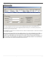
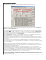
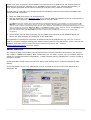
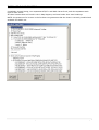
SOBvMAX
Release 5 & 6 – Notes
6 April 2006
This document outlines changes and additions since MAX Release 3.4.
MAX 3.4 is fully documented in the Online SOB User Manual at
www.digiboat.com.au/manual
The PDF User Manual installed with SOB and available for download from our website is now quite
out-of-date. We are re-writing the PDF User Manual which will be ready 2nd quarter. Multi-language
versions will follow shortly the completed English version.
R6 - MAJOR CHANGES and ADDITIONS
r6
Networking:
This release (SOBvMAX.6) mostly completes the WAN/Networking component of SOB.
Previously, SOB could connect to a host (or master) URL (or IP) Address as a client (or remote)
computer and input the NMEA Data Stream. Using and Displaying the host’s data as if it were from
directly connected devices (GPS, AIS, depth-sounder etc).
With SOBvMAX release 6, SOB can now act as a host computer and forward its directly connected
device’s data over a network (either, or both, a local LAN or WAN otherwise an intranet, or to the
Internet).
(see page 4 and the Networking Page from the SOB Online User Manual for more information)
r6
AIS:
In response to professional/commercial SOB user’s requests, the following two major feature
enhancements have been added to SOB’s AIS Targets implementation:
1. AIS data logging – refer to “Targets” section of this document
2. OwnShip from a Target
This allows you to directly use your ship’s own data when it’s received as an AIS target from your
own transponder - this means that for ships that receive themselves as a target from their AIS
transmission, they do not need to have a GPS and ROT indicator and electric compass directly
connected to SOB (via serial or USB etc). The data provided by these devices is read from the
received-self target.
(see page 9 for more detail about these two points, plus details of other enhancements to SOB’s AIS features)
r6
And more …
The NMEA form and Installed Charts form have been completely renewed allowing for greater
control, new feature interfaces and increased information display. The much requested ability to
reposition a waypoint with the mouse; Grey/Red/Black Night mode settings for Windows elements;
user selectable depth area shading and highlighting; more flexible display of the to-scale ship’s
shape; and look-ahead lines for either, both or none of, ship’s heading and course-over-ground.
14th Feb 2006
DigiBOAT – Software-On-Board Release Notes
Page 1
MISCELLANEOUS CHANGES
Compass direction added to true wind display in QuickInfo box for PastTrack points
Cardinal Marks icons added to Waypoint icon choices
r6
Move Waypoint with the Mouse (or touchscreen):
With the waypoint tool selected, Ctrl-click (or Shift-click) an existing Waypoint, the next left-click will
place the waypoint at that position.
To cancel wpt-move-mode and leave the waypoint in its old position, simply Ctrl (or Shift) click
anywhere on the chart, or cancel Waypoint mode by pressing the waypoint button, or any other of
the chart-tool buttons.
r6
r6
Night Modes:
[F7] adjusts the chart brightness (use SHIFT to change direction)
Pressing [Cntl] key toggles the function of the [F7] key between adjusting the chart brightness, and
cycling through GREY, RED and BLACK Windows colour themes.
Note for WinXP: If Win XP theme is in use, then the main title-bar of each window will be blue or
silver (depending on the theme setting). SOB’s Ctrl-F7 will not change the colour of the title-bar. The
Windows Classic theme must be separately selected (Control Panel >> Display >> Themes) for
SOB’s night-mode settings to change the title bars.
Depth Area Highlighting:
[F4] key functionality has changed in r6 – the previous Palette adjustment has been disabled, the
[F4] now toggles depth/height colour shading ON/OFF, and if Shading is ON, then [Shift] & [F4]
toggles on/off the ability to highlight a selectable range of depths (the highlighted depth range will
be coloured green).
The following keys are used to set the depth highlight range:
[Home] & [End]
moves the minimum depth contour value
[PgUp] & [PgDn]
moves the maximum contour value
With Shading ON, changes the depth “band” highlighted
With Shading OFF, moves blue sea colouring deeper/shallower
Note: the next values of max/min are 40% greater/less than the previous values. Depending on your
chart display, you may need to press these keys a few times until the next visible depth contour is
reached.
User Selectable Data Folders:
SOB has the facility to allow you to separate the data folders from the program folder. To change the
location of the data folders, they must be moved – all together – to the alternate location. If SOB
can’t find the SOBvMAX\LogFiles folder when it starts up, then a “Browse for Folder” pop-up will
allow you to select the new location, eg: C:\My Documents\sob\…
If a valid folder, containing ALL of SOB’s sub-folders is not selected then SOB start-up will be
aborted.
To fully support this new feature, two of SOB’s files have been relocated (and renamed):
WAN_list.txt
->
LogFiles\!WAN_list.txt
FRIENDS_list.txt
->
LogFiles\!FRIENDS_list.txt
Quick NavLine
Defaults to OFF
Default Box position banished to Siberia
PastTrack display:
Now that very large pasttracks are possible, this release has sped-up the chart redrawing when
many PastTrack markers are plotted.
14th Feb 2006
DigiBOAT – Software-On-Board Release Notes
Page 2
r6
r6
r6
If the display is larger than 3,500,000:1 then every 50 pasttrack points are drawn, and if the
display scale is larger than 750,000:1 then every 8 points are drawn.
Ctrl-click a pasttrack point to show the form (shift-click no longer opens PastTrack form, but is now dedicated
to skip the opening of the Ship’s Form and performing whatever other action is relevant)
Auto-Centre:
Auto-centre state is saved between sessions
Chart will refresh only if ship is moving away from centre of display, and is half-way from the
centre to the edge
For advanced users, the two parameters used to control the auto-centre mechanism can be
customised. Contact [email protected] for details.
Tides QuickInfo changed to "Click for Graph" (the quick tide predictions was inaccurate in some
areas)
Port Areas and Marina Information:
QuickInfo now shows the PORTAREA followed by a list of marinas, click to show Marina’s details.
Full Info (right-click) now correctly shows all details for each Marina
Arrow Keys for panning chart:
Toggle super-pan mode with the SHIFT key.
Super-pan will pan the chart 5 times further than normal pan mode.
Chart Datums:
Added preliminary support for different chart Datums
(as apparently needed for some South Pacific areas, and possibly others)
The LAT & LNG offset corrections must be manually added to the Registry (email
[email protected] for details)
The current offset values are printed to the Messages Panel on startup.
The applied shift can be toggled ON/OFF using the [6] key. The current setting will be shown in
the Messages Panel.
TIDE FORM
Limited testing shows that the ZULU timezone error may be fixed. (please report your findings to
[email protected])
Form display cleaned-up - better display when switching between Multi-media photos, Tide graph
and Object details.
Day & Dusk times now also adjusted with DST tickbox
Today’s current time marker is drawn from top to bottom of day graph in YELLOW
SHIP’S Form
Changed title to "Ship's Form" from "Settings and Display Options"
Added flexible Lat/Lng input to Ship's Form (use DD.ddd, or DD°MM.mm or DD°MM'SS")
r6
Ship’s Tools Page:
When drawing the scaled Ship Shape, a minimum chart scale for drawing the ShipShape can be
selected from a list of: 1:50000, 1:20000, 1:15000, or 1:10000.
Look-ahead lines can be selected for either HDG (actual direction ship is pointing) and/or COG
(actual direction ship is moving). Traditionally, the HDG would align with the “lubber-line” on an
analogue compass.
The Ship Shape can be selected to align to either the HDG or the COG.
14th Feb 2006
DigiBOAT – Software-On-Board Release Notes
Page 3
NETWORKING
REMOTE (aka CLIENT)
Only minor changes to this form have occurred. ([WAN Connect] button on Raw NMEA Form)
The connect status of any entry can be toggled by double clicking on it, and Primary Ship can be
selected by right-clicking the entry.
The IP Address or URL boxes are combined into one. Either a “dotted decimal” or URL can be entered
for the HOST computer.
Note that the HOST does NOT need to be a SOB computer. If you have the Network or Pro SOB
license and are interested, ask us for the addresses we have that connect to AIS repeaters in Seattle
and Norway. The Norwegian URL sends live data for the AIS traffic along the entire Norwegian
coastline - about 800 AIS targets! The Seattle one is similar, however usually about 70 targets are in
range. Likewise, if you know/have any addresses of TCP/IP NMEA data streams, or are transmitting
your own live data, we would be interested to hear from you!
14th Feb 2006
DigiBOAT – Software-On-Board Release Notes
Page 4
HOST (aka SERVER or MASTER)
This is (typically) the computer onboard with all your GPS etc directly connected:
A standard Internet Server socket is started when TCP/IP is selected as the choice for Multiplexer
Output on the Raw NMEA Data form.
Note: SOB will not automatically start the Server when SOB starts-up. You must “show the NMEA
Output page” before the Server will start, so double-click the chart, then select the NMEA Output
page. If TCP/IP output was pre-selected the Server will now be automatically started. Otherwise,
select TCP/IP from the drop-down list for Multiplexer.
When the Multiplexer check-box is ticked, SOB will redirect ALL incoming NMEA sentences from
ANY connected devices to the output source chosen (port 1 or 2, or TCP/IP).
When TCP/IP is selected, a remote computer (either a local network connection or connected over
the internet) running SOB can connect to your computer and have all your data mirrored to SOB on
the remote PC.
Note: at this stage, the other Output choices (GPS, Autopilot) do not have their TCP/IP output
choices enabled (we are yet to fully comprehend the implications of controlling an autopilot onboard
from a remote SOB!!!)
SOB allows a connection to any valid IP Address available on your computer, you would have
multiple IP addresses available if many network connections are present and enabled, eg: wireless,
LAN cable plug, Bluetooth, GPRS modem.
For the REMOTE (or CLIENT) computer running SOB to connect to you, they must know your
computers IP Address. If you are a single computer with broadband internet connection, your ISP
assigns a unique IP address to your computer. If your computer is on a local network, perhaps
connected to a LAN or WAN hub or other computer with Internet connection, then it will probably
have a local IP address (often similar to 10.1.1.xx or 192.168.0.xx).
With only a local IP address, any other SOB computers on your subnet can connect directly to you.
You would need to establish a VPN to allow remote SOB computers from over the Internet to connect
to your local session of SOB.
14th Feb 2006
DigiBOAT – Software-On-Board Release Notes
Page 5
Please note that connecting remote SOBs over the Internet to a SOB Server not directly Internet
addressed is beyond the mandate of our DigiBOAT Support Staff. Your network administrator, or
local TCP/IP Consultant would need to assist you with any tricky network connections.
All that said, it is actually very straight forward to establish a Server/Client sessions between two
networked SOB computers:
1. Start the SOB Host Server, as directed above.
2. Use the directions on the Network Page on our Online SOB User Manual to set up a connection to
the SOB Host computer. Mark this connection as “Primary Ship”.
Use 1001 for the port number (this is the SOB Server’s default listening port), and whatever your host comuter’s IP
Address is. There are many ways to discover your PC’s IP Address, Win XP displays it quickly by hovering the mouse
over the small computer icons flashing down near the Clock. Windows 2000 hides this information behind about 27 mouse
clicks. A simple way is to press Start then Run…, type cmd then [Enter], now in the DOS window, type ipconfig. Write
down the IP Address listed (eg: “220.236.198.158”) then close this DOS window.
This is the address along with Port 1001 that must be entered into the WAN Connect form of the remote SOB
computer(s).
3. There should now be data streaming into the NMEA form window on the REMOTE which will
mirror the data captured and displayed at the SOB HOST.
It is possible to override the automatic IP Address selected by SOB Server (eg: 127.0.0.1 can be
used for single PC loopback testing) the default listening Port for the SOB Server (1001) can also be
changed, and proxy server name (for client connections) can be set… contact
[email protected] for more details.
ABOUT SOB Form
The various C-Map Card Readers connected should be correctly identified and listed in the text box.
(eg: USBCC, USBMM and USBFP). New FSYS03.DLL (20-12-2005) version 3.3.0 is included with this
install for increased Usercard compatibility. C-Map UserCard library (FSYS03.DLL) version number is
printed to textbox
[View QuickStart Card] button should have better luck finding newer versions of Adobe Acrobat
Reader.
A list of available, and in-use, COM Serial Ports is included at the end of the Text Window as a
diagnostic aid.
14th Feb 2006
DigiBOAT – Software-On-Board Release Notes
Page 6
NMEA Form
Added sub-pages to the Raw NMEA Data form
Both SOB COM ports can now be controlled (selected, opened and closed) from within SOB via this
form (SOB_COM.EXE no longer required to set SOB’s ports)
NMEA Output:
You can now select which of SOB’s COM ports will be used for outputting NMEA commands (for
Autopilots, other NMEA input devices, and AIS units)
r6
A "Multiplex" mode is now available. This will combine ALL incoming NMEA data and re-send it on the
chosen port. The output can be either of SOB’s COM ports, or over a network or the Internet.
Multiplexer Serial Output is only enabled for Licensed SOB Users.
Multiplexer TCP/IP Output is only enabled for “Pro” or “Network” Licensed SOB Users.
Note: “All Wind” output doesn't require Autopilot to be ticked, however, the selected Autopilot Output
port will be used for sending Wind data.
NOTE: WPL/RTE outputs are not yet implemented.
NASA AIS Engine:
Allows some configuration options: Channel and Threshold. These can be configured within SOB and
sent to the NASA Receiver the next time the AIS COM port is closed then opened.
The newer versions of this popular AIS Receiver (manufactured after June 2005) have included a
"Channel Swap" ability for monitoring both AIS channels "A" and "B". This option can now be selected
from SOB.
Satellite Displays:
A new page is added to the NMEA form showing availability of satellites for GPS reception.
Serial In/Out buffers:
The size of the buffers used for receiving and transmitting NMEA data have been increased. This
should reduce problems for systems connected to many high-volume data providers (eg:
multiplexers)
There is also a provision for user-configuring of the Receive Buffer sizes, contact
[email protected] for more details
Other changes/fixes:
"SOB_NMEA_DATA.log" file can't be opened for replay. This is SOB’s default file for writing NMEA
data to. SOB will ignore any attempt to open this file for replay
Added Device Manager button on NMEA form for easily opening this useful Windows™ diagnostic
tool.
r6
Hardware Flow Control:
Some connected serial devices (eg: ACTISENSE OPTO Isolator, MiniPlex multiplexer) require
hardware flow control to be enabled for the serial port. SOB’s default setting is NO Flow
Control (requiring only a two-wire serial connection).
A check-box on the NMEA “COM Page” allows setting SOB to use hardware flow control
(also known as RTS/DTR control). Note: the serial plug must have additional connections
for these devices to work – consult your device connection manual/diagram for more
information).
14th Feb 2006
DigiBOAT – Software-On-Board Release Notes
Page 7
INSTALLED C-MAP CHARTS Form
Completely revised listing, now separates NT/NT+ and MAX charts found, and also separates each
type of chart found.
All chart licenses that are found in the C-Map Registry are listed under their own headings.
NOTE: the presence of a license in the list does not guarantee that the chart is correctly installed and
available for SOB’s use.
14th Feb 2006
DigiBOAT – Software-On-Board Release Notes
Page 8
TARGETS
New "Target limit" for Registered users – increased to 100 permitted targets.
A more comprehensive "TARGET LIMIT REACHED" message is displayed when the current limit is
reached. Target acquisition can be reset, if the limit is reached, only by restarting SOB.
Non-collision targets are now uncolored when in declutter [F8] mode.
New ITU-1371 messages decoded:
"Class B position report" messages 18 & 19
(NOTE: The NASA Receiver DOES NOT process and forward messages 18 & 19)
"Aid to Navigation report" message 21 (NASA does process this message)
Acquired NavAids print as a circle. Coloured Red if Off Position (or a collision threat)
QuickInfo box will show quick data about the NavAid (as with other Targets)
r6
Message Type 8 – Binary Broadcast Message
If this message contains a short text message, the message will be printed to the purple
Messages panel
Targets N/A data:
If SOG is not available, SOB will display "N/A" for target speed. Collision Potential calculations for
these targets may be invalid (unless target is travelling at VERY low speed).
If COG received data is invalid, SOB will show target with a heading of 360°True (due-North). A
correct Northerly heading is shown as 0°True.
If LAT/LNG data received is invalid, target will be set to (0,0) – The Gulf of Guinea
r6
OwnShip as a Target:
Many commercial cargo ships with AIS Transponders will receive their own transmissions as an
acquired target. SOB will now interpret this OwnShip target correctly and will use the received AIS
for OwnShip data. This means that if the AIS Transponder is wired into the PC running SOB, then
separate connections for GPS and Gyro/Fluxgate are NOT required. SOB will use the AIS Dynamic
data for these devices.
NOTE: The OwnShip MMSI must be correctly entered on the Ship’s Form >> AIS Static Data page
for this feature to work.
AIS Target Logging:
r6
There is an optional check-box on the Acquired Targets Form
[T] which will enable AIS data logging. A plain tab-delimited
text file !AIS_DATA.txt is appended in the SOBvMAX\LogFiles
folder ready for importing/opening directly in Excel (or similar).
This file contains data such as Target Name, MMSI, lat/lng and
UTC when first acquired, lat/lng and UTC when target lost etc.
The target info is written to this file when the target is deleted by the user, or when it is autopurged, or when SOB exits.
This file is not available while SOB is running – ie: file copy, rename, delete etc will produce an error
if SOB is running.
14th Feb 2006
DigiBOAT – Software-On-Board Release Notes
Page 9
ROUTES
New Functions and AutoPilot control:
[Reset XTE] button on Route Data form to reset the XTE to Ships Position. This is mostly suitable
for sailing craft under Autopilot Control that may end up a fair distance from their original intended
track. The autopilot will try to steer the yacht back to the original track, rather than continue to the
destination from the yacht’s current position.
This button, effectively resets the intended track to: the yacht’s current position to the destination.
A motor boat may need to use this button if they detour off an intended track for any reason, and do
NOT need to return to the initial track line before resuming the leg.
In either case (sail or motor) care would need to paid to the safety of NOT resuming the original
intended track, as it may have been plotted to avoid submerged objects, or land-masses etc.
" [ ] Use Aft-a-Beam" tickbox on the AllRoutes form. This setting is again most particular to sail
craft under autopilot control while following an Active Route. With this box ticked, if your craft turns
away from your destination point for about ten seconds, the destination point is considered as been
"passed", and the following route TurnMark then becomes the destination mark.
However, with this tickbox cleared, then your craft must pass inside the pre-set Arrival Zone of the
destination TurnMark for it to be considered as "passed".
Craft under motor are obviously much better at following a precise course under autopilot control.
And are thus better able to "hit" a small arrival circle at the destination. However, a motoring ship
can still deviate from the course, and trigger an "aft-a-beam" situation (eg: an increasing strong
cross-current, turning around to reel in a fish, deviating to check an echo while side-scanning a
course, investigating an object seen floating a way off your track, etc).
r6
For an Active Route, a dampening value has been incorporated on the Planned arrival speed and
Planned TTG, to stabilise this value. The dampening will average the previous 10 values of the
“required speed for planned ETA”. This value can be changed, if necessary. This is an advanced user
setting – please contact [email protected] for details.
ArrivalZone timing:
The amount of time inside the arrival zone, before the autopilot changes to the new course, has been
doubled. It is now about 15-20 seconds from the time that the arrival zone is breached, before the
autopilot receives a command to change to the new course. This should be considered when setting
the size of the Arrival Circle. An interim message is sent to the Messages panel warning: "Prepare for
course change … " before the final message is posted: "Turning now …"
Route Exporting (and converting Routes to Waypoints):
A new [To Text List] button on the RouteData form will create a .TXT file opened in Windows™
NotePad with a listing of Route legs, in a very similar format to the listbox on the form.
This route text file can be used to print-out the route details, or for importing into Excel, or can be
used to convert the route into a SOB waypoints file.
To convert to waypoints, save the NotePad file into the SOBvMAX\Waypoints folder, ensuring it
has a ".txt" file extension, then use the AllWaypoints form and click on this filename to be
automatically converted to a SOB ".wpt" file format.
NOTE: for successful WPT conversions, ensure that the "#" (hash) character is the first character on
any line not used for waypoint importing (these lines are ignored). The original route text file that
SOB creates, clearly demonstrates which lines should not have the hash character. Although the
start waypoint will be overlooked with the text file format, if you would like to include this start mark
in the waypoint list, then copy its details from the header to the list.
Route Editing:
Inserted turnmarks with the outside marks placed on different sides of the 180° longitude are now
correctly located. Also more GreatCircle leg combinations crossing the 180° longitude work correctly,
although there are still some combinations that give erratic results. Often these can be created
successfully by first reversing the route, then converting the leg to a GC, then reversing the route
again.
14th Feb 2006
DigiBOAT – Software-On-Board Release Notes
Page 10
Inserted turnmark names are created more logically. There should now rarely be adjacent inserted
marks with the same label.
IE: previously, it was possible to have, say:
TP-1, INS-1, INS-2, INS-1, INS-2, TP-2 as turnmark names.
These would now become:
TP-1, INS-1, INS-11, INS-12, INS-2, TP-2 etc
(of course, the name used is determined by which order the marks are inserted and deleted, so are
likely to be different from the example).
r6
The text Labels for the TurnMark are drawn more intelligently and try to avoid being drawn on top of
the leg-line.
When the Route Tool is selected, clicking an existing Waypoint will pop-up a message box asking to “Add Wpt to
Route”. To avoid showing this message box, hold down [Ctrl] or [Shift] key when clicking the Waypoint.
Route Edit MenuBar:
The name of the TurnMark now appears on the titlebar of this button menu.
When pressing a turnmark twice, near the lower part of the display, the MenuBar was "popping-up"
off the bottom of the screen, out of sight and apparently "freezing" the display. The MenuBar will
now always appear on the visible part of the screen.
VIEW PANELS
The Ship’s Data panel now includes a "compact" mode to help save screen space.
All ViewPanels will "remember" their positions when SOB is closed, these positions will be restored
when SOB next starts up.
Their positions will be correctly restored also on multi-monitor setups, the Ship’s Data panel can now
be placed on any monitor.
NOTE: All Panels will be displayed in their default positions when the [Show All] button is pressed on
the View Panel Menubar.
If SOB is shutdown while displayed on a monitor other than the Primary, and then restarted without
the other monitor connected, then SOB will not be visible (as its window will be restored to the nonexistent monitor).
r6
To "find" SOB again,
you can try holding SHIFT down while starting SOB which tries to force redraw to active monitor
however this may not always be successful,
in which case you can manually place the SOB window into "Restore" mode, then move it (blindly) to
the Primary monitor, or delete the window placemenets settings in the Registry before restarting.
Both of these methods are quite advanced, so please email us for more instructions if required.
For advanced users only:
The Registry key is: HKEY_CURRENT_USER\Software\SoftwareOnBoard\sob\Settings\Windows
..and delete these values: pos_bottom, pos_top, pos_left, pos_right and pos_minmax.
14th Feb 2006
DigiBOAT – Software-On-Board Release Notes
Page 11
BUG FIXES
V5
** Fixed possible crash when double-clicking an entry on the WAN form
** Fixed possible crash when "Name" column is blank in "Find" form
** Fixed tooltips for [Info] button
** Fixed display of Ports/Marinas info (some locations weren’t showing all Marina data)
** Tweaked the processing of incoming NMEA sentences to speed it up processing and help slower
systems with many devices connected.
V6
** Changed control of Route Names when created from the C-Map UserCard
** Fixed including a hit wpt in a rte (was reverting back to first or last wpt in list)
** Fixed conversion of an exported Route into a Waypoint list
** Fixed importing of Wpts from GPS when lat/lng are in DD°MM’SS” format
** Fixed MUX output from all NMEA sources
** Fixed disabling "Show Callsign" label checkbox on Target form
** WAN Form doesn't need to be closed/reopened after adding new WAN entry
END of DOCUMENT
14th Feb 2006
DigiBOAT – Software-On-Board Release Notes
Page 12