1
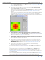
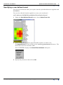
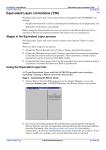
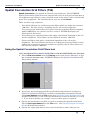
INTREPID User Manual
Library | Help | Top
Spatial Convolution Grid Filters (T34)
1
| Back |
Spatial Convolution Grid Filters (T34)
Top
Spatial Convolution is a method of enhancing a grid dataset. The INTREPID
Spatial Convolution Grid Filters tool compares the value of each grid cell with that of
its neighbours and adjusts it using a formula based on the values of the cell itself and
those of its neighbours. The formulas that it uses are called Kernels.
There are three type of kernels:
•
User defined kernels are coefficient matrix filters which are defined in external
.ker files. The files specify a weighting for the cell and its neighbours.
You can select the kernel that you require from the predefined kernels supplied
with INTREPID or use a kernel you have created. INTREPID displays an
illustration of the kernel.
•
Preset kernels are statistical filters that apply a predefined algorithm to the cell
and its neighbours. These filters are not stored in external .ker files.
•
Tensor grid filters that apply a predefined algorithm to the cell and its
neighbours. The basis function used here is a 3D spatial truncated Fourier series,
without the requirement that the samples be regularly spaced. These filters are
not stored in external .ker files.
Using the Spatial Convolution Grid Filters tool
>> To use Spatial Convolution Grid Filters with the INTREPID user interface
Library | Help | Top
1
Choose Grid Convolution from the Filtering menu in the Project Manager, or type
the command cfilter.exe. INTREPID displays the Spatial Convolution Grid
Filters Main window.
2
If you have previously prepared file specifications and parameter settings for
Spatial Convolution Grid Filters, load the corresponding task specification file
using Load Options from the File menu. (See Specifying input and output files for
detailed instructions.) If all of the specifications are correct in this file, go to step
7. If you wish to modify any settings, carry out these steps as required.
3
Specify the grid dataset on which you wish to perform the Spatial Convolution.
Choose Open Input Dataset from the File menu. (See Specifying input and output
files for detailed instructions.)
4
Specify the output grid dataset to be created with the results of the process.
© 2012 Intrepid Geophysics
| Back |
INTREPID User Manual
Library | Help | Top
Spatial Convolution Grid Filters (T34)
2
| Back |
Choose Specify Output File from the File menu. (See Specifying input and output
files for detailed instructions.)
5
Specify the convolution filter you wish to use from the User Defined Kernels
menu, Preset Kernels or Tensor menu.
If you select a statistical filter from the Preset Kernels menu, specify the window
size and any other parameters required (See Specifying a preset kernel for
details).
If you select a user defined kernel, specify the edge processing option and whether
to normalise (See Specifying a user defined kernel for details). INTREPID
displays a coloured pattern which graphically illustrates the user defined kernel.
6
Specify whether you require the output grid dataset to contain the convolved
(corrected) values or values of the corrections only. If you wish to save the
corrections only, turn on the Save Residuals box in the Spatial Convolution Grid
Filters main window. See Apply for instructions.
7
When you have made specifications and settings according to your requirements,
choose Apply. INTREPID will perform the Spatial Convolution process and save
the results to the specified output dataset.
8
If you wish to record the specifications for this process in a task specification
(.job) file in order to repeat a similar task later or for some other reason, use
Save Options from the File menu. (See Specifying input and output files for
detailed instructions.)
9
If you wish to repeat the process, repeat steps 2–8, varying the kernels,
parameters and/or data files as required.
10 To exit from Spatial Convolution Grid Filters, choose Quit from the File menu.
___
To view the current set of specifications choose Report from the Window menu.
INTREPID displays the Spatial Convolution Grid Filters Report window. See
Displaying options and using task specification files for details and an example of a
set of specifications.
You can view Help information by choosing options from the Help menu (See Help).
You can execute Spatial Convolution Grid Filters in batch mode using a task
Library | Help | Top
© 2012 Intrepid Geophysics
| Back |
INTREPID User Manual
Library | Help | Top
Spatial Convolution Grid Filters (T34)
3
| Back |
specification (.job) file that you have previously prepared. See Displaying options
and using task specification files for details.
Specifying input and output files
To use Spatial Convolution Grid Filters, you will need to specify the name of the grid
dataset you wish to process and a name for the output grid dataset containing the
results.
Choose the options as required from the File menu.
In each case INTREPID displays an Open or Save As dialog box. Use the directory
and file selector to locate the file you require. (See "Specifying input and output files"
in Introduction to INTREPID (R02) for information about specifying files).
File menu options
Open Input Dataset Use this option to specify a grid dataset you wish to enhance
using the Spatial Convolution process.
Specify Output File Use this option to specify the name for the output grid dataset
you are creating with the Spatial Convolution process.
Load Options If you wish to use an existing task specification file to specify the
Spatial Convolution process, use this option to specify the task specification file
required. INTREPID will load the file and use its contents to set all of the
parameters for the Spatial Convolution process. (See Displaying options and
using task specification files for more information).
Save Options If you wish to save the current Spatial Convolution Grid Filters file
specifications and parameter settings as an task specification file, use this option
to specify the filename and save the file. (See Displaying options and using task
specification files for more information).
User defined kernel files
User defined kernel (.ker) files reside in the install_path/kernel directory.
When you display the User Defined Kernels menu, INTREPID builds the menu from
the names of files in that directory. When you choose an item from the directory, you
load the corresponding user defined kernel file. See "User defined grid kernels supplied
with INTREPID" in INTREPID spatial and time domain filters and transformations (R13) for
information about the kernels supplied with INTREPID.
If you wish to add your own user defined kernels, simply place them in this directory.
See Creating and editing user defined convolution kernel files for instructions.
Library | Help | Top
© 2012 Intrepid Geophysics
| Back |
INTREPID User Manual
Library | Help | Top
Spatial Convolution Grid Filters (T34)
4
| Back |
Specifying a user defined kernel
You can select the kernel that you require from the predefined kernels supplied with
INTREPID.
You can also edit the kernels supplied or create your own kernel.
>> To select an INTREPID predefined Convolution kernel
1
Under the User Defined Kernels menu, choose Select From List.
2
From the Select Kernel list, choose the filter option you wish to use.
The Select Kernel list lists all files in the install_path/kernel directory. The
kernel files have the extension .ker.
Next, INTREPID displays the Kernel Filter Attributes dialog box.
3
Library | Help | Top
Specify the parameters then choose OK.
© 2012 Intrepid Geophysics
| Back |
INTREPID User Manual
Library | Help | Top
Spatial Convolution Grid Filters (T34)
5
| Back |
Kernel filter attributes
Chop kernel / Null kernel
When INTREPID is processing the edge of the grid, the convolution formula may
require values from cells that do not exist because they would be outside the grid.
You can use the Chop Kernel / Null Kernel option buttons to specify the action that
INTREPID should take at the edge of the grid.
Chop Kernel If you choose this option, INTREPID will reduce the number of cells
used in the kernel at the edges of the grid so that it does not attempt to refer to
nonexistent cells.
Null Kernel If you choose this option, INTREPID will allocate null to a target cell if
a nonexistent cell is within the scope of the kernel. This is likely to happen along
dataset edges or near data gaps.
Normalising kernels
If you turn on the Normalise check box, INTREPID will adjust the kernel so that the
sum of its weights is one. The output grid will then have the same mean value as the
input grid.
Creating and editing user defined convolution kernel files
You can use any text editor to create and edit convolution kernels. You can define
your own from scratch or use a supplied kernel file as a template. If you define
further kernels and store them in install_path/kernel with extension .ker,
INTREPID will automatically include them in the User Defined Kernels menu. See
"User defined convolution kernel (.ker) files" in INTREPID spatial and time domain
filters and transformations (R13) for further details.
User defined kernel display
INTREPID displays an illustration of the kernel that you have selected in a display
box in the main window.
The box contains a matrix of squares, each assigned a colour. The central square
represents the target cell of the formula. The other squares represent the
neighbouring cells that are involved in the formula. The colour of each square
represents the weight that it carries in the kernel formula. Red cells carry the
highest weight and blue cells carry the lowest weight. A green cell carries an average
weight (usually 0).
Many of the convolution kernels naturally have the target cell carrying the highest
weight. In these cases the Kernel Illustration has one red square and a number of
green and blue squares.
Library | Help | Top
© 2012 Intrepid Geophysics
| Back |
INTREPID User Manual
Library | Help | Top
Spatial Convolution Grid Filters (T34)
6
| Back |
The number of squares and colours in a kernel illustration box varies according to the
number of cells involved in the formula and the number of different weights assigned
to cells. INTREPID automatically selects the numbers of squares and colours to
provide the optimum illustration of each kernel.
Specifying a preset kernel
In addition to the kernels provided in .ker files, the Spatial Convolution Grid Filters
tool has a number of internal filters which apply a predefined algorithm to the cell
and its neighbours. You can specify these using options from the Preset Kernels
menu.
Local median Filter
This filter adjusts the value of the target cell based on the median value of the cell
and its neighbours in a window.
To use the local median filter
Choose Median from the Preset Kernels menu. INTREPID displays the Local
Median Filter for Grid dialog box.
Specify the window size, then choose OK.
Library | Help | Top
© 2012 Intrepid Geophysics
| Back |
INTREPID User Manual
Library | Help | Top
Spatial Convolution Grid Filters (T34)
7
| Back |
See "Local mean / median filters" in INTREPID spatial and time domain filters and
transformations (R13) for further instructions.
Contrast Normalisation Filter
This is a non-linear space variant stretch filter that will enhance the low amplitude,
high frequency content, and dampen the high amplitude content. It has a similar
effect to an AGC (Automatic Gain Control) filter.
>> To use a contrast normalisation filter
Choose CNorm from the Preset Kernels menu.
See "Contrast normalisation filter for grid data" in INTREPID spatial and time
domain filters and transformations (R13) for further explanation of parameters.
Gaussian Anti-alias filter
This is a standard convolution filter whose aim is to look for non-Gaussian aspects to
the signal in any one direction within the window and normalise the grid values by
nudging.
The argument for this style of filter arises when you have much higher frequency
data along survey profile lines, as you may have a sample every 6 meters, than across
the lines, as the line seperation maybe say 100m, with a 25m cellsize. Often, a low
pass filter such as a Butterworth, can be applied along the profile, to more or less
match the along profile wavelengths, to what can be successfully captured in the
across-line direction. In the case mentioned above, wavelengths less than 100m, if left
in the profiles while gridding, will cause frequency aliasing to occur in the grid. This
Gaussian spatial convolution filter can then be applied to try and remedy the
situation.
Terracing filter
This is an interesting idea from the USGS. The aim here is to automatically classify
zones in your geophysics grid that derive from distint underlying geology. An example
that makes immediate sense, is to consider a Total count gamma ray grid, and to look
for regions with like counts, and then making the jump to claim these regions define
closed polygons of like-geology.
The algorithm works by finding local maximum and minimum anomalies, and
working from these points to find the flexure lines defining the flexural change of
gradient. By iteratively filling the “valleys”, and stripping the “hills”, in the signal (
the so-called terracing process), bounding polygons emerge for each region.
INTREPID have attempted some further optimizations and extensions to this idea,
including writing out GIS polygons. It turns out to be easily stated, as above, but
hard in practise to get anything but the simplest of algorithms to work. This is
similar to a GIS Classifier algorithm.
Library | Help | Top
© 2012 Intrepid Geophysics
| Back |
INTREPID User Manual
Library | Help | Top
Spatial Convolution Grid Filters (T34)
8
| Back |
Specifying a Tensor Grid Convolution Operation
Two types of operations are supported Estimation of errors in the tensor grid via the use of a difference of the estimated
tensor from neighbouring cells, to what is contained at the current cell.
Estimation of the Local Potential, smoothing this and then re-estimating a smoothed
tensor grid.
A Fourier Series is fitted to the tensor observations in a local 3,5,3 samples/row
pattern. The coefficients are solved for using a Single Value Decomposition so as to
get a best fit in a least squares sense.
You can save off the 48 coefficients to a multi-band grid. If this coefficients grid, and
the potential grid are the basis for being able to estimate any tensor or vector
component or gradient at every point in the grid. It is surprising how similar the
Potential grid can look to the vertical component of gravity. This is mostly a
mathematical exercise, and it enables a quite viable grid smoothing technique that
contrasts with the MITRE FTG technique.
The final option is the estimation of the vertical component of gravity from this set of
coefficients and the potential. As this is derived from a local 5*5 window, it has a lot
of the character of a high passed version of the vertical component.
Convolution status and progress reporting
Kernel description, rows, columns
INTREPID displays information in the status area at the top of the Command area of
the Spatial Convolution Grid Filters Main window.
INTREPID uses status area to display a brief description of the current kernel and
the number of rows and columns of neighbouring cells that are involved in the
formula.
Library | Help | Top
© 2012 Intrepid Geophysics
| Back |
INTREPID User Manual
Library | Help | Top
Spatial Convolution Grid Filters (T34)
9
| Back |
Apply
After you have specified the spatial convolution filter required you can apply the filter
to the grid.
>> To apply the filter
1
2
Use the Save Residual check box in the command area to specify whether to save
1
New filtered grid (turn off) or
2
Values of changes to the grid (turn on).
Choose Apply. INTREPID will apply the filter and save the results.
Help
You can use the Help menu to display help text on the topics shown in the menu
illustration below.
Exit
To exit from Spatial Convolution Grid Filters choose Quit from the File menu.
Library | Help | Top
© 2012 Intrepid Geophysics
| Back |
INTREPID User Manual
Library | Help | Top
Spatial Convolution Grid Filters (T34)
10
| Back |
Displaying options and using task specification files
Displaying options
To display the current file specifications and parameter settings, choose Report from
the Window menu.
INTREPID displays the Spatial Convolution Grid Filters Report window containing
the task specifications.
Using task specification files
You can store sets of file specifications and parameter settings for Spatial
Convolution Grid Filters in task specification (.job) files.
>> To create a task specification file with the Spatial Convolution Grid
Filters tool
1
Specify all files and parameters.
2
If possible, execute the task (choose Apply) to ensure that it will work.
3
Choose Save Options from the File menu. Specify a task specification file
(INTREPID will add the extension .job) INTREPID will create the file with the
current parameters.
For full instructions on creating and editing task specification files see INTREPID
task specification (.job) files (R06).
>> To use a task specification file in an interactive Spatial Convolution Grid
Filters session.
Load the task specification (.job) file (File menu, Load Options), modify any settings
as required, then choose Apply.
>> To use a task specification file for a batch mode Spatial Convolution Grid
Filters task
Type the command cfilter.exe with the switch –batch followed by the name (and
path if necessary) of the task specification file.
For example, if you had a task specification file called surv329.job in the current
directory you would use the command
cfilter.exe –batch surv329.job
Library | Help | Top
© 2012 Intrepid Geophysics
| Back |
INTREPID User Manual
Library | Help | Top
Spatial Convolution Grid Filters (T34)
11
| Back |
Task specification file notes and example
Here is an example of a Spatial Convolution Grid Filters task specification file.
Process Begin
Name = Convolve
InputImage= /disk1/data/mlevel_grid
OutputImage = /disk1/data/mlevel_C
Parameters Begin
Type = Convolve
Kernel Begin
Kernel = "low_pass_4.ker"
NormaliseWeights = Yes
ChopWeights = Yes
NullWeights = No
Kernel End
Residual = No
Parameters End
Process End
Frequently asked questions
Q : Can I run an AGC filter on a grid?
The CNorm (Spatial Contrast Normalisation) filter is a non-linear space variant
stretch filter, which enhances the low amplitude, high frequency content and
dampens the high amplitude content. It operates on gridded data, and has a similar
effect to an Automatic Gain Control filter.
It is located under Preset Kernels > CNorm
Library | Help | Top
© 2012 Intrepid Geophysics
| Back |