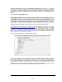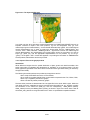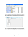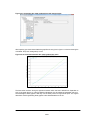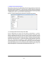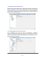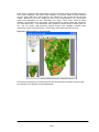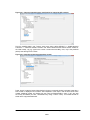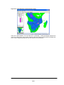
1
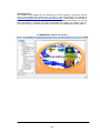
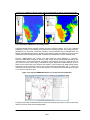
African Monitoring of the Environment for Sustainable Development Date:12-04-2012 Issue: version 1.0 AMESD SADC THEMA TOOLBOX PLUG-IN FOR ILWIS 3.7.2 or higher INSTALLATION, CONFIGURATION AND USER GUIDE XML Version 1.1 Name Responsibility Prepared by Farai Marumbwa Thematic Expert AMESD-BDMS Contributions from Ben Maathuis & Chris Mannaerts Martin Schouwenburg, Bas Retsios and Rob Lemmens Thembani Moitlhobogi Department of Water Resources & Department of Geo-Information Processing, UTITC System Engineer, AMESD-BDMS Geert Borstlap TA-TE, AMESD-BDMS Ben Maathuis Department of Water Resources, UT-ITC Isaac Kusane Project manager, AMESD-BDMS Reviewed by Approved by Acknowledgement This manual has been adapted from the “GEONETCast Toolbox Installation, Configuration and User Guide” of the GEONETCast Toolbox plug-in for ILWIS 3.7 manual developed by ITC (available at: http://52north.org/downloads/earth-observation/geonetcast/toolbox). Special thanks to Ben Maathuis who laid a solid foundation for the development of the AMESD SADC Thema toolbox. He has also been instrumental in supporting the toolbox development and checking for possible bugs. The supervision and support provided truly helped to further develop the AMESD-SADC Region Toolbox. The AMESD-SADC Toolbox User Interface Document: AMESD SADC THEMA Toolbox Plug-in for ILWIS. Installation, Configuration and User Guide Manual 2/37 Abstract The AMESD program addresses the need for improved environmental monitoring towards sustainable management of natural resources in five regions of sub-Saharan Africa, namely CEMAC, ECOWAS, IGAD, IOC and SADC Regional Economic communities (RECs). The program is implemented under the coordination of the African Union Commission with the support of the European Union. In the SADC region, the theme is “Agricultural and Environmental Resource Management”. AMESD SADC-Thematic Action The SADC thematic action is developing three information services namely Agriculture, Drought and Fire in order to address the already prioritized decision needs for the SADC region. The Agricultural Service monitors the state of the crops and rangeland. The Drought Service monitors drought during the whole year and provide drought outlooks. The Fire Service provides a daily fire risk indication, detection and follow-up of active fires (in real time) and burnt area assessments during the fire season. In order for the user community to handle and process the data from these three services the “AMESDSADC Toolbox” has been developed. The AMESD-SADC Toolbox allows the user to import a multitude of data from the AMESD SADC Thema disseminated via “EUMETCast-GEONETCast” into the freeware and open source RS-GIS ILWIS package and its existing processing capability can be used for further analysis. This document is proving a description where to download all the freeware utilities, how to install and configure them. The Toolbox developed is an open utility. It can be easily modified and tuned to fit the specific user needs without programming skills. Next to this description also an overview is presented on the various data types disseminated that can be imported and processed. Finally the document provides hands-on exercises how to use the utilities offered and is exploring the “AMESD-SADC” products. The exercises provided are focusing on the data from the three prime services, namely agriculture, drought, fire and the long range forecasting support service. The utilities provided are extensively tested using various operating systems, such as Windows Vista, XP (various service packages) and Windows-7 and have found to be performing in a stable manner. The toolbox currently does not work under LINUX. In case unexpected behaviour or bugs are observed, additions to the functionality are required or if you have developed new utilities that you want to share, please contact Farai Maxwell Marumbwa (email: [email protected]). April 2012 Farai Maxwell Marumbwa Thematic Expert AMESD SADC THEMATIC ACTION Botswana Department of Meteorological Services Plot 54216 Corner Maaloso & Metsimotlhaba Road Gaborone - Botswana Further information with respect to the AMESD-SADC Thema and Products can be obtained from: http://www.amesd.co.bw/ Further information with respect to the overall AMESD programme can be obtained from: http://amesd.org/ Sample data used within this manual can be retrieved from the following locations (including a short description of how the data should be installed on your system, also given in appendix 5): http://amesd.co.bw/file/Data/amesd_sadc_sample_data/ or ftp://ftp.itc.nl/pub/52n/amesd_sadc_sampledata/ Document: AMESD SADC THEMA Toolbox Plug-in for ILWIS. Installation, Configuration and User Guide Manual 3/37 Background As from July 2011 environmental data relevant for agricultural, drought and fire analysis from the SADC region are operationally produced and disseminated to the global user community using GEONETCast. Users anywhere in the world can have access to this data stream using a (low cost) ground receiving station. There is no need for an Internet connection to be able to receive large volumes of environmental related data. The data for the SADC region is mainly decadal data and after the end of each 10 day period, the products are disseminated. The majority of the products are produced at BDMS but for the drought, fire and the seasonal weather forecasts services other organizations are collaborating within the AMESD SADC programme, such as ARC, CSIR and SAWS from South Africa. In order for the User Community to easily ingest the data and products from the SADC region an Open Source and freely available Toolbox has been produced. This toolbox allows the import of the various products into a common GIS-RS environment for further analysis. As the overall number of images and products delivered through GEONETCast is growing steadily, it was concluded that it would be much easier for the Users from Southern Africa to develop a Toolbox that would only allow import of the products from the SADC region, produced under the AMESD programme and this resulted in the development of the AMESD-SADC Toolbox. This Toolbox is identical in design as the so called GEONETCast Toolbox, which allows import of an extensive number of images and products disseminated via GEONETCast. Interested Users can also obtain this toolbox freely. For further information on these utilities consult http://www.itc.nl/Pub/WRS/WRS-GEONETCast or http://52north.org/communities/earth-observation. Most of the products adhere to the map extent details presented below and cover the SADC Region. Lat/Long - WGS 84 (pixel size: 1x1km) Corner Coordinates (degrees): ulx = 11 uly = 6 lrx = 41 lry = -35 Further details are presented in this document. Note that an archive, containing the latest three dekades of products, is available to the User Community as well. The data can be obtained from http://www.amesd.co.bw/products/. Document: AMESD SADC THEMA Toolbox Plug-in for ILWIS. Installation, Configuration and User Guide Manual 4/37 Glossary 52North---------------------ARC-------------------------AMESD---------------------AU---------------------------BCA-- ----------------------BDMS ----------------------CSIR -----------------------CB EC---------------------------EO---------------------------EUMETSAT---------------UT-ITC---------------------SADC-----------------------SAWS-----------------------TA---------------------------TE---------------------------- 52°North-Initiative for Geospatial Open Source Software GmbH (Germany) Agricultural Research Council (South-Africa) African Monitoring of the Environment for Sustainable Development African Union Botswana College of Agriculture (Botswana) Botswana Department of Meteorological Services (Botswana) Council for Scientific and Industrial Research (South-Africa) Capacity Building European Commission Earth Observation European Organisation for the Exploitation of Meteorological Satellites Faculty of Geo-Information Science and Earth Observation, University of Twente (Netherlands) Southern African Development Community South African Weather Service Technical Assistance Technical Expert Document: AMESD SADC THEMA Toolbox Plug-in for ILWIS. Installation, Configuration and User Guide Manual 5/37 Table of Contents 1. GENERAL INSTALLATION AND CONFIGURATION INSTRUCTIONS ......................... 7 1.1 Introduction ................................................................................................................. 7 1.2 Download ILWIS .......................................................................................................... 7 1.3 Download the AMESD-SADC Toolbox ...................................................................... 7 1.4 Download IrfanView .................................................................................................... 8 1.5 Concluding remarks ................................................................................................... 8 2. OVERVIEW OF THE AMESD-SADC TOOLBOX ARCHITECTURE ............................... 9 2.1 Introduction ................................................................................................................. 9 2.2 Structure of the AMESD-SADC toolbox .................................................................... 9 2.3 Structure of the Config xml...................................................................................... 10 2.4 General AMESD-SADC Toolbox Configuration - Folder Settings ........................ 12 2.5 Structure of THE AMESD SADC Toolbox Scripts .................................................. 13 2.6 Structure of the AMESD-SADC Toolbox Batch Routines ..................................... 14 2.7 Using the AMESD-SADC toolbox in conjunction with the e-Station .................... 15 2.8 Advanced use............................................................................................................ 15 2.9 Concluding remark ................................................................................................... 15 3. EXPLORING THE AMESD-SADC THEMA PRODUCTS USING THE AMESD-SADC TOOLBOX .................................................................................................................................. 17 3.1 Introduction ............................................................................................................... 17 3.2 IMPORT OF AGRICULTURE SERVICE PRODUCTS (Onset of Rains Map & NDVI) .................................................................................................................................... 17 3.2.1 Importing Onset of Rains Map ............................................................................................. 17 3.2.2 Import of a 10-day NDVI product ......................................................................................... 20 3.2.3 Import of Time series graph products .................................................................................. 21 3.3 IMPORT OF FIRE SERVICE PRODUCTS ................................................................. 24 Importing Canadian Forest Fire Danger Index (CFWI). ....................................................... 24 Importing the MSG Active Fire (FIR) product....................................................................... 25 3.3.1 3.3.2 3.4 IMPORTING DROUGHT SERVICE PRODUCTS ...................................................... 26 Importing Vegetation Condition Index (VCI) product ........................................................... 26 3.4.1 3.5 IMPORTING LONG RANGE FORECAST (LFR) DATA ............................................ 28 Introduction ......................................................................................................................... 28 Importing the Seasonal Rainfall Forecast ............................................................................ 28 3.5.1 3.5.2 4. 5. CONCLUDING REMARKS ............................................................................................ 31 APPENDICES ................................................................................................................. 32 Appendix 1: Current products supported by the AMESD-SADC toolbox, XML version 1.1............... 32 Appendix 2: List of abbreviations and product acronyms ................................................................. 34 Appendix 3: AMESD SADC Thema file naming convention ............................................................. 35 Appendix 4: Other freeware utilities that can be used in conjunction with ILWIS .............................. 36 Appendix 5: Downloading and storing sample data for exercises..................................................... 37 Document: AMESD SADC THEMA Toolbox Plug-in for ILWIS. Installation, Configuration and User Guide Manual 6/37 1. GENERAL INSTALLATION AND CONFIGURATION INSTRUCTIONS 1.1 INTRODUCTION Follow the instructions provided below to install ILWIS Version 3.7.2, the AMESD-SADC Toolbox and a number of other free software utilities, in order to work with the AMESD SADC Thema data provided via GEONETCast. Read the instructions provided below carefully and proceed with the installation of the various utilities. In case you want to use the AMESD-SADC Toolbox, be aware that at this moment it is not running under LINUX-Ubuntu. Furthermore this AMESD-SADC Toolbox version is not downwards compatible; you need to use at least ILWIS Version 3.7.2. 1.2 DOWNLOAD ILWIS http://52north.org/ From this location select the navigation tab: “Downloads” or directly select “http://52North.org/downloads/ILWIS”. Select the latest (multiple file) ILWIS372 version (“ILWIS 3.07.02”) and download the ZIP file(s), save the file(s) in a temporary directory on your hard disk. Unzip the file and run the ILWIS setup. When you intend to use the AMESD-SADC Toolbox do not install ILWIS372 under the default installation directory “C:\Program Files” as this might cause problems with respect to administration rights (especially under Windows 7) when creating temporary files and because the toolbox is utilizing DOS batch routines, which can be affected by the space in the directory file name “Program Files”. Select as your installation “drive:\directory” a location where you have the proper administrative rights (e.g. “D:\ILWIS372”). In the “ILWIS372” directory a shortcut to the “ILWIS.exe” can be created, you can copy this shortcut to the desktop of your system. Please ILWIS: take into consideration, straight from the start, the following golden rules when using Don’t use spaces in file names, instead use underscores; Do not only use numbers as file names; Do not work in multiple output directories; Start ILWIS, navigate to your working directory and close ILWIS. Open ILWIS again to ensure that your current working directory is also the actual ILWIS working directory. 1.3 DOWNLOAD THE AMESD-SADC TOOLBOX http://www.amesd.co.bw From the AMESD SADC Thema website navigate to the download tab. Under software download the “AMESD SADC THEMA ILWIS Toolbox”. http://52north.org/ To download the AMESD-SADC Toolbox from the 52North website: Select from the 52north.org website the navigation tab: “Earth Observation”. Additional information is provided over there as well as the link to the download area. You can also directly download the Toolbox from http://52north.org/downloads/earth-observation, select “AMESD-SADC”. Download the Zip file: “52neo-amesd-sadc-toolbox-1.1” available over there and store it in a temporary directory. Eventually download other resources provided over there. After the download is completed, copy this ZIP file in the ILWIS sub-directory “\Extensions”. There is no need to unzip the file! ILWIS automatically detects the ZIP file in this directory then unzips the file and installs the plug-in when a new instance of ILWIS is started. Afterwards the ZIP file is deleted in this “\Extensions” sub-directory! Start ILWIS and in the Operation-Tree of ILWIS the “AMESD-SADC” tab will appear (see also figure 1.1). Double click the “AMESD-SADC” tab and the subsequent “Toolbox” tab and various (sub) menus are now at your disposal. These options can be used to import AMESD SADC Thema data sets that are disseminated via EUMETCast-GEONETCast, a system that uses digital video broadcast (DVB) to deliver environmental data worldwide. Keep checking the “AMESD SADC Thema” website (http://www.amesd.co.bw) or the “Earth Observation” community web pages (http://52north.org/ Document: AMESD SADC THEMA Toolbox Plug-in for ILWIS. Installation, Configuration and User Guide Manual 7/37 communities/earth-observation/) for new (toolbox) developments. Modifications and added functionality for the AMESD-SADC Toolbox are made available on these websites on an ad hoc basis, so check if you are working with the latest version. The XML configuration number, currently 1.1, is given on the lower left hand portion of the AMESD-SADC Toolbox opening screen. Figure 1.1: The AMESD-SADC main and sub menu structure under ILWIS372 Close ILWIS as you might need to install additional utilities. Check if you have already installed IrfanView. If this is not case use the link below and follow the additional installation instructions. 1.4 DOWNLOAD IRFANVIEW http://www.irfanview.com/ For some product visualizations that do not require import into an ILWIS data format (for example AP07: Graph of Rainfall Events in the Current Season, see also appendix 1), use is made of IrfanView. Download the setup executable and save it in a temporary directory on your hard disk. After the download has been completed run the setup, there is no need to create shortcuts, use the option: “For all users” and select the default Installation folder. Click “Next” three times, just use the default settings, “Don’t install Google Desktop Search”, click “Next” two times and after the installation has been completed, press “Done”. An instance of IrfanView can be started to check if the installation has been successful, the program can be stopped. 1.5 CONCLUDING REMARKS With ILWIS, the AMESD-SADC Toolbox plug-in and the other necessary utility-software installed you still need to continue with the AMESD-SADC Toolbox configuration settings which are further described in the next chapter. Note that also use can be made of other freeware utilities for pre or post processing of the AMESD SADC products such as VGT Extract. Links to these resources are provided in Appendix 4. Document: AMESD SADC THEMA Toolbox Plug-in for ILWIS. Installation, Configuration and User Guide Manual 8/37 2. OVERVIEW OF THE AMESD-SADC TOOLBOX ARCHITECTURE 2.1 INTRODUCTION The AMESD-SADC Toolbox Config XML version 1.1 allows import of various AMESD SADC Thema products through a Graphical User Interface (GUI). Here the toolbox architecture is described into more detail. Once the toolbox is installed and ILWIS is newly started the “AMESD-SADC Toolbox” should appear as a menu item under the ILWIS Operation Tree (see figure 2.1). Figure 2.1: The AMESD-SADC Toolbox plug-in Graphical User Interface 2.2 STRUCTURE OF THE AMESD-SADC TOOLBOX To operate the AMESD-SADC toolbox, the Zip file “52n-eo-amesd-sadc-toolbox-1.1” is copied under the ILWIS sub-directory “\Extensions”. Once a new event of ILWIS372 is started this ZIP file is extracted and the content is stored in the sub-directory “\AMESD-SADC-Toolbox” within the same “\Extensions” sub-directory. Within the “AMESD-SADC-Toolbox” sub-directory a number of other subdirectories appear (see figure 2.2). Figure 2.2: Toolbox sub-directory structure The folder “\GDAL” (Geospatial Data Abstraction Library) contains a translator library for raster geospatial data formats that is released under an X/MIT style Open Source license by the Open Source Geospatial Foundation (http://www.gdal. org). The folder “\System” is storing the ILWIS service objects. Service objects are used by data objects; they contain accessories required by data objects besides the data itself. Upon installation of the toolbox, these objects are copied to the main ILWIS directory \System. Document: AMESD SADC THEMA Toolbox Plug-in for ILWIS. Installation, Configuration and User Guide Manual 9/37 The folder “\Toolbox_batchroutines” provides the batch files that are used to execute most of the actual operations. These files can be opened and modified using a text editor. Further information is provided in chapter 2.6. The folder “\Toolbox_startscript” contains an “\AMESD-SADC” sub-directory, which is providing the ILWIS scripts. Upon selection of an import routine, from the AMESD-SADC Toolbox User Interface a script is called and this script subsequently calls a batch file which executes the operation. The scripts can also be opened and modified using ILWIS. Further information is provided in chapter 2.5. In the root of the “\Util” folder ILWIS service objects are stored, like lookup tables, georeferences, domains, etc. Furthermore a number of executables are stored here that are used by various toolbox batch routines, such as the 7z.exe. The sub-directory “\Maps” is containing a segment-polygon file of all countries and for Africa as well as a number of map views. The file “config.xml” contains the AMESD-SADC-toolbox GUI menu structure. This file can be edited using a text editor. In case the user wants to add new routines, this XML file can be adapted and modified. The resulting menu will be adapted accordingly when a new instance of the Toolbox is started. This allows users that do not have programming experiences to adapt the toolbox to their own preferences. A more detailed description is provided below in chapter 2.3. The file “amesd-sadc.ini” contains the settings of the input and output directories for each “folderid” that is defined in the “Config.xml”. This file is storing the settings as defined from the Toolbox menu options “Configuration” >> “Folders”. Further information on the input and output folder settings is provided in chapter 2.4. The file “EO-Toolbox.dll” contains the layout of the User Interface of the AMESD-SADC Toolbox and generates the full ILWIS command string that executes the script, batch file, defines and passes the parameters that are used, like the time stamp, input drive, input directory, output drive, output directory, ILWIS directory, etc. Up to 9 parameters are used to execute a Toolbox operation. The file “EO-Toolbox.dll.manifest” is used by the operating system for certification of the appropriate DLL. NOTE: As from ILWIS38 a new version of the “EO-Toolbox.dll” has to be used. This file can be downloaded from the “Earth Observation Downloads Area” (http://52north.org/communities/earthobservation/). When using ILWIS38, copy this file into the ILWIS directory “\Extensions\AMESDSADC-Toolbox”. Eventually overwrite the existing “EO-Toolbox.dll”. The AMESD-SADC Toolbox plugin should now appear in the Operation-Tree, identical to figure 2.1 when activating ILWIS. 2.3 STRUCTURE OF THE CONFIG XML One of the main criteria during the development of this utility was to make the toolbox as open as possible, allowing users with no programming experiences to make modifications. As indicated before, all scripts and batch routines used can be adapted by the user. Next to this, the user can also modify the menu of the Toolbox GUI. The file that generates the user interface, “Config.xml”, can be opened using a text editor. The structure of the file is kept as simple as possible. The “Level” is defining the main (Level1) and sub menu structure (Level2 – Level ”N”). For the “Level value=” a menu name can be defined. Within a certain Level a “Product value=” can be specified, which will generate the name of the respective (sub) menu. The string starting with “Product value=” contains mostly a number of other items, like “script”, “format”, “type”, “folderid” and “comment”. Script: The item script defines the sub-directory were the respective ILWIS script is located and the name of the script that should be executed; Format: The text string that can be entered here will appear in the popup window when importing a certain image or product. It is used to ensure that e.g. the appropriate “time Document: AMESD SADC THEMA Toolbox Plug-in for ILWIS. Installation, Configuration and User Guide Manual 10/37 stamp” is entered on the user interface (see the “Date” on figure 2.3). For the various images and products these can have a different formats, in the example of figure 2.3 the “Date” stamp expected should have the format “yyyymmddhhmm” (yyyy=year, mm=month, hh=hour and mm=minute). Also jjj=Julian day, dec=Decade are used, e.g. ”yyyymmdecdec”; Type: This is the only part of the toolbox that does not allow user modification without programming experiences. Various forms, that generate the pop-up windows are available within the “EO-ToolboxUI.dll” and are called by their specific names given. These forms generate the appearance of the popup windows when importing a specific product. The popup menu that is given in figure 2.3 is generated from a “type” called: “ymdhm”; Folderid: This item generates a folder item in the “amesd-sadc.ini” file. From the main Toolbox menu, “Configuration” and “Folders” option, this Folder item is now available and can now be further specified by defining the appropriate input and output directories. Comment: Additional information (one line of text) can be provided in the popup menu to notify the user on any specific information that might be relevant. In figure 2.3 a comment string is added showing the temporal resolution of the MODIS-AFIS fire product-Terra. Figure 2.3: Popup menu for import, MODIS-AFIS fire product-Terra Other syntax used in the config.xml is: < Start of a new line /> End of a line <Level… Start of a new level </Level”n”> End of level “n” Note that all the text should be entered between quotation marks “”. The first few lines of the config.xml are: 1: < AMESD_SADC > 2: <Version id="1.1" finder="false"/> 3: <UIInfo icon="amesd" menu="AMESD-SADC..Toolbox" title="AMESD-SADC Region Toolbox"/> 4: <Path value="Extensions\AMESD-SADC-Toolbox" inifile="amesd-sadc.ini"/> Line 1 provides the link to the plug-in and the menu name, note that this is also the last line of the XML. Line 2 provides the opportunity to indicate a version number, useful if modifications are done to the original XML. The version number is also shown in the main AMESD-SADC toolbox menu, in the lower left hand corner. The “Finder” is a utility under development, allowing a search using keywords. The “UIInfo Icon” in line 3 refers to the toolbox logo used in the ILWIS Operation Tree, the “menu” Document: AMESD SADC THEMA Toolbox Plug-in for ILWIS. Installation, Configuration and User Guide Manual 11/37 provides the name, the “..” indicates that the menu consists of two levels, and the heading used in the toolbox user interface is defined by the “title”. In Line 4 the “path” defines the location of the toolbox in ILWIS and the “inifile” here refers to the “amesd-sadc.ini” file, which provides the links to the input and output directories. After changes are made to the config.xml the file should be saved and a new instance of the Toolbox should be started, showing the adaptations. Before modifying the file first make a backup! 2.4 GENERAL AMESD-SADC TOOLBOX CONFIGURATION - FOLDER SETTINGS For you to conveniently work with the AMESD-SADC Toolbox the AMESD-SADC products (on your local area network) and the local system output (working) directories need to be defined. From the main AMESD-SADC Toolbox menu, select “Configuration” and the sub-menu “Folders”. In figure 2.4 below the in- and output directory for the SADC_drought is used as example (“C” is the local system hard disk). Note that use can be made of a ‘mapped network drive’ as well. If the folders are correctly specified the “Save” button should be pressed to store the ‘drive:\folder’ settings. Figure 2.4: Setting of the in and output directory structure for AMESD-Drought products The “amesd-sadc.ini” file can also be edited using a text editor to change using the “find and replace” option to change e.g. the drive for all directory entries in the file. Also the full directory settings can be specified, as example a “folderid” of “SADC_fire” is given. When opening the “amesd-sadc.ini” file, using a text editor, an item “[SADC_fire]” is given and the input and output folders can now be changed by providing the relevant directory names, like: [SADC_fire] InputFolder=C:\SADCDATA\Fire OutputFolder=C:\AMESD_SADC_out\Fire There is a “Special locations” folder to select the location of an executable. Currently the location of “IrfanView” and “i_view32.exe” (or newer version) needs to be specified. This freeware utility is used for visualization of pictures that are not transformed into an ILWIS data format. Make sure that this folder and executable are always correctly specified. Document: AMESD SADC THEMA Toolbox Plug-in for ILWIS. Installation, Configuration and User Guide Manual 12/37 2.5 STRUCTURE OF THE AMESD SADC TOOLBOX SCRIPTS Most of the ILWIS scripts, situated within the directory “\Toolbox_startscripts\AMESD_SADC”, contain a single line having an identical structure. Below an example is given of air temperature from ground measurements (gT) script: !%7\Extensions\AMESD-SADC-Toolbox\toolbox_batchroutines\sadc_gT.bat %1 %2 %3 %4 %5 %6 %7 %8 The command line starts with: ! This syntax (!) instructs ILWIS to start an external application. The application that should be started is situated in “%7\Extensions\AMESD-SADC-Toolbox\ toolbox_batchroutines\” and calles “sadc_gT.bat”. This is a DOS batch routine which should be executed. The parameters required to execute the batch routine are given as %1 to %8: %1 Longfilename %2 InputDrive %3 InputDir %4 OutputDrive %5 OutputDir %6 gdalDir %7 IlwDir %8 UtilDir remark: the time stamp entered for the specific product remark: input data drive, can also be a mapped network drive remark: input data directory remark: output data drive remark: output data directory remark: location of GDAL directory within toolbox remark: location of the ILWIS directory remark: location of the Util directory within toolbox A number of these parameters are generated by the “EO-Toolbox.dll”, such as gdaldir, IlwDir and UtilDir as these are fixed locations within the toolbox. Other parameters require user interaction, such as longfilename, InputDrive, InputDir, OutputDrive, OutputDir, as these change based on the user preferences. These parameters can be interactively provided in the popup menu when importing an image or product, see e.g. figure 2.3 above. The Date field provides the “Longfilename”, input and output drive and directory for the “InputDrive”, “InputDir”, “OutputDrive” and “OutputDir” respectively. When pressing the “Import” button of the popup menu (see again figure 2.3) a command line is generated which is executed. Using the script example above for import of an air temperature (gT) map, the following command line is generated and executed: !C:\Ilwis372\Extensions\AMESD-SADC-Toolbox\toolbox_batchroutines\sadc_gT.bat 20110301 C: SADCDATA C: AMESD_SADC_out\Agriculture C:\Ilwis372\Extensions\AMESD-SADCToolbox\GDAL\bin C:\Ilwis372 C:\Ilwis372\Extensions\AMESD-SADC-Toolbox\util The parameters are now defined as follows: %1 Longfilename 20110301 (note that this is the “Date” stamp) %2 InputDrive C: %3 InputDir SADCDATA %4 OutputDrive C: %5 OutputDir AMESD-SADC_out\Agriculture %6 gdalDir C:\Ilwis372\Extensions\AMESD-SADC-Toolbox\GDAL\bin %7 IlwDir C:\Ilwis372 %8 UtilDir C:\Ilwis372\Extensions\AMESD-SADC-Toolbox\util Now with all parameters set the batch file “sadc_gT.bat”, situated in the ILWIS subdirectory “\Extensions\AMESD-SADC-Toolbox\toolbox_batchroutines\” can be executed. Starting the command with the “!”, ILWIS knows it has to execute an external command, given the fact that the extension is “.bat”, the Windows operating system knows it has to execute this file using the Windows Command Line Processor (CMD.exe). For a number of visualization routines to view picture products (in png, gif formats, e.g. Graph of Rainfall Events in Current Season) “IrfanView” is used. In these cases an additional parameter is defined as %9, called “IrfanViewDir”. This parameter defines the location of the IrfanView directory and executable. It can be specified under “Configuration” >> “Folders” and “Special locations” options from the AMESD-SADC Toolbox User Interface. Document: AMESD SADC THEMA Toolbox Plug-in for ILWIS. Installation, Configuration and User Guide Manual 13/37 2.6 STRUCTURE OF THE AMESD-SADC TOOLBOX BATCH ROUTINES As is the case with the ILWIS scripts, also most of the batch files follow a similar structure. As an example a “Current Conditions - Air Temperature Map” import routine is given below. The first 4 lines (see line numbers) are giving some remarks. From line 5 to line 13 in the batch file, the parameters are passed, originating from the ILWIS script, to the batch file using the “SET” command. This command displays, sets, or removes Windows Environment Variables. Once these parameters are known the actual import routine can start. Special attention should be given to lines 5 and 6. The time stamp is defined as longfilename1 and is set in line 5. In line 6 this time stamp is used, starting from position 0, for 8 characters. In this case if a time stamp is used, like 20110511 (as yyyymmdecdec), the whole time stamp will be set as “shortfilename1”, as this has a length of 8 characters. This allows flexibility in selections of portions of strings, but does not have any influence for this specific import routine, here longfilename and shortfilename1 are the same. Lines 14 to 16 ensure that the application moves to the appropriate output directory. Line 17 displays the output directory. Once in the output directory (set in lines 14 to 16), line 18 copies the requested input data, using the appropriate time stamp, note %shortfilename1%.The copied file is unzipped in line 19 and imported into ILWIS format in line 20, using GDAL. Once the file is in ILWIS format, ILWIS is executed from the command prompt in line 21 (ilwis.exe -C setgrf) to set the georeference of the imported map. Lines 22 – 28 are deleting the files that have become obsolete. Start of batch file listing: sadc_gT.bat (Current Conditions - Air Temperature Map) ---------------------------------------------------------------------------------------------------------------------------------------1 rem input string required: 20110501, 20110511, or 20110521 2 rem for sadc region only 3 rem filename string expected is AMESD_SADC_gRFEdmax___20110501_SAfri_v1.zip 4 rem using georeference sadc_region.grf 5 set longfilename=%1 6 set shortfilename1=%longfilename:~0,8% 7 set InputDrive=%2 8 set InputDir=%3 9 set OutputDrive=%4 10 set OutputDir=%5 11 set gdalDir=%6 12 set IlwDir=%7 13 set UtilDir=%8 14 cd\ 15 %OutputDrive% 16 cd %OutputDir% 17 echo *%OutputDir%* 18 Copy nputDrive%\%inputDir%\AMESD_SADC_gRFEdmax___%shortfilename1%_SAfri_v1.zip 19 "%UtilDir%\7z" e AMESD_SADC_gRFEdmax___%shortfilename1%_SAfri_v1.zip 20 "%GDALDir%\gdal_translate.exe" -of ilwis AMESD_SADC_gRFEdmax___%shortfilename1%_ SAfri_v1.tif %OutputDrive%\%OutputDir%\AMESD_gRFEdmax_%shortfilename1%.mpr 21 "%IlwDir%\ilwis.exe" -C setgrf %OutputDrive%\%OutputDir%\AMESD_gRFEdmax_ %shortfilename1%.mpr %UtilDir%\sadc_region.grf; 22 del %OutputDrive%\%OutputDir%\AMESD_gRFEdmax_%shortfilename1%.csy 23 del %OutputDrive%\%OutputDir%\AMESD_gRFEdmax_%shortfilename1%.grf 24 del %OutputDrive%\%OutputDir%\AMESD_SADC_gRFEdmax___%shortfilename1%_SAfri_v1.tif 25 del %OutputDrive%\%OutputDir%\AMESD_gRFEdmax_%shortfilename1%.mpr.aux.xml 26 del %OutputDrive%\%OutputDir%\AMESD_SADC_gRFEdmax___%shortfilename1%_SAfri_v1.zip 27 del %OutputDrive%\%OutputDir%\product_info.htm 28 del %OutputDrive%\%OutputDir%\AMESD_SADC_gRFEdmax___%shortfilename1%_SAfri_v1.jpg ---------------------------------------------------------------------------------------------------------------------------------------End of Batch file listing Document: AMESD SADC THEMA Toolbox Plug-in for ILWIS. Installation, Configuration and User Guide Manual 14/37 Although the content of the batch files can vary significantly, the sequence of activities is mostly the same: Some remarks are given at the start of the batch file Setting of the environment variables, passing over the parameters from the ILWIS scripts Copy the original data to a local disk Import of the data into ILWIS format Execute various ILWIS routines from the command prompt Delete obsolete files 2.7 USING THE AMESD-SADC TOOLBOX IN CONJUNCTION WITH THE E-STATION Within AMESD SADC various organizations operate a so-called e-Station. Data delivered through GEONETCast is automatically ingested in this system and stored as tiff files. Most of the relevant routines within the AMESD-SADC toolbox first check if the raster file is non-compressed and imports the data if this is the case. This has been done to ensure smooth data exchange between the eStation and the AMESD-SADC toolbox. In such a case the batch routine has an “IF” – “ELSE” loop (after line 17 as given by the batch file listing example above) and is copying the unzipped tiff file to the local working directory instead of the Zipped file. Other data from the e-Station (as within this software utility tiff is used as the generic data format) can be imported using the Toolbox menu, select the options: “Generic import” >> “Import AMESD-SADC geotif raster”. See also figure 1.1. Note furthermore that most of the raster data delivered through GEONETCast is compressed. Other geotif raster data can also be imported using the generic AMESD-SADC geotif raster import routine described above but need to be unzipped first! 2.8 ADVANCED USE If certain operations have to be repeated on a continuous basis, e.g. import of certain products, e.g. for which basically only the time stamp has to be modified, it is advised to copy the command line string that is generated through the graphical user interface, available from the command line, in the main menu of ILWIS, to the WINDOWS command line processor (CMD.exe). Delete the “!” from the start of the string and execute the expression. Within the string the date stamp can be easily modified. Eventually this line can be copied into a new text file and the file can be given an extension “.bat”. This file can then be executed from the DOS Command prompt as well. With multiple lines in such a batch file, time series can be created very efficiently. Additional information on how to conduct these procedures is described in the “GEONETCast – DevCoCast Application Manual”, online available at: http://www.itc.nl/Pub/WRS/WRS-GEONETCast/Application-manual.html. Also from the main menu of ILWIS, the command line history can be checked. Select the appropriate string generated through the graphical user interface, modify the time stamp and execute the expression again. 2.9 CONCLUDING REMARK With all the configuration settings provided you are now ready to utilize the AMESD-SADC Toolbox and explore the AMESD-SADC data that is delivered via DVB Broadcast. Note that the latest 3 decades of AMESD-SADC products are also available on the AMESD SADC Thema website http://www.amesd.co.bw/products/. The sample data provided on the ITC FTP site is also containing a vector file of the Districts of the AMESD SADC region. The file can be downloaded as well and eventually copied and unzipped into the sub-directory “\Extensions\AMESD-SADC-Toolbox\util\maps” and can be used for further analysis. Document: AMESD SADC THEMA Toolbox Plug-in for ILWIS. Installation, Configuration and User Guide Manual 15/37 Document: AMESD SADC THEMA Toolbox Plug-in for ILWIS. Installation, Configuration and User Guide Manual 16/37 3. EXPLORING THE AMESD-SADC THEMA PRODUCTS USING THE AMESD-SADC TOOLBOX 3.1 INTRODUCTION The AMESD-SADC Toolbox provides an open and flexible integrated solution to manage the AMESDSADC Thema products, and brings them together in a common GIS and RS environment for further processing. A full list of the AMESD SADC Thema products and acronyms is listed in appendix 1 and the abbreviations used are further elaborated upon in appendix 2. Appendix 3 is providing additional information on the file naming convention of the various products. Appendix 4 provides information on other freeware utilities that can be used in conjunction with ILWIS. Finally appendix 5 is describing how to organize the sample data on your local system to smoothly conduct the hands-on exercises provided below. Ensure that the input and output directories follow the description provided in appendix 5. In the last section of the “Abstract” (page 3 of this document) you find the locations to download the sample data. Here attention is mainly devoted on how to import and use the data in ILWIS. For further details on the products, product generation, etc, consult the AMESD SADC Thema Website. Links to these resources is also provided in the Abstract section of this document. 3.2 IMPORT OF AGRICULTURE SERVICE PRODUCTS (ONSET OF RAINS MAP & NDVI) The AMESD SADC Thema Agricultural Products are decadal products, in order to import the various products the “Date” format here should be specified as: yyyymmdecdec, where dec stand for decade. There are three decades for a given month, specified as 01, 11 and 21, for the first 10 days, the second series of 10 days and the remaining days for the last decade of the month respectively. To import a product for the second decade of August 2011, the “Date” stamp to be entered should be: “20110811”. For visualization of the imported products standard look-up tables are available as Representations (DMPc, NDVI1, NDVIdavgP, gTdavg, RFEc, etc). 3.2.1 Importing Onset of Rains Map Open ILWIS and use the Navigator to select your working directory. See also ellipses indicated in the figures below pointing to the main menu items that will be used during this exercise. Note that in this figure the active working directory is “C:\AMESD_SADC_out\Agriculture”. Some ancillary files needed during the exercises are already located in (C:\SADCDATA\Agriculture). Close ILWIS and open ILWIS again. It should now open in your working directory (C:\AMESD_SADC_out\agriculture). The first step is to configure the input and output directories. From the “AMESD-SADC” and “Toolbox” main menu select the option “Configuration” and “Folder” and select “SADC_agriculture”. Browse to the appropriate data input and output locations and in this case the input location with the agriculture products is “C:\SADCDATA\Agriculture”. Here as output location “C:\AMESD_SADC_out\Agriculture” is used. Press “Save” to store the settings. See also figure 3.2.1 below and appendix 5. Document: AMESD SADC THEMA Toolbox Plug-in for ILWIS. Installation, Configuration and User Guide Manual 17/37 Figure 3.2.1: Input and output directory specification using the Toolbox After configuration of the input and output directory, the toolbox is now ready for importing the products. From the Toolbox select “SADC-REGION” >>”BDMS-Agriculture”>>”Agricultural Products from Remote Sensing” and select “Onset of Rains Map”, as shown below in figure 3.2.2. Figure 3.2.2: The main ILWIS menu and the toolbox configuration for importing Onset of rains Document: AMESD SADC THEMA Toolbox Plug-in for ILWIS. Installation, Configuration and User Guide Manual 18/37 The “Onset of Rains Map” for the second decade of April 2011 will be used as an example. See figure 3.2.3 below. Figure 3.2.3 : Importing onset of rains map Specify the time stamp according to the format required in the “Date” field (“yyyymmdecdec” is in this case “20110411”). Press “Import” to start the import. Note that during import a command window is activated, have also a look at what is displayed in this window. Close the AMESD-SADC Toolbox window. Upon completion of the import, select from the ILWIS main menu, the option “Window” and from the drop down menu “Refresh F5”. This import routine results in two maps; a value map (“AMESD_RFEon_20110411_v”) and a classified map (“AMESD_RFEon_20110411_cl”). Open both maps, the value map with a “Pseudo” Representation and the classified map with the default Representation respectively. Add the SADC or world country boundaries vector file to the map display, these files are located in the ILWIS subdirectory “\Extensions\AMESD-SADC-Toolbox\util\maps”. From the active map display window, select from the menu “Layers” >> “Add Layer”. Use as display options: “Boundaries only”, uncheck “Info” and as line colour use “Black”. Have a look at the map contents (values or class names). To do so, move the cursor of the mouse, keeping the left mouse button pressed, over the active map window. Figure 3.2.4 The imported Onset of Rains Maps in ILWIS a) Value map Onset of Rains b) Classified Onset of Rains Map The values of the map range from 0 to 22 depending on the date of the product (time of the season). Here 0 means that the season is yet to start, 1 means the rain season started during the first decade of September, a value of 2 implies that the rainy season started during the second decade of September and so on. The toolbox has a routine for decoding these values to provide the actual Document: AMESD SADC THEMA Toolbox Plug-in for ILWIS. Installation, Configuration and User Guide Manual 19/37 months and decades as is given by the classified map “AMESD_RFEon_20110411_cl”. The starting date of the rainy season is a critical parameter, especially for farmers in regions with growing seasons that typically do not exceed durations of 90 days. If the season starts late, it is unlikely that it will end late as well, thus yields will be affected due to lack of sufficient growing days. Close the maps when finished. 3.2.2 Import of a 10-day NDVI product Before starting to import the NDVI you need to check the settings of the directories that contain the raw data/NDVI product. From the “AMESD-SADC” and “Toolbox” main menu select the option “Configuration” and “Folder” and select “SADC_agriculture”. Browse to the appropriate data input and output locations and in this case the NDVI data is stored in “C:\SADCDATA\Agriculture” and as the output location “C:\AMESD-SADC_out\agriculture” is used (see also appendix 5). These should have already been correctly specified when importing the Onset of Rains Map as given in figure 3.2.1. If not, specify the settings as indicated above and press the “Save” button to store the settings. For the exercise use is made of the S-10 NDVI. For further information on this product also consult http://www.agricab.info/Downloads/Pages/downloads.aspx and download from here the VGT4Africa User Manual. From the “AMESD-SADC” and “Toolbox” menu select “SADC-REGION” >> “BDMSAgriculture” >> “Agricultural Products from Remote Sensing” and subsequently “Vegetation Index Map”. Select as the Date “20110721”, note that here use is made of the data for the third decade of July 2011 (20110721). See also the figure below. Figure 3.2.5: NDVI / Vegetation Index Map import window Press “Import” to start the import. Note that during import a command window is activated, have also a look at what is displayed in this window. After completion of the import, update the ILWIS catalogue (from the main ILWIS menu, select “Window” and “Refresh F5”) and note the file that has been created. Select the imported NDVI map, and display the map using as Representation “NDVI1”. See also figure 3.2.6. Move the mouse while keeping the left mouse button pressed over the active map display window and note the map values. Eventually add the country boundaries. Document: AMESD SADC THEMA Toolbox Plug-in for ILWIS. Installation, Configuration and User Guide Manual 20/37 Figure 3.2.6: The imported NDVI map In a similar way the other agriculture products disseminated via EUMETCast-GEONETCast can be imported. Continue to import a few other products, e.g the “Air temperature map” (gT, from meteorological ground measurements), “Current Rainfall Estimates Map” (gRFE, from meteorological ground measurements), etc. In order to conduct the import select from the “AMESD-SADC” and “Toolbox” menu “SADC REGION”, “BDMS-Agriculture”, “Agricultural Products from Meteorological Ground Measurements” and subsequently the required import routine for the product you want to import (gT, gRFE, etc). Use the appropriate Representations for the products, e.g. for the gT: ”gTemp”, for the gRFE: ”RFE”. Consult also appendix 1-3 providing the information on AMESD SADC Thema products, abbreviations and acronyms used. 3.2.3 Import of Time series graph products Introduction While difference images show the spatial distribution of plant growth and rainfall anomalies, time series charts help to understand the development of vegetation on a longer-term basis. The time series graphs are generated at the district level for areas that have agricultural activity (as defined by the agricultural mask). The following time series products are provided by the agriculture service: AP07: Graph of Rainfall Events in the Current Season; AP12: Graph of Cumulate Rainfall of the current season compared to the LTA, LTMax, LTMin; AP22: Crop / Vegetation performance graphs; AP30: Cumulate dry matter productivity graphs. The time series products are disseminated as one zipped file for the whole SADC region. Within the main folder, there are subfolders for various countries and a Microsoft Excel “csv” file which contains the information of the District ID (Mask_ID), and the corresponding ADM2_Name (District), ADM1_Name (Province) and ADM2_Name (Country) as shown in figure 3.2.7 below. Have a look at the amesd_sadc_admin2.csv using Microsoft Excel or other cvs-spreadsheet compatible software. Document: AMESD SADC THEMA Toolbox Plug-in for ILWIS. Installation, Configuration and User Guide Manual 21/37 Figure 3.2.7: The directory structure for time series graph products In order to import these products make sure that IrfanView is installed on your system. This application is used for the visualisation of the png files. If the software is installed the next step is to configure the location of IrfanView’s “i_view32.exe” and save the path as shown below. Note that the path on your system could be different based on the settings specified when IrfanView was installed. Specify the correct path! Figure 3.2.8 Configuration of the path of the IrfanView executable Once the IrfanView configuration is specified correctly try to import a few graphs from your own country. In the description given below the DMP cumulative graph for the second dekad of December 2011 (“20111211”) of Quimbele district, Angola is used as an example. Open the file “amesd_sadc_admin2.csv” for the appropriate Region ID (District), note that here the “0080” is used as Region ID! Document: AMESD SADC THEMA Toolbox Plug-in for ILWIS. Installation, Configuration and User Guide Manual 22/37 Figure 3.2.9: Cumulative dry matter productivity graph import window After importing you should have obtained a graph like the one given in figure 3.2.10 below showing the cumulative “dmp” and “average dmp” curves. Figure 3.2.10: Imported Cumulative dry matter productivity graph The time series are done during the agricultural season which has been defined from September to April. In the graph above, S1 is the first dekad of September, S3, third dekad of September and so on. The advantage of these graphs is that they can be directly used in an agricultural report. The original data that is used for generating these graphs is also disseminated as a csv file. Document: AMESD SADC THEMA Toolbox Plug-in for ILWIS. Installation, Configuration and User Guide Manual 23/37 3.3 IMPORT OF FIRE SERVICE PRODUCTS Before starting to import the various AMESD-SADC Thema Fire service products you need to check the settings of the directories that contain the raw data. From the “AMESD-SADC” and “Toolbox” main menu select the option “Configuration” >> “Folder” and select “SADC_fire’. Browse to the appropriate data input and output locations. For this exercise the data and products are stored in the directory “C:\SADCDATA\fire”, where “C:\” is the designated hard disk drive location. Here as output location “C:\AMESD_SADC_out\Fire” is used. Press “Save” to store the settings. Figure 3.3.1: Input and output directory specification for importing of fire products 3.3.1 Importing Canadian Forest Fire Danger Index (CFWI). From the “AMESD-SADC” and “Toolbox” main menu select the “SADC-REGION” >> “CSIR-Fire”. Select the “Canadian Forest Fire Danger Index” to import the CFWI product. Note the “Date” format; specify an appropriate time stamp, here “20111213” is used. As there is one product a day the convention of the time stamp (for hhmm) is ‘1200’ which does not need to be specified upon importing the product. Press “Import” to execute the import. Two maps are created as a result of the import of the Canadian Forest Fire Danger Index, a map with the suffix ”_val” showing the original fire danger values and a map having a suffix “_cl”, showing the associated danger classification. Display both maps, for the “CSIR_cafwi_201112131200_val” a “Pseudo” Representation can be used, for the “CSIR_cafwi_201112131200_cl” the default Representation (“cafwi_new”) should be used. Add also the country boundaries “SADC country”, located in the ILWIS subdirectory “\Extensions\AMESDSADC-Toolbox\util\maps” (tick off “Info” and activate the option “Boundaries only”). Keep the left mouse button pressed and move the cursor over the active map window to inspect the values / fire danger class assignment. Your import results should resemble those of Figure 3.3.2. Document: AMESD SADC THEMA Toolbox Plug-in for ILWIS. Installation, Configuration and User Guide Manual 24/37 Figure 3.3.2: CAWFI, fire danger values (left) and associated fire danger classification (right) a) Value map b) Classified map 3.3.2 Importing the MSG Active Fire (FIR) product The MSG satellite thermal spectral channels are used to extract hotspots. This is not a standard EUMETSAT product but the “Wildfire_Automated Biomass Burning Algorithm” (WF_ABBA) product is generated by the University of Wisconsin, Madison, USA and disseminated via GEONETCast. The Wildfire Automated Biomass Burning Algorithm (WF_ABBA) provides fire detection locations and fire characteristics like instantaneous fire size, instantaneous fire temperature and fire radiative power. From the “AMESD-SADC” and “Toolbox” main menu select the “SADC REGION” >> “CSIR-Fire”. Select the “ABBA-MSG Fire product”. Note the “Date” format; specify an appropriate date stamp, here “20120120700” is used. Note the format: yyyyjjjhhmm, which stand for year (yyyy), Julian day (jjj) hour (hh) and minute (mm). Press “Import” to execute the import. Refresh the ILWIS catalogue, to do so select from the main ILWIS menu “Window” and “Refresh”. Open the point map “ABBA_20120120700” and add the country boundaries. From the menu of the active map window select “File” >> “Open Pixel Information” and move the cursor over the fire locations. Your results should resemble those of Figure 3.3.3. Close the map when done. Figure 3.3.3: Imported ABBA-MSG Active Fire product and associated table Following similar steps as described above to import the remaining fire products. Check the data input directory for the file name and time stamp details. Document: AMESD SADC THEMA Toolbox Plug-in for ILWIS. Installation, Configuration and User Guide Manual 25/37 3.4 IMPORTING DROUGHT SERVICE PRODUCTS Before starting to import the drought products you need to check the settings of the directories that contain the raw data (Drought products). From the “AMESD-SADC” and “Toolbox” main menu select the option “Configuration” >> “Folder” and select “SADC_drought”. Browse to the appropriate data input and output locations and in this case the drought data is stored in “C:\SADCDATA\Drought” and the output location “C:\AMESD-SADC_out\Drought” is used. Press “Save” to store the settings. See also the figure below as well as appendix 5. Figure 3.4.1: Input and output directory specification for importing of drought products 3.4.1 Importing Vegetation Condition Index (VCI) product From the “AMESD-SADC” and “Toolbox” main menu select “SADC-REGION” >> “BDMS/ARC Drought” >> “Vegetation Performance Maps” and “Long-term VCI” to import the VCI product (see also the VGT4Africa User Manual on further product details). Select as the Date stamp “20111221”, note that here use is made of the data for the third dekad of December 2011. See also figure 3.4.2 below. Figure 3.4.2: Importing Long-term VCI Document: AMESD SADC THEMA Toolbox Plug-in for ILWIS. Installation, Configuration and User Guide Manual 26/37 Press “Import” to start the import. Note that during import a command window is activated, have also a look at what is displayed in this window. After completion of the import, update the ILWIS catalogue (from the main ILWIS menu, select “Window” and “Refresh F5”) and note the file that has been created: “AMESD_VCI_20111221”. Display this map, using as Representation “VCI”, also add the SADC country boundaries (no “Info”, “Boundaries only” using a “black” colour). Check the values obtained, note that these are in percentage. Different degrees of drought severity are indicated by VCI values below 50%. A VCI threshold of 36% signifies an extreme drought condition (after Liu, W.T., and F.N. Kogan, 1996. Monitoring regional drought using Vegetation Condition Index, International Journal of Remote Sensing, 17:2761–2782, 1996). When done close the map. . Figure 3.4.3: Import results for Long-term VCI Have a look at the different VCI values and import other drought products available. Check the data input directory for the filename and time stamp details. Document: AMESD SADC THEMA Toolbox Plug-in for ILWIS. Installation, Configuration and User Guide Manual 27/37 3.5 IMPORTING LONG RANGE FORECAST (LFR) DATA 3.5.1 Introduction The LRF service comes in as a support service to the three main services. “Long Range Forecasting” is already mature on the thematic level and operationally produced by the South African Weather Services. Three monthly rainfall and temperature forecasts updated every month are used. Integration the LRF in the 3 main services (agriculture, drought and fire) will enable users to: Embed a “Seasonal Crop Outlook” in their bulletins and reports which will give an idea about the risk for crop failure at the end of the growing season; Generate a “Seasonal Drought Risk Outlook” - map which will give an idea about the risk for sustained drought; Embed the “Seasonal Fire Risk Outlook” in the bulletins and reports, which can give an idea of the areas having a high fire risk. The full list of the products is shown in the table below. Table 3.5.1: Long Range Forecast products LONG RANGE FORECAST SUPPORT SERVICE Acronym 1.a LRF01: Probabilistic Seasonal Rainfall Forecast (Above-Normal) RAIN_AN.fcst b LRF01: Probabilistic Seasonal Rainfall Forecast (Below-normal) RAIN_BN.fcst c LRF01: Probabilistic Seasonal Rainfall Forecast (Normal) RAIN_NN.fcst (Above- TX_AN.fcst b LRF02: Probabilistic Seasonal Maximum Temperature Forecast (Belownormal) TX_BN.fcst c LRF02: Probabilistic Seasonal Maximum Temperature Forecast (Normal) TX_NN.fcst LRF03: Probabilistic Seasonal Minimum Temperature Forecast Normal) (Above- TN_AN.fcst b LRF03: Probabilistic Seasonal Minimum Temperature Forecast (Belownormal) TN_BN.fcst c LRF03: Probabilistic Seasonal Minimum Temperature Forecast (Normal) TN_NN.fcst 2.a 3.a LRF02: Probabilistic Seasonal Maximum Temperature Forecast Normal) For a file name example like “AMESD_SADC_augMM.sonRAIN_AN.fcst.txt” “aug” (August) is the actual month of prediction origin and “son” (September, October and November) is the predicted period for the “AN” (Above Normal) “RAIN” (seasonal rainfall) forecast product. 3.5.2 Importing the Seasonal Rainfall Forecast As with the previous products, before starting to import the Forecast products you need to check the settings of the directories that contain the raw data (LRF Products). From the “AMESD-SADC” and “Toolbox” main menu select the option “Configuration” and “Folder” and select “SADC_forecasting”. Browse to the appropriate data input and output locations and in this case the LRF data is stored in “C:\SADCDATA\LRF” and the output location “C:\AMESD_SADC_out\Forecasting” is used. Press “Save” to store the settings. See also the figure below and appendix 5. Document: AMESD SADC THEMA Toolbox Plug-in for ILWIS. Installation, Configuration and User Guide Manual 28/37 Figure 3.5.1: Input and output directory specification for importing LRF products From the “AMESD-SADC” and “Toolbox” main menu select “SADC-REGION” >> “SAWS-Seasonal Forecasts” >> “Seasonal Rainfall Forecasts” and “SADC rainfall forecasts Above Normal”. Select for the “Date” stamp: “apr_mjj” (April is the current / actual month and May, June, July is the predicted period). See also figure 3.5.2 below. Figure 3.5.2: Importing rainfall forecasts above normal Press “Import” to start the import. Note that during import a command window is activated, have also a look at what is displayed in this window. After completion of the import, note the file that has been created: SAWSrain_ANapr_mjj. Display this map, using as Representation “saws_P_AN”, also add the country boundaries (no “Info”, “Boundaries only” using a “black” colour). Your results should be similar to the map presented below. Document: AMESD SADC THEMA Toolbox Plug-in for ILWIS. Installation, Configuration and User Guide Manual 29/37 Figure 3.5.3: Imported above rainfall forecast product Check the values obtained, note that these are in percentage. These percentages represent the chances of getting above normal rainfall. Note that if all three rainfall forecast products are added their sum is 100%. Using similar steps the other LRF products can be imported. Document: AMESD SADC THEMA Toolbox Plug-in for ILWIS. Installation, Configuration and User Guide Manual 30/37 4. CONCLUDING REMARKS With assistance of this toolbox it is hoped that users in the AMESD SADC region of the services provided through the AMESD SADC Thematic Action can easily ingest the various products in a Geographic Information System. This toolbox version has been used during various regional and national workshops and users’ impression was that it is an easy to use facility to access and visualize the data provided. It is hoped that together with this document the user community can benefit from the services provided and quickly become familiar with the multitude of products that are currently operationally disseminated through GEONETCast. Within the near future new releases are foreseen of this toolbox to reflect the on-going developments within the SADC Thema Action. The new toolbox will also be made freely available using the web addresses as indicated in the introductory pages. Keep yourself informed by visiting these pages at regular intervals. If users are interested in additional information on the AMESD SADC products, self-tutoring course material, including instruction materials, technical descriptions, software and practical exercises, for each of the services (agriculture, drought and fire) can be obtained. Contact us at: http://www.amesd.co.bw/contacts. In case questions arise or problems are encountered when going through this document contact the author. The AMESD-SADC Team. Document: AMESD SADC THEMA Toolbox Plug-in for ILWIS. Installation, Configuration and User Guide Manual 31/37 5. APPENDICES Appendix 1: Current products supported by the AMESD-SADC toolbox, XML version 1.1 (Current products operationally disseminated through GEONETCast-EUMETCast are indicated using italics; these import routines have been validated using the disseminated products) Agricultural Service AP01: Agriculture Mask Acronym AGRIC_MASK AP02: Crop Statistics Map AP03: Crop Specific Maps AP04: Current Conditions Rainfall Map AP05: Current Condition Cumulate Rainfall Map AP06: Current Conditions - Air Temperature Map AP07: Graph of Rainfall Events in the Current Season AP08: Map of current Rainfall compared with the LTA, Max and Min values (mm) AP09: Map of current Rainfall compared with the LTA, Max and Min values (%) CROP_STATS CROP_SPECI gRFE______ gRFEc_____ gT________ gRFE_____g gRFEc_____ AP10: Map of current Cumulate Rainfall compared with the LTA, Max and Min values (mm) AP11: Map of current Cumulate Rainfall compared with the LTA, Max and Min values (%) AP12: Graph of Cumulate Rainfall of the current season compared to the LTA, LTMax, LTMin AP13: Map of current Air Temperature compared with the LTA, Max and Min values (oC) AP14: Current Rainfall Estimates Map AP15: Rainfall Estimates Compared with average [difference] AP16: Rainfall Estimates Compared with average [%] AP17: Cumulate Rainfall Map AP18: Cumulate Rainfall Map compared with Average (% Anomaly) AP19: Vegetation Index Map AP20: Vegetation Index Compared with average [difference] AP21: Vegetation Index Compared with average [%] AP22: Crop / Vegetation performance Graphs AP23: Current Water Requirements Satisfaction Index (WRSI) Map AP24: WRSI Anomaly maps AP25: Onset of Rains Maps AP26: Onset of rains anomaly maps AP27: Soil Moisture Index Maps AP28: Current dry matter productivity map AP29: Cumulate dry matter productivity map AP30: Cumulate dry matter productivity graphs AP31: Cumulate dry matter productivity comparison with average maps(%) gRFEdavgP_, gRFEdmax__, gRFEdmin__ gRFEdavg__, gRFEdmax__, gRFEdmin__ gRFEcdAvgP, gRFEcdmaxP, gRFEcdminP gRFEc____g gTdavg____ , gTdmax____, gTdmin____ RFE_______ RFEdavg___ RFEdavgP__ RFEc______ RFEcdavgP_ N/A already disseminated NDVIdavg__ NDVIdavgP_ CNDVI____g WRSI______ WRSIAn____ RFEon_____ RFEonAn___ SMI_______ N/A already disseminated DMPc______ DMP______g DMPcdavgP_ Document: AMESD SADC THEMA Toolbox Plug-in for ILWIS. Installation, Configuration and User Guide Manual 32/37 Drought Service DP01: NDVI difference DP02: Long-term average NDVI DP03: Long-term average cumulative NDVI DP04: Long-term standard deviation of NDVI DP05: Long-term maximum of NDVI DP06: Long-term minimum of NDVI DP07: VCI DP08: SDVI DP09: PASG DP10: Total cumulative rainfall – monthly, seasonal DP11: Long-term average rainfall – Ten-daily DP12: Percentage of long-term average rainfall – Ten-daily or longer period DP13: Drought risk map (Boolean type) DP14: Drought risk map (Graded type) DP15: Graphs – based on average value of summarizing polygon DP16: Graphs – Based on area within polygon where an index is lower than a specific cut-off value. Fire service Service FP01: MSG Active Fire Product FP02: MODIS Burned Area product FP03: Canadian Fire Weather Index FP04: Lowveld Forest Fire Index FP05: MODIS True Colour Images MODIS-AFIS Fire product-Aqua MODIS-AFIS Fire product-Terra Acronym NDVId_____ Ltavg_NDVI LtavgcNDVI Ltsd__NDVI Ltmax_NDVI Ltmin_NDVI VCI_______ SDVI______ PASG______ RFE_cmonth_,RFE css____ Pltavg_RFE Pltavg_RFE DRrisk___b DRrisk__gd DRavg____g DRlower__g Acronym MSG_W_ABBA MODIS_BA__ CFWI______ LFDI______ MODIS_TC__ N/A already disseminated N/A already disseminated Long Range Forecast (LRF) Support Service LRF01: Seasonal Rainfall Forecast (Above-Normal) Seasonal Rainfall Forecast (Below-normal) Seasonal Rainfall Forecast (Normal) LRF02: Seasonal Maximum Temperature Forecast (Above-Normal) Seasonal Maximum Temperature Forecast (Below-normal) Seasonal Maximum Temperature Forecast (Normal) LRF03: Seasonal Minimum Temperature Forecast (Above-Normal) Seasonal Minimum Temperature Forecast (Below-normal) Seasonal Minimum Temperature Forecast (Normal) Acronym RAIN_AN.fcst RAIN_BN.fcst RAIN_AN.fcst TX_AN.fcst TX_BN.fcst TX_NN.fcst TN_AN.fcst TN_BN.fcst TN_NN.fcst Document: AMESD SADC THEMA Toolbox Plug-in for ILWIS. Installation, Configuration and User Guide Manual 33/37 Appendix 2: List of abbreviations and product acronyms Abbreviation T TN TX RFE c P avg max An AN NN BN on LRF3 Lt sd Ss DR b gd g (prefix) g (suffix) Speci CFWI LFFDI DRrout3 Full name Temperature Seasonal minimum Temperature Seasonal maximumTemperature Rain Cumulative Percentage Average Maximum Anomaly Above normal Normal Below normal Onset of Rains Long range forecast over three months Long term Standard deviation seasonal drought Boolean graded ground graph Specific Canadian Fire Weather Index Lowveld Forest Fire danger index Drought risk out lookmap for 3 month Document: AMESD SADC THEMA Toolbox Plug-in for ILWIS. Installation, Configuration and User Guide Manual 34/37 Appendix 3: AMESD SADC Thema file naming convention 10 AMESD_SADC 1 _ AMESD_SADC: Product: 10 Product 1 _ 8 Decade 1 _ 5 ROI 1 _ 3 District ID AFRICAN MONITORING OF ENVIRONMENT DEVELOPMENT SADC THEMA PRODUCT AMESD_SADC _ FOR 2 v1 1 . SUSTAINABLE PRODUCT_ACRONYM AGRIC_MASK gRFE______ RFEdavgP__ Decade: DECADE (start date) 20050901 ROI: /example, YYYYMMDD/ REGION_OF_INTEREST SAfric District ID: District ID (for products with graphs) … v1: FILE_NAME_VERSION v1 zip: FILE_NAME_EXTENSION zip FILE NAME EXAMPLE: AMESD_THEMA_DMPcdavg___20100901_SAfri_001_v1.zip Document: AMESD SADC THEMA Toolbox Plug-in for ILWIS. Installation, Configuration and User Guide Manual 35/37 2 zip Appendix 4: Other freeware utilities that can be used in conjunction with ILWIS VGTExtract software. http://www.vgt4africa.org/VGTExtract/Windows/VM/setupVGTExtract_VM.exe Windows version, without JAVA (JAVA should already be installed) http://www.vgt4africa.org/VGTExtract/Windows/NoVM/setupVGTExtract_NoVM.exe Linux, without JAVA http://www.vgt4africa.org/VGTExtract/Linux/NoVM/setupVGTExtract_NoVM.bin Linux, with JAVA http://www.vgt4africa.org/VGTExtract/Linux/VM/setupVGTExtract_VM.bin or from the AGRICAB website: http://www.agricab.info/Downloads/Pages/downloads.aspx Document: AMESD SADC THEMA Toolbox Plug-in for ILWIS. Installation, Configuration and User Guide Manual 36/37 Appendix 5: Downloading and storing sample data for exercises 5.5.1 Downloading the sample data Sample data used within this manual can be retrieved from the following locations (including a short description of how the data should be installed on your system, also given in appendix 5): http://amesd.co.bw/file/Data/amesd_sadc_sample_data/ or ftp://ftp.itc.nl/pub/52n/amesd_sadc_sampledata/ 5.5.2 Configuration of the input directory Create a directory, ideally on the C:\ drive and name it “SADCDATA”. Unzip the agriculture, drought, fire and LRF directories and drop them into the SADCDATA directory (see figure 5.1). Figure 5.5.2: Directory structure for exercises (Input data) 5.5.3 Configuration of the output directory For storing the imported products create a directory on the C:\ drive and name it “AMESD_SADC_out”. Create the following sub-directories: Agriculture, Drought, Fire and Forecasting. The directory structure should resemble the one shown below. Figure 5.5.2: Directory structure for exercises (Output data) Document: AMESD SADC THEMA Toolbox Plug-in for ILWIS. Installation, Configuration and User Guide Manual 37/37