1
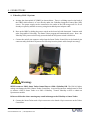
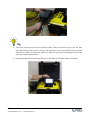
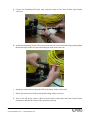
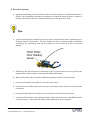
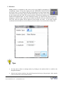
_____________________________________________ User Manual Software Version 6.3 _____________________________________________ Revision 1 KCF Technologies, Inc. 336 South Fraser St., State College, PA 16801 www.kcftech.com 814.867.4097 1. CONTENTS 1. Contents................................................................................................................................................2 2. Introduction........................................................................................................................................4 3. CareandHandlingoftheSmartTether...................................................................................4 4. Connections.........................................................................................................................................5 1. VideoRayPRO3System........................................................................................................................................5 2. VideoRayPRO4System......................................................................................................................................11 3. SmartTetherBasicSystem................................................................................................................................12 4. DiverNavSystem....................................................................................................................................................13 5. Pre‐DiveChecklist..........................................................................................................................15 6. ShuttingDown..................................................................................................................................15 7. BasicSoftwareOperation............................................................................................................16 8. GoogleEarth......................................................................................................................................18 9. AdvancedSoftwareFeatures.....................................................................................................21 1. ScanTools..................................................................................................................................................................21 2. Markers......................................................................................................................................................................22 3. ZoomandRotate....................................................................................................................................................23 4. Panning.......................................................................................................................................................................23 5. DepthReset...............................................................................................................................................................23 6. DataOutput...............................................................................................................................................................23 7. DataStorage.............................................................................................................................................................24 10. ToolsMenu....................................................................................................................................25 1. BaseMaps..................................................................................................................................................................25 KCF Technologies, Inc. | 814.867.4097 www.smarttether.com | [email protected] 2 2. Markers......................................................................................................................................................................26 3. Units.............................................................................................................................................................................27 4. GPS................................................................................................................................................................................28 5. TetherTending........................................................................................................................................................29 6. TetherConfiguration............................................................................................................................................29 7. CommunicationSettings.....................................................................................................................................30 8. FieldofView.............................................................................................................................................................30 9. Diagnostics................................................................................................................................................................30 11. PilotingandTendingTechniques........................................................................................31 1. ProperTechniques................................................................................................................................................31 2. TetherTendingModes.........................................................................................................................................34 12. SmartTetherBasic.....................................................................................................................37 13. AdditionalTips............................................................................................................................40 1. Extensiontethers...................................................................................................................................................40 2. UsingaPRO3SmartTetherwithaPRO4VideoRay.............................................................................40 14. SoftwareTroubleshooting......................................................................................................41 1. Communications.....................................................................................................................................................41 2. ErrorMessages........................................................................................................................................................42 15. Training/Certification............................................................................................................44 16. ServiceandSupport..................................................................................................................44 KCF Technologies, Inc. | 814.867.4097 www.smarttether.com | [email protected] 3 2. INTRODUCTION The Smart Tether is a revolutionary tether‐based underwater navigation technology in which all of the sensingelementsarehousedinthetetheritself.Thismakessetupveryquickandstraightforward,anda newusercaneasilybeupandrunninginamatterofminutes. It is recommended that a new user read through the Connections, Shutting Down, and Basic Software Operationsectionsbeforeattemptingamission.Withthatsmallamountofinformationyoushouldbeable togettheSmartTetherrunningandgetcomfortablewithitsoperation.Onceyouarefluentwithoperating theSmartTether,readontotheAdvancedSoftwareFeaturessectiontolearnaboutthefurthercapabilities oftheSmartTether. Withasmallbitoftrainingandonlyminormodificationtoyouroperatingandtethertendingtechniques, the Smart Tether is a powerful navigation and positioning tool which can add great value to your underwatermissions. While the Smart Tether is designed to be simple and require minimal training, there is some technique involvedinusingthesystem,andtrainingfromacertifiedinstructorcanbehighlybeneficialtonewusers. Toscheduletraining,pleasecontactKCFTechnologies. 3. CAREANDHANDLINGOFTHESMARTTETHER The Smart Tether is designed to stand up to your most demanding missions. Following a few simple guidelineswhilehandlingyourSmartTetherwillhelpensurethatitisnotdamaged. Avoid chafing or scraping the tether against rough or sharp surfaces, avoid stepping on the tether or placingheavyobjectsonit,andavoidbendingitinaverytightradiusorputtingkinksintothetether. Inadditiontothesecommon‐senseguidelines,additionalcareshouldbepaidtotheSmartTethersensor nodes. Donotsubjectthesensornodestohighbendingloads,forinstancebylettingthemgetpulledtaut overtheedgeofapier,rail,orboatdeck Donotsubjectthenodestoheavyloadsbysteppingorplacingheavyobjectsonthem Donotinsertsmallobjectsintothepressuresensorholeinthesensornodes.Iftheholebecomes encrustedwithsandorothermaterialandthepressurereadingbecomesincorrect,soakthenode infreshwaterandgentlyswishitbackandforthtofreetheforeignmaterial Avoidcoilingthetethersmallerthana16”diameter WhenwindingtheSmartTetherintoaVideoRayTetherDeploymentSystem(TDS)orothersmall‐diameter reel,theconnectorsandnodesshouldbelaidparalleltotheaxisofthereelastheyareputontothereel.If theyarewoundaround circumferentiallyliketherest ofthetether,they may experiencesevere bending loads and become damaged, or contact the inside of the Pelican case and get jammed. (Note: For the VideoRayPRO3SmartTether,aspecific12‐wireTDSisrequired) KCF Technologies, Inc. | 814.867.4097 www.smarttether.com | [email protected] 4 4. CONNECTIONS 1. VideoRayPRO3System a. Arrangetheultra‐mobilePC(UMPC)asshownbelow.Thereisafoldingstandonthebackof the UMPC which allows it to rest directly under the VideoRay Integrated Control Box (ICB) screen. The power supply can be connected to the outlet in the ICB storage well if it is not alreadyoccupiedbyanotheraccessory,usingtheincludedpoweradaptercable. b. BootuptheUMPCbyslidingthepowerswitchonthelowerleftsidedownward.Continuewith otherstepswhileitisbooting.TheSmartTetherprogramwillautomaticallyopen.Note:the VideoRayICB’spoweroutletisonlypoweredwhentheICBpowerswitchisturnedon. c. Connectthemale8‐pinconnectorwhipfromtheSmartTetherControlBoxtothefemale8‐pin connectorwhipfromtheICB(removetheICBwhipfromtheplasticcableclampifnecessary). Warning: NEVERconnectaPRO3SmartTetherControlBoxtoaPRO4VideoRayICB.ThePRO4’shigher voltagecandamagethePRO3SmartTetherControlBox.AspecialUpconvertermodulemustbeused to connect a PRO 3 Smart Tether to a PRO 4 VideoRay. Contact VideoRay or KCF to obtain an Upconvertermodule. FailuretofollowtheabovewarningmayresultindamagetotheVideoRayorSmartTether. d. ConnecttheSmartTethermale12‐pinconnectortothefemale12‐pinconnectorontheTether ControlBox. KCF Technologies, Inc. | 814.867.4097 www.smarttether.com | [email protected] 5 Tip: The12‐pinconnectorrequiresafirmpushtoinstall.Pushtheconnectorasfarasyoucan,then threadthelockingcollarasfarasyoucan,andrepeatuntilnoneofthethreadsonthebulkhead connectorarevisible.Ifthreadsarevisible,theconnectormaynotbefullyengagedandyoumay experienceconnectivityproblems. e. ConnecttheUSBcablefromthetopUSBportoftheUMPCtotheSmartTetherControlBox. KCF Technologies, Inc. | 814.867.4097 www.smarttether.com | [email protected] 6 Tip: ItcanbeusefultoruntheUSBcablebehindthestrutontheleftsideoftheICBtokeepittidy f. PulltheUSBGPSreceiveroutofthe ICB andplaceitnearwheretheSmartTetherentersthe water, using the USB extension cords if necessary. Connect the USB cable to the port on the rightsideoftheUMPC(behindtheflapdoor)ifnotalreadyconnected. Tips: TheGPSreceiverhasamagneticbase MovingtheGPSreceiverseveralfeetawayfromtheICBmayimprovesatellitereception TheSmartTetherwillworkwithoutaGPSreceiver.Ifareceiverisnotused,thesoftwarewilluse thebaselinecoordinatesenteredintheGPSmenu(seeSection10.4).Whenoperatingfromafixed launchpoint,toavoidGPSerrorordrift,usethe“LockGPSPosition”optionintheGPSmenu KCF Technologies, Inc. | 814.867.4097 www.smarttether.com | [email protected] 7 g. Connect the VideoRay ROV 8‐pin male connector whip to the Smart Tether 8‐pin female connector. h. InstalltheterminatingSmartTethersensornodeintotheclearfloatblockcapbygentlypulling thebottomedgesofthecapapartandslidingthenodeinfromtherear. i. AttachthestrainreliefwirefromtheROVtotheSmartTetherstrainrelief. j. Ensureallconnectorsarefullyinsertedandlockingcollarsaresecure. k. Turn on the ICB power switch. LEDs on Smart Tether Control Box and Smart Tether Nodes illuminatetoindicatetheSmartTethersystemispowered. KCF Technologies, Inc. | 814.867.4097 www.smarttether.com | [email protected] 8 Tip: IfSmartTetherControlBoxLEDisnotilluminated,turnoffICBpowerswitch,check(disconnect andreconnect)allconnections,andtryagain. Warnings: ALWAYSsecureallconnectionsBEFOREturningonICBpowerswitch ALWAYSturnoffICBpowerswitchBEFORElooseningordisconnectinganyconnectors FailuretofollowtheaboveproceduresmayresultindamagetotheVideoRayorSmartTether KCF Technologies, Inc. | 814.867.4097 www.smarttether.com | [email protected] 9 CompletedSystemSetup KCF Technologies, Inc. | 814.867.4097 www.smarttether.com | [email protected] 10 2. VideoRayPRO4System a. Simply connect the Smart Tether in place of your standard VideoRay tether between the RemotelyOperatedVehicle(ROV)andIntegratedControlbox(ICB). Warning: NEVERconnectaPRO3SmartTetherControlBoxtoaPRO4VideoRayICB.ThePRO4’shigher voltagecandamagethePRO3SmartTetherControlBox.AspecialUpconvertermodulemustbeused to connect a PRO 3 Smart Tether to a PRO 4 VideoRay. Contact VideoRay or KCF to obtain an Upconvertermodule. FailuretofollowtheabovewarningmayresultindamagetotheVideoRayorSmartTether. b. PulltheUSBGPSreceiveroutofthe ICB andplaceitnearwheretheSmartTetherentersthe water, using the USB extension cords if necessary. Connect the USB cable to a port on the computeroranaccessoryportintheICBifnotalreadyconnected. Tips: TheGPSreceiverhasamagneticbase MovingtheGPSreceiverseveralfeetawayfromtheICBmayimprovesatellitereception TheSmartTetherwillworkwithoutaGPSreceiver.Ifareceiverisnotused,thesoftwarewilluse thebaselinecoordinatesenteredintheGPSmenu(seeSection10.4).Whenoperatingfromafixed launchpoint,toavoidGPSerrorordrift,usethe“LockGPSPosition”optionintheGPSmenu c. AttachthestrainreliefwirefromtheROVtotheSmartTetherstrainrelief. d. Ensureallconnectorsarefullyinsertedandlockingcollarsaresecure. e. TurnontheICBpowerswitch.LEDsontheSmartTethernodesilluminatetoindicatetheSmart Tethersystemispowered. KCF Technologies, Inc. | 814.867.4097 www.smarttether.com | [email protected] 11 Warnings: ALWAYSsecureallconnectionsBEFOREturningonICBpowerswitch ALWAYSturnoffICBpowerswitchBEFORElooseningordisconnectinganyconnectors FailuretofollowtheaboveproceduresmayresultindamagetotheVideoRayorSmartTether CompletedSystemSetup 3. SmartTetherBasicSystem The Smart Tether software may be used in Basic mode with a VideoRay PRO 4 system without havingaSmartTether.ConnecttheROVasperVideoRayinstructions,andconnecttheGPSantenna asshownif desired(seesection 10.4).SeeSection12 forspecialinstructiononthe useofSmart TetherBasic. KCF Technologies, Inc. | 814.867.4097 www.smarttether.com | [email protected] 12 4. DiverNavSystem a. AttachtheterminatingnodeoftheSmartTethertothediver’smaskortoahand‐heldcameraor SONAR.Theterminatingnodemakesitpossibletoseewhichdirectionthediverorcamerais facingsothattopsidecrewcancommunicatedirectionstothedivermoreeasily. Tips: Iftheterminatingnodeisattachedtothediver’smask,itisadvisabletoattachitpointingupata 45‐degree angle as shown below. This way, whether the diver is walking upright or swimming horizontally, the terminating node will be pointing the correct direction to give an accurate heading. Additionally,thenodeshouldnotbeattachedtoapieceofferrousmetal,asthismaydisruptthe magnetometerreadingandgiveaninaccurateheadingmeasurement. b. MarrytheDiverNavcabletothediverumbilicalusingtapeorotherconvenientmeans. c. ConnecttheDiverNavControlBoxtoa120VACpowersource. d. ConnecttheSmartTethermale4‐pinconnectortothefemale4‐pinconnectorontheDiverNav ControlBox. e. ConnecttheUSBcablefromaUSBportonthecomputertotheDiverNavControlBox. f. LocatetheGPSandplaceitnearwheretheSmartTetherentersthewater,usingUSBextension cordsifnecessary.ConnecttheUSBcabletoandavailableportonthecomputer. KCF Technologies, Inc. | 814.867.4097 www.smarttether.com | [email protected] 13 Tips: TheGPSreceiverhasamagneticbase TheSmartTetherwillworkwithoutaGPSreceiver.Ifareceiverisnotused,thesoftwarewilluse thebaselinecoordinatesenteredintheGPSmenu(seeSection10.4).Whenoperatingfromafixed launchpoint,toavoidGPSerrorordrift,usethe“LockGPSPosition”optionintheGPSmenu g. Bootthecomputer,selectSmartTetherprogramfromtheWindowsdesktop. h. Turn on the DiverNav Control Box power switch. LEDs on Divernav Control Box and Smart TethernodesilluminatetoindicatetheSmartTethersystemispowered. CompletedSystemSetup KCF Technologies, Inc. | 814.867.4097 www.smarttether.com | [email protected] 14 5. PRE‐DIVECHECKLIST 1. Allsystemspoweredon 2. SmartTethersensornodeLEDslit 3. SmartTethersoftwareopenedandrunning(seesection4) 4. GPSfixacquired(ifusingGPS,seesections4and10.4) 5. Pressuresensorszeroed(seesection9.5) 6. SHUTTINGDOWN Whenshuttingdownandpackingupthesystem,theGPSreceiverandcablescanbestoredinsidethe VideoRayICB. 1. Pressthe“Stop”buttonintheSmartTetherSoftware 2. Close the Smart Tether software either by clicking the “X” button in the upper right corner or clicking “File Exit”. If you are ending your VideoRay Cockpit session, closing Cockpit will automaticallycloseSmartTether 3. TurnofftheVideoRayandSmartTetherviatheon/offswitchontheICB KCF Technologies, Inc. | 814.867.4097 www.smarttether.com | [email protected] 15 7. BASICSOFTWAREOPERATION BasicSystemLayout ThefollowingimageshowsatopviewofthegenerallayoutoftheSmartTethersystem.Bymeasuring theshapeofthetether,theSmartTethercalculatesthepositionoftheendofthetetherrelativetothe Base Point which is specified by the user in global coordinates, thereby generating both relative and absolute coordinates of the end point of the tether. Any tether that is between the Operator Station (whichcanbearbitrarilylocated)andtheBasePointisnotusedinthecalculation,andisconsidered inactive.ThetetherbetweentheBasePointandtheendpointisused,andisconsideredactive.See section7.3and10.5formoreinformationonhowtotendthetetherduringuse. TheSmartTethersoftwareisdesignedtobesimplefromauserperspective.Forbasicoperation,there areonlyafewbuttonsandfeatureswithwhichyouneedtobefamiliar.Theuserinterfaceisdesigned foratouch‐screencomputer,somostofthefeaturesneededduringnormaloperationareaccessibleby largebuttonsonthefrontpanelofthesoftwarethatcanbepushedwiththecomputer’sstylusoryour finger. This section details these basic functions and their operation. Sections 8 and 9 cover more advancedandspecializedfeaturesoftheSmartTethersoftware. ThemainplotontherightsideistheNavigationWindow,showingthetether’sshapeandposition.The blackdotattheoriginofthegraphrepresentstheBasePointthetetherisdeployedfrom(thiscanbe eitherafixedpointoramovingboat).Theyellowlinerepresentsthetether,andthesubsequentblack dotsindicatethepositionofthesensornodes.Thecurrentheadingoftheterminatingnodeisindicated bythearrowontheendofthetether. In theupperleftcorner ofthescreenisaside‐viewplotof thetethershape. Thisis aperpendicular projectionoftheoverallorientationofthetether.Thisplotcanbevaluableinshowingthedepthofthe various portions of the tether, and can help identify entanglements such as if the tether has been trappedunderneathanobstacle. KCF Technologies, Inc. | 814.867.4097 www.smarttether.com | [email protected] 16 Inthelowerleftcornerofthescreenisareadoutforthecurrentpositioninformation.Theendpoint’s 3Dcoordinatesareshown,aswellasrangeandbearingfromtheBasePoint. 1. Open the Smart Tether software by clicking the Smart Tether icon from the Windows Start menu. When operated with a VideoRay PRO 4 system, the software may be launchedfromtheVideoRayCockpitlaunchbar. 2. To begin navigating, press the “Operate” button (always make sure the Smart TetherandROVareturnedonfor5secondsbeforeOperatingtoallowthesensors tobootup). 3. AstheSmartTetheristendedandnodesenterorexitthewater, adjustthesoftware accordingly bypressing the gray“+” and“‐” buttons to maintain the correct number of nodes in the water (seeSection10.5and11.2). KCF Technologies, Inc. | 814.867.4097 www.smarttether.com | [email protected] 17 Tips: TheSmartTethersensornodesaremarkedwithbandsindicatingtheirnumber,i.e.thenumberof nodesinthewater,to helpwith thisoperation.Eachnarrowband( _)represents1,eachwide band(___)represents5.Forexampleifthelastnodetoenterthewaterismarked____,itindicates that6(5+1)nodesarebeingused. Usingextratether:Ifthe6thandfinalnodeisinthewaterbutmoretetherisstillneeded,youcan incrementtheSmartTethersoftwarein5‐foot(1‐meter)incrementsasyouaddmoretether.For thisreason,itisadvisableforthecustomertomarktheSmartTetherandanyextensiontethersin whatever way is most convenient for your application. Keep in mind there are 30 feet of tether pastnode6onthestandardSmartTether. Using the minimum amount of tether necessary to complete your mission helps to maximize the accuracy of the Smart Tether. Accuracy will be negatively affected by having large amounts of slack,unnecessarytetherinthewater.Apersontendingthetetherandinformingtheoperatorof howmanysensornodesareinthewaterismosthelpful. Seesection11formoredetailsonpilotingandtethertendingtechniquestomaximizetheaccuracy oftheSmartTether. P P 4. Toendtheoperation,pressthe“Stop”button. 8. GOOGLEEARTH TheSmartTethercandisplayyourscanhistoryandmarkersinGoogleEarth,givingyouasimplewayto geo‐referenceyourlocationrelativetoreallandmarks. 1. Any time you would like to view your markers and scan history in Google Earth, click the “View Map” button in the bottom right corner of the Smart Tether top viewplot. 2. GoogleEarthwillautomaticallylaunchifitisnotalreadyopen,andauto‐zoomtoyourlocationfor easyviewingofasnapshotofyourcurrentscanprogress. KCF Technologies, Inc. | 814.867.4097 www.smarttether.com | [email protected] 18 KCF Technologies, Inc. | 814.867.4097 www.smarttether.com | [email protected] 19 Tips: The Smart Tether Google Earth export makes compact KMZ‐format files which can easily be emailed or used as a concise summary of your mission. These files are saved in the folder “KCF Technologies\Smart Tether\KMZ Files” in the “Documents” folder (“My Documents” in Windows XP). A KMZ file is created whenever either the “View Map” or “Stop” button is pressed, ensuring you haveeasyaccesstotheresultsofeachoperation. ScanhistorysnapshotsexportedfromSmartTetherbecome“TemporaryPlaces”inGoogleEarth andcanbeviewedandmanipulatedinthetreeontheleftsideofGoogleEarthjustlikeanyother GoogleEarthobject.Youmayhideorshowindividualitemsbycheckingoruncheckingtheitemin thetree. TheSmartTetherGoogleEarthfeaturewillworkwithoutaninternetconnection,butnewsatellite imagery cannot be downloaded without an internet connection. Previously‐viewed satellite imagesareretainedinGoogleEarth’simagecacheuntilthecachefills.Thus,itisadvisabletolog on to the internet and view the target area at maximum zoom‐in in Google Earth before the operationsothataccuratesatelliteimagerywillbeavailableinthefieldduringtheoperation. KCF Technologies, Inc. | 814.867.4097 www.smarttether.com | [email protected] 20 9. ADVANCEDSOFTWAREFEATURES 1. ScanTools The Smart Tether software can show a representation of the area scanned by various imaging hardware you may be using underwater, such as a camera or SONAR held by a diver or mounted to an ROV. The scan tools buttons toggle betweenshowingonlythetether,showingthecurrentCameraorSONARfieldof view, or showing the Camera or SONAR scan history. A mode is selected by pressing either the Camera or SONAR button multiple times to toggle through eachoption. a. FieldofView A single cone shape indicates field of view mode. In field of view mode, the Smart Tethersoftwarewillshowyouthecurrentfieldofview. b. ScanHistory: Multipleconeshapesindicatescanhistorymode.Inscanhistorymode,theSmart Tether software will show you all the area that has been covered by either device duringthecurrentscan.Thiscanbehelpfulinensuringyouhavecoveredanentire scan area. The scan history colored area gets darker the longer you remain in an area, so an area that is lightly colored may have only been briefly scanned, while a darkly‐colored area indicates a more thorough inspection. The scan history will be cleared whenever the tether operationisstoppedandrestarted. KCF Technologies, Inc. | 814.867.4097 www.smarttether.com | [email protected] 21 2. Markers Adding markers or waypoints to the screen can be very helpful in navigating or reacquiringatarget.Atanytime,simplypressthe“AddMarker”buttonnearthe topofthescreen.Anewwindowwillpopupallowingyoutoentermarkerdata. Tomarkthecurrentlocation,simplyselectthemarkertypeyouprefer,enteratitle for the marker and click “OK”; the current location is already pre‐loaded in the latitude and longitudefields.Tomarkadifferentlocation,e.g.aknownGPSpointyou’dliketo navigate to, enter the title, replace the pre‐loaded coordinates with your desired location, and click “OK”, and the marker will be placed at the location you enter. If you enter invalid coordinatesthefieldwillturnredtoindicateyouneedtomakeacorrectionbeforeclicking“OK”. Tips: You may edit or delete an existing marker by clicking on the marker while it is visible in the NavigationWindow Push‐pinstylemarkersindicate themarkedlocationwiththe tipof thepush‐pin. Othermarker iconsarecenteredoverthemarkedlocation KCF Technologies, Inc. | 814.867.4097 www.smarttether.com | [email protected] 22 3. ZoomandRotate UsethecontrolintheupperrightcorneroftheNavigationWindowtozoom androtatethemap.Presstheplusbuttontozoominandtheminusbutton to zoom out. Press on the right side of the button to rotate the image clockwise and the left side to rotate the image counter‐clockwise. The currentmaprotationangleisdisplayedinthelowerright. Tips: Press and release quickly for small zoom/rotate changes or hold the buttons down for a continuouszoom/rotate Whenzoomingwithscanhistoryenabled,itmaybecomenecessaryfortheSmartTethersoftware toredrawthescanhistoryinordertodisplayitclearly.Theremaybeaslightflickerasthehistory isredrawn 4. Panning Bydefault,theBasePointoftheSmartTetheriscenteredinthemiddleoftheNavigationWindow. The Base Point can be moved, if desired, by clicking on the Navigation Window and dragging the BasePointtothenewdesiredlocation.TheSmartTethersoftwarewillnotallowtheBasePointto leavethewindowtoensurethatthetetherisalwaysvisible. 5. DepthReset Overtime,thepressuresensorsmaygetslightlyoutofcalibration.Ifthishappens, remove the entire Smart Tether from the water and press the “Reset Depth” button, and click “Yes” to confirm the Smart Tether is out of the water (at atmospheric pressure). As a pre‐dive check, it is a good idea to Reset Depth before putting the Smart Tether in the water to ensure all sensors are zeroed (this calibration is not performed automaticallyatstartup,sothatifpowerisinterruptedwhilethetetherisatdepth,thecalibration isnotlost). 6. DataOutput SmartTetherpositiondatacanbeexportedtodifferenthardwareorsoftwareviaserialconnection, eitherthroughaphysicalportorthroughthird‐partyvirtualportsoftware.Dataisexportedasa NMEA GPGGA string. This data can be useful for incorporating Smart Tether data into other mapping or mission management software, or for overlay in other software, such as SONAR or video displays. See Section 10.7 for instructions on how to configure the output. To set up a KCF Technologies, Inc. | 814.867.4097 www.smarttether.com | [email protected] 23 connectionbetweenseparatesoftwareapplicationsonthesamecomputer,useathird‐partyvirtual COMportsoftwaretosetupvirtualportsandthenselectoneofthoseportsinthepull‐downmenu. 7. DataStorage AnytimetheSmartTethersoftwareisoperating,allavailabledataisbeingstoredtotheharddrive. Allrawdataisstoredbydefaultinthe folder“KCF Technologies\Smart Tether\DataFiles”inthe “Documents” folder (“My Documents” in Windows XP). This data is stored in .csv format and contains, among other data, GPS location of the Base Point and end point in a NMEA standard GPGGAformat.Thefirstlinewithinthesedatafilescontainsaheaderthatexplainsthemeaningof eachfield. KCF Technologies, Inc. | 814.867.4097 www.smarttether.com | [email protected] 24 10. TOOLSMENU Anumberofuseful,butlesscriticalfeaturesareavailableviathetoolsmenu. 1. BaseMaps This feature allows a nautical chart or other image to be placed in the background of the Smart Tether Navigation Window, making it possible to continually geo‐reference the Smart Tether’s positionandtethershapedatainrealtime. Smart Tether software will scan the folder “KCF Technologies\Maps” in the “Documents” folder (“MyDocuments”inWindowsXP)forrasterbasedimagery.Whilescanning,aprogressbarwillbe visibleinthelowerright‐handcornerofthescreen.Oncescanningcompletes,anyvalidchartsor images found will be displayed in the left side of the window order by distance from current location. If a map is visible from the current operating location, it will be marked with a star as shownabove. a. Loadingabasemap Selectthefilenamefromthelistbyclickingonthedesiredmap ClickontheLoadbutton TheimagewillloadwithintheNavigationWindow KCF Technologies, Inc. | 814.867.4097 www.smarttether.com | [email protected] 25 b. Clearingthebasemap ToclearthebasemapfromtheNavigationWindow,presstheClearbuttonfromwithinthe BaseMapswindow. Tips: Makesuretheselectedmaphasastarbyitsname.Ifthereisnostar,verifythattheGPShasafix orthecorrectBasepointisenteredintotheSmartTethersoftware(SeeSection10.4) Ifamapdoesn’tshowupinthelistasexpected,verifythatitisproperlylocatedwithinthefolder KCFTechnologies\Mapsinthe“Documents”folder(“MyDocuments”inWindowsXP).Ifitisinthe correctlocation,itmaybeinaformatincompatiblewiththeSmartTethersoftware Smart Tether software can read most raster based charts and images. These are normal images that have been geo‐referenced and contain information regarding their geographic location. Depending on the image format, sometimes the geographic information is contained within the imagefileitself,orsometimesadditional,companionfileswillberequired. Rasterbasedchartsmaybeobtainedorcreatedfromseveralsources.IntheUnitedStatesraster‐ basednavigationalchartsarefreelyavailableforallnavigablewaters.Thesemaybedownloaded, free of charge from the NOAA website at: http://www.charts.noaa.gov/RNCs/RNCs.shtml. These chartsmaybedownloadedforindividualregions,states,ortheentirecountry. Rasterbasedsatelliteimagerymayalsobepurchasedfromcommercialvendors.Thereareseveral reputablevendorswhichcanbefoundontheinternet. Rasterbasedimagesmayalsobeobtainedfrom Google Earthusing free thirdpartysoftwarelike Shape2Earth, a plug‐in for the open source GIS software MapWindow. (http://shape2earth.com/default.aspx)ThesetoolsallowyoutoexportimagesfromGoogleEarth and save them in a geo‐referenced, raster based format. Please make sure to check with Google Earth’stermsofuseastheirsatelliteimagerymaynotbefreetouseforallpurposes. 2. Markers a. SaveMarkers Markersmaybesavedatanytimeduringanoperation.Youwillbepromptedforalocationto savethemarkerstoo.TheywillbesavedtoastandardKMZfileformatandmaybeopenedin GoogleEarthforviewing.MarkerswillalsobeautomaticallybesavedtoaKMZfilewhenthe Stopbuttonispressedtoendtheoperation.Theseautomaticallygeneratedfilesarestoredin KCF Technologies, Inc. | 814.867.4097 www.smarttether.com | [email protected] 26 KCF Technologies\Smart Tether\KMZ Files in the “Documents” folder (“My Documents” in WindowsXP). b. RecallMarkers Use this function to recall markers from previously‐saved files. This can be very useful in resuming a scan from an earlier operation, or if you operate in the same area frequently and have various features marked to establish a reference frame for the region. You will be promptedtoselectthefiletorecall. c. ClearMarkers ThiswilldeleteallthemarkersfromtheNavigationWindow. 3. Units Change the on‐screen display of the latitude and longitudecoordinatesandmeasurementunitstosuit yourpreference. KCF Technologies, Inc. | 814.867.4097 www.smarttether.com | [email protected] 27 4. GPS To enable GPS functionality, check the “Enable GPS” checkbox. Smart Tether will then display a list of available GPS devices as well as an “Auto” option. Selecting “Auto” will cause the software to automatically connect to the first GPS device that it detects. If multiple GPS devices are present on the system, select the desired device from the list. Alternately, if no GPS is present, uncheck the “Enable GPS” box and enter your current location in the BasepointCoordinatesboxthatwillappear. Tips: Checkingthe“LockGPSPosition”checkboxwillcausethesoftwaretomonitortheGPSreadingfor 30seconds,determinetheaveragelocationbasedonthelast30secondsandlocktheBasePointto the calculated position. This can be very useful when operating from a fixed location as it will prevent normal GPS drift from affecting operation. When operating from a moving vessel, leave theGPSpositionunlocked. IfnoGPSisused,itisimportantthatthe“EnableGPS”boxisuncheckedandareasonablelocation is entered into the Basepoint Coordinates. Try to make sure that, at most, the Baseline Coordinates are no more than 100 miles (160 kilometers) from the operating location. Smart Tether software automatically compensates for variations in the earth’s magnetic field by using thelocationfromeithertheGPSortheBaselineCoordinates.IfnoGPSisusedandtheBaseline Coordinatesaresignificantlywrong,positionaccuracymaysuffer. KCF Technologies, Inc. | 814.867.4097 www.smarttether.com | [email protected] 28 5. TetherTending Selectthetethertendingmode.Thisisthemethod by which the Smart Tether software tracks the amount of tether that has been deployed. See Section 11.2 for more information on the different options. 6. TetherConfiguration Select the type of tether that will be used. Only choose Custom if you have a custom tether and havereceivedacustomtetherconfigurationfilefor yourtether. For DiverNav systems, up to three individual tethersmaybeconnectedinseries.Eachtetheris marked with a specific color. Select the color of each tether segment from the drop down lists, making sure that they are shown in the correct orderbetweenthediverandcomputer.Whenless thanthreetethersegmentsareused,select“None” from the corresponding list. The example at right showsasystemwithasinglegreentether. At the bottom of the screen are advanced settings whichshouldn’tnormallybechanged. KCF Technologies, Inc. | 814.867.4097 www.smarttether.com | [email protected] 29 7. CommunicationSettings Communicationsettingsareadjustedonthisscreen.For VideoRay PRO 3 or DiverNav systems, the correct port willbeindicatedwithan*.ForaVideoRayPRO4system, theSmartTetherportshouldalwaysbesettoCOM16.If “Enable Real‐time Output” is checked, Smart Tether will outputthecurrentROVpositiontotheserialportthatis selected from the list. This output will be in standard NMEAformatandwillappearasastandardGPSdevice. 8. FieldofView Change the angle and distance of the Camera and SONAR unit’sfieldofview.Usethisfeaturetoadjustthesizeofthe view cone to accurately represent the equipment you are using,sothatyougetarealisticrepresentationofthearea coveredduringascan. 9. Diagnostics This menu is primarily used to diagnose and troubleshoot issues with the physical Smart Tether hardwareandshouldnotberequiredundernormaloperatingconditions. KCF Technologies, Inc. | 814.867.4097 www.smarttether.com | [email protected] 30 11. PILOTINGANDTENDINGTECHNIQUES 1. ProperTechniques TheSmartTetherchangesyourunderwatertetherfrombeingsimplyanecessaryumbilicalintobeinga valuable measurement tool. As with any tool, good technique is required to obtain the best possible results.Thefollowingaresomebasictipsonhowtoperformyourunderwateroperationsinorderto improvetheaccuracyoftheSmartTetherpositioncalculation.Bybeingmindfulofthegenerallayout of your tether, not only will you increase the accuracy of the Smart Tether, you will also help avoid time‐consumingtetherentanglements. The Smart Tether software uses an intelligent curve‐fitting algorithm to determine the tether shape basedonthediscreteorientationdatacollectedfromthesensornodes.Inordertomaintainreasonable accuracy in a wide variety of tether configurations, the algorithm takes into account certain assumptionsabouthowthetethershouldbehandled.Whentheseassumptionsareviolatedbydriving thetetherinanunusualconfiguration,thepositionaccuracyoftheSmartTethersuffers. Ingeneral,usingtheminimumamountoftethernecessarytocompleteyourmissionhelpstomaximize theaccuracyoftheSmartTether.AccuracyisalsohelpedbykeepingtheSmartTetherinastraightline or large, sweeping curves. Accuracy will be negatively affected by having large amounts of slack, unnecessarytetherinthewaterorhavingalotoftightzig‐zagsorcoilsinthetether.Apersontending thetetherandinformingtheoperatorofhowmanytethernodesareinthewaterismosthelpful. Also,thediver,ROVpilot,and/ortethertendershouldavoidallowingalotofcurvatureinthetether betweenthelaunchpointandthefirstSmartTethernodeinthewater.Thefirstnodeshouldbasically point directly away from the launch point. Similarly, when using the Smart Tether Extension, the extensionshouldgoroughlyinastraightlineawayfromthelaunchpointtowardtheareaofoperation. Itshouldnotgooffalongdistanceinanotherdirectionandthendoubleback. ThefollowingtableillustratessomeexamplesituationsthatwouldreducetheSmartTether’saccuracy, andprovidesimprovedalternativetechniques. Tips: ThesetechniquesapplytothefullSmartTethersystem.ForSmartTetherBasicseeSection12 KCF Technologies, Inc. | 814.867.4097 www.smarttether.com | [email protected] 31 BAD OPERATION BAD SOFTWARE RESULT GOOD OPERATION X SmartTethersoftwareassumes moregentlecurvesandplotsend pointtoofaraway.Thisis exaggeratedifnodeshappento begenerallyaligned,as illustrated Tetherhasseveralzig‐zagsand tightcurves Uselesstether(fewersensor nodes)andoperateinamore gentlecurve X SmartTetherExtensionnot extendedingeneraldirectionof firstSmartTethernode SmartTethersoftwareassumes smoothcurvefromfirstSmart Tethernodetolaunchpoint KCF Technologies, Inc. | 814.867.4097 www.smarttether.com | [email protected] UselesstetherandkeepSmart TetherExtensioninlinewith beginningofSmartTether 32 X SmartTethersoftwareassumes smoothcurvefromfirstSmart Tethernodetolaunchpointand causesalargepositionerror SmartTetherExtension stretchedoutinonedirection, SmartTetherdoubledback,e.g. forapierinspection Uselesstether(fewersensor nodes)andoperateinamore gentlecurve A large rectangular pattern will require constant tether tending to avoidthe“doublingback”situation shown above, and will result in poor accuracy and low confidence that the area has been completely covered. X Rectangularscanpatternfrom fixedpoint Usinganarcpatterninsteadmeans thetetheronlyneedstobetended occasionally,andthetethercanbe kept virtually straight, giving excellentaccuracy.Anarcpattern also allows more area to be covered with the same tether length. Arcscanpatternfromfixedpoint KCF Technologies, Inc. | 814.867.4097 www.smarttether.com | [email protected] 33 2. TetherTendingModes TheSmartTethersoftwaremustcorrectlytrackthelengthoftetherthatisinthewaterinorderto make accurate measurements. This can be accomplished by either manually indicating to the softwarethelengthoftetherthatisinthewaterorbyusinganautomaticcounterliketheTether Tender. a. ManualTender Manualtethertendingcanbedoneusingoneofthefollowingthreeoptions: NodeIncrementOnly InNodeIncrementOnlymode,thesoftwaretracksthenumberofnodesinthewater.Each timeanodeonthetetherisdeployedorretrieved,the“+”or“‐“buttonmustbepressedto indicatethenumberofnodesinthewater. NodeIncrementPlusLength In Node Increment Plus Length, the software tracks both the number of nodes plus the lengthoftetherbeyondthehighestactivenode.Whenanodeisdeployedorretrieved,use the upper “+” and “‐“ buttons to indicate the number of nodes in the water. Additionally, whenmoreorlesstetherisdeployedbeyondthenode,usethelower“+”and“‐“buttonsto indicatethelengthofadditionaltetherthatisinthewater.Thismethodwillgenerallybe themostaccurateoftheManualTendermodes. LengthOnly InLengthOnlymode,thesoftwaretracksthelengthoftetherinthewater.Whenevertether is deployed or retrieved, the “+” or “‐“ button must be pressed to maintain the correspondinglengthoftetherthatisinthewater.Dependingontheunitsofmeasure,each pressofthebuttonincrementsthedeployedlengthby5feetor1meter. KCF Technologies, Inc. | 814.867.4097 www.smarttether.com | [email protected] 34 b. AutoTender InAutoTendermode,SmartTetherattemptstodetermine which nodes are in the water by monitoring the pressure reportedateachnode. In the Auto Tender setup, there are two values which can be adjusted. The “Deployed Depth” value determines the depth at which Smart Tether determines that the node is nowdeployedinthewater.The“RetractedDepth”valuedeterminesthedepthatwhichSmart Tetherdeterminesthatadeployednodehasbeenretractedfromthewater. Tips: BesurethattheDeployeddepthisgreaterthantheRetracteddepth SmartTethernodescansensevariationsindepthofroughly6”(0.15m).Makesurethatthereisat least6”(0.15m)betweenthedeployedandretractedvalues Typicalvalueswillbeadeployeddepthof2’(0.6m)andaretracteddepthof1’(0.3m) c. TetherTender TheTetherTenderisacounterthatautomaticallytracksthelengthoftetherthatisdeployed intothewater.ThisismoreaccuratethantheManualTenderoptionsandrelievestheoperator fromhavingtoconstantlymonitortetherlength. UsethefollowingstepstousetheTetherTender: ConnectaUSBcablebetweentheTetherTenderandthecomputer Select Tether Tender from the Tether Tending menu(SeeSection10.5)andpressOK From the main window, the tether tending area shouldshow“TetherTender”withalengthof0 Place the second node on the wheel of the tether tender and press the button “Reset To Node 2”. This will reset the length to reflect the length of tetherbetweenthe2ndnodeandtheendpoint RunthetetherthroughtheTetherTenderandseethatthelengthchangesinthewindow KCF Technologies, Inc. | 814.867.4097 www.smarttether.com | [email protected] 35 Tips: Ifitismoreconvenienttoresetthelengthtoanodeotherthannode2,gototheTools>Tether TendingmenuandselectthedesirednodefromthelistundertheTetherTendersection.Thiscan beusefulifaresetneedstobedoneduringanoperationwiththetetheralreadydeployed.(See Section10.5) OnPRO3andPRO4systems,node2isthefirstnodeaftertheROV KCF Technologies, Inc. | 814.867.4097 www.smarttether.com | [email protected] 36 12. SMARTTETHERBASIC Smart Tether Basic is an introductory mapping and location marking tool that can be used to supplementaPRO4ROVwithouttheuseoftheSmartTetherhardware.SmartTetherBasicusesthe standardSmartTetherorientationboardinstalledintheVideoRayPro4ROV,theROV’sdepthsensor, andtheextendedtetherlengthtoapproximatethelocationoftheROVbydrawingastraightlinefrom thebasepointtotheROV. Thismethodofapproximationhassignificantlimitationsforaccuratepositioningpurposes,butifthe limitations are understood and the ROV is correctly operated, it can be very useful for mapping and marking approximate locations. Smart Tether Basic is also ideal for accurately tracking the base location, maintaining a geo‐referenced situational awareness during an operation, and documenting results. KCF Technologies, Inc. | 814.867.4097 www.smarttether.com | [email protected] 37 Tips: WithoutthecompleteSmartTetherhardware,SmartTetherBasicprovidesonlyaroughestimate oftheROVlocation.Thisestimatecanbeaffectedbymanyfactors(tethertension,waveaction, etc.)thatSmartTetherBasicwillnotbeabletocompensatefor. For accurate positioning, consider purchasing the complete Smart Tether hardware and upgrading to the full Smart Tether software. A full Smart Tether system, complete with Smart Tetherhardwarecanprovidepositioningaccuracyof+/‐2%ofthetetherlength. TheSmartTetherBasicsoftwarecomeswithallthefeaturesofthestandardSmartTethersystem.This includesmarkers,backgroundmaps,kmzoutputs,etc. TheonlylimitationstotheSmartTetherBasicsoftwarearethefollowing: a. TheonlyoptionintheTetherConfigurationwindowisPro4Basic.(seeSection10.6) b. Tether tending options are limited to Length Only or using the Tether Tender. (see Section 10.5) DuetothelimitationofonlyusingtheorientationsensorintheROV,SmartTetherBasicmakescertain assumptionswhenestimatingROVlocation.Thetwokeyassumptionsare: a. Therearenocurvesorbendsinthetether.Thesoftwareassumesthetetherisinastraightline fromthebasepointtotheROV. b. TheROVisorientedawayfromthebasepoint. To achieve the most reliable estimates of location when using Smart Tether Basic, it is important to reduce or eliminate slack in the tether and point the ROV away from the base point. Use the illustrationsbelowasaguide. KCF Technologies, Inc. | 814.867.4097 www.smarttether.com | [email protected] 38 BAD OPERATION BAD SOFTWARE RESULT GOOD OPERATION X SmartTetherBasicassumesthe tetherisstraight.ROVwillbe incorrectlylocated. ROVisnotorientedawayfrom thebasepoint Keepthetetherstraightandthe ROVorientedawayfromthebase pointformoreaccuratelocation estimates X Toomuchslackinthetether SmartTetherBasicassumesthat therearenocurvesinthetether. TheROVisincorrectlylocated furtherfromthebasepointthan itactuallyis. Keepthetetherstraightandthe ROVorientedawayfromthebase pointformoreaccuratelocation estimates KCF Technologies, Inc. | 814.867.4097 www.smarttether.com | [email protected] 39 13. ADDITIONALTIPS 1. Extensiontethers ThePRO4SmartTetherutilizessimilarconstructiontoVideoRay’sPPTtether,soVideoRaytethers canbeusedasextensionsbetweentheSmartTetherandtheVideoRayICB.Itisnotrecommended touseaVideoRayPPTtetherasanextensionfortheSmartTether,asthethinwirediametermay resultinreducedvoltageandpoorROVperformance. 2. UsingaPRO3SmartTetherwithaPRO4VideoRay IfyoupreviouslypurchasedaPRO3SmartTetherandareupgradingtoaPRO4ROV,youcanstill use your PRO 3 Smart Tether. Please contact your VideoRay dealer to purchase an Upconverter modulewhichwilladaptthe12‐pinPRO3SmartTethertoyournew8‐pinPRO4hardware. Warning: NEVERconnectaPRO3SmartTetherControlBoxtoaPRO4VideoRayICB.ThePRO4’shigher voltagecandamagethePRO3SmartTetherControlBox.AspecialUpconvertermodulemustbeused to connect a PRO 3 Smart Tether to a PRO 4 VideoRay. Contact VideoRay or KCF to obtain an Upconvertermodule. FailuretofollowtheabovewarningmayresultindamagetotheVideoRayorSmartTether KCF Technologies, Inc. | 814.867.4097 www.smarttether.com | [email protected] 40 14. SOFTWARETROUBLESHOOTING 1. Communications IftheSmartTetherexperiencescommunicationsproblemsandbeginstogiveerrormessages,the followingbasictroubleshootingproceduresshouldrectifytheproblem. 1. Press“Stop”intheSmartTethersoftware 2. ClosetheSmartTetherSoftware 3. TurnofftheICB 4. Check(disconnectandreconnect)allconnections:SmartTethertoROV,SmartTethertoICB, andUSBcablefromICBtoToughbook 5. TurntheICBbackonandwait5seconds.Retrysoftwareoperation 6. Ifproblemsstillpersist,checkthattheSmartTetherandGPS(ifinstalled)areassignedtothe correctCOMport. TheCOMportsspecifiedinthe Toolsmenu(seesection10.7)mustmatch the COM ports found in the Windows Device manager (accessed by clicking Start Control PanelSystemHardwareDeviceManagerPorts(COM&LPT) a. The “Sealevel RS485” device is the Smart Tether COM port and the “Prolific USB‐to‐ SerialCommPort”deviceistheGPSCOMport b. TochangeCOMports,double‐clickthedeviceunderPorts(COM&LPT),thenselectPort SettingsAdvanced,andchangetheCOMPortNumberinthedrop‐downmenu.Click OK if a warning appears about port sharing, then click OK to apply the changes and returntotheDeviceManager 7. RetrytheSmartTetherSoftware 8. If the above steps do not solve the problem, shut down and restart the Toughbook and ICB beforetryingagain KCF Technologies, Inc. | 814.867.4097 www.smarttether.com | [email protected] 41 2. ErrorMessages a. ErrorconnectingtotheSmartTether ThefollowingerrormessageindicatesaproblemwiththeCOMportsetup: PossibleCauses: USB cable not connected from Smart Tether Control Box to computer (solution: check cable connection) COMportinGeneralSettingsmenudoesnotmatchCOMportinstalledinDeviceManager(solution: checkCOMportconfiguration,seeItem6above) VideoRayPRO4Only:Virtualportsnotassignedcorrectly:Apairofvirtualportsmustbeassigned tohandlecommunicationbetweenCockpitandSmartTether.Forinstance,assignports15and16 as a pair, then assign 15 in the VideoRay Cockpit configuration file and 16 in the Smart Tether GeneralSettings(callVideoRayforassistance) USBcabledamaged(solution:tryadifferentUSBcable) DamagedSmartTetherControlBox(solution:callVideoRayorKCF) KCF Technologies, Inc. | 814.867.4097 www.smarttether.com | [email protected] 42 b. Thefollowingnodesarenotresponding ThefollowingerrormessageindicatesaproblemwiththeSmartTethercommunication: Thiserrormeansthatthesoftwarewasunabletocommunicateproperlytooneormorenodeson thetether.Thismayindicateaninstantaneouscommunicationglitchwhichwillclearuponitsown, oritmayindicateanactualproblem.Whenthisoccurs,theaffectednodeswillbedisabledandwill nolongeroperateandtetheraccuracywillbeaffected.Tore‐enableanode,eitherpressthestop buttonandthenrestarttetheroperationsorenablethenodeintheTools>Diagnosticsmenu. PossibleCauses: SmartTethernotconnectedtoICB(solution:checkconnection) SmartTethernotturnedon(solution:checkallconnectionsandturnonpowerswitch) DamagedSmartTether(solution:callVideoRayorKCF) VideoRay PRO 4 Only: Virtual ports not assigned correctly: A pair of virtual ports must be assignedtohandlecommunicationbetweenCockpitandSmartTether.Forinstance,assignports 15and16asapair,thenassign15intheVideoRayCockpitconfigurationfileand16intheSmart TetherGeneralSettings(callVideoRayforassistance) CorruptedVideoRayCockpitConfigurationFile(solution:callVideoRay) CorruptedSmartTetherConfigurationfile(solution:callVideoRayorKCF) KCF Technologies, Inc. | 814.867.4097 www.smarttether.com | [email protected] 43 15. TRAINING/CERTIFICATION TheSmartTetherisdesignedtobesimpleanduser‐friendly,allowingnewuserstoquicklygetupand running.Manyuserswillbeabletooperatethesystemadequatelywithnotraining.However,aswith any task or system, it can be highly beneficial to receive training from an expert. KCF offers an intensive full‐day Certification Training program which covers everything from basic operation to advanced techniques. This course can improve your organization’s navigational capabilities and add valuetoyourSmartTetherandVideoRaysystem. To learn more about KCF’s Smart Tether Certification Training, contact KCF at 814.867.4097 or [email protected]. 16. SERVICEANDSUPPORT KCFoffersaServiceandSupportagreementforrepairorreplacementofyourSmartTetherequipment intheeventofdamageormalfunction.TheServiceandSupportagreementalsoentitlesyoutocertain upgradestotheSmartTethersoftware,aswellasprioritytechnicalsupport. TolearnmoreaboutKCF’sSmartTetherServiceandSupportprogram,contactKCFat814.867.4097or [email protected]. KCF Technologies, Inc. | 814.867.4097 www.smarttether.com | [email protected] 44


![Intergraph Geomedia [6.1-2013] User manual](http://vs1.manualzilla.com/store/data/005689587_1-58c82d14f3ba8ebe92b5c45af00d079c-150x150.png)