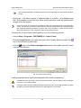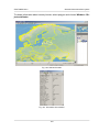
1
Digital Photogrammetric System
Version 6.0.2
USER MANUAL
General information about
system
General information about system
PHOTOMOD 6.0.2
Table of Contents
1. About ....................................................................................................................................... 4
1.1. Purpose of the document ............................................................................................... 4
1.2. Set of documentation ..................................................................................................... 4
1.3. Help .............................................................................................................................. 5
1.4. Abbreviations and acronyms .......................................................................................... 6
1.5. Main conventions and terms ........................................................................................... 7
1.6. The table of symbols .................................................................................................... 10
1.7. About Racurs company ................................................................................................ 10
1.8. Technical Support ........................................................................................................ 11
2. About system ......................................................................................................................... 12
2.1. Purpose of the system .................................................................................................. 12
2.2. Brief description of system features ............................................................................... 12
3. Logical structure of the system ................................................................................................ 13
3.1. Workflow of project processing ..................................................................................... 13
3.2. Brief description of modules and additional programs ..................................................... 14
3.3. Input and output data ................................................................................................... 16
3.3.1. Input data ......................................................................................................... 16
3.3.2. Output data ...................................................................................................... 18
4. Hardware requirements ........................................................................................................... 19
5. Delivery Set ........................................................................................................................... 20
5.1. Distribution kit .............................................................................................................. 20
5.2. Protection of the system ............................................................................................... 21
5.3. System installation ....................................................................................................... 22
6. Tools for work in stereo ........................................................................................................... 25
6.1. Graphic cards .............................................................................................................. 25
6.1.1. General information ........................................................................................... 25
6.1.2. Videoadapter driver settings for reflex monitors ................................................... 31
6.1.3. Videoadapter driver settings .............................................................................. 34
6.2. Using of special mice, hand wheels and foot pedals in the system .................................. 37
6.2.1. Setup of mouse driver ....................................................................................... 37
6.2.2. Mouse configuration .......................................................................................... 39
6.2.3. Macro editor ..................................................................................................... 47
7. Interface and its elements ....................................................................................................... 49
7.1. Work area interface ...................................................................................................... 49
7.2. The main system toolbar .............................................................................................. 51
7.3. Brief description of system menus ................................................................................. 53
8. General system’s windows ...................................................................................................... 54
8.1. ’ Windows’ menu ......................................................................................................... 54
8.2. 2D-window .................................................................................................................. 55
8.2.1. General information ........................................................................................... 55
8.2.2. 2D-window toolbar ............................................................................................ 56
8.2.3. Image scaling in 2D-window .............................................................................. 57
8.2.4. Stereopair 2D-window ....................................................................................... 57
8.2.5. Brightness and contrast settings ........................................................................ 60
8.2.6. Layer manager ................................................................................................. 61
8.2.7. Save scene in 2D-window .................................................................................. 65
8.2.8. Layer view mask ............................................................................................... 67
8.3. 3D-window .................................................................................................................. 68
8.3.1. 3D-window toolbar ............................................................................................ 68
8.3.2. Process in 3D-window ....................................................................................... 70
8.3.3. 3D-window parameters ...................................................................................... 71
9. Prepare to processing ............................................................................................................. 73
9.1. Data storing ................................................................................................................. 73
2
General information about system
PHOTOMOD 6.0.2
9.1.1. Main definitions of resources system .................................................................. 73
9.1.2. Profiles and virtual folders .................................................................................. 73
9.1.3. Storages ........................................................................................................... 74
9.2. Profiles ........................................................................................................................ 75
9.2.1. Control Panel Profiles management ................................................................... 75
9.2.2. Creating active profile ........................................................................................ 78
9.2.3. Connect virtual folder ........................................................................................ 80
9.2.4. Creating network profile ..................................................................................... 83
9.3. Processing setup ......................................................................................................... 85
9.3.1. Local processing ............................................................................................... 85
9.3.2. Network processing ........................................................................................... 85
9.4. PHOTOMOD Explorer module Resources management ................................................. 89
9.5. System Monitor service module .................................................................................... 92
10. Raster Converter source images preparing ............................................................................. 93
10.1. Raster images convertation ........................................................................................ 93
10.2. Radiometric correction .............................................................................................. 102
10.3. Prepare scanner images ........................................................................................... 112
10.3.1. Adding scanner images ................................................................................. 112
10.3.2. Detailed properties of adding scanner images ................................................. 115
10.4. Printing images ........................................................................................................ 118
11. Pan-sharpening .................................................................................................................. 121
11.1. The pan-sharpening operation ................................................................................... 121
11.2. Parameters of pan-sharpening .................................................................................. 125
12. Distributed Processing ........................................................................................................ 130
12.1. General Information .................................................................................................. 130
12.2. Workflow of distributed processing ............................................................................ 132
12.3. Distributed processing parameters setup ................................................................... 133
12.4. Distributed processing management .......................................................................... 136
12.5. Test of distributed processing .................................................................................... 139
13. Additional features of the system ......................................................................................... 140
13.1. ’Service’ menu ......................................................................................................... 140
13.2. Editing of active layer ............................................................................................... 141
13.3. Editing of active layer ............................................................................................... 142
13.4. Objects selection modes ........................................................................................... 143
13.5. Coordinate systems builder ....................................................................................... 144
13.5.1. Choosing of coordinate system ...................................................................... 144
13.5.2. Creating reference system ............................................................................. 145
13.6. Loading atlas ........................................................................................................... 148
13.7. CSV converter ......................................................................................................... 151
13.8. Customize hotkeys ................................................................................................... 158
Appendix A. Format and path of project files .............................................................................. 160
Appendix B. The PHOTOMOD 6.VAR configuration folder ........................................................... 161
3
General information about system
PHOTOMOD 6.0.2
1. About
1.1. Purpose of the document
This document contains detailed information about features of the PHOTOMOD system.
This document contains general information about system, instructions for installing
and setting up, and also preparing to work with the system. There are hardware requirements, projects workflow and brief description of modules and additional programs. It
describes work with additional tools for work in stereo mode, features of distributed
processing and also setting up of hotkeys.
1.2. Set of documentation
Besides this document there are user manuals in the set of documentation. These user
manuals contain instructions of different processes while working in the system.
Table 1. Full set of documentation for the system
Document
Function
Index
the list of user manuals and their correspondence
to system modules and programs
General information about system
this documents which contains detailed information
about system capabilities
GeoCalculator program
description of program to recalculate geodetic coordinates of points from one coordinate system to
another and also to create and edit coordinate systems or its parameters
General system’s parameters
description of the Parameters window which allows
to setup general system’s parameters
Project creation
description of project creation stage: adding of images in a project, their radiometric correction, forming and editing of images block, manage of images
in the system
Aerial triangulation
description of aerial triangulation stage, includes
interior orientation of block images, measurement
of tie points coordinates on images, relative orientation of block images, as well as input of ground
control points (GCP) coordinates to catalogue and
measurement of these points coordinates images
or their import and using exterior orientation data
Block adjustment
description of block adjustment stage: features of
central projection and satellite scanner imagery
blocks adjustment, adjustment accuracy control
Project processing
description of project processing stage – vectorization: processing of vector layers with/without classifier, features of creating and editing of vector layers,
topology verifying and also import/export of vector
objects
4
General information about system
PHOTOMOD 6.0.2
Document
Function
DEM Generation
description of project processing stage – DTM creation: processing of points layers, TIN, contours and
DEM, features of DTM creation based on these
layers
3D-modeling
description of project processing stage – 3D-modeling: creation of 3D-models based on vector objects,
their export and editing
Processing of lidar data
description of the lidar data processing: loading of
lidar data, view modes, cutting for sheets and creation of DTM based on lidar data
Processing of UAS data
description UAS data processing: creation of UAS
project, image block forming, interior orientation of
block images, automatic measurement of tie points
coordinates on images, relative orientation of block
images, and also image block adjustment
Orthomosaic building
description of project processing stage – orthomaps
building, accuracy control of orthomap creation and
also export of obtained data
The Orthophotomaps creation
description of project processing – merge the georeferenced orthorectified imagery: creation of mosaic
project, loading of source images, image block
forming, image brightness adjustment, creation of
cutlines, stitching images using tie points, building
orthophoto and its accuracy control
ScanCorrect program
description of compensation of metric errors occurred when scanning graphical data on flatbed
polygraphic scanners
Hotkeys
description of hotkeys available to use in the system
The Geoid EGM2008 installation
description of the Geoid EGM2008 installation to
use it in the system
1.3. Help
User Manual is available in the system.
User Manual is a set of documents with detailed information of project processing stages
and about working of additional programs and modules.
To use the help system, choose the Help › Help index in the main system’s window
or press F1. The Use Manual opens. It is a PDF-file contains a table with available
files.
To view the documentation set any software with support of PDF-file is required.
Some windows of the system contains tool tips. To obtain additional information, move
the mouse to one of the following icons:
5
General information about system
PHOTOMOD 6.0.2
•
– tool tip – additional information;
•
– warning – important note about process or function.
To obtain additional information in the information window, click on one of the following
icons:
•
– error – incorrect result of any process;
•
– warning – information about available processes;
•
– important information – note or tip;
•
– additional information -- e.g., elapsed time of operation.
1.4. Abbreviations and acronyms
Through this User Manual the following abbreviations and acronyms are used:
2D and 3D (2/3 dimensional) – object/window which has tow or three dimensions (coordinates);
DEM – Digital Elevation Model;
DLT – Direct Linear Transformation;
dpi – dots per inc;
GPS – Global Positioning System;
GSD (Ground Sample Distance) is a pixel size on ground for satellite digital images.
HSV – color model, Hue, Saturation, Value;
HTML (HyperText Markup Language) – is the standard markup language used to create
web pages.
ID – unique identifier;
IP-address (Internet Protocol Address) – is a numerical label assigned to each device
(e.g., computer, printer) participating in a computer network that uses the Internet Protocol for communication.
LZW (Lempel-Ziv-Welch) – is a lossless data compression algorithm;
RGB – color model based on three colors: Red, Green, Blue;
6
General information about system
PHOTOMOD 6.0.2
RPC (Rational Polynomial Coefficients) – is a sensor model commonly used to determine
the ground coordinates of pixels in high resolution satellite imagery;
TIN – Triangulation Irregular Network;
WGS – is a standard the World Geodetic System;
WMS – Web Map Service, is a standard protocol for serving georeferenced map images
over the Internet that are generated by a map server using data from a GIS database;
DB – data base;
UAS – Unmanned Aircraft Systems;
GIS – geoinformation system;
RSD – remote sensing data;
pix – pixels;
CS – coordinate system;
RMS – root mean square;
DTM – Digital Terrain Model.
1.5. Main conventions and terms
Through this User Manual various conventions and terms are used to describe processes
and objects, which are used in the system.
There are the following terms on a step of data collection for aerial triangulation:
• Workstation – personal computer (operators place) with installed system;
• Aerial triangulation – is the mathematical process of establishing precise and accurate
relationships between the individual image coordinate systems and a defined datum
and projection (ground);
• Block layout – approximate scheme of terrain, obtained using projecting of matched
images of a block on specified surface (Earth surface) considering images overlaps,
relative position, rotation by angles in a space.
• In-strip stereopair is formed by two adjacent images in a strip;
• Inter-strip stereopair is formed by two adjacent images from different strips;
7
General information about system
PHOTOMOD 6.0.2
• The active image – image displayed in the window selected by mouse click. The
active image window is highlighted by blue frame;
• The ’left’ image – a status assigned to one of opened windows, that is considered
during stereopair opening and is used to correlate other images with this one during
measurement of tie points using correlator.
• Exterior orientation parameters of image are geometric parameters of image, that
specify its position and orientation in relation to object of photogrammetric survey in
a moment of the survey. There are linear and angular exterior orientation parameters:
○ Linear exterior orientation parameters of image – coordinates of center of optical
image projection in coordinate system of photogrammetric survey object;
○ Angular exterior orientation parameters of image – parameters that define image
angular orientation in coordinate system of photogrammetric survey object, slope
and rotation angles of image.
• Tie points – the same points on the terrain on adjacent block images needed to build
single models from stereopairs and then to merge them into triangulation networks.
• Ground control point – a point with known geodetic coordinates and which is a source
point in aerial triangulation.
There are the following terms of vectorization on the project processing stage:
• Vectorization is a process of creation vector objects on a vector layer;
• Stereovectorization – an operation of terrain objects vectorization in stereo mode
using stereo model, that allows to create digital elevation models and 3D topographic
maps;
• Stereo mode – a mode when each eye can see only one of two images, with stereoscopic effect as a result. It is used for stereo viewing of stereo model, and it is provided
by hardware devices and monitor technical features.
• Pseudo-stereo – is a stereo mode, where orthogonal projection is used for left eye,
and for right eye – parallel projection with some angle to normal line. This mode allows
to display to raster layers as one stereo image;
• Stereo model is generated using block stereopairs during adjustment operation;
• Stereopair – two images of one object with overlap (for aero survey – near to 60%),
obtained from slightly different positions – with different positions of their centers of
optical image projection;
8
General information about system
PHOTOMOD 6.0.2
• Vector object – 2D or 3D-object of vector graphics, described by mathematical function
and belongs to one of the following objects types in the system:
○ Point – a point object, which is determined by XY coordinates in the plane and by
XYZ coordinates in space;
○ Polyline – a broken line or a curve, containing a set of vertices, joined by straight
or curve line pieces called segments;
○ Polygon – an areal object, which boundaries are closed polyline;
• CAD-objects – standard geometric figures, for example, ellipse, circle, rectangle, arc,
that are polylines or polygons;
• Vertex – a point, connecting polyline or polygon segments;
• Segment – a straight or curve line, connecting two vertices;
• Fragment – a part of polyline/polygon, a set of adjacent vertices/segments of polyline/polygon;
• The topology is referred to as set of functions and operations, that define mutual
location of vector objects and are used to create topologically correct vector data.
There are the following terms of DTM creation on the project processing stage:
• Metadata – structured information about data in the image file;
• DEM (Digital Elevation Model) – is digital cartographic representation of the earth’s
surface in the form of a regular grid of height values;
• Triangulation Irregular Network (TIN) – one of the models of spatially coordinated
data, used during designing of digital terrain model as elevation points in nodes of
irregular network of triangles, that corresponds to Delaunay triangulation;
• Contour lines – vector lines, that connect points with the same terrain altitude;
• Quasi-contours – isolines with specified step, which cross sides of TIN triangles;
• Pickets – point vector objects, located on relief surface;
• Pre-regions – vector layer which consists of polygons, drawn by images block;
• Surges – all points not lying on the relief surface (average smoothed terrain surface);
There are the following terms on a orthophoto creation step:
9
General information about system
PHOTOMOD 6.0.2
• Orthoimage is a georeferenced image prepared from a perspective photograph or
other remotely-sensed data in which displacement of objects due to sensor orientation
and terrain relief have been removed;
• Orthomosaic is an image created from source images during brightness adjustment
and merging georeferenced orthoimages;
• Cutline is the boundaries of the specified area from the source image, which will be
included in the output mosaic.
• Sheet is an area of output mosaic to save in separate file (in output format). The
vector polygons are used for the cutlines creation;
• Global brightness adjustment means transformation equally applied to all pixels of
each source image;
• Local brightness adjustment is a transformation applied along cutlines of images that
are merged into mosaic with a smoothing going down to the image central point and
mosaic edges.
1.6. The table of symbols
Through this User Manual are used the following symbols to highlight one or other information.
Table 2. Symbols used in this documentation
Symbol
Description
tip about capabilities of system
notes from theory
warning with information about uncritical, but important consequences of actions
caution with information about critical and important
consequences of actions
1.7. About Racurs company
The Racurs company was founded in 1993. The main fields of application include
photogrammetric production, cadastral mapping, cartography and remote sensing,
academic photogrammetry, mining, architecture and construction.
PHOTOMOD was one of the first digital photogrammetric systems on the market that
was designated for working on PHOTOMOD PCs. At the present time PHOTOMOD is
10
General information about system
PHOTOMOD 6.0.2
the most popular digital photogrammetric software in Russia and well known all over
the world.
Racurs company’s business mission is to provide the world-wide geospatial community
with advanced and cost-effective digital photogrammetry solutions and services for
creation of wide range of output products from the available remote sensing data.
The official web-site of the Racurs company www.racurs.ru contains the following information:
• the latest news;
• recent activity;
• report about software development;
• information about provided RSD;
• list of photogrammetric service;
• training courses schedule and contents;
• free products and training data;
• articles and presentations;
1.8. Technical Support
The Racurs company technical support provides the actual information about system
functionality, characteristics, price and services.
For technical support use one of the following ways:
• e-mail: [email protected];
• phone: (495) 720-5127;
• fax: (495) 720-5128;
• mail: RACURS Co., Ul. Yaroslavskaya, 13-A, office 15, Moscow, Russia;
• forum: www.forum.racurs.ru
11
General information about system
PHOTOMOD 6.0.2
2. About system
2.1. Purpose of the system
Digital photogrammetric system PHOTOMOD (further – system) is a digital system
providing full photogrammetric production line from the aerial triangulation to output digital terrain models, vector maps and orthomosaics.
The system allows to obtain spatial information by images from different sensors, as
digital and plane cameras, satellite scanner systems, lidar and SAR.
The system has module structure. It allows to find the best set of modules to solve
current tasks.
One of the system features is possibility of distributed processing with additional workstations to speedup of different project processing steps.
2.2. Brief description of system features
The system provides the following main features:
• preliminary preparing of source images;
• images interior orientation;
• relative orientation of images;
• input and measurement of GCP coordinates;
• images exterior orientation;
• vectorization;
• stereo vectorization;
• building DEM;
• creating orthomosaic;
• creating digital map;
• creating 3d-models.
12
General information about system
PHOTOMOD 6.0.2
3. Logical structure of the system
3.1. Workflow of project processing
The system has flexible structure, so it allows to find a module set to solve current type
of tasks.
Each system module is used to perform number of tasks in appropriate stage of project
processing.
Fig. 1. Workflow of project processing
13
General information about system
PHOTOMOD 6.0.2
3.2. Brief description of modules and additional programs
The system consist of main program shell, main modules, additional modules and also
stand-alone programs.
PHOTOMOD Core is the main program shell. Main features of PHOTOMOD Core are
creating and managing of project, image block forming, managing of project cameras
(see details in the ’Project creation’ User Manual).
The system consist of the following main modules:
• PHOTOMOD Raster Converter – allows to convert raster images to an inner MSTIFF format without or with JPEG or LZW compression and also to convert MS-TIFF
files to another formats (see Section 10).
• PHOTOMOD AT – allows to collect data for aerial triangulation workflow. The data
collection process in the module consists of the following stages:
○ images interior orientation;
○ input and measurement of GCP coordinates;
○ measurements of tie points in areas of forward and lateral overlap;
○ parameters of images interior orientation calculation (see detailed description in
the ’Aerial triangulation’ User Manual).
• PHOTOMOD SolverA – allows to adjust central projection image blocks, view results
and perform an accuracy control (see the ’Block adjustment’ User Manual).
• PHOTOMOD SolverS – allows to adjust scanner image blocks, view results and
perform an accuracy control (see the ’Block adjustment’ User Manual).
• PHOTOMOD Geomosaic – is used to merge the georeferenced orthorectified aero
and space images and create the orthomosaic from them, cutting it for sheets and
saving output files.
Output data could be in TIFF, BMP, RSW, GeoTIFF, ERDAS Imagine, NITF, JPEG,
PNG, DGN, JP2, PIX or PRF files. Georeference file could be saved in PHOTOMOD
Geo, TWF and MapInfo TAB formats (detailed description see in the Orthophotomaps
creation User Manual).
• PHOTOMOD ScanCorrect – allows to correct metric errors occurred when scanning
graphical data on flatbed polygraphic scanners.
Input and output data are raster images in TIFF or BMP files. Detailed description
see in the ScanCorrect program User Manual.
14
General information about system
PHOTOMOD 6.0.2
• GIS Panorama Mini – allows to create, edit and prepare to print digital maps and
plans, form queries and reports for land cadaster and so on.
Module works with Panorama software.
• PHOTOMOD StereoDraw – allows to create and edit 3d-vector objects in stereomode
with classifier. These 3D vector objects could be used to create digital maps, as a
base-layer for DTM creation in the PHOTOMOD DTMmodule.
• PHOTOMOD 3D-Mod – allows to create and edit 3D terrain models by vectors with
classifier (see the 3D-modeling User Manual).
• PHOTOMOD DTM – is used to create DTM by pickets, TIN, DEM and contours, edit
it in mono and stereo modes and export for other formats (see the DTM Generation
User Manual).
Besides, the system includes the following service module:
• PHOTOMOD System Monitor – allows to launch PHOTOMOD Core with double-click
on the
icon in the Windows system tray and also allows to launch Explorer, Control
Panel module, Raster Converter, GeoMosaic and 3D-Mod program with the rightclick menu. The right-click menu also allows to start the distributed processing control
center, to choose an active profile (to the next work session), to setup mouse configuration and to obtain information about system version, serial number,build date and
contains of the system (list of used modules) (see Section 9.5).
• PHOTOMOD Control Panel – allows to manage system resources, to organize of
local or network processing (see Section 9.2.1).
• PHOTOMOD Explorer module – allows to change active profile resources of the
system (see Section 9.4).
• PHOTOMOD ImageWizard is used to matching project images with raster files, as
well as control of correctness of this matching, allows to build pyramids, and perform
images radiometric correction (see the ’Project creation’ User Manual).
• Camera editor – allows to define passport data for digital or film camera to use them
in a project.
• Coordinate systems builder – allows to edit existed coordinate systems database,
create arbitrary coordinate systems or its parameters (see the ’Project creation’ User
Manual).
Besides, the system includes the following stand-alone programs:
15
General information about system
PHOTOMOD 6.0.2
• PHOTOMOD GeoCalculator – allows to recalculate geodetic coordinates of points
from one coordinate system to another and also to create and edit coordinate systems
or its parameters (see the details in the ’GeoCalculator’ User Manual).
• Calculation of datum parameters – allows to calculate parameters of datum using
two set of identical points in different coordinate system. In each set should be at
least 3 points. These parameters include scale, 3 angular rotation parameters, 3 linear
offset parameters.
• Direct Georeferencing – allows to estimate accuracy assessment of terrain measurements based on information about survey (flying altitude, overlap, camera parameters)
and specified accuracy of exterior orientation parameters.
3.3. Input and output data
3.3.1. Input data
During the project creation, aerial triangulation and block adjustment, the following
source data is used:
• Camera passport with interior orientation parameters to process central projection
images – image focal length and principal point coordinates.
For film cameras, depends on camera’s type, principal point coordinates could be
calculated by fiducial marks coordinates.
For digital cameras principal points coordinates are set in relation to center or corner
of image. Besides image focal length and principal points coordinates, the camera
passport also could consist data about lens distortion, which should be considered.
• The list of GCP coordinates is necessary for block adjustment. The system provides
opportunity to measure GCP coordinates manually and also to perform import of
GCP list from a text file.
• The list of projection centers coordinates to process central projection images. The
program also provides the ability to import on-board data (coordinates) about projection
centers from CSV files.
Block adjustment could be process only by projection centers without using ground control
points. It is recommended to use GCP coordinates to increase adjustment accuracy.
• Raster images
For working with images in program , it is recommended to use MS-TIFF internal
raster format, which is the TIFF format with overview pyramid (set of subsampled
images copies) for higher image display performance.
16
General information about system
PHOTOMOD 6.0.2
The Raster Converter module. It is possible to convert image into internal format both
manually, before creating project, and on the stage of adding images into project with
saving converted images into active profile resources.
The following image formats are available to process central projection images:
○ Tag Image File Format (TIFF) - TIFF и GeoTiff format, included tags for saving of
georeferenced information;
○ Windows Bitmap File (BMP);
○ VectOr Raster Maps (RSW) – images of PHOTOMOD VectOr;
○ ERDAS IMAGINE (IMG) - ERDAS system raster format;
○ NITF (NITF);
○ JPEG (JPEG);
○ GIF (GIF);
○ PNG (PNG);
○ USGS DEM (DEM);
○ PCIDSK (PIX) – raster format with georeference in the heading developed by PCI
Geomatics company;
○ JPEG2000 (JP2) – raster format with JPEG compression and georeference in the
heading developed.
The limitation on output file size of JPEG2000 format – no greater then 500 Мb.
• Information about coordinate system and map projection – during project creation it
is necessary to define coordinate system of GC points. By default there is an International coordinate system database and map projection (see the details in the ’GeoCalculator’ User Manual);
• also it is possible to use the following exterior data:
○ import of triangulation points from PAT-B and X-POINTS;
○ import of ground control points from text files (*.txt, *.csv);
○ import of interior and exterior orientation data from metadata;
○ import of exterior orientation data from PAT-B and CSV-files;
17
General information about system
PHOTOMOD 6.0.2
○ GPS data;
○ import additional data from different formats.
To process satellite data in the system, ERS products with different processing level
are supported.
Fig. 2. ERS products supported in the system
3.3.2. Output data
The program allows to process UAS data and acquire all types of value added photogrammetric products: DEM, 2D and 3D-vectors, orthomosaics.
There are the main output products:
• Digital Terrain Model (DTM) – digital cartographic presentation of terrain surface both
as regular grid of elevations (DEM) and as triangulated irregular network (TIN).
18
General information about system
PHOTOMOD 6.0.2
• 3D vector objects;
• orthophoto production;
There is opportunity to export all photogrammetric products to various formats.
4. Hardware requirements
Recommended configuration for comfortable work:
System Component
Recommended Configuration
Processor
Intel Core i7
RAM
32 GB
Video
NVIDIA Quadro К2000
HDD / SSD
4000 GB
Operating system
Microsoft Windows 7, 8 x64
Monitor
Professional stereomonitors or supporting nVidia 3D Vision Ready
Stereoglasses nVidia 3D Vision
For the security key, an USB port is required (to use local) or network connection (to
use system by network).
CPU
It is currently recommended to use systems based onIntel Core i7 @ 3.00 GHz or
equivalent. CPU productivity is generally not the most critical factor for the majority of
operations in the system. To create many terrain models (TIN, DEM) using correlator
you should choose faster model since the speed of pickets calculation is roughly proportional to CPU frequency.
The system is optimized to work on PC with multi-core processor. Work on such processors considerably reduces the execution time consuming processes and allows
distributed processing at the same workstation using multiple processor cores.
RAM
Minimal requirements of RAM depend on use operating system. It is recommended at
least 2 GB RAM for stable work in the system. If less, processes could take rather more
time.
To create many terrain models (TIN, DEM) using correlator, not less than 2GB RAM is
required to 32 Win and up to 4 GB for 64Win.
19
General information about system
PHOTOMOD 6.0.2
Hard disk drive (HDD)
Hard disk speed is not vital and correct setup of operating system may give better result
than just changing to the nominally faster hard drive. It is recommended to use SCSIdevices, RAID-arrays, etc. only if you have qualified specialist for their setup and
maintenance. Otherwise there will be likely more troubles than advantages.
The system required 2 GB of free hard disk space.
If it is supposed to process projects with more than 500 – 1000 GB of data volume please consult
with our Technical Support service (see Section 1.8).
The system provides possibility to place project data for several hard disks automatically.
In case of using distributed processing system (for several hard disks) it is recommended to
use hard disks not less than 1 TB size.
Operating system
Stable work in the system is possible on PCs with Windows XP, Windows Vista, Windows
7 or Windows 8.1 operating systems.
Network adapter
For project processing using network it is recommended to connect server to hub using
at least 1 Gbit/s network interface.
5. Delivery Set
5.1. Distribution kit
License software distribute in a branded box.
The company name is place on the front. On the reverse side are placed address,
technical support service phone and e-mail, web-site of company.
The system distribution kit includes:
• CD-ROM containing the system setup files and the documentation files in PDF format;
• ’System installation Manual’;
• hardware lock key (see Section 5.2).
20
General information about system
PHOTOMOD 6.0.2
5.2. Protection of the system
The distribution kit includes the unique hard lock key from Sentinel HL (previous called
HASP), to protect the system and data from software piracy and unauthorized dissemination.
The Sentinel HL hard lock key is produced by SAFENET company (www.safenet-inc.com).
During the system installation the PhConsts50.dll file is copied to the system folder.
This file is necessary to correct work of the system and it is a file of hard lock key from
Sentinel HL.
If the Sentinel HL hard lock key and filed PhConsts50.dll are not found, the error
message of protection system displays. To obtain the license file contact the Racurs
company technical support service (see Section 1.8). After obtain the licence file copy
it to the system folder (by default C:\Program Files\ PHOTOMOD 6) and launch the
system.
To check congruity of hard lock key and its file perform the following:
1. Choose License info in the right-click menu of the System Monitor module (the
icon in the Windows system tray). Process of licences checking starts. After
checking, the PHOTOMOD Distribution info windows opens.
Fig. 3. Distribution Info
2. Compare the unique number of security key in the Serial number line with the
number on hard lock key.
3. Compare quantity of license for modules in each line below the name of module.
Quantity of licence in the hard lock key and in its file should be equal.
21
General information about system
PHOTOMOD 6.0.2
’h’ is quantity of licence in the hard lock key, ’p’ is quantity of licence in the PhConsts50.dll
file.
4. If number are not equal contact the RACURS company technical support service.
To use local system version, security key should be installed on a stand alone workstation. During the installation drivers of security key are installed automatically.
In case of problems with installation of security key drivers, install it manually. To do
this open the Hasp\Sentinel_HASP_Run-time_setup folder from the installation CD and
launch the HASPUserSetup.exe file. Install security key with default parameters.
It is recommended to install the security key on computer which is not used to project processing,
recording CD/DVD, etc.
If there is not enough RAM or resource-intensive tasks are performed on workstation with the
secure key, The protection system failure or loss of data are possible.
5.3. System installation
Prior to the system installation, the unique security key from Sentinel HL should be installed on the workstation.
The system required 2 GB of free hard disk space.
To start the system installation, launch the setup.exe file or input the installation software
and launch the autorun.exe file.
Click Install › PHOTOMOD. The Installation PHOTOMOD 6 window opens.
The system initial installation process consists of a sequence of steps with instructions.
In case of cancel at any step, installed program files and data are not removed. To complete
the system installation, restart the autorun.exe or setup.exe file and go through all steps again.
The system installation process consists of the following steps:
Preparation step
1. Read the welcome and warning messages. Click the Next button.
22
General information about system
PHOTOMOD 6.0.2
2. Read the license agreement. If you agree with it, set the I accept the terms in the
License Agreement checkbox on and click the Next button.
3. Define the folder to install the program files of the system. Click the Next button.
It is strongly not recommended to install the system in folder with name, which contains
letters, different from Latin. By default for the program files the C:\Program Files\ PHOTOMOD 6 is used for 64-bit operation system and C:\Program Files (x86)\ PHOTOMOD 6 –
for 32-bit OS.
4. Enter a folder name for the PHOTOMOD programs and modules in the Windows
Start menu.
23
General information about system
PHOTOMOD 6.0.2
The Create shortcuts on Windows desktop launch automatically the System
Monitor module at Windows start checkboxes are set on by default (see Section 9.5).
5. Click the Next button.
File copy stage
1. Click the Next button to start installation.
2. When installation complete, click the Finish button and proceed to the system
configuration stage.
24
General information about system
PHOTOMOD 6.0.2
If the security key was not found, the error message displays. Install the security key and
restart the system.
If the Sentinel HL hard lock key and filed PhConsts50.dll do not congruity, the error message from protection system displays. To obtain the licence file contact the Racurs company
technical support service (seeSection 1.8). After obtain the licence file copy it to the system
folder (by default C:\Program Files\ PHOTOMOD 6) and launch the system.
System configuration stage
1. During the first launch of the system the PHOTOMOD initial setup is also opens.
Fig. 4. Creating a folder to store the configuration files
2. [optional] In the Settings folder section is displayed path to the PHOTOMOD 6.VAR
folder, that is used to store configuration and temp files. Click the
button to
change path to configuration folder.
It is not recommended to place the configuration folder in the net, because it leads to
slowing of system’s work.
Choose For all users on this computer to use one configuration folder for all users of
current workstation, otherwise choose Only for me.
3. Create at least one profile (local or network) (see Section 9.2).
4. Click OK to finish system configuration.
6. Tools for work in stereo
6.1. Graphic cards
6.1.1. General information
It is important to configure videocard drivers correctly for effective project processing
in stereomode.
25
General information about system
PHOTOMOD 6.0.2
It is recommended to use the following Nvidia video cards to work in stereomode:
• Nvidia Quadro 6000;
• Nvidia Quadro 5000;
• Nvidia Quadro 4000;
• Nvidia Quadro 2000;
• Nvidia Quadro 600;
• Nvidia Quadro K6000;
• Nvidia Quadro K5000;
• Nvidia Quadro K4000;
• Nvidia Quadro K2000;
• Nvidia Quadro K600.
To use videocard not from the list, additional setup and testing in stereomode are required.
Videocards Nvidia GeForce series do not support page-flipping stereo mode.
Depending on the monitor type there are some ways to setup drivers of videocard.
Detailed information about setup drivers of Planar, Omnia Technologias S.L., TRUE3Di
and StereoPixel of the LcReflex-20 series stereomonitors, see in the Section 6.1.2.
26
General information about system
PHOTOMOD 6.0.2
Fig. 5. lcReflex 3D monitors
Information about setup drivers of stereomonitors supported nVidia 3D Vision Ready
see in the Section 6.1.3
27
General information about system
PHOTOMOD 6.0.2
Fig. 6. Asus VG236H 3D-Ready LCD Monitor with nVidia 3D Vision Ready
The system also support the anaglyph stereo mode. This mode does not required
special videoadapters and monitors and also configuration of videocard driver. To work
in anaglyph stereo are used glass or plastic anaglyph glasses with red and blue filters.
28
General information about system
PHOTOMOD 6.0.2
Fig. 7. Anaglyph glasses
To show stereoimage on a IcReflex 3D monitor are used special polarized glasses.
The glasses are wireless, and require recharging through USB port. The glasses are
provided with USB IR-emitter.
29
General information about system
PHOTOMOD 6.0.2
Fig. 8. Polarized glasses
To use the monitor are required a special shutter glasses GeForse 3D Vision series.
The glasses are wireless, and require recharging through USB port. The glasses are
provided with USB IR-emitter.
Fig. 9. Shutter 3D Vision glasses
30
General information about system
PHOTOMOD 6.0.2
6.1.2. Videoadapter driver settings for reflex monitors
Perform the following to setup videoadapter driver for reflex monitors:
This example of setting up the Nvidia Quadro 600 videocard, v. 306.97. Windows could be
slightly different to example, it depends on version and series of videocards.
1. Right click on a Windows desktop to open a context menu.
Fig. 10. Context menu
2. Choose NVIDIA Control Panel. The NVIDIA Control Panel window opens.
Fig. 11. Disable stereoscopic 3D
31
General information about system
PHOTOMOD 6.0.2
3. On the Stereoscopic 3D › Set up stereoscopic 3D tab in the Apply the following
stereoscopic 3D settings set the Enable stereoscopic 3D checkbox off.
4. Move to 3D Settings › Manage 3D settings. The Manage 3D settings on the
Global settings tab opens.
Fig. 12. Configuration of stereo mode
5. Set On to the Stereo – Enable line and set nView clone mode to the Stereo –
display mode line.
6. Choose Display › Set up multiple displays.
32
General information about system
PHOTOMOD 6.0.2
Fig. 13. Setting multiple displays – step 1
7. In the 2. Verify your display configuration section right click on a block with ’1’
to open a context menu.
33
General information about system
PHOTOMOD 6.0.2
Fig. 14. Display context menu
8. Choose Clone › 2 in the right-click menu. As a result both monitors are equal.
9. Click the Apply button to save changes.
6.1.3. Videoadapter driver settings
Perform the following to setup videoadapter driver:
This example of setting up the Nvidia Quadro 2000 videocard, v. 331.82. Windows could be
slightly different to example, it depends on version and series of videocards.
1. Right click on a Windows desktop to open a context menu.
Fig. 15. Context menu
34
General information about system
PHOTOMOD 6.0.2
2. Choose NVIDIA Control Panel. The NVIDIA Control Panel window opens.
Fig. 16. Disable stereoscopic 3D
3. On the Stereoscopic 3D › Set up stereoscopic 3D tab in the Apply the following
stereoscopic 3D settings set the Enable stereoscopic 3D checkbox off.
4. Click the Apply button to save changes.
5. Move to 3D Settings › Manage 3D settings. Move to the Global Settings tab.
35
General information about system
PHOTOMOD 6.0.2
Fig. 17. Configuration of stereo mode
6. Set On to the Stereo – Enable mode.
7. Choose Generic active stereo (with NVIDIA 3D Vision) to the Stereo – Display
mode feature.
8. Choose Display › Change resolution.
36
General information about system
PHOTOMOD 6.0.2
Fig. 18. Configuration of refresh rate
9. In the 2. Apply the following settings section choose 120 Hz in the Refresh rate
list.
It is recommended to set the refresh rate not more than 120 Hz.
10. Click the Apply button to save changes.
6.2. Using of special mice, hand wheels and foot pedals in the
system
6.2.1. Setup of mouse driver
To optimize the vectorization process it is possible to both use hotkeys, buttons on
toolbars, menu items and also to program mouse buttons for different actions. The
system supports mice with 3 and 5 keys and also 3D-mice, hand wheels and foot pedals.
The system provides possibility to customize any type of mice that supports emulation
of standard five-button mouse.
To setup mouse choose Service › Mouse setup. The Mouse setup window opens.
37
General information about system
PHOTOMOD 6.0.2
Fig. 19. Mouse setup window
The Mouse setup window is used to setup standard or special mice, hand wheels and
foot pedals, connected to a computer.
By default driver with standard mouse settings is loaded. It could be used to create
customer settings.
All actions with mouse in this User Manual are described for a standard mouse.
In the head of the window is shown path to configuration file of mouse. By default it is
PHOTOMOD 6.VAR\Config\MouseConfig.x-mcf.
In the Macro list is displayed a list of commands that could be added to selected mouse
button or action of wheels/pedals. The list of buttons of selected mouse is displayed in
the Available buttons.
In the right part of window are displayed tabs to choose devices for adjust. By default
only Standard mouse is displayed.
If standard mouse and special devices are connected to a computer at the same time, all tabs
of these devices are displayed in the Mouse setup window.
The toolbar of the Mouse setup window contains buttons used to perform the following
operations:
•
– allows to create new configuration of settings for selected mouse;
•
– allows to load existed mouse driver from a file;
38
General information about system
PHOTOMOD 6.0.2
•
– allows to save changes in mouse configuration and re-write current driver;
•
– allows to save new mouse configuration or changes in current configuration in
a new file;
•
•
– allows to open the Macro editor window;
– allows to open the Mouse configuration window to choose and adjust special
mice or devices.
The Mouse configuration window also could be open from right-click menu of the System
Monitor module (the
icon in the Windows system tray).
To add current bind for a mouse button perform the following:
1. Choose an action for a button in the Macros list.
Changes in the Mouse configuration window work on all operation system, while the
System Monitor module is launched.
2. [optional] To create macros fot action not from the list and add it to a mouse button,
click the
button (description of macros creation see in the Section 6.2.3).
3. Choose button to add an action in the Available buttons section.
4. Click the
button at the bottom of the window to add selected action to a list of
actions for clicking of chosen mouse button. To delete action from this list, click the
button.
To bind another action for selected button, repeat steps 1-3.
5. Repeat steps 1-3 to add actions for other mouse buttons.
6. [optional] To save macros configuration click the
button.
7. Close the Mouse setup window.
6.2.2. Mouse configuration
The system allows to use special mice, hand wheels and foot pedals for stereovectorization.
The Mouse configuration window is used to choose mouse and setup its parameters.
To open the Mouse configuration window , in the Mouse setup click the
button.
39
General information about system
PHOTOMOD 6.0.2
Fig. 20. The ’Mouse configuration’ window
The list of available devices is displayed in the Used mice field:
• No additional devices – is used standard tree- or five-button mouse only;
• Immersion SoftMouse – specialised mouse from Immersion company that is used
for stereovectorization. Distribution kit includes power adapter and an interface device
for connecting a mouse to the COM-port;
40
General information about system
PHOTOMOD 6.0.2
Fig. 21. Configuration of Immersion SoftMouse
• Immersion compatible hand wheels/foot pedals – additional devices to use with
Immersion SoftMouse, distributed from ’Geosystem’ company. Distribution kit includes
right and left hand wheels, (to move marker by ne), foot wheel (to move marker by
Z) and three foot pedals (for mouse button customized functions). Devices connect
to computer with Immersion Interface box;
41
General information about system
PHOTOMOD 6.0.2
Fig. 22. Configuration of Immersion compatible hand wheels/foot pedals
• GeoMouse (EOMZ) – photogrammetric 3D-mouse that is used to move and precise
marker positioning by XYZ axis and to use buttons as hotkeys for most use functions.
GeoMouse and standard mouse could be used at the same time.
Connect GeoMouse to a computer when it is switched off!
42
General information about system
PHOTOMOD 6.0.2
Fig. 23. Configuration of GeoMouse
• Stealth 3D Mouse-U – 3D mice of the Stealth 3D Mouse-U series;
Customizing buttons are not supported for Stealth 3D Mouse.
Fig. 24. Configuration of mouse buttons Stealth 3D Mouse S1-U
43
General information about system
PHOTOMOD 6.0.2
Fig. 25. Stealth 3D Mouse S1-U settings in the ’Configuration mouse’ window
• Stealth 3D Mouse-Z – 3D mice of the Stealth 3D Mouse-Z series of the ABS software
developers;
Customizing buttons are not supported for Stealth 3D Mouse.
Fig. 26. Configuration of mouse buttons
44
General information about system
PHOTOMOD 6.0.2
Fig. 27. Stealth 3D Mouse S1-Z settings in the ’Configuration mouse’ window
• Hand wheels/foot pedals ’Vector-A’ (EOMZ) – hand wheels and foot pedals, developed by EOMZ, that could be used to 3D processing data in the system. Distribution
kit includes right and left hand wheels, (to move marker by plane), foot wheel (to
move marker by Z) and three foot pedals (for mouse button customized functions).
Fig. 28. Configuration of Vector-A hand wheels/foot pedals
45
General information about system
PHOTOMOD 6.0.2
Type of chosen device, scheme and names of buttons are also displayed in the window.
For specialized mice or wheels in the Device parameters section could be adjusted
the following parameters:
Set of parameters to adjust depends on chosen device.
• COM-port – allows to choose a port number used to connect device;
• Baud rate – allows to change rate of used COM-port (in kb/s);
It is recommended to use the default value.
• XY plane sensitivity – allows to change sensitivity of marker when moving special
mouse or wheel rotation by X and Y axis;
• Z plane sensitivity – allows to change sensitivity of marker when moving special
mouse or wheel rotation by Z-axis;
• Invert Z motion – allows to invert moving marker by Z-axis when using mouse or
wheel rotation;
• Swap X and Y – allows to invert moving marker by XY-axis when using mouse or
wheel rotation;
• Invert X motion – allows to invert moving marker by X-axis only, when using mouse
or wheel rotation;
• Invert Y motion – allows to invert moving marker by Y-axis only, when using mouse
or wheel rotation.
In the Standard mouse button actions assignment section is displayed table of buttons
of chosen device and action for clicking this button.
Changes in the Mouse configuration window work on all operation system, while the System
Monitor module is launched.
To detach action for buttons of standard mouse, double-click on row with button’s action.
Double-click allows to attach clicking of left mouse button, L is displayed in the row.
Two double-clicks – right mouse button (R), three – middle mouse button (M).
To use device choose it in the list and click the Apply button to save changes.
The Mouse setup window is used to setup other buttons of special mice or
wheels/pedals.
46
General information about system
PHOTOMOD 6.0.2
6.2.3. Macro editor
The system has set of macros for mouse buttons or pedals and there is a possibility to
edit or create new macros.
Macro list – set of operations available to attach them to mouse buttons or pedals of
specialized devices, if it is used in stereovectorization.
To view macro list is used the Mouse setup :: Macro editor window.
Fig. 29. The ’Macro editor’ window
The list of macros, included in a standard mouse driver, is displayed In the Macros list
section.
In the Action on button down/up sections is displayed a list of action sequence on
button down/up to run the macro selected in the Macros list.
Toolbar of the Macros list section contains buttons used to perform the following operations:
•
– allows to create new macros with defined name;
•
– allows to remove selected macros from the list;
•
– allows to create a copy of macros selected in the list;
•
– allows to rename a macros selected in the list.
Toolbars of the Action on button down/up sections are similar and contain buttons
used to perform the following operations:
•
– allows to remove action;
47
General information about system
PHOTOMOD 6.0.2
•
– allows to move action down in the list;
•
– allows to move action up in the list;
•
– allows to automatically finish sequence for button down. E.g., if Ctrl+Z is attached
to a button down, it is enough to attach Ctrl and Z keys down only and click the
button of the Action on button up section. Releasing Ctrl and Z added to the Macros
list automatically.
In order to create a new macros perform the following:
1. Click the
button in the Mouse setup window. The Mouse setup :: Macro editor.
Fig. 30. The ’Macro editor’ window
2. Click the
button in the Macro list section and input a name of a new macros.
3. Choose created macros in the Macro list.
4. Click the
button in the Action on button down section to choose action and
add it into macros. The New action window opens.
48
General information about system
PHOTOMOD 6.0.2
Fig. 31. Adding new action into macros
5. Choose an action:
• Press [chosen] mouse button – choose in the list the mouse button should be
pressed: left, right or middle;
• Press [chosen] key – on keyboard image click to the chosen key. Selected key
is marked by green color.
6. Click OK. Chosen action is displayed in the Action on button down section.
7. Repeat steps 4-6 to create more actions to macros.
8. [optional] Actions that will be performed during releasing selected mouse button,
recorded in the macro in the Actions on button up. To add action automatically,
click the
button.
9. Click OK to save macros.
7. Interface and its elements
7.1. Work area interface
On the stages of project processing 2D-window is work window. It is used to view,
create and edit DTM, vector objects, TIN, etc.
Block scheme 2D-window opens automatically on startup. Contents of displayed objects
depend on Layer manager parameters (see the Section 8.2.6).
49
General information about system
PHOTOMOD 6.0.2
On the Windows tab of the Settings windows the Automatically open 2D window checkbox
is set on by default to open 2D-window on startup (see the Settings User Manual).
The GUI contains the following elements:
• title with name of opened project (A);
• the main menu bar (B);
• the main toolbar is used for quick main program functions access (C);
• the additional toolbars is used for quick miscellaneous program functions access (O);
Toolbars could be placed in one line, vertical or horizontally.
• the 2D-window, used for data displaying (N), contains the following elements:
○ the toolbar is used for the 2D-window modes managing (D);
○ the work area is used for viewing and processing with loaded data of mosaic project
(N);
○ the axes direction of project coordinate system (M);
○ the navigation bar is used for fast moving on the specified block images area of
mosaic project (E);
○ the Layer manager is used for managing of mosaic project layers (F);
○ current marker coordinates (K);
If a block scheme adjusted in free model is displayed in the window, the ’#’ symbol shows
before current marker coordinates. If there is displayed a block scheme, created by tie
points without layout, the ’*’ symbol shows.
○ the status bar is used to edit brightness, contrast and gamma-correction in a work
area (L);
Shift+F8 hotkeys allow to show/hide this status bar.
○ project coordinate system (G);
Double-click on coordinate system to change it in case of work without project or to open
the Project properties window in other cases.
50
General information about system
PHOTOMOD 6.0.2
If the is lat/lon/alt coordinate system is used, in the status bar is displayed lat/lon in grade
by XY and altitude in meters.
○ scroll bar in 2D-window (H).
○ messages of error or success (e.g., after marker was placed to ground with correlator – Bad point, correlation error).
Navigation bar is used to center images in 2D-window. To do this, click on the chosen
point in Navigation bar. To change scale and choose visible layers, move to the Navi
tab in the layer manager.
Fig. 32. Work area main elements
7.2. The main system toolbar
Table 3. Brief description of main toolbar
Buttons
Function
allows to open block editor window (see the ’Project
creation’ User Manual)
51
General information about system
PHOTOMOD 6.0.2
Buttons
Function
allows to reload project to display the last saved
version of project
allows to perform import of exterior orientation from
metadata
allows to open block layout window (see the ’Aerial
triangulation’ User Manual)
allows to open block editor window (see the ’Project
creation’ User Manual)
allows to display all images, loaded to project, in
the Block scheme window
allows to display only selected on scheme images
in the Block scheme window
allows to setup and start automatic tie points
measurement (see the ’Aerial triangulation’ User
Manual)
allows to open the ground control points window
allows to open the triangulation points window
allows to open the Exterior orientation data list
allows to load triangulation points
allows to open the adjustment toolbar
allows to open 2D-window for selected stereopair
(see the ’Vectorization’ User Manual)
allows to open the Orthorectification toolbar to
create orthoimages
allows to launch the DustCorrect module to edit MSTIFF images (see the Project creation User Manual)
allows to launch the GeoMosaic programm to create
othomosaic (see the “Orthophotomaps creation”
User Manual)
allows to run the GIS Panorama Mini
allows to launch the 3D-mod module
allows to create, open and save regular nodes grid
(see the ’Create DTM’ User Manual)
allows to load vector file into the project (see the
’Vectorization’ User Manual)
allows to load DEM file
allows to load georeferenced raster image to project
as a layer
allows to load web-map
allows to undo the last action (see the ’General information about system’ User Manual)
allows to display the list of last actions (see the
’General information about system’ User Manual)
52
General information about system
PHOTOMOD 6.0.2
Buttons
Function
allows to redo the last undone action (see the
’General information about system’ User Manual)
allows to open the Marker window (see the menu
description in ’Vectorization’ User Manual)
allows to open the Measurements window (see the
menu description in ’Vectorization’ User Manual)
allows to tile 2D-windows
allows to stack 2D-windows
allows to refresh all opened 2D-windows
allows to open the general program parameters
window (see the ’General information about system’
User Manual)
7.3. Brief description of system menus
The main menu bar contains set of menus used to create project, image orientation, to
work with vectors, TIN, DEM and also to launch additional modules and setup of general
system’s parameters.
Table 4. Main menu
Menu
Function
Project
contains menu items to create, open, save and
convert project, and also to get an information about
project
Block
allows to form images block of mosaic project
Orientation
contains menu items to interior orientation, load and
use ground control and triangulation points, exterior
orientation parameters and also to import and export
triangulation points for various formats
Vectors
purposed for creating, editing, import/export of vector data (see the menu description in ’Vectorization’
User Manual)
Grid
allows to create, open and save regular nodes grid
(see the ’Create DTM’ User Manual)
TIN
allows to create, edit and filter TIN (see the ’Creating
DTM’ User Manual)
Digital Elevation Model
allows to create, edit, filter and import/export DEM
(see the ’Creating DTM’ User Manual)
Rasters
allows to load and georeferenced raster images,
and also to launch additional modules for editing
and orthorectification images (see the ’Orthorectification’ and ’Orthophotomaps creation’ User Manual)
Edit
purposed for modes choosing to select and draw
vector objects, to transform curves, repeat/cancel
53
General information about system
PHOTOMOD 6.0.2
Menu
Function
the last operation (see the menu description in
’Vectorization’ User Manual)
Service
allows to launch applications, load additional data,
set general parameters and edit coordinate systems
(see the ’General information about system’ User
Manual)
Windows
allows to open additional toolbars and windows (new
2D-window, Marker and Measurements windows,
window of Object Attributes)
Help
allows to start the ’Help’ system
8. General system’s windows
8.1. ’ Windows’ menu
Table 5. Brief description of the ’ Windows ’ menu
Menu items
Function
Toolbars
contains menu items allows to open additional toolbars
Show all toolbars
allows to show all toolbars
Find all toolbars
allows to show all opened toolbars in visible part of
the screen
temporarily hide toolbars (TAB)
allows to hide/show all opened toolbars
Block editor (Ctrl+Alt+B)
allows to open block editor window (see the ’Project
creation’ User Manual)
Block layout (Ctrl+Alt+L)
allows to open the block layout window (see the
’Aerial triangulation’ User Manual)
New 2D-window (block)
New 2D-window (stereopair) (Ctrl+Alt+W)
allows to open window with a block scheme
allows to open window with a stereopair
New 2D-window (single image)
allows to open window with image selected on a
block scheme
Open image under marker
allows to open all 2D-windows with marker place.
Press and hold Alt key while clicking the menu item
to open images with 1:1 zoom , otherwise, full images are displayed
Close all single image windows
Refresh all 2D-windows
Arrange
allows to close all 2D-windows with images
allows to refresh information in all opened 2D-windows
contains menu items allow to arrange opened 2Dwindows in a work area with one of the following
ways:
•
54
Tile (also on the main toolbar) – allows to tile
2D-windows;
General information about system
PHOTOMOD 6.0.2
Menu items
Function
•
Row – allows to row 2D-windows;
•
Column – allows to column 2D-windows;
•
Stack (also in the main toolbar) – allows to
stack 2D-windows.
Stereopairs
contains menu items allows to move to other stereopairs (see the ’Vectorization’ User Manual)
3D-window
allows to open the 3D-window
Marker window (Ctrl+Alt+C)
allows to open marker parameters window (see the
’Vectorization’ User Manual)
Measurements window (Ctrl+Alt+D)
allows to open window that allows to perform
measurements by images (see the ’Vectorization’
User Manual)
Triangulation points coordinates
allows to show table with triangulation points coordinates
Triangulation points view control
allows to choose triangulation points to display
Contours classifier table
allows to open contours classifier window to edit
parameters of contours display (see the ’DTM generation’ User Manual)
Classifier
allows to open the Classifier window to show set
of standard vector objects attributes (see the Classifier chapter in the ’Vectorization’ User Manual)
Objects list
allows to display list of active layer vector objects
(see the ’Vectorization’ User Manual)
Objects attributes
Marker motion in pixel coordinates
allows to open the Attributes window to display attributes of selected vector objects (see the Vector
objects attributes chapter in the ’Vectorization’ User
Manual)
allows to set on the mode allows to move marker in
stereopair 2D-window in pixel coordinates
Zoom all in (Shift+* NumPad)
allows to zoom in all 2D-windows
Zoom all out (Shift+/ NumPad)
allows to zoom out all 2D-windows
Layer view mask
allows to use a view mask for active layer
Windows list
allows to view list of opened 2D-windows
8.2. 2D-window
8.2.1. General information
There are the following types of 2D-window, available in the system:
• block scheme window;
• stereopairs window;
55
General information about system
PHOTOMOD 6.0.2
• single window of selected image.
Choose Windows › New 2D-window (block) to open a block scheme window. It is
also opened automatically when loading and creating a project.
To open stereopair 2D-window, place marker on image or select image in the Block
editor window and choose Windows › New 2D-window (stereopair) (Ctrl+Alt+W) or
click the button on the main system toolbar. As a result, 2D-window with stereopair of
selected and next images opens.
In case of the last image in the strip was selected, stereopair consist of selected and previous
images.
To open 2D-window of single image, select an image in the block scheme 2D-window
or in the Block editor window and choose Window › New 2D-window (single image).
It is possible to use more than one opened 2D-window at the same time.
To synchronize marker in all opened 2D-windows is used Edit › Sync markers menu
item.
8.2.2. 2D-window toolbar
The toolbar of 2D-window contains the following buttons:
•
•
•
•
– allows to turn on/off panning mode: press and hold down the mouse button to
move image in 2D-window after mouse moving;
F4 – turn on/off ’marker=mouse’ mode;
– allows to center image on marker (move point with marker to the center of the
2D-window);
F6 – turn on/off fixed marker mode;
•
(Shift+F7) – [only for stereopair 2D-window] turn on/off mode of fixed parallax
marker;
•
F9 – [only for stereopair 2D-window] – turn on/off stereomode (anaglyph or pageflipping) (see the Vectorization User Manual);
•
(F11) – [only for stereopair 2D-window] allows to switch stereo phase (to swap
’left’ and ’right’ images) in stereo mode, in mono mode allows to display left/right image
of stereopair (see the Vectorization User Manual);
•
(F2) – [only for stereopair 2D-window] – allows to set the 0 value for parallax in a
marker position (see the Vectorization User Manual);
56
General information about system
PHOTOMOD 6.0.2
•
(F3) – [only for stereopair 2D-window] is used to return parallax parameters to
default after using the
button (F2) (see the Vectorization User Manual);
•
– show/hide the Navigation bar and Layer manager;
•
– show/hide the Navigation bar;
•
(Ctrl+F8) – show/hide scroll bars.
Description of buttons to setup image scale in 2D-window see in the Section 8.2.3.
8.2.3. Image scaling in 2D-window
Image scaling of 2D-window is performed with the following buttons of 2D-window
toolbar:
•
– allows to zoom in an image by one step (*);
•
– allows to zoom out an image by one step (/);
•
– allows to fit to page data of opened layers (Alt+Enter);
•
•
– allows to display data in 1:1 scale, when one pixel of the image corresponds to
one pixel on the screen (Alt+1);
– allows to sequentially display preset zoom (Alt+5);
To edit preset zoom choose Service › Settings and move to Windows | Zoom tab (see the
’General parameters’ User Manual).
Alt+0 hotkeys is used to return to previous scale.
To set scale manually, click the
button and move slider.
Press and hold Ctrl+Alt hotkeys and click on image to zoom in or Ctrl+Alt+Shift to
zoom out image in the window.
Press Ctrl+Alt hotkeys and drag a rectangle by mouse to zoom in area of image. Press
Ctrl+Alt+Shift hotkeys and drag a rectangle by mouse to zoom out area of image.
Press and hold Alt key and mouse button for panning. Slide bars are also used to move
image.
To move fast in area of image is used the Navigation bar.
8.2.4. Stereopair 2D-window
Stereopair 2D-window is used to work in stereo mode.
57
General information about system
PHOTOMOD 6.0.2
To open a stereopair 2D-window, select images in the Block scheme or Block editor
windows with one of the following ways:
• select two images with overlap;
• select one images. In the stereopair window opens the best stereopair, found with
parametric search or stereopair consists of selected and next images in the strip.
In case of the last image in the strip was selected, stereopair consist of selected and previous
images.
Fig. 33. Stereopair 2D-window
During displaying stereopair in 2D-window, the Navigation window displays the left image
of the stereopair.
The system provides possibility to pass to the adjacent stereopair when working in 2Dwindow.
The Change stereopair toolbar, hotkeys and also Window › Stereopairs menu items
are used to move to other stereopair.
58
General information about system
PHOTOMOD 6.0.2
Table 6. Brief description of the ’Stereopairs’ menu
Buttons and menu items
Shift one image forward
Function
allows to open next stereopair in the strip
Shift one image backward
allows to open a stereopair with previous image in
the strip
Stereopair up
allows to pass to a stereopair located on one strip
up
Stereopair down
allows to pass to a stereopair located on one strip
down
Select stereopair
allows to select an arbitrary stereopair to pass to
Auto change stereopair
Open reverse stereopair
allows to select a stereopair to pass to automatically
allows to swap images of opened stereopair and to
rotate image by 180 degrees
Depending on the object of vectorization for different stereo vectorization methods the
system provides the following modes of marker work:
• moving marker mode – The operator moves the marker arbitrarily by image ’fixed’ in
XY plane. In this mode operator moves moving marker in any direction in XY plane
over ’fixed’ image using mouse with pressed left button or arrow keys, to move the
image in Z operator uses Page Up, Page Down hotkeys or mouse wheel;
Moving marker mode is enabled in the system by default, besides, the system switches to it
when any other mode of marker control is turned off.
•
fixed marker mode (F6) – marker is always in the center of the screen, horizontal
parallax on it is zero.
In fixed marker mode a step of model move by Z is defined arbitrarily.
Fixed marker mode is intended for users who have work experience on stereo devices. The
advantage of the mode is the ability to vectorize extended objects continuously with a constant
automatic moving of image.
To place the marker on the surface of relief model in stereomode use the Page Up
and Page Down hotkeys (in XY plane) or mouse wheel rotation to move marker by
Z. To move image in XY plane use mouse or arrow keys.
To change horizontal parallax in fixed marker mode it is possible to use Shift+mouse
wheel rotation and Ctrl+Shift+mouse wheel rotation shortcuts by X and Y accordingly. To set parallax to zero in marker position the F3 hotkey is used.
•
marker= mouse mode (F4) – mouse cursor is invisible, all mouse moves lead to
marker moving without additional clicks of mouse buttons;
59
General information about system
PHOTOMOD 6.0.2
This mode is used for vectorization of extended objects breaklines.
•
fixed parallax marker mode (Shift+F7) – in modes of moving or fixed marker allows
to fix marker parallax value.
To change marker parallax value.are used the same keys as in fixed marker mode.
To move marker on block scheme are also used keys of NumPad.
The system also allows to place marker on a model surface automatically using correlator. The Space key is used to do this.
If the correlator failed to work the Status panel displays the Bad point message and the system
produces warning audio signal.
Step of marker moving along Z axis is discrete and inversely proportional to the current image
increase when scaling. For fast marker moving along Z use mouse wheel rotation while holding
pressed Alt key.
To set up marker parameters choose the Service › Settings. The Settings window
opens. In the Window | Marker (stereopair) tab choose type, color and size of marker.
To change horizontal parallax in stereo mode the system provides the Shift+PgUp/PhDn
hotkeys, and Shift+mouse wheel rotation.
For fast parallax change for high values, move the mouse while holding Alt+Shift+mouse
middle button.
8.2.5. Brightness and contrast settings
To display the status bar used to adjust the image brightness, contrast and gammacorrection for a single image or both images of a stereopair use the Shift+F8 hotkeys.
The , ,
sliders are used to adjust a brightness, contrast and gamma-correction
of a stereoimage. Tools located in the right part allow to select color channels, which
correction settings will be applied to.
If the
button is set on, adjustment settings is performed by all channels at the same
time. Otherwise, adjustment settings is performed only for selected channel.
Fig. 34. Status bar used to adjust image brightness and contrast
Parameters in stereopair 2D-window changes at the same time for both images if the
button is pressed, otherwise – for left
or right
image of stereopair separately.
60
General information about system
PHOTOMOD 6.0.2
To restore brightness and contrast settings to default values, right click the settings
panel and select the Reset item.
Brightness, contrast and gamma settings are not restored after the module restart.
8.2.6. Layer manager
The system provides possibility to manage layers, loaded in the project. Layer manager
is used for that.
Fig. 35. Layer manager
The
button of the 2D-window toolbar allows to show/hide Layer manager and Navigation bar.
Ctrl+F11 hotkeys are also used for that.
The Main tab is used to adjust layer displaying in 2D-window, the Navi tab – to adjust
objects displaying in navigation bar.
In the Layer manager is displayed the list of all opened layers and the following elements
of layer management:
•
,
– is used to change layers order;
•
– layer is visible in 2D-window;
•
– layer is invisible;
If layer visibility changes, layer status (active/editable) does not change.
Visibility of any layer element could be set separately.
61
General information about system
PHOTOMOD 6.0.2
•
– layer is active and editable;
•
– layer is active, but not editable;
•
– displays general color of layer objects;
It is possible to adjust color, symbols and symbol size of objects in the vector layer.
For the Block scheme layer could be adjusted color of the following objects:
• images;
• irregular strips;
• image names;
• regular strips;
• names of selected images.
For raster and DEM layers could be changed transparency of layer visibility in 2D-window.
Changing of layer transparency is possible only if the Do not use textures for precision raster
display checkbox is set off on a System tab of the Settings window (see the General systems
parameters User Manual).
For a TIN layer could be changed colors of triangles and contours.
To change colors and symbols of objects perform the following:
1. Double-click on layer objects color button in a Manager layer. The Raster layer
parameters window opens.
Fig. 36. Raster layer parameters
62
General information about system
PHOTOMOD 6.0.2
2. Double-click on the object’s color in the Colors section and choose necessary
color from standard color palette.
3. In the Symbols section define a symbol size in pixels and choose a symbol to display objects.
It is recommended to use ordinal symbol size to display points position correctly, otherwise
points moved from a current position.
Point objects of vector layer could be displayed both symbols and point with defined size.
4. Click the Apply button to display changes in 2D-window.
5. Click OK to save parameters.
The system supports the following types of layers and their parameters:
• Marker – layer with marker and direction of the axis;
• Raster – layer contains loaded georeferenced images (see the Project creation User
Manual);
• Block scheme – layer with a block scheme that consists of the following elements:
○ Strip names – names of strips displayed in the center of each strip;
○ Image names – names of loaded images displayed in the center of each image;
○ Strip outlines – outlines of each strip in a block scheme;
○ Image outlines – outlines of each image in a block scheme.
• Triangulation points – layer contains measured tie and ground control points (see
the Aerial Triangulation User Manual);
Choose Orientation › Load triangulation points to display triangulation points in the 2Dwindow. These points also could be saved to a vector layer and used to consider in DEM
creation (see the DTM Generation User Manual).
• Pre-regions – layer contains pre-regions (vector layer);
• Greed – layer contains regular greed that is used to create pickets (see the DTM
generation User Manual) with the following objects:
○ Limits – frame of created greed (red line);
○ Nodes – nodes of greed (green points).
63
General information about system
PHOTOMOD 6.0.2
• TIN – layer contains triangulation irregular network (see the DTM generation User
Manual) with the following objects:
○ Contours;
○ Triangles.
• DEM – layer contains digital evaluating model (see the DTM generation User Manual)
with the following objects:
○ Selection – frame of DEM selected area;
○ Frame – rectangle frame of DEM;
○ Raster – DEM.
• Vectors – layer contains vector objects (see the Vectorization User Manual) with the
following objects:
○ Selected objects – vector objects, selected in a 2D-window;
○ Labels – labels for vector objects;
○ Point objects – only points of the layer;
○ Line vertices – vertices of linear/areal objects;
○ Lines – linear objects and frames of areal objects.
• Contours – vector layer with contours (see the DTM generation User Manual).
To change general parameters of displaying for layers are used corresponding tabs of
the Settings window (see the ’General parameters’ User Manual).
Right-click menu is used to save, close or to obtain info about layer. Right-click on the
name of layer in the Layer manager to open it.
Right-click menu of selected layer contains the following menu items:
• Information – allows to open layer info image;
• Save – allows to save selected layer;
• Save as – allows to save file with new name;
• Close – allows to close selected layer.
64
General information about system
PHOTOMOD 6.0.2
Fig. 37. TIN layer info
Fig. 38. Points layer info
8.2.7. Save scene in 2D-window
The system provides possibility to save window content of 2D-window to a TIFF file
with pyramid. At that content of active 2D-window saves considering to all settings in
Layer manager, scale and order of raster displaying.
To save 2D-window content do the following:
1. Choose Service › Save scene. The Save scene window opens.
Visible (on a screen) part of 2D-window saves as a scene.
65
General information about system
PHOTOMOD 6.0.2
Fig. 39. Saving settings scenes
2. [optional] To save scene of a stereopair 2D-window in stereomode choose Service ›
Settings and choose anaglyph mode on the Stereo tab.
In case of saving scene of a stereopair 2D-window in mono mode, the button allows to
save as left and right images separately.
3. Select window to save from the list.
4. Define scale of saving image with
and
buttons.
In case of big zoom of saving image is increased retention time and the output file size.
5. In the Resolution set field define resolution of the image in dpi.
Size in centimeters is displayed in the Print size with selected resolution field.
6. [optional] Set the Open created image checkbox on to quick view of image.
7. Click OK and define path and file name. As a result, visible part of 2D-window saves
in a file.
Is it possible to save scene with output file size less than 4 GB in TIFF or MegaTIFF
files. For output files with size more than 4 GB is used only MegaTIFF.
At that also creates a TAB file with georeference data in current project coordinate system.
66
General information about system
PHOTOMOD 6.0.2
8.2.8. Layer view mask
The system provides possibility to display two raster layers in one 2D-window.
To set the mask on perform the following:
1. Open at least two layers in 2D-window.
Layer overlay mask could be used for two or more layers.
2. Make active a base layer.
3. Choose Window › Layer view mask. The Layer overlay mask window opens.
In the Layer overlay mask window the name of the layer to which the effect is applied.
Fig. 40. Layer view mask
4. Set overlay with sliders. By moving the slider layer is partially hidden on the side
on which the slider is moved.
Active layer in the Layer manager is marked by red frame around the
icon.
If any of sliders is on the end position nearest to center of the window, layer is not displayed.
67
General information about system
PHOTOMOD 6.0.2
Fig. 41. Overlay the ’Countries of the world’ layer to the raster layer
5. Click the Close button to continue. When the window is closed overlaying layer
remains on.
To set this effect off perform the following:
1. Make active the layer for which the effect is set on.
2. Choose Window › Layer view mask. The Layer overlay mask window opens.
3. Set the Enable layer overlay mask checkbox off.
4. Click the Close button to continue.
8.3. 3D-window
8.3.1. 3D-window toolbar
Table 7. 3D-window toolbar
Buttons
Function
allows to set moving mode on
allows to set rotation mode on
allows to change camera focus length
68
General information about system
PHOTOMOD 6.0.2
Buttons
Function
allows to show/hide additional draw circle; if cursor
inside of circle, rotation is around the global XY
axes, otherwise – around Z-axis
allows to use perspective projection for displaying
allows to use orthogonal projection for displaying
allows to set scaling mode on
allows to move center scene with press and hold
down mouse button and moving cursor
allows to scaling along objects Z axis (+/-) with press
and hold mouse button
allows to select part of model, to do that press and
hold the Ctrl key, while dragging a rectangular by
mouse over the area
the ’down arrow’ on the right of the button allows to
display list of the model or its part displaying modes:
• Full layers – allows to display all model;
• Show selected – allows to display only selected
part of model;
• Points – allows to display only selected part as
points;
• At least one selected point – allows to display
selected part of model and select all model’s elements, full or partly inside of selection area;
• Fully selected – allows to display selected part
of model with selection only model objects, fully
inside of selection area.
allows to animation mode
allows to set on/off monomode
allows to turn on/off anaglyph stereomode
allows to turn on/off page-flipping stereomode; slider
right to the button allows to adjust basis; to return
to default parameters right click on the slider and
choose By default
allows to return settings to default
[if model displays in perspective projection] allows
to refresh model in 3D-window in case of changes
in 2D-window if it does not occur automatically
allows to display coordinates of selected point
allows to specify coordinates of the start and end
points of the segment to measure
allows to remove current measure segment
69
General information about system
PHOTOMOD 6.0.2
8.3.2. Process in 3D-window
Is it possible to view DTM (vector objects, TIN, DEM) in a 3D-space in mono or stereomode (see the DTM generation User Manual). It is also possible to view model in animation mode.
DEM size must be less than 2000x2000 cells. Otherwise it does not possible to view it in a 3Dspace.
Choose the Window › 3D window to open a new 3D-window. 3D-window and 3D
window properties windows open.
Fig. 42. 3D window
To move the view, move the mouse area, while holding the mouse button
should be activated).
mode
Move cursor while holding the mouse button and the Alt key for panning.
Чтобы вращать область просмотра, перемещайте область мышью (при это должен
быть включен режим вращения области просмотра
mode should be activated).
To view model in animation mode click the
button.
The system allows to setup animation speed. To do this move the slider right to the
To adjust animation mode, right click on the
70
button.
button and choose in a right-click menu:
General information about system
PHOTOMOD 6.0.2
• Animation – allows to turn on/off the animation mode;
• Around the X axis – allows to run the model rotation around the X axis;
• Around the Y axis – allows to run the model rotation around the Y axis;
• Around the Z axis – allows to run the model rotation around the Z axis;
• Change direction – allows to change the direction of model rotation
8.3.3. 3D-window parameters
The 3D-window properties window opens with 3D-window automatically. The window
is used to manage layers in 3D-window.
Fig. 43. 3D-window parameters
TIN – contains list of TIN layers and settings of displaying both for all layer and for each
of opened TIN layer separately.
The system provides the following features to adjust TIN displaying:
• All – allows to show/hide all vector layers and objects;
• Model type – allows to display TIN as a set of one of the following objects:
○ Points;
○ Lines – as wire model;
71
General information about system
PHOTOMOD 6.0.2
○ Hypsometry – as hypsometry model;
○ Texture – [for georeferenced source images only].
Maximal texture size couldn’t be more than 4096x4096 points for correct displaying in a
3D-window.
Objects – contains list of vector layers and settings of displaying both for all layer and
for each of opened layer separately.
The system provides the following parameters to adjust object’s displaying of all vector
layers:
• All – allows to show/hide all vector layers and objects;
• Original colors – allows to display vector objects in the 3D-window with the same
colors as in 2D-window;
To change displaying colors of vector layer, set the checkbox off and choose color in the
Layer color list.
• Turn on depth test – allows to show/hide vector objects above the DEM layer.
DEM – layer contains digital evaluating model (see the DTM generation User Manual)
with the following objects:
• All – allows to show/hide all vector layers and objects;
• Model type – allows to display DEM as a set of one of the following objects:
○ Points;
○ Lines – as wire model;
○ Hypsometry – as hypsometry model;
○ Color fill – allows to display DEM with color filling layer-by-layer corresponding to
altitude relief scale.
○ Texture – [for georeferenced source images only].
To change displaying colors of TIN or DEM layer, choose a color in the Layer color
list at the bottom of the 3D-window parameters window. The Grid step slider allows
to change detail of model displaying.
In the left slider position, general view of DTM is displayed and in the right position – structure
of separate DTM parts.
72
General information about system
PHOTOMOD 6.0.2
9. Prepare to processing
9.1. Data storing
9.1.1. Main definitions of resources system
Resources system is a way to store data with possibility of network distributed project
processing. Operator has access for an unified system with all available profiles, nod
depends on PC using for storing data and processing. Data could be stored in optimal
way for processing a current task.
The following main definitions are used in the resources system:
• Profile – independent group of projects relative to one or several projects;
• Virtual folders is a virtual names of real local/network folders (hard disks) or group
of folders, chosen by user to store profile resources;
One profile could use data placed on several computers.
• Virtual folder types – folders and storages.
9.1.2. Profiles and virtual folders
Configuration of resources depends on profile settings. Profile has a virtual name and
do not equal to real file system. This name is a common root of the resources tree that
connects all branches (resources) profile.
Profile resources could be placed on any workstations and hard disks in a local network.
It is recommended to create one profile for one project or group of projects.
The profile resources system contains all subfolders and files (except meta-files) of real
folder, defined as virtual.
Configuration files that describe a set of local profiles and its structure are stored in the
PHOTOMOD 6.VAR folder.
The Control Panel module is used to create and manage profiles. The Control Panel
module is used to create and edit profiles, connect virtual folders, create/connect network
profiles folder, change active profile and so on.
73
General information about system
PHOTOMOD 6.0.2
Fig. 44. Control Panel window
The system provides possibility to create and manage local and network profiles.
Profile, available to use only on one PC, is called local profile. Local profile is marked
with
leftward to profile name.
Network profile is available on all workstations in the system to process project at the
same time. Network profile is marked with
leftward to profile name. When selecting
a network profile, its configuration is copied automatically to a local PC to provide independent work if storage is unavailable.
In one session could be used only one active profile. Any local or network profile available
profile could be chosen as active.
The PHOTOMOD Explorer moduleis a service module for resources management. All
active profile resources are displayed in the module – contents of virtual folders (including
subfolders and files). The module also allows to edit resource structure.
Fig. 45. ’ PHOTOMOD Explorer’ window
9.1.3. Storages
Storage folders are a special type of virtual folder.
74
General information about system
PHOTOMOD 6.0.2
Resources are automatically placed in storage folders by the system on the basis of
free space analysis. Thus, storage folders allow optimization of multiple disk usage for
storage resources, which is advantageous when network processing large projects (see
the section called “Distribution of resources on servers”).
It is not recommended to place more than one storage on the same hard disk.
Both one and several storages could be connected to a profile as a virtual folder.
It is available to create not more than 16 storages for one virtual folder.
If you create a folder in virtual folder with several storages, it creates in all storages in
the /content folder. Thus, all storages have equal structure. Besides content of these
folders is different, because one resource could be used only in one storage of group.
In the root folder of storage are placed $PhStorage.list file with information about all
resources in storage, $PhStorage.x-ini file with information about storage and temporary
files to block $PhStorage.list file during its reading/saving. The $PhStorage.x-ini file
contains storage ID and ID list of all other storage in a group. These information is
checked during initialization of virtual folder.
These way of data storing allows to reallocate data between storages. To reallocate
data, move files and delete table of storages. At the next using of the virtual folder, new
$PhStorage.list files create automatically.
Metadata of each resource is stored in *.meta-files. Metadata files always place in the
same storage as resource.
9.2. Profiles
9.2.1. Control Panel Profiles management
The Control Panel module is used to manage profile structures to work in the system.
To launch the system at least one profile is required. Creation of profile is performed
in the Control Panel module.
During the first launch of the system, the PHOTOMOD initial setup windows opens that allows
to define settings folder and create profile.
Profile separate place for project files. It is a resources tree with the following structure:
• Root – profile virtual name.
• Top level branches – profile virtual folders – virtual names of physical local or network
folders/disks.
75
General information about system
PHOTOMOD 6.0.2
One physical folder/disk or folders/disks group could be specified as a virtual folder (storages
group).
• Resources – the whole content of selected folder of a profile – all subfolders and
files. Only images source files from active profile resources could be matched with
images of current project.
In the Lite-version of the system it is possible to create only local profiles and to process project
only by one operator in one time. In the full version could be created any local or network profiles
and organized network processing of project with a lot of operators. In both versions project
data could be stored on any computers of the net (including servers).
To launch the Control Panel module perform one of the following actions:
• choose Start › Programs › PHOTOMOD 6 › Control Panel;
• Choose Control Panel in the right-click menu of the System Monitor module (the
icon in the Windows system tray);
• click the
button in the Project management window in the system (see the Project
creation User Manual).
Fig. 46. Control Panel window
Loading progress with a log-file are displayed while module is launching.
If module launches too slowly, remove all incorrect profiles, because delay is due to attempts
to access a non-existent folders.
Loading progress window is displayed while processing any time-consuming operation. Progress
of loading, spent and estimates time and log are displayed in the window.
76
General information about system
PHOTOMOD 6.0.2
Fig. 47. Control panel module loading
In the Control Panel module window the resources system, allowed to work in the system,
is displayed. Each profile has resource structure – list of virtual folder compared to real
folders on hard disks of different computers in the network used to store system’s data.
Only one chosen ’active’ profile could be used at the same time.
Unavailable profiles and profiles with unavailable resources or virtual folders are marked by red
color in the table. To remove these profiles from the table choose Profile › Delete uncorrect
profiles.
Table of profiles with size of common free space of each profile is displayed in the
Profiles section. Common free space of profile is a sum of free places on all hard disks
with connected folders. Profiles could be local or network and marked by different icons
in the table. For detailed information see the Creating and connecting profiles chapter.
Table of virtual folders is displayed in the Resource. It contains list of real folders or
groups of folders (storages), corresponding to virtual folders and information about free
space on all involved hard disks.
Points sorting in columns of the list is performed by mouse click on the column header.
The system provides possibility of additional placement of project folder in subfolder
(e.g. Projects/InfoMap/InfoMap_copy). For example, to place project folder in the InfoMap_copy folder, create a new folder in the InfoMap_copy with project.tag name. It
is possible to place projects in the projects.tag folder.
Table 8. Brief description of Control Panel window toolbar and menu items
Buttons and menu items
Service › Initial setup
Profile › Create
Function
allows to specify initial settings of access and management of network profiles, which configurations
are stored in the centralized management folder
is used to create the new local profile
77
General information about system
PHOTOMOD 6.0.2
Buttons and menu items
Function
Profile › Delete
allows to remove from the table local profile and its
resources structure; at fact files and folders do not
delete and could be used again in new or existed
profiles
Profile › Delete uncorrect profiles
allows to remove from the table all profiles (local or
network) that are linked to unavailable of nonexistent
profiles
Profile › Copy
allows to copy selected profile with its its resources
structure and save it with a new name
Profile › Rename
allows to to rename selected profile
Profile › Activate
allows to make selected profile active and use it in
the next system’s launch
Resources › Connect folder
allows to create virtual folder and connect it to a
selected profile
Resources › Disconnect folder
allows to disconnect folder selected in the list from
profile; real folder does not changes
Resources › Modify folder
allows to rename virtual folder or change path to its
real folder on a hard drive
allows to refresh storage ID in case of incorrect
profile working
9.2.2. Creating active profile
Profile, available to use only on one PC, is called local profile. This profile is not displayed
in the list of profiles on other PCs in the network. Local profile is marked with
leftward
to profile name.
Perform the following actions to create a local profile:
1. Choose the Profile › Create or click the
button. The New profile window opens.
Fig. 48. Creating profile
2. Input a name of new local profile.
3. Click OK. The Connect virtual folder window opens.
78
General information about system
PHOTOMOD 6.0.2
Fig. 49. Connecting new folder
4. Define name and path to virtual folder.
5. Click OK. Local profile creates and also defined virtual folder connects to this profile.
Local profile is marked with
leftward to profile name.
6. Make profile active by double-clicking on its name. Leftward to profile name is shown
the
red mark. It marks an active profile.
Restart all opened modules of the system to apply changes.
Fig. 50. Control Panel window
7. Click OK.
8. Run the system. All space in active network profile resources is available in the
system on a current workstation. The Project management window opens allows
79
General information about system
PHOTOMOD 6.0.2
to choose active or create, copy, remove, import and backup profiles (see the Project
creation User Manual)
9.2.3. Connect virtual folder
To connect virtual folder to selected profile perform the following:
1. In the Control panel window choose the Resources › Connect folder or click the
button. The Connect virtual folder window opens.
Fig. 51. Connect virtual folder
2. Input a virtual folder name – arbitrary text used to identify data in folder.
3. In the Contents section choose a physical space for connecting as a virtual folder:
• choose Folder to use only one network or local physical folder click the
button and choose a folder;
To connect folder only read access for this folder is required.
Local profile folder could be placed both on a workstation, where the system runs, and
on any workstation of the network.
• choose Storage group to use several local or network folders as virtual.
To use storage group perform the following:
1. Click the Edit button. The Edit list of storage window opens.
80
General information about system
PHOTOMOD 6.0.2
Fig. 52. Connect new storage in the ’Edit list of storage’ window
The window contains the toolbar with buttons used to perform the following
operations:
○
– allows to create new storage of connect existed one.
Specify the Identifier of storage when creating a new one. Only Latin
symbols and numbers are available in the ID. The $PhStorage.x-ini, file
creates in chosen folder. It contains information about storage, its ID and
list of all ID in the storage group. ID is obtained automatically in case of
connecting already existed storage.
○
– allows to change ID for storage selected in the table;
○
– allows to disconnect selected storage;
In case of second connection of storage, ID is obtained automatically.
○
– allows to disconnect all storages in a group.
In case of second connection of storage, ID are obtained automatically.
Do not edit storage ID or list of storages in a group to avoid errors in system work.
2. Create new storage or connect existed one and click the Apply button. In
the Group field for each storage is displayed a list of ID of all storages in a
group.
3. Click OK. List of storage displays in the Connect virtual folder window in
the Storage group section.
81
General information about system
PHOTOMOD 6.0.2
Fig. 53. List of storage group
4. Click OK. A virtual folder for a storage group displays in the table of Resource
tree section of the Control Panel module window.
Fig. 54. Resource structure with using a storage group
4. Click OK. Folder or storage group connects to the active profile.
To disconnect virtual folder form a local profile, choose Resources › Disconnect folder
or click the
button. At that, physical folder is not deleted, only the virtual folder name
is remove (cleared the path to this folder).
To disconnect virtual folder form a network profile, choose Resources › Disconnect folder or
click the
button in the Network profiles management.
When disconnecting the network profile it is converted to local. This local profile is available on
all workstation of the network.
82
General information about system
PHOTOMOD 6.0.2
9.2.4. Creating network profile
Network profile is available on all workstations in the system to process project at the
same time. Network profile is marked with
leftward to profile name. When selecting
a network profile, its configuration is copied automatically to a local PC to provide independent work if storage is unavailable.
The PHOTOMOD initial setup window is used to create/edit network profiles and network profiles accessing. Network profiles are used to process one project with several
operators, at the same time as well.
Centralized management folder and network profiles create and adjust only on one of
the workstations with installed system.
Perform the following actions to create a local profile:
1. Choose Control Panel in the right-click menu of the System Monitor module (the
icon in the Windows system tray). The Control Panel window opens.
Fig. 55. Control Panel window
2. Click the
button. The PHOTOMOD initial setup window opens.
Fig. 56. PHOTOMOD initial setup window
83
General information about system
PHOTOMOD 6.0.2
In the Settings folder section is displayed path to the PHOTOMOD 6.VAR folder,
that is used to store configuration and temp files. Click the
button to change
path to configuration folder.
Choose For all users on this computer to use one configuration folder for all users of
current workstation, otherwise choose Only for me.
3. In the Centralized management folder section set the Use checkbox on and define
a folder.
4. Click the Manage network profiles button. The Control Panel – network profiles
management window opens.
Fig. 57. Network profiles management
5. Click the
button. The New profile window opens. Input a network profile name
for project or independent group of projects. Click OK.
6. In the Resource tree section create a resource structure for a new network profile.
Network profiles could be edited/created in the Control Panel – network profiles management window the same way as local profiles in the Control Panel window. Structure
type of local and network profiles are the same.
Network profile could be edited only in the network profiles management mode.
7. Click OK. Network profile saves in the centralized management folder. Created
profile could be used on a current workplace straight away.
Network profile should be connected to other workplaces to use this profile. Perform
the following actions to do this:
1. On a workstation choose Control Panel in the right-click menu of the System
Monitor module (the
icon in the Windows system tray). The Control Panel window opens.
2. Click the
button. The PHOTOMOD initial setup window opens.
84
General information about system
PHOTOMOD 6.0.2
3. In the Centralized management folder section set the Use checkbox on and
choose a path to centralized management folder that was defined on a network
resource structure creation step.
During connecting of centralized management folder all network profiles configuration are
copied to a local workstation into the PHOTOMOD 6.VAR folder.
4. Click OK. Network profiles are displayed in the Profiles table of the Control panel
window.
5. Make profile active by double-clicking on its name. Leftward to profile name is shown
the
red mark. It marks an active profile. Click OK.
6. Run the system. All space in active network profile resources is available in the
system on a current workstation.
7. Repeat the 1–6 steps on other workstations to add access to network profile resources.
At creation of network profile in a centralized management folder following files creates:
• profiles.x-ini file with list of all network profile;
• subfolders with names equal to profile names; they contains files of configuration
profiles.x-ini profile resources. Each profiles.x-ini file (relative to concrete profile)
contains description of profile resources structure tree: list of virtual folders and its
absolute path to physical folders or storages.
9.3. Processing setup
9.3.1. Local processing
The system implements not only local, but network processing of one o several projects
at the same time.
When working on a single workstation, and if at the same time with each project is only
one operator, it is recommended to create a separate local profile with all the resources
for each workstation. It allows to take advantage of the access speed to hard disk
compared with access through the network (if the virtual profile folders are located on
the server or on another workstation).
9.3.2. Network processing
One of the main features of the system is way to store data and possibility of distributed
network processing. Network processing is a joint project processing by several oper-
85
General information about system
PHOTOMOD 6.0.2
ators at several workstations. For network processing resources could be placed both
on workplaces and servers.
Distribution of resources on workstation
Profile resources could be placed on several workstation in a local network. Read and
write public access is required for all folders with data.
Any number of profiles could be created in the network.
The following recommendations for the allocation of resources on the network workstations:
• use to store data computers that are not used as a workplace to decrease risks of
failed access;
• place resource on different hard disks to most effective use of free space;
• to install hard lock key on a separate computer, which does not has resource-intensive
tasks, which can lead to failures in protection and failures of system processing on
workstations.
For simultaneous editing of the same files there is always a rule, except for explicit messages
and warnings, the rule of ’the last saved data is stored’.
There is no limitation for browsing, it’s allowed to simultaneously open the same project files in
any number on multiple computers. In the local OS Windows (XP, Vista, 7) there is a limit in 8
connections.
The best way to organize network-based workflow using network computers to store
resources is as described below:
1. Create a centralized management folder on any workstation. Configure read-write
network access to that computer.
2. Create network profile in this folder (or multiple network profiles) and setup resources
configuration of each profile. Connect the virtual folders.
3. Configure the usage of centralized management folder on the all workstations. All
network profiles, for which configurations are stored in central control folder, will be
available on workstations (which are displayed in Control Panel’s profiles list).
4. Choose a network profile and make in active.
5. Restart all opened modules of the system to apply changes.
86
General information about system
PHOTOMOD 6.0.2
Fig. 58. Example of network profile
Distribution of resources on servers
This option is most appropriate for working with network projects. It is recommended
to have dedicated file-servers, which are not used as workstations.
As a file server it is recommended to use FreeBSD operating system or Microsoft
Windows Server andLinux OS.
It is recommended to store profile resources in several virtual folders on different servers.
It is recommended to store not more than one virtual folder on one hard disk drive. It provides
more uniform load distribution on aggregate bandwidth of disk system of servers and network.
Perform the following actions to create a network profile:
1. In the Initial setup window define a centralized management folder.
2. Choose a network profile and make in active.
3. Restart all opened modules of the system to apply changes.
Network access to data is used operation system’s tools (network access to folders
and files).
There are the following recommendations of network processing management using
file servers:
For project or group of projects not more than 1 Tb perform the following:
1. Create a network profile with centralized folder on a server.
2. Allocate hard disk or folder on a server (depending on size of a project) to store
data and define virtual folders.
3. Connect created network profile to all workstations involved in the project processing.
4. Restart all opened modules of the system to apply changes.
87
General information about system
PHOTOMOD 6.0.2
This data organization is convenient in terms of easy backups (all resources is placed in the
same place), and there is no loss in speed while simultaneous processing of small volumes.
If the project (or group of projects) assumes large volumes, it is best to use to place
resources multiple file servers; use several different server drives.
It is recommended to allocate resources so that it would be convenient to backup it.
Two strategies of resources allocation on the servers are recommended:
1. Connect different server drives (folders) as virtual folder to store images, and separate server drives to store projects. Administrator involvement is desirable for organization of such structure and to monitor availability of free space on server
drives.
Fig. 59. Example of creating network profile using different server drives to store images and separate
network profile for project files
2. Select different server drives (folders) as storages to place images and connect
that group of storages to profile, using virtual folder Select separate server drive
(s) as virtual folder to store projects. All storages connected using virtual folder will
be filled with data automatically
Fig. 60. Example of creating network profile using group of storages for images and separate server
for project files
88
General information about system
PHOTOMOD 6.0.2
Network data access is only implemented using operating system (network access to
files and folders). It is strongly recommended to meet following requirements when
network processing is performed:
• network access must be permitted to profile resources with full permissions for all
users, who work with them;
• all profile resources connected to workstation should be available while working with
the system on this workstation;
• all changes in structure of profile resources, which performed using Control Panel
moduleare available for running modules only after restart of these modules;
• if local network contains a server, where profiles are created, it is necessary to control
number of users accessing it simultaneously. There are limitations to simultaneous
access in non server operating systems ( Windows 2000/XP).In this case recommended number of operators working with server storage is not more than 8.
• install hard lock key on a separate computer, which does not has resource-intensive
tasks, which can lead to failures in protection and failures of system processing on
workstations.
9.4. PHOTOMOD Explorer module Resources management
PHOTOMOD Explorer module is a service module to work with system resources.
To start the module perform one of the following:
• choose Start › Programs › PHOTOMOD 6 › PHOTOMOD Explorer;
• choose PHOTOMOD Explorer in the right-click menu of the System Monitor module
(the
icon in the Windows system tray);
• choose Service › PHOTOMOD Explorer (Ctrl+Alt+E) in the main system window.
The PHOTOMOD Explorer module is used also during loading data from resources to a project.
The PHOTOMOD Explorer window opens and displays active profile resources.
89
General information about system
PHOTOMOD 6.0.2
Fig. 61. The ’ PHOTOMOD Explorer’ window
System resources include projects, cameras data, images and other.
List of projects is presented in hierarchical form and displays in the left part of window.
Upper level is a virtual folders.
The
button allows to show a list with 10 recently selected resources.
In the right part of the window resources of selected project are displayed. Resources
are displayed as a table with the following rows:
• Name – name of file or project’s subfolder;
• Size – [for files only] file size;
• Time – time of the last change;
• Path – real path to folder or file in a workstation.
Points sorting in columns of the list is performed by mouse click on the column header.
Double-click on file name of TIFF, MegaTIFF or JPEG files allows to open file in a
viewer.
Full path to selected folder is displayed in the left status bar, in the right one – resource
statistics: number of resources/their size (selected resources/size).
The Filter field is used to quick search files in the system profile resources.
Table 9. Brief description of the PHOTOMOD Explorer window toolbar
Buttons
Function
allows to copy selected resources to clipboard
allows to paste resources from clipboard
allows to remove selected resources
90
General information about system
PHOTOMOD 6.0.2
Buttons
Function
allows to create new physical folder in the active
profile resources New physical folder couldn’t be
created on a virtual folder level.
allows to connect new virtual folders
allows to copy resource
allows to rename resource selected in the right part
of window
allows to refresh window
allows to display all resources in all subfolders of
selected folder, or entire profile. The list on the right
side of the window shows all subfolders, and all files
of selected folder and path to them
allows to move one level up in resources tree
The tools should be used carefully to edit resource structure in PHOTOMOD Explorer window
in order to avoid loss of needed resources, belonging to project (delete, rename or move configuration files of projects, etc.).
In PHOTOMOD Explorer window, it’s possible to connect new virtual folder only to
local profile. Use Control Panel for network profile.
All changes of connecting new virtual folders in the PHOTOMOD Explorer moduleare displayed
automatically in the Control Panel modulewindow. The PHOTOMOD Explorer module does not
provide possibilities to edit or disconnect virtual folders, The Control Panel module is used for
this.
The PHOTOMOD Explorer module is not used to connect storage as virtual folder, it is possible
only in the Control Panel module.
Right-click on file name or subfolder in the right part of PHOTOMOD Explorer window
opens the context menu.
Table 10. Brief description of right-click menu items
Menu items
Function
Open in default program (F3)
allows to open file in proper program or choose it
manually
View as text
allows to open file in a text editor
View as binary file
allows to open file in binary form
View as image
View in external editor (F4)
Edit metadata (Ctrl+F4)
Editor settings
allows to open file in viewer
allows to open file in default external editor defined
with Editor settings menu item. By default is used
included FAR Manager
allows to edit metadata of selected file
allows to choose external editor to use by default.
Filename in the command line is specified as %1
91
General information about system
PHOTOMOD 6.0.2
Menu items
Function
and in majority of cases should be enclosed in
quotes.
Copy (F5)
Rename (F6)
Delete (F8)
allows to copy file or folder
rename the resource, except virtual folders
delete selected resource
Create folder (F7)
allows to create new physical folder in the active
profile resources
Copy to clipboard (Ctrl+C)
allows to copy resource resource identifier to clipboard so that it can be copied to another folder with
the command Paste from clipboard
Paste from clipboard (Ctrl+V)
create a copy of a resource (whose identifier has
been saved to clipboard with the Copy to clipboard
command above) in the current folder
Refresh (Ctrl+R)
allows to refresh windows contents in case of
changes in start of PHOTOMOD Explorer module
Select all (Ctrl+A)
Size in compact format
allows to select all resources in the right window
allows to show resource sizes in human-readable
form (e.g. ’1 MB’) instead of strict number of bytes
(e.g. ’1048576 b’);
9.5. System Monitor service module
After the system installation System Monitor module is launched and in the system tray
of Windows the
icon displays.
The Start › Programs › PHOTOMOD 6 › PHOTOMOD System Monitor menu item is
used to start the module.
It is also possible to start module from a command line. Use --profile=’profile_name’
key when launch the run the module from command line to run profile with active profile,
defined in a key. Last active profile is used if module runs without key.
It is not possible to change active profile when module is launched from a command line.
Module right-click menu contains the following menu items:
• PHOTOMOD – is used to launch the system (also double-click on the
icon);
• Explorer – allows to run module to view active profile resources (see Section 9.4);
• Control Panel – allows to run module for resources system management;
• Raster Converter – allows to run module used to convert raster images (see Section 10);
92
General information about system
PHOTOMOD 6.0.2
If these modules run with a System Monitor module the active profile is used. If these modules
run from the main system’s window, is used the current profile.
• GeoMosaic – allows to run the GeoMosaic program that is used to create georeferenced orthoimages (see the Orthophotomaps creation User Manual);
• 3D-Mod – allows to run module fr creation 3d-objects based on 2D-vectors;
• Distributed processing control center – allows to setup options and to control
distributed processing;
• Start automatically – with start of System Monitor module Distributed processing
control center starts automatically;
• Profile – allows to select an active profile in the list of local (h) and network (R) profiles;
• Language – allows to change the interface language;
Language changes at restart modules. To change the System Monitor language also restart
the module.
• Mouse configuration – allows to setup a configuration of mice or other special
devices (like hand wheels/foot pedals), which are used for images stereo processing
(see the chapter Mice and hand wheels adjustment for stereo processing);
• About – opens a window indicating the number of system build and serial number
of hard lock key;
• Licence info – opens a window with information on system’s modules configuration
and hard lock key ID;
• (Exit) – allows to close the System Monitor module and close the system.
10. Raster Converter source images preparing
10.1. Raster images convertation
For working with images in program , it is recommended to use MS-TIFF internal raster
format, which is the TIFF format with overview pyramid (set of subsampled images
copies) for higher image display performance.
Raster Converter is a service system module that could be used to batch and sequence
convertation of raster files to inner MS-TIFF format with LZW or JPEG conversation or
without it and to convert MS-TIFF images to different formats.
93
General information about system
PHOTOMOD 6.0.2
In case of processing amount of images places on different data medium and take much disk
space, it is recommended to preliminary prepare raster images with module before creation of
a project.
To start the module perform one of the following:
• choose Start › Programs › PHOTOMOD 6 › Raster Converter;
• choose Raster Converter in the right-click menu of the System Monitor module (the
icon in the Windows system tray).
Fig. 62. Raster converter window
The module allows to perform the following processes:
• to convert images in different raster formats to an interior MS-TIFF format;
• to convert images of interior MS-TIFF format and other raster formats to TIFF-files;
• to convert 8 or 16-bit images;
• to convert images without compression or with JPEG or LZW compression;
• to convert raster images with size more than 4 GB to a MegaTIFF-files;
94
General information about system
PHOTOMOD 6.0.2
• to perform radiometric correction to improve visual properties of images;
• to convert into a defined folder in Windows file system or in active profile resources;
• to use distributed processing for convertation.
The Raster Converter window contains the following main sections:
• Folders – is used to display a folder tree;
• Files – is used to display raster files in selected folder and subfolders;
• List – is used to display a list of raster files, chosen for convertation;
In the title of Files and List section is also displayed [number of selected\all files].
• View – is used to preview display selected raster file;
• Output format – allows to define format and parameters of an output file;
• Output files placement – allows to define a folder for output files, their names and
actions in case of output file already exists.
Module supports the following raster formats of input files:
• Tag Image File Format (TIFF) – TIFF and GeoTiff formats, included tags for saving
of georeferenced information;
• Windows Bitmap File (BMP);
• VectOr Raster Maps (RSW) – images of PHOTOMOD VectOr;
• ERDAS IMAGINE (IMG) – ERDAS system raster format;
• NITF (NITF);
• JPEG (JPEG);
• GIF (GIF);
• PNG (PNG);
• USGS DEM (DEM);
• PCIDSK (PIX) – raster format with georeference in the heading developed by PCI
Geomatics company;
95
General information about system
PHOTOMOD 6.0.2
• JPEG2000 (JP2) – raster format with jpeg compression and georeference in the
heading developed.
The limitation on output file size of JPEG2000 format – no greater then 500 Мb.
The system allows to create JPEG2000-files with size more than 500 Mb. To do that, in the
MegaTiff section choose Auto or Always on.
Fig. 63. Raster converter window
The following buttons in the Source section allows to select images source files:
•
– allows to select all files;
•
– allows to unselect all files;
•
– allows to invert files selection;
•
– allows to refresh lists of files and folders in case of changing in file structure
while module is launched.
96
General information about system
PHOTOMOD 6.0.2
Table 11. The ’List’ section toolbar
Buttons
Function
allows to select all files
allows to unselect all files
allows to invert files selection
allows to enable display only source images of acceptable raster formats (enabled by default)
allows to add to the list images files selected in the
Files section
allows to remove selected images files from the list
(they are not removed physically at that)
allows to remove all images files from the list (they
are not removed physically at that)
allows to enable display of selected images with
created pyramid in the View window (enabled by
default)
allows to enable display of all images in the View
window with automatic creating of temporary pyramid (in case of its absence)
allows to enable display of images with radiometric
correction applied (enabled by default)
allows to perform radiometric correction of image
selected in the list
allows to load radiometric correction parameters
from a *.rmc file
allows to save radiometric correction parameters of
selected image to *.rmc file
allows to save radiometric correction parameters of
each selected image to its own *.rmc file
allows to perform the autolevels for selected images
without opening the Radiometric correction window
The View section contains the image view window and toolbar with the following buttons:
•
– allows to zoom in an image by one step (*);
•
– allows to zoom out an image by one step (/);
•
– allows to fit to page data of opened layers (Alt+Enter);
•
– allows to display data in 1:1 scale, when one pixel of the image corresponds to
one pixel on the screen;
•
– allows to open image on full screen;
•
– allows to setup report printing parameters.
97
General information about system
PHOTOMOD 6.0.2
To show/hide scroll bars in the View window is used the Ctrl+F8 hotkeys.
In case of low visual properties of source image, in the Raster Converter module could
be performed image radiometric correction.
The Output format section is used to define the following output parameters:
• File format section specify output files format – interior MS-TIFF format.
• To perform radiometric correction, choose the following actions in the Correction
parameters section:
○ Save separately (recommended) to save parameters of radiometric correction of
images into separate *.rmc files. In this case just geometric transformations (rotation-flip) are applied to rasters directly;
At that the image is displayed in the system with all defined parameters of radiometric
correction.
○ Apply to image to apply radiometric correction to the image directly without possibility to cancel radiometric transformations applied.
• Color depth – Auto, 8 bit or 16 bit.
If color depth of source image is less or equal 8 bit, then color depth of output image (with
the Auto option selected) will be 8 bit, otherwise, 16 bit.
• Compression – allows to choose type of compression: without compression (None),
JPEG with specified quality or LZW without quality loss; In case of using JPEGcompression, define qualiti ty of compression in percent.
By default compression level is 80%, that allows to reduce images size in 5-7 times.
This type of compression is applied to output images of MS-TIFF format only.
• In the MegaTIFF section define format to convert voluminous images:
MegaTIFF format is a set of following files: *.prf and files of MS-TIFF format images
placed to folder which has a name of source file and is created after conversion in
specified target folder.
To convert image in to MegaTIFF format, choose one of the following:
98
General information about system
PHOTOMOD 6.0.2
○ Auto (by default) for automatic identification of output format depending on source
image size: MegaTIFF only if the size is more than 2 GB; otherwise – MS-TIFF
format;
○ Always on to convert source images to MegaTIFF regardless of their size;
○ Always off to convert source images to MS-TIFF regardless of their size. Images
with more than 4 GB size are displayed incorrectly in the system.
• In the Georeference section specify source files format with georeference:
○ None – in case of no georeference files;
○ Internal/GeoTIFF – to create GeoTIFF file;
○ ArcInfo World File – to create file in chosen format with ArcInfo georeference;
○ MapInfo TAB – to create file in chosen format with *.tab georeference file.
Button
button is used to choose coordinate system of georeference file.
To convert raster image perform the following:
1. Select folder in the Folders section or click the
choosing folder.
2. Select image in the File section and click the
the Files section to the List section.
The ’down arrow’ button on the right of the
one of the following actions:
button in the File section for
button to add selected files from
button allows to open menu used to perform
• all images files only from current folder;
• all images files from current folder, including subfolders;
• Добавить сканерные изображения.
The Raster Converter module allows to create s to form a list of files located in different
local/network folders, as well as on different media.
3. [optional] To display raster images in a View section or in the Raster Converter
window pyramid of selected image is required. Temporary pyramid is build automatically, when you choose file without pyramid in mode of all images displaying. At
that, in the folder with source file creates the \Pyramid folder with pyramids.
To create temporary pyramid for image displaying, click the
99
button.
General information about system
PHOTOMOD 6.0.2
4. [optional] Perform the image radiometric correction. To perform radiometric correction
without additional settings click the
button. The Auto levels window opens.
Fig. 64. Selecting image correction mode
The following types of correction are displayed in the window:
• Stretch channel histogram – allows to spread histogram evenly, separately in
each channel;
• +-3 std. dev. – allows to cut histogram area out of 3 standard deviations;
• +-5 std. dev. – allows to cut histogram area out of 5 standard deviations;
• Auto std. dev – allows to exclude light-exposed areas on image;
• Manual std. dev. – allows to cut histogram area out of specified number of
standard deviations;
• QuickLook – allows to use brightness from RSD files.
5. Specify necessary parameters in the Output format section.
6. In the Output files placement define an Output folder to save converted images:
• Same as input;
• Folder – Images folder in the Windows file system;
It is strongly not recommended to place image files in the root project folder (e.g., /Projects/InfoMap).
• PHOTOMOD resources – folder in the active profile resources.
7. [optional] In the Add prefix and/or suffix of the File names section define arbitrary
symbols to add to image file names.
100
General information about system
PHOTOMOD 6.0.2
8. Define actions if files with the same names exist in the target folder:
• Choose new name automatically – new name automatically generated from a
template ’Name [i].Ext’, where ’Name.Ext’ – name obtained in the previous step,
and i – the serial number;
• Skip – allows to skip or not rewrite image;
• Overwrite (if not same as input); otherwise – new name – overwrite, if the
target file in a folder does not coincide with an input or generate a new file name
automatically if they match.
9. [optional] Set the Do not process images, only extract metadata checkbox on
to update metadata of aero/satellite images or to display metadata in existed project.
10. [optional] In order to start processing perform the following actions:
To process images correctly, it is strongly not recommended to choose files on a local PC.
1. Click the Distributed processing button. The Distributed image conversion
window opens.
Fig. 65. Distributed image conversion parameters
2. Set the distributed processing Tasks number.
It is recommended to define number of tasks depending on computer power and
hardware, but not more than five tasks.
3. Define a Synchronization folder, available on all using PC, for storing temporary folder.
4. Click OK to create distributed processing tasks.
11. Click Convert to start the operation.
101
General information about system
PHOTOMOD 6.0.2
10.2. Radiometric correction
Images radiometric correction – means improvement of visual features of initial images.
Their insufficient quality may be due to the peculiar properties of the optical path of
surveying devices, radiant energy converter, analog-digital converter, etc. For example,
in case of 16-bit image, that looks plain black on a screen, you have to perform histogram
correction.
If a source image has more than three channels, it is recommended to perform histogram normalization without radiometric correction in order to obtain output orthophoto with the same
number of channels and color depth (see Section 10.3.1).
Images radiometric correction could be performed on different stages of project processing, for example:
• on stage of initial images preparation in theRaster Converter module (see the ’General information’ User Manual);
• on stage of images loading from files, located out of profile resources, including
loading of satellite scanner images, as well as ADS 40/80/100 scanner images;
• on stage of block forming from project images;
• on stage of project images setting in the ImageWizard module.
The Radiometric correction window is used to perform radiometric correction of selected image.
Perform one of the following to open the Radiometric correction window:
• click the
button or the Radiometry button;
• choose the Block › Image radiometric correction.
Table 12. The toolbox of ’Radiometric correction’ window
Buttons
Function
allows to zoom in an image by one step (*)
allows to zoom out an image by one step (/)
allows to fit to page data of opened layers
(Alt+Enter)
allows to display data in 1:1 scale, when one pixel
of the image corresponds to one pixel on the screen
allows to change the channels order
allows to perform the channel transformation
allows to perform the radiometric correction
102
General information about system
PHOTOMOD 6.0.2
Buttons
Function
allows to edit curves
allows to change brightness, contrast and gamma
of image
allows to edit color balance of the image
allows to apply filters
allows to apply geometric transformation (rotate,
reflection)
allows to cancel all actions (up to 10 last actions)
allows to undo the last action
allows to redo the last undone action
Perform the following actions for radiometric correction:
1. Select image in the List section in main window of the Raster Convertermodule.
2. Click the
button or double click the strip name in the list. As a result, temporary
pyramid for faster refresh of image creates and the Radiometric correction window
opens.
Temporary pyramid is placed in the \Pyramid folder inside of folder with source images.
To display images in scales differing from 1:1, required amount of free place on chosen
hard disk to store temporary pyramid’s files.
103
General information about system
PHOTOMOD 6.0.2
Fig. 66. The ’Radiometric correction’ window
Name, height, width and byte per pixel of image are displayed in the title of the
Radiometric correction window. Coordinates of marker and brightness are displayed in the status bar of window.
3. It is recommended to perform autolevels setup for 16-bit image. Otherwise it is
displayed with black color.
If bytes per channel more than 8, histogram of images stretches for full brightness range
separately on each channel.
Fig. 67. Requirement to perform radiometric correction
4. Click the Yes button. The Auto levels window opens.
104
General information about system
PHOTOMOD 6.0.2
Fig. 68. The ’Auto levels’ window
5. Setup parameters of correction and click OK. Image radiometric correction is performed.
Generally, it is suffices in the Standard deviations mode specify the Standard deviations
value or click the Auto adjust button to correct image automatically.
The system allows to save radiometric correction parameters to *.rmc files in order to
apply these parameters to other images. Perform the following actions to do this:
1. Select image in the List section in main window of the Raster Convertermodule.
2. Setup parameters and perform radiometric correction of selected image.
3. Click the
button and define a folder to save radiometric correction parameters
in file with rmc extension.
To save radiometric correction parameters in folder with source image, click the
button.
4. Choose image for correction in the list.
5. Click the
button. The load correction parameters window opens.
6. Choose parameters file file and click OK. Correction parameters apply to selected
images.
Perform the following to change channel’s order of output image:
1. In the Radiometric correction window click the
opens.
button. The Channels window
The first order of channels is set depending on their order in the source image.
105
General information about system
PHOTOMOD 6.0.2
Fig. 69. Window of the order channels setup
2. Setup channels order to display and use in the system.
The Apply button allows to display changes.
3. [optional] To display only one averaged channel set the Grayscale (single channel)
checkbox on.
Also the module provides possibility of converting single-channel panchromatic image to
image with three equal channels. To do this set the Grayscale (single channel) checkbox
off during conversion. As a result image has three equal channels.
4. Click OK.
Perform the following to change transformation parameters of output image:
It is impossible to preform channels transformation for image with single channel.
1. In the Radiometric correction set the checkbox on near to the
the
button. The Channels transformation window opens.
Fig. 70. The Channels transformation window
106
button and click
General information about system
PHOTOMOD 6.0.2
2. Change values in the channels table.
3. Click the Apply button to display changes.
4. Click OK to save changes.
Perform the following to perform more detailed radiometric correction (to correct white
color level):
1. In the Radiometric correction window click the
opens.
button. The Auto levels window
Fig. 71. The ’Auto levels’ window
2. Choose the correction Mode:
• Separate channels – correction separately for each channel;
• All channels – correction for all channels rateable;
• Red, Green, Blue – correction only for chosen channel;
• Autocolor – automatic selection of the best brightness for displaying;
• Standard deviations – stretching histogram of source image for full brightness
range;
• QuickLook – allows to use brightness from remote sensing data files.
• External image – using image from folder as a sample for correction.
3. Set the Trims left and right – area of histogram (in percent) which will not consider
in stretching of histogram.
4. [optional] Be default the Cut background checkbox is set on for removing background on image edges. To remove background set the following parameters:
107
General information about system
PHOTOMOD 6.0.2
• Background color – value of background color for cutting;
If the 0 value is set in the Background color field, background does not consider during
correction.
• Tolerance – deviation from background color value for cutting.
5. Set the value of deviation each pixel from ’average’ in the Standard deviations
field.
The Auto adjust button allows to calculate value of Standard deviations in such a way
as to none of pixels was not light-exposed.
6. Click OK. As a result histogram stretches of source image for full brightness range.
To view histogram of image and setup activation function, that specify arbitrary brightness
transformation, perform the following:
Activation function in graphic form is a curve with color of chosen band. Values of brightness
on source images are placed by X-direction (values in the In field), be Y-direction – values after
transformation (values in the Out field). Activation function is specified by creating nodes on
curve. Activation function between nodes is a cubic spline.
1. In the Radiometric correction window click the
opens.
button. The Curves window
Fig. 72. The Curves window
The window contains the toolbar with buttons used to perform the following operations:
•
– allows to restore linear dependence;
•
– allows to display grid;
•
– allows to show source histogram (with gray color);
108
General information about system
PHOTOMOD 6.0.2
•
– allows to show destination histogram (with white color);
•
– allows to smooth segment;
• Restore – allows to restore source curves;
• Load – allows to load curves from crv-file;
• Save – allows to save curves in to crv-file (by default in the folder with images).
Values of brightness of node in source and changed histograms are displayed accordingly in the In and Out fields.
2. [optional] To edit channels histogram separately, set the For all checkbox off and
choose Channel for edit from the list.
By default the For all checkbox is set on to edit curve for all channels in one time.
3. [optional] Set the Preview checkbox on to preview changes.
4. Click on histogram to add node. To move node, move marker holding pressed Ctrl
or Alt key.
To select node, click in its vicinity. To delete node, right click on it.
5. Click the Apply button to apply changes and return to the Radiometric correction
window.
To perform color correction do the following actions:
1. In the Radiometric correction window click the
trast-Gamma window opens.
button. The Brightness-Con-
Fig. 73. The ’Brightness-Contrast-Gamma’ window
109
General information about system
PHOTOMOD 6.0.2
2. Choose Channels for correction: All in the same time or separately.
3. Setup balance of image brightness, contrast and gamma using sliders.
4. [optional] To display changes automatically set the On fly checkbox on.
The Apply button allows to display changes.
5. Click OK to apply color corrections of image.
To perform color balance do the following actions:
1. In the Radiometric correction window click the
window opens.
button. The Color balance
Fig. 74. The Color balance window
2. Set the red, green or blue channels balance using sliders or input values of color
in the Values field with range from -100 to 100.
3. [optional] To display changes automatically set the On fly checkbox on.
The Apply button allows to display changes.
4. Click OK to apply color balance of image.
To improve visual properties of source image with using different filters perform the
following:
1. In the Radiometric correction window click the
opens.
110
button. The Filters window
General information about system
PHOTOMOD 6.0.2
Fig. 75. The Filters window
2. Specify one of the following image processing types in the Filter type list:
• Blur – is used for image details dithering;
• Gaussian blur – is a type of blur filter where transfer value is not a linear function,
but part of Gauss function (’Bell curve’);
• Sharpen – allows to highlight and intensify differences between image’s individual
details (image sharpness);
• Sharpen edges – is used to setup image sharpness, but performs filtering only
when brightness differences between details are exceeding some threshold;
Suits very well for identifying and highlighting of objects borders which are homogeneous
insight (agricultural fields, for instance), at that inner part of objects remains unchanged.
• Median – non-linear filter intended mainly for impulse noises filtration (single
pixels with unnatural brightness);
• Sobel – non-linear differential filter, which is the first derivative of the initial raster.
Used to acquire contour borders of image in raster form.
3. In the Aperture size list define the matrix size from 3x3 pixels to 21x21 pixels.
4. Move slider to define Filtering level in percent.
5. [optional] To display changes automatically set the On fly checkbox on.
The Apply button allows to display changes.
6. Click OK to apply filter.
For geometric transformations of image in the Radiometric correction window, click
the
button. The Rotate-flip window opens, you can use it for selection of rotation
111
General information about system
PHOTOMOD 6.0.2
angles (at 90,180, 270 degrees) or horizontal/vertical reflection. To cancel the last operation or all geometric transformations applied to image using appropriate buttons.
Fig. 76. The Rotate-flip window
10.3. Prepare scanner images
10.3.1. Adding scanner images
The system provides possibility of converting scanner images into internal format, their
radiometric correction and also preparing ADS data to load into project.
To add scanner images to a list for convertation is used the Add pushbroom images
window. In order to open the window click the arrow next to the
button of the List
section toolbar and choose Add pushbroom images.
Fig. 77. Automatic images search in remote sensing product
The Add pushbroom images window consists of the following parts:
• folder tree in the left part;
• in the Project images section is displayed the list of images already added in the
project (their project names);
112
General information about system
PHOTOMOD 6.0.2
• list of found images in the right part;
• parameters of searching files specifies in the Auto-search section;
• the Images to add section contains table with found images, their names and properties and also buttons to edit properties of image.
The table contains the following columns:
○ Name – allows to change project name of selected image (by default the image
name is the same as the file name);
The Name button allows to re-name image.
○ R – denotes that the radiometric correction was performed;
○ ID – source name of image, obtained from metadata;
○ Type – type of sensor, from which image was obtained;
○ Width/Height – linear size of sheet (in pixels);
○ Bands – number of channels in image;
○ Bytes/pixel – number of bytes per pixel of image.
The Images to add table contains the following features used to work with images:
○ Radiometry – allows to perform radiometric correction of selected image;
If the radiometric correction is already performed the R column of the table displays +
symbol for selected image, otherwise, – symbol.
○ Details – allows to open the Image details window to view features of selected
image, to save them to txt-file or to export of scheme (vector boundary) of image
to MIF/MID format;
113
General information about system
PHOTOMOD 6.0.2
Fig. 78. Image properties
○ Name – allows to change project name of selected image (by default the image
name is the same as the file name);
Fig. 79. Edit image name
The
buttons of the Image ID and Current image name fields allows to copy
accordingly ID and old name of image in to the New image name field. The
button allows to clear the New image name field.
○ MIF/MID – allows to export correction parameters of selected images;
Ctrl+A hotkeys allows to select all images.
○ Delete – allows to remove selected images from the table.
114
General information about system
PHOTOMOD 6.0.2
The ADS data preparing allows to perform the preprocessing of ADS 40\80\100 data
(see the ’ADS data in the system’ chapter in the Project creation User Manual).
In order to add satellite images to a project perform the following actions:
1. In the folder tree choose folder that contains images. The contents of selected path
are displayed in the right part of the window.
2. In the Autosearch section define the following settings:
• Selected folder only used to search for remote sensing data in the selected
folder only;
• Selected folder and subfolders used to search for remote sensing data in the
selected folder and its subfolders.
• Show details allows to open the Adding images found window to view detailed
parameters, to perform pan-sharpening operation and images setting.
• Show rasters without metadata – allows to perform search of all files with images in selected folder, including those without metadata.
3. Click the
Search button. In the Images to add section are shown found data.
Already added images are marked in the table by gray color.
4. [optional] Click the Radiometry button to perform radiometric correction of images,
selected in the Images to add table.
5. Click the Add all button to add all images of the table to the list of convertible files.
Click the Add selected button to add one or more images.
Scanner images are marked with # symbol before image name.
10.3.2. Detailed properties of adding scanner images
To display detailed parameters of recognized remote sensing products, choose, prepare
and add found images manually to load them to a project is used the Add pushbroom
images window.
Perform the following actions to open Adding images found window:
1. Choose folder that contains images. The contents of selected path are displayed
in the right part of the window.
115
General information about system
PHOTOMOD 6.0.2
2. In the Autosearch section set on the Show details checkbox.
3. Click the
Search button. The Adding images found window opens.
Fig. 80. Detailed properties of adding scanner images
When the images list is formed click the Close button in the Images to add section to
go back to the Add pushbroom images window. The Images to add section of the
Add pushbroom images window displays all images to be loaded (added both automatically and manually).
The Adding images found window is divided for Products and Images parts.
In the Products parts images, metadata files and service files are displayed.
The Products panel is used to view properties of RS products found and contains the
following features:
• The Products table is used to view found RS products and their properties (ID of
product delivered by supplier, product type – sensor type and preprocessing level,
product format, number of images included to the product);
For images without metadata found by auto-search with the Show rasters without metadata
checkbox set, Raster is displayed as a product type.
• The Pan-sharpening button is used to start pan-sharpening operation – merging of
color (multispectral) image with grayscale one with more high spatial resolution to
obtain as a result color image with better resolution;
116
General information about system
PHOTOMOD 6.0.2
• The Product files table is used to display all files (images files, files with metadata)
of remote sensing product selected in the Products panel, and their properties (name,
path, size and extension);
• The Product images table is used to display only images included to remote sensing
product and their properties (ID, width, height, number of channels and number of
bytes per pixel).
It is not recommended to change image ID received from supplier using standard OS Windows
tools, for instance.Otherwise, you may face some issues during work with the image, since
the rest of files related to the product may be associated with initial file name.
The Images panel is used to view images properties, perform radiometric correction,
define project names and manually form a list of images to be added to a project. The
panel Images contains the following features:
• The Project images list is used to display images loaded to a project (project names
of the images).
• The Selected image section is used to view properties of image selected in the
Product images table of the Products panel, and to view the image, perform radiometric correction and adding it to the load list.
The ID field displays unique image name, obtained from supplier. The Name in
project field allows to specify some name of the image in project (by default, it is the
same as ID). Button
button allows to clear input field of project name, the
button
is used to copy ID to input field of project name.
The window below shows all properties of selected image, including properties of
survey, satellite, sensor.
The Radiometry button is used to view selected image and perform its radiometric
correction.
The Add button allows to add selected image to the Images to add table to load it
then to the project.
• The Images to add section is used to display data selected for loading to a project.
The table shows all images selected for loading: added manually to the Adding images found window and added automatically to the Add pushbroom images window.
The table displays the following images properties: ID, width, height, number of
channels, number of bytes per pixel, and label about radiometric correction availability
+/- in the R column (see Section 10.2).
117
General information about system
PHOTOMOD 6.0.2
The Radiometry, Details, Name, Delete buttons are used to work with image selected
in the loading table, and allow to perform radiometric correction, change project name,
show image properties and delete selected image from loading table (see for the
detailed description Section 10.1).
10.4. Printing images
The Raster Converter module allows to print raster images.
To setup printing parameters is used the Print Images window. In order to open the
window click the
button in the viewer of selected image.
Fig. 81. ’Print Image’ window
Table 13. The ’List’ section toolbar
Buttons
Function
allows to choose printer and setup it (Ctrl+C)
allows to setup printing parameters of image
allows to start image printing (or selected pages)
with defined parameters
allows to fit image width
allows to fit image height
allows to display image in 1:1 scale, when one pixel
of the image corresponds to one pixel on the screen
118
General information about system
PHOTOMOD 6.0.2
Buttons
Function
allows to zoom in an image by one step
allows to zoom out an image by one step
allows to select scale of image (in %)
allows to change color of the border of the printable
area
allows to exclude all pages from printing
allows to include all pages to printing
allows to files selection
Buttons of toolbar are partly duplicated by Print and View menu items.
To print image perform the following actions:
1. Choose image in the List section of the Raster converter window.
2. Click the
button. The Print Image window opens.
3. Choose the Print › Parameters or click the
parameters window opens.
button of the toolbox. The Print
Fig. 82. Print parameters
4. On the Tiled pages tab setup the following parameters:
• Size – linear size of print in horizontal and vertical directions;
• Scale – scale of print in percent;
• Number of pages – amount of pages on which print is divided depending on the
size and proportions;
119
General information about system
PHOTOMOD 6.0.2
• Tile overlap – percent of pages overlap for prints bigger than one page;
• Measurement unit – units of measure for printing parameters.
The
button allows to keep aspect ratio when changing size parameters or to edit these
parameter separately.
5. The Printing order tab allows to choose direction of pages printing.
Fig. 83. Printing order parameters
6. The Margins tab is used to define size of frames and image position depending on
sheet’s corners.
Fig. 84. Margins parameters
7. Click OK to return to the Print Images window.
Press and hold Ctrl key and click to page’s preview to include/exclude pages from printing.
120
General information about system
PHOTOMOD 6.0.2
To print only one page and not to change pages selection, choose the Print this page
now in the right-click menu.
8. To print selected pages, click the
button.
11. Pan-sharpening
11.1. The pan-sharpening operation
The system provides possibility to perform the pan-sharpening operation.
Pan-sharpening is merging of color (multispectal) image with grayscale one with more high
spatial resolution to obtain as a result color image with better resolution.
As the result of pan-sharpening operation, new multispectral image is created possessing
the same high spatial resolution as the grayscale image.
It is possible to perform pan-sharpening during the adding scanner images, that becomes
available when the system detects images suitable for such operation in remote sensing
product. Pan-sharpening operation also could be applied to any chosen images.
For pan-sharpening operation perform one the following:
• choose the Rasters › Pan-sharpening;
• in the Adding images found window (see Section 10.3.2) after found images for
pan-sharpening, click the Pan-sharpening button.
121
General information about system
PHOTOMOD 6.0.2
Fig. 85. Example of Geo-Eye images pair: color image (4 channels – BGRN, resolution – 2 km) and
panchromatic image (1 channel, 0.5 km resolution)
Perform the following actions to merge images during adding images in project:
1. In the Adding images found click the Pan-sharpening button. The Pansharpening window opens.
Fig. 86. Choosing images for pan-sharpening
122
General information about system
PHOTOMOD 6.0.2
2. Choose panchromatic image in the High resolution image table.
3. Choose color image in the Multi-spectral image table.
4. Click OK. The Pan-sharpening window opens.
Fig. 87. Parameters of pan-sharpening
5. Setup the parameters of pan-sharpening.
6. Click OK. The virtual file PhPanSharpened with one image is displayed in the Products
section of the Adding found images window.
The process of pan-sharpening performed after specifying parameters of transformation,
but before adding images into project (see Section 10.3.1). This process could take much
time.
7. Choose images in the Product images table to view its settings in the Selected
image section and to add in the Images to add table.
8. When the images list is formed click the Close button to return to the Add pushbroom images window.
9. Choose images to load into strip in the Add pushbroom images window (see
Section 10.3.2), setup transformation parameters in the Parameters window. Then
load images (see Section 10.3.1).
123
General information about system
PHOTOMOD 6.0.2
Fig. 88. Virtual product PhPanSharpened with one image
To apply the pan-sharpening operation for any chosen images, perform the following:
1. Choose the Rasters › Pan-sharpening. The Pan-sharpening window opens.
124
General information about system
PHOTOMOD 6.0.2
Fig. 89. Parameters of pan-sharpening
2. Choose the panchromatic image in the Source file with high resolution raster
(grayscale) field.
3. Choose the Source file with low resolution raster (low) in the field.
4. Specify name and path of Output file with high resolution raster (color).
5. Setup the parameters of pan-sharpening.
6. Click OK to start pan-sharpening operation. When operation complete produces
information message, that contains number of created/skipped images as a result
of pan-sharpening.
11.2. Parameters of pan-sharpening
To perform the pan-sharpening operation correctly specify parameters of output image.
125
General information about system
PHOTOMOD 6.0.2
The Parameters tab is used for setting the following parameters of output image:
Fig. 90. Parameters of output image
• the Output channels allows to choose quantity of channels in output images:
○ RGB (by default);
○ All – all channels from source image;
○ RGB+Gray – four channels.
• the Pan-sharpening method section allows to choose one of the following methods
of increasing resolution of output image: Brovey, HSV, Principal components.
The HSV and Principal components methods produce similar results, where is no domination
or deficiency of one color. The Brovey produce the same results on images with average
brightness, but different results on dark or glaring images (see the “Orthophotomaps creation”
User Manual).
• methods of color correction during pan-sharpening:
Color correction is not possible for 4-channel output image RGB+Gray.
126
General information about system
PHOTOMOD 6.0.2
○ Interpolate color images (by default) – allows to apply bilinear interpolation of
color in source image.
○ Spectral color correction – allows to setup and apply parameters of spectral
color correction to eliminate errors of source colors due to pan-sharpening operation.
Spectral color correction is used only for 3-channel RGB output image.
Spectral color correction is correction color of each pixel so that it becomes close to color
of source image without visible decreasing of output image detalization.
To setup color correction parameters by spectrum click the
meters window opens to define the following parameters:
button. The Para-
■ Automatic correction (by default) is used to automatic analyze and use spectral
characteristics of source image;
■ Level allows to define part of automatic correction. In the leftmost position of the
slider automatic correction is not performed and in the rightmost maximal correction is performed (the coarsest detalization with colors nearest to colors of source
image);
It is recommended to use low level for higher detalization (output image could receive
the gray hue). To improve color rendering it is recommended to increase level.
■ Method allows to choose Standard or Averaging method of correction;
In case of using the Averaging method, each pixel is given a color from linear combination
of pixel color from source multispectral image and corrected color. This method allows
to bring colors to the color image, smoothing the contrast of black and white image.
However, details of output image could have lightly image blur.
■ The Color hue section allows to setup intensity of red, green and blue colors.
In the middle position of slider this channel are not corrected. The left position
allows to decrease intensity of color, and the right one allows to increase it.
E.g., to correct color of vegetation decrease intensity of green color.
○ Correct colors by area – allows to setup and apply parameters of colors correction
by area.
Spectral color correction is used only for 3-channel RGB output image.
Pay attention when correct colors by area to avoid deterioration of image quality in noncorrected areas.
127
General information about system
PHOTOMOD 6.0.2
It is recommended to perform correction colors to obtain images with more homogeneity
images by color and also in case of visible shift between objects on color and black-white
image. In this case correction colors by area allows to increase sharpness of objects.
To setup color correction parameters by area click the
window opens to define the following parameters:
button. The Parameters
■ The Aperture size allows to define size of area around changing pixel (size of
square in pixel on color image). Color characteristics of pixel’s vanity is used to
correct color of edited central pixel;
Maximal aperture size is 9 pixels.
■ RGB threshold – allows not to consider in correction pixels with values in
channels differ from values of changing pixel more than threshold.
Allowable values of intense are from 0 to 255. If the maximal value (255) is set, correction
is performed by whole area. In case of high values of threshold, correction may cause
to halo effect on objects and also could make worse colors of whole image.
○ Cut off background colors of source images allows not to apply histogram
stretching to background color of source image. The Background color field allows
to define color of background.
• the Trim left and Trim right fields of the Grayscale and Colors section allows to
define size of histogram area on color and b/w images (in percent), that will not consider in histogram stretch operation.
• the Color depth list is used to choose color depth of output image: 8 bit, 16 bit, Auto
(by default).
• the Areas without color raster section allows to choose one of the following ways
of filling areas without color image:
○ Fill background color to fill areas with background color of source images;
○ Fill grayscale raster to use grayscale image as a base for these areas.
• Value of the Color area outside color raster parameter (in pixels) to perform color
extrapolation on image edges.
• the Searching for tie points checkbox allows to use tie points in pan-sharpening in
case of visible shift between objects on color and black-white images.
The Output tab is used for setting the following parameters of output image:
128
General information about system
PHOTOMOD 6.0.2
Fig. 91. Output parameters
• Create MS TIFF – allows to create output mosaic sheets in MS TIFF format with
pyramid that helps to redraw images more quickly on a screen, when using systems
with MS TIFF format support.
• Create GeoTIFF – allows to create output mosaic sheets in GeoTIFF format with
pyramid;
• The Output images compression allows to set up the compression parameters of
output orthoimages files:
○ None – files are creates without compression;
○ JPEG with quality .. % – TIFF-files are creates with set quality of JPEG-compression;
Default compression level is 75 %, that provides the 5-7 times compression of initial image
volume.
○ LZW – TIFF-files are creates with LZW-compression.
• Georeference file – allows to select the format of the additional file created;
○ None – files are creates without compression;
○ PHOTOMOD GEO – additional file in GeoTIFF format creates;
129
General information about system
PHOTOMOD 6.0.2
○ ArcWorld (TFW, BPW,...) – additional file in TFW or BPW format creates;
○ MapInfo TAB – additional file in TAB format creates.
12. Distributed Processing
12.1. General Information
Program includes capability of distributed processing of some tasks. This helps achieve
maximum utilization of hardware resources for carrying out large projects.
Distributed tasks processing is a capability of parallel task execution with multiple processor cores or multiple computers in local network.
The system allows to perform the following processes in distributed processing mode:
• processing of raster images in the Raster Converter module;
• ADS data preparing (see the Project creation User Manual);
• automatic tie points measurement (see the Aerial triangulation User Manual);
• automatic block layout creation for UAS data (see the Aerial triangulation User
Manual);
• automatic pickets calculation for DEM creation (see the DTM generation User
Manual);
• dense DSM creation (see the DTM generation User Manual);
• batch DTM creation (see the DTM generation User Manual);
• dense DSM creation (see the DTM generation User Manual);
• merging of overlapping DEMs (see the DTM generation User Manual);
• creating of orthophoto (see the Orthorectification User Manual);
• automatic UAS triangulation;
• creating of image pyramids (see the Orthophotomaps creation User Manual);
• creating useful areas (see the Orthophotomaps creation User Manual);
• creating cloudy areas (see the Orthophotomaps creationUser Manual);
• cutlines creation and other tasks in the Orthophotomaps creation;
130
General information about system
PHOTOMOD 6.0.2
• block adjustment in batch mode (see the Block adjustment User Manual).
Computers participating in the distributed processing are assigned the three following
modes:
• Server is the control center of the distributed processing, responsible for distribution
of tasks and synchronization of Client computers;
Server is also could has Client and Monitor status.
• Client is a computer, which receives tasks to process from the Server;
Each Client must be connected to the Server.
It is possible to temporary exclude Client from distributed processing.
• Monitor is a computer, where the distributed processing control center is launched
and the Monitor for distributed processing window is opened to observe task
processing. Each Monitor also must be connected to the Server.
Each Monitor should be set up to connect to the Server.
There could be several computer groups in one local network to process project in
distributed mode independently of each other.
There are the following limitations in the Lite-version of the system: maximal number of task in
queue couldn’t be more than 10 tasks; maximal connections of client/monitor type is 3.
To launch the Distributed processing control center perform one of the following:
• in right-click menu of System Monitor modulechoose the Distributed processing
control center;
The Start automatically menu item allows to launch the distributed processing control center
automatically concurrently with launching any module of program when System Monitor
module is launched.
• choose the Service › Distributed processing › Control center.
If both full version of system and PHOTOMOD UAS are installed on a computer, it is possible
to launch Distributed processing center for different system’s version at the same time. Besides
it is required to launch Distributed processing center one the same system’s version on all
computers of group to correct tasks processing.
131
General information about system
PHOTOMOD 6.0.2
The distributed processing control center is launched with properties of previous working
session of program in the Windows system tray the
icon displays. During the first
launch the Distributed processing setup window is also opens.
Tooltip to the distributed processing center displays name of version from what distributed
processing center was launched and information about server/client status.
The distributed processing icon in the Windows system tray is different depending on
using computer in the distributed processing mode:
•
– Server and Client are not launched (computer is not used in distributed processing);
•
– Server connection fault;
•
– only Server is launched;
•
– Server and Client are launched;
•
– only Client is launched, connection to Server.
To use distributed processing in a local network requires the following:
• the same Centralized management folder should be connected to each workstation,
involved in distributed processing;
Active profile is not important for Client computers.
• read and write public access and defined full path is required for all folders with data;
Full path is not required for local folders.
• at least one computer should be in Server mode and all Clients should be connected
to one Server.
12.2. Workflow of distributed processing
The following workflow is used to distributed tasks processing:
1. Launch the Distributed processing control center on all involved computers.
2. Define one of computers as a Server and input free Port for incoming connections.
Ports in the range 0-1023 are reserved by the operating system, so the minimum value of
the port is set to 1024.
132
General information about system
PHOTOMOD 6.0.2
3. Define all the rest involved computers as a Clients, choose server name and Port
for connecting to server, specified on step 2.
Server is also could be use as a Client at the same time.
4. Setup parameters of distributed processing task and click OK. The list of distributed
processing task is created and displayed in the Tasks table.
As the output folders and folders for intermediate data, specify only folders which are
available for all involved computers.
5. Open the Monitor for distributed processing.
6. Choose the task for processing in the Task section.
7. Choose the computer as a Client to process chosen task in the Computers section.
8. [optional] Click the
9. Click the
button to perform all distributed processing task automatically.
button on the Tasks section toolbox to start distributed processing.
Each next task start with lagged on some seconds.
12.3. Distributed processing parameters setup
The Distributed processing setup window is used to setup distributed processing
parameters. Parameters are setup depending on computer’s mode.
Tasks could be created both by Server and Client; tasks management is available only by
Server.
Fig. 92. Distributed processing parameters setup
To use computer as a Client of distributed processing, perform the following actions:
1. Set on the Distributed processing server checkbox.
133
General information about system
PHOTOMOD 6.0.2
2. Set the Distributed processing client checkbox off.
3. Set free port in the Port for incoming connections field.
Ports in the range 0-1023 are reserved by the operating system, so the minimum value of
the port is set to 1024.
If not possible to connect with chosen port, choose another one.
4. Click OK. During the first setup the Monitor of distributed processing window
opens and in the Windows system tray the icon of distributed processing is displayed.
It is necessary to restart the distributed processing control center if parameters were
changed.
To use computer as a Client of distributed processing, perform the following actions:
1. Set the Distributed processing server checkbox off.
2. Set on the Distributed processing client checkbox.
3. Input in the Server name or IP address or click the
name or IP-address from the list used as a Server.
button and choose computer
The list of last computers, used as a Server, are kept in the system. The
to clear the file list;
button allows
4. Input port number which was specified during the Server adjustment in the Port
for incoming connections field.
5. Click OK. During the first setup the Monitor of distributed processing window
opens and in the Windows system tray the icon of distributed processing is displayed.
It is necessary to restart the distributed processing control center if parameters were
changed.
The system also provides an opportunity only to use local computer for distributed
processing tasks with using several cores of one computer, i.e. using computer as a
Server and Client at the same time. Perform the following actions to do this:
1. Set on the Distributed processing server checkbox.
2. Set free port in the Port for incoming connections field.
If not possible to connect with chosen port, choose another one.
134
General information about system
PHOTOMOD 6.0.2
3. Set on the Distributed processing client checkbox. Server name and port number
are set automatically.
Ports in the range 0-1023 are reserved by the operating system, so the minimum value of
the port is set to 1024.
If not possible to connect with chosen port, choose another one.
4. Click OK. During the first setup the Monitor of distributed processing window
opens and in the Windows system tray the icon of distributed processing is displayed.
It is necessary to restart the distributed processing control center if parameters were
changed.
Also there is an opportunity to detail setup of distributed processing parameters. Click
the More button of the Distributed processing setup window to do that.
It is strongly not recommended to change default parameters in the e Distributed processing
setup window.
Fig. 93. Additional distributed processing parameters
The following parameters are available to setup:
• Task start interval, ms – allows to change the delay time between starting tasks;
• Number of task to start simultaneously – allows to change the number of tasks
which are processing in the same time by distributed processing clients;
• Number of attempts to start in case of the task runtime errors – allows to change
number of attempts to start the task if there is an error;
It is recommended to change the value in case of non-stable network or breaks in electricity
supply, etc.
○ Min\max – range of restart attempts;
135
General information about system
PHOTOMOD 6.0.2
○ by number of clients – by default the restart attempts number is equal to number
of connected distributed processing Clients.
• Enable server/client debug log – allows to create a log-file with information about
distributed processing (to sent files in technical support during solving problems of
Server/Client connection only).
Set on the Enable server/client debug log checkboxes may cause to reducing stability of
system’s work.
It is strongly not recommended to set on the Enable server/client debug log checkboxes.
12.4. Distributed processing management
The Monitor of distributed processing window is used for condition monitoring of
distributed processing. The window opens automatically after setup distributed processing parameters.
Also the menu item Start monitor of right-click menu of the distributed processing icon
and the Service › Distributed processing › Monitor menu items.
While the Monitor of distributed processing window opens, the Monitor status adds to computer
also.
Fig. 94. Monitor for distributed processing
136
General information about system
PHOTOMOD 6.0.2
In the Monitor of distributed processing window displays information about tasks
queue and Clients computers using. The window also allows to manage tasks processing.
The window refresh automatically each several seconds.
The Tasks contains toolbar and table with information about tasks. The table consists
of columns with following information:
• ID – unique identifier for each task;
• State – the status of the task:
○ waiting;
○ paused;
○ performed – in this case shows the percentage of task completion;
○ complete;
○ failed – displayed in case of complete part or resource connection error (marks
yellow);
○ not complete (marks red) – displayed in case of tasks didn’t complete because of
Client was disconnected during the task processing, Server was disconnected or
task was canceled.
• Priority – priority of the tasks (integer, the larger the number, the higher the priority,
the tasks of higher priority are performed in the first place);
• Name – type of task and number in tasks list;
• Created at – the date and time of posting task;
• Started at – the data and time are displayed for started task;
• Executor – for started task – the name of Client computer, which executes it;
• Est. time left – the approximate time before complete processing tasks
• Profile – active Client profile at the time of posting of tasks. This profile must be
network and connected to other Clients in order that they have been able to execute
the tasks.
Points sorting in columns of the list is performed by mouse click on the column header.
137
General information about system
PHOTOMOD 6.0.2
If during the task execution an error occurs on any of network computers, it’s highlighted
in yellow in the list. In this case attempts will be made to perform the same tasks on
other computers. The task will remain in the queue with a Failed state until it is deleted
manually, if no computer in network is able to execute this task.
Table 14. The Tasks section toolbar
Buttons
Function
allows to start selected tasks sequentially
allows to pause selected tasks
allows to stop selected tasks
allows to reset selected tasks state (the Waiting
caption appears in the State field)
allows to set on the auto run tasks – automatic distribution of tasks in the queue (according to priority)
between the Clients and launch of the tasks
allows to increase priority of selected tasks by 1
allows to decrease priority of selected tasks by 1
allows to remove selected tasks from the queue
allows to remove complete tasks from the queue
allows to clear the queue of tasks
The Computers section contains the table of computers, which are currently in the
network and configured with the same Server.
The table contains following parameters for each computer:
Points sorting in columns of the list is performed by mouse click on the column header.
• Name – shows network computer name;
• IP-address – IP-address of the computer;
• Type – Client or Monitor;
• Current tasks – tasks number of distributed processing, which currently performed
by Client;
• Core quantity – the total quantity of Client CPU’s cores;
• Max tasks – the maximum quantity of simultaneously running tasks on Client;
Maximum quantity of tasks are less than or equal to the number of CPU’s cores of computer.
• PHOTOMOD version – the PHOTOMOD build number for control of compatibility.
138
General information about system
PHOTOMOD 6.0.2
It is recommended to use the same RHOTOMOD build on all computers working with the
same Synchronization folder.
In the case if the computer is disconnected from the distributed processing, it’s highlighted in red in the table.
To perform actions with multiple computers, select them in the table using Shift and Ctrl keys.
Table 15. The Computers section toolbar
Buttons
Function
allow selected computers to execute new tasks (if
forbidden)
forbid selected computer to execute new tasks
When current task complete, Client go to sleep
mode and doesn’t start new tasks temporary
increase maximum number of simultaneously running tasks by 1
decrease maximum number of simultaneously running tasks by 1
hide disconnected computers (highlighted in red)
display all connected and disconnected Client
computers in the table
display all connected and disconnected Monitor
computers in the table
12.5. Test of distributed processing
The system provides possibility to test distributed processing for performance measurement of specified parameters, using operating system and local network configuration.
Perform the following actions to start test:
1. Setup distributed processing Server and Client.
2. Choose the Service › Distributed processing › Test distributed processing.
The Test distributed processing window opens.
Fig. 95. Test distributed processing
139
General information about system
PHOTOMOD 6.0.2
3. Define the following parameters of test:
• Time of each task – allows to specify duration of each task;
• Tasks number performing in test;
• Load processor – allows to set the CPU load to control the use of processor
cores;
• Generate error on task abort – allows to mark task as Failure if the task performing was stopped;
• Interactive execution – allows to show the progress window during the test of
distributed processing.
If interactive execution was canceled, created test tasks ate not canceled and stay in
the tasks list.
4. Click OK. Specified number of distributed processing tasks are creating as a result.
Created tasks are displayed in the Monitor for distributed processing window.
5. Click the
button to perform all distributed processing task automatically.
6. Click the
button on the Tasks section toolbox to start distributed processing.
After completing the test, created tasks are automatically deleted.
13. Additional features of the system
13.1. ’Service’ menu
Table 16. Brief description of the ’Service’ menu
Menu
Function
Explorer
allows to open the Explorer module to view resources system
GIS Panorama Mini
allows to launch the GIS Panorama
Other ’Panorama’ programs
allows to launch other Panorama programs if installed
Distributed Processing
contains menu items to run, test and setup distributed processing
Working coordinate system
allows to choose working coordinate system (see
the Project creation User Manual)
Recalc working area
allows to refresh 2D-window and fit displayed area
depending on load data
GeoCalculator
allows to launch the GeoCalculator program that is
used for coordinates transformation form one reference system to another
140
General information about system
PHOTOMOD 6.0.2
Menu
Function
Coordinate systems builder
allows to launch the Coordinate systems builder to
create or edit coordinate systems and their parameters
CSV converter
allows to launch the CSV converter to transform
points coordinates in CSV and TXT files and also
for other transformations for CSV files
Show in Google Maps
allows to display area on images in the GoogleMaps
service (Internet connection required); it is possible
only for projects in geodetic coordinate systems or
if the coordinate system could be transformed to
geodetic
Show in Yandex Maps
allows to display area on images in the YandexMaps
service (Internet connection required); it is possible
only for projects in geodetic coordinate systems or
if the coordinate system could be transformed to
geodetic
Load atlas
allows to load the World map to a new vector or
raster layer (see Section 13.6)
Save scene
allows to save visible part of images in active 2Dwindow as a raster image with specified size and
quality
Parameters
allows to open the window to set the general parameters of the system
Customize hotkeys
allows to adjust hotkeys using in the system, edit,
delete or create new hotkeys
Save options
allows to save projects parameters and use it automatically when restart the system
Activate mouse driver
allows to turn on/off defined mouse driver
Mouse setup
allows to setup or connect mice, including special
mice, hand wheels and foot pedals, and also to
macros setup
Prepare ADS data
allows to convert source ADS data and prepare it
to use in the system (see the Project creation User
Manual)
Last log
allows to display the last log of system actions
13.2. Editing of active layer
The system provides possibility to edit objects of active layer.
The following menu items of the Edit › Active layer menu are used:
• Save (Ctrl+S) – allows to save active layer;
• Save as (Ctrl+Shift+S) – allows to save active layer with a new name;
• Close (Ctrl+Q) – allows to close active layer;
141
General information about system
PHOTOMOD 6.0.2
• Layer information (Ctrl+I) – allows to display information about active layer;
• Show/hide active layer (H);
• Show/hide labels in active layer (Ctrl+H).
Menu items and hotkeys could be used for any active layer.
13.3. Editing of active layer
The system provides possibility to edit objects on layer, and editing of marker position.
To do this use the Edit menu. Detailed description see in the Vectorization User
Manual.
Table 17. Brief description of the ’Edit’ menu
Menu items
Function
Group selection
contains menu items to choose mode of vector object selection
Snapping
contains menu items for processing in the snapping
mode
Vectors create mode
menu items to change a mode of vector objects
creation to work in the following vectors creation
modes: creating mode of point objects, unclosed
polylines, polygons, as well as polylines and polygons as smooth lines
Curve transforms
menu items to create and edit smooth curve lines
Undo (Ctrl+Z)
allows to cancel the last operation of vector objects
editing on a layer
Undo log
allows to open the Undo log containing a list of recent editing operations
Redo (Ctrl+Shift+Z)
allows to redo the last undone operation
Points editing mode
allows to automatically move common vertices at
once
Orthogonal mode (A)
allows to enable orthogonal mode of linear objects
input
Streamline mode (Y)
allows to enable orthogonal mode of linear objects
input
Snap-to-ground mode (T)
Sync markers
Copy marker to clipboard (Ctrl+Alt+INS)
allows to enable snap-to-ground mode
allows to turn on/off synchronous marker moving in
all opened 2D-windows
allows to copy position of marker in 2D-window to
clipboard
Paste marker from clipboard (Ctrl+Alt+INS) allows to move marker to position in 2D-window
copied to clipboard
Cancel selection
allows to unselect all objects in active 2D-window
142
General information about system
PHOTOMOD 6.0.2
Menu items
Function
Invert selection
allows to invert objects selection in active 2D-window
Select all (Ctrl+A)
allows to select all objects in active 2D-window
Highlight selected objects
allows to highlight vector objects selected in 2Dwindow
Active layer
contains menu items to work with current active
layer (see the ’General information’ User Manual)
Show/hide labels in all layers (Ctrl+Shift+H)
used to change visibility of labels
13.4. Objects selection modes
To change selecting mode for vector objects the system provides the Edit › Group
selection menu items:
•
Rectangle – to select vector objects inside a rectangle;
•
Polygon – to select vector objects inside arbitrary polygon;
•
Normal – during vector objects selection previously selected objects will be unselected;
•
Add to selection – each newly selected object (objects group) is added to a group
of selected objects;
•
Subtract from selection – allows to unselect selected object (objects group);
•
Invert selection – allows to invert selected objects (objects group);
• Fully inside – allows to select objects that hit the selection area;
• Partly inside – allows to select objects in which one or more segments intersects a
border of selection area;
• At least one point inside – allows to select objects in which one or more vertices
are in the selection area;
The Tools panel duplicates menu items Edit › Group selection.
The Vectors › Selection menu contains the following items used to sequentially select
vector objects and their vertices:
• Select previous object (Ctrl+<) – allows to select an object, previous to selected;
• Select next object (Ctrl+<) – allows to select an object, next to selected;
143
General information about system
PHOTOMOD 6.0.2
• Select previous line vertex (<) – allows to select a polyline vertex located before
the selected one; sequence of vertices is displayed when you select a vector object;
• Select next line vertex (<) – allows to select a polyline vertex located after the selected one; sequence of vertices is displayed when you select a vector object;
To unselect objects press Esc.
13.5. Coordinate systems builder
13.5.1. Choosing of coordinate system
In most cases, default coordinate systems database is enough to process different
projects.
However, the system provides possibility to edit existed coordinate systems database.
Perform the following actions to view and edit coordinate systems database:
1. Choose Service › Coordinate systems builder; The Reference system construction kit window to choose database opens.
Fig. 96. Browse for the coordinate systems database
2. Choose database and click OK. The list with coordinate systems of chosen database
opens.
144
General information about system
PHOTOMOD 6.0.2
Fig. 97. The coordinate systems list of chosen database
The following elements are used to view and edit selected database:
• the Search field allows to find coordinate system in the list by name/part of name
in combination with ,
buttons to choose search direction in the list;
• the Details button allows to hide the list and to show detailed information about
selected coordinate system (the List button allows to return to the list);
• the New button allows to create new coordinate system in current database;
• the Edit button allows to change parameters of selected coordinate system;
• the Delete button allows to remove selected coordinate system from the list;
• the Export button allows to save selected coordinate system to a *.x-ref-system
file in XML format (out from active profile resources);
• the Import button allows to import coordinate system from a *.x-ref-system file
to the current database;
• the Close button allows to close the window.
13.5.2. Creating reference system
Program provides an opportunity both to use existing reference system or to create a
new one with defined parameters.
Perform the following actions to do this:
1. Choose Service › Coordinate systems builder. The Reference system construction kit window opens.
2. Choose database and click OK. The list with coordinate systems of chosen database
opens.
145
General information about system
PHOTOMOD 6.0.2
3. Click the New button. Selecting of the coordinate reference system type window
opens.
Fig. 98. Selecting of the coordinate system’s type
4. Choose the coordinate system type and click OK. The Edit reference system
window opens (description of the coordinate system types see in the Geocalculator
program User Manual).
Fig. 99. Settings of a new coordinate system
5. Define the general settings of the coordinate system:
• Name – arbitrary name (e.g., Gauss-Kruger, 10 zone);
• Abbreviation – arbitrary short name;
• Description – arbitrary description.
146
General information about system
PHOTOMOD 6.0.2
6. Specify the rest parameters of coordinate system depending on chosen CS type
(see the Geocalculator program User Manual).
Recalculation of height system is required In case of processing satellite scanner images
with RPC in project without GCP. Parameters of EGM96 (Earth Gravity Model-1996) included
in the system default kit and used to do this. To use this geoid, choose Predefined geoid
in the Height system section and choose EGM96. Arbitrary parameters of geoid are also
could be use to recalc oh height system.
The system also allows to use the EGM2008 geoid. See installation instruction in the User
Manual. After installation the geoid is displayed in the list.
7. Click the Save button. Created reference system is shown in the list with defined
name and description.
Do the same actions to edit settings of existing reference system.
Parameters of coordinate system included in the distribution kit are correct and sufficient.
Pay attention when editing parameters of existing coordinate systems, as the system is
not possible to restore the original settings of coordinate systems.
New map projection could be created during creating of coordinate system.
In order to create or edit a map projection perform the following actions:
1. Click the
button in the Map projection field of the Edit reference system
window. The Select map projection window opens.
2. Click the New button. The Edit map projection window opens.
Fig. 100. Example of map projection creating
147
General information about system
PHOTOMOD 6.0.2
3. Specify parameters of new map projection according to the figure. Use the
button in the Projection type field to choose Gauss-Kruger (6-degree zones)
projection type.
The system supports the Gauss-Kruger for wide zones projection type. It allows to process
images out of 6-degree zones.
4. Click the Save button to apply changes or the Close button to return to previous
window without changes.
13.6. Loading atlas
The system allows to load the World atlas as vector or raster layer.
To load the atlas do the following:
1. Choose Service › Load atlas. The Load atlas window opens.
Fig. 101. Parameters of the atlas loading
2. In the Available layers set on the following checkboxes to load atlas:
• World countries – to load vector layer;
• Natural Earth II 1:50 m – to load raster layer.
148
General information about system
PHOTOMOD 6.0.2
To load one atlas layer with default parameters. double-click on its name.
In the Lite-version of the system only Natural Earth II 1:50 m raster layer could be loaded.
3. In the Coordinate system section choose type of loading:
• Reproject – to load atlas in chosen coordinate system, e.g. Spherical Mercator.
• As is (latitude-longitude WGS-84).
4. [optional] To use chosen coordinate system as working coordinate system, set the
Set as working CS checkbox on.
5. Click OK. Chosen layers loads to the project and displayed in 2D-window.
Internet connection is required to load atlas. Loading speed depends on connection speed
and computer capacity.
To display vector and raster layers of atlas at the same time in 2D-window, the vector layer
should be above raster in the Layer manager.
Fig. 102. Atlas view in 2D-window
Vector layer contains polygons – countries borders.
149
General information about system
PHOTOMOD 6.0.2
To obtain information about country border, select polygon and choose Window › Objects attributes.
Fig. 103. Selected boarder
Fig. 104. Information about border
150
General information about system
PHOTOMOD 6.0.2
13.7. CSV converter
The CSV converter allows to perform the following transformations:
• coordinates transformation from one CS to another in CSV and TXT files;
• split one big file for several files with defined number of lines in each file;
• transformation of exterior orientation parameters from one CS to another in CSV and
TXT files.
To transform points coordinates or exterior orientation parameters from one CS to another perform the following:
1. Choose Service › CSV converter. The CSV converter window opens. It allows to
specify input and output parameters.
Fig. 105. Input and output parameters
2. To add CSV or TXT files, click the Add button in the Input files section. The Add
files window opens.
3. Choose files with *.csv or *.txt extension with points coordinates in source coordinate system and click the Open button. Data loads to the program.
4. In the Output files section choose Single file.
151
General information about system
PHOTOMOD 6.0.2
5. Click the
button and choose in Windows file system a folder for output file.
6. Move to the Input format tab and set parameters of input file.
Fig. 106. Setup of input parameters
7. The Line template field displays the list of fields, contained in each line of imported
file:
• Name – object’s name;
• Xn, Yn, Zn, where n – integer number, coordinates of the first and subsequent
vertices of the object;
• * – missed field during import.
All objects are saved using the same template. Each line of a file contains the same
number of fields, that equals to number of fields in template. Lines which does not
correspond to the template, are skipped.
In order to setup active template, perform one of the following actions:
• drag a field name from the Available fields list to the Preview file table column.
After that the template in the Line template field is changes. In order to cancel
field selection, double click the column of the Preview file table;
152
General information about system
PHOTOMOD 6.0.2
• change the template manually in the Line template field. At that column types
in the Preview file table are changed automatically.
The
button is used to return to default template Name X Y Z.
The
button is used to compare the Line template field with data shown in the
Preview file table.
The active template corresponds only to lines shown in the Preview file table.
The
button is used to replace specified field names by field values taken from
the first line of the Line template table.
8. [optional] The Automatically validate template checkbox is set on by default that
allows to select current template automatically. In order to configure the template
for file containing lines with different columns number, set off the Automatically
validate template checkbox and configure the template in the Line template field
manually.
9. [optional] To specify a line from to start data import, define the value of the Start
import from line parameter.
10. [optional] To display necessary number of lines in the Preview file table, set the
Preview maximum parameter. Default number of lines is 10.
11. In the Available fields section select necessary field name and drag it to the table
column. To cancel the selection of the field name double click the column header.
12. In the Field separators section set on one or multiple checkboxes to specify possible
fields delimiter symbol: comma, space, tab, semicolon or other delimiters. Default
settings are comma and space.
13. In the Decimal separator section setup the following parameters:
• Point only – to use point only as a decimal separator in coordinates;
• Point or comma – to use both point and comma as a decimal separator in coordinates.
If the Field separator is selected as a comma, it is not recommended to specify the
Decimal separator as a comma, since objects with incorrect coordinates will be created
after export operation.
14. In the Misc section set the following checkboxes:
• UTF-8 – is used to recognize text in Unicode coding;
153
General information about system
PHOTOMOD 6.0.2
Unicode – symbols encoding format that allows to provide symbols of almost all written
languages.
• Parse ° ’ ’ – is used to recognize records of projection centers or GCP.
15. The Preview file table contains data of imported file. Fields type according to the
template, located in the Line template field, are automatically assigned to the table
columns.
The * symbols marks columns with data which is not imported.
16. Move to the Conversion tab and set the Convert coordinate system checkbox
on.
Fig. 107. Choosing of input and output coordinate system
17. Click the Select.. button in the Input coordinate system section to choose input
CS with one of the following ways:
• From DB – from international or Russian coordinate system database (see’Coordinate systems databases’ in the Project creation’ User Manual);
• From file – allows to select coordinate system from *.x-ref-system files, located
out of active profile resources;
154
General information about system
PHOTOMOD 6.0.2
• From resource – from files with *.x-ref-system extension, located in active
profile resources, for example, to select coordinate system from another project
of active profile.
The system also allows to select coordinate system from a list of recently used coordinate
systems.
18. [optional] When choosing coordinate system from database the Coordinate system
database opens, which contains the list of coordinate systems. To perform fast
search for coordinate system in the list, input the whole coordinate system name
or its part to the Find input filed.
Fig. 108. Coordinate systems database window
19. [optional] To choose geoid, click the
button. Select proper type of geoid usage:
• No geoid;
• EGM 96.
The system allows to use the EGM2008 geoid. See installation instruction in the User
Manual. After installation the geoid is displayed in the list.
20. Click the Select button in the Output coordinate system section and define
parameters of output CS in the same way.
21. Move to the Output format tab and set parameters of output file.
155
General information about system
PHOTOMOD 6.0.2
Fig. 109. Setup of output parameters
22. The Line template field displays the list of fields, contained in each line of imported
file: To clear the field, click the
button.
23. [optional] In order to export a line from the Line template field, set the First line
with field names checkbox on.
24. [optional] In order to change number of decimal places in coordinates to be exported,
set the Maximum decimal places: checkbox on and input needed value.
25. In the Available fields list select required field name and click the Add selected
field button
or click the Add all fields button , to transfer all field names. After
that all or selected field names are moved to the Used fields list.
To cancel field name selection click the Delete selected field button
or click the Delete
all fields button
button to cancel moving all field names. To move selected field to the
list bottom, click the
button, and to move selected field to the list top click the
button.
26. In the Decimal separator section select point or comma to be used to separate
coordinates.
27. [optional] In order to limit required parts of exported list of coordinates by quotes,
in the Enclose in quotes section choose one of the following options:
• Auto – allows to limit by quotes the fields, which are located in the file to be exported;
156
General information about system
PHOTOMOD 6.0.2
• All text fields – allows to limit by quotes only the fields, which contain text information;
• All fields – allows to limit by quotes each field, which is located in the exported
file.
28. In the Field separator section choose, what is used to separate fields: comma,
space, tab, semicolon or other delimiters.
If the field separator is selected as a comma, it is not recommended to specify the decimal
separator as a comma, since objects with incorrect coordinates will be created after
transformation.
29. Click the Start button. The transformation results are saved to an output file. Click
OK.
30. Click the Close button to close the CSV converter window.
Perform the following to split one big file to several separate files:
1. Choose Service › CSV converter. The CSV converter window opens.
Fig. 110. Choosing of input file
2. To add CSV or TXT files, click the Add button in the Input files section. The Add
files window opens.
157
General information about system
PHOTOMOD 6.0.2
3. Chose file with *.csv or *.txt extension. Click the Open button. Data is loaded to
the program.
4. In the Output files section choose Split into parts containing given number of
lines each.
5. Click the
button and choose in the Windows file system a folder for output files.
6. Define the Maximum lines per output file.
7. Click the Start button. Several files with defined number of lines are created. Click
OK.
13.8. Customize hotkeys
The system allows possibility both to use default hotkeys and to edit combinations of
hotkeys to shortcut of system functions.
The list of main hotkeys available in the system by default, see in the Hotkeys User
Manual.
In order to create or hotkeys combination perform the following actions:
1. Choose Service › Customize hotkeys. The Customize hotkeys window opens.
Fig. 111. The ’Customize hotkeys’ window
The list of system menu items with their hotkeys is displayed on the Hotkeys tab
in the Commands section. In the All assigned hotkeys section is displayed a
table with hotkeys in one column and command name in another.
158
General information about system
PHOTOMOD 6.0.2
2. In the Commands section select hotkeys combination or command name to assign
or edit shortcut.
3. Place marker to the Hotkeys field.
4. Press key or shortcut key to assign them chosen command.
Up to three modifiers could be used in a shortcut at the same time: Ctrl, Alt, Shift.
5. Click the Replace or Add button to change or add the shortcut.
To delete selected shortcut key click the Delete button.
6. Click OK. Restart all opened modules of the system to apply changes.
Perform the following actions to create a custom menu:
1. Choose Service › Customize hotkeys. The Customize hotkeys window opens.
Fig. 112. The ’Customize hotkeys’ window
The list of custom menus with their hotkeys is displayed on the Custom menu tab
in the Menus section. The list of custom menus with menu items and hotkeys is
displayed in the Commands section.
2. In the Menus section select the Create new menu or select existed one to add or
edit menu items.
3. In the Commands section select a command to assign a shortcut to it.
159
General information about system
PHOTOMOD 6.0.2
4. Place marker to the Hotkeys field.
5. Press key or shortcut key to assign them chosen command.
Up to three modifiers could be used in a shortcut at the same time: Ctrl, Alt, Shift.
6. Click the Add button to add shortcut for custom menu or Replace button to change
the shortcut.
To delete selected shortcut key click the Delete button.
7. Repeat 2-6 steps to add menu items to created custom menu.
8. Click OK. Restart all opened modules of the system to apply changes.
Appendix A. Format and path of project files
Each system project is stored in a folder with definite structure for project files.
It is not recommended to change system files using standard OS Windows tools. In case of
changes, deleted or added folder, run the automatic recovery storage in the Control Panel
module.
Project folder contains the following files and folders:
• backup folder – is used to store backup files of block scheme, orientation parameters,
adjustment and so on;
• Cache folder – is used to store cached file of block scheme (*.x-ini-files);
• Cameras folder – is used to store parameters of project cameras (*.x-cam-files);
○ backup folder – is used to store backup files of camera parameters.
• Data folder – is used to store project data:
○ backup folder – is used to store backup files of vector objects;
○ classifier folder – is used to store files of vector objects classifier (*.x-ct-files);
○ dem folder – is used to store DEM-files;
After DEM creation is created the dem_name.x-dem file and the dem_name with the same
file, but with *.demtif extension. This file is used to read data from it.
160
General information about system
PHOTOMOD 6.0.2
○ mosaic folder – is used to store orthorectificied files (*.x-mos-files);
○ [optional] sheets folder – is used to store sheets files of created orthoimages;
○ *.x-data-files contains vector objects;
○ *.x-data.meta-files contains general information about vector layer (e.g., limits);
○ *.x-grid-files contains regular nodes grid;
○ *.x-grid.meta-files contains general information about grid layer;
○ *.x-tin-files contains triangulation irregular network (TIN);
○ *.x-tin.meta-files contains general information about triangulation irregular network
(TIN) layer;
• Images folder – is used to store project images (e.g. *.tiff, *.bmp files);
• Locks folder – is used to provide possibility to process project with more than one
operator at the same time (*.lock-files);
• ProjOptions folder – is used to store project parameters files: When you create a
project, in the ProjOptions folder is created a PHOTOMOD .COMPUTER_NAME.xini file to store the set of project parameters;
○ backup folder – is used to store backup files of project parameters;
• Temp folder – is used to store temporary files;
• *.x-ref-system file contains data about project coordinate system.
Appendix B. The PHOTOMOD 6.VAR configuration folder
At the stage of system first configuration is automatically created the PHOTOMOD
6.VAR folder. This folder is used to store configuration, temporary and other system
files.
Only one PHOTOMOD 6.VAR folder creates, even for several installed copies of the
system.
It is not recommended to place the configuration folder in the net, because it leads to slowing
of system’s work.
PROTOMOD6.VAR folder contains the following files and folders:
• AutoSave folder – is used to store autosaved data:
161
General information about system
PHOTOMOD 6.0.2
• Config folder – is used to store files of general parameters of all profiles;
It is possible to return to default parameters in case of changing configuration file. To do this,
remove a configuration file in the PHOTOMOD 6.VAR folder and restart the system. Default
configuration file are copied from the PHOTOMOD 6.VAR\Config system files folder.
Both global settings and settings for the local profile is loaded at startup of the system and
saved when you exit. Local project settings is loaded when loading a project and saved when
project closing. In case of working without projects, settings are stored in the PHOTOMOD
6.Var\Profiles\[profile_name]\VoidProjOptions.x-ini file.
• Logs folder – is used to store log-files for all profiles;
• Profiles folder – is used to store all parameters for each profile separately. The list
of local and network profiles is also stored in the folder. It is the same list as in the
Control Panel module. Configuration file with resource structure and path to local/network folder is also stored in folder of each profile;
New subfolder creates for each profile.
• Tmp folder – is used to store temporary files;
• UserData folder – is used to store data out of resources system;
• policy.x-ini file – contains general information about configuration parameters (active
profile name, name and path to centralized management folder and so on).
162