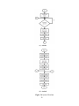
1
Implementation of a Dog Tracking Device and
Positioning System using GSM Technology with
Android Map Application
By
Ma. Teresa O. Arroyo
Eva Rachel A. Retuya
Mimi Jossa M. Rollan
A Thesis Submitted to the School of Electrical, Electronics and Computer
Engineering in Partial Fulfillment of the Requirements for the Degree
Bachelor of Science in Computer Engineering
Mapúa Institute of Technology
June 2014
ii
ACKNOWLEDGEMENT
The researchers humbly express their gratitude to God Almighty for providing
strength and direction while going through the process of completing this study. This also
extends to the following people for the contributions and assistance they had provided.
First and foremost the researchers‟ academe adviser – Engr. Hortinela and course
instructor – Engr. De Leon, for the advice and knowledge that enabled the researchers to
pursue this topic. The panel members – Engr. Cuesta, Engr. Valiente and Engr. Villamor, for
the recommendations they have given for the benefit of the study.
Last but not the least, their friends and family who amidst the hard work and
difficulties provided unwavering support and laughter through tough times.
iii
TABLE OF CONTENTS
TITLE PAGE
i
APPROVAL SHEET
ii
ACKNOWLEDGEMENT
iii
TABLE OF CONTENTS
iv
LIST OF TABLES
vi
LIST OF FIGURES
vi
ABSTRACT
viii
Chapter 1: INTRODUCTION
1
Chapter 2: REVIEW OF LITERATURE
5
Animal Tracking
5
Pet Lost/Abandoned Statistics
7
Global System for Mobile Communication (GSM)
9
Triangulation and Trilateration
12
Cell-ID Positioning
12
Haversine Formula
13
Chapter 3: Implementation of a Dog Tracking Device and Positioning System using GSM
Technology with Android Map Application
15
Abstract
15
Introduction
15
Methodology
19
Fingerprinting Process
24
Statistical Treatment of Data
24
iv
Results and Discussion
26
Interpretation of Results
28
Chapter 4: CONCLUSION
31
Chapter 5: RECOMMENDATION
32
REFERENCES
33
APPENDICES
35
APPENDIX A: SCHEMATIC DIAGRAM OF THE PROTOTYPE
35
APPENDIX B: DEVICE PROTOTYPE
36
APPENDIX C: ACTUAL DEPLOYMENT OF DEVICE
37
APPENDIX D: OPERATION‟S MANUAL
38
v
LIST OF TABLES
Table 2.1 A national survey of 1,014 households owning dogs in the past five years
7
Table 3.1 Common Interpretation of P-Values
25
Table 3.2 Tests Using a Single Tower
27
Table 3.3 Tests Using Two Towers
27
Table 6.1 Android Map Requirements
38
LIST OF FIGURES
Figure 2.1 GSM Architecture
10
Figure 3.1 Conceptual Framework
19
Figure 3.2 Schematic Diagram
21
Figure 3.3 Data Flow Diagram
21
Figure 3.4 System Flowchart
22
Figure 3.5 Sample Text Message
23
Figure 3.6 t-Test for Difference in Population Means
26
Figure 3.7 Illustration of Scope Tests Using a Single Tower
29
Figure 3.8 Illustration of Scope Tests Using Two Towers
30
Figure 6.1 Device Schematic
35
Figure 6.2 Charger Schematic
35
Figure 6.3 Arduino (top), SIM900D (bottom)
36
vi
Figure 6.4 Device tucked in body strap
37
Figure 6.5: Device ON and OFF State
39
Figure 6.6: Charging the device
39
Figure 6.7: Phonebook entry, ADMIN
40
Figure 6.8: Changing the SIM card
41
Figure 6.9: Android Settings - Security
41
Figure 6.10: Copying apk to directory
42
Figure 6.11: Application Installation
42
Figure 6.12: Launching the application
43
Figure 6.13: Splash Screen (top), UI (bottom)
44
Figure 6.14: Settings Screen
45
vii
ABSTRACT
Dogs as a common pet are known as man‟s best friend and in most cases, an
extended family member. When accidentally left unattended, dogs end up astray when they
wander off from their homes. The goal of this research is to develop a portable tracking
device without utilizing GPS and instead relying only on GSM technology. The device is
capable of approximating the general location of the dog through use of Cell-ID method with
addition of one neighboring cell. The researchers will also develop an application based on
the android platform to be used in querying the location of the device. Findings from the
measurements will help evaluate whether the proposed method is sufficient for location
tracking without relying on GPS.
Keywords: animal tracking, GSM, triangulation, trilateration, Cell-ID positioning
viii
Chapter 1
INTRODUCTION
In the United States alone, the number of pets entering shelters per year was
estimated to be between 5 to 7 million (Weiss, 2012). Given the number, pets are lost
from their homes or end up getting abandoned due to owner neglect. These abandoned
and/or lost pets end up fighting for their survival on the streets and the possibility of
being found by their respective owners decrease as time passes by. Being the most
common pet, dogs are on top of the list of lost pets. Lost dogs usually end up astray,
getting hit by vehicles, getting infected by diseases from other stray animals; or worse,
getting butchered by dog-eaters. Stray dogs also have a high reproduction rate which may
endanger the public since the said animal is classified as a source of rabies - a deadly
disease that can be passed on humans commonly by a bite from an infected animal. As
such, stray animals are being caught by authorities where an average of 200 dogs is
euthanized every week at city pounds in the Philippines. The use of tracking devices
apart from identification tags has been an option in the recent years to prevent
incidentally pet loss. On the other hand, the GPS technology as means of tracking is rife
with imperfections which include power management, implementation cost and satellite
visibility around obstructions. The researchers are looking into the development of a
tracking device without relying on GPS but instead deploy a method incorporating GSM
technology as means of all-in-one device not only for communication but for tracking as
well.
1
Animal tracking is existent for years, with most of the endeavor being applied to
wildlife monitoring. Researches in the area often use one or a combination of RFID,
GPS, and sensor networks to carry out tracking, identification and assessment of activity
of the animal. At most, several researches use RFID technology as it was versatile for
both identification and tracking purposes with a recent study based on passive UHF
RFIDs in accordance to the journal of L. Catarinucci et al. entitled “An Innovative
Animals Tracking System based on Passive UHF RFID Technology”. Another recent
study entitled “Animal Situation Tracking Service Using RFID, GPS and Sensors” by
Kim, D.H. et al., involves a more complex approach which is to implement wireless
sensor networks for monitoring state and activity complete with integration of GPS for
tracking and RFID for identification purposes.
There are a lot of studies regarding RFID and GPS; it varies from article to
article where some are applied to car navigation systems, location-based/dependent
applications, and other numerous uses among them which wildlife tracking benefits the
same. On the other hand, wireless sensor networks are often applied for monitoring
environment conditions. Previous researches show domesticated animals i.e. farm-bred
and pets have little or no emphasis with regards to animal tracking. Thus, researchers opt
to focus on this domestic setting, specifically companion pets. The researchers also intend
to examine whether the GSM technology is a viable replacement for GPS given the
accuracy measurements. The deployment of GSM technology as opposed to GPS for
tracking purposes will absolutely mitigate energy consumption and at the same time bring
down costs as it is widely available requiring no special hardware and eventually will
lessen lost pet cases.
2
To address the problem with regards to lost pets specifically dogs that is the
common companion pet, the researchers intend to track the location of the dog using only
the widely-available GSM technology. To realize such concept, the researchers will build
a device to be attached to the dog and that it will not rely on GPS or any other method of
location approximation. The device must be interfaced in such a way for it to receive
request location, scan necessary data to aid location approximation and send that data to a
mobile application that uses the android platform. The researchers will develop the said
android application with the intent to analyze the data gathered by the device attached to
the dog to produce relevant coordinates. Lastly, the overall system must be able to
pinpoint the approximate current location of the dog on a map.
The researchers understand the need to secure safety and well-being of
companion dogs by lessening the chance of them ending up astray and homeless in the
long run as well as avert possible cases of rabies contraction coming from stray dogs. Not
only that, but also the development of the tracking method. The significance lies on the
utilization of GSM technology which is commonly used for communication purposes.
Here, the researchers employed a common technique that base the approximate location
of the device on the location of the tower. From there, further accuracy can be achieved
by utilizing neighboring towers and computing the average coordinate between the
towers. Therefore, the system may be compared to GPS in such a way that it draws
strength by negating the latter‟s imperfections but at the price of sacrificing a little
accuracy. Deployment of GSM as means of location tracking is easy since it is widely
available not to mention cheaper than GPS. Also, it is not as power-hungry and will last
longer on continuous use. There‟s also the fact that GPS does not work in an indoor
3
setting due to obstructions that limit satellite visibility – a known drawback and
limitation. However, the proposed system based on GSM can be used anywhere provided
the device has signal and is powered on.
In this respect, the study will cover a device capable of being queried of its
current location, scan necessary data to be used for location approximation and then
sending the data back for analysis on the android application. The proposed device is
attached to the dog using a customized body strap and is powered using two cellular
mobile batteries. The study however will not cover extensive explanation and detail about
databases pertaining to cellular tower locations. The system will not cover populating of
new data into these databases and is not capable of real-time tracking. It will rest upon
the discretion of the user whether to provide additional cellular tower locations for
accuracy improvements. At the time of writing, the researchers only focused on a small
area to facilitate test results. Loss of signal due to limited coverage areas will be
neglected.
4
Chapter 2
REVIEW OF RELATED LITERATURE
This chapter outlines the primary concepts the study is concerned particularly
the relevant keywords, technology used and the approaches other researchers in the same
field employed to accomplish a similar goal.
Animal Tracking
Several research and applications had existed offering a variety of methods to
carry out animal tracking. According to the journal entitled “An Innovative Animals
Tracking System based on Passive UHF RFID Technology” by Catarinucci et al., a
tracking system was designed for small animals through utilization of passive NF UHF
RFID technology. The working prototype involved 6 built-in-lab NF antennas tested in a
laboratory environment where it has been said that the results are impressive since RFID
is best used in closely-confined spaces. Apart from RFID, other methods employ wireless
sensor networks such as J. Karlsson et al‟s “Tracking and Identification of Animals for a
Digital Zoo” and the “GPS-Less Animal Tracking System” by A. Joshi et al. There are
also several studies that utilize GPS where RFID served other purpose like identification
of animal concerned. According to S.H. Kim et al‟s “Animal Situation Tracking Service
using RFID, GPS and Sensors” and “An advanced Low-Cost, GPS-Based Animal
Tracking System” of P.E. Clark et al, the proposed systems are capable of providing realtime animal information apart from location. RFID and WSNs offer robust nearby
5
tracking capabilities whereas global and/or extensive location tracking is covered by GPS
technology.
Given the size and feature of household pets, it is best to monitor location
whereabouts through GPS. Development of lightweight GPS-tagging device – the work
of M.R. Recio et al. was used to track feral cats which led to the advent of GPS collarbased devices. These devices are functional in tracking wildlife animals as exhibited by
the paper “wildCENSE: GPS Based Animal Tracking System” where the concerned
animal is the swamp deer. (Jain, 2011). On the other hand, domestic animals (such as
cattle) were the subject of a study by Handcock et al in their work, “Monitoring Animal
Behavior and Environmental Interactions using Wireless Sensor Networks, GPS Collars
and Satellite Remote Sensing”. Apart from these, a VHF collar integrated antenna was
also developed and tested on dogs (Yoo, 2011).
A closely related work to this proposal is accomplished by Chakchai So-In et al.
entitled “Mobile Animal Tracking Systems Using Light Sensor for Efficient Power and
Cost Saving Motion Detection”, providing an avenue for open architecture of animal
tracking systems through use of easy-to-access Arduino board coupled with various
carefully-interfaced sensors. The work utilizes the widely-accessible Google MAP API
functionalities where location and sensor data are sent over GSM networks but is
restricted to Android-based phones only. The advantage of this proposal is that it does not
use GPS in locating the animal but instead utilizes the GSM technology to full potential
by also allowing it to be used in location awareness apart from the common
communication use.
6
Pet Lost/Abandoned Statistics
According to the article of E. Weiss et al entitled “Frequency of Lost Dogs and
Cats in the United States and the Methods Used to Locate Them”, 14% of dogs owned in
the US gets lost at least once during a five-year period and the 7% were never reunited
with their owners. The study conducted survey, data collection and statistical analysis to
determine frequency of loss and chances of reuniting with respective owners.
Using the data gathered above to make some estimates of the number of lost pets
in the last 5 years yielded 10,948,000 dogs lost nationally while 766,360 were not
reunited with their owners out of 78.2 million dogs owned across US.
Table 2.1 shows the data relating to the frequency of dogs getting lost, type of ID
worn during the most recent episode and the methods used to find the pet. The survey
reflects participants from all states except Alaska, Delaware, Hawaii and Wyoming.
Table 2.1 A national survey of 1,014 households owning dogs in the past five years
Question
Number of
Percentage of
Dogs
Dogs
Has your pet ever become lost in the past five
years?
Yes
110
14(11-16)
No
705
87(84-89)
Total
815
100
Refused
1
Don‟t Know
0
If yes, how many times was the pet lost?
1 time
2-5 times
6-10 times
More than 10 times
Total
Don‟t Know
52
38
12
5
107
3
7
49 (39-58)
36 (27-45)
11 (6-19)
6 (2-11)
100
Table 2.1 Cont.
Question
Which of the following was your pet wearing the
last time he/she was lost? (more than one could be
worn) n= dog sample size
Wearing a collar (n=109)
Wearing a rabies tag (n=106)
Wearing a license (n=104)
Wearing a personalized ID tag with phone number
(n=109)
Had a microchip (n=103)
No rabies, license or ID tag or microchip (n=101)
Did you find your pet?
Yes
No
Total
Don‟t know
Refused
What was the primary method used to find the pet
(when successful)?
I found my pet by searching my neighborhood
My pet returned on its own
I was contacted because of a tag my pet was
wearing/my pet‟s microchip
Neighbor brought pet home
I found my pet by visiting/contacting animal
control
Other
Total
Refused
What methods were used to attempt to find pet
(unsuccessful)? more than one answer was
possible
Waited for pet to come home
Searched neighborhood
Visited shelter
Hung posters
Ad in paper
Posted online
Called veterinary or other professionals
Other
Refused
8
Number of
Dogs
Percentage of
Dogs
98
74
60
67
90 (83-95)
70 (50-78)
58 (48-67)
61 (52-71)
25
11
24 (16-34)
11 (6-19)
101
8
109
1
0
93 (86-97)
7 (3-14)
100
49
20
15
49 (28-59)
20 (13-29)
15 (9-23)
7
6
7 (3-14)
6 (2-12)
4
101
4 (1-10)
100
6
6
6
4
4
4
3
0
0
75 (35-97)
75 (35-97)
75 (35-97)
50 (16-84)
50 (16-84)
50 (16-84)
38
0
Global System for Mobile Communication (GSM)
Based from the book entitled “MOBILE MESSAGING, Technologies and
Services SMS, EMS and MMS, Second Edition” by G. Le Bodic, GSM is regarded the
most pivotal communication system due to its ability to provide communication between
people anywhere and at any time. It offers robust services such as voice communication,
MMS, EMS, SMS and GPRS with the Short Message Service being the most popular
service. The said service allows subscribers to send and receive short text messages.
According to the journal of Okatan et al, entitled “Micro-Controller Based
Vehicle Tracking System via use of GPS and GSM”, the capacity of SMS convey up to
160B (bytes) of information received or sent from a mobile phone to another. Cellular
devices employ a diverse method in sending electronic messages. Basically, the
electronic message in PDU format is converted into text format and afterwards, the
originator adds parameters to the modified string then is processed by Short Message
Service Centers referred to SMSC.
Based from the dissertation of Mattsson O. entitled “Positioning of a Cellular
Phone using the SIM”, GSM architecture is composed of various distinct components,
divergent to three main sections. Firstly, the Mobile Station consisting of mobile
equipment and the Subscriber Identity Module which in other words is the phone
possessed by the person capable of placing and receiving calls. This is followed by the
Base Station System further comprised of the Base Transceiver and Controller
responsible for connecting the MS to the network and entrusted of transmitting and
receiving. Lastly, the Switching System that manages the interaction between subscribers
and incorporates structured data crucial for subscriber data and mobility management.
9
Figure 2.1 GSM Architecture
Source: Mattsson, 2001 (Positioning of a Cellular Phone using the SIM)
GSM technology is primarily utilized in communication. One application of this
is the “Automatic Ambulance Rescue System” from researchers Athavan, et al. In this
work, nodes made up of traffic junctions are deployed with its own GSM module and
microcontroller embedded. The GPS system determines the location of the vehicle
situated on an accident spot (latitude and the longitude) and sends the information to the
GSM module. This module in turn coordinates to the main server by passing retrieved
data and whose GSM number is already known as an emergency number.
Apart from communication, location awareness both indoor and outdoor can be
carried through GSM. The journal entitled “Are GSM Phones the Solution for
Localization?” written by A. Varshavsky et al argued that localization based on GSM
technology is sufficient enough in coverage and fidelity for a wide extent of applications
in an outdoor, indoor and place-detection setting. The study presented results showing
GSM is rather effective in achieving 2 to 5 meters of median error in room-level tracking
within a building and 70 up to 200 meters of the same error outside.
Also, Mattsson O. (2001) who wrote “Positioning of a Cellular Phone using the
SIM”, obtaining the position through GSM technology can be carried out using different
methods. These include the Cell of Origin referred to as Cell-ID method, several timing
10
techniques, Angle of Arrival and Received Signal Strength. Cell of Origin is plain and
inexpensive procedure to utilize due to non-requirement of any alteration in the handset
or network. The method ascertains the cell identification of the tower the MS is
connected from which has a fix position and that location approximation is determined by
the position of the said tower. Timing Advance on the other hand is used to provide a
more accurate position fix for the cell-ID method where it functions in synchronizing
signals between the mobile phone and the cell tower it connects from. Together with
COO, it can narrow down the radius around the BTS to an approximate 550m wide arc.
Moreover, Mattsson O. (2001) stated on his dissertation “Positioning of a
Cellular Phone using the SIM”, TOA method of approximation comes from quantifying
signals transmitted by the mobile phone to three or more cellular tower where the
received signal is handed towards a Location Measurement Unit or LMU which in turn
determines time spent from which the signal moves between the phone and the tower.
Measurements are then used to calculate a circle around the BTS and the intersection of
the circles coming from at least 3 BTS determines the approximate location of the MS.
On another hand, TDOA is a variation of TOA where it is used when the signal‟s time
sent is indeterminate.
According to “Location Technologies for GSM” by Brida, E-OTD works in a
similar fashion as TDOA but in the other direction; it is based on the MS measuring the
arrival time difference between the bursts of nearby BTSs in GSM. This method requires
modifications to the mobile station and that at least three BTS units are required to
calculate an intersection.
11
The AOA method requires that BTSs to be equipped with antennas in order to
provide measurement of angles of arrival for signals transmitted by the MS. Assuming
such measurements are available, the intersection of the lines defined by angles of arrival
is the supposed location of the MS. It is outlined in the paper “Overview of Location
Techniques” that Received Signal Strength requires a proper propagation model i.e. Hata
model to convert RSS data into distances from the respective neighboring BSs. Standard
trilateration techniques determine the position of MS.
Triangulation and Trilateration
Using the triangulation principle, S. Chao et al (2010) proposed a new method
of frequency planning for new cells under GSM network. The information carried out
through this new cell planning can be utilized in performing localization due to
placement overhead of the concerned cells. (Chao, 2010).
Triangulation and/or trilateration require at least three cells in principle. A study
conducted by Q.R. Mahfuz et al for vehicle tracking utilized cell information such as
timing advance gathered from three different cells to calculate the vehicle‟s exact
location. The reported accuracy of the study lies within a circle of 200-meter radius.
(Parvez, 2010).
Cell-ID Positioning
The main highlight of Cell-ID positioning is its capability to localize any GSM
mobile subscriber where location accuracy depends on size and density of network cells
12
and that no software or hardware changes are needed by both the network and the mobile
phone.
I.Gregor et al (2008) produced a prototype named SS7Tracker based on GSM
Cell-ID Positioning. (Novak, 2008). The said prototype is an active, non-intrusive
networked-based location tracking where periodic querying of the network about the
location of concerned devices is performed unlike passive tracking methods where
location information is only generated when there is direct contact between a mobile
phone and the GSM network.
The Cell-ID method of location approximation is entirely based on the location
of the serving BTS and its surrounding radius meaning, accuracy isn‟t as par with GPS.
However, several studies tried to improve this method by introducing the Enhanced CellID method. M.M. Petrovic et al in particular proposed a better positioning technique in
the journal entitled “Enhanced Cell-ID+ TA GSM Positioning Technique” where the said
technique utilized timing advance variables from all apparent BTSs in the area combined
with the empirically modeled behavior of timing advance and an algorithm for evaluating
the position of MS. The location error with the proposed system is found at 135m of 67%
accuracy and 245m of 95% accuracy compared to Cell-ID‟s 283m, 67% accuracy.
Haversine Formula
According to the amateur astronomy magazine Sky & Telescope under the
article “Virtues of the Haversine” published by Roger Sinnott, haversine was used in
navigation. The haversine formula is a very accurate way of computing distances
13
between two points on the surface of a sphere using the latitude and longitude of the two
points. The haversine formula is a re-formulation of the spherical law of cosines, but the
formulation in terms of haversines is more useful for small angles and distances. The
haversine formula could yield accurate results without requiring the computationally
expensive operations of squares and square roots. Moreover, the said magazine was
singing the praises of the haversine formula, which is not only useful for terrestrial
navigation but also for celestial calculations.
Based from the journal “Effective Technique for Allocating Servers to Support
Cloud using GPS and GIS” by Ayad Ghany Ismaeel, the algorithm of haversine formula
was used to compute the nearest/distance between the source server and the idle server to
support cloud in a more effective cost.
Moreover, the haversine formula was also used to calculate the minimum
ambulance travelling distance between longitude and latitude in kilometres and miles in
the journal of Noraimi Azlin Mohd Nordin,et al entitled “Finding Shortest Path of the
Ambulance Routing: Interface of A* Algorithm using C# Programming.”
14
Chapter 3
Implementation of a Dog Tracking Device and Positioning System using
GSM Technology with Android Map Application
Abstract
Dogs as a common pet are known as man‟s best friend and in most cases, an
extended family member. When accidentally left unattended, dogs end up astray when
they wander off from their homes. The goal of this research is to develop a portable
tracking device without utilizing GPS and instead relying only on GSM technology. The
device is capable of approximating the general location of the dog through use of Cell-ID
method with addition of one neighboring cell. The researchers will also develop an
application based on the android platform to be used in querying the location of the
device. Findings from the measurements will help evaluate whether the proposed method
is sufficient for location tracking without relying on GPS.
Keywords: animal tracking, GSM, triangulation, trilateration, Cell-ID positioning
Introduction
In the United States alone, the number of pets entering shelters per year was
estimated to be between 5 to 7 million (Weiss, 2012). Given the number, pets are lost
from their homes or end up getting abandoned due to owner neglect. These abandoned
and/or lost pets end up fighting for their survival on the streets and the possibility of
being found by their respective owners decrease as time passes by. Being the most
common pet, dogs are on top of the list of lost pets. Lost dogs usually end up astray,
getting hit by vehicles, getting infected by diseases from other stray animals; or worse,
getting butchered by dog-eaters. Stray dogs also have a high reproduction rate which may
endanger the public since the said animal is classified as a source of rabies - a deadly
15
disease that can be passed onto humans commonly by a bite from an infected animal. As
such, stray animals are being caught by authorities where an average of 200 dogs is
euthanized every week at city pounds in the Philippines. The use of tracking devices
apart from identification tags has been an option in the recent years to prevent
incidentally pet loss. On the other hand, the GPS technology as means of tracking is rife
with imperfections which include power management, implementation cost and satellite
visibility around obstructions. The researchers are looking into the development of a
tracking device without relying on GPS but instead deploy a method incorporating GSM
technology as means of all-in-one device not only for communication but for tracking as
well.
Animal tracking is existent for years, with most of the endeavor are being
applied to wildlife monitoring. Researches in the area often use one or a combination of
RFID, GPS, and sensor networks to carry out tracking, identification and assessment of
activity of the animal. At most, several researches use RFID technology as it was
versatile for both identification and tracking purposes with a recent study based on
passive UHF RFIDs such as “An Innovative Animals Tracking System based on Passive
UHF RFID Technology”. Another recent study entitled “Animal Situation Tracking
Service Using RFID, GPS and Sensors” involves a more complex approach which is to
implement wireless sensor networks for monitoring state and activity complete with
integration of GPS for tracking and RFID for identification purposes.
There are a lot of studies regarding RFID and GPS; it varies from article to
article where some are applied to car navigation systems, location-based/dependent
applications, and other numerous uses among them which wildlife tracking benefits the
16
same. On the other hand, wireless sensor networks are often applied for monitoring
environment conditions. Previous researches show domesticated animals i.e. farm-bred
and pets have little or no emphasis with regards to animal tracking. Thus, researchers opt
to focus on this domestic setting, specifically companion pets. The researchers also intend
to examine whether the GSM technology is a viable replacement for GPS given the
accuracy measurements. The deployment of GSM technology as opposed to GPS for
tracking purposes will absolutely mitigate energy consumption and at the same time bring
down costs as it is widely available requiring no special hardware and eventually will
lessen lost pet cases.
To address the problem with regards to lost pets specifically dogs that is the
common companion pet, the researchers intend to track the location of the dog using only
the widely-available GSM technology. To realize such concept, the researchers will build
a device to be attached to the dog and that it will not rely on GPS or any other method of
location approximation. The device must be interfaced in such a way for it to receive
request location, scan necessary data to aid location approximation and send that data to a
mobile application that uses the android platform. The researchers will develop the said
android application with the intent to analyze the data gathered by the device attached to
the dog to produce relevant coordinates. Lastly, the overall system must be able to
pinpoint the approximate current location of the dog on a map.
The researchers understand the need to secure safety and well-being of
companion dogs by lessening the chance of them ending up astray and homeless in the
long run as well as avert possible cases of rabies contraction coming from stray dogs. Not
only that, but also the development of the tracking method. The significance lies on the
17
utilization of GSM technology which is commonly used for communication purposes.
Here, the researchers employed a common technique that base the approximate location
of the device on the location of the tower. From there, further accuracy can be achieved
by utilizing neighboring towers and computing the average coordinate between the
towers. Therefore, the system may be compared to GPS in such a way that it draws
strength by negating the latter‟s imperfections but at the price of sacrificing a little
accuracy. Deployment of GSM as means of location tracking is easy since it is widely
available not to mention cheaper than GPS. Also, it is not as power-hungry and will last
longer on continuous use. There‟s also the fact that GPS does not work in an indoor
setting due to obstructions that limit satellite visibility – a known drawback and
limitation. However, the proposed system based on GSM can be used anywhere provided
the device has signal and is powered on.
In this respect, the study will cover a device capable of being queried of its
current location, scan necessary data to be used for location approximation and then
sending the data back for analysis on the android application. The proposed device is
attached to the dog using a customized body strap and is powered using two cellular
mobile batteries. The study however will not cover extensive explanation and detail about
databases pertaining to cellular tower locations. The system will not cover populating of
new data into these databases and is not capable of real-time tracking. It will rest upon
the discretion of the user whether to provide additional cellular tower locations for
accuracy improvements. At the time of writing, the researchers only focused on a small
area to facilitate test results. Loss of signal due to limited coverage areas will be
neglected.
18
Methodology
Figure 3.1 Conceptual Framework
The Conceptual Framework of the study consists of two main parts. The first
part is the gathering of information about the surrounding towers gathered by the AT
command Engineering mode (AT+CENG) which displays parameters needed to identify
cell towers such as Mobile Country Code, Mobile Network Code, Location Area Code,
Cell ID, Absolute Radio Frequency Channel Number and Base Station Identity Code
from the SIM900D GSM/GPRS module and ATMEGA328 microcontroller. These
19
parameters can be seen in the AT Commands Manual. The second part is the interpreting
of the gathered information in an Android application via retrieval of related information
from a database i.e. “opencellid” and in turn translates the data into GPS coordinates
which Google Maps use to show the location in a map.
The first part consists of interfacing the ATMEGA328 microcontroller and the
SIM900D GSM module. The GSM module was programmed using AT Commands while
the microcontroller was programmed using Arduino language which is a C-like language.
Both were programmed in Arduino IDE with the use of SoftwareSerial library and
MsTimer2 library for the GSM module to be able to communicate with the
microcontroller. The second part consists of the Android application which interprets data
from the received SMS into longitude and latitude or GPS coordinates. The Android
application
was
programmed
in Basic4Android
language.
(a)
20
which uses JAVA programming
(b)
Figure 3.2 Schematic Diagram
In figure 3.2 (a), the ATMEGA328 microcontroller is connected to SIM900D
GSM module, 16MHz crystal oscillator and to two serially connected 3.4 volt Li-Ion
batteries which serve as the power supply of the device when in use. The microcontroller
is also connected to UART for programming purposes. Figure 3.2 (b) is the schematic
diagram of the provided charger for the device which is composed of a transformer,
bridge diode, capacitor and a voltage regulator that has an output of 9 volts. It can also be
used as an external source of power if applicable.
Figure 3.3 Data Flow Diagram
21
(a) Arduino
(b) Android
Figure 3.4 System Flowchart
22
The device being tracked (ATMEGA328 microcontroller and GSM module) is
located at the back of the dog and the device that tracks (where the Android application is
installed) is the client-side device. Both the devices should be active or turned on and
must have prepaid load in order to communicate. The client-side device should also be
connected to the internet for accessing the database and loading the map.
Using AT Commands, the GSM module was able to send and receive messages.
All received messages are checked whether or not they comply with the correct format.
The format of the message should be “TRACK” with no other characters and characters
should be in upper case, otherwise it will be deleted and no further actions will be done.
If the message was validated, the GSM module will gather information about the cell
tower it is currently connected to as well as some information regarding the neighboring
towers. This information will then be sent to the phonebook entry named ADMIN which
is determined by the user before placing the SIM card into the device. The cell tower
information included in the SMS are MCC, MNC, Cell ID, RSS, LAC, ARFCN, and
BSIC, respectively, of the servicing tower denoted by “0” at the beginning of the message
and the ARFCN, LAC and BSIC of the neighboring tower denoted by “:1”, if a
neighboring tower is available. The GSM module can only connect to 2G towers, thus 3G
and 4G towers cannot be used in this study.
0_515_02_561a_-72_4f05_”0844_62:1_4f03_”0033_09
Figure 3.5 Sample Text Message
Upon receiving the text message from the device, the Android application will
then access the database for the cell towers‟ GPS coordinates. The number of GPS
coordinates generated may vary from the number of tower information received
23
depending if the towers were already added to the database. A single location will then be
derived from the gathered coordinates which will be displayed in a map.
A mobile phone is only able to connect to one cell tower at a time. All the cell
tower information mentioned above is available for only the said cell tower. For the
neighboring towers, only limited information can be gathered.
Fingerprinting Process
Fingerprinting is the process of collection of data for the purpose of identification.
This process is used by the researchers in population of cell tower information such as
cell ID, LAC, ARFCN and BSIC, and their respective GPS coordinates in the database.
Open-source and crowd-sourced database such as “opencellid.org” do not collect cell
tower information aside from cell ID. This limits the researchers to resort in using only
one tower. However, the database used in this research utilizes other cell tower
information in recognizing the identity of neighboring towers.
Since the researchers used a new database, fingerprinting is a must. This process
is done thoroughly in a specific area to assure the accuracy of the location of the towers.
Statistical Treatment of Data
H0 :
2
1
Null Hypothesis
(3.1)
24
H1 :
2> 1
Alternative Hypothesis
(3.2)
The null hypothesis states that the calculated distance or relative error of the
device from the calculated location to the actual location is more accurate when utilizing
two towers in generating the location of the device than that when using only a single
tower. The alternative hypothesis on the other hand indicates that the results generated
from a single tower are more accurate than those from two towers or both methods would
yield the same accuracy.
Table 3.1 Common Interpretation of P-Values
P-value
Interpretation
Very strong evidence against the
hypothesis
moderate evidence against the hypothesis
suggestive evidence against the hypothesis
little or no real evidence against the
hypothesis
P< 0.01
0.01
0.05
P < 0.05
P < 0.10
0.10
P
Using the critical value that can be found at Fig. 3.6, we note that the observed
test statistic value is in the rejection region since 2.7699 < 2.845. We thus accept the null
hypothesis (H0 :
2> 1)
2
1)
with a p-value of 0.99, and reject alternative hypothesis (H1 :
with a p-value of around 0.01 which shows very strong evidence against the said
hypothesis. Therefore, we conclude that the null hypothesis with a p-value of 0.99 is an
accepted hypothesis at the 5% level of significance. This is a very small p-value
(compared to 5%), and thus we have a statistically significant result, i.e., very strong
evidence accepting the null hypothesis.
25
We thus accept the null hypothesis at the 5% level. It appears that the difference
in distance between using single tower and two towers, using two towers yields more
accurate results.
Figure 3.6 t-Test for Difference in Population Means
Results and Discussion
The testing of the system was conducted at Intramuros, Manila. For testing
purposes, the researchers have fingerprinted the area prior to the actual testing in order to
ensure that the towers used are added to the database. Calculated GPS location is based
from the system while Actual GPS location is based from the GPS location derived from
Google Maps with the use of internet. The tests include locating the device using single
tower and using two towers with the use of neighboring tower‟s GPS location.
26
Trial
1
2
3
4
5
6
7
8
9
10
11
12
13
14
15
16
17
18
19
20
Table 3.2 Tests Using a Single Tower
Calculated GPS location
Actual location
Latitude
Longitude
Latitude
Longitude
14.59317
120.978695
14.588194
120.978695
14.589525
120.978789
14.586532
120.977622
14.588425
120.976161
14.587591
120.976657
14.588425
120.976161
14.588547
120.975884
14.589338
120.976448
14.58946
120.975069
14.591835
120.973492
14.590457
120.974103
14.59169
120.973039
14.591703
120.972987
14.588425
120.976161
14.585826
120.97612
14.589338
120.976448
14.587467
120.977987
14.588635
120.977861
14.588817
120.977622
14.588635
120.977861
14.589626
120.976828
14.590553
120.97714
14.592637
120.974103
14.589616
120.975614
14.590062
120.975498
14.589616
120.975614
14.589211
120.976313
14.589076
120.978671
14.58838
120.977
14.588425
120.976161
14.589377
120.97818
14.590553
120.97714
14.589377
120.97818
14.589338
120.976448
14.59108
120.976571
14.592469
120.975646
14.59272
120.976657
14.592469
120.975646
14.592658
120.975176
Average
Relative
Error (km)
0.5533
0.3557
0.1070
0.0327
0.1490
0.1667
0.0058
0.2890
0.2659
0.0327
0.1565
0.4006
0.0511
0.0877
0.1958
0.2417
0.1721
0.1942
0.1123
0.0548
0.1812
Table 3.3 Tests Using Two Towers
Trial
1
2
3
4
5
6
7
8
9
10
11
12
13
14
15
Calculated GPS location
Latitude
Longitude
14.58886
14.58674
14.58811
14.58894
14.58954
14.59146
14.59177
14.58723
14.58795
14.58862
14.58948
14.59255
14.5897
14.58892
14.58895
Actual location
Latitude
Longitude
120.9787
120.9777
120.9773
120.9762
120.9753
120.9749
120.9732
120.975
120.9771
120.9769
120.9766
120.9749
120.976
120.9771
120.9779
14.588194
14.586532
14.587591
14.588547
14.58946
14.590457
14.591703
14.585826
14.587467
14.588817
14.589626
14.592637
14.590062
14.589211
14.58838
27
120.978695
120.977622
120.976657
120.975884
120.975069
120.974103
120.972987
120.97612
120.977987
120.977622
120.976828
120.974103
120.975498
120.976313
120.977
Relative
Error (km)
0.0742
0.0229
0.0870
0.0534
0.0306
0.1393
0.0281
0.1981
0.1118
0.0816
0.0260
0.0835
0.0651
0.0892
0.1154
Table 3.3 Cont.
Trial
16
17
18
19
20
Calculated GPS location
Latitude
Longitude
14.58923
14.58945
14.59213
14.59228
14.59161
Actual location
Latitude
Longitude
120.9784
120.9785
120.9776
120.9751
120.9762
14.589377
14.589377
14.59108
14.59272
14.592658
Average
120.97818
120.97818
120.976571
120.976657
120.975176
Relative
Error (km)
0.0313
0.0338
0.1630
0.1773
0.1577
0.0885
Tables 3.2 and 3.3 show the calculated GPS locations based from the tower or
towers that the device was connected to, the actual GPS location of the device based from
Google maps, and the relative error or the distance of the two GPS locations in
kilometers. In the event that the device has connected to only one tower, the calculated
GPS location will be equal to the GPS location of the tower based on the database as
shown in Table 3.2. On the other hand, when two towers are detected by the device, the
calculated GPS location will be equal to the average or midpoint of the GPS locations of
the two towers as seen on Table 3.3.
Interpretation of Results
In the event that only one tower information is gathered, the calculated GPS
location will be equal to the GPS location of the tower away from the device. Whereas, if
two tower information are gathered, the calculated GPS location will be equal to the two
towers‟ GPS location divided by two.
The results are dependent on the sufficiency of available towers on the database.
The results may also vary widely if the database is updated and approximate tower
locations were adjusted.
28
For a single cell tower, the scope of the calculated location is illustrated in figure
3.5. The results may be closer to where the device is but a lot less accurate because the
area covered by a single tower is located within a distance band of a cell tower circle.
For two cell towers, the scope of the calculated location is illustrated in figure 3.6. The
results is more accurate than of that of the single tower though at times farther from the
device because the area covered by two towers is located within a distance band of where
two cell tower circles overlaps.
Table 3.1 shows that the GPS locations generated from a single tower range from
0.0058km to 0.5533km and have a mean value of 0.1812km; while Table 3.2 shows that
the GPS locations generated from two towers range from 0.0229km to 0.1981km and
have a mean value of 0.0885km. Thus, the number of cell towers located has an effect in
the degree of accuracy of the device. Based from the testing done it proves that for the
results from using two towers is almost twice more accurate than using single tower.
Figure 3.7 Illustration of Scope Tests Using a Single Tower
Source: Khalid, A. M. (2007) Location Aware System Using Mobile Station in
GSM Network
29
Figure 3.8 Illustration of Scope Tests Using Two Towers
Source: Khalid, A. M. (2007) Location Aware System Using Mobile Station in
GSM Network
30
Chapter 4
CONCLUSION
A successful opportunity was developed for the GSM technology in terms of
tracking animals (dog) which is mostly known to be used in communication. Based from
the gathered data, the results are proven to be sufficient in tracking the said animal. Thus
the researchers conclude that position tracking of the device with the use of GSM
technology was a success. The device was able to receive request, scan nearby towers‟
information and send it to a client-side application. The gathered data was successfully
interpreted by the application producing coordinates to locate the current position of the
device.
Compared to other tracking devices, the design was proven to have economic
and environmental benefits in terms of hardware components and energy consumption,
respectively. It has also been established that the device has considerate advantage when
it comes to tracking sustainability and manufacturability.
31
Chapter 5
RECOMMENDATION
Since the density of cell towers available in the area defines the accuracy of the
location, the researchers recommends having at least three or more base stations to utilize
the device location and provide more accurate results.
Also, the designer of the system recommends using the device in urban areas
rather than rural areas because the accuracy decreases as there are less cell towers in the
area.
As for the future researchers, a good accuracy algorithm may also be developed
in place of what the current researchers utilized at the time of this writing in hopes of
achieving a better result.
32
REFERENCES
Ahmed, K.Z., et al, (2010). A Theoretical Model of GSM Network Based Vehicle
Tracking System. 6th International Conference on Electrical and Computer Engineering
(ICECE), pp. 594-597.
Akpolat, C., et al, (2003). Micro-Controller based Vehicle Tracing System via use of
GPS and GSM. Recent Advances in Space Technologies, pp. 605-609.
Anonymous.“Overview of Location Techniques” Diss. University of Cyprus. Print.
Athavan, K., et al, (2012).Automatic Ambulance Rescue System. Advanced Computing
& Communication Technologies (ACCT), pp. 190-195.
Bagree, R., et al, (2008). wildCENSE: GPS based Animal Tracking System. Intelligent
Sensors, Sensor Networks and Information Processing, 2008. ISSNIP 2008, pp. 617-622.
Bishop-Hurley, G.J., et al, (2009). Monitoring Animal Behaviour and Environmental
Interactions Using Wireless Sensor Networks, GPS Collars and Satellite Remote Sensing.
Sensors, volume 9(5), pp. 3586-3603.
Borenovic, M.N., et al, (2005). Enhanced Cell-ID + TA GSM Positioning Technique.
Computer as a Tool, EUROCON, volume 2, pp. 1176-1179.
Brida, P., Location Technologies for GSM. Diss. University of Zilina. Print.
Catarinucci, L., et al, (2010). An Innovative Animals Tracking System based on Passive
UHF RFID Technology. International Symposium on RFID Technologies & Internet of
Things (SoftCOM), pp. 1-7.
Chao, S., et al, (2010). A new method of frequency planning for new cells in GSM.
Environmental Science and Information Application Technology (ESIAT), volume 3, pp.
420-423.
Chen, M.Y., et al, (2005). Are GSM phones THE solution for localization? Mobile
Computing Systems and Applications, 2006. WMCSA '06, pp. 34-42.
Clark, P.E., et al, (2006). An Advanced, Low-Cost, GPS-Based Animal Tracking System.
Rangeland Ecology & Management 59(3), pp. 334-340.
Denys, P., et al, (2011). Lightweight GPS-Tags, One Giant Leap for Wildlife Tracking?
An Assessment Approach. PLoS ONE, volume 6 (12), pp. 1-12.
33
Dufková, K., et al, (2008). Active GSM cell-id tracking: "Where Did You
Disappear?”.MELT '08 Proceedings of the first ACM international workshop on Mobile
entity localization and tracking in GPS-less environments, pp. 7-12.
Ismaeel, A.G. (2013). Effective technique for allocating servers to support cloud using
GPS and GIS. Science and Information Conference (SAI), pp.934-939.
Joshi, A., et al, (2008). GPS-Less Animal Tracking System. Wireless Communication
and Sensor Networks, 2008. WCSN 2008. Fourth International Conference, pp. 120-125.
Karlsson J., H. Li and K. Ren (2010). Tracking and Identification of Animals for a
Digital Zoo. 2010 IEEE/ACM International Conference on Green Computing and
Communications & 2010 IEEE/ACM International Conference on Cyber, Physical and
Social Computing, pp. 510-515
Kim, D.H., S.H. Kim, and H.D. Park (2010). Animal Situation Tracking Service Using
RFID, GPS, and Sensors. Second International Conference on Computer and Network
Technology, pp. 153-156
Le Bodic, G., (2005). Mobile Messaging, Technologies and Services: SMS, EMS and
MMS, 2nd Edition, John Wiley & Sons Ltd, England.
Maasar, M.A., et al, (2012). Finding Shortest Path of the Ambulance Routing: Interface
of A* Algorithm using C# Programming. 2012 IEEE Symposium on Humanities, Science
and Engineering Research (SHUSER), pp. 1569-1573.
Mattsson, O., (2001). Positioning of a Cellular Phone using the SIM. Diss. Royal
Institute of Technology. Print.
Melde, K.L., and S. Yoo, (2012). VHF Collar Integrated Antenna for Ground Link of
GPS Based Location System. Antennas and Propagation, IEEE Transactions, volume
61(1), pp. 26-32.
Sinnott, R. W., (1984). Virtues of the Haversine. Sky and Telescope, vol.68 (2), p.159.
So-In, C., et al, (2012). Mobile Animal Tracking Systems Using Light Sensor for
Efficient Power and Cost Saving Motion Detection. Communication Systems, Networks
& Digital Signal Processing (CSNDSP), 2012 8th International Symposium, pp. 1-6.
Weiss, E., et al, (2012). Frequency of Lost Dogs and Cats in the United States and the
Methods Used to Locate Them. Animals, pp. 301-315.
34
APPENDICES
APPENDIX A
SCHEMATIC DIAGRAM OF THE PROTOTYPE
Figure 0.1 Device Schematic
Figure 0.2 Charger Schematic
35
APPENDIX B
DEVICE PROTOTYPE
Figure 0.3 Arduino (top), SIM900D (bottom)
36
APPENDIX C
ACTUAL DEPLOYMENT OF DEVICE
(a)
(b)
Figure 0.4 Device tucked in body strap
37
APPENDIX D
OPERATION’S MANUAL
System Requirement
Table 0.1 Android Map Requirements
Item
Requirement
Android Version
Minimum: 2.3 (Gingerbread)
Supported up to 4.3 (Jelly Bean)
Valid Internet Access
2G to latest or Wi-Fi connection
User’s Manual
1
1.1
1.2
1.3
Device
Operating the device
Charging the device
Changing SIM card
2
2.1
2.2
2.2.1
2.2.2
2.2.2
Android Application
Installing the application
Operating the application
Tracking Screen
Changing the settings
Tracking the device
1
DEVICE
1.1 Operating the device
Place the device in a secure location. Make sure it will not fall off or get wet. When ready
to use, flick the toggle switch. It will take a minute for the GSM module to initialize.
LEDs indicate whether the device is turned on or off. After use, flick the toggle switch to
turn the device off. Refer to Figure 6-4 for toggle button‟s ON and OFF positions.
38
Figure 0.5: Device ON and OFF State
1.2 Charging the device
When the device is turned on for a long time or when the power of the device is running
low, it is advised that the user should turn off the device before plugging in the charger
supplied with the device.
Connect the device to the supplied charger making sure the correct polarity is observed as
shown in Figure 6-5.
Figure 0.6: Charging the device
1.3 Changing the SIM card
If the user wants to change the SIM card of the device, he/she is advised to follow these
steps first:
39
1. Insert the new SIM card to another device.
2. Create a contact or phonebook entry in SIM memory named “ADMIN” without
the quotations and all capital letters. Use the number of the phone where the
supplied Android Application is installed. (Ex. Name – ADMIN Number 09171234567). See Figure 6-6 for reference.
Figure 0.7: Phonebook entry, ADMIN
3. After saving the phonebook entry, remove the new SIM card from the other
device.
Make sure that the device is turned off. Unscrew the screws that secure the GSM module
inside the device. If there is a SIM card in the SIM card slot, remove it and replace with
the new SIM card. Once placed, put back the cover and secure the device with screws.
Refer to Figure 6-7 for the detailed steps.
40
Figure 0.8: Changing the SIM card
2
ANDROID APPLICATION
2.1 Installing the application
1. Navigate to the phone settings and under Security, tick a check in the box under
Device Administration that says Unknown Sources.
Figure 0.9: Android Settings - Security
The application is not yet publicly released to the official app market hence the
user should Allow installation of apps from sources other than the Play Store
as shown in Figure 6-1.
41
2. Copy the supplied android application, named arfcnLocator.apk, into a preferred
directory of choice in the android phone. Check Figure 6-2 below for an example.
Figure 0.10: Copying apk to directory
3. Choose or tap the file and follow normal installation procedures as illustrated in
Figure 6-3.
Figure 0.11: Application Installation
42
The device on the other hand should be placed in a stable surface such as the
car‟s dashboard. Items that may disrupt reception should be kept away from
the device.
2.2 Operating the application
When the user wants to use the application, choose or tap the logo of the installed
application named Locate My Dog as shown by Figure 6-8.
Figure 0.12: Launching the application
2.2.1
Tracking screen
The application will open showing a splash screen first and then an interface showing
several buttons namely Track, Settings, Details, Reload, as well as Forward and
Backward. Refer to Figure 6-9 for visualization.
a) Track – sends an SMS message to the device attached on the dog, querying it for
location determination. Once an appropriate reply is received, it grabs data
(coordinates) on the server and loads the map pinpointing the coordinates
obtained from the server.
43
b) Settings – used to specify the number of the SIM card which is attached to the
device as well as the IP address of the server needed to extract data from.
c) Details – shows text message details such as the serving and neighboring tower
information. An address is also shown when applicable.
d) Reload, Forward and Backward – used to reload, move forward or backward a
page on the map. Acts the same purpose found on common web browsers.
Figure 0.13: Splash Screen (top), UI (bottom)
2.2.2
Changing the settings
Once the Settings button is pressed, a new window will pop up.
44
Figure 0.14: Settings Screen
From Figure 6-10, enter the SIM card number in the text box (example: 09191234567)
prompted under Mobile Number. A valid mobile number must not exceed or be less than
11-digits. Tracking will not proceed until this rule is observed; this is done to ensure each
text message sent is valid and will reach the intended destination. If the user typed a
wrong number or wishes to change what has been applied, he/she can re-enter the
number.
Specify the IP address of the server where the data concerning coordinates will be
fetched. To know the IP address, go to the host machine and type „ipconfig’ in command
prompt and find the „IPv4 Address‟. This is the required IP address. Again, tracking will
not commence unless a valid IP address is entered.
When the user is satisfied with the settings, he/she can press the hardware back button to
go back to the tracking screen.
45
2.2.3
Tracking the device
To track the device, the user must apply the appropriate SIM card number in the settings
first. Make sure that the device placed on the dog is turned ON and both the device and
the android mobile phone have sufficient load balance. Just press Track and observe the
onscreen prompts and wait until the map is loaded. See Figure 6-9 for reference of button
positions.
Troubleshooting Guides and Procedures
1. Device does not turn ON or stopped working.
Make sure the battery is fully charged and the switch is flicked to ON state. The LEDs
will indicate if there is power.
2. No message received from the android application.
Try resetting the device, to do this flick the switch to OFF state then turn it back ON.
Let the device settle in a minute before querying it again via the android application.
Make sure there is SIM inserted on the device and both device and mobile phone should
have prepaid balance beforehand. If the device is unavailable, try pressing the track
button again per 5-minute intervals until a reply is received.
3. Map does not load.
This is a common problem on a slow internet connection. Just wait until it properly
loads the map.
46
4. App crashes upon trying to load the map.
Most likely the area visited has no database information yet. This is normal and the
only solution is to upload measures of cell data from the concerned location.
47