1
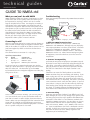
technical guides
www.cactusnav.com
GUIDE TO NMEA
Wir scheinen, eine Sprachbarriere
zu haben hier. Kann jemand mich
verstehen?
Moshi moshi.
Wakaramasu-ka?
Most marine electronics boast about being “NMEA compatible”, but what does that mean? What does NMEA
compatibility allow you to do? How easy is it to connect equipment together using NMEA?
NMEA stands for National Marine Electronics Association,
which is the US body that attempts to regulate marine electronics manufacturers in that country (the UK equivalent is
the BMEA). When equipment claims to be “NMEA compatible”, what they are actually saying is that they are compliant
with the standard communications protocol as defined by
the NMEA. The protocol has gone through various stages
of evolution since it’s initial concept, but the current version
that virtually all marine equipment is compatible with is
NMEA0183.
What is NMEA0183?
This is a standardised electronic language that enables
equipment made by different manufacturers to have a limited level of interaction and communication. Electronics
manufacturers have their own proprietry protocols (such as
SeaTalk and HSB2 from Raymarine) which would normally
limit interaction to equipment made by the same manufacturer, but NMEA compatibility means that critical information
is translated into standardised NMEA data sentences which
can be understood by any other equipment set up to read
the same sentences. Thus, your Garmin GPS can provide
position data to your Raymarine chart plotter, which in turn
can send course data to your Simrad autopilot.
What does NMEA data consist of?
This is an example of a typical NMEA0183 sentence output
by a chartplotter RMB, A, 0.66, L, 003, 004, 4917.24,N, 12309.57,W, 001.3, 052.5, 000.5, V*0B
RMB
A
0.66,L
003
004
4917.24,N
12309.57,W
001.3
052.5
000.5
V
Sentence name (Recommended Minimum Nav Info)
Data status A = OK, V = warning
Cross-track error (nautical miles), steer Left to correct
Origin waypoint ID
Destination waypoint ID
Destination waypoint latitude 49deg. 17.24min. N
Destination waypoint longitude 123deg. 09.57min. W
Range to destination, nautical miles
True bearing to destination
Velocity towards destination, knots
Arrival alarm A = arrived, V = not arrived
This shows the amount of data that can be contained in an
NMEA0183 sentence. It might look complicated, but you
don’t need to worry - in reality you’re never going to see
the information expressed in this way, all equipment made
today automatically processes the data and displays it on
screen in a usable format.
¡Los saludos!
¿Habla usted Seatalk?
Je ne sais pas de ce
que tout vous parle!
small selection of sentences relevant to what the equipment is doing. So, for example a radar will typically be able
read Lat/Long and Compass data via NMEA because this
data can be used to enhance the performance of the radar.
On the other hand it’s unlikely to be able to read water
depth because this information is ultimately useless to the
radar. A fishfinder or sonar is more likely to be able to
receive NMEA depth data.
The next thing you need to check is that both units understand the same NMEA format. It’s not enough that they’re
both NMEA0183 compatible - it needs to be the same version of NMEA0183. A lot of equipment gives you the
option to select version 1.5, 2.0 or 3.0.
Then you need to check the connections. If you want the
unit to talk to another piece of equipment, you want to look
for a port labelled NMEA OUT. If you want the unit to listen
to data from another piece of equipment, look for the
NMEA IN port.
NMEA In
Data coming into the
unit from an external
source
NMEA Out
Data produced or echoed
by the unit going out to
another unit
Some units may have a special NMEA lead supplied, others
may just be screw terminals and you have to supply your
own cable. Pretty much any standard two-core cable will
work fine. Reading the various user manuals you will then
find that there is little consistency when it comes to references for the NMEA connections - some talk about NMEA
Data and Common, others NMEA + and - or even NMEA A
and B. Whatever they call them you basically have a wire
that supplies data, plus a return wire. Don’t be distracted
by the wire colours of any cable that might come with the
unit - there is no colour standard for NMEA cables and it
will vary depending on the manufacturer and which cable
they are using.
Making it work
If you want to be able to connect two pieces of equipment
together, you first need to establish that they are going to
talk to each other. They may both be NMEA compatible,
but most equipment only transmits or receives a relatively
page 1 of 3
IMPORTANT You need to connect the NMEA OUT terminals of the “talking” unit to the NMEA IN terminals of the
“listening” unit.
Issue 1.0 22/07/2003
technical guides
www.cactusnav.com
GUIDE TO NMEA ctd
What you can/can’t do with NMEA
Troubleshooting
NMEA interfacing allows two pieces of equipment to share
simple data such as boat speed, course and current position expressed as Lat/Long. What it can’t do is transfer
large or complex items of data. For example, connecting a
chart plotter and a radar together may allow the radar to
read course and position data from the chart plotter, or the
chart plotter can plot a position based on a mark placed on
the radar, but the radar wouldn’t be able to download a
chart picture from the plotter via NMEA, and the plotter
couldn’t display a radar image. For large amounts of data
like this you need a high speed data link, such as
Raymarine’s HSB2 system or Furuno’s Navnet.
There are generally five reasons why NMEA interconnection
isn’t working -
With PCs and laptops becoming a more common feature on
boats and with a whole range of navigational software available on the market, it is useful to be able to connect a PC to
your boat equipment, which can be done via the RS232
serial ports.
The standard RS-232 connector is a 9 pin plug Connect To
NMEA Out Data
NMEA In Data
NMEA In/Out Common
NMEA In Data
NMEA In Common
NMEA Out Data
NMEA Out Common
To connect your PC to external equipment you need to
make up a serial cable with a 9 pin plug one end and bare
wires the other end. The bare wires go to the NMEA
In/Out terminals on the navigation equipment and the plug
end goes to the PC RS232 Rx Data
RS232 Tx Data
RS232 Signal Ground
9 Pin Serial
Use of a PC isn’t limited to charting - you can use your PC
as a SatC terminal, use it to send and receive emails via
your SSB or Satcom as well as display instrument data on
screen. Make sure you thoroughly read the instructions that
come with the software and the equipment you want to
interface - some require that external equipment is connected via a specific serial port for it to work.
page 2 of 3
Well, I only speak
version 2.5.
Same language, different dialect
Connecting to a PC
Serial Port Connections
Pin
Signal
2
Rx Data <–
3
Tx Data –>
5
Signal ground
I talk NMEA0183
version 3.0!
1. Different NMEA formats/versions
NMEA data is available in three formats - NMEA0180,
NMEA0181 and NMEA0183, although only very old equipment outputs/receives in 0180 or 0181 format - all current
equipment is NMEA0183 compatible. However, even
NMEA0183 is available in different versions - the latest is
NMEA0183 version 3.0. When interconnecting two pieces
of equipment, ensure that both are set to the same format/version.
2. Sentence incompatability
Just because two pieces of equipment are NMEA compatibly doesn’t mean they’re necessarily saying/listening for the
same thing. Connecting a depth sounder to a radio isn’t
going to produce any kind of useful co-operation because
the radio isn’t interested in what depth sounder is outputting.
Check the user manual of both products to see which
NMEA sentences they are transmitting and receving. If you
want to plug your GPS into your chart plotter you need to
make sure that the plotter can recognise at least some of
the sentences the GPS is outputting. Also bear in mind that
some sentences contain more data than others - if you link
your radar to a compass, but the radar will only show magnetic heading (even though the compass can also show
true data), it’s probably because the NMEA heading sentence both units understand doesn’t include true data.
3. Incorrect wiring
There are only two wires involved - how difficult can it be?
Well, although you can’t do any damage if you get the wires
the wrong way round, the major problem with NMEA interconnection is that there is no set reference standard with
regarding to NMEA connections - the two wires can be any
colour and the terminals can be called anything - NMEA
Data and Common, NMEA + and -, NMEA A and B and so
on. Some manufacturers don’t have a dedicated Common
terminal, in which case you have to connect the common
wire from the other unit to the battery negative of the
equipment you’re interfacing with.
Issue 1.0 22/07/2003
technical guides
www.cactusnav.com
GUIDE TO NMEA ctd
Then there is confusion with using the NMEA In and Out
ports - a common mistake made is when people confuse
NMEA In and Out with NMEA Data and Common. NMEA
In and Out refers to the direction the information is going
in - the “In” port is listening for data being received from an
outside source, the “Out” port is where the unit transmits
data to outside equipment. Both the “In” and “Out” ports
each have Data and Common terminals. Make sure the
wires are going to the right ports!
NMEA
In
NMEA In Data
NMEA
Out
NMEA In Common
NMEA Out Data
If all else fails...
Sometimes, no matter what you do or what appears to be
possible in theory, connecting two units together via NMEA
just won’t work. There could be a number of reasons for
this, and it doesn’t necessarily mean that either unit is faulty
in any way. To avoid any disappointment, talk to the
experts at Cactus who will be able to advise you about the
best equipment to buy and how to interconnect them to
get the results you’re looking for.
Examples of common links
Chartplotter
NMEA Out Common
GPS
NMEA Out
4. Too many sources
NMEA format allows for one “talker” and several “listeners” in other words, at any one time a unit can be receiving
NMEA data from ONE other unit, and can be transmitting
NMEA data out to several other units. You can’t have two
NMEA sources going into one unit (unless the unit has two
or more separate NMEA In ports).
NM
NMEA In
EA
EA
Compass
NMEA Out
NMEA In
Radar
NMEA Out
NMEA In
Chartplotter
GPS
NMEA Out
NMEA In
Autopilot
NMEA Out
NMEA In
Chartplotter
GPS
NMEA Out
NMEA In
NMEA in NMEA Out
>>>>>
Compass data plus
echoed Lat Long data
5. NMEA not turned on
It could be as simple as this - not all equipment automatically outputs or reads NMEA. Check both units for an
NMEA setup page and if NMEA In/Out has been turned on.
page 3 of 3
NMEA In
Ou
t
There are ways to work around this problem - some equipment (particularly chart plotters and instruments) echo a lot
of NMEA information received through the NMEA In port
directly to the NMEA Out port. So if for example you want
Lat/Long and compass data feeding into your radar (which
would normally mean two NMEA In connections - from a
GPS and a Compass instrument), if may be that both items
of data can be supplied by connecting the GPS to the
Instrument System NMEA In port and the radar to
Instrument’s NMEA Out port, which will supply compass
data from the fluxgate instrument, plus echoed Lat/Long
data from the GPS.
Radar
GPS
Instruments
>>>>>
Lat Long data
NMEA Out
t
Ou
One talker, multiple listeners
NMEA In
DSC VHF
GPS
NMEA Out
NM
NMEA Out
NMEA In
Radar
NMEA Out
Instruments
NMEA In
Instrument bus
(eg Seatalk)
Issue 1.0 22/07/2003