1
The second option is POSITION FORMAT. It determines the format in which the
position is displayed by the GPS receiver. We all learned latitude and longitude in
degrees/minutes/seconds back in grade school, but for GPS, the easiest format to use
is UTM. All current topographical maps for North America show the UTM grid. More
about UTM below.
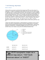
You want your compass and your GPS to be indicating the same kind of north (true or
magnetic). In the system setup, under “UNITS” you may want to set BEARING to
“MAG” (magnetic). This will cause the unit to display course / bearing information in
relation to the Magnetic North and match your magnetic compass readings (not
corrected for declination). It is not the same as True North! Many users select magnetic
north as zero degrees so they can follow a compass bearing without converting the
azimuth to true north. Many GPS units automatically calculate the local magnetic
variation (declination) for the fix time and date. Note: if your compass has a declination
adjustment (e.g., check out the Brunton Eclipse compass), you can alternatively set
your compass to do the conversation from magnetic north to true north by programming
in the declination indicated on your map. You can then set your GPS for true north.
Now, your map, your compass and your GPS will all be operating using true north (your
compass is now doing the conversion from magnetic north to true north). This is
essentially the same (within 2 degrees) of “grid north” shown on your gridded map.
Under “UNITS” consider setting to “METRIC”. Understandably, for many of us
“STATUTE” may be a more familiar option, but for working with UTM, it is best to get
familiar with the metric system. It corresponds directly with the UTM grids on the topo
maps. For the unfamiliar with the metric system, every time we mention “meter” think
“yard”, and you will not be that far off.
Always carry spare batteries for your unit. In the wild, don’t throw out the old ones. They
not only are a toxic waste, they might be able to provide enough power for one more
position fix, when your back-up battery set dies unexpectedly.
Nothing beats the real experience. Before leaving for less civilized areas, get a topo
map of your neighborhood. Practice navigation in a local park or conservation area.
After all, any excuse to be outdoors is good.
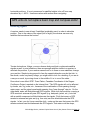
5. Grid Technology: UTM Grid & Gridded Topo Maps It turns out that the most confusing aspect of using a GPS is conceptual: what do those
numbers it gives you actually mean on a map. Your location on any topo map can be
specified with reference to a grid system. All USGS topo maps display two different grid
systems; latitude/longitude (L/L) and Universal Transverse Mercator (UTM). Most
people are probably already somewhat familiar with L/L (degrees/minutes/seconds
Chain Bridge District, National Capital Area Council, Boy Scouts of America Page 15