1
situations, which led to confusion about what exactly defines the BASINS system. These
and other needs have been addressed in this incremental release of BASINS.
The latest release of BASINS is version 3.1. Like the previous release, BASINS includes
a data extractor, projector, project builder, GIS interface, various GIS-based tools, a
series of models, and custom databases. But instead of including that data on multiple
CDs as in version 3.0, data are available entirely through a web data extraction tool. This
web data extractor provides a tool for dynamic downloading of BASINS data from a
variety of sources. Other significant enhancements in version 3.1 include a new tool to
archive and restore BASINS projects, updated data holdings, and a tool to update the
BASINS software interactively.
Access to data in BASINS 3.1 will be web based. The user will either download the core
system from an EPA web site or obtain a single CD containing BASINS software. The
user will then specify a geographic area of interest and the software will download
appropriate data from EPA, USGS and other locations on the Internet. Existing BASINS
users will be able to update, from the web, existing BASINS data sets and software by
using BASINS 3.1 components.
BASINS 3.1 Interface
BASINS can be viewed as a set of utility programs, analytical tools and associated data
under a metaphorical umbrella. A BASINS 3.0 user can run separate software products
based on the stage of the BASINS application process. The component-based design of
version 3.1 ties all of the BASINS components together through a single software
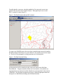
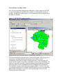
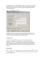
component, the BASINS ArcView interface (Figure 1). While being maintained as
separate programs for development and updating, having the components tied together
through a single interface gives the metaphorical umbrella over BASINS substance and
form.
Figure 1: The BASINS 3.1 Interface