1
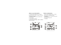
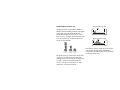
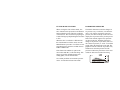
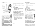
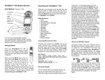
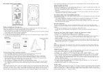
Speedtech Instruments
Model: ME-1
Speedtech Mariner’s EDGE
User’s Manual
INTRODUCTION
DISCLAIMER
Speedtech’s Mariner’s EDGE is a handheld
precision instrument which tracks tide heights
and times, sun and moon positions, barometric
pressure, and predicts fish feeding activity
based on those measurements.
The tide prediction is based on known data
such as sun and moon positions, along with
each port’s specialized “harmonic code”. Local
weather conditions can greatly affect tide
heights, including air pressure changes and
wind force. Accuracies of tide data from the
Marnier’s EDGE are within 15 minutes and 1
foot, when compared to printed charts.
HOWEVER, actual tide depth can vary.
FEATURES
• Present fish feeding activity, 1-10
• 4-hr future fish feeding activity forecast
• 96-year fish feeding activity based on future
sun and moon information
• Tide height and times
• Tide data for 2003 -2099
• Barometric pressure with 24-hr history
• Sunrise, sunset times
• Moon phase and position
• Weather forecast based on air pressure
• EL backlight
The Mariner’s EDGE has a port listing of 546
locations. The locations are for the US,
including Alaska, Hawaii, Cuba, Honduras,
and other select locations. Due to international
laws, the Mariner’s EDGE does not cover
Canada or other countries at this time.
The full port listing is shown on the separate
pages, listed in order by state.
SCIENTIFIC BASIS OF
FISH FEEDING FORECAST
Anglers and scientists alike identify several
key factors affecting fish behavior. For
centuries, fishermen have been aware that
moon phase and position relative to the earth’s
surface can greatly influence feeding activity.
Details of record game fish catches clearly
suggest that lunar phase has a bearing on fish
feeding activity, with specific lunar events such
as full or new moons being the most notable
times of good catch rates. This activity occurs
among both ocean-dwelling and freshwater
fish. The time of day and sun position are
important components as well.
Weather is another vital factor affecting fish
activity. Evaluations of bass and walleye
tournament summaries from across the United
States demonstrate the importance of local
weather patterns and events on fish behavior.
A wide range of other fish species, occupying a
variety of habitats, detect and respond to
barometric pressure changes associated with
weather patterns.
The algorithm developed for the Mariner’s
EDGE combines moon phase, and sun and
moon position, with barometric pressure
effects. All of these factors have been
combined into one comprehensive relationship
to predict fish feeding activity. The factors
used in the instrument were derived from a
variety of sources, including discussions with
meteorologists, fish biologists, anglers, and
extensive surveys of the scientific and popular
literature.
A combined total of over 40 years of fishery
research experience and personal observations
contributed to the development of the software
used in the instrument. All of this information
has been consolidated into the Mariner’s
EDGE to provide anglers with the ability to
determine the best times to fish.
INITIAL SET UP
Two CR2032 Lithium button-cell batteries
are included with your Mariner’s EDGE.
2. Using the provided small screwdriver,
remove the battery cover and insert the
batteries (positive side facing up), closing the
cover. Be sure to seat the rubber gasket
properly (this may take some patience).
3. Follow the SETUP guide to set the time,
date, coordinates and other settings.
1.
BASIC OPERATION
Refer to FULL OPERATION for detailed
instructions.
1. Press and hold the MODE button for 2
seconds to turn on (and off).
2. Press the TIME button to switch between
present and future modes.
3. Press the MODE button to cycle through
each screen of information
4. Press and hold the SET button for 2-seconds
to enter programming mode. Press the SET
button while in PORT NAME mode to
change the port.
5. Press and hold the TIME button for
2-seconds to activate/deactivate the button
lock.
6. Press the SET button briefly to turn on
backlight for five seconds.
Note: There will be a delay from scrolling from
the sunset to port name mode, during which
time the LCD will show a progress bar.
DISPLAY (NON-TIDE MODES)
DISPLAY (TIDE MODES)
A. Present fish feeding activity, 1-10 bars
A. Present fish feeding activity, 1-10 bars
B. 4-hour future activity (24-hour forecast in B. Port name or 24-hour tide chart
the future time mode)
C. Weather forecast (on present mode only)
C. Weather forecast (on present mode only)
D. Moon phase
D. Moon phase
E. Sun and moon position
E. Sun and moon position
F. Tide data
F. Time (this will change when the MODE
button is pressed)
-- SETUP PROCEDURES -INFO NECESSARY FOR SETUP
Proper set-up requires the local time and date,
time zone (hours from GMT), latitude and
longitude (in degrees and minutes), and
altitude. The Mariner’s EDGE requires sun and
moon positions, which are derived from
latitude, longitude and time zone. Barometric
pressure also affects fish behavior, and the
correct altitude must be entered to establish the
correct relative air pressure.
IMPORTANT (please read): The tide data is
derived from the local port name. When a port
name is entered, the latitude, longitude, and
time zone are automatically set. Changing
any of that information will result in the
deletion of the port name. The Mariner’s
EDGE can have TWO ports set; one in the
“present” mode, and one in the “future” mode
(which can be set to the present time and date).
There are cases when the location desired for
fishing is different than a location for tides. To
have the most accurate of both, it is
recommended to set the present mode to the
desired fishing coordinates, and the desired
port in the future mode.
TIME ZONE
The time zone setting is based on the deviation
from GMT (Greenwich Mean Time). If your
location follows Daylight Saving Time (DST),
the resulting time zone must be increased by
one during this time (summer time).
North American Time Zones:
Atlantic Time
-4 (-3 during DST)
Eastern Time
-5 (-4 during DST)
Central Time
-6 (-5 during DST)
Mountain Time -7 (-6 during DST)
Pacific Time
-8 (-7 during DST)
Alaska Time
-9 (-8 during DST)
Hawaii Time
-10 (-9 during DST)
degrees entry, and multiply the decimal by 60
to calculate the minutes. For example, 35.407°
The correct latitude and longitude is necessary
is 35 degrees, and 24 minutes (.407 x 60).
for proper sun and moon information. The
Note: the continental US lies within Latitudes
correct altitude is required for proper
adjustment of air pressure. When a port name N25° to N49° and longitudes W67° to W123°.
is set, the latitude, longitude, and time zone
will automatically be set; thus you may skip For locations in Canada, use the website
www.nrcan-rncan.gc.ca. For locations outside
this step. To locate local latitude, longitude
of North America, use www.mapquest.com or
and altitude, refer to a GPS unit, local airport,
www.world-gazetteer.com.
Note that the
or the internet. The easiest online source is
Mariner’s
EDGE
will
not
display
tides other
www.topozone.com. Choose “Get a Map” and
than
for
US
locations.
enter in your town and state. In the “Place
Name Search”, it will show elevation in feet
If there is trouble accessing your local
and latitude/longitude as a decimal. Double
click on the town name and a map will appear. coordinates, please e-mail Speedtech at
At the bottom of the map, select D/M/S. Then [email protected] for assistance.
look above the map for latitude/longitude in
degrees/minutes (pay attention to the direction
as well; North/South and West/East).
LATITUDE, LONGITUDE, ALTITUDE
If you know the latitude/longitude in decimal
degrees only, use the whole number for the
DETAILED SETUP
If unit is off, press and hold MODE button for
two seconds to turn ON. There is a set-up for
the present mode and for the future mode,
depending on which mode the unit is in when
the programming mode is entered (press the
TIME button to switch modes). It is best to set
the present mode settings first.
1. Press and hold the SET button for two
seconds to enter the set-up mode (skip to #2 if
setting future mode); “12Hr” will flash. Press
the – or + button to select 12Hr (AM/PM) or
24Hr (“military” time). Press SET button to
confirm.
2. The hour will flash. Press the – or + button
to set the current hour (note AM or PM if in
12Hr mode). Press the SET button to confirm.
3. The minutes will flash. Press the – or +
button to set the current minute. Press the SET
button to confirm.
4. The month will flash. Press the – or +
button to set the current month. Press the SET
button to confirm.
5. The day will flash. Press the – or + button
to set the current day. Press the SET button to
confirm.
6. The year will flash. Press the – or + button
to set the current year. Press the SET button to
confirm. Skip to 9 for future mode.
7. (Present mode only) The pressure unit
(inHg or mb) will flash. Press the – or + button
to select inHg or mb. Press the SET button to
confirm.
8. (Present mode only) The altitude unit will
flash. Press the – or + button to select ft or m
(meters). This is for the altitude input for
pressure adjustment, and tide heights. Press the
SET button to confirm.
**If a port has already been selected, the
correct latitude, and longitude will be
programmed. Changing these values will
clear the port selected. The correct time
zone will also be programmed, however
during daylight saving time it is necessary to
advance by one.
9. The time zone will flash. Press the – or +
button to set the local time zone. Press the SET
button to confirm.
10. The latitude direction will flash. Press the –
or + button to set N (North) or S (South). Press
the SET button to confirm.
11. The latitude degrees will flash. Press the –
or + button to set the latitude degrees. Press the
SET button to confirm.
12. The latitude minutes will flash. Press the –
or + button to set the latitude minutes. Press the
SET button to confirm.
13. The minutes will flash. Press the – or +
button to set the current minute. Press the SET
button to confirm.
14. The longitude direction will flash. Press the
– or + button to set W (West) or E (East). Press
the SET button to confirm.
15. The longitude degrees will flash. Press the –
or + button to set the longitude degrees. Press
the SET button to confirm.
16. The longitude minutes will flash. Press the
– or + button to set the longitude minutes.
Press the SET button to confirm.
17. (present mode only) The altitude
compensation will flash. Press the – or + button
to set the local altitude (in feet or meters, as
selected in step 8). Press the SET button.
The set up is now complete. Please refer to
the “TIDE FUNCTION” instructions to set
the port name.
Note: If you press once, each step goes as 1
meter; if you hold + or –button for 2secs,
if will go fast forward or backward.
Note: the future time and date can only be set
for a time and date in the future or current time
and date. If a past time and/or date is set, the
time and date will default to the current set
time and date. The future mode will allow for a
different port name to be entered.
-- OPERATION AND FEATURES -DISPLAY MODES
Press the MODE button to scroll through
information, in either present or future modes;
no pressure will display in future mode.
TIME → DATE → YEAR → PRESSURE
→ SUNRISE → SUNSET
→ PORT NAME
→ TIDE HEIGHT RANGE
→ HIGH TIDE HEIGHT AND TIME
(alternating when two high tides exist)
→ LOW TIDE HEIGHT AND TIME
(alternating when two high tides exist)
→TIME
When in pressure mode, the graph at the top
will display 24-hour history.
When in tide modes, the graph at the top will
display 24-hour for that day tide height, as a
percentage of the total tide height.
The display will revert to the time display if no
buttons are pressed for one minute and will
turn off when no button is pressed for five
minutes (all settings remain, and air pressure is
still tracked).
TIDE FUNCTIONS
Speedtech’s Mariner’s EDGE has 546 ports
stored internally. While there is no option to
add more ports once a unit has been made,
every effort has been made to include the most
significant ports around the US.
PORT NAME (SEE LIST ATTACHED)
The following can be done in both present
and future modes.
1. Press and release the MODE button until
the PORT name mode is displayed (there will
be letters or dashes in the top section).
2. Press and hold the SET button for two
seconds. The first alpha-numeric code will
show a flashing underline.
3. Press the – or + button to scroll through the
available letters or numbers. Note that the
letters cannot be set to any letter, only for
those listed. Press the SET button to confirm
the first letter.
4. Press the – or + button to scroll through the
available letters or numbers. Press the SET
button to confirm the second letter.
5. Press the – or + button to scroll through the
available letters or numbers. Press the SET
button to confirm the third letter.
6. Press the – or + button to scroll through the
available letters or numbers. In some cases the
last letter cannot Press the SET button to
confirm the fourth letter.
TIDE MODES
By pressing the MODE button, the Mariner’s
EDGE will scroll through the tide information
screens in sequence.
STATUS BAR
TIDE RANGE
There may be a short delay when the Mariner’s
EDGE enters the tide mode. This will occur
when a date change has occurred, or a different
port is selected. The status bar will display at
the top.
RANGE
PORT NAME
The first screen displays the PORT name
setting, along with the current time.
The upper section will display the 24-hour
future tide height, as a percentage of highest
tide height. In the TIDE RANGE mode, the
total tide range will be displayed in feet or
meters. This is the lowest tide height subtracted
from the highest tide height; thus the range will
not necessarily be the highest tide (for
example, a high tide of 8.4 m and a low tide of
1.0 m is a tide range of 7.4 m).
HIGH TIDE HEIGHT AND TIME
OTHER TIDE FUNCTIONS
In tide modes, the fish feeding forecast for the
current time is displayed (whether in present or
future mode), on the right side of the LCD. The
The display will show the time of the high tide,
moon phase and sun and moon position are
on the left side, and the height of the high tide,
displayed also. The weather forecast icon is
on the right side, for the next 24-hour period.
displayed in present mode only.
In many areas there are two high tides in a 24hour period, and this display will alternate
The future mode operates in a similar manner
between the two times; take note in AM or PM, to the present mode. In future mode, the set
unless military time is used.
time can be scrolled ahead or backward hourby-hour, across dates (from 11PM to 12AM).
LOW TIDE HEIGHT AND TIME
The future time and date can actually be the
same as the present time and date, which
allows two ports to be accessible easily.
The display will show the time of the low tide,
on the left side, and the height of the low tide,
on the right side, for the next 24-hour period.
In many areas there are two low tides in a 24hour period, and this display will alternate
between the two times; take note in AM or PM,
unless military time is used.
FISH FEEDING FORECAST
The unique feature of Speedtech’s Mariner’s
EDGE is the fish feeding prediction. The graph
on the right side of the LCD displays the
present fish feeding activity level, on a scale
from 1 (low) to 10 (high). In present mode, this
is for the current time; in future mode, this is
for the set time and date.
MEDIUM
LOW
HIGH
FISHING FISHING FISHING
ACTIVITY ACTIVITY ACTIVITY
The graph at the top of the LCD (except when
viewing air pressure) shows the future fish
feeding activity. The current level is displayed
as “0 Hr” on the left. In present mode, the
activity is for the next four hours; for future
mode this is for the next 24 hours.
Present 4-hour graph:
Future 24-hour Graph
Note that the “future” mode may be set for any
time and date through 2099, including the
current time. The fish feeding activity based on
sun/moon position only.
FUTURE MODE FEATURES
BAROMETRIC PRESSURE
The built-in barometer senses the changes in
air pressure every 15 minutes, even when the
unit is “off”. When viewing the current air
pressure, the chart on the top of the LCD will
display the air pressure history for the past 24
hours. Each column, right to left, represents
one hour in the past. Each dot represents a
When the time is scrolled to a different time,
change in air pressure, up or down, relative to
the tide information will also track, once the
the current air pressure, or “0 Hr”. To read the
MODE button is pressed to view those screens.
graph, follow the chart from left to right. The
Note that the time cannot be scrolled when in
graph will increase when the air pressure rose,
PORT NAME mode.
and decrease when the pressure fell. The
pressure trend for the past 6 hours is the most
If the future time and date is equal to the
current time and date, it will track along. This useful for short-term weather forecasting.
feature is good for planning shorter-term
fishing plans, over the next 24 hours.
When viewing the time in future mode, the –
and + buttons can be pressed to scroll ahead or
backward hour-by-hour. The time scrolled to
will remain set. This is useful for preparing for
a future fishing trip and planning the best times
to fish.
No weather prediction or barometric pressure
can be viewed when in future time mode.
WEATHER FORECAST
SEVERE WEATHER WARNING
The Mariner’s EDGE measures changing air
pressure and predicts short-term changes in
weather over a small area. In general, falling
air pressure results in worsening weather, and
rising air pressure results in fairer weather.
Rapidly falling pressure signals an approaching
storm, while rapidly rising pressure will result
in strong winds. The weather forecast is for the
next 6 to 12 hour period, over an area of 20 to
30 miles. The accuracy of any pressure-based
forecast is about 75%, although less in areas
where pressure does not affect weather as
much.
By definition, severe weather occurs when
barometric pressure changes by 6 millibars
(up or down) during a three hour period.
Severe weather, including wind and rain,
generally accompanies falling barometric
pressure. Rising pressure will result only in
high winds.
SUNNY
PARTLY
CLOUDY
CLOUDY
RAINY
When severe weather is detected, the unit will
give an audio warning and flash the weather
icon. The alarm is muted by pressing any
button. The alarm functions and will sound,
even if the unit is off, unless this feature is
disabled.
To disable the severe weather warning, press
and hold the – button for three seconds while in
present mode. A beep will sound once. To
activate the alarm, press and hold the + button
for three seconds while in present mode. A
series of three beeps will sound.
MOON PHASE
The moon phase is indicated in eight symbols,
as shown below. The moon phase is for either
the present date, or for the set future date,
depending on which mode is viewed.
New moon
Waxing crescent
First quarter
Waxing gibbous
Full moon
Waning gibbous
Last quarter
Waning crescent
The exact sunrise and sunset times can be
located by pressing the MODE button and
cycling through the modes, in either present or
future mode.
W
E
MOON
RISE
W
E
SUNRISE
W
E
W
MOON
OVERHEAD
W
E
SUN
OVERHEAD
E
MOON
SET
W
E
SUNSET
W
E
MOON
UNDERFOOT
W
E
SUN
UNDERFOOT
NOTE: If the sunrise and sunset times (also
sun/moon position) appear to be off by an hour,
SUN AND MOON POSITIONS
check to be sure the correct time zone is set,
A useful feature of the Mariner’s EDGE is the taking into account daylight saving time. If it
chart displaying sun and moon positions. Once appears to be off by more than an hour, check
understood, the current positions of the sun and the Lat(itude) and Lon(gitude), including the
direction.. In the US, Lat should be N(orth)
moon can be determined at a glance. The
center circle represents the earth, with the sun and Lon is W(est).
and moon revolving from East (rising) to West
(setting).
KEY LOCK
BELT CLIP, CARRY POUCH
The buttons may be locked to prevent
accidental changes. Press and hold the TIME
button for two seconds to activate/deactivate
the key lock.
A belt clip (which can also be used as a
mounting bracket) is attached and can be
removed if desired. A carry pouch is also
included to protect the unit from the elements.
CONDITIONS AFFECTING ACCURACY
MAINTENANCE
When the unit is subjected to a change in
altitude, which can occur when ascending or
descending a building or when traveling across
uneven terrain, the pressure readings are
affected. Since the present fish feeding
prediction, weather forecast, and severe
weather alarms rely on changing air pressures,
those readings should be ignored until the
altitude has been steady for two to three hours.
Also be sure to set the altitude adjustment to
the current altitude (if known).
The Mariner’s EDGE is designed to withstand
moderate elements, but like most electronic
devices should be handled carefully to avoid
damage. Do not submerge in water.
WARRANTY
Speedtech’s Mariner’s EDGE is warranted
against manufacturing defects for one-year.
This does not cover physical damage as a result
of misuse. Please refer to the instructions or
contact us for answers and assistance.
Speedtech Instruments
45449 Severn Way #165
Sterling, VA 20166
703-430-8055
703-430-8066 (fax)
9:00 – 5:00 pm EST, M - F
[email protected]
www.speedtech.com