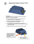
1
TSWS 1.4
Tracking System Work Station
---------- Installation
and User Manual ----------
1
Proprietary Notice and Disclaimer
License Agreement
Unless otherwise noted, this document and the information herein disclosed are proprietary to Star Network Technology
Limited (SNT). Any person or entity to whom this document is furnished or who otherwise has possession thereof, by
acceptance agrees that it will not be copied or reproduced in whole or in part, or used in any manner except to meet the
purposes for which it was delivered.
The information in this document is subject to change without notice, and should not be construed as a commitment by
SNT. Although SNT will make every effort to inform users of substantive errors, SNT disclaims all liability for any loss
or damage resulting from the use of this document or software described herein, including without limitation
contingent, special, or incidental liability.
Copyright © 2006 Star Network Technology Limited
Read this agreement before opening the software. Once you have removed the software from its envelope or
downloaded from the SuperGuard website you have accepted the agreement.
USAGE RIGHTS
Your rights, with respect to the Software, are non-exclusive. The software may only be used by one user, on one
computer at a time. The software may be transferred to another computer, as long as it is only used by one user at a
time. The Software and its documentation may not be copied or distributed to others. You may not create, modify, alter,
adapt, merge, decompile, or reverse-engineer the Software, and you may not remove or obscure SuperGuard logos or
other included copyright or trademark notices.
COPYRIGHTS
The Software accompanying this manual is protected by copyright laws of the United States and Hong Kong (SAR).
The Software documentation is copyrighted. You may only copy the Software and the Software documentation for
backup or to load the Software onto your computer as part of program execution.
TITLE TO SOFTWARE AND CONFIDENTIALITY
The Software and all copies thereof are proprietary to SNT and title thereto remains in SNT All applicable rights to
patents, copyrights, trademarks and trade secrets in the Software are and shall remain in SNT. You may not sell,
transfer, publish, or otherwise make available any software or copies thereof to others. You acknowledge that the
Software is a trade secret of SNT. You agree to secure and protect each program, software product and copies thereof in
a manner consistent with the maintenance of SNT’ s rights therein and to take appropriate action by instruction or
agreement within your organization to satisfy your obligations hereunder. Violation of these provisions shall be a basis
for immediate termination of this license. Termination of the license shall be in addition to and not in lieu of any other
legal or equitable remedies available to SNT.
SOFTWARE LIMITED WARRANTY
ALL SOFTWARE FROM SNT IS PROVIDED “AS IS” WITHOUT WARRANTY OF ANY KIND, EITHER
EXPRESSED OR IMPLIED, INCLUDING BUT NOT LIMITED TO THE IMPLIED WARRANTIES OF
MERCHANTABILITY OR FITNESS FOR A PARTICULAR PURPOSE.
SNT does not warrant that the functions contained in the Software will meet all your requirements or that the operation
of the Software will be uninterrupted or error-free. However, SNT warrants the CD-ROM on which the Software is
furnished to be free from defects under normal use for a period of ninety (90) days from the date of delivery as
evidenced by a copy of your paid invoice or sales receipt. If the CD-ROM fails due to neglect, accident, or abuse, SNT
shall not be liable to replace the CD-ROM under this Limited Warranty. SNT’s entire liability and your exclusive
remedy for a diskette not meeting SNT’s Limited Warranty will be the replacement of such diskette which is returned to
SNT or to an authorized dealer with a copy of your paid invoice. In no event will SNT be liable for any damages,
including any lost profits, or other incidental or consequential damages arising out of the use or performance of the
Software, even if SNT or an authorized dealer has been advised of the possibility of such damages.
This Limited Warranty gives you specific legal rights. You may have additional rights, if you entered into an individual
license agreement or maintenance program with SNT. In such cases, the rights an liability features furnished to you will
exclude and exceed all terms of this Limited Warranty.
You acknowledge that you have read this Agreement and understand it, and agree to be bound by its terms, and further
agree that it is the complete and exclusive statement of the Agreement, which supersedes and merges all prior
proposals, understandings and other agreements, oral and written, between the parties to this Agreement. This
Agreement may not be modified or altered except by a written instrument duly executed by both parties. This agreement
and performance hereunder shall be governed by and construed in accordance with the laws of the Special
Administrative Region of Hong Kong.
If any of the provisions, or portions thereof, of this Agreement are invalid under any applicable statute or rule of law,
such invalidity shall not affect the validity of the balance of this Agreement, and such provisions or portions thereof are
to the extent of their invalidity to be deemed omitted from this Agreement.
2
3
TABLE OF CONTENTS
1.
Introduction
2.
Control Base – Basic Functions
Application – Overview
Main Menus – Overview
Main Toolbar – Overview
Control Panel – Overview
History Panel – Overview
Search Panel – Overview
Online Panel – Overview
Device Status Log – Overview
AD Controller Panel – Overview (only for ADC models)
Eagle Map Window – Overview
7
7
8
9
10
12
13
14
14
16
16
3.
Glossary
17
4.
Installation – Preparations
Recommended System and Hardware Requirements
System Preparations
18
18
18
5.
Installing the Tracking System Software
19
6.
Configuring Modem Connections
Preparing GSM Connection
Preparing 56K Modem/ DTMF Connection
Modem Configuration
22
22
22
23
7.
Configuring GPRS and Data Connections
27
8.
Adding Maps and Map Services
Map Display Options
Configuring GIS Server Connections
28
29
31
9.
Adding User Accounts to the Database
How to Create User Entries
Other Accounts Manager Features
How to Create Group Accounts
32
32
36
37
10.
Initializing GPS Devices
Initializing Devices from the Control Base
39
39
11.
Configuring GPS Devices
Setup Geo-Fence Areas for a Device
Setup Power Saving Modes
Setup GPS Storage Sequence for a Device (AVL Models)
39
40
41
42
12.
Using the Map Tools
Using the POI Creator
43
45
4
6
13.
Using the Search Functions
Searching for a Place or Object
Searching for a Near Place or Map Object
Finding the Shortest Path and Routing
46
46
47
48
14.
Using the Location and Tracking Commands
Locating and Tracking a Device
Configuring a Tracking Schedule
50
50
51
15.
Using the History Log and Records
Using the Tracking History Log
Maintaining the History Database
Using the Communication Record
Using the SMS Record
Using the Alarm Record
53
53
57
58
60
61
16.
Accepting Events
Types of Events (SOS Emergency/ Geo-Fence/ Speeding/ Battery Low
Vehicle Security Alerts (AVL Models)
63
63
64
17.
Activate/ Disable Vehicle Security
66
18.
Using the SMS Editor
66
19.
Configuring the Vehicle Data Collector (ADC only)
67
20.
Online Software Updates and Upgrading Devices
Download and Installation of Software Updates
Sending Firmware Upgrades to Devices
70
70
71
21.
Testing Devices with the Diagnostic Program
72
5
1. Introduction
The TSWS 1.3 Control Base software for use with GPS location and tracking devices consists
of an advanced, multifunctional geographic information system with GSM and GPRS
communication interface for short message commands and data exchange. It allows you to
manage and remote operate all types of GPS tracking devices operating under the
SuperGuard logo from a single PC desktop.
2. Control Base – Basic Functions
Application – Overview
Menu Bar
Toolbar
Map Window
Controls
( GPRS Online Monitor/ Control Panel/
History Log/ Search Panel/ AD Controller
The TSWS 1.3 WorkStation software will enable you to:
-
Choose and view detailed vector maps in street level, points of interest and additional
information,
Zoom, pan and print map extents,
Do multiple search for geographic areas, roads, points of interest and other map items,
Define and find specific map items near to a location,
Calculate and display the shortest or fastest route between two points,
-
Setup new user accounts and user groups
Send SMS commands and text messages,
Locate, monitor and control up to 25 tracking objects in real time,
Manage tracking history and user database,
Setup up to four individual Geo-fence for each tracking object,
Setup parameters and initialize new GPS devices wireless,
Remote operate vehicle security systems,
Run test program and device upgrades wireless over GPRS.
Device Status Log
6
Eagle Map
7
Main Menus – Overview
File – Print
File – Export
File – Exit
allows you to print the current map extent on a printer.
allows you to save the current map extent to a Bitmap (.bmp) file.
lets you exit the program and end all activities.
Map Tools – Point
changes your mouse cursor from functional tool to default
pointer.
Map Tools – Zoom In
lets you select an area to zoom into the map.
Map Tools – Zoom Out
lets you zoom out from a map area.
Map Tools – Pan
lets you grab and move the map.
Map Tools – Full Extent
lets you view the complete map.
Map Tools – Measure Length opens tool to manually measure distances in map.
Map Tools – View all Status in Area allows you to view the device status and information of all
selected tracking objects within a specified area.
Map Tools – Show and Draw GeoFence opens database to select device and lets you define
Geo-fence areas.
Map Tools – Hide GeoFence hides all Geo-Fences displayed in map.
Map Tools – Remove GeoFence lets you remove Geo-Fences settings for selected devices.
Map Tools – Add New Map lets you add a new map from the local map database.
View – Unit Status
lets you open or close the Device Status Log.
View – Control Panel
lets you open or close the Control Panel.
View – Scale Bar
lets you open or close a metric scale in the current map extent.
View – Compass
lets you open or close a North indicator.
View – Communication Record lets you open a database record set with all incoming and
outgoing communication details
View – SMS Record
lets you open a database record for all inbound and outbound
SMS and SMS costs.
View – Alarm Record
lets you open a database record set with all alarm information
Manager – Group Settings
opens the group user database for searching, adding, changing
or removing group entries.
Manager – Accounts Settings opens the device and user account database for searching,
adding, changing or removing user accounts.
Manager – Vehicle Type Settings lets you enter vehicle specific data (for ADC only).
Manager – SMS Settings
lets you setup and choose SMS sending modes.
Manager – Modem Settings lets you configure your COM ports and GSM SIM card
information
Manager – GPRS Settings lets you define port for GPRS socket and default communication
ports for TCP/IP data exchange
Manager – Other Settings lets you change Fonts and font size for map display, SMS text
language, Control Panel options and third-party WorkStation
connection
Help – Online Upgrade
Help – About
8
connects to the Online Upgrade WorkStation to receive TSSR 3.1
updates.
displays current software version and installed hardware
upgrades.
Main Toolbar – Overview
The Print tool allows you to print the current map or map extent on a printer.
The Export Map tool allows you to save the current map or map extent to a Bitmap
(.bmp) file.
The Point tool changes your mouse cursor from functional tool to default pointer.
The Zoom In tool lets you select and zoom into a map area.
The Zoom Out tool lets you zoom out from a map extent.
The Pan tool lets you grab and move the map.
The Full Map tool lets you view the complete map.
The Measure Length tool lets you manually measure distances in map.
The View All Status in Area tool allows you to view the device status and information of
all selected tracking objects within a specified area.
The Show&Draw GeoFence tool lets you show and define Geo-Fence areas for selected
devices
The Hide GeoFence tool lets you hide all Geo-Fences displayed in map
The Remove GeoFence tool lets you remove Geo-Fences settings for selected devices.
The Geo-Fence mode lets you select the options for Geo-Fence alerts: ‘Alert when In’
for inbound alarms, ‘Out’ for outbound and ‘In/Out’ for border crossing alarms
Show POI lets you view all points of interest (POI) you have created and stored to your
database on the map
Hide POI hides all POI in the map
Add POI lets you create and label new points of interest in the map
Edit POI lets you rename, move or delete POIs to a different location
The map menu lets you select maps from the local map database
Add new Map lets you load new maps into your map database (Note: This feature only
applies for map databases working with local map engine).
Group Settings opens the group user database for searching, adding, changing
or removing group entries.
Accounts Settings opens the device and user database for searching, adding, changing
or removing user entries.
Vehicle Type Settings lets you setup a vehicle database used for speed calculations based
on pulse and wheel diameters (ADC required)
SMS Settings lets you setup and choose SMS modes.
Modem Settings lets you configure your COM ports and GSM SIM card information
GPRS Settings lets you define port for GPRS socket and default communication
ports for TCP/IP data exchange
Other Settings lets you change Fonts and font size for map display, SMS text
language, Control Panel options and third-party WorkStation connection
9
Control Panel – Overview
The Control Panel enables you to send tracking commands, configure GPS Tracking devices,
activate security features and run the test diagnostic program.
The TSWS 1.4 automatically switches between different SMS Control Panels for different
devices (Personal Tracker models, Vehicle Tracking devices, etc.), according to device
selections made in Accounts Settings.
ID:
Phone:
lets you select and control all GPS devices
from your user database. To refresh
device list, click Refresh Unit List
button . Click the Initialize unit button
to send user information and settings
to the selected GPS unit. To initialize
Geo-Fence areas you have drawn before,
click Initialize Geo-Fence .
To enter the device diagnostic program,
click Diagnostic . Click Upgrade Device
to transfer new firmware upgrades to
the device over GPRS.
shows the phone number from the SIM
card used in the device. All SMS
commands or SMS text messages will be
send to this number.
Get Location (PT2 Controller) sends a command to the
device to receive current GPS position
and status information, to be displayed on
the map. To get one single location from a
Vehicle unit in an AVL Panel, click Query
Last Status button
instead.
Diagnostic
starts the testing and diagnostic program
to monitor GPS satellite availability, GSM signal strength and other test
features.
Track Time
lets you setup a tracking period over which you like to receive positions from a
device. You can choose a time ranging from 1 minute to 45 days, using the M
(minutes) H (hours) D (days) menus.
Track Interval lets you setup the interval in which you like to receive positions from the
device, over the tracking period setup in Track Timer. To send the Track Timer/
Interval command to the GPS unit and start tracking, click the Start Track
button
. To abort tracking before the Track Timer is up, click Stop Track .
To only use GPRS for tracking location reports from device to WorkStation,
click Tracking Only by GPRS. If you wish to use SMS fallback in case no GPRS
is available, click Tracking by GPRS/ SMS.
Saving (PT2 Panel) lets you configure battery saving modes for Personal Tracking devices.
Choose GPS Always On (default) to disable shut-off timer for GPS engine.
Choose GPS Always Shutdown to turn the GPS engine off. It will be activated
only if the device is been interrogated through tracking commands or the
emergency button has been pressed. To turn on the GPS engine in a specific
time interval, select a Wake up Time between 60 seconds and 42 minutes. To
initialize the device with the power saving settings, click Initialize Saving Mode.
Security (AVL Panel) lets you remote activate the Vehicle
Unit’s car security features. To turn on
security, click Activate
. To turn off
security features, click Disarm .
Click Query Status
to receive location and information about the current
status of the car security.
Device Status Storage (AVL Panel) lets you setup a storage
interval (10 sec – 42 min) in which the unit
shall store GPS positions and status data to
its memory. To activate data storing, click
Start Store
. To stop the unit from storing
data, click Stop Store .
To manually upload all data from its memory to the history database and clear
the unit’s memory, click Upload Now (GPRS required).
To setup a scheduled upload of all GPS and status data stored in the device,
select an Upload Interval (min. 30min) and click Scheduled Upload. To stop
automatic uploads from the device, click Stop Scheduled Upload.
(S-19B/WebTrac-4 Panel) Click Initialize Unit button to
send initialization information to the device
(you will need to enter correct factory Device
Password and IMEI when you create the
account in Accounts Manager).
To activate or disable the preset Geo-Fence
area around the device, click Activate
Park/Unpark button.
If you wish to change the Device Username
or Device Password, enter new information
in the user account first (Accounts Manager). To configure the device with new
user name and password, enter factory configurations into Original Username
and Original Password, then send these commands using the Change Device
Username and Change Device Password buttons.
To manually start Real-Time-Tracking over GPRS (with position updates every
10 seconds), click Start RealTime Tracking , to end Real-Time-Tracking, click
Stop RealTime Tracking .
10
11
Message
lets you write and send SMS text messages to a
number you have entered in the Phone: field.
The GSM monitoring box at the bottom of the Control Panel
displays activities and short status information of connected
GSM modems or terminals, indicating SMS sent and received.
Search Panel – Overview
The Search Panel enables you to search a map for places, street names and landmarks, find
near locations and calculate the shortest route and distance between two points.
Search Layer lets you specify the type of map objects
you are searching for.
Search Key
History Panel – Overview
The History Panel enables you to review, search, save and retrieve positions end events
received from GPS devices and stored in the history database.
The Search Results window will display the
names of all objects found according to your
search parameters. Choose from the list and
double-click to view the item on the map.
From the Tracking History Time menu, choose a time
period to view the tracking history.
From the Device menu, choose a Device ID or view history
of All Devices from your database.
From the Status field, select if you want to view the
complete history database or only the history connected to
an event.
From the Event Completed menu, filter the events that have
not been completed or accepted yet.
The History log allows you to view all positions, status and
events according to the parameters you have selected in the
fields above.
Click on a table row if you want to view this position and
date on the map. Click at the table headers to reorganize
the order of history entries. To scroll through all pages of
the history database, use First, Previous, Next and Last
page.
Click Show Tracking History In Map to select a time period and view the history track as
colored line in the map window.
Click Hide Tracking History in Map to make the track line disappear from the map.
Click Backup Database to define a time interval in which data entries from the history log
shall be saved to your database.
lets you enter the name or parts of the name
of the location or object you are searching
for. Click the Start Search button
to start
the search.
Search Nearest allows you to locate a place or object next to
a given point or name. Click Nearest from
Search Result to start from the Search
Results window. Use Click Start Point in Map
to manually set a start point on the map.
Click Search Nearest to start your search.
Navigate
enables you to calculate and display the
shortest distance and route between two
points in the map. To start navigation from
the current position of a device, select the
Device ID by clicking on the relevant row in
the Device Status Log. Click the Start from Device button
to mark the
starting point. Click Start from Search Result
if an object from the Search
Result window shall mark the starting point. Click End at Search Result if
the Search Result shall mark the end point of the route. Choose Click in Map to
Set Start to manually set a starting point on the map through mouse click.
Choose Click in Map to Set End if you want to manually set the end point on
to start route
the map through mouse click. Click Find Shortest Path
calculation and receive directions. Click Begin Navigation to receive audio
directions during Real-Time-Tracking (currently only available for use with Asian
map database).
The Shortest Path Results window will display the complete route and direction (street
names)
between the two points and the distance in meters. In addition, a colored line will show the
route on the map window.
To hide search results and routes in the map window, click Hide All Found In Map.
Click Import Database to load previous history files from your database.
12
13
Online Panel – Overview
Device ID
The GPRS Panel enables you to monitor TCP activities over the GPRS socket, used for
communication with GPRS enabled tracking devices.
Time(GMT)
Field
helps you searching for devices from your
user database according to specific
parameters.
GPS Available
Search
lets you enter the name or parts of the name
you search for in conjunction with the
parameters set above. Click the Search User
button
to start the search.
To view all users of your database, click
Show All Users
.
All active devices that are currently online and
communicating over GPRS socket, will be
shown with yellow light bulbs adjacent to the
Device Ids.
Grey light bulbs indicate that no GPRS connectivity is
recorded.
If units are currently being upgraded with new firmware
versions, the download status can be
monitored at the Upgrade bar.
LBS Position
Door Lock
Active
Engine Off
ACCIn
SOS
Crash
Door Open
Battery Low
Device Status Log – Overview
The Device Status Log shows all current activities and events happening to the GPS devices
from your database. Use the scroll bars to move through the complete table.
Shock
Out of Area
Request
Speeding
Power Removed
Illegal ACC
The following page shows entries to the Device Status Log that will be made for every
incoming data set (entries in grey are only applicable for AVL in combination with vehicle
data collector):
14
Unauthorized
Number
Voltage Alarm
Displays the device number
from the user database
Displays the satellite time
(GMT) at the time of
record
Shows if GPS was available
to the device at the time of
record
Indicates if the incoming
position was received
through Location Based
Services
Shows the status of the
central door lock system
Shows the status of the car
security system
Voltage Down
ADC Scanning
Shows when one voltage
drops unusually
Indicates if a data collector
device is connected
ADBoard Error
Shows if the data collector
is malfunctioning
Latitude
Displays the latitude from
the GPS data
Longitude
Displays the longitude from
the GPS data
Displays the actual speed
(in knots) from the GPS
data
Displays the direction from
the GPS data
Shows if an event has been
recorded
Shows if an event has been
accepted by the operator
Displays the actual
firmware version of the
device
Displays the last measured
pulse count
Speed
Shows the status of the
immobilizer function
Shows if the Ignition is
currently switched on
Shows if an SOS call has
been triggered
Shows if the vehicle has
been hit or rammed
Direction
Shows if the doors have
been opened in armed
status
Shows if battery power is
low
Shows if the vehicle is
being moved in armed
status
Shows if the vehicle
violated a Geo-Fence
Shows if the request button
of the Vehicle Unit has
been pressed
Shows if the maximum
speed limit has been
exceeded
Shows if main power
source had been cut (car
battery)
Shows if the ignition line
has been bridged
Indicates if an
unauthorized SIM number
is used
Shows when a voltage
irregularity is measured
Pulse
Has Event
Completed
Version
Voltage1
Voltage2
Voltage3
Voltage4
Displays the voltage
measured on Input 1
Displays the voltage
measured on Input 2
Displays the voltage
measured on Input 3
Displays the voltage
measured on Input 4
Digital Input1
Shows if a digital input is
present on 1
Digital Input2
Shows if a digital input is
present on 2
Digital Input3
Shows if a digital input is
present on 3
Shows if a digital input is
present on 4
Digital Input4
15
AD Controller Panel – Overview (only for ADC models)
The AD Controller Panel enables you to define voltage minimums, maximums and voltage
drop limits for every ADC vehicle data collector input, reset pulse counter and view average
speed and voltage reports.
AD Settings
For each voltage input V1 (Fuel), V2, V3 and
V4 you can define voltage minimum alarms
(Lower), maximum alarms (Upper) and
irregular voltage alarms (Drop). Check conn
to activate or disable the Input line.
3. Glossary
Command
Digital instruction send by an Map Object
operator or user, to perform
a specific function or
operation.
Device Status
A set of GPS and status
information data received
from a tracking device,
containing GPS data
(Longitude, Latitude,
Velocity, Time), event and
activity indicators.
A restricted, user-defined
geographic area. If a GPS
device leaves or enters the
predefined area, an alarm is
triggered.
Map Tools
Geographic Information
System. A Geographic
Information System is a
combination of elements
designed to store, retrieve,
manipulate, and display
geographic data information about places.
(Global Positioning System).
A system of satellites that
transmit continually, which
make it possible to locate
tracking objects within an
accuracy of 15m through a
receiving unit.
General Packet Radio
Service: A GSM data
transmission technique able
to transmit data rates from
56 up to 114 Kbps. Users pay
only for the volume of data
sent and received.
(Global System for
Communication), is a
globally accepted standard
for digital communication,
using a cellular network.
SMS
Click Save and Initialize Voltage to send all
configurations to the device.
To connect or disconnect the ADC module,
click Start Communication or Stop
Communication.
Geo-Fence
To reset the pulse counter to Zero, click Clear
Pulse.
AD Chart
lets you view graphs and charts for Speed/
Odometer readings, Fuel consumption and
full reports.
Select a Begin Time and End Time for which
you want to view the report and click
Speed/Odometer Chart to view the average
speed chart for the selected period.
To receive a detailed chart about the fuel consumption (V1 Input), click Fuel
Chart.
To view all current voltage status, click Current AD Status Chart.
Eagle Map – Overview
The Eagle map window shows the position of the
current map extent from the main map in a lower zoom
level, making it easier for you to know the overall
location of a current position on the main map. Use the
mouse to pan and move the current map extent.
16
GIS
GPS
GPRS
GSM
Operator
A point, line or shape on a
digital map layer, containing a
name and geographic
information (e.g. countries,
rivers, districts, streets,
buildings, parks)
A system of tools that allow
you to view map extents, zoom
in or out, or search map layers
for contents.
A person or team authorized to
operate and control the
software and WorkStation
features, administrate user
accounts and incorporate
additional services
(Short Message Service)
Mobile phone text service, that
lets operators and users send
text messages and commands
through GSM cellular
network.
User
The customer or subscriber,
using products and services
provided by the operator.
Tracking
Device
A GSM/ GPRS/ GPS enabled
unit that is able to receive,
store and transmit GPS data,
recognize and implement
commands, and perform
various security and safety
functions.
17
4. Installation - Preparations
5. Installing the Tracking System Software
Recommended System and Hardware Requirements
The Tracking System WorkStation is designed as a stand-alone tracking system with
integrated map engine and database management.
To install the TSWS 1.3, your PC is required to meet the following minimum system
requirements:
-
Pentium 4 Processor 2.00 GHz
Operating System: Microsoft Windows 2000 or higher, Windows XP)
RAM 512 MB
Graphic Card 16 MB (or higher)
Broadband Internet connection (optional for use with GPRS devices)
Fixed (real) IP address (optional for use with GPRS devices); 1 free internet port (not
firewalled)
Free Disk Space for Control Base software: 25 MB (without maps)
GSM Terminal (preferred Siemens TC 35 or higher)
SMS enabled GSM SIM card
The installation of the TSWS 1.3 WorkStation on your PC will create program group
items for running and operating GPS tracking and database management.
During Setup and Installation you can choose if you want to install the software in a different
location or program group.
To install Tracking System WorkStation, follow these steps:
1. Download or copy the complete “TSWS 1.3 Setup” folder to a hard drive on your PC.
2.
Install the Tracking System WorkStation to your PC:
-
Close all applications on your PC
Locate the TSWSSetup.exe file in the “TSWS 1.3 Setup” folder. Double-click the
TSSRSetup icon to start the installation.
Follow the instructions on your screen.
-
System Preparations
If you have an earlier version of TSWS WorkStation or TSSR software:
It is recommended that you uninstall any previous version of TSWS or TSSR
WorkStation software from your PC before you install a new copy.
You can choose to uninstall previous versions of the software when you run the TSWS
Setup and Installation wizard. Alternately, from the Windows Start Menu, choose
“Dir:\Program Files\Star Network\Uninstall” to run the Uninstall program.
Completely remove all program files and shared files before you run a new Setup.
18
3. The InstallShield Wizard will guide you through the complete Setup process:
19
Click Accept and Next to continue when you see the dialogue boxes for License Agreement
and Information text.
6. During the installation process, Setup will add program icons to the Windows Start
Menu and Desktop.
In the Customer Information box, enter your User Name, Company Name and Serial
Number from the CD-ROM into the empty fields
Program Icon
4. In the Choose Location box, confirm the destination folder for the “Tracking System”
software or click Browse and select another folder to install “Tracking System”.
5. If you install the Tracking System WorkStation for the first time on your PC or
WorkStation, choose Typical Installation and click Next to continue.
7. If the installation was successful, the InstallShield Wizard Complete box will appear.
Click Finish to complete the installation of Tracking System WorkStation.
8. If you install Tracking System WorkStation for the first time on your PC or
WorkStation you may need to restart your Windows operating system to complete the
installation.
9. To make sure that your Tracking System WorkStation software and included device
firmware upgrades are up-to-date, please run the Online Upgrade from the Help Menu
after you start Tracking System WorkStation for the first time. Make sure to run
Online Upgrades frequently to receive newest software and firmware updates from our
customer service.
20
21
6. Configuring Modem Connections
Preparing GSM Connection
To use SMS commands and Tracking features of your Tracking System WorkStation
software you will need to connect your PC WorkStation to a GSM modem or terminal.
The Tracking System WorkStation software can automatically detect and use GSM modems
from various manufacturers:
- Siemens TC 35 T (and up)
- Telit GM 862
The Tracking System WorkStation software allows you to add and utilize up to 8 GSM
terminals for SMS data exchange. In addition, you can also use the SMS gateway program to
connect to GSM terminals located on different ports or locations.
Modem Configuration
Before you can make use of the GSM features of your Tracking System WorkStation
application, make sure that all software has been installed properly and the GSM terminal
with SIM card is powered on and connected to the serial port of your PC WorkStation.
Start the application by double-clicking the program icon from your Windows Desktop or
choose “Tracking System” from the Start Menu – Program Files.
The system will automatically detect and initialize
- The number of ports and their configuration
- Connected GSM devices
- Availability of SIM card
- Availability of GSM network
For installation and operation of GSM modems or terminals please refer to instructions and
manuals provided by the manufacturers.
When you apply SIM cards to your GSM device please make sure that the SIM card can
operate without entering PIN and has unlimited SMS Data feature enabled (ask the GSM
service provider to do this) before you can use it in connection with the Tracking System
WorkStation software.
Ask the GSM service provider for the SMSC number (SMS service center number).
Empty the SMS storage in the GSM SIM card using operational GSM phone (please refer
your GSM phone manual to do this).
If you wish to integrate SMS over IP services, please contact our customer support or service
hotline to receive instructions and customized program items necessary for integration.
Preparing 56K Modem/ DTMF Connection
For some GPS Tracking models that are using Data Call or DTMF for data exchange, the
Tracking System WorkStation software provides interfaces to 56K modem and DTMF
decoder.
If no GSM device has been detected, all ports will be closed.
You will be able to use all GIS related features of your Tracking System WorkStation
software, but not be able to send commands and connect to tracking devices.
To connect and initialize a GSM terminal later, you can use the Modem Manager from the
application menu or toolbar.
When connecting to 56K modems, make sure that your existing phone line accepts Data calls
to and from cellular networks and has caller ID function.
To connect and dial to 56K modems or DTMF decoders, you will need to manually choose
ports and setup the devices from the Modem Settings manager.
22
23
Check GSM Modem from the Hardware list
In the SIM field, enter GSM phone number of SIM card used in the modem
In the SC field, enter the SMS Service Center number of the SIM card used in
the modem
Enter PIN code into the PIN field if necessary to unlock SIM features
Adjust the baud rate according to modem specifications, if necessary.
Click the Initialize button to start and register the modem. The program
will try to establish connection to the port and initialize the modem for 10
times. If connection cannot be established, the port will close automatically.
If successful, the Modem Monitoring Window will start displaying AT
commands and confirm if there is a connection established.
To setup your SIM card information and GSM number, click the Modem Settings
button from the toolbar or open the Modem Settings Manager from the Menu.
-
Check Close to discontinue a connection between PC and GSM modem
The Modem Monitoring Window will stop displaying AT commands.
-
To add a 56K modem to receive data via Data Call (from GPS/ Data Call tracking
devices), select the port used for the 56K modem and check 56Kps Modem to configure
the connection. Enter the Data call number of your connection and click the
Initialize Modem button to dial in to the network. The Modem Monitoring
Window will show if the dial-in process was successful.
-
To add a DTMF decoder to receive data via DTMF tone (from GPS/ DTMF tracking
devices), select the port used for the DTMF decoder and check DTMF to configure the
connection. Enter the DTMF number of your connection and click the Initialize Modem
button to register.
-
Check Direct Connect if you want to connect to a GPS tracking device directly through
RS232 connection. Click the Initialize button to configure the relevant COM port.
Use commands of the Control Panel to initialize or upload data from the
GPS device directly.
Finish the configuration for each COM port by clicking the Initialize icon. In the
Communicator Window you can view the system’s activity and whether your initialization
was successful.
The Modem Settings Manager allows you to connect to ports and initialize or disconnect
external modems connected to your PC WorkStation.
- To add a GSM modem manually, select the relevant COM-Port and check Open to
open the port and establish a connection to the device
24
25
To finalize settings for SMS messaging, click the SMS Settings button from the toolbar
or open the SMS Settings Manager from the Menu.
7. Configuring GPRS and Data Connections
Configuring GPRS Socket
To be able to exchange data packages between Control Base WorkStation and GPS/ GPRS
Tracking devices, one Internet port has to be configured to allow communication over
TCP/IP.
Before you can use this port, please make sure that it is not fire-walled and uses a static IP
connection or dynamic domain name.
From the application toolbar, click GPRS Settings or open the GPRS Settings Manager
from the Menu.
The GPRS Settings Manager will appear.
If you use external GSM modem hardware connected to the Control Base WorkStation, select
Modem and adjust settings accordingly. Choose PDU Mode, if your modem is able to send
SMS messages by PDU (Protocol Description Unit) mode (default for Siemens and Telit
modems). Choose Text Mode, if your modem sends messages in text mode.
Send Cost/ Receive Cost: allows you to define charges for each SMS send and received from
the SMS terminal at the Control Base WorkStation. All SMS costs will be deducted from the
credit amount entered in the User Archive, and be billed to the user account when SMS
commands or alarms were sent from the Control Base WorkStation terminal on behalf of that
user account.
Click Accept to bring the changes into effect.
If you want to use SMS over IP services, please contact our customer service or hotline for
support and receive customized integration of these services.
By default, the Computer IP Address List will list all IP connections available at your PC
WorkStation. Select or enter the Listening Port number you want to assign to communicate
with GPS/ GPRS Tracking devices.
Click Stop to disconnect from the GPRS Socket. Click Start to open the GPRS Socket port.
Before you are able receive and send data packages from GPS/ GPRS Tracking devices, all
devices have to be configured with the IP address (or domain, if applicable) and port number
used for data exchange with the Control Base WorkStation.
Enter the Default IP 1 address and Default Port 1 used for communication with the devices.
For direct connections, it is usually the same IP address and Listening Port number as above.
You may also enter a related domain or dynamic domain and ports here.
If available, you may enter a backup IP address and port number to let GPS/ GPRS Tracking
devices connect in case the Default Port 1 gets too busy or blocked by too many incoming
requests. Enter the backup WorkStation information as Default IP 2 and Default Port 2. If no
backup IP and port are available, enter the same IP address and Port number as in Default
IP1. Click Accept to save Default IP configurations.
To open the GPRS socket automatically when the Tracking System WorkStation software is
started, check Start GPRS service automatically.
26
27
8. Adding Maps and Map Services
From your Tracking System WorkStation, you are able to load as many digital maps as you
want for locating Tracking Objects on a map, search for locations and calculate routes.
Mapping performance of the local map engine will depend on map size and hardware
capacities of your PC.
Please keep in mind that to run Route Planner calculations on the map engine incorporated in
the Tracking System WorkStation, all map topology data has to be loaded into the RAM
memory of your PC.
Map Display Options
To make viewing of street names on your operator map more comfortable, you might adjust
Font names and size used for display.
From the application toolbar, click Other Settings or select Other Settings from the
Manager Menu.
To add maps to WorkStation, remember the location of the map folder you want to add from
your hard drive and do the following steps:
From the application toolbar, click Add Map or select Add New Map from the Map
Tools Menu.
Locate the XML file from the map folder with the new map.
In the Option Manager, select Font Name and Default Font Size to display street names. You
can use Zoom In or Zoom Out in the map window to see the effect of the changes.
To adjust the Time Zone for Quick Locator function (only former AVL models), choose GMT
+ … hrs in the Default Time Zone field.
To change the default language for the software GUI (Graphic User Interface), select a
language from the Language menu.
In the Client Password and Client Account fields, you are able to reinstate software license
account and password (if required).
Double-click the XML file to load the new map into your map database.
After some seconds the new map will be displayed in the Map Window and ready to use.
To make the Search Place and Route Calculator available online, you will have to do one first
route calculation at the Control Base to load topology data into the memory of the PC.
Every time you restart the Tracking System WorkStation, you will have to repeat this step.
28
Check Show device when data arrival, if you wish to automatically show the position of
Tracking Object displayed in the map window, every time new GPS data from a device are
received at the Control Base WorkStation WorkStation (not recommended for services with
high communication traffic).
Check Show device when alarm arrival, if you wish to automatically show the position of
Tracking Object displayed in the map window, every time an alarm from a device is received
at the Control Base WorkStation WorkStation.
Click Accept to bring the changes into effect.
29
Find Street Settings:
Configuring GIS Server Connections
To be able to include position details and make the Search Place function and Route
Calculator available at your system, you will need to choose the location of the map database
which will be accessed to find street names and intersections.
Open the GIS Settings Manager from the Menu.
The GIS Settings Manager will appear.
Check Use Operator Map if you are using the local map database with Map Object based map
search engine. Please note, after every time you start the TSWS, you will have to do one first
route calculation at the Control Base WorkStation to load topology data into the memory of
the PC WorkStation.
Every time you restart the Tracking System WorkStation, you will have to repeat this step.
If you are using ArcSDE/ ArcIMS server to manage your map database and search street
features, select Use ArcIMS Service.
Enter ArcIMS Server location, Port number and Service name into the fields and click Accept
to establish connection to the server (Please also refer to chapter “Configuring GIS Server
Connections” for more information).
GIS Engine Settings:
Select the mapping engine or map service you want to use for your GIS:
Check ESRI MapObject if you wish to use the integrated Map Object engine for mapping
features.
To define a Default Map to be loaded when open the TSWS program, choose from the list of
maps (if applicable).
Check ESRI ArcIMS if you wish to use a map database managed trough ArcSDE and ArcIMS
services. The IMS Map Settings window lets you view a list with locations of all connected
map WorkStations that use ArcSDE/ ArcIMS services.
Click Refresh to receive updated map database location information from the connected
ArcIMS WorkStation.
If you are using the web map database from Microsoft MapPoint for search street features,
check Use MapPoint Service. Select the map to be used for finding street name information
and click Accept. (Please also refer to chapter “Configuring GIS Server Connections” for
more information).
Check Microsoft MapPoint if you have subscribed to MS MapPoint Internet Map Service.
Enter your Account name and Password to activate the service in connection with TSWS.
If you are employing a wide range of country maps for search street which are managed by
our Search Street Server software modules, check Use Search Street Service . Click Refresh to
include any new country map added to Search Street Server.
If you are using Google Map API, which does not provide street search options for position
details, you may want to make use of the free Reverse Geocoder for street names and details
(currently only available for United States road network).
Click Accept to switch the search street option to the service you want to employ.
30
31
9. Adding User Accounts to the User Database
Enter the following data and information into the User Information Editor:
Data requirements in Red color are required to complete a new account information.
Before you are able to run the Tracking System WorkStation, you will need to setup at least
one user account in your user database. For every GPS Tracking device you want to add to
your system, you need to create one new user account.
From the application toolbar, click Accounts Settings or open the Accounts Manager
from the Menu to open your user database.
The Accounts Manager will appear.
How to Create User Entries
To add a new user and device to your database, click the Add User button. This will
open a new Device ID and user account. Fill in all account details in the correct
columns or double click the bar left beside the Device ID to open the user account in a
new window for convenient editing.
32
-
In the Device ID* field, assign a 8-digit number to the GPS Tracking device you want
to add to your database.
By default, adding a new User Entry will automatically assign a free Device ID. You
may, however, type another Device ID if you wish.
Please note that for every Device ID you can only assign one single device.
-
In the Account* field, enter an account name, which can be used when you wish to
upgrade to Web Services at a later time (required !).
-
In the Password * field, enter the login password, which can be used when you wish to
upgrade to Web Services at a later time (required !).
-
In the Device SIM NO. * field, enter the GSM phone number of the SIM card used in
the GPS Tracking Device (required !)
-
In the User Name field, type the name of the owner or holder of the device. This name
will appear in all SMS location and alert messages sent to the Contact persons.
If you are using S-19B or Webtrac-4 devices, enter your 4-digit user name here
(required for S-19B and Webtrac-4).
-
From the Unit Type menu, select the device model you are using. This is required to be
able to send with the correct command protocol.
-
By default the Control Center NO field will show the GSM number of the GSM modem
connected to the Control Base WorkStation or will be assigned to an SMS Gateway
according to country/ area code.
33
emergency calls first and SMS alarm messages first-hand from the device (required to
allow user control).
If the GPS Tracking device shall make use of another available Control Center
number, you can enter accordingly.
-
In the SMS Service CenterNO field, you can enter the SMS Service Center number of
the GSM Service Provider for the SIM card used in the GPS Tracking device (required
in certain cases).
-
In the Contact2 NO field, enter the phone number of the second contact person
authorized to interrogate the device for locations, send commands and receive SMS
alarm messages from the device (optional).
-
Max Speed lets you define and setup a maximum speed limit (in km/h) for the GPS
Tracking device. If the device exceeds the speed limit, alarm messages will be sent to all
contact numbers (optional).
-
In the Contact3 NO field, enter the phone number of the third contact person
authorized to interrogate the device for locations, send commands and receive SMS
alarm messages from the device (optional).
-
In the Datacall NO field, enter the GSM data call number of the SIM card used in the
GPS Tracking Device (required only for GPS/ Data Call Tracking Units !)
-
Vehicle Type lets you define a vehicle model from the connected Vehicle Database (for
use with ADC vehicle data collector)
-
Select a language for SMS text messages sent from the device or Control Base from the
Language menu.
-
In the License Plate field, type license or reference numbers (optional)
-
In the Email field, enter the user e-mail (optional).
In the Engine Number field, enter the engine number of the vehicle in which the GPS
Vehicle Tracking unit is used (optional)
-
In the Address field, enter the address of the user (optional).
-
In the Chassis Number field, enter the chassis number of the vehicle in which the GPS
Vehicle Tracking unit is used (optional).
-
The Group field can be used to add the current user or device to an existing group
account. Please also refer to chapter “How to Create Group Accounts”.
-
To select a color matching the vehicle color, double-click the Vehicle Color field and
choose from the color palette (optional).
-
If you are using S-19b or Webtrac-4 devices, enter the factory device password into the
Device Password field (required for S19-B and Webtrac-4).
-
If you are using S-19b or Webtrac-4 devices, enter the factory device IMEI into the
Device IMEI field (required for S19-B and Webtrac-4).
-
Click Submit to save the all user entry details or changes you made to the user
database or click Cancel to leave the User Info Editor without changes.
-
34
The Spare Account: field allows operators to enter the credit amount available to send
SMS commands and SMS alarm messages from the Control Base WorkStation
terminal.
-
In SMS Out Cost operators can define a cost for each SMS sent to the device or to
contact persons on behalf of the user account.
-
In SMS In Cost operators can define a cost for each SMS (or location/ alarm etc.)
received from the device.
-
In the APN field, enter the Access Point Nod address required to use GPRS services
with the SIM card used in the GPS Tracking device (required for GPS/ GPRS
Tracking units)
-
In the GPRS Dial NO. field, enter the GPRS dial number to dial up to GPRS services
with the SIM card used in the GPS Tracking device (required in some cases)
-
In the GPRS User ID field, enter the GPRS user name or ID for GPRS, if required to
enable GPRS services with the SIM card used in the GPS Tracking device (required in
some cases)
-
In the GPRS Password field, enter the dial-in password for GPRS, if required to
enable GPRS services with the SIM card used in the GPS Tracking device (required in
some cases)
-
In the Contact1 NO field, enter the phone number of the main contact person
authorized to interrogate the device for locations, send commands, receive SOS
35
Other Accounts Manager Features
Click Accounts Manager from the toolbar or go to the Accounts Settings in the Menu to open
your user database.
If you wish to send a command to the device account you have just edited, right-click on the
bar left of the Device ID. Select Send Command to this Unit from the drop down menu. The
Control Panel will automatically switch to the device ID you have selected, for convenient
sending of commands.
To add a new device/ user to your database, click the Add New User button. This will
open a new user entry. To open an existing user account, double-click the user entry
from the table.
To remove a user account from your database, search for the user from the table and
click at the row once. Click the Delete Selected User button to remove the account.
To edit an existing user account, search for the user and double-click in the table to
open the User Archive entry.
To refresh the current database with new user data arrivals, click the Refresh
button. Click Save to make sure all modifications have been saved to the database
before exiting the Accounts manager
How to Create Group Accounts
Operators at the Control Base WorkStation are able to create and modify group accounts, as
well as adding credit limits and devices.
All SMS sent on behalf of devices from one group will be billed to the Group account.
From the application toolbar, click Group Manager or open Group Settings from the
Menu to open your group database.
To export the complete database to a HTML, XML or MS Excel file, click Export.
To print the database on a printer, click Print.
If you wish to reorder the database according to alphabetical or numerical order, click at the
column headers of the specific database component. Repeat clicking to switch between
ascending and descending order or right-click the column header for more options.
To search the user database, click at the arrow to the right of the relevant column header. In
the drop-down menu, select [Custom] to open the Custom AutoFilter. Enter search key in the
field to the right. You may also choose between different search categories from the Account
menu to narrow your search results. Click Ok to display search results or Cancel to return to
Account manager.
At the column header, click at the arrow and select [All ] to view the complete user database.
To add a new group to your database, click the Add Group button. This will open a new
group account. Fill a login name and password into the Group Account fields
(required for Web service upgrades at a later date) and enter a Group Credit.
To delete a group account, select by clicking at the row and click the Delete Group
button.
To refresh the current database with new data arrivals, click the Refresh button.
Make sure to click Save to confirm that all modifications have been saved to the
database before exiting the Group manager !
If you wish to reorder the database according to alphabetical or numerical order, click at the
column headers of the specific database component. Repeat clicking to switch between
ascending and descending order or right-click the column header for more options.
36
37
To search the user database, click at the arrow to the right of the relevant column header. In
the drop-down menu, select [Custom] to open the Custom AutoFilter. Enter search key in the
field to the right. You may also choose between different search categories from the Account
menu to narrow your search results. Click Ok to display search results or Cancel to return to
Account manager.
At the column header, click at the arrow and select [All ] to view the complete user database.
10. Initializing GPS Devices
Initializing Devices from the Control Base
To initialize a GPS Device from the Tracking System WorkStation, you will be required to
have finished all necessary setup and configurations as described in the last chapters.
To add users/devices to a group account, open the Accounts manager and find the column
named Group. Click at the group field in the respective user account and select the group
from the drop down list. Use the same procedure to add more devices to a group account.
NOTE: To initialize a GPS Device, the device must
have been properly installed and set up prior to
initialization through Control Base WorkStation.
For initialization, GSM network with adequate
signal strength for both GPS devices and GSM
terminal of the Control Base WorkStation is
required.
From the Control Panel in your Tracking System software, select the Device ID of the GPS
device you want to initialize.
Once a new devices have been added to a group account, they can be displayed by clicking the
+ box in the Group Account field of the Group manager.
-
The GSM phone number of the
Device will appear in the Phone:
field under the device ID.
-
Click the Initialize button
next to the device ID field to
send
and
initialize
user
information and configurations
you have entered in the User
Archive to the GPS device.
-
The GPS device will then be able to recognize and accept SMS commands you send
from the Control Base WorkStation.
-
Every time you make changes on SIM card details, GPRS dial-in information and
Contact numbers or change communication ports for GPS devices at the Control Base
WorkStation, you will need to reinitialize the device with the new configurations.
After initializing all GPS devices, operators are able to locate and track them on the digital
map, receive current and past GPS information, remote control various car security functions
(AVL), receive alarm messages and vehicle locations in case of emergency, accidents (AVL),
car theft or tow-away (AVL) for every device from your database.
38
39
11. Configuring GPS Devices
Setup Geo-Fence Areas for a Device
For every device, up to 4 Geo-Fence areas can be created.
Using the Geo-Fence tools from the toolbar, you are able to draw Geo-Fence boundaries in
order to receive alarm messages whenever a device moves in or out of the defined area.
To finish the Geo-Fence setup and load
the area information to the device, open
the Control panel, select the Device ID
and click Initialize GeoFence button to
send the command per SMS to the
device.
Setup Power Saving Modes (Personal Tracker Devices)
To setup a Geo-Fence or view all Geo-Fence areas for a device, click the Show&Draw
GeoFence button and choose the device from the user archive that appears.
Select a Geo-Fence mode:
o Alert when In: will cause the device to send a Geo-Fence alert when it enters a
restricted area
o Alert when Out: will cause the device to send a Geo-Fence alert when it exits
from a predefined area
o Alert when In/ Out: will cause the device to send a Geo-Fence alert when it
crosses the border of a predefined area
Point at the current map window. Click and hold the mouse button down and drag the cursor
in the direction you want to draw the Geo-Fence area. Release the mouse button to view the
rectangular area you want to setup as Geo-Fence for the tracking object.
Repeat these steps if you want to define a new Geo-Fence.
To reduce power consumption on GPS devices, you can setup sleep configurations for GPS
modules used in the devices. You can setup the GPS to only start in case of alarms or tracking
commands, or let it start in time intervals to store positions instead of leaving it on power for
all the time.
Open the Control Panel (and select the device from the Device ID menu.
Choose from the power saving options:
GPS Always On (default):
The GPS module will stay powered on all
the time, scanning for GPS satellites and
save positions continuously.
GPS Always Shut Down:
To keep the GPS module powered off. It will
only wake up if an alarm has been triggered
or users send Location or Tracking
commands.
Time to get positions will take longer, due to cold start of the GPS module. If no GPS is
available at the location of the device, you will not be able to receive an actual position.
Wake Up Time:
Choose a time interval between 60 seconds and 2550 seconds (42.5 min), in which you like the
GPS module to power on and get GPS fix. The module will stay on for approximately 1
minute to get positions and return to sleep mode.
Click Initialize Saving Mode to send the setup parameters to the device.
To delete all Geo-Fence areas you have drawn for a device, choose the device from the
user archive and click the Remove Geo Fence button.
To make Geo-Fence areas disappear from the map window, click Hide GeoFence.
40
41
Setup GPS Storage Sequence for a Device (AVL Models)
12. Using the Map Tools
For all Vehicle Tracking devices that are able to store GPS data into their memory for
uploading at a later time, you can setup storage intervals from your Control Base
WorkStation software.
The Tracking System WorkStation provides operators a variety of useful map tools and
functions.
Open the Control Panel. From the Device ID field, select the device ID of the vehicle unit for
which you want to apply the storage sequence.
To load maps from your local map database into the map window, choose from available
maps in the map menu.
Set the time interval in Store Data every: … sec between 60 ~ 2250 seconds. Click the
Start Store button to setup the storage sequence the vehicle unit.
Click the Stop Store button if you wish to stop the vehicle unit from storing GPS
information to its memory.
To let the vehicle unit upload its complete GPS data storage to the database at the
Control Base WorkStation, click Upload Now. This command will let the vehicle unit go
GPRS online. All GPS data stored in the vehicle unit’s memory will be transferred to
the Tracking History of the Control Base WorkStation software.
To let the vehicle unit upload its GPS data storage to the database in defined schedules,
enter an Upload Interval of 30 or more minutes and click Scheduled Upload. This
command will let the vehicle unit go GPRS online and upload data according to the
Upload Interval. If the unit is not able to go online for any reason, data will remain stored and
uploaded the next time.
To stop all future scheduled uploads, click the Stop Upload button.
42
To view the entire map in the map window, click the Full Map button from the tool bar
or go to Map Tools Menu – Full Extent.
Click the Zoom In tool from the toolbar or go to Map Tools Menu – Zoom In to zoom into
a map extent. In the map window, hold the left mouse button down and drag to mark the
area you want to zoom in. You will see a box being drawn. When you let go of the mouse
button, the map will zoom in to the extent you selected.
43
Using the POI Creator
The POI Creator enables you to create, label, edit and move individual points of interest
saved to your database.
Click Add POI
, then point and click in the map to add a new point of interest.
To zoom out of a map extent, click the Zoom Out tool from the toolbar or go to Map Tools
Menu – Zoom In. Point at the map window and click to zoom out of a map extent. Click
repeatedly to zoom out to the next scales.
To grab and move a map extent, click the Pan tool from the toolbar or go to Map Tools
Menu – Pan. Point and click at the map window. Hold the left mouse button down and
drag the cursor in the direction you want to move the map extent.
To select and move a map extent from a higher zoom scale, you can use the Eagle Map screen.
From the Eagle Map window, move the marked area to the position you want to place the
current map extent from the main Map.
Use click and drag to move the map extent within the Map Screen.
Select from the list of more than 70 icons in the ICON menu to display the POI. Define the size
of the POI and click at the Color bar to open a color palette, allowing you to choose a display
color for your POI.
In the Label field, enter a name you want to give this POI. Click OK to save the point and
label to your database. Click Cancel to close the POI creator without changes.
You are able to create as many POIs as you want.
To view all POIs in the map window, click Show POI
To hide all POIs in the map window, click Hide POI
To edit a POI you created, click Edit POI
POIs from your database will appear.
To measure distances between two or more points in the map, use the Measure tool from
the toolbar or go to Map Tools Menu – Measure length. Click once to set the starting
point and draw a line to the next point. Click once again if you want to continue from the
following point. Double-click if you want to mark the point as end point.
The measure results in meters can be viewed in the status bar below the Eagle Map window.
To print the current map extent, click Print in the toolbar or go to File Menu – Print.
Follow the instructions from the printer dialogue box to print the map extent.
To save the map extent currently displayed to a Bitmap (bmp) file, click Export Map in
the toolbar or go to File menu – Export Map. Select the destination folder and click Save
to save the current map extent.
44
.
.
. A list with all
To move a POI to a different location, click Move POI . Find
the POI to be moved from the list and click at the new location
in the map to move this POI.
If you like to rename or change the icon for a POI, find the POI
to be modified in the list and click Edit POI . In the Label
field, change the name of the POI you selected and click OK.
Click Cancel to close the POI editor without changes.
To delete a POI from your database, find the POI in the list
and click Delete POI .
45
13. Using the Search Functions
The Tracking System WorkStation software allows operators to make use of various
convenient and fast search operations from the map database.
You will be able to search for places and objects, find other objects next to a specified location
and calculate and display shortest routes.
Searching for a Place or Map Object
From the Control Panels, select the Search Panel to access search function tools.
To search for other places or map objects, repeat the steps as described above. All search
objects found in the map will remain flagged until you decide to remove the flags.
Click Hide All Found in Map to remove all flags from the map window.
Searching for a Near Place or Map Object
In the field Search Layer:, define a search criteria by selecting the type of map layer you want
to search for. Select All Layers if you want to search the complete GIS database.
From the Search Layer menu, choose from the list of available search criteria by selecting the
type of map layer you want to search for. Select All Layers if you want to search the complete
GIS database.
The types of information may vary from map to map, depending on availability and
detail level of the GIS data from the map database.
In the field Search Key:, enter the name or parts of the name of the search object.
The more accurate and complete the name you entered is, the faster and fewer are
the search results displayed in the Search Results box.
Click the Start Search button to start the search.
The Search Results box will display all places or objects from the GIS database matching the
search criteria and contain the name you have entered.
Select and double-click a result from the Search Results box. The map window will open the
appropriate map extent and the search object will appear flagged with a callout box.
Click Nearest from Search Results, if you want to find a place or map object next to the
result you selected from the Search Results box.
Click Click Start Point in Map to manually set a location in the map from which you
want to search. In the Map Window, point at the location and click to set the position.
Click the Search Nearest Object button to start the search. The Search Results box will
display all places or map objects that comply with the search criteria and contain the
name you have entered.
Double-click at the matching name in the Search Results box. The map window will open the
relevant map extent and the search object will appear flagged with a callout box.
46
47
Click Click in Map to Set Start to manually set a point in the map from which you want
to calculate a route. In the Map Window, point at the location and click to set the start
point.
Click Click in Map to Set End to manually set a point in the map to which you want to
calculate a route. In the Map Window, point at the location and click to set the end
point.
Click the Find Shortest Path to start the calculation. The Shortest path box will display
the complete route information, containing street names and total distance in meters.
At the same time, the map window will open a map extent, showing the complete route from
starting point to end point marked with a red line.
Click Clear All Found in Map to remove all flags from the map window.
Calculating the Shortest Path and Routing
Select a device from the Device Status Log and click Set Current Position as Start, if you
want to calculate a route starting from the current GPS position of a tracking object.
The Device ID will be displayed in the Navigate Device ID field above.
To start audio Navigation for moving tracking objects during Real Time Tracking,
click Begin Navigate. Directions and distances to next intersections will be given
acoustically according to actual GPS position (this feature is currently only available
for Asian map databases).
Click Clear All Found in Map to remove all points and route from the map window.
Click Start from Search Result, if you want to calculate a route starting with a search
result selected from the Search Results window.
Click End at Search Result, if you want to calculate a route ending at a search result
selected from the Search Results window.
48
49
14. Using the Location and Tracking Commands
Configuring a Tracking Schedule
To setup and configure devices to report back in timed intervals, open the Control Panel.
Locating and Tracking a Device
From the Device ID menu, select the device ID of the tracking object you want to track.
To view the last known position of a tracking object on a map, search the Device ID from
either the Device Status Log or History Log. Click in the table to show the selected position in
the map window, including the tracking object as a colored icon along with Device ID, GPS
date and time.
Set up a time period over which you want the device to report back. The Track Timer allows
you to select time periods between 1 minute and 45 days (1 ~ 65535 min)
Setup an interval in which you want the device to report back over the time period set above.
The Track Interval allows you to select time intervals between every 30 seconds to every 18
hours (30 ~ 65535 sec).
To know the current location and status of a Personal Tracking device (PT2), open the
Control Panel and click Get Location. This will send an SMS command to the device in order
to report back with GPS position and status. To view the updated
location on the operator map, select device and click at the table in the
Device Status Log.
To know the current location and status of an AVL Vehicle Tracking device, open the
Control Panel and click Query Last Status. To view the updated location on the
operator map, select device and click at the table in the Device Status or History Log.
Use the Device Status log to view GPS content and status information for all devices sorted in
order of Device ID number. Use the History log, if you like to view positions and status
content in order of their occurrence.
Click the Start Track button to start tracking the device according to the tracking
parameters you set up above. The device will confirm the setup by sending one SMS
with GPS position and status, and continue sending in the interval you set.
To stop the device from sending positions before the initial tracking period is up, click
the Stop Track button. Use this button also to stop the Auto-Tracking feature when an
SOS Emergency call has been triggered from GPS devices.
You are able to configure the device to send tracking updates either through GPRS only or
use SMS fallback in case no GPRS is available. Click Tracking Only by GPRS if
you wish the device to only use GPRS connection for sending data. If no GPRS is
available, the device will not update its position to the Control Base WorkStation.
Click Tracking by GPRS/SMS, if you want the device to use SMS to send its position if no
GPRS is available.
To track a device in Real Time Tracking mode, click Start Real Time Tracking. This will
send a command to the device to go GPRS online and keep sending data every time a
new GPS position is available (ca. 10 seconds).
To stop tracking in Real Time Tracking mode, click Stop Real Time Tracking. The
device will go offline and discontinue sending GPS data.
50
51
To view the last device status information of all tracking objects within a specific
area, use the View Status In Area tool from the main toolbar above the map window.
Point and draw in the map to mark an area and see all devices and status information
within this area.
15. Using the History Log and Records
Using the Tracking History Log
Every incoming report and event from devices connected to your database will be recorded in
the Tracking History log. It allows you to view and arrange tracking history entries, select
multiple entries to be viewed on the map, and to view complete history tracks for individual
devices over a chosen time period on the map.
Open the History Panel. The History log with all data entries and events in order of
occurrence will appear. To open the History log in a new, individual window, click
Expand .
From the Time menu, select the time period for which you want to view entries and events
from the device status database.
From the Device ID menu, select one device, or select All Devices to view the complete log for
all devices from your database. Click Refresh Device List to update the current history list in
case of new device entries.
From the Status menu, select if you wish to view the status history for entries that have been
reported as events, no-event entries or all entries from the database.
52
53
From the Event Completed menu, filter the database from those entries that have events
accepted by operators (completed) and those entries that have not been accepted (not
completed) yet.
For convenient viewing of positions from latest history and recent alarms on the map, you can
use the History panel.
If you wish to generate a documentary report for printing or export to different file types
(pdf, xls, doc, rtf), click Report.
Click the headers from the status table to change the order of appearance.
For example, click the Device ID header to view the log in order of device IDs. Click
the GPS Sent header to view the log in order of the time when the report was sent.
Click First, Previous, Next or Last to navigate through the pages of the history log.
Click an entry in the
status table to view
the last position of
the tracking object on
the map window.
The vehicle icon with
ID and date/time will
be displayed on the
map in green color.
54
55
To view the history track of the selected device, click Show Tracking History In Map to open
the Tracking History dialogue box.
Maintaining the History Database
For maintenance of the device status database and to increase accessing speed of the History
log it is recommended to save and backup device status data periodically:
Click Backup database to open the maintenance manager.
From the Device ID menu, select the device.
Select a Start Time to define which date and time shall mark the starting point of the history
track. Choose a date from calendar or click at the date and time values to edit the time.
Select an End Time, to define which date and time shall mark the end point of the history
track. Choose a date from the calendar or click at the date and time values to edit the time.
Check Only draw a line if you want to display the history track as a line at once. Check Step by
Step if you want to view the history track developing step by step.
Click OK to display the history track. The map window will open an appropriate map extent,
showing the history track as a blue line.
Choose how to backup your vehicle status data.
Check Never Backup if you want to leave all data in the log window without backup.
Check Every Month and select a date if you want to backup your data on a monthly basis.
Check Every Week and choose a week day if you want to backup your data on a weekly basis.
Check Every Day and select a time if you want to backup your data on a daily basis.
Choose between the backup modes.
Copy will save a copy of the data from the log to a file. You still will be able to view the
complete history log from the History Panel.
Move will clear the log from the History Panel and save it to a backup file. This option is
recommended if your status database is accessed frequently and over long time periods.
To load and view saved history logs from the database, click Import Database. Choose which
status log you want to open from the backup file list.
Click Hide Tracking History In Map to remove the track line from the map window.
56
57
Using the Communication Record
All communication details, inbound and outbound traffic between Control Base WorkStation
and devices will be stored in the Communication Record database.
You are able to view or monitor all communication details as they appear, search and sort
them according to parameters or print and export them to different file types.
From the application menu, select View and Communication Record to open the
communication window.
To return to view all existing communication records, click Show all records.
To export the database to an HTML, XML or XLS file, click Export. Select a file type and
location to save the Communication Record table.
To switch to print view in order to print or email the file, click Print.
Communication entries include Device ID, Date/ Time (GMT) of occurrence, Command ID
(CID), Events and Status (Expression), Sender and Recipient (From/to), complete message or
packet text (Body), SMS or GPRS channels (Channels) and origin of the communication
(Origin).
Click at the column headers in the table to sort alphabetically through the record. Click again
to switch between ascending or descending order.
To view communication records for one particular device only, select the device ID from the
drop-down menu Device ID.
Check Auto Refresh if you wish to keep the table updated automatically while you are viewing
it.
Click Refresh to refresh the database with recent communication entries. You may also check
the Auto Refresh option. If you want to have the table continuously updated while you are
viewing (be aware that this option may effect your computer memory in case of high
communication traffic).
To view communication records between a certain time period, select a date from the From
and To calendar options. Click the Search button to start the search.
58
59
Using the SMS Record
All inbound and outbound SMS traffic at the Control Base WorkStation is stored in the SMS
Record database.
You are able to view or monitor all SMS traffic as they appear, search and sort them
according to parameters or print and export them to different file types.
From the application menu, select View and SMS Record to open the SMS Record window.
To export the database to an HTML, XML or XLS file, click Export. Select a file type and
location to save the SMS Record table.
To switch to print view in order to print or email the file, click Print.
Check Auto Refresh if you wish to keep the table updated automatically while you are viewing
it.
Using the Alarm Record
All incoming alarms from devices are stored in the Alarm Record database.
You are able to view all device alarms as they appear, search and sort them according to
parameters or print and export them to different file types.
From the application menu, select View and Alarm Record to open the Alarm Record window.
SMS entries include Date/ Time of occurrence (Record Time), indicator if an SMS Gateway
or connected GSM modem is used (FromTo), Sender (From), Recipient (To), complete
message text (Body), Device ID and message costs (Credit Cost).
Click at the column headers in the table to sort alphabetically through the record. Click again
to switch between ascending or descending order.
To view SMS records for one particular device only, select the device ID from the drop-down
menu Device ID.
Click Refresh to refresh the database with recent SMS entries. You may also check the Auto
Refresh option. If you want to have the table continuously updated while you are viewing (be
aware that this option may effect your computer memory in case of high communication
traffic).
To view SMS records between a certain time period, select a date from the From and To
calendar options. Click the Search button to start the search.
To return to view all existing SMS records, click Show all records.
60
Alarm entries include time of occurrence (GPS Time), actual time of receipt (Received Time
GMT), Device ID and Alarm Information.
Click at the column headers in the table to sort alphabetically through the record. Click again
to switch between ascending or descending order.
To view alarm records for one particular device only, select the device ID from the drop-down
menu Device ID.
61
Click Refresh to refresh the database with recent communication entries. You may also check
the Auto Refresh option. If you want to have the table continuously updated while you are
viewing.
To view alarm records between a certain time period, select a date from the From and To
calendar options. Click the Search button to start the search.
To return to view all existing alarm records, click Show all records.
To export the database to an HTML, XML or XLS file, click Export. Select a file type and
location to save the Alarm Record table.
To switch to print view in order to print or email the file, click Print.
Check Auto Refresh if you wish to keep the table updated automatically while you are viewing
it.
16. Accepting Events
The Device Status Log below the map window enables operators to view the current status
and events for all devices from your database, select devices for viewing positions in the map,
creating Geo-Fence areas or for use with Search from current position, and accept events
reported from the devices.
Whenever a new event or activity is reported, the information of the relevant Device ID will
be updated in both Device Status Log and History Log. To identify if events, like SOS
emergency call or vehicle security violations, have been noted and accepted from operators at
the Control Base WorkStation, an event notification icon will appear in the Device ID field
and an alarm sound will be played.
As an operator, you will need to confirm every incoming event by clicking the check box left
beside the icon, either from the Device Status Log or from the History Log. The icon will stop
blinking and the alarm sound will be turned off. The log will record this acceptance as Event
Completed in the History Log.
SOS Emergency Alert
SOS Button has been pushed
If somebody pushes the SOS emergency button of a GPS device, the device will send an SOS
alarm message to the Control Base WorkStation. On the operator side, you will receive an
event entry in the device status log, Alarm Record and History log.
Confirm that you accepted the alarm by clicking the check box in the Device ID field.
At the same time, your Control Base WorkStation will send an SMS text message to all
Contact numbers from the User account.
(NOTE: If configured, the device will then place a “silent phone call” to the Control Base
WorkStation, allowing you to listen to all events and activities happening in the vehicle).
62
63
Geo-Fence Alert
At the same time, your Control Base WorkStation will send an SMS text message to all
Contact numbers from the User account.
Geo-Fence area has been violated
If a device is entering, leaving or crossing a predefined area that has been setup as Geo-Fence,
the device will send a Geo-Fence alert to the Control Base WorkStation. On the operator side,
you will receive an event entry in the device status log, Alarm Record and History log.
Confirm that you accepted the alarm by clicking the check box in the Device ID field.
At the same time, your Control Base WorkStation will send an SMS text message to all
Contact numbers from the User account.
Vehicle Is Moving with Security On
If a vehicle is moving or being moved with GPS vehicle security on, the device will send a Car
Moving alert to the Control Base WorkStation. On the operator side, you will receive an event
entry in the device status log, Alarm Record and History log.
Confirm that you accepted the alarm by clicking the check box in the Device ID field.
At the same time, your Control Base WorkStation will send an SMS text message to all
Contact numbers from the User account.
Speeding Alert
Maximum Speed Limit exceeded
If a device is exceeding the maximum speed limit configured earlier, the device will send a
Speeding alert to the Control Base WorkStation. On the operator side, you will receive an
event entry in the device status log, Alarm Record and History log.
Confirm that you accepted the alarm by clicking the check box in the Device ID field.
At the same time, your Control Base WorkStation will send an SMS text message to all
Contact numbers from the User account.
Battery Low Alert
Low Battery Power
If the spare battery of a device is low, the device will send a Low Battery alert message to the
Control Base WorkStation. On the operator side, you will receive an event entry in the device
status log, Alarm Record and History log.
Confirm that you accepted the alarm by clicking the check box in the Device ID field.
At the same time, your Control Base WorkStation will send an SMS text message to all
Contact numbers from the User account.
Vehicle Security Alerts (for AVL models only)
Door Is Opened with Security On
Crash Sensors Have Been Triggered
If a vehicle has been rammed or is involved in a car accident, the device will send a Crash
alert to the Control Base WorkStation. On the operator side, you will receive an event entry in
the device status log, Alarm Record and History log.
Confirm that you accepted the alarm by clicking the check box in the Device ID field.
At the same time, your Control Base WorkStation will send an SMS text message to all
Contact numbers from the User account.
Main Power Has Been Cut Off
If the vehicle battery has been cut off or removed or reaches a critical battery power, the
device will send a Car Moving alert to the Control Base WorkStation. On the operator side,
you will receive an event entry in the device status log, Alarm Record and History log.
Confirm that you accepted the alarm by clicking the check box in the Device ID field.
At the same time, your Control Base WorkStation will send an SMS text message to all
Contact numbers from the User account.
Ignition Line Has Been Bridged
If the ignition line has been cut and the engine is started through bridging the wires, the
device will send an Illegal ACC alert to the Control Base WorkStation. On the operator side,
you will receive an event entry in the device status log, Alarm Record and History log.
Confirm that you accepted the alarm by clicking the check box in the Device ID field.
At the same time, your Control Base WorkStation will send an SMS text message to all
Contact numbers from the User account.
If the doors of a vehicle are opened with GPS vehicle security on, the device will send a Door
Open alert to the Control Base WorkStation. On the operator side, you will receive an event
entry in the device status log, Alarm Record and History log.
Confirm that you accepted the alarm by clicking the check box in the Device ID field.
64
65
17. Activate/ Disable Vehicle Security (AVL Models)
19. Configuring the Vehicle Data Collector (ADC only)
Operators at the Control Base WorkStation are able to remote activate and disable the GPS
Vehicle Security of an AVL device.
If your device comes with ADC data collector module, operators can configure details,
voltages and voltage alarms from the Control Base WorkStation.
From the Control Panel, select a vehicle from the Device ID: menu.
In order to calculate travel distances and average speeds, you will need to create a vehicle
database consisting wheel diameters and pulse per round.
From the Manager menu or application toolbar, open Vehicle Manager to access the vehicle
database.
In the Security Commands, click the Activate button to activate Vehicle Security on the
device.
Click the Disarm command to disable Vehicle Security on the device.
Click Query Last Status to get location and information about the current status .
18. Using the SMS Editor
Operators can write and send SMS text messages on behalf of user accounts from the
Tracking System WorkStation. SMS charges will be billed to the relevant user accounts of the
device for which the text message has been sent.
From the Control Panel, select the device from the Device ID menu.
In the Phone field, enter the phone number to receive the SMS text message.
To add a new vehicle model to the database, click Add New Type.
Enter a vehicle model name in the Vehicle Type column.
Enter the wheel diameter in the Wheel Diameter column.
Enter the pulse count for every wheel turn into the Pulse per round column.
Click Save every time you created a new vehicle entry.
To delete a vehicle entry, select from the list and click Delete Type.
To refresh the database, click Refresh.
In order to connect the ADC module, define maximum and minimum voltage values for each
analogue ADC input and configure voltage alarms, open the AD Controller Panel.
Create the text you want to send in the SMS editor window and click Send Message to
send the message to the recipient.
Select the vehicle ID for the device you want to configure. Click Refresh to update with latest
66
67
To establish a connection between VT-02 and ADC module, click Start Communication.
If you want to disconnect the ADC module, click Stop Communication.
To access speed and voltage reading charts, select a Begin Time and End Time for the period
you wish to generate a chart.
Please note, if you remove the ADC module without stopping communication with the VT-02
device, you will receive alarm notices with ADC malfunctioning reports.
If connected, every incoming data from the VT-02 will include voltage readings, as well as
alarm notifications.
For each analogue input to the ADC module you are able to define alarms in case of exceeding
voltage maximums and minimums (Abnormal Voltage Alarm) and in case of sudden voltage
drops (Irregular Voltage Alarm).
Click Speed/ Odometer chart to view speed details and distance traveled over the selected
period.
Click Fuel Chart to view a chart with fuel consumption indicators over the selected period.
Click Current AD Status Chart to view all current voltage readings, digital input signals and
average speed.
For V1 (Default Fuel voltage input), enter the voltage value for a full fuel tank into the Lower
field.
Into the Upper field, enter the voltage value for a fully emptied fuel tank. Use a reasonable
voltage drop per minute value for the case that the tank rapidly looses fuel.
Check conn to enable this Input.
The values you have entered as Upper and Lower voltages will be used to generate fuel level
and consumption charts. The Drop value is needed to configure alarms in case fuel is stolen.
Configure other voltage inputs according to applicability.
If a voltage drops under the Lower value, a voltage alarm will be triggered and sent to all
contact numbers.
If a voltage drop occurs over one minute exceeding the value you have entered, an Irregular
Voltage Alarm will be triggered and sent to all contact numbers. Leave voltage drop at 0.00V
if you do not wish to add a voltage drop alarm to this input.
Check conn to start voltage readings for this input.
Click Save and initialize voltage to send all configuration details to the ADC module.
68
69
20. Online Software Updates and Upgrading Devices
From the Tracking System WorkStation you are able to receive software updates over
Internet and new upgrade packages for GPS device firmware. Personal Tracker and Vehicle
Units can be upgraded wireless over GPRS (GPRS connection from the devices required).
Sending Firmware Upgrades to Devices
To know the firmware version installed in a device, check the Version entry in the Device
Status Log or History Log:
Download and Installation of Software Updates
To connect to our Online Upgrade WorkStation and receive software updates and new
firmware packages for GPS devices, go to Help menu – Online Upgrade.
In the Control Panel, select the Device ID of the device you want to upgrade and click
Upgrade Device. This will send an SMS command to the device to let it go GPRS online and
prepare to receive the upgrade package.
You will be asked to confirm that you want to shut down the program and start upgrading.
Click Yes to proceed. The download and installation will begin shortly.
NOTE: During the period of downloading and upgrading a device, all alarm functions and
tracking features will be disabled. Upgrading a device might take 10 to 15 minutes. After
completion, all original configurations will remain in the units (unless otherwise stated in the
firmware release notes).
Vehicle Security and tracking schedules will
also resume after completion and automatic
restart of the units.
If Internet or WorkStation connection is not available at the time, a message box will appear:
If the download and installation of the software upgrade was successful, the Tracking System
WorkStation program will start automatically.
To know the current software version and check which firmware upgrade packages have been
installed in your Tracking System WorkStation, go to Help menu – About.
To check if the devices were successful
connecting to the GPRS socket on the Control
Base WorkStation and view the download
progress, open the Online panel. Search and
select the device to be upgraded and check if it
is connected to the WorkStation. A yellow bulb
in the Device ID field indicates that devices are
connected. Click at the row to view the
download progress in the status field below.
If the upgrade process has been interrupted or
GPRS connection gets disconnected for any
reason, the devices will restart and resume
working with the original firmware version.
You are able to repeat the download process at
any time.
To know if the upgrade has been successfully
installed, you can send a Get Location or Query
Last Status command from the Controller
Panel.
After receiving any GPS or status data from the
device, the Version field in the Device Status
Log and History Log will show the new
firmware version installed in the unit.
70
71
21. Testing Devices with the Diagnostic Program
The diagnostic program will start showing all available satellites, GPS and GSM signal
strength.
To test the Hot Start time of the GPS module in the device, click Restart GPS.
Operators can run a diagnostic program for GPS devices from the Tracking System
WorkStation, in order to monitor and evaluate GPS availability, GSM signal strength, Hotstart time to get GPS fix and check functionality of buttons on the device. All information will
be received through GPRS connection from the devices (GPRS required)
In the Control panel, select the device from the Device ID menu you want to test and click
Diagnostic to start the diagnostic program.
A new program window will be opened, with fields for GPS satellite information, GPS module
status, GSM signal strength indicator and device function buttons.
To stop the diagnostic program and let the device go offline, click Stop Diagnostic.
Click Begin Diagnostic to send an SMS command to the device, in order to let it go GPRS
online and switch to testing mode.
72
73