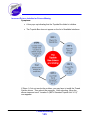
1
Sea Scan® Survey
V2.5.0
Easy-to-use PC-based software for side-scan SONAR
data collection, processing, viewing, and analysis for use
with Sea Scan HDS SONAR Systems
Part Number
SSS-2HDSSVY-0003
This product was designed and developed by a team of engineers at Marine Sonic Technology,
Ltd.
© 2011 Marine Sonic Technology, Ltd., All Rights Reserved.
Marine Sonic Technology, Ltd.
5508 George Washington Memorial Highway
P.O. Box 730, White Marsh, VA 23183-0730
(804) 693-9602
(800) 447-4804
Technical Support
For technical support call (804) 693-9602 or visit our web site at http://www.marinesonic.com.
Copyright
This manual and the hardware/software described in it are copyrighted with all rights reserved. Under
the copyright laws, neither this manual nor the software/hardware may be copied, in whole or in part,
without the written consent of Marine Sonic Technology, Ltd., except in the normal use of the software
or to make backup copies. This exception does not allow copies to be made for others.
Trademarks
Sea Scan® is a registered trademark of Marine Sonic Technology, Ltd.
SHARPS™ is a trademark of Marine Sonic Technology, Ltd.
Other product or brand names are trademarks or registered trademarks of their respective holders.
Contents
Introduction
1
This Manual ................................................................................................................................... 1
The Sections ...................................................................................................................................
of This Manual
1
Understanding
...................................................................................................................................
SONAR
2
Side-Scan Systems
................................................................................................................................... 2
Sea Scan Survey
...................................................................................................................................
Software
5
Overview of the Sea Scan® Survey Software
7
System Requirements
................................................................................................................................... 7
Loading the Software
................................................................................................................................... 7
The Help Files
................................................................................................................................... 8
Buttons and Menus
10
Introduction...................................................................................................................................
to Each Window
10
Caption Bar ..........................................................................................................................................................
Status Bar ..........................................................................................................................................................
Tool Definitions
.........................................................................................................................................................
Waterfall .........................................................................................................................................................
Scroll Speed and Direction
Total Time
.........................................................................................................................................................
SONAR Status
.........................................................................................................................................................
SONAR Information
.........................................................................................................................................................
GPS Status
.........................................................................................................................................................
Work Area ..........................................................................................................................................................
Main Menu Bar
..........................................................................................................................................................
File
.........................................................................................................................................................
New
.........................................................................................................................................................
Open
.........................................................................................................................................................
Continue .........................................................................................................................................................
Survey
Most Recently
.........................................................................................................................................................
Used Survey/Files List
Exit
.........................................................................................................................................................
View
..........................................................................................................................................................
Menu Bar.........................................................................................................................................................
Status Bar.........................................................................................................................................................
Status Window
.........................................................................................................................................................
SONAR Control
.........................................................................................................................................................
Window
Image Adjustment
.........................................................................................................................................................
Window
Marker Management
.........................................................................................................................................................
Window
Navigation
.........................................................................................................................................................
Plotter Window
A-Mode Window
.........................................................................................................................................................
Signal Statistics
.........................................................................................................................................................
Window
Waterfall .........................................................................................................................................................
Toolbar
Contents
11
11
12
12
12
12
12
12
13
13
13
14
15
16
16
16
16
17
17
18
18
19
19
20
20
21
21
Tools
..........................................................................................................................................................
Settings .........................................................................................................................................................
Waterfall .........................................................................................................................................................
Capture
Ping Capture
.........................................................................................................................................................
Start a New
.........................................................................................................................................................
File (Ins)
Chart Management
.........................................................................................................................................................
Unlicensed/Free.........................................................................................................................................
(NOAA USA Coast Line) S-57 charts
S-57 Charts for Other
.........................................................................................................................................
Areas Outside of the USA
Deleting Charts .........................................................................................................................................
Additional Charts.........................................................................................................................................
Survey Report
.........................................................................................................................................................
SDS-to-XTF
.........................................................................................................................................................
Converter
Help
..........................................................................................................................................................
Help Topics
.........................................................................................................................................................
About Sea.........................................................................................................................................................
Scan Survey
21
21
22
23
23
23
24
28
34
34
35
36
37
37
38
Docking Semantics
................................................................................................................................... 39
Docking Markers
..........................................................................................................................................................
Tab Interface ..........................................................................................................................................................
Auto Hide
..........................................................................................................................................................
40
41
42
Docking Window
...................................................................................................................................
Features
42
Navigation Plotter
..........................................................................................................................................................
Window
Toolbar
..........................................................................................................................................................
SONAR Control
..........................................................................................................................................................
Window
SONAR Power
.........................................................................................................................................................
Transducers
.........................................................................................................................................................
Range .........................................................................................................................................................
Range Delay
.........................................................................................................................................................
Speed Over
.........................................................................................................................................................
Ground (SOG)
Status Window
..........................................................................................................................................................
Marker Management
..........................................................................................................................................................
Window
Signal Statistics
..........................................................................................................................................................
Window
A-Mode Window
..........................................................................................................................................................
Image Adjustment
..........................................................................................................................................................
Window
Histogram.........................................................................................................................................................
Control
Reset Button .........................................................................................................................................
Transfer Left Button
.........................................................................................................................................
Transfer Right Button
.........................................................................................................................................
Locked Button .........................................................................................................................................
Manual Gain .........................................................................................................................................
Manual Gain Sliders
.........................................................................................................................................
Apply-To-All-Data
.........................................................................................................................................
Button
SONAR Waterfall
.........................................................................................................................................................
Display
43
47
48
49
50
51
51
52
52
54
58
59
59
60
61
61
61
61
61
62
62
62
SONAR Waterfall
...................................................................................................................................
Toolbar
64
Elapsed Time..........................................................................................................................................................
Indicator
Rewind Button
..........................................................................................................................................................
Stop Button ..........................................................................................................................................................
Fast Forward ..........................................................................................................................................................
Button
Home Button ..........................................................................................................................................................
Jump-To Button
..........................................................................................................................................................
Contents
65
66
66
66
66
66
Speed-Over-Ground
..........................................................................................................................................................
Correction
Waterfall Boat..........................................................................................................................................................
Icon
Measurement..........................................................................................................................................................
Tools
Length Tool
.........................................................................................................................................................
Area Tool.........................................................................................................................................................
Height Tool
.........................................................................................................................................................
Palette Tool
.........................................................................................................................................................
Zoom Tool
.........................................................................................................................................................
Last Measurement
.........................................................................................................................................................
Readout
Channel Mode
.........................................................................................................................................................
67
67
67
67
68
69
70
70
71
71
Settings Window
................................................................................................................................... 72
Waterfall
..........................................................................................................................................................
Zoom Settings
.........................................................................................................................................................
Image Adjustments
.........................................................................................................................................................
View Raw Data .........................................................................................................................................
Manual TVG
.........................................................................................................................................
Manual TVG Sliders
.........................................................................................................................................
Color Palette .........................................................................................................................................
Features .........................................................................................................................................................
SONAR .........................................................................................................................................................
Resolution
.........................................................................................................................................
Across Track ...................................................................................................................................
Along Track ...................................................................................................................................
Interface
.........................................................................................................................................
Navigation
.........................................................................................................................................................
and Fathometer
NMEA (National.........................................................................................................................................
Marine Electronics Association) Data Input
Plotter
.........................................................................................................................................
Units
.........................................................................................................................................................
Survey Settings
.........................................................................................................................................................
Marker Labels
.........................................................................................................................................................
Application
.........................................................................................................................................................
Quick-Start Procedures
73
73
74
75
76
77
78
79
80
80
80
81
81
83
83
86
89
90
91
92
94
Frequently Asked Questions
109
In-Depth Discussion
114
Overview ................................................................................................................................... 114
Search Methodology
................................................................................................................................... 115
Site/Feature ..........................................................................................................................................................
Location
Towfish Frequency
..........................................................................................................................................................
and Range
Startup and ..........................................................................................................................................................
Operation
Site/Feature ..........................................................................................................................................................
Identification
Safety
..........................................................................................................................................................
115
116
116
117
118
User Settings
................................................................................................................................... 118
SONAR Interface
..........................................................................................................................................................
SONAR Display
..........................................................................................................................................................
Color
..........................................................................................................................................................
Contents
119
119
119
Selecting.........................................................................................................................................................
a Color
Inverting.........................................................................................................................................................
a Color
Moving through
..........................................................................................................................................................
the Data
Scrolling.........................................................................................................................................................
Home State
.........................................................................................................................................................
Jump-To.........................................................................................................................................................
Tool
Channel
..........................................................................................................................................................
Measurements
..........................................................................................................................................................
Height .........................................................................................................................................................
Length .........................................................................................................................................................
Area
.........................................................................................................................................................
Units
..........................................................................................................................................................
120
120
120
120
120
121
121
121
121
122
123
124
SONAR Control
................................................................................................................................... 125
Power
..........................................................................................................................................................
Range
..........................................................................................................................................................
Range Delay..........................................................................................................................................................
Frequency ..........................................................................................................................................................
Speed Control
..........................................................................................................................................................
125
126
126
127
127
Image Adjustment
................................................................................................................................... 128
Gain
..........................................................................................................................................................
128
Navigation ...................................................................................................................................
and Fathometer Interface
130
Navigation ...................................................................................................................................
Plotter
132
Layout
..........................................................................................................................................................
Boundary Conditions
..........................................................................................................................................................
Zoom .........................................................................................................................................................
Center/Pan
.........................................................................................................................................................
Automatic
.........................................................................................................................................................
Center
Length .........................................................................................................................................................
Map-Bearing
.........................................................................................................................................................
Line
Clear Navigation
.........................................................................................................................................................
133
133
133
134
134
134
134
134
Markers and
...................................................................................................................................
Waypoints
135
Markers
..........................................................................................................................................................
Waypoints ..........................................................................................................................................................
Adding Markers
.........................................................................................................................................................
and Waypoints
Editing Markers
.........................................................................................................................................................
and Waypoints
Managing
.........................................................................................................................................................
Markers and Waypoints
Deleting.........................................................................................................................................................
Markers and Waypoints
135
135
135
136
136
137
Managing a...................................................................................................................................
Survey
137
About Surveys
..........................................................................................................................................................
Survey Folder
..........................................................................................................................................................
Organization
Making a New
..........................................................................................................................................................
Survey
Adding New ..........................................................................................................................................................
Data to a Survey
Opening a Survey
..........................................................................................................................................................
for Review
Exporting a Survey
..........................................................................................................................................................
Troubleshooting
138
138
138
138
138
139
141
Software Issues
................................................................................................................................... 141
Contents
Software Manager
..........................................................................................................................................................
Shows "Failed to Synchronize the Data Stream"
Software Manager
..........................................................................................................................................................
Shows "Failed to Connect"
SONAR Not Connected
..........................................................................................................................................................
Interface Does
..........................................................................................................................................................
Not Start or the Wrong Interface Starts
Incorrect Drivers
..........................................................................................................................................................
Installed or Drivers Missing
No GPS Data..........................................................................................................................................................
Is Being Received
141
142
143
144
145
146
Hardware Issues
................................................................................................................................... 148
The Simple Topside
..........................................................................................................................................................
Unit Does Not Power Up
The Towfish..........................................................................................................................................................
Does Not Communicate
Revisions
148
149
150
Revision History
................................................................................................................................... 150
Glossary of Acronyms and Terms
151
Contact and Support Information
158
Index
159
Contents
Introduction
This Manual
Welcome to Sea Scan® Survey software manual, Version 2.4.0. This manual
introduces new users to the 2010 version of the Sea Scan® Survey SONAR 151
collection and processing program. Sea Scan® Survey, Version 2.4.0, is part of the
Marine Sonic Technology, Ltd. side-scan SONAR system, Sea Scan® High-Definition
SONAR (HDS 151 ). The user is assumed to have little or no experience with side-scan
SONAR systems and software.
The material in this manual is organized into discrete sections for easy acquisition of the
basics about how to navigate through the most common screens or collect data quickly.
There is even a chapter devoted to Frequently Asked Questions 109 (FAQ 151 ). Those
wishing to go beyond the basics will find
in-depth explanations 114 in the latter part of the manual.
A reference guide to abbreviations, acronyms, and symbols commonly used in SONAR
discussions is in the Glossary 151 . As an added feature, look for italicized words in the
text, as these terms are defined in the Glossary.
Instructions on assembly, maintenance, or repair of Sea Scan® Survey side-scan
SONAR 151 systems can be found in separate Marine Sonic Technology, Ltd.
maintenance and operation manuals.
The Sections of This Manual
This manual is organized into the following sections:
Introduction to Sea Scan® Survey 1
Overview of the Sea Scan® Survey Software
The Buttons and Menus 10
Quick-Start Procedures 94
Frequently Asked Questions 109
In-Depth Discussion 114
Troubleshooting 141
Revision History 150
Glossary of Acronyms and Terms 151
Index
Introduction
1
7
Tip
Italicized words in text are defined in the Glossary.
Understanding SONAR
SONAR is a coined word derived from the phrase, SOund Navigation And R
anging. SONAR 151 generally refers to the system that uses acoustic (sound)
energy transmitted through water. At the heart of that system is the transducer 151
, the device that converts electrical energy to sound and vice versa and is
responsible for generating the sound pulse. That same transducer is also used to
receive the echo that “bounces” off objects encountered along its path. Thus,
SONAR is a system that determines the position of unseen underwater objects by
transmitting sound waves and measuring the time it takes for their echo to return
after hitting the object.
Side-Scan Systems
Because of their innate flexibility, side-scan systems such as Sea Scan® HDS can
be used in many applications, some of which involve highly sophisticated
remotely operated vehicles (ROVs 151 ) or autonomous underwater vehicles (AUVs
151 ). But the most common side-scan systems are towed behind a surface vessel
and comprise three elements:
1. the control unit containing the software
2. the towfish 151 with transducers mounted on each side
3.
the cable that connects the towfish to the surface vessel that follows a
prescribed track or course through the water
The images they create can be used for geologic studies, locating sunken
objects, or ensuring the waterway is clear and safe for shipping.
The transducer assembly is towed on a steady course and at a constant depth
through the water. As it is towed, the assembly emits sound pulses at precise
and regulated intervals. The system receives the returning echoes from the water
column 151 and seafloor shortly after emitting a pulse. This continues for a short
period until the next pulse is transmitted, thus beginning a new cycle. The
returning echoes from one pulse are displayed on the SONAR window as one
single line, with dark and light portions of that line representing strong or weak
echoes relative to time. The stronger the SONAR’s returning signal, the brighter
the mark that appears on the SONAR window or waterfall 151 . The resulting
Introduction
2
accumulated lines then form a coherent picture of the seafloor.
Each of the two transducers provides information unique to their particular side of
the towfish. In between them is the boat’s track immediately below the towfish.
That center display or water column loosely relates to the boat’s track. It
communicates details about objects encountered before the first bottom return
and can include things such as surface returns, debris, fish, and objects
protruding from the sea floor.
The quality of the SONAR data will depend on operator management and the
data-gathering process, which involves vessel course, tow speed, towfish altitude
above the bottom, sea conditions, and range settings. For example, a higher
range setting yields a larger data sample with more of the seafloor displayed; but
the data will not have as high a resolution.
Figure 1 provides an indication of the objects a towfish can reveal on a sea floor.
Figures 2–4 typify actual objects observed with the Sea Scan® Survey system.
· Figure 1. Side-scan operation reveals features or objects on the sea floor
(figure courtesy of the USGS)
Introduction
3
·
Figure 2. 600-kHz image of a 10-speed bicycle (identified with Sea Scan® PC software)
• Figure 3.
Two upside-down submerged cars (identified with Sea Scan® PC software)
Introduction
4
· Figure 4. Navy PB4Y-2 Privateer Aircraft (identified with
Sea Scan® PC software)
Sea Scan Survey Software
Sea Scan® Survey represents the latest in sophisticated software development. It
is part of the Sea Scan® HDS system developed by Marine Sonic Technology,
Ltd. It is easy to use and is compatible with Microsoft Windows™ operating
systems. In fact, the software has been designed so that the Sea Scan® Survey
windows and buttons have the same appearance and practical use as those in
typical Microsoft programs.
Sea Scan® Survey is specialized for use with Marine Sonic Technology, Ltd.
high-resolution side-scan systems. This software package is distinctive for use in
search-and-recovery missions. Sea Scan® Survey users include local police
forces, the U.S. Coast Guard, the U.S. Navy, the Department of Homeland
Security, and the U.S. military.
Figure 5 graphically shows the components that make up a Sea Scan® Survey
system.
Introduction
5
· Figure 5. The basic components of a Sea Scan® Survey system
The operator can view wide tracts of the seafloor because the transducers ping
along the swath width and the software records the strength of the echoes from
the sea bottom. The towfish is towed just above the seafloor bottom. The
transducers periodically emit narrowly focused beams of sound perpendicular to
the path of motion. The sound pulses pass through the water but are reflected
from the seafloor and objects, such as wreck sites that sit on the seafloor. The
computer records the echo signal strengths as they return and draws the entire
SONAR record line on the screen. Thus, an image is built, line by line, as the
SONAR record line from each ping returns and is drawn on the screen.
Introduction
6
Overview of the Sea Scan® Survey
Software
System Requirements
Sea Scan Survey requires the following capabilities.
Intel-based Windows© Operating
System
XP, Vista, Windows 7
Hard drive space
100 MB 151 + data storage
Available RAM 151
512 MB minimum;
1 GB 151 recommended
Processor Speed
1.6 GHz 151 or better
Other Features
Ethernet or USB 151 2.0 port
Screen Resolution
1024 x 768 minimum or higher
Loading the Software
Tip
All instructions in this manual assume a right-handed user and left clicks
unless otherwise indicated.
The Sea Scan® Survey application is as easy to load onto your personal computer
(PC 151 ) or laptop as any Windows-based program.
Tip
The symbols < > surrounding a word in bold throughout this document
indicate an action you can take by clicking on that word or symbol
1. Insert the Sea Scan Survey compact disk (CD 151 ) into the CD drawer.
2. After the CD has loaded, go to <My Computer>.
3. Move your mouse pointer to the drive containing the CD.
4. Double click the left mouse button to show the contents of the CD.
Overview of the Sea Scan® Survey Software
7
5. Place the mouse pointer over the installation program icon
double click the left mouse button. The Setup Wizard will open.
and
6. Click <Next> with the left mouse button.
7. A window will open regarding the License Agreement. Read the
agreement carefully. If you accept its terms, move your mouse pointer
to the button next to the statement, <I agree> at the bottom left of the
open window. Click on that button.
8. A window will open that permits you to install the components you want
and to deselect those you don’t. Simply click <Next> to accept the
components that are selected.
9. A window will open in which you may choose an alternate location for
installing the program. Allow Sea Scan Survey to place the files where
indicated or follow the instructions on the screen to designate a
different location. Then click <Install> at the button at the bottom of
the box.
10.A window will open asking you to wait for the program to be installed. It
requires no action on your part.
11.Click <OK> to exit the Wizard when a box opens indicating that the
FTDI CDI Drivers have been installed.
12.Click <Finish> when the final setup screen opens.
The Sea Scan Survey icon
will now be available on your desktop as a
shortcut for opening the program. Double click with the left mouse button on the
icon to start the program.
The Help Files
The Sea Scan Survey side-scan SONAR software makes it easy for novices to
learn how to manipulate the screens and begin to collect data almost
immediately. To quicken the learning process, Marine Sonic Technology, Ltd.
has developed a Help 37 file that describes every function and key. Thus, a fairly
comprehensive “virtual” software manual for Sea Scan Survey resides on your
computer as soon as you successfully load the software.
Overview of the Sea Scan® Survey Software
8
In addition, the buttons identify themselves for you, as shown in the figure that
follows.
Overview of the Sea Scan® Survey Software
9
Buttons and Menus
Introduction to Each Window
Before you begin to run the Sea Scan® Survey software itself, get to know the
features that are available to you. This chapter introduces you to all the basic
buttons, menus, and screens that you will use as you collect and analyze SONAR
data. In the next chapter, Quick Start: Procedures 94 , you will learn how to run the
data collection application and gather data during a SONAR run.
Start Sea Scan Survey by double clicking on the Sea Scan Survey icon if it resides
on your desktop. Another approach is to click on <Start> at the bottom left of your
computer screen. Then, click on <All Programs>. Select <Marine Sonic
Technology, Ltd> from among the list of programs on your computer. You will see
the name listed to the right. Click on the name, <Sea Scan Survey>.
The software will start and you will see the introductory window, which presents the
company logo, version number, as well as contact information.
Buttons and Menus
10
After the application has fully loaded, the workspace window will open. The
remainder of this chapter presents an overview of each item you will see there,
along with an explanation about the screens, buttons, and menus.
Caption Bar
The caption bar at the top left of the window displays the name of the software
and the current open survey or data file.
If the survey fails to open for some reason, a message will display in the caption
bar in place of the name of the survey. At the top right of this caption bar, you will
see the usual Minimize <–>, Expand <2>, and Close <x> Windows-based
control buttons.
At the left of the caption bar is the system menu. Access this menu by clicking on
the Marine Sonic Technology, Ltd. dolphin in the far left top corner. You will now
see a pull-down menu that offers the usual Windows-based choices.
Status Bar
The Status bar runs along the bottom of the workspace window 13 and presents
information at the far left about each button in the waterfall toolbar and in the
main menu dropdown lists (shown here defining the Color Palette 70 button), the
range and transducer settings, the Global Positioning System (GPS 151 ) status
(quality of the incoming signal), the waterfall speed and scroll direction (here
stopped), total amount of time in a survey or data file, and the SONAR status.
Buttons and Menus
11
Tool Definitions
The leftmost portion of the Status bar at the bottom defines any waterfall tool 21 you
point to with the mouse pointer. It also gives a brief explanation of any item listed in
the main menu dropdown lists (here, explaining the Jump To button).
Waterfall Scroll Speed and Direction
The Status bar shows how fast the waterfall is scrolling (1x to 30x) and in what
direction; otherwise, it will indicate that the waterfall is stopped. The waterfall
automatically scrolls at 1x forward when a file is opened.
The waterfall speed shown in the Status bar is relative, not absolute.
Total Time
The Status bar shows the total amount of survey or data time in the buffers in
hours:minutes:seconds (from left to right).
SONAR Status
The SONAR Status bar portion of the Status bar is at the right end. It will have a
green background and also indicate in words that the SONAR is connected. The
background will be red and the words will indicate that the SONAR is off when it is
not connected.
SONAR Information
The SONAR Information bar portion presents the range 151 and frequency of the
transducers.
GPS Status
The GPS Status bar portion shows the estimated accuracy. If under 50 feet
accuracy, the background turns green, above 50 feet, the background turns
; if the background turns red, the GPS data is insufficient, invalid, or lost.
Buttons and Menus
12
Work Area
The work area is your palette for acquiring, evaluating, and marking incoming towfish
data. As in the sample below, the work area also shows the echo information that
creates a picture of the seafloor.
Main Menu Bar
File
As is standard with any Windows-based program, the File pull-down menu
allows you to create a <New> file, <Open> an existing one, <Continue
Survey>, or <Exit>.
Tip
Use the <Alt> button to access the menu. Then the corresponding
underlined letter can be pressed on the keyboard.
Buttons and Menus
13
New
Opens the Begin a New Survey Wizard. The Wizard asks for a survey folder
(where you want the information stored), name for the file, a brief description (so
you can discriminate in the future between multiple survey files), and the
filename prefix. Sea Scan Survey requires this detail because you are creating a
“filing cabinet” for all the data files, the survey file, marker snapshots, and the
waypoint data that you collect during a survey.
The settings in the window are the default entries that the software has
automatically assigned. To change the default survey location, click on the <
Browse> button (see above figure). To change the survey name and/or data file
prefix or to add a description, replace the information in the white boxes with
your own designations.
Buttons and Menus
14
An alternative to that approach is to click on the <Tools> button.
pull-down menu, select <Start a New Survey>.
At the
The window will open and the screen, "Begin a New Survey," will appear.
Open
Two choices are immediately presented to you when you click on the Open
command: you can choose to open a Survey or a File.
Opening a Survey
When you open a Survey, you are actually retrieving a filing cabinet full of files
that include all the marker 151 s and waypoint 151 s you inserted during data
collection. These files are set up in such a way that the software can move
seamlessly through the large amounts of data it has collected. Thus, all the data
in that Survey filing cabinet can be accessed without your having to look through
individual files.
Tip
When you wish to view a marker or waypoint that you inserted during a
search, the software automatically sifts through all the files it has stored
in that Survey "filing cabinet." The software then shows that location in
the Navigation Plotter window.
When you open a Survey, the software automatically starts buffering 151 (loading)
the first file in that survey into memory. Survey files end in the extension, .xvy 151
. You cannot add files to the opened survey.
Tip
The only way to append new files to an existing survey is to select
Continue Survey at the File dropdown list.
Buttons and Menus
15
Opening a File
When you open a File, which is one file that contains data only, the software
automatically starts loading the file. The SONAR Data Stream files end in the
extension, .sds 151 . In this mode, you cannot create markers or waypoints.
However, you can select and open multiple files. As you select the files to open,
the software creates a temporary survey; this temporary survey will be deleted
when you close the files or end the program.
Continue Survey
When you open an existing Survey file to continue adding data to it, the software
will create a new data file and will be ready to record the new information. Then,
as the new information is recorded, it will be appended to the end of the
pre-existing data in that opened survey file.
Tip
You cannot accidentally overwrite a survey. A query box always pops up
and asks for confirmation before overwriting.
Most Recently Used Survey/Files List
This listing appears beneath the <Continue Survey> option on the <File>
pull-down menu. It shows your most recently opened or created surveys. Left
click on one of these in the list and the software will immediately open the survey
for you.
Exit
This option immediately exits the program.
Tip
Sea Scan Survey constantly saves data to its files, so there is no need to
click on <Save> before exiting the program.
View
The View pull-down menu shows the windows that you can open as you work.
These windows can then be docked and/or hidden when not needed (see also
Docking Semantics 39 ). Simply click on the window you wish to open. A check mark
will remain there as long as the checked window is open.
Buttons and Menus
16
Menu Bar
Click this option in the <View> pull-down menu to show or hide the Main Menu bar.
The default placement of the Menu bar is normally at the top of the Sea Scan
Survey window.
Status Bar
Click this option in the <View> pull-down menu to show or hide the Status bar. The
Status bar is in a fixed location at the bottom of the Sea Scan Survey window and
cannot be moved.
Buttons and Menus
17
Status Window
Click this option in the <View> pull-down menu to show or hide the Status window.
The default placement of the Status window is up to you. (See the discussion on
Docking Semantics 39 for how to adjust window placement.)
SONAR Control Window
Click this option in the <View> pull-down menu to show or hide the SONAR Control
Window. The default placement of the SONAR Control Window is up to you.
(See the discussion on Docking 39 Semantics 39 for how to adjust window
placement.)
Buttons and Menus
18
Image Adjustment Window
Click this option in the <View> pull-down menu to show or hide the Image
Adjustment Window. The default placement of the Image Adjustment Window is
up to you. (See the discussion on Docking Semantics 39 for how to adjust window
placement.)
Marker Management Window
Click this option in the <View> pull-down menu to show or hide the Marker
Management Window. The default placement of the Marker Management
Window is up to you. (See the discussion on Docking Semantics 39 for how to
adjust window placement.)
Buttons and Menus
19
Navigation Plotter Window
Click this option in the <View> pull-down menu to show or hide the Navigation
Plotter Window. The default placement of the Navigation Plotter Window is up to
you. (See the discussion on Docking Semantics 39 for how to adjust window
placement.)
A-Mode Window
Click this option in the <View> pull-down menu to show or hide the A-Mode
Window. The default placement of the A-Mode Window is up to you. (See the
discussion on Docking Semantics 39 for how to adjust window placement.)
Buttons and Menus
20
Signal Statistics Window
Click this option in the <View> pull-down menu to show or hide the Signal
Statistics 151 Window. The default placement of the Signal Statistics Window is
up to you. (See the discussion on Docking Semantics 39 for how to adjust window
placement.)
Waterfall Toolbar
Click this option in the <View> pull-down menu to show or hide the Waterfall toolbar.
Tools
The Tools pull-down menu provides access to the settings you can adjust when
starting a search or any time during the data capture process. Simply click the option
you wish to open.
Settings
Click Settings and a window opens. This window provides you access to the
settings you can adjust as you collect SONAR data. At each of the seven
categories of Waterfall, SONAR, Navigation & Fathometer, Units, Survey
Buttons and Menus
21
Settings, Marker Labels, or Application, you will see a <–> (indicating that all
the pages under that category are open, as shown below for the Waterfall
folder); or you will see a <+>, indicating that more pages are available under that
category, as shown in the SONAR and Navigation & Fathometer pages. Click
on the <+> to open that category. Then, click on any of those headings in the list
to view the relevant page.
Waterfall Capture
Click on Tools, then Waterfall Capture and the Save Screen Capture window
opens. At this window, you can take an instant snapshot of the current screen and
save the image as a bitmap (bmp 151 ) image file. You then choose the file name and
the location where you wish to save the image file. Click on <Save> to save the
image file. If you do not wish to save the image file, click on the <Cancel> button.
Tip
You can press the F-10 key at any time to pull up this same screen.
Buttons and Menus
22
Ping Capture
Click on Tools, then Ping Capture, and the Save Ping Capture window opens.
If you would like to save the raw data from a ping 151 that you are pointing to in
the waterfall display window, you can do so by saving this ping capture as a
comma-separated value (csv 151 ) text file.
Tip
You can press the F-11 key at any time to pull up this same screen.
Start a New File (Ins)
This shortcut option allows you to start a new file from the <Tools> pull-down menu.
This becomes convenient when doing surveys and you want to ensure that a survey line
is in one file.
Chart Management
Click on Tools, then select this item to run the Chart Management software for
the Electronic Navigation Charts.
Buttons and Menus
23
Sea Scan Survey V2.4.0 contains a new version of the S-57 Electronic
Navigation Chart (ENC) 151 charting code. This new version is incompatible with
any previously installed S-57 chart databases in Sea Scan Survey. Therefore, if
you have V2.3.0 or earlier, uninstall Sea Scan Survey and the USA Charts. A
new USA coastline installer now addresses this issue.
Sea Scan Survey uses two separate charting folders:
1. USENC for the unlicensed/free S-57 charts
2. LSENC folder for the licensed/purchased S-57 ENC charts.
The details on chart management for each chart type are listed below.
Unlicensed/Free (NOAA USA Coast Line) S-57 charts
To use the unlicensed/free S-57 charts in Sea Scan Survey, you must install the “
Install Sea Scan Survey USA Charts.exe” installation package. This will create a
base chart database, add the World Vector Shoreline (WVS 151 ) data, and
optionally install precompiled National Oceanic and Atmospheric Administration (
NOAA) 151 USA coastline charts. If you install the NOAA USA coastline charts
using the installer and do not need to update, remove, or change the charts, then
you do not have to do anything else.
To update or remove charts from the database, Sea Scan Survey uses the
USENC folder for your chart database. To select charts for use with Sea Scan
Survey, visit NOAA’s ENC chart downloader web site:
http://www.charts.noaa.gov/ENCs/ENCs.shtml.
Once there, choose the particular set of charts you would like to use.
Tip
Marine Sonic Technology Ltd. offers the NOAA unlicensed/free
charts in the complete installation package and updates are
issued at least once a year.
Buttons and Menus
24
If you do not require the full set of charts, then choose a set organized by Coast
Guard district, by state, or by region. By installing only the charts you need, you
will reduce the amount of disk space needed and possibly speed up the
chart-drawing process in Sea Scan Survey.
No license is required for these, so the only files you need are the charts files
themselves.
Tip
When you download the charts keep them as .zip files. Do not
extract them.
To install charts into the Sea Scan Survey charting database,
1. Start Sea Scan Survey and choose Chart Management from the Tools
menu. This will open the Cell Manager program. The cell manager
starts by asking the location of the chart database. This is typically
C:\Program Files\Marine Sonic Technology, Ltd\Sea Scan
Survey\USENC\ for the unlicensed/free charts. You can browse to the
folder using the
button that is at the side.
2. When you have entered the correct folder, the window will say “Valid chart
folder,” as shown in the above figure. Click the <OK> button, and then
click the <Install Exchange Set> button. This will open the ENC Chart
Management Window.
Buttons and Menus
25
3. Choose the <Path to the compressed Exchange Set> button.
Browse to
the location where your charts are stored using the
button (see
above). This is the location where you downloaded the charts. You can
browse to the location by using the
button. If it is a valid zip file
containing a chart set, the name of the chart set will appear below the
path. If it is not valid, the program will say “Not a zip archive containing an
Exchange Set” below the path. Click the <Next> button.
Buttons and Menus
26
4. Choose the installation options. It is generally a good idea to check all of
them: Pause on Error and Delete old withdrawn cells (to prevent buildup
of unused data). Click the <Next> button.
Buttons and Menus
27
5. The application will now begin to install the chart sets (this may take
several minutes).
6. Close the application when it has completed installing the chart sets.
S-57 Charts for Other Areas Outside of the USA
Before you use the licensed S-57 charts in Sea Scan Survey, you must install the
“Install Sea Scan Survey Licensed Charts.exe” installation package. This will
create a base chart database, add the World Vector Shoreline data, and install
USB drivers for the USB security dongle 151 . When installing or using the
licensed charts, the USB security dongle must be plugged in to the
computer.
Buttons and Menus
28
Sea Scan Survey uses the LSENC folder for your chart database. However,
before you can purchase charts for use with Sea Scan Survey, you must choose
a chart provider. Currently, there are two major chart providers to choose from:
the United Kingdom Hydrographic Office (http://www.ukho.gov.uk/) and Primar
(http://www.primar.no/).
When you have chosen the chart provider you would like to use, you must locate
a distributor (in order to purchase the charts). Both chart providers have a link
on their web pages to their distributors.
Tip
We suggest you narrow the distributors down geographically and
then choose the best one based on their willingness to work with
you to purchase charts.
After finding the distributor, pick out the S-57 ENC charts you would like to
purchase. This is generally accomplished by using a chart catalog.
Warning
SOME DISTRIBUTORS DO NOT SELL THE S-57/ENC
CHARTS, SO PAY CLOSE ATTENTION TO THE
DISTRIBUTOR LISTS, AS THE LISTS SHOULD INDICATE
WHAT FORMATS THE CHART DISTRIBUTOR CARRIES.
Buttons and Menus
29
The chart catalog is usually a piece of software that allows you to choose charts
graphically for the area you are interested in. Both chart-provider companies
offer free downloading of their chart catalogs. When you have downloaded and
installed a company's chart catalog, you use that chart catalog to select the
charts you want and place them in the Chart Basket. When you have completed
filling your basket, you then must save the basket to a file.
ENC charts are typically sold as on a subscription basis. The length of the
subscription determines how long you have access to chart updates. Typically,
1-month, 3-month, and 12-month subscriptions are available. Generally, the
shorter the subscription, the cheaper the charts will be. At the end of the
subscription interval, you will still be able to use the charts; however, you will no
longer receive updates.
Tip
Make sure you check with your chart distributor for details about the
subscription service and updates.
To order the charts in your basket, you typically send the Chart Basket file to the
distributor by e-mail along with your User Permit that is associated with your
licensing dongle. The User Permit is a 28-character code made up of letters and
numbers.
Tip
You should have received a User Permit with the Sea Scan HDS
system; however, if you need to retrieve it, you can use Sea Scan
Survey to get it. Do this by opening the Plotter Settings. Make sure
the “Premium S-57” chart is selected. If the premium charts were
not enabled before opening the plotter settings, click the Apply
button upon selecting the premium charts, then click on the
Configure button. Failing to do so will result in the User Permit not
being found.
Below are the windows described in the above Tip.
Buttons and Menus
30
When you have sent your Chart Basket and user permit to the chart distributor
(and paid them), they will send you a permit file and instructions on retrieving the
charts. They may also send you the charts on CDs or DVDs. With the permit
file and the charts, you can now install them into the Sea Scan Survey charting
database.
Warning
YOU MUST USE THE FOLLOWING APPROACH USING
SEA SCAN SURVEY TO ACCESS AND DOWNLOAD THE
LICENSED FROM THE CDs/DVDs THE CHART
DISTRIBUTOR SENDS. NO PC-BASED INSTALLER WILL
SUPPORT THIS PROCESS.
To install the charts into the Sea Scan Survey charting database,
1. Start Sea Scan Survey and choose Chart Management from the Tools
menu. This will open the Cell Manager program. The cell manager starts
by asking the location of the chart database (typically C:\Program
Buttons and Menus
31
Files\Marine Sonic Technology, Ltd\Sea Scan Survey\LSENC\) for the
licensed charts. You can browse to the folder using the
button.
2. After you have entered the correct folder, you will see “Valid chart folder” in
the window. Click <OK>, then click the <Install Exchange Set> button.
This will open the ENC Chart Management Window.
3. Choose the <Path to the root folder of the Exchange Set> button. Browse
to the location where your charts are stored. This is probably your CD/DVD
drive. You can browse to the location by using the
button. If it is a
valid location, the name of the chart set will appear below the path. If it is
not, the program says “Not an exchange set” below the path. Click the
<Next> button.
4. Next, choose the installation options. It is generally a good idea to check
all of them: Pause on Error, Install Permits (required), and Delete old
withdrawn cells (to prevent buildup of unused data). Click the <Next>
button.
5. The last step before the installation process begins is to select the permit
file. This file should be a text file that the chart distributor sent you when
you purchased the charts. It is usually called permit.txt. Click the
button to browse to the location where you stored the permit file. When a
valid permit file is chosen, the application will indicate it by displaying the
Buttons and Menus
32
permit data and version.
6. Click the <Next> button to begin installation of the permits. When the
permits have been installed, click the <Next> button. The application will
now begin to install the chart sets. Close the application when it has
completed installing the chart set or click the <Install Exchange Set> button
again to install another chart set.
Tip
You may need to repeat this process for more than one chart
set. In fact, you may have to perform these actions for each
CD.
Buttons and Menus
33
Now that the exchange set has been installed, it is ready for use in Sea Scan
Survey. If the chart background does not update properly, it may be necessary to
close Sea Scan Survey and reopen it.
Deleting Charts
You may want to delete charts at some point in time. To delete charts,
1. Start by opening the Chart Management application from the Tools menu
in Sea Scan Survey.
2. Choose the unlicensed chart database folder as instructed above. Then,
use the mouse to select the charts you wish to delete.
3. Click the <Delete Cells> button when ready to remove the selected charts.
To select multiple charts, hold down the CTRL or SHIFT key while clicking
on the charts.
Additional Charts
In addition to the S-57 charts, the Unlicensed and Licensed chart installers now
include the WVS (World Vector Shoreline) data. This data fills in where there is
no S-57 ENC data. It is not nearly as detailed as the S-57 charts can; in fact, It
generally is just an outline of the shore.
Buttons and Menus
34
Survey Report
Export a survey and markers as an HTML 151 (Hypertext Markup Language) report
that generates in the report subfolder. It will then open the report in your default web
browser. The report has been specially formatted to facilitate printing.
Please note that using this feature will tie up the Sea Scan Survey application until all
markers and waypoints have been processed. Each marker and waypoint will be
successively highlighted by a green box as the file processes the information to
complete the report, which will be exported to your web browser for viewing. A
sample survey report is shown below. Note the corporate logo in the top left corner.
This logo can be changed to that of your organization (see how to change the logo in
Exporting a Survey 139 , in the In-Depth 114 section).
Buttons and Menus
35
SDS-to-XTF Converter
This menu item runs the dialog window where you can convert SONAR Data Stream
(sds 151 ) data to eXtended Triton Format (xtf 151 ). The xtf file format is used widely for
recording various types of hydrographic survey data, including side-scan SONAR,
shallow seismic and multibeam bathymetry, associated position, and attitude
information. It is the most commonly used format for this type of information
exchange in the hydrographic survey industry.
Buttons and Menus
36
Click the
button at the right for the “File to Convert” to bring up an Open File
window. There you can select an sds file to convert. Click the
button at the
right of the “Output File” to bring up an Open File window to select an xtf file where
you wish to place the converted data.
Click the <Convert This> button to start the conversion. Click the <Close> button to
close the sds-to-xtf converter window.
Help
This menu option will open the Sea Scan Survey Help pull-down menu. There you
can choose to view Help topics or About Sea Scan Survey by clicking on either
topic.
Tip
The Help file is basically a virtual version of this software manual that you
can access at any time you need information.
Help Topics
Click Help to open this virtual user’s manual. As with any Windows-based
program, this help file is indexed and searchable.
Buttons and Menus
37
About Sea Scan Survey
Click About Sea Scan Survey to open the window that shows the current
version number of the software as well as contact information for Marine Sonic
Technology, Ltd. Click on <OK> to close the window.
Buttons and Menus
38
Docking Semantics
The Sea Scan Survey work area can become quite congested if you open multiple
windows as you are collecting data, yet you will need and want access to the various
windows. These can now be managed quite easily with the unique capability to
move or hide windows until you need access because this software contains a
convenient feature that allows you to open windows of information, then “dock” or
store them on the sides of the work area for future reference. Think of these as tabs
on a “file folder” that you close and stack on the sides of your work area, then
re-open when you need them. You can find these under the
<View 16 > pull-down menu. They include the <Status Window 18 >, <SONAR
Control Window 18 >, <Image Adjustment Window 19 >, <Marker Management
Window 19 >, <Navigation Plotter Window 20 >, <A-Mode Window 20 >, and <
Signal Statistics Window 21 >. Simply select the one you want and that window will
open.
To dock the window, click on the thumbtack icon
at the top right of the window.
Click on the tab to open the docked folder; click on the <x> at the top right of the
opened tab to close it.
Buttons and Menus
39
Docking Markers
Docking markers are like compass-style arrows that you can use to orient the windows
you open from the View 16 pull-down menu. When you click by one of the selections,
that window pops up on your work area screen. Press in the caption bar and hold
down on the mouse button; the compass-style arrows will appear.
Press the mouse button and hold it down as you drag the opened window toward one of
the compass-style arrows. When you reach the arrow you want, simply hold your mouse
pointer over that arrow. A dark blue strip in the work area window appears just before
the window docks to show where that window will reside.
Buttons and Menus
40
You have the choice of letting the window “float” anywhere within your workspace area
or attaching it at the top, bottom, left, or right side of the work area. The window will
remain in that location until you minimize, close, or drag it to another location. Further, if
you close, then reopen the window later, it will pop up where you last placed it.
Tip
You can always place your mouse pointer over one of the open windows,
disable the thumbtack icon, and drag that window to a new location.
Tab Interface
When you want several windows available to you but don’t want to clutter the work
area window unnecessarily, a convenient option is to dock multiple windows at the
side of the work area window with just the name of that window showing. Dock them
by using the thumbtack to auto-hide them.
Buttons and Menus
41
Simply click on the window you want open under the View 16 pull-down menu.
When the window opens, drag and center it over the compass arrow at the location
you have chosen.
Auto Hide
After the window is docked where you want it, click at the margin to the side of the
window. Then click on the Auto Hide icon at the top of the window.
When you move your mouse pointer back to the work area window, the window will
automatically close except for the tab heading, which will be visible at the side of your
workspace. You can reopen that window at any time simply by moving your mouse
pointer back to the side of your workspace and pointing at the tab you want.
Before moving a window that has the Auto Hide feature enabled, you must click
again on the Auto Hide icon to disable it. Then you can drag the window to a new
location and re-enable the Auto Hide feature.
Tip
You can always click and drag at the bottom corner of any floating
window to resize it.
Docking Window Features
A wealth of functions and information is available at the various docking windows.
These windows are the ones you will use most frequently.
Buttons and Menus
42
Navigation Plotter Window
The Navigation Plotter 151 Window displays the current location of the surface
vessel. The boat is represented by an icon that is rotated to show the course or
heading (if the heading is available and if the boat icon option has been selected
in the Plotter Settings window).
The SONAR swath is displayed to show the estimated coverage. The swath 151
coverage for the left channel 151 (transducer) is shown with red lines. The swath
coverage for the right channel is shown with green lines. The boat path is
displayed with a black line (_______). The Plotter will show the boat's location
(including the direction the bow is pointing) even when the SONAR is off;
however, the Plotter will not draw a swath when the SONAR is off or if that option
has been de-selected. Some data is necessary for the Plotter to show a track;
that data may be simply a rub check or by having the SONAR on for a second.
The Navigation Plotter Window displays the scale in user-defined units in the
upper corner. The Plotter window also displays the actual L/L 151 grid lines and
Buttons and Menus
43
labels. Note the red bull's eye just to the stern of the vessel; that bull's eye
denotes a marker.
The Navigation Plotter has two valuable default functions, Center/Pan and
Marker/Waypoint Information. These functions are available when no Plotter
tool is activated.
Center/Pan: Place your mouse pointer at a location you select in the
Plotter window, then double click with the left button. The Plotter will
center on that location.
Marker/Waypoint Information: A single left click in the Plotter window
selects the closest marker or waypoint. Click the mouse pointer on
a marker or waypoint dot to see in the Marker Management
Window the L/L, classification (whether marker or waypoint), and a
preview image if the target is a marker. When you click on the
marker or waypoint, a bull's eye will appear.
Buttons and Menus
44
Tip
The color of the marker bull's eye correlates to the priority you
have attached to that marker (high, medium, etc.). Waypoints
always have a green bull's eye.
The information will be highlighted in blue in the Marker Management Window
54 .
Also, the corresponding marker or waypoint dot that you selected will
become
on the Plotter.
Tip
No Plotter tool can be activated if you want to use either the Center/Pan
or Marker/Waypoint information functions.
Right click on the Navigation Plotter Window to reveal a pop-up menu with the
following options:
Plotter Window Settings
Auto Scale
Auto Center
Create Waypoint
Delete Marker or Waypoint
Edit Waypoint
At this pop-up window, you can access plotter settings, adjust the plotter window
itself, or create or edit waypoints. The approach for waypoints is very convenient
and easy:
1. If you right click randomly in the plotter window, the pop-up window opens
with the <Create Waypoint> option available, but the other waypoint
options gray, thus not accessible.
Buttons and Menus
45
2. If you right click on a waypoint, then it displays the <Edit Waypoint>
option.
3. If you then select either the <Create Waypoint> or <Edit Waypoint>
option, a dialog box opens that allows you to manually enter L/L
information and any description you would like to add.
The Navigation Plotter Window displays all the markers and waypoints within
its view area in relation to the actual SONAR data, giving a real-time view of the
operation. It also shows vector-encoded digital geo-referenced charts 86 in the
background for real-time orientation if you select that option.
Buttons and Menus
46
Tip
The charts on the plotter may slow computer operations; thus you may
wish to de-select that option by changing the Navigation Plotter settings
when the charts aren't needed.
Toolbar
The Toolbar contains the following tools:
Length
: Depress this tool, click once at the starting point on the Plotter, then
click again at the end to draw a line; the software will calculate the length for
you and show it at the right side of the toolbar. That measurement will remain
there until you replace it with another measurement. Click the Escape <Esc>
key to deactivate this tool.
Waypoint
: Depress this tool then click twice in the Plotter window where you
want to place a waypoint. The location and any details you add will be listed
in the Marker Management Window 54 and a dot will be placed at that
location in the Plotter window. Click the Escape <Esc> key to deactivate this
tool.
Map-Bearing Line
: Click on this tool to enable a set of lines that extend from
the bow of the boat across the chart showing the projected direction and
swath (very helpful when performing a search with overlapping lanes). This
line can be turned off 86 if preferred.
Automatic Center
: Click on this tool to enable the auto-center feature of the
Plotter window to return the boat to the center of the grid when it goes off the
Plotter window. Click again or click the Escape <Esc> key to disable it.
Zoom In
: Click once on the magnifying glass icon at the top of the waterfall
toolbar to zoom in 5%; hold the button down and, every fifth of a second, the
software will advance another 5%. Click the Escape <Esc> key to deactivate
this tool.
Zoom Out
: Click once to zoom out 5%; hold the button down and, every fifth
Buttons and Menus
47
of a second, the software will retreat another 5%. Click the Escape <Esc> key
to deactivate this tool.
Zoom Box
: Click on this tool to draw a box around a particular area of interest
and zoom in on it. Click to set the center of the Zoom Box, then drag to
change the size of the zoom to encompass the area of interest. Click the
button again to deactivate this tool.
Marker/Waypoint Information Tool: Activate this default tool by clicking on a
particular marker or waypoint in the Plotter window. That item will then be
highlighted in the Marker Management Window 19 . In addition, a window will
pop up in the Plotter window next to the marker or waypoint and show L/L,
classification (whether marker or waypoint), and a preview image (if a marker).
This information will remain as long as you point to the item. A “bull’s eye” will
highlight the particular item you have clicked on.
Pan: This is a default tool. A double left click re-centers the plotter on the point
where you clicked.
Clear Navigation Tool
: Click on this tool to clear all the navigation data in the
display and start displaying new data from the time you clicked the button.
Tool Readout Area
: The Tool Readout Area is to the right of the other
buttons. It displays the length when that tool is activated.
SONAR Control Window
The SONAR Control Window displays the current SONAR hardware settings and
allows you to make changes to them. As shown in the figure below, you have access
to the buttons to turn the SONAR pinging on or off; to select the frequency for each
transducer, to lock the two channels to the same frequency, to change the Range, to
set Range Delay, to disable Range Delay or to return it to its prior settings, and to
Buttons and Menus
48
alter the ping rate based on the SOG. Click on the buttons to change the settings.
When that particular button is active, it will be red. The inactive buttons will be black.
The buttons will be gray when the SONAR has not been started or is not connected
(as shown here).
SONAR Power
Turn SONAR power on to start the data collection process by clicking the <ON>
button in the Sonar Control Window 48 . The ON letters will become red after you
have depressed the button; the letters in the opposing button will then appear black.
The communication process between the SONAR and the application occurs in 5
seconds or less, so power will be supplied to the transducers almost immediately.
They will begin to ping (emit the acoustic pulse) and the incoming reflection data will
be recorded and displayed in the data window.
You will also see confirmation that the transducers are receiving power by observing
a red signal line in the waterfall display window. It will show the letters PW 151 (PW)
in the center of the water column just below the boat icon. Concurrently, the
transducers will begin gathering data and the waterfall display will begin scrolling.
Buttons and Menus
49
Transducers
Each pull-down box represents a transducer channel. Each channel can be
selected separately, as the left channel is independent of the right channel. You
can select both the left and right transducers or neither one (as shown, neither is
selected). At the pull-down box, you can select a separate frequency for each
transducer if warranted.
If there is an interruption in the data stream for any reason, you will see a
line across the waterfall display window and the accompanying letters DL 151 ( ) in
the center of the water column. These letters indicate that communication was
momentarily lost to the transducers; that is, you have experienced a momentary
“data loss.”
The Sea Scan Survey application also alerts you in the waterfall display when you
change transducer frequency 151 . You will see a deep blue line and the letters FS 151
(for frequency switch) in the center of the water column at the point in the data when
you made the change. These indicators in the record are convenient ways of
reminding you of transients or changes you made during the survey.
Buttons and Menus
50
Range
Change the range in increments of 10 if you have set the units for a short range
(feet); otherwise, the range is in increments of 5 (meters or yards). Depress the
arrow <6> to the right side of the current range setting in the pull-down box to select
from the list.
Alternatively, you can click the lower < < > or higher < > > buttons to the side of the
current range setting.
Tip
Remember, the longer the range setting, the lower the maximum ping
rate.
Range Delay
Move the slider to set the amount of range delay 151 you desire. The number you set
will affect the image in the waterfall display window as well as the data that is
collected.
Buttons and Menus
51
Speed Over Ground (SOG)
The SOG 151 buttons give you manual control over the perceived SOG that is
indicated in the SONAR waterfall display. Thus, you can set the SOG higher or lower
than the actual boat speed. The SOG text box will show the number you have
selected. Use manual SOG when control over the ping rate is desired, such as
during a rub check (see the section, Quick Start Procedures 94 , for a detailed
explanation of how to perform a rub check). Otherwise, use Auto SOG to allow the
actual GPS-reported SOG to control the ping rate.
As the SOG goes up or down, you will see the ping rate increment or decrement
accordingly.
Status Window
The boat icon in the center of the water column can be moved up and down to show
the collection points for that particular set of data in the Status Window display. You
will see details such as Elapsed Time, which is the date and time of the ping since
the file started; SONAR details (range, range delay, and each channel’s frequency
and serial number); navigation information (L/L: Latitude 151 /Longitude 151 , SOG:
Speed over Ground, COG 151 : Course over Ground, and heading); fathometer 151
information (altitude and depth), and attitudinal information about the SONAR
heading (yaw) 151 , roll 151 , and pitch 151 .
The Time/Date presents actual Greenwich Mean Time (GMT 151 ), a term originally
referring to mean solar time at the Royal Observatory in Greenwich, London,
England. In addition, all elapsed time now shows the time; the date is shown in the
Status window also.
Buttons and Menus
52
The heading (yaw), roll, and pitch information will show when the SONAR is activated
and sending data.
Buttons and Menus
53
The heading (yaw) readout gives the magnetic heading in degrees from the compass
in the towfish; this heading is useful information for relating the orientation of the
towfish to that of the boat. The roll and pitch are also in degrees; there is no
magnetic variation involved with them.
Tip
+Roll is a roll to the right or tilted down to the right side
-roll is rolled to the left or tilted down to the left side.
+Pitch is nose up
-pitch is nose down.
Warning
MAGNETIC READINGS FROM THE COMPASS IN THE TOWFISH
MAY SHOW VARIANCES IN DIFFERENT REGIONS.
Marker Management Window
This window displays a list of all the markers and waypoints you have inserted into
your current survey. When you select a marker or waypoint from this list, that marker
/waypoint becomes active and you will see details about it, including a snapshot of
the marker, the name you designated for it, and any description you inserted.
Buttons and Menus
54
You can insert a marker in the waterfall by double clicking on the object you see
there while the Marker tool is activated. That new marker will immediately become
part of the list of markers in the Marker Management Window.
Tip
Markers are used to "tag" tangible targets of interest; waypoints are used
to label locations of interest. Both are invaluable for relocating a target
or area of interest, especially when you have recorded a large volume of
data.
Click and hold down the mouse button over something of interest in the waterfall
display while the Marker tool is activated to bring up a white box to that location. The
information in the box shows the L/L coordinates for that location.
Buttons and Menus
55
If you click on the snapshot image of a marker in the Marker Management Window,
you will see that image in the waterfall (inside a green flashing rectangle, as shown
in the figure that follows) as well as in theMarker Management Window (its
snapshot as well as a blue highlighted line of text in the marker/waypoint list). If you
click on a waypoint, you will see a blank snapshot image, but the waypoint will be
visible in the Navigation Plotter 20 . The width of the snapshot will be that of the
green flashing rectangle, not that of the image.
Tip
The size of the marker outline in the waterfall display will be the same as
that which you set as the zoom size for the zoom tool. Bring up Settings,
then the Zoom settings window, to change the zoom size.
Markers and waypoints can be deleted by clicking on the <Delete Marker> button at
the far right of the Marker Management Window. When you click the button, you
will be asked if you are sure you want to perform this action. Click <OK> and the
marker or waypoint will be deleted. That deletion is permanent.
You can classify and sort markers by designation, name, etc.
Buttons and Menus
56
The designation
includes various standard types of targets that consist of four marker types. These
types have default labels and colors:
Red
High priority
Blue
Medium priority
Green
Low priority
Clear
You can change the standard designations to something more personalized or
specific in the Marker Label settings.
The <Save Clip> button just below the snapshot in the Marker Management
Window permits you to create a clip, which is data file consisting of approximately
500 pings around the marker you saved. This data file with the file name extension .
sds 151 , will be about 300 MB 151 in size, small enough the send as an e-mail
attachment via the Internet. It will contain navigational information; and the image
can be adjusted, enhanced, and even measured by the individual receiving the
e-mail attachment.
Buttons and Menus
57
Signal Statistics Window
The Signal Statistics Window displays statistical information about the current ping
that the boat icon is pointing to in the waterfall display. Also, you have access to a
separate set of data about each channel at this window. The average, minimum, and
maximum signal levels are displayed there.
In addition, each channel has its own checkbox that allows the statistical data to be
calculated from raw data or data that has been processed using the Image
Adjustment Window 19 settings.
Buttons and Menus
58
A-Mode Window
You can use the boat icon in the waterfall display to concurrently see a graph with
information about that ping. The graph is arranged in the same manner as the
waterfall, with information about the left channel at the left side of the graph and data
for the right channel to the right. In keeping with standard marine orientation, the left
channel is shown in red; the right channel is shown in green (this approach also is
used in the Navigation Plotter 43 to show the transducers in the boat’s track).
The background in the A-Mode Window is black no matter which channel is used.
When you switch to single-channel display in the waterfall, the A-Mode Window will
also change to reflect the data in the waterfall.
Time is shown on the horizontal axis and signal intensity 151 on the vertical axis. The
units are arbitrary, but
time =
intensity =
0 to maximum range and
0 to maximum sound level
Image Adjustment Window
The Image Adjustment Window allows you to adjust the incoming data to clarify the
images you see in the waterfall display. To facilitate this process, the window has
separate sliders where you can adjust the gain 151 (signal amplifier) separately for the
left and right channels. The time-varied gain (TVG 151 ) in the system is automatic
unless you deselect that function in the Settings window (see the section, In Depth
Buttons and Menus
59
Discussion 114 , for an explanation about Image Adjustment).
Histogram Control
The Histogram 151 Control permits you to specify how the data will appear in the
color palette 78 you have selected. To do this, adjust the sliders (Min, Max) shown
under each channel’s histogram in the Image Adjustment Window 59 .
The left slider (see the first red arrow above) controls the low-end cutoff point; after
you have moved it to the place where you want it, any data to the left of this slider
will now be represented as the lowest color in the color palette. The green color of
the slider will change to red when you click and drag it. It will revert to green when
you release the mouse button. The slider can be adjusted from a low of zero to a
high of 100.
The right slider (see the second red arrow above) controls the high-end cutoff point
for the histogram data. After you move the slider to its new location, any data to the
right of this slider will now be represented as the highest color in the color palette.
The green color of the slider will change to red when you click and drag it. It will
revert to green when you release the mouse button. The slider can be adjusted
from a low of zero to a high of 100.
Tip
Note the gray-scale border around the Color Scale window above. The
shading from solid black at the far left to clear at the far right represents
the full range of color brightness.
Buttons and Menus
60
Reset Button
You can separately alter the gain for each channel or use the left or right
Histogram settings to bring out the detailed data throughout a survey or when
reviewing the data afterward. Click <Reset> to return your adjustments of
both histograms to their original default settings of Min: 0 and Max: 100.
Transfer Left Button
Click on this button to transfer the right-channel histogram control settings to the
left-channel histogram.
Transfer Right Button
Click on this button to transfer the left-channel histogram control settings to the
right-channel histogram.
Locked Button
Click on the <Locked> button to lock the left and right histogram controls
together so that when you adjust one, the other will adjust accordingly.
Manual Gain
Click to activate the Manual Gain feature. This permits you to make separate
adjustments to each channel.
Buttons and Menus
61
Manual Gain Sliders
When Manual Gain is enabled, you can move each slider with your mouse pointer
to the level you prefer, from zero (bottom) to 100 (top) to adjust the overall gain
and essentially “brighten” the image. The setting will show at the top of the
slider.
Apply-To-All-Data Button
The changes made to the Image Adjustment settings are always applied to the
newest data being displayed in the SONAR waterfall display. Click on <Apply to
All Data> at the top center of the Image Adjustment Window 59 and the
changes will be applied to the whole image.
SONAR Waterfall Display
The SONAR Waterfall display is your comprehensive viewing and work surface, so it
always takes the majority of the work area.
Buttons and Menus
62
The newest data is always at the top; the oldest data will be at the bottom. The left
channel will show at the left of the display area; the right channel will be at the right.
The images on the waterfall will be in the color that you specify.
Access the color choices by clicking on—
Tools pull-down menu
Settings
Waterfall
Image Adjustments
Buttons and Menus
63
The Settings window will be displayed. At the menu, click on <Image Adjustments
> under the Waterfall section to see the broad range of color choices available to
you.
A right click on the Palette Control Bar brings up the Image Adjustment Settings
window, where the Palette Control bar is also available. Another way to access the
Image Adjustment Settings window is by using the pull-down menus at Tools,
Settings, Waterfall, Image Adjustment.
A shortcut approach to accessing important waterfall-related controls is to right click
in the SONAR Waterfall Display. This action will call up the waterfall pop-up menu,
which contains the following options:
Image Adjustment Settings
Zoom Settings
Feature Settings
SONAR Interface
NMEA Data Input
Zoom Size at 100, 200, and 400
pixels
SONAR Waterfall Toolbar
Your principal tools for operating the waterfall reside just above the waterfall display area
for quick access and constant reference. You will need and use these most frequently.
You will find there (from left to right) the following information and buttons: Elapsed
Time Indicator; Rewind; Stop; Fast Forward; Home; Jump-To; Length; Area;
Buttons and Menus
64
Height; Marker; Palette Control; Zoom; the Measurement Readout (in
user-selectable units); and Left transducer channel, Both channels, and Right
transducer channel.
When you first open a data file or survey, the software places you at the start of the file,
so the waterfall will be blank, as shown earlier. By using controls on the waterfall
toolbar, you can advance through the data. These include the Rewind, Stop, Fast
Forward, Home, and Jump-To controls. Otherwise, you can use the Marker
Management Window 54 to go to any position in the data that has been marked with a
marker (see the discussion on Markers 135 in the section, In Depth Discussion 114 ).
Tip
If your mouse has a scroll wheel, you can flick the wheel to move quickly
through the waterfall. Just click anywhere in the waterfall, then flick or
control the mouse scroll wheel to move through the waterfall. The Scroll
speed will change with the mouse movement.
If you left click on the SONAR Waterfall display when no SONAR tools are active, you
can use the default Range 126 function. This valuable utility shows you the slant range
from the towfish to the current mouse pointer position. This slant range is displayed
right next to the mouse pointer.
Sea Scan Survey can correct for the slant range if altitude information is available.
Elapsed Time Indicator
This “running clock” at the top left of the waterfall toolbar displays the amount of time
elapsed from the start of the file to the current displayed data in
hours:minutes:seconds. A green background behind the numbers represents the
Buttons and Menus
65
most current data in the waterfall screen.
If the data in the waterfall display is not the most current information, the background
color of the Elapsed Time Indicator will change from green to red when recording
data or to white when reviewing data.
Recording Mode:
Review Mode:
01:40:5
1
Rewind Button
This button decreases the waterfall view speed when you click it. The more you click
this button, the faster the display will run backward. You can also activate this button
by pressing the <Page Down> key.
Stop Button
Push the Stop button to halt the waterfall. Push the button again to restart the
waterfall. You can also activate this button by pressing the <End> key.
Fast Forward Button
This button increases the waterfall view speed when you click it. The more you click
this button, the faster the display will run forward. You can also activate this button
by pressing the <Page Up> key.
Home Button
Click on the Home button to move immediately to the most current data.
Jump-To Button
Click on the Jump-To button to open the Jump-To window.
Buttons and Menus
66
Here you can enter a time in hours, minutes, and seconds relative to the start of the
survey (as indicated by the Elapsed Time indicator at the top left of the waterfall
toolbar). Then click on the <Jump> button and the data will immediately move to
that time. If you enter an invalid time, nothing will happen and the Jump-To window
will close.
Speed-Over-Ground Correction
The Sonar Waterfall Display corrects for SOG on a ping-by-ping basis.
accomplished by dynamic adjustment of the displayed ping height.
This is
Waterfall Boat Icon
As soon as you open Sea Scan Survey, you will see the boat icon in the center of the
water column. It remains in the center as long as the two-channel mode is set (both
transducers are on). If only one channel is set, the icon will be to the left or right. Its
position in the water column communicates the point from which all the data is being
reported in the various docking windows (Status 18 , Image Adjustment 19 , SONAR 18
, etc.).
You can click and drag the icon down the water column to another point. Observe
the Status Window data as you move the icon to see the collection points for that
particular set of data (Elapsed Time, Latitude, Longitude, SOG, and COG).
Measurement Tools
The Length, Area, and Height buttons on the waterfall toolbar are your basic
yardsticks while collecting data. Each one, discussed next, allows you to measure a
target of interest in the current waterfall display.
Length Tool
or
Click on the Length tool button on the waterfall toolbar to activate the tool. This
button will become orange when activated. The waterfall will pause while the length
Buttons and Menus
67
tool is active; this permits you time to measure a target of interest on the waterfall
display. Do this by clicking first at one end of the target of interest to set the first
anchor point, then clicking at the other end of the target to set the ending anchor
point. The length of that target will be displayed in the waterfall toolbar.
Right click or press the <ESC> button while the Length tool is activated and the tool
will be deactivated.
The Length tool will be orange when the tool is active (see the figure below). The
length will be updated while you move the mouse pointer from the first anchor point
to set the last one. When you are finished with that tool, simply click on it to
deactivate it.
Area Tool
or
Click on the Area tool in the waterfall toolbar to activate this tool. The button will
become orange when activated. As with the length tool, the waterfall pauses when
the area tool is active; this permits you time to measure the area of a target of
interest on the waterfall display. Do this by clicking first at an initial point on the
target of interest, then continue clicking around it until the area is outlined. Next,
double click to close off the area. The resulting measurement will be displayed in the
measurement readout in the waterfall toolbar.
Buttons and Menus
68
Right click or press the <ESC> button while the Area tool is activated to deactivate
the Area tool.
Click once on the activated Area button to deactivate the area tool; you can also click
on any of the other tools to deactivate the Area tool.
Height Tool
or
Click on the Height tool to activate it. As do the other measurement tools, the button
will become orange when the Height tool is active. As before, the waterfall pauses
while the height tool is active; this permits you time to measure the height of a target
of interest on the waterfall display. The Height tool uses three points to calculate
height: the first bottom return, the end of the object that caused the shadow, and the
end of the shadow. Click once at each of the three required points in any order.
When you have set the last point, the measurement will be displayed in the
measurement readout in the waterfall toolbar.
Buttons and Menus
69
Right click while the Height tool is activated or press the <ESC> button to deactivate
the height tool. Click once on the activated Height button to deactivate it.
Palette Tool
The Palette Control displays the current palette color, from the lowest value on the
left to the highest value on the right.
Click on the Palette Control to invert the current color scheme; right click the Palette
Control to show the Image Adjustments 59 window. The color palette also is
accessible by clicking on the Tools pull-down menu, Settings, Waterfall, Image
Adjustments, then the dropdown menu in the Image Adjustment Settings window.
Zoom Tool
or
Click on the Zoom tool button to activate it. The button will become orange when
the Zoom tool is active and the mouse pointer will become a small magnifying glass
symbol. The waterfall WILL NOT pause while the zoom tool is active unless you hold
down the left mouse button. When you do so, the area you are pointing at with the
magnifier on the waterfall display will become larger.
Buttons and Menus
70
This action pauses the waterfall. Continue to hold down the left mouse button and
move the mouse pointer; the magnified view will be updated to show magnified data
where the mouse is pointing.
Release the left mouse button and the waterfall display will resume. Click once on
the activated Zoom button or press the <ESC> button to deactivate it.
Last Measurement Readout
This measurement at the far right of the waterfall toolbar shows you the last
measurement that you took. Any measurement made with the Length, Height, or
Area tools will appear here.
Channel Mode
The Channel Mode buttons on the Sea Scan Survey waterfall
toolbar consist of a button for the Left channel, a button for Both
channels, and a button for the Right channel. Only one of the
channel mode buttons may be selected at a time. Thus, if you
want both channels, click on the button for Both; otherwise, you
cannot select the left and right buttons together.
The channel mode button for the currently active channel mode will
appear orange when activated.
Left Channel:
When you click the Left channel, only the incoming data for the left
channel will be shown in the waterfall display. However, data will
continue to be collected for the other channel.
Both Channels: When you click on Both channels, the incoming data for both
channels will be shown in the waterfall display.
Right Channel: When you click the right channel, only the incoming data for the
right channel will be shown in the waterfall display. However, data
will continue to be collected for the other channel.
To help in correlating exactly where the current waterfall data is
coming from in relation to the auxiliary windows (Status window 18 ,
Statistics window 21 , A-Mode window 20 , for example), a boat icon
is displayed in the waterfall window in relation to the left and right
channels. If the waterfall is set to receive data from both channels,
Buttons and Menus
71
the icon will be at the center of the waterfall. If only one channel is
collecting data, the icon will center on that side of the waterfall
display.
Click and drag this icon up or down the water column to move the
sampling point and retrieve data from an area of interest that you
observe in the waterfall display. You can observe the changes in
the Status window 18 as you move the icon.
Tip
Click the Escape <Esc> key to deactivate any active tool.
Settings Window
Access the Settings Window by clicking on the Tools pull-down menu, Settings, then
Survey Settings. The following window opens:
As discussed earlier 21 , at the left of the Settings window are headings that give you
access to settings you can adjust or refinements you can make as you collect SONAR
data. Click on any of the headings to view the relevant page. For example, the settings
you see in the above figure for access and data collection purposes show you
information that is stored in the system registry; these settings load every time you start
Buttons and Menus
72
the Sea Scan Survey software. Even if the registry settings are incorrect, all the survey
data will be in place and accessible. Thus, if you see an error message that the system
cannot be restored, Sea Scan Survey will assign a default layout. This box occasionally
pops up even when the registry information is correct. If this occurs, simply close the
file, then reopen it.
The window shows where the survey is stored on the computer, the Survey Name, the
File Prefix, and a Description. The Description is the only field that you can edit. The
others are filled in when you create a survey and are for reference only.
Click on <OK> to apply the settings and close the Settings window. Click on <Apply> to
apply the settings and keep the Settings window open. Click on <Cancel> to close the
Settings window without making any changes to the current settings.
Waterfall
Access the Waterfall settings by clicking on the Tools 21 pull-down menu. Select
Zoom Settings, Image Adjustments, or Features windows from here.
Zoom Settings
Buttons and Menus
73
The Zoom Settings window gives you access to settings you can apply to the
SONAR waterfall Zoom tool. Here, you can adjust the shape, size, and zoom
percentage.
Shape: Sets the shape of the Zoom tool lens you access at the waterfall taskbar.
Choose Rectangular or Round
Size: Sets the size of the Zoom lens in pixels
Zoom: Sets the magnification that is applied to the data shown with the Zoom
tool
Smoothing: This option allows you to adjust the amount of Gaussian smoothing 151
that you can apply to the Zoom lens. The range slider adjusts from Less to More.
Simply move the slider to set this option.
Tip
The size of the marker outline in the waterfall display will be the same as
that which you set as the zoom size for the zoom tool. Bring up Settings,
then the Zoom Settings window, to change the zoom size.
Image Adjustments
Buttons and Menus
74
The Image Adjustments window gives you access to settings options you can apply
to the appearance of incoming data in the waterfall display. Here, you can choose
to view the raw incoming data rather than software-adjusted images, disengage the
Automatic TVG so you can manually adjust gain, use the Manual TVG sliders, apply
the settings to all new data, select the color palette arrangement from low to high or
invert the colors, and decide on the optimal color scheme for comfortable viewing.
View Raw Data
View Raw Data: Click on this box to disengage the Sea Scan Survey
software adjustment features. You will now be able to view or export the
raw process data (for example, gain settings) without system corrections.
The raw data better translates into third-party software mosaic package
outputs.
To export the raw data,
1. click on <Tools>, Settings, Waterfall, Image Adjustments
2. click on View Raw Data
3. click <OK>
Buttons and Menus
75
4. click on <Tools>, then click on Survey to XTF.
5. View the .xtf files in the survey folder to determine which shows the
raw data. The difference is notable.
Deselect the checked box to return to the automatically corrected mode.
Manual TVG
Manual TVG: Click on this box to disengage the Automatic TVG so that
you can make manual adjustments to the gain for all incoming data.
Deselect the checked box to return the system to the automatic mode of
data correction.
Buttons and Menus
76
Manual TVG Sliders
Manual TVG Sliders: The three manual TVG sliders are useful
only when the Auto Gain feature is inactive; that is, when you
have clicked on the Manual TVG box (see above). Each slider
represents a specific type of correction for the SONAR data.
Spreading Slider:
Corrects for the spreading loss of the
SONAR beam. It can be adjusted from
0 to 100.
151
Slider: Corrects for absorption losses. It can
Absorption
be adjusted from 0 to 100.
Offset Slider:
Offsets the data in the positive or
negative direction. It can be adjusted
from +100 to –100.
Apply to All Data: The changes made to the Image Adjustment
settings are always applied to the newest data in the SONAR
waterfall display. Click on <Apply to All Data> and the changes
will be applied to the whole image and you will see the effect on
all the new data entering the waterfall display.
Buttons and Menus
77
Color Palette
Color Palette
The Color Palette settings in the Image Adjustments window is
where you choose the color of the data in the waterfall display.
Simply select the color palette you would like to use from the list.
To reverse the palette so that the lowest value becomes the highest
value and vice versa, simply click on the Invert Colors box. The
light and dark values will now be reversed in the waterfall display.
Buttons and Menus
78
Tip
For a shortcut, right click anywhere in the waterfall window and a pop-up
box will appear. From that box, you can click on Image Adjustment
settings to open the above window.
Features
The Features settings in the Settings window allow you to turn on or off the various
features of the SONAR waterfall display. These settings include the following
options:
SOG correction
Slant range correction
A 10% line
Buttons and Menus
79
The 10% line appears in the waterfall as a dashed line at 10% and 20%
current range. The 10% and 20% lines are intended to serve as guides
optimal towing distance off the bottom (in most cases). The exception is in
when the range is less than about 65 feet (20 meters) and the seafloor
smooth.
Tip
of the
of the
cases
is not
For a shortcut, right click anywhere in the waterfall window and a pop-up
box will appear. From that box, you can click on Features to open the
above window.
SONAR
The SONAR settings affect Sea Scan Survey only during data collection.
Resolution
You can adjust several resolution settings for the SONAR data collection system at
the SONAR Resolutions Settings window.
Across Track
This setting affects the SONAR hardware by controlling the resolution of SONAR
data that is collected. It is basically the width of the sample and the setting is in
samples per channel. Access this list by clicking on the arrow to the right of the
window, where you will see that the settings are listed from highest to lowest.
Buttons and Menus
80
Warning
THE RESOLUTION YOU SET FOR THE SONAR DICTATES THE
AMOUNT OF RAW DATA WRITTEN TO DISK.
Along Track
This setting affects the ping rate and effectively controls several aspects of SONAR
data collection. First, it controls the virtual width of SONAR data or virtual samples
per channel. The lower the number of virtual samples per channel, the faster the
SONAR can be towed. Conversely, the higher the number of virtual samples per
channel, the slower the SONAR must be towed.
This setting is controlled by a slider that goes from High Speed to High Resolution.
Click and drag the slider toward High Resolution to reduce the effective towing
speed. This will increase the along-track resolution. Move the slider toward High
Speed to reduce the along-track resolution.
Tip
Cover a greater area by increasing the towing speed and lowering the
resolution. Slow the towing speed and raise the resolution to see detail.
For general use, keep the settings in the middle.
Interface
A SONAR Interface is a section of the software that is responsible for
communicating with the SONAR hardware. It translates software settings and
commands into hardware commands. Also, it validates and forms the data stream
from the SONAR hardware.
Buttons and Menus
81
Because of this SONAR interface, the software can be used with different SONAR
hardware configurations. For example, some of these configurations include a
Towfish, which interfaces with a topside computer; a Network, which is connected
through an Ethernet cable and is used with embedded SONAR systems; and a
Simulator for testing and training purposes.
The Simulator provides an additional function; that is, you can set the starting
navigation information such as location and SOG 151 so that you can set simulations
at any location in the world.
The SONAR Interface Settings window allows you to select the type of SONAR
interface you wish to use. The Available Interfaces list box shows you what is
available. Select one of these to determine whether that interface is active or
stopped.
Start the interface by selecting one of those in the list. Then click on the <Start>
button to the side of the list. If the button reads <Stop>, then the interface you
selected is already in use.
Stop the interface by selecting the currently active interface in the Available
Interfaces list box and click the <Stop> button.
Tip
When you start an interface, if the <Start> button turns into a <Stop>
button and no error messages pop up, then the selected SONAR
interface has started successfully. Look at the SONAR status section in
the Status Bar at the bottom of the display area window to check the
status of the SONAR connection. Wait 10 to 20 seconds. If the SONAR
status reads, "SONAR not connected," please refer to the SONAR
Hardware Operations Manual to troubleshoot the problem.
Buttons and Menus
82
Navigation and Fathometer
NMEA (National Marine Electronics Association) Data Input
This window lists the available serial ports. Here, you also can select among the
available ports and set the baud rate 151 at which to receive the NMEA 151 0183
strings 151 .
It, too, is accessed under <Tools>, <Settings>, <Navigation &
Fathometer>, then <NMEA Data Input>.
This window also lists the open communication ports. .
Buttons and Menus
83
This window also shows the baud rates at which the ports are currently set. You
may click on the arrow to the right and select a different rate if you prefer.
Here you are able to set the navigation data timeout. This timeout invalidates the
navigation if no data is received for the period that the timeout specifies.
Below the timeout box are two boxes that are useful to account for magnetic
variations in your area. If magnetic variances occur, you can set the variance
manually in the box below (if grayed out as in this example, unclick the check in the
Automatic Magnetic Variation box, then insert the variation in decimals).
Otherwise, place a check in the Automatic Magnetic Variation checkbox (as shown
above) and the GPS headings will correlate with those from the towfish This feature
can be quite helpful for navigation purposes or when marking important sites or
discoveries when there is a significant disparity between true and magnetic
headings.
Buttons and Menus
84
Tip
Course headings are based on true north.
This window displays the individual NMEA 0183 strings (standardized protocols that
allow marine instruments to transmit and receive information) that Sea Scan Survey
supports. (See also the in-depth discussion of required and accepted NMEA 0183
strings of data in the section, In Depth Discussion 114 .)
It also lists the available ports presents a brief description of the type of connection
so that you can differentiate among the items on the list.
Press the <Refresh List> button (as shown in the above figure) to update the list of
available ports if you have connected new hardware (e.g., a GPS). An hourglass will
appear while the application verifies communication with the new hardware.
In addition, the number of bad or incomplete strings that have been received will
show in Test Communication Window. You can open the Test Communication
Window by clicking on the <Test> button on the NMEA 130 data input page.
Buttons and Menus
85
Tip
Check the "at-a-glance" indicator that reveals whether the navigation
data is present and whether the readings are good.
Plotter
Buttons and Menus
86
You can refine Plotter details by accessing Tools, Settings, Navigation &
Fathometer, then Plotter.
For example, you can view the current center position and range information or click
on the check box to <Use Boat Location> option. You can fill in several boxes to
set other details:
Range: An edit box that allows you to set the range in the unit of measure you
specified in the Units 89 window. If you set for a small range, all the
measurement tools will readjust accordingly; they will also automatically
adjust if you set for larger units.
Draw Latitude/Longitude Grid Check Box.
Draw Latitude/Longitude Labels Check Box.
Draw Boat Icon: Click on the Draw Boat Icon to draw the boat in the
Navigation Plotter Window.
Draw Swath: Click on this option to show the left and right swaths off the stern of
the vessel in the Navigation Plotter Window.
Coverage History: An edit box that allows you to specify how far back in time
you want to see the coverage. The time is specified in
hours:minutes:seconds (as indicated by the Elapsed Time indicator at the
top left of the waterfall 21 .
toolbar 21 ). The default amount of coverage history time is 10 minutes.
Caution
The longer the time that you set for coverage, the busier the Sea Scan
Survey software will be trying to maintain updates on the display, so keep
the coverage history small while scanning.
Electronic Chart Background: Turn the digital chart capability on or off. If the
charts are available, you can choose either Standard Electronic Navigation
Charts (ENC 151 ) charts or Premium ENC charts.
Configure: A check box that opens another window where you can customize
the details on the Plotter charts.
Buttons and Menus
87
If you select all the chart options available to you, the chart will be highly detailed
and show similar features as in paper charts (landmarks, bridges, North
orientation, hazards to navigation, depth with fractions in subscript). However,
the detailed charts will require more system memory and may slow data
processing.
Buttons and Menus
88
Warning
MARINE SONIC TECHNOLOGY, LTD. WARNS AGAINST YOUR
DEPENDING ON THESE DIGITAL CHARTS FOR NAVIGATION
PURPOSES.
THEY ARE STRICTLY FOR SUPPORTING A
SEARCH AND IDENTIFYING POTENTIAL TARGETS OF
INTEREST.
Units
Here you can select the units that you prefer to use. The selections you make here
will be reflected everywhere in the application where latitude and longitude are
displayed.
You will see boxes for each of the following adjustments:
Buttons and Menus
89
Small Ranges:
Feet, Meters, Yards
Long Ranges:
Kilometers, Meters, Miles, Nautical Miles
Depth:
Feet, Meters
Velocity:
Feet per Second, Kilometers per Hour, Knots,
Meters per Second,
Miles per Hour
Location Type:
Lat/Long Decimal Degrees
Lat/Long Decimal Minutes
Lat/Long Decimal Seconds
UTM
Location Significant Digits: 1–8
Survey Settings
As discussed earlier 72 , this window permits you to view the data settings and to add
descriptive information about the file to the one area that permits additions.
Buttons and Menus
90
Marker Labels
Click on Settings, then select Marker Labels to personalize or make changes to the
priorities that you can assign to the markers during a survey. The default color
settings are as follows:
Red Marker: High Priority
Blue Marker: Medium Priority
Green Marker: Low Priority
Yellow Marker: Clear
These will remain the default settings until you change them.
Buttons and Menus
91
Application
Viewing and accessing the waterfall display toolbar buttons can be difficult under
certain on-the-water conditions. Visibility may be a factor, as may the size of the
viewing area because of a small laptop computer screen or touch-screen setup. In
the Application window is a button that allows enlargement of the waterfall display
toolbar buttons for just such a situation.
Buttons and Menus
92
By clicking on that option, the waterfall display toolbar buttons significantly enlarge
while the remainder of the workspace area remains the same.
Buttons and Menus
93
Quick-Start Procedures
Sea Scan Survey controls the collection and review of the SONAR imagery and
navigational input and displays the information for you on the computer screen. It allows
you to control the SONAR data collection process, review, analyze, and save the
SONAR image along with the markers and waypoints that you have inserted. The
towfish ping rate and SONAR signal processing also are controlled by the software, and
the software automatically communicates with the towfish to determine status and
configuration.
The following is a step-by-step description for setting up the Sea Scan Survey hardware
on a survey vessel and running an operation:
1. Set up the computer system.
2. Make sure the topside box is attached to the computer. (See the instructions
that accompanied the topside box for details on connecting and testing the unit.)
3. Plug in the tow cable according to the instructions that accompanied the towfish.
Warning
DO NOT PLUG OR UNPLUG THE TOW CABLE WHEN THE
SONAR POWER IS ON. THIS ACTION MAY DAMAGE THE
TOWFISH AND/OR THE INTERFACE UNIT.
4. Open the Sea Scan Survey software and start a New Survey
Quick-Start Procedures
94
14
file.
5. Set the range
18
to the desired search range.
6. Connect the data output cable of the external Global Positioning System (GPS)
into one of the serial ports of the computer.
7. Turn on the GPS.
8. Click on Tools, Settings, Navigation & Fathometer, then NMEA Data Input to
show the available serial ports. If the GPS does not show up in the list of
available ports, click on the <Refresh List> button; the system will search for and
communicate with the newly attached hardware.
Quick-Start Procedures
95
a. Select from among the available ports in the list and click <Add>.
b. Make sure the port’s baud rate 151 matches that of the GPS. The port you
selected will now appear in the Open Ports window.
Tip
A baud rate of 4800 is the NMEA standard.
c. Click on that port, then click <Test>. TheTest Communication Window
immediately open.
83
will
d. Review the at-a-glance light indicator in the Test Communication Window to
assure that information is coming in from the GPS (position, range, SOG).
9. Secure all the system components and cables.
10.Open the SONAR Control Window 18 and turn on the SONAR (doing this
now gives you the opportunity to do a rub check before inserting the towfish
into the water. Further, you can monitor the computer screen to avoid hitting
the towfish against the seabed during its release.)
The transducers will immediately begin pinging. Sea Scan Survey will respond
and you will begin receiving SONAR data in the waterfall display.
11.Set the frequency for each transducer in the SONAR Control Window 18 at
the separate pull-down menus for each one. You also have the option of
Quick-Start Procedures
96
selecting None.
Warning
IF NO TRANSDUCERS ARE SELECTED, THE SYSTEM CANNOT
COLLECT DATA.
If you change frequencies, you will see a blue indicator line and the letters FS in
the water column.
12.Make sure both channels are on at the waterfall toolbar.
13.Prepare Sea Scan Survey for a Rub Check.
a.
Set the SOG to <Manual> at the SONAR Control Window
increase the SOG so that the data scrolls down the screen.
b.
Set the Range Delay to 0.
c.
Press the Forward button repeatedly to fast forward the flow of
data.
Quick-Start Procedures
97
18
and
d.
Open the Image Adjustment Window
sliders.
19
and reset the histogram
14.Do a Rub Check on the transducers to ensure they are communicating
properly with the software.
Tip
a.
Rub your hand over one transducer, then the other (best to do one
at a time to confirm that each transducer shows up on the
correspondingly correct side of the waterfall).
b.
Observe the waterfall display. If you see a corresponding narrow
band appear across the appropriate side of the waterfall display (left
or right), the transducers are connected properly and are reporting
as expected.
Try one or more of these tips for more effective rub checks:
· dry your fingers thoroughly before rubbing each transducer
· use a crumpled piece of paper to test the transducers
· use a burst of compressed air (the best method)
15.Now, readjust the settings for Auto Ping Rate at the SONAR Control Window
18 and turn off Manual TVG at the Image Adjustment Settings 19 window to
start data collection.
Quick-Start Procedures
98
16.Put the towfish in the water in one of two ways:
Tip
a.
Stop the boat and slowly pay out cable. If you know the bottom
contour to be smooth, lay the towfish gently on the bottom, then pull it
up a few feet.
b.
Slow the boat and slowly pay out cable. Watch the computer screen
and make adjustments to the cable based on the waterfall SONAR
images.
To set the towfish height above bottom, follow the 10% rule: Set the
towfish altitude so that it is 10% of your current range setting. Thus, for a
range of 50 meters, keep the towfish 5 meters above the bottom.
However, local conditions may require some adjustment to that rule.
17.Open the Settings 21 window and select Features. There you can turn on the
10% and 20% altitude-above-bottom lines if you haven’t already done so.
18.Monitor towfish descent on the waterfall display. You will be able to observe
the boat icon in the center of the water column because both sonar channels
are on and you can observe the 10% and 20% lines inserted at step 17 above.
You can also watch the water column; if it narrows too quickly, the towfish may
hit bottom.
19.Monitor the range of the towfish from the bottom using the default range
function.
Quick-Start Procedures
99
Tip
Hold down the mouse button with mouse pointer on the first bottom
return image to one side or the other of the water column in the waterfall
display when no SONAR tools are active and a box will appear, giving
you the distance off the bottom.
20.Set the range in the SONAR Control Window
increments of 10 feet.
18
.
The settings are in
21.Watch the waterfall display as you change the range settings and you will see
the difference between one range and another, as in the figure that follows.
(Some image adjustment may be needed when you change the range.)
22.Adjust the gain and channel Histograms
19
for best viewing.
23.Select the check from the Manual TVG box to return the system to Auto TVG.
Quick-Start Procedures
100
24.Set the color palette you prefer for the incoming data if you haven't already
done so.
25.Open the Navigation Plotter Window
43
.
a. Note that the Plotter displays actual SONAR data as well as
geo-referenced latitude and longitude as the towfish moves through the
water.
b. In addition, the Plotter displays an icon of the boat that is rotated and
offset to show course and heading if available.
c. Right click in the Plotter Window to bring up a menu with the following
options:
Quick-Start Procedures
101
Tip
Options that are grayed out in the Plotter Window options box become
accessible when you perform a related action (as in inserting a waypoint
).
d. Turn on the geo-referenced charts feature in the Settings
and select either Standard or Premium charts.
21
window
e. Click on the <Configure> button to set the parameters for the S-57
charts.
Quick-Start Procedures
102
f. Click on the Zoom Box Tool on the Plotter toolbar 47 so you can drag a
box around an object of interest in the Plotter Window.
g. Click on the Auto-Scale Plotter Button so that, as you accrue
marker/waypoint markings, you can rescale the plotter window to reveal
all the markers/waypoints and the navigation data.
25.Open the Marker Management Window 54 where you can see a preview
image, name, classification, etc., of each marker that you designate.
Waypoints will also be listed but will not have a preview image.
Quick-Start Procedures
103
26.Set the Units 89 to those you prefer if you haven't already done so. They will
become the default units of measure until you change them.
27.Move your mouse pointer around the waterfall display area and hold down the
mouse button at various points. This will give you a corrected slant range for
the point identified.
Quick-Start Procedures
104
Tip
When interpreting seafloor returns,
· shadows BEFORE an object (in relation to the water column) are
from holes in the seabed.
· shadows AFTER an object are from shadows above the seabed.
28.Create markers by double clicking on each target of interest in the waterfall
display or on the Navigation Plotter. The markers you place will show on both
the Navigation Plotter Window 20 and the Marker Management Window 19
(as shown below). You can use these markers later to facilitate returning to a
location of interest because the individual positions are saved for each marker.
a. During data acquisition or during review, classify the markers 91 you
collect by tagging them with color and/or a symbol according to their
relevance. This step makes it easier later or sort and/or delete
non-relevant ones.
b. Create any waypoints here and enter their locations manually.
29.Take a length measurement of any targets of interest, as in the figure above,
using the Length 67 icon on the waterfall toolbar. Activate the Length tool, click
at the first point of the target, then click again at the other end. Sea Scan
Survey will draw a line in the display window between those points and the
measurement will show at the top of the toolbar.
30.You can also take a slant range measurement of any targets of interest (the
Quick-Start Procedures
105
straight-line distance from the towfish to an object at any given location) using
the Length 67 tool on the waterfall toolbar. Activate the Length tool, click at the
center of the water column, then click again at the other end. Sea Scan Survey
will draw a line in the display window between those points and the
measurement will show at the top of the toolbar.
31.To modify the descriptions you've assigned to any given survey, right click
anywhere in the waterfall display to open the Settings window 72 . Then click
on <Survey Settings>. You can modify the description in the lower block.
Also, if multiple files are in the Survey folder, they will be shown in the box at
the bottom of the window; you can scroll through the list if multiple files are
available. Note that when the window is active, it adds one more set of lines to
the data file.
32.Personalize the marker designations or make adjustments to their colors in the
Settings 72 window at Marker Labels.
Quick-Start Procedures
106
33.After completing the data-gathering run, stop the boat and slowly bring in the
towfish cable.
Warning
KEEP THE SONAR ON AND MONITOR THE WATERFALL
CLOSELY AS THE BOAT STOPS TO RETRIEVE THE TOWFISH
IN CASE THE TOWFISH SINKS WHEN FORWARD MOTION
CEASES AND COLLIDES WITH THE SEAFLOOR.
34.Exit the program and perform needed shutdown operations.
35.Begin data review operations.
Tip
a.
Open the Survey file
b.
Open the Image Adjustment Window
you haven't already done so.
c.
Adjust the histograms to your liking there.
d.
Use the fast forward or reverse speed adjustments at the waterfall
toolbar to scan through the data quickly or to slow the data flow as you
search specific areas.
15
.
59
and turn on the Auto TVG if
If your mouse has a scroll wheel, you can flick the wheel to move quickly
through the waterfall.
Quick-Start Procedures
107
e.
If you see a target of interest, click on Zoom to view it more closely.
The waterfall will pause while you are zooming.
f.
Mark any targets that interest you.
g.
Bring up the Marker Management Window
h.
Review the markers and any notes you attached to them.
i.
Click on any marker you want to view more closely and the software
will return you to that location in the waterfall display window.
j.
Make more markers if you want.
k.
Export the survey or particular images for later use:
19
.
(1) Export the survey in xtf format to a specified location for later use
in other applications if you wish.
(2) Export any marker image by clicking on the preview image in the
Marker Management Window 19 , then click on the Tools
pull-down menu. From there, click on Waterfall Capture. You will
receive prompts to specify a location.
36.You have now done a complete survey using the Sea Scan Survey software,
from startup through data review. Congratulations!
Quick-Start Procedures
108
Frequently Asked Questions
How to do I do a Rub Check?
1. Make sure the SONAR is connected (the software indicates this by displaying
the words, “SONAR Connected,” in the status bar) and that it has power.
2. Make sure the SONAR Control Window 18 , the A-Mode Window
Image Adjustment Window 19 are showing.
3. In the Image Adjustment Window
19
20
, and the
, reset the Histogram controls.
4. In Settings 21 , open the Image Adjustment Settings
the Manual TVG box.
59
window and click on
5. Click on the Fast Forward button at the top of the waterfall repeatedly (this
sets the update rate for new SONAR data to its maximum).
6. In the Sonar Control Window 48 , set the range to 30 meters, set the SOG to
Manual, and set the SOG so that the ping rate reads 10 Hz.
7. Turn on both transducers.
8. Make sure the transducers on the towfish are dry, then use one of the
following approaches to test them:
·
dry your fingers thoroughly, then rub each transducer
·
use a crumpled piece of paper
·
use a burst of compressed air (the best method)
9. Test one transducer, then the other to confirm that each transducer shows up
on the correspondingly correct side of the waterfall.
If you have
multi-frequency SONAR, switch to the High-Frequency setting by clicking on
the high-frequency option in the Sonar Control Window 48 . Repeat the rub
check for the High-Frequency left/right channels.
Frequently Asked Questions
109
10. Observe the waterfall display. If you see a corresponding narrow band appear
across the appropriate side of the waterfall display (left or right), the
transducers are connected properly and are reporting as expected. If no
signal shows in the waterfall, Troubleshooting procedures should be executed.
How do I set up the software when initially starting to collect data? What are some
common control settings?
Have the Image Adjustment Window 59 , the Status Window 52 , SONAR
Control Window 48 , and the A-Mode Window 59 visible during SONAR
operation. After a successful rub check is performed, the image adjustments
will need to be reset.
1. Turn Manual TVG <On> at Settings in the Image Adjustment Settings
window.
2. Click the reset button for the left and right transducers in the Image
Adjustment Window 59 .
3. Set the range at the desired operating range in the Sonar Control Window 48
. If you are not sure what range to operate on, set the range to ½ the average
maximum range for the SONAR you are using.
4. When the SONAR is placed in the water, find the first bottom return. When
you are assured that the SONAR is at operating depth (i.e., not crashing into
the bottom or into objects in the water column), turn the Auto TVG <On> or
adjust the Manual TVG.
5. Adjust the histogram for each channel in theImage Adjustment Window 59
by sliding the Minimum histogram sliders so that the average signal levels
are just visible in the A-Mode Window 59 . Then, slide the Maximum
histogram sliders so that the peak signals are just clipping.
I need to find X; what range do I set my SONAR on?
As a general guideline, set the SONAR maximum range to 10 times the
intended target size. For example, a car you are searching for is 5 meters
long, so set for a range of 50 meters. Of course, you can reduce the range
Frequently Asked Questions
110
further if you so desire or if local conditions warrant.
How do I set up the navigation Plotter?
1. Open the Navigation Plotter Settings by selecting the Settings option from the
Tools 21 menu. This will show the Settings Window.
2. Expand the Navigation & Fathometer settings branch, then select the Plotter
settings item. This will show the Navigation Plotter Settings in the Settings 21
Window.
3. Set the center location for the Plotter. Either enter a location or click the <Use
Boat Location> button for the current position received from the GPS as the
center position for the navigation Plotter.
4. Enter the range. This represents the amount of coverage the Plotter will
initially display. This should typically be set to the approximate size of the area
to be surveyed.
5. Check the Draw Latitude/Longitude Grid box.
6. Check the Draw Latitude/Longitude Labels check box.
7. Enter 30 minutes for the coverage history. This will display 30 minutes of
navigation data in the navigation Plotter. If desired, enter a different amount
of time.
8. Check the Draw Boat Icon box.
9. Turn the digital charts on or off. You have three options with this feature:
·
·
·
Tip
No digital charts
Premium S-57 charts (only these can be configured)
Standard S-57 charts
The charts on the plotter may slow computer operation; thus, you may
wish to de-select that option when the charts aren't needed by changing
the Navigation settings.
Frequently Asked Questions
111
10. Open the Navigation Plotter Window 20 by selecting Navigation Plotter
from the View menu. The boat will now show on the Plotter as the boat
moves through the water.
11. After you have set up these specifications, they will remain the default settings
for all future surveys until you change them.
What height off of the bottom should the towfish be?
The towfish should be towed off the bottom at approximately 10% to 20% of
the SONAR’s current range setting. If there are obstacles in the water
column, the SONAR should be towed at a height that will ensure the safety of
the equipment. You will be able to observe the 10% and 20% lines in the
waterfall display if you have enabled those features in the Settings 21 window.
These lines may help you avoid ramming the towfish into the seabed. Care
should be taken, however, if the range is less than about 65 feet (20 meters)
above the seafloor. Then, 10% equates to about 6 feet (2 meters) of altitude
above bottom; at this proximity, any protruding object or irregularity in the
seafloor can be potentially hazardous to the towfish.
What is the optimal speed to tow the system at for best image quality?
Run the system with Auto SOG 48 (Auto ping rate) for best image quality.
The SONAR waterfall display will do SOG corrections on a ping-per-ping
basis.
Operate the SONAR at any speed that is less than the maximum speed
attainable for the particular range setting the SONAR is set to. When the
maximum speed is exceeded, the SOG readout in the SONAR Control
Window 48 will turn red. When it does, slow the boat slightly until the SOG
readout returns to its normal operating color (black text with a white
background).
How can I find a particular file for a marker or target of interest?
1. Open the Marker Management Window 54 by selecting Marker
Management Window from the View menu. The Marker Management
Window will list all the markers associated with the currently opened survey
along with any designations or priorities you have specified.
2. Select the desired marker by clicking on the marker in the marker list. The
filename the marker is associated with will be listed on the same row as the
marker that is selected in the marker list.
3. Alternatively, click on any red dot in the Plotter window. A bull’s eye will
appear around the dot and a window will open next to the mouse cursor. The
Frequently Asked Questions
112
box will identify the dot as a marker (or waypoint), present a snapshot of the
marker, designated number, any information you have inserted about the
target, and the L/L.
What do the lines and letters in the waterfall mean?
You will see confirmation that the transducers are receiving power by
observing a red signal line in the waterfall display window. It will show the
letters PW in the center of the water column just below the boat icon.
If power is interrupted to the transducers for any reason, you will see a
signal line across the waterfall display window and the accompanying letters
in the center of the water column. These letters indicate that
communication was momentarily lost to the transducers; that is, you have
experienced a momentary “data loss.”
Sea Scan Survey also alerts you in the waterfall display when you change
transducer frequency. You will see a deep blue line and the letters FS (for
frequency switch) in the center of the water column at the point in the data
when you made the change. These indicators in the record are convenient
ways of reminding you of transients or changes you made during the survey.
Frequently Asked Questions
113
In-Depth Discussion
The discussion in this section is intended for experienced SONAR operators or for those
working to improve their skills. Here you will find a greater level of detail about Sea Scan
Survey features as well as tips that can improve the data-gathering process. Refer to
the earlier chapter, Buttons and Menus 10 , for explanations on the use of the buttons
and menus; those are not repeated here.
Overview
Sea Scan Survey uses a computer with the Windows© operating system for data
display and system control. The Sea Scan Survey program allows an operator to
control the SONAR data-collection process, view, analyze, and save the SONAR
image with all related navigational information. The program also features a
sophisticated integrated Navigation Plotter to plot location and estimated swath
coverage.
Sea Scan Survey can be configured for different operating requirements. The
operating and display parameters are saved in the system registry and are displayed
graphically in the toolbar and information window.
The basic function of the software is to display the SONAR image on the screen.
Each time the SONAR transducer pings, the reflection data is recorded and
incremented as horizontal lines on the waterfall display screen.
As the towfish passes over the seafloor, it continuously transmits pings perpendicular
to the direction the boat is traveling, which are reflected back to the towfish
transducers by objects on the bottom and in the water column, the area immediately
beneath the towfish. Sea Scan Survey interprets the returns on each ping and starts
to build a seafloor image as the reflection data is added line by line. The data is
recorded directly to a streaming data file. The application then reads and indexes
the streaming data file in real time. After the data is indexed, it is displayed in the
waterfall display. Only a small segment of data can be viewed in the SONAR
waterfall at a time.
Move forward and backward through the data and control the particular segment of
data being displayed by using the Rewind 66 , Stop 66 , Fast Forward 66 , or
Jump-To 66 buttons in the waterfall toolbar.
Sea Scan Survey features a wide-dynamic-range data-collection system. The TVG
is software controllable and can be set during data collection and during
post-processing
In-Depth Discussion
114
Search Methodology
A standard search involves several stages—from pre-cruise planning to site feature
identification. The instructions in this manual assume that you have defined a search
area, planned search lanes 151 , set up, and deployed the towfish. We recommend
the following scenario:
Site/Feature Location
The initial stage of the search involves finding a site/feature location. You may
already have a marked L/L position. In that case it should be a simple matter to
locate the site. Otherwise, the search area should be methodically scanned in a
straight, predetermined search pattern, as exemplified in the following figure.
§ Figure 6. A Recommended
Search and Survey Pattern
Tip
For comprehensive coverage, overlap successive lanes in a search area.
The projected swath coverage lines off the bow can aid in assuring lane
overlap.
In-Depth Discussion
115
Towfish Frequency and Range
The table below can serve as a guide for basic starting range and frequency for
differing seafloor topologies.
· Table 1. Suggested Frequency and Range Settings for Coverage of a Search
Area (all ranges listed in meters/feet)
Frequency
(kHz)
Average Maximum
Range
Typical Range
Target Size
150
400 / 1312
200 / 656
10 / 33
300
200 / 656
100 / 328
5 / 16
600
75 / 246
30 / 98
1.5 / 5
900
40 / 131
25 / 82
1.2 / 4
1200
25 / 82
10 / 33
0.5 / 1.6
1800
15 / 49
7.5 / 25
0.3 / 1.0
All maximum ranges are those detectable by the SONAR system at the listed
frequency. These are typical, but conservative maximum ranges that are
attainable with the particular SONAR frequency in salt water with a soft, silt
bottom. Longer ranges may be attainable in fresh water or in harder bottoms
such as sand or gravel. Some factors that affect the maximum range of the
SONAR are bottom type, water salinity, water depth, water temperature,
particulates, electromagnetic noise 151 , and acoustic noise.
The typical ranges listed are those at which each frequency is most frequently
used. The target size is the smallest target size that will be positively identifiable
at that range and frequency of SONAR. Much smaller objects can easily be
detected; however, targets smaller than those listed will be more difficult to
identify positively.
Startup and Operation
Place the computer in a dry location on the towing vessel where there is optimal
visibility and communication to the boat’s pilot. Set the Sea Scan Survey range
according to the table above. A wide setting will enable you to scan a large area
of the seafloor. A shorter range will allow smaller targets to be imaged at the
expense of coverage area.
The search range defines the search lane spacing and the range overlap 151 .
Bottom terrain, site characteristics (such as size and composition), and SONAR
record interpretation should be considered when setting the initial search swath
In-Depth Discussion
116
width. In the Plotter Window, ensure that <Draw Swath> is enabled and that you
have enabled the Map-Bearing tool on the Plotter toolbar. With these features,
you will be able to overlap the search lanes more precisely.
Start the search pattern. You can monitor the progress of the search because the
survey vessel's position and the estimated swath coverage are shown on the Sea
Scan Survey Navigation Plotter. Place the computer so that the incoming data
can be seen easily, thus allowing you to observe the search pattern and the
incoming data simultaneously.
When you see a feature of particular interest in the SONAR record, mark it on the
Sea Scan Survey Navigation Plotter as a waypoint or marker or double click in the
waterfall display window the target of interest you wish to designate as a marker.
Then, if possible, throw a weighted acoustic target attached to a buoy with marine
line. The buoy will serve as a visual marker for the pilot when returning to the
site. The acoustic target will show up in the image and allow the SONAR
operator to tell the boat pilot the buoy position relative to the target.
Tip
The buoy may drift in high currents, so weights are advisable. Also, the
line connecting the buoy and anchor must be long enough for the anchor
to reach the bottom; otherwise, the buoy could drift or sink.
When the navigational information is available, each SONAR record line can be
associated with L/L and swath coverage. Thus, any feature in the SONAR record
can be associated with a known L/L position and location within the swath. The
L/L position for the selected feature in the SONAR record is logged in the marker
list. Nonetheless, as a matter of good log keeping, also write the site latitude and
longitude position in a logbook.
Site/Feature Identification
Now that you have the site location, you can adjust Sea Scan Survey to capture the
target of interest at a higher resolution.
Tip
The smaller the range, the better the axial and transverse resolution will
be.
1. Set the Sea Scan Survey swath range to a shorter setting. The target will appear
larger and have greater resolution.
Sea Scan Survey can provide very high-resolution imaging when the
600-kHz-and-above towfish is set at a range of 40 meters or less.
In-Depth Discussion
117
2. Make a closer pass of the feature.
The towfish should not pass directly over the target of interest on the seafloor;
rather, it should pass to one side of the target.
Guide the ship's pilot so that the target of interest will appear on either the left or
right side of the SONAR record. This is easily accomplished because the boat
icon will be visible in the waterfall display in relation to the SONAR channels (as
shown above).
3. Mark the target for future review. For ease of sorting later, assign a classification
and color in the Marker Management Window to each entry, along with a
distinctive name and description.
Safety
Sea Scan Survey is a simple system to operate. However, the simplicity of operation
does not diminish the danger of operation. Any action that involves towing a device
at the end of a cable at sea has an inherent danger involved. Many of the problems
that occur at sea can be averted with common sense, good boat handling, and
experience.
Warning
DO NOT LET THE OPERATION OF SEA SCAN SURVEY PUT
YOUR BOAT OR YOUR CREW IN A POSITION OF DANGER.
User Settings
A number of settings are available to you for modifying the user interface. Select
those that are comfortable for your level of expertise or your operational
requirements. These are discussed below.
In-Depth Discussion
118
SONAR Interface
When you turn on the SONAR, the transducers automatically communicate their
settings to the Sea Scan Survey software. The program then resets itself accordingly
based on that intercommunication and presents that information in an easy-to-read
display on the computer screen. The sophisticated communication process requires
no user intervention; it communicates seamlessly among the SONAR, topside box,
GPS, depth sounder, or any other connected equipment. That information also is
immediately accessible in the display area or in convenient drop-down menus.
SONAR Display
The SONAR display has been designed for optimal viewing and data interpretation.
The waterfall display 13 consumes the majority of the computer screen because this
is your primary workspace. Here, you can access all the tools and menus you
require—adjusting color, zooming in on an area of interest, checking markers,
adjusting the frequency, or monitoring SOG, to name a few. As soon as Sea Scan
Survey initiates and SONAR is activated, the waterfall display will begin to build a
line-by-line image of the seafloor that you can enhance to identify targets or collect
data. Using the various tools and capabilities of the software that are presented to
you in the display area, you can direct the operation, collect and notate targets of
interest, and accrue data for immediate or later review. The entire process is easy
and convenient.
You also will see here indicators of system performance; that is, power application to
the transducers, changes in frequency, and data loss to the towfish.
These
indicators reflect a transient when the SOG correction is on:
PW:
FS:
DL:
Power has reached the transducers and they are pinging.
The transducer frequency has been changed.
A data loss lasting 1.0001 to 1.9999 seconds has occurred, most likely
caused by telemetry problems to the towfish.
Color
Sea Scan Survey has a set of predefined color scales. The color choice can have a
dramatic effect on your interpretation of the SONAR image data, as different colors
bring out different features in the SONAR record.
Tip
Try various color scales for your SONAR record interpretation until you
are comfortable with one particular color scale. However, bronze, gold,
or brown are the most popular choices because the eye senses a greater
contrast differential between neighboring shades without losing a sense
of color continuity.
In-Depth Discussion
119
Selecting a Color
As discussed earlier, Image Adjustment Settings under the Tools 21 pull-down
window, is where you choose the color of the data in the waterfall display.
Alternatively, right click anywhere in the waterfall display and a pop-up window will
appear; there, select Image Adjustment Settings. That window will open and
you can access and change the Palette settings.
Inverting a Color
Any of the colors may be inverted such that the high-intensity returns become
dark and the low-intensity returns become light. This has been the display setting
for traditional SONAR systems since they applied black ink for acoustic returns
onto light-brownish or white paper. The higher the intensity of the acoustic return,
the more black ink was used. Because of the dark-ink-on-light-paper process, a
SONAR operator had to reverse the natural intensity visualization. In the normal
mode (as opposed to the inverted mode), any high-intensity returns are brighter
than the darker background. This provides a view of the seafloor analogous to
illuminating the dark seafloor with light and viewing from above. Objects appear
brighter than the background and shadows are black. In the inverted mode,
objects are darker than the background and shadows are white or light.
Moving through the Data
Scrolling
As discussed earlier, the SONAR image is recorded directly into a streaming data
file. The indexed data is then displayed in the SONAR waterfall display in sequence
and at 1x forward when the file starts. Not all the data can be displayed concurrently
because of screen size limitations, but with the Rewind 66 , Stop 66 , Fast Forward
66 , and Jump-To 66 buttons on the waterfall toolbar, you can scroll at your desired
speed backward or forward through all the data, much the same way that you might
speed through a video tape to a particular location or scene.
Tip
To return to a target of interest in the display window, use your markers
to shortcut the search. These bring you to the exact location in the data.
Home State
The Home 66 button at the top of the waterfall toolbar indicates that the newest
SONAR line or latest data is immediately visible on the screen. When you scroll,
the newest SONAR line is no longer immediately visible in the waterfall display.
Thus, the waterfall data window is no longer in the Home state. The background
behind the current displayed time in the upper left corner of the toolbar will be
green when the data is in the Home state 151 . The background of the current
In-Depth Discussion
120
displayed time will flash red in the Sea Scan Survey toolbar to indicate that the
newest data is not immediately visible. In the review mode, the background will
be white.
Jump-To Tool
The Jump-To 66 tool in the waterfall toolbar provides quick access to a particular
point in the seafloor survey based on survey hours, minutes, and seconds (as
indicated by the Elapsed Time 65 indicator at the top left of the waterfall toolbar).
Type in the time and the waterfall display will return to that point. An invalid entry
will be ignored.
Channel
Sea Scan Survey uses the “data down” direction 62 when streaming the transducer
data onto the waterfall display; thus, the latest data is at the top of the display and
the oldest incoming data is at the bottom. The left and right channels are on the left
and right sides of the waterfall display, respectively. You may set Sea Scan Survey
to display either the left channel only, the right channel only, or both the left and right
channels simultaneously in the waterfall display.
Tip
Sea Scan Survey automatically collects information from both channels if
both transducers are on, even though the waterfall display might be set
to display only one channel. Thus, you can review the data from the
other channel at any time.
Depending on the operating requirements, you may want to view both channels at
standard axial resolution or only one of the channels at double the axial resolution.
When viewing only one of the channels, you have twice as many horizontal pixels on
the screen. Thus, for any given range, twice the axial resolution may be displayed on
the screen since you are displaying only one channel; bear in mind, however, that the
image will be distorted (stretched) in the axial direction.
Measurements
Height
The height 69 of a feature in the SONAR image can be measured if there is
discernible shadow 151 behind the feature. Shadows are extremely important in
locating objects as well as in their analysis, so attention must be paid to shadow
position, shape, and strength in the waterfall display when on a
search-and-recovery mission. The shadows cast by objects are a function of the
angle at which the SONAR beam strikes objects as well as the shape of the
objects casting them. Thus, detailed inspection of the shape of a shadow is
In-Depth Discussion
121
helpful in determining the nature of the object. The location of a shadow relative
to the object creating it is also an important feature of the object. Shadows that
touch the object imply that the object is touching the seafloor. Shadows that are
separated from their corresponding object imply that the object is above the
seafloor. Also, a shadow that reaches out beyond the edge of the image implies
an object with a height that is near or above the altitude of the towfish.
Defining the geometry of the towfish, the object, and the object’s shadow is the
means for measuring an object’s height, as exemplified in Figure 7.
The Sea Scan Survey software has automated this object height-measurement
process.
· Figure 7. Object Height Calculation
An accurate height measurement requires that the object cast a visible acoustic
shadow. This may be a problem in some situations, such as the object’s
proximity to the transducer. Further, the end of the shadow must be visible on the
SONAR record line. The height calculation assumes an ideal geometry. That is,
the acoustic path from the transducer to the top of the object to the end of the
shadow is assumed to be straight and the seafloor is assumed to be level.
The first assumption of a straight acoustic path is valid, considering that
conditions where you see the acoustic path “bend” are not common at the
operating depths and ranges of Sea Scan Survey. However, the second
assumption of a level seafloor typically is not the case. Thus, you must
compensate based on your knowledge of the seafloor level. The acoustic
shadow for an object upslope of the transducer will be abnormally shortened.
Similarly, the acoustic shadow for an object downslope of the transducer will be
abnormally lengthened.
Length
The Sea Scan Survey waterfall Length 67 tool allows you to measure any feature
in the SONAR image data with the mouse pointer. The length is presented as a
total length, which is a combination of horizontal (axial) and vertical (transverse)
lengths. The lengths are measured using the user-specified length units 89 . The
In-Depth Discussion
122
range and ping separation distance for each SONAR record line is sufficient to
calculate the length of features in the SONAR record accurately.
A right click while the Length tool is active will place a dot by your pointer. The
length will be updated while you move the mouse pointer from the first anchor
point to set the last one. When you are finished with that tool, click on the Length
tool button to deactivate it.
Measuring the transverse length depends completely on the apparent SOG 52
because the apparent SOG (the SOG provided by a GPS or estimated by the
vessel’s pilot) determines the ping separation distance. Typically, the apparent
SOG matches the true SOG. In this situation the SONAR image has a constant
1:1 aspect ratio because the ping separation distances are valid. However, if the
apparent and true SOGs were not matched, the transverse length would be
inaccurate because the ping separation distance would be inaccurate.
The extent of the error would depend entirely on the disparity between the
apparent SOG and the true SOG. For example, if the apparent SOG was set at
3.6 knots and the true SOG was 4.0 knots, there would be a 10% error. Thus,
the ping separation distance also would be off by 10%. In fact, the pings would
be 10% too short because many SONAR software programs base their
calculations on the boat’s moving at 3.6 knots rather than the 4.0 knots the towing
vessel was actually moving. Thus, the transducers would not ping fast enough to
maintain the 1:1 aspect ratio for the SONAR image, so the under-sampling would
foreshorten targets and the transverse length in the given example would be 10%
too short. To account for this under-sampling situation, the Sea Scan Survey
SONAR waterfall display corrects for the SOG on a ping-by-ping basis.
Area
The Area 68 button in the waterfall toolbar allows you to measure the area of a
feature by tracing the outline of the SONAR waterfall image with the mouse
pointer. The area is measured in units that you set in the Units 89 window. The
range and ping separation distance for each SONAR record line is sufficient to
calculate the area of targets in the SONAR record.
As with Length, measuring area depends completely on the apparent SOG 52 ,
which determines the ping separation distance. Thus, if the apparent SOG did
not match the true SOG, the transverse length would be inaccurate because the
ping separation distance was inaccurate. Here, also, the extent of the error would
depend entirely on the disparity between the apparent SOG and the true SOG.
Therefore, Sea Scan Survey will do SOG corrections on a ping-per-ping basis,
avoiding transverse length inaccuracies.
In-Depth Discussion
123
Units
A consistent set of units for distance, depth, and speed is used throughout the entire
Sea Scan Survey program. You can select from among these units for the particular
situation from the View pull-down menu, then Settings, and the Units window. Click
the arrows to the side of each category to view the choices.
Small Ranges:
Feet, Meters, Yards
Long Ranges:
Kilometers, Meters, Miles, Nautical Miles
Depth:
Feet, Meters
Tip
Fathoms is no longer featured as an option in Sea Scan Survey.
Velocity:
Feet per Second, Kilometers per Hour, Knots,
Meters per Second, Miles per Hour
Location Type:
Lat/Long Decimal Degrees
Lat/Long Decimal Minutes
Lat/Long Decimal Seconds
UTM
Location Significant Digits: 1–8
In-Depth Discussion
124
Click <OK> and the new units you selected will be saved. The program now will
redisplay all length, speed, and location information using the new units. These will
remain the default units until you change them or until the Plotter measurement is
less than one-half the long-range unit setting. Then the measurements automatically
default to the short-range settings, thereby giving more precise readings in your
short-range search.
SONAR Control
Sea Scan Survey has been designed to give easy access to the important
parameters you require during an operation. These parameters affect the quality and
quantity of data collected and processed, so you can make changes to these at any
time during data collection. These changes become effective immediately.
Power
Turn the power 49 on to start the data collection process. Power will be supplied
to the transducers immediately. As the transducers ping, the incoming data is
recorded and displayed in the data window, where you will see a red line and the
letters PW in the center of the water column.
In-Depth Discussion
125
Range
The Range 51 buttons on the SONAR Control Window reveal the current range
settings along with left and right arrows to decrement or increment the range. In
addition to these buttons, there is a range window where you can click the arrow
to view a dropdown menu and select from among those ranges listed. The listed
ranges are in increments of 5 of the currently selected short-range units.
Range Delay
The Range Delay 51 slider on the SONAR Control Window permits you to set
this function. The slider moves from 0% (left) to 100% (right) of the current range.
When you change ranges, the SONAR interface will attempt to use the same
range delay that you set; thus, the slider will adjust automatically to fit the new
scale.
Tip
The shorter ranges allow very high resolution imaging at close ranges
with a high-frequency transducer. The long ranges may be used with
lower-frequency SONAR transducers to cover large areas while in a
search pattern.
The most common use for range delay is to remove the water column, whereby
the section of the SONAR record that displays the acoustic returns is removed in
the channel immediately beneath the towfish. Typically, you are not interested in
the acoustic returns produced as the SONAR beam passes through the water
column. Thus, set the range delay to the same distance as the towfish distance
from the bottom to “ignore” any acoustic returns as the SONAR beam passes
through the water column. The Sea Scan Survey software will then start
collecting the acoustic returns when the SONAR beam reaches the range delay
that you have set.
The other use for the range delay is to extend the view of the SONAR, but for a
specific range. For example, you may want to view the area from 75 to
175 meters but are not particularly interested in the first 1 to 74 meters. With 0
(no) range delay, you would lose resolution at a range of 200 meters and you
would collect data for everything from 0 to 200 meters. However, if you were to
In-Depth Discussion
126
set the range to 100 meters and the range delay to 75 meters, you could focus on
the area of interest at a higher resolution because of the shorter range.
Frequency
Depending on the operating requirements, you may want to use either the low- or
high-frequency transducers, if available. The low-frequency transducers provide
a lower axial resolution but the sound travels farther than does the sound from the
high-frequency transducers. Likewise, although not able to extend as far, the
high-frequency transducers will provide very high-resolution imaging at closer
range. You even have the option of selectively choosing separate frequencies for
each transducer.
You will see a deep blue line and the letters FS 50 (for frequency switch) in the
center of the water column at the point in the data when you make a frequency
change. You also have the option of selecting None in the dropdown list. Just
recall that if no transducers are selected, the system cannot collect data.
Speed Control
The Sea Scan Survey software maintains a constant 1:1 aspect ratio for the
SONAR image. This is possible by setting the ping rate based on the current
range and the SOG. The spacing of each vertical line on the screen is equivalent
to a known distance for each of the ranges. Sea Scan Survey sets the
transducers to ping at these interval distances, so the resulting image has a 1:1
aspect ratio. The time between each of these known distance intervals depends
on the SOG. The time interval is set based on apparent speed. When a
discrepancy appears between the current SOG and range, Sea Scan Survey will
make SOG corrections on a ping-by-ping basis.
Using an accurate estimate of the vessel’s SOG, you can determine the time
interval between each ping event. An externally supplied SOG is used to set the
software’s internal apparent speed automatically. When the SOG information is
not available externally, you can manually match the apparent speed to the
vessel’s actual SOG to maintain the constant 1:1 aspect ratio for the image.
Depress the Manual or Auto SOG buttons 52 on the SONAR Control Window.
If you set for Manual control, the software will no longer seek the SOG from the
external navigation source. You can now manually control the apparent speed,
which in turn controls the ping rate.
If you decrement the apparent speed below the true speed, the seafloor will be
under-sampled and targets will be compressed in the transverse axis. This
occurs because the transducers do not ping frequently enough to maintain the 1:1
In-Depth Discussion
127
aspect ratio. Similarly, incrementing the apparent speed above the true speed
results in over-sampling and elongated targets in the transverse axis. That is, the
transducers ping too frequently to maintain the 1:1 aspect ratio.
The SOG box will be red when you over-speed from the current SOG setting.
This serves as a warning to adjust the speed or change the range.
The ping rate that is shown in the SONAR Control Window is the current rate
based on range settings and the SOG.
Tip
Over-sampling is useful in some instances, as when setting the Image
Adjustment settings. In that case, the fast data scrolling allows you
better monitoring of the effect on the SONAR image as the Image
Adjustment settings are changed.
Image Adjustment
Gain
The Sea Scan Survey transducers produce a very specifically defined acoustic
signal 151 . Viewed from above, the signal is very narrow; viewed from the side the
signal is wide. This shape of acoustic sound allows the transducer to view a very
narrow section perpendicular to its path of motion. As the out-going acoustic
signal travels through the water, the signal strength at the wave front weakens by
a variety of influences, such as absorption by the water, wave-front spreading,
and scattering 151 . These are known physical effects of acoustic energy traveling
through a “lossy” medium 151 . As a result, the amount of energy available to
reflect from an object reduces as the outgoing acoustic wave travels away from
the source. That is, the reflection from a distant object is not as strong as that
from a like object closer to the transducer (source of the acoustic wave).
However, for SONAR record display and interpretation, you may want a constant
level for the background echo-return intensity.
Therefore, Marine Sonic
Technology, Ltd. has implemented a data algorithm system that digitizes a large
dynamic range to counterbalance the degradation of signal strength as the sound
wave travels through the water. Digitizing a signal with a large dynamic range
allows the data to be adjusted during data collection and post-processing without
the normal data loss incurred if TVG were applied before digitization.
The amount of gain required to counterbalance the signal attenuation losses is
strongly proportional to, but not entirely dependent on, range. Range may be
thought of as time because it takes a known time for a signal to return from any
given range. Therefore, you can give a target 150 meters away the same echo
strength as a like target at 50 meters away by adjusting the gain. Using the gain
In-Depth Discussion
128
controls in the Image Adjustment Window 59 , you can define the amount of gain
applied to the raw echo returns at specific ranges (time intervals).
Tip
Different seafloor conditions and target characteristics can result in
vastly different attenuation levels at a given range, so always set the
Image Adjustment settings for the current operating environment.
The following figure illustrates graphically the signal processing approach.
· Figure 8. The Signal Processing Procedure
As shown in Figure 8 above, the transducer receives the acoustic signal that was
reflected off the seafloor and any objects there. The transducer converts this
acoustic signal, which is mechanical energy, into an analog electrical signal that is
then amplified, then digitized.
You can approach the image adjustment process in three ways. You can permit
the software to apply a calculated amount of gain compensation. The software
sets the gain settings automatically to optimal settings for the current operating
environment. The automatic gain process adjusts the amount of gain at each
point in the active range until it has determined that the gain settings are at
optimal levels. It does this by evaluating the intensity of the background signal in
the active range.
The software adjusts the gain settings such that there is a constant background
level throughout the entire active range, although the outcome depends on the
current operating environment. The automatic gain process samples the current
SONAR record line. First, it determines the intensity of the background in the
active range. Then it determines the required gain adjustment change to bring
the background level to an optimal level. The gain is then adjusted. If the gain
settings adjust automatically, you will not be able to adjust the gain settings
manually.
The second approach is to adjust the three sliders manually.
represents a specific type of correction.
Spreading slider:
Absorption slider:
Offset slider:
Each slider
Corrects for the spreading loss of the SONAR
beam (0 to 100)
Corrects for absorption losses (0 to 100)
Offsets the data in the positive or negative direction
In-Depth Discussion
129
(+100 to –100)
The slider corrections you enter are inserted into the general SONAR equation—
Intensity = ALog10(r) + Br + C, where
r
A
B
C
= the range in meters,
= Spreading slider value,
= Absorption slider value, and
= Offset slider value.
The gain is thus adjusted accordingly.
The third approach is to view the raw data without any correction or adjustments.
Click on the check box in the Image Adjustment Settings window at Settings in
the Tools pull-down window to disable any system correction to the incoming
data. Most users will not have a need for this option.
Sea Scan Survey also displays the latest SONAR record line in A-mode 59 . This
viewing mode provides a strong visual reference of the acoustic returns on a
single SONAR record line. This “bar chart” view displays the acoustic return
intensity in the vertical axis versus range in the horizontal axis.
The vertical lines along the horizontal axis represent the intensity of the acoustic
returns at the respective positions along the SONAR record line. In other words,
a short vertical line represents a low-intensity acoustic return. Likewise, a long
vertical line represents a high-intensity acoustic return.
The A-mode view of the signal response provides an accurate visual reference for
the effect of the TVG on the raw signal. Changes to any of the image adjustment
parameters can be monitored by watching the immediate effect on the signal
response.
The boat icon that is displayed in the waterfall display window is a helpful means
for correlating the A-mode data in relation to location. The icon can be dragged
to a new sampling point in the water column, if desired.
Tip
Any changes to the TVG can be redone as many times as you like.
Navigation and Fathometer Interface
The available communication ports are listed in the NMEA Data 83 Input window at S
ettings in the Tools pull-down window. In addition to selecting the appropriate port
In-Depth Discussion
130
for your operation, you can set the baud rate here at which to collect data. A baud
rate of 4800 is the NMEA standard.
The NMEA Data Input window also affords access to the Test Communication
window 83 , which provides vital information about the NMEA strings that permit
marine instruments to transmit and receive information. The NMEA communication
port settings are saved automatically in the system registry.
Sea Scan Survey reads the following NMEA standard strings for the GPS interface:
RMC, GGA, GLL, VTG, HDT, HDG, DPT, DBT, DBS, DBK, and ZDA.
Sea Scan Survey uses the following information out of each string:
RMC: Latitude, Longitude, SOG, COG, and GPS signal type
GGA: Latitude, Longitude, HDOP, and GPS signal type
GLL: Latitude, Longitude, and GPS signal type
VTG: SOG, COG
HDT: Heading
HDG: Heading
DPT: Altitude, Depth to Sensor (Offset)
DBT: Water Depth
DBS: Water Depth
DBK: Water Depth
ZDA: Time (allows the system time to be set by satellite time)
Tip
Check the RMC and HDG strings if the towfish heading does not match
that of COG.
The SONAR can be operated without a GPS attached; however, to ensure the
minimum usefulness of the equipment, we require latitude, longitude, SOG, and
COG data. Heading, water depth, and time add to system functionality.
Any one of the following minimum NMEA strings will enable the minimum set of data:
(1) RMC
(2) GGA, VTG
(3) GLL, VTG
Any additional strings to the above three combinations will add redundancy and/or
extra information.
In-Depth Discussion
131
Navigation Plotter
The Navigation Plotter 43 display window presents a map-coordinate Plotter grid
and tracks the direction of the towing vessel and the area covered by the SONAR.
The Plotter always shows the scale of the coverage area in the window as a bar in
the top right corner that ranges from zero (at the top) to the maximum area (in
kilometers, meters, miles, or nautical miles, depending on which units you select).
Geo-referenced latitudes are always shown in degrees at the left of the Plotter
window below the latitude grid lines (if available); geo-referenced longitudes are at
the bottom of the window (if available). North is always at the top of the Plotter
window. The geo-referenced charts in the background on the Plotter display window
can be de-selected if they slow computer function.
The towing vessel is represented by a
to the boat’s heading, if available.
icon that is always oriented according
The swath astern of the vessel is displayed to show the SONAR’s estimated
coverage when the boat is under way. The SONAR swath displays the actual
SONAR data, giving the operator an elementary real-time mosaic of the coverage
area. The boat’s track is a black line. The default time for the Plotter track is 10
minutes; the software overwrites all older Plotter track data; however, all markers and
waypoints that you have inserted are saved automatically. They will show on the
Navigation Plotter Window as dots.
To obtain information about each dot, click the mouse cursor on any marker or
waypoint in the Plotter window and that target’s preview image, name, classification,
etc. appear in a box next to the mouse cursor. In addition, that marker or waypoint
will be highlighted in the docking Marker Management Window. These markers or
waypoints are sequentially numbered and labeled with location information, any
classification and color you assign, and type (marker or waypoint). The information
on each marker or waypoint becomes part of the survey record unless you delete the
marker or waypoint.
You can manually change the coverage history for the Plotter at Tools, Settings,
Navigation & Fathometer, Plotter; however, longer coverage times may slow the
software. The coverage history, shown in survey time of hours:minutes:seconds (as
indicated by the Elapsed Time 65 indicator at the top left of the waterfall toolbar), is
how far back in time you want to see the coverage. The default amount of coverage
history time is 10 minutes.
You can measure length between two points on the Navigation Plotter. The length
for the distance measurement is displayed at the top right of the Navigation Plotter
Window. The measurement will update every time the current position changes or
until you select another action that makes use of the window.
In-Depth Discussion
132
Layout
The Navigation Plotter has two default functions: the Center/Pan, accessed by
a left double click in the Plotter window, and Marker/Waypoint Information,
accessed by a single left click in the Plotter window.
The Navigation Plotter toolbar 47 at the top of the Plotter window consists of
controls that allow instant and easy access to Plotter actions that change the
various Plotter parameters. The operational tools include Length, Waypoint,
Map-Bearing Line, and Automatic Center. The display tools are Zoom In,
Zoom Out, Zoom To, Clear Navigation, and the Readout area for the
operational tools.
Boundary Conditions
The Sea Scan Survey Navigation Plotter 43 can determine the ship’s position
worldwide. When the boundary coordinates are changed, the track points must
be redrawn. This drawing speed is limited both by computer speed and coverage
history. The time is specified in survey hours:minutes:seconds (as indicated by
the Elapsed Time 65 indicator at the top left of the waterfall toolbar). The default
amount for both boat track and coverage history is 10 minutes.
If the boundary coordinates are changed, only the amount of data equal to the
coverage history will be redrawn. That is, if the coverage history is set to
30 seconds, only the latest 30 seconds will be redrawn.
To view more data, increase the amount of coverage history. If you press the
button on the toolbar to clear the navigation Plotter, the data will be drawn up to
the coverage history amount. The cleared data is still in the history, just not
visible. Thus, no data is lost.
Zoom
1. Select the Zoom-To Tool on the Navigation Plotter toolbar to select a
section in the Plotter window that you wish to see more closely. Then drag
the mouse pointer over the area. The area will be enlarged based on the
default Zoom percentage you have set.
2. Another approach is to select the Zoom-In button on the Navigation Plotter
toolbar to select a section of the Plotter that you wish to see more closely.
Each click zooms in 5%. Hold down the button and, every 1/5th of a second,
the zoom advances another 5%.
3. Select the Zoom-Out button in the Navigation Plotter toolbar to expand the
Plotter viewing area. Each click zooms out 5%. Hold down the button and,
In-Depth Discussion
133
every 1/5th of a second, the zoom retreats another 5%.
Center/Pan
With a double left click, the default Center/Pan function will center the Plotter on
an area you designate in the Plotter grid.
Automatic Center
Select the Auto Center button in the Navigation Plotter toolbar to center the
Plotter on the towing vessel when the boat has gone off the edge of the Plotter
grid. In this case the Plotter dimensions are not changed; the Plotter simply
re-centers the boat track. If this tool is activated and the operator causes the boat
to go off the Plotter by using the Center/Pan function, Zoom In, or Zoom Out, or
by adjusting the center location in the Navigation Plotter settings, Sea Scan
Survey will automatically re-center the boat, thus overriding the operator’s action.
Length
You can use the mouse pointer to measure the length of any object in the
waterfall display window with or without the Zoom feature. Depress the Length
button, then create initial and ending points at the feature with the mouse pointer.
The measurement will appear in the waterfall toolbar.
You can also measure lengths in the Navigation Plotter Window by clicking on
the Plotter length button. Click on a starting point in the Plotter window, then on
the ending point. The measurement will appear at the top right of the Plotter
toolbar.
Map-Bearing Line
The map-bearing line on the Navigation Plotter toolbar is a convenient tool for
revealing the boat's heading and projected path. The parallel lines to each side
show the swath, which is helpful when performing a search and survey pattern 115 .
Clear Navigation
This tool allows the operator to clear all the navigation data in the Navigation
Plotter Window except for the survey timeframe specified in the coverage history
edit box. This coverage history can be accessed and modified at Tools, Settings
, Navigation & Fathometer, then Plotter.
In-Depth Discussion
134
Markers and Waypoints
Markers
Markers are invaluable for identifying targets of interest during a survey. When you
mark a target in the waterfall display, Sea Scan Survey takes a snapshot of the
image, sequentially numbers the marker, and notes location information. That
information becomes part of a marker/waypoint list in the Marker Management
Window 54 , where you can change the marker name, assign a color relating to a
classification, or add descriptive information about the target at any time. Click on
the marker snapshot or its information in the Marker Management Window and you
will see a flashing green box around the target in the waterfall display. The image
area of that snapshot will be at the default zoom size that was set in the Zoom
Settings window. In addition, the software will highlight the marker information in
gray in the Marker Management Window.
To view relevant information on each marker, access the docking Marker
Management Window, where you can see a preview image of each marker, the
name, any classification you have assigned, etc. Alternatively, right click on the
marker in the Plotter window 43 and a pop-up box will appear with a snapshot and
related information.
Waypoints
Waypoints are useful for marking navigational positions in a survey route. These
waypoints are especially practical for identifying predefined sites and survey routes.
As you identify more waypoints during a survey operation, the list will accrue and be
available in the Marker Management Window 54 . The coordinates will be shown
there, although no snapshot will be visible. You can select a waypoint in the Marker
Management Window at any time and it will be highlighted in the Navigation
Plotter Window 43 if that window is visible. Alternatively, right click on the waypoint
in the Plotter window and a pop-up box will appear with information about that
waypoint.
The number of each waypoint is used automatically to create a unique identifier
string. The identifier string name can be changed at any time. The sequentially
numbered waypoints you insert will be listed in the Marker Management Window
and become part of the survey record until you delete them. You can change the
name of the waypoints and insert descriptive details at any time.
Adding Markers and Waypoints
Markers may be added by selecting a feature in the SONAR waterfall and double
clicking on it. It will then show as a dot in the Navigation Plotter Window 43 and
In-Depth Discussion
135
will be listed sequentially in the Marker Management Window
54
.
Waypoints may be added by depressing the Waypoint button in the Plotter
toolbar, then double clicking at a location in the Plotter with the mouse pointer; it
will show as a dot in the Navigation Plotter Window. The software will also
assign location information to that waypoint; that information can be viewed by
clicking on the waypoint in the Marker Management Window. Alternatively, right
click on the waypoint in the Plotter Window and a pop-up box will appear with
information about it. Waypoint L/L can also be manually entered in the Marker
Management Window and the waypoint will become part of the list there.
The Marker/Waypoint Information function can help the operator select the
closest waypoint or marker in the Plotter window. The information will then
appear in the Marker Management Window.
Tip
Although waypoints and markers have similar functional capabilities,
they should be treated completely separately. The waypoint buttons in
the Navigation Plotter toolbar only affect the waypoints in the Plotter; the
marker buttons in the Navigation Plotter toolbar only affect the markers
in the Plotter.
Editing Markers and Waypoints
A marker or waypoint can be edited anytime in the Marker Management
Window 54 . That is, you can change the name there, add descriptive details, or
assign a classification. Another approach is to click on the marker or waypoint in
the Navigation Plotter window 43 ; then right click and a pop-up box will appear.
In that box, you can elect to edit or delete the marker or waypoint you just added.
Managing Markers and Waypoints
The Marker Management Window 54 gives you access to all the markers and
waypoints you set during an operation. The snapshots next to each marker in
that window are convenient ways to remind you about targets of interest during
the SONAR run. You can click on any waypoint or marker and the Navigation
Plotter 43 window will show you that location. You will also be returned to the
marker target of interest in the waterfall display, where a flashing green rectangle
will show the location. In addition, you can click your mouse pointer over any dot
in the Plotter window and see the preview image, name, and any classification
you have assigned that object in the Marker Management Window.
You may collect a significant number of markers or waypoints during an
operation. These become part of the survey files, such that you can re-open any
In-Depth Discussion
136
survey and search for a particular marker or waypoint simply by clicking on the
marker or waypoint in the list on the Marker Management window. Sea Scan
Survey will retrieve that information and present it in the waterfall display window.
It may be convenient to classify the nature of the markers or waypoints (as one of
various typical targets) and to sort them accordingly. To apply this function, go to
Tools, Settings, then Marker Labels 91 . At that window, you can change the
designations for each color category.
In addition, you can assign a
user-changeable symbol and color to the markers or waypoints for classification.
Thus, the most relevant markers or waypoints might be assigned a particular
color.
Deleting Markers and Waypoints
If you have identified more markers or waypoints than you wish to retain, you can
remove them at any time.
To delete a marker or waypoint, click on the <Delete Marker> button to the right
of the Marker Management Window 54 . When you click on this button and
highlight the marker or waypoint you wish to delete, you will be prompted to
confirm this action. Click <Yes> to proceed with the deletion.
Caution
ANY MARKERS OR WAYPOINTS THAT YOU REMOVE ARE
DELETED PERMANENTLY. THIS ACTION CANNOT BE UNDONE.
Managing a Survey
Because a survey operation is expected to involve a large amount of raw data collected
during a search, plus waypoint information, snapshots of targets of interest, and marker
s, Sea Scan Survey has an automated system for collecting and organizing all this data
into files that are a reasonable size. The raw data packets accrue sequentially at a rate
of 1 hour per file; that is, as one file becomes filled according to the time constraint of
the system, a new file opens and begins receiving the continuously arriving data
packets. The software will attach new files as needed—up to the point where the
operator exits the survey. The waypoint information, snapshots, and markers are stored
separately but are recalled as part of the survey in which they were collected. This
entire operation is behind the scenes, requiring the operator to do nothing but collect
data.
Subsequently, all the information for a survey that is packaged together is available for
easy review at any time, making survey management a totally seamless process.
In-Depth Discussion
137
Tip
If you prefer to start a new file manually so that you can arrange the
survey lines neatly and keep only the relevant tracks, click on Tools, then
select <Start a New File (Ins)> or click on the <Insert> shortcut key on
your keyboard.
About Surveys
When an operator clicks on <Open 15 > in the <File 13 > Sea Scan Survey pull-down
menu, a choice is required: to open a survey or to open a file. The survey is the
entire packet of related information gathered for each SONAR investigation. The
survey can be searched for markers or waypoints simply by calling up the targets of
interest from the Marker Management Window 54 .
Survey Folder Organization
The key to organizing and keeping survey folders accessible is to name each
distinctly. This opportunity is available in the Begin a New Survey 14 window when
starting a new survey; of course, an operator can rename a survey at a later time.
Another important action is to add a detailed description in the Begin a New Survey
window. Ample space has been provided for this purpose. When numerous SONAR
runs have been done, such information will be invaluable in determining which survey
to revisit.
Making a New Survey
A new survey will start as soon as the operator completes the information in the
Begin a New Survey 14 window and clicks <OK>. Sea Scan Survey will be ready to
receive data and to organize it for optimal storage and review.
Adding New Data to a Survey
Perhaps an operator has performed a survey, then wishes to append more data to it
because of new information or a later siting. The operator can do so simply by
opening the pre-existing survey; this is accomplished by selecting File, then
Continue Survey 16 . The program will immediately open new files to receive the
latest information and attach the latest data at the end of the prior survey's files. The
operator need do nothing more than continue the correct pre-existing survey.
Opening a Survey for Review
Multiple files can be opened concurrently for review or further analysis. Upon
selection of the appropriate files, Sea Scan Survey groups these files in a new
temporary survey file. This new temporary survey is deleted when the files or the
In-Depth Discussion
138
Sea Scan Survey application is closed.
Exporting a Survey
An option is available to export the survey as an xtf 36 . Click on this option in the T
ools pull-down menu to export the current open survey to a user-specified location.
You will be prompted to process the image data. Select your preference. The
exported file will open in your web browser.
The file that opens in the web browser will contain the Marine Sonic Technology, Ltd.
logo in the top left corner. This logo can be changed to that of your organization in
one of three ways:
For a one-time change:
1.
Open the picture file in the report folder.
2.
In image-processing software and resize the file to a square of approximately
200–300 pixels.
3.
Export the file with the following name: report_logo.jpg.
For a permanent change, edit the HTML file (see screenshot below):
1.
Open the text editor using Notepad or Wordpad. These can be found by
clicking on
<Start> at the left of the Windows© bar at the bottom of your screen, then on
<All Programs>, <Accessories> in the list of programs available on your
computer, and finally on <Notepad> or <Wordpad>.
2.
Once in Notepad or Wordpad, open the survey report folder.
3.
In the File Name box, type the following: report.html (nothing will show while
you are performing this step).
4.
In the list, "Survey Report Summary," which is a comment, look for
report_logo.jpg.
5.
Delete report_logo.jpg. You will be left with <img.src>.
6.
Replace that deleted file with your logo, sized to a square (approximately 200
–300 pixels) and saved as a .jpg.
In-Depth Discussion
139
Send the logo as is to Marine Sonic Technology, Ltd. Personnel there will convert
the logo for you and do any resizing necessary for optimal fit.
Tip
You can export the raw process data by clicking the selection box in the
Image Adjustment window. Doing so converts the logarithmic
information into linear data for third-party software outputs.
In-Depth Discussion
140
Troubleshooting
Software Issues
Software Manager Shows "Failed to Synchronize the Data Stream"
Symptom:
The software successfully connected to the topside box; however,
the towfish is not communicating. Check the following:
Troubleshooting
141
Software Manager Shows "Failed to Connect"
Symptom: The software cannot connect to the topside box. Check the following:
·
Make sure no other copy of Sea Scan Survey or other software is
accessing the topside box.
·
Ensure that cables are properly connected. Check the following:
Troubleshooting
142
SONAR Not Connected
Symptom: There is no SONAR signal or incoming data when Sea Scan Survey
is open and the towfish is deployed. Check to see whether the
SONAR manager is connected. If it is, check the following:
Troubleshooting
143
Interface Does Not Start or the Wrong Interface Starts
Symptoms:
·
The SONAR is not connected.
·
The data does not show in the waterfall when Sea Scan Survey is
open and the towfish is deployed.
·
A rub check does not show in the waterfall.
·
Instead of showing your correct position in latitude and longitude,
the system indicates a zero (0) latitude and zero (0) longitude.
Troubleshooting
144
Incorrect Drivers Installed or Drivers Missing
Symptoms:
·
A box pops up indicating that the Topside Box failed to initialize.
·
The Topside Box does not appear on the list of Available Interfaces.
If Steps 1–6 do not resolve the problem, you may have to install the Towed
System drivers. Then reboot the computer. After rebooting, follow the
above steps and see if “Location 0 (MSTL Standard Topside Unit V1.0)”
now appears.
Troubleshooting
145
No GPS Data Is Being Received
Symptom: No positioning information (L/L, maps, etc.) is showing.
Check the following:
·
Is the GPS plugged in?
·
If you are using a USB port for the GPS, is the driver installed?
·
Is another application accessing the GPS? If so, close other
applications that may use the GPS, including the test application
that comes with the USB GPS.
Troubleshooting
146
·
Is Sea Scan Survey connected to the GPS? Check the following:
If the GPS is under the Open Ports list and/or if the strings are coming in but it
is not clear there is data in them, then—
1. The GPS may not have a good satellite signal or
2. The GPS may not be configured to transmit the correct NMEA
sentences
Caution
When using a USB GPS, the COM port number will change if you plug the
CPS into a different USB port than before. Sea Scan Survey saves the
settings; however, if the COM port number changes, then it will not open
the GPS when Sea Scan Survey starts next time.
Troubleshooting
147
Hardware Issues
The Simple Topside Unit Does Not Power Up
Symptom: The unit does not respond when it is hooked up to a
computer running a Sea Scan® HDS-compliant side-scan
SONAR program and to a towfish with transducers.
Tip
Measure the battery under load, as a battery with no load may
measure incorrectly. First, disconnect the tow cable, then power up
the Standard Topside Unit. This approach should sufficiently load
the power supply.
Troubleshooting
148
The Towfish Does Not Communicate
Symptom:
No data comes in after the towfish is deployed. Check the
following:
·
Check the output fuse by using the supplied multimeter to measure
the continuity (see the supplied multimeter guide).
·
Check for the causes of any blown fuses.
Troubleshooting
149
Revisions
Revision History
Version
Comments
Issue Date
1.0.0
Initial release
August 2007
2.0.0
New capabilities added to the software
January 2008
2.1.0
New capabilities added to the software
November 2008
2.3.0
New capabilities added to the software
December 2009
2.4.0
New capabilities added to the software
April 2010
2.5.0
Minor corrections and additions.
July 2011
Revisions
150
Glossary of Acronyms and Terms
absorption
The diminishment of the returning pulse caused by
the impact of the acoustic signal against objects,
materials, or the sea bottom
acoustic shadow
Literally, the shadow an object on the bottom casts to
its side in relation to the transducer; the transducer
must “see” this entire shadow so that the height of
that object can be calculated
acoustic signal
The fan of sound emitted from the transducer
active SONAR
A system that transmits an acoustic signal through
the water that reflects off objects, then is returned
angle of incidence
The angle at which a straight-line SONAR pulse hits
an object
AUV
Autonomous Underwater Vehicle
axial layback
The offset distance from the position of the towfish to
the navigation antenna
backscatter
Unwanted echoes
baud rate
A unit for measuring data transmission speed, where
one unit equals 1 bit per second
beam spreading
The widening angle of a SONAR beam as it moves
farther from the transmitter
bmp
Bitmap, a graphic file format commonly used in
Microsoft Windows© applications
Bow
The front section of a boat or other vessel
buffer
To load, as in loading a file. Also, pulling information
from a file and putting it into memory
CD
compact disk
channel
Another term used to describe the transducer
acoustic track from either side of the towfish that
appears in the SONAR window. The left channel
refers to the left (port) transducer track; the right
channel refers to the (starboard) track.
Glossary of Acronyms and Terms
151
COG
Course Over Ground; also known as Course Made
Good
color look-up table
A way of mapping data by assigning an artificial color
contrast stretching
An operation that remaps the color look-up table
based on the lower and upper threshold limits the
operator elects from the histogram
csv
Comma-Separated Values; in computers, a CSV file
contains the values in a table as a series of ASCII
text lines organized so that each column value is
separated by a comma from the next column's value
and each row starts a new line. A CSV file is a way
to collect the data from any table so that it can be
conveyed as input to another table-oriented
application such as a relational database or
spreadsheet application.
decibel
The unit of sound intensity used to describe the
strength of transmitted and received underwater
sound
DL
Data Loss
dongle
Commonly used term that refers to an encryption key
ENC
Electronic Navigation Chart
EULA
End User License Agreement
ETE
Estimated Time Enroute
fathometer
An acoustic device that measures the current water
depth
FAQ
Frequently Asked Questions
frequency
The number of sound waves that pass any specific
point in one second
FS
Frequency Switch
gain
Amplification of a signal
Gaussian smoothing
A widely used effect in graphics software, typically to
reduce image noise. It is a spatial low-pass filter that
reduces the sharpness of image detail
GB
GigaByte (1,000,000,000 Bytes)
Glossary of Acronyms and Terms
152
geotiff
A high-resolution format that transfers readily to
other geographic applications
GHz
GigaHertz (1,000,000,000 Hertz)
GIS
Geographic Information Services
GMT
Greenwich Mean Time
GPS
Global Positioning System
Hertz
A unit of measure representing one cycle per second
HDS
High-Definition SONAR
histogram
A graph that displays the number of each color in a
range
home state
The indicator to the operator that the newest SONAR
line is immediately visible on the screen
HTML
hypertext markup language, a set of tags and the
rules for using them in developing hypertext
documents
hydrophone
An instrument that transforms an underwater sound
wave into an electrical signal
intensity
The strength of the returning acoustic signal
interference
Erroneous signals caused by acoustic or electronic
sources
L/L
Latitude/Longitude
latitude
An imaginary horizontal line joining points on the
Earth’s surface that are all of equal distance north or
south of the equator
lane
The straight track the surface vessel follows while
towing the towfish
lateral layback
The offset distance to the left (port) or (starboard)
between the navigation antenna and the towfish
layback
The surface distance between the navigation
antenna and the towfish
longitude
The angular distance east or west of the prime
meridian that stretches from the North Pole to the
South Pole and passes through Greenwich, England
Glossary of Acronyms and Terms
153
lossy medium
The physical degradation of an acoustic signal as a
result of such conditions as absorption by the water,
wave-front spreading, or scattering
LUT
Look-Up Table
magnetometer
An external device that measures the current total
magnetic field
marker
A target of interest the operator can tag in the
SONAR window; the target might be a feature on the
bottom or an target of interest
MB
MegaByte (1,000,000 Bytes)
MRU
Most Recently Used
nadir
A point along the swath that is directly beneath the
towfish; a location in the acoustic pulse
NMEA
The National Marine Electronics Association
NMEA Protocol 0183
A standardized protocol that allows marine
instruments to transmit and receive depth
information. This communication is based on a block
transmission or groups of NMEA 0183 sentences,
which are transmitted over the serial cable. Each
sentence has a header that uniquely identifies the
source of the data and the information contained in
the data string.
NOAA
National Oceanic and Atmospheric Administration
noise
Extraneous acoustic sound or electrical waveforms
that interfere with the SONAR signal
null point
The location of the antenna of the external
navigation device
OTG
Over The Ground
overlap
The bottom area covered more than once as the
towfish travels a predetermined pattern or grid
PC
Personal Computer
ping
A single pulse of a SONAR system
pitch
Rotation around the side-to-side axis
Plotter
A software module that shows track position and
swath coverage
Glossary of Acronyms and Terms
154
port
The left side of an object or ship
projector
An device that transforms electrical signals into
sound waves
pulse length
The length of time that a SONAR unit is transmitting
one pulse
PW
Power
RAM
Random Access Memory
range
The maximum distance from the transducers that the
SONAR signal can detect usable signals
range delay
The distance (or range) the Sea Scan Survey
software is told to delay after pinging before it starts
to look at acoustic returns
range marker
A scale reference line shown in the SONAR window
reflectivity
The strength of the SONAR return off an object or
material
RGB
Red/Green/Blue
roll
Rotation around the front-to-back axis
ROV
Remotely Operated Vehicle
sea clutter
The reflections from the sea surface (waves,
bubbles, wakes, etc.)
scattering
The diffusion of a SONAR beam in many directions
because of sea conditions; as a result, the amount of
energy available to reflect off an object reduces as
the outgoing acoustic wave travels away from the
source
SDS
SONAR data stream
shadow
The area that the sound wave cannot reach behind
an object because of the object’s protrusion above
the sea floor; used to determine the height of the
submerged object
side-scan SONAR
An acoustic imaging device used to provide
wide-area, large-scale images of the bottom of a
body of water
signal statistic
Statistical information on a ping, typically an average,
minimum, or maximum level
Glossary of Acronyms and Terms
155
slant range
The straight-line distance from the towfish to an
object at any given location
SOG
Speed Over Ground
SONAR
SOund Navigation And Ranging
starboard
The right side of an object or ship
swath
The total side-to-side coverage of the SONAR signal
on each sweep of the seabed; also called a line
topside processor
The control unit an operator uses on the towing
vessel to collect and observe the incoming data from
the transducers
towfish
The device that is towed through the water on which
the transducers are mounted
transducer
The projector and hydrophone that make up an
active SONAR system
true range (ground
range)
The horizontal distance from the towfish to the object
or bottom location
TVG
Time-Varied Gain; a process where amplifier gain is
changed based on time and matched with returning
signals between outgoing pulses of the side-scan
SONAR
.sds
SONAR Data Stream, the extension that the
software attaches to the names of data files
USB
Universal Serial Bus
UTM
Universal Transverse Mercator, a coordinate
mapping system that maps to a grid rather than to
latitude/longitude
Universal Length Unit
A standard for measurement of areas in
user-specified units
water column
The track along the bottom immediately beneath the
towfish; this track provides supplementary
information to the operator, such as the altitude of
the towfish relative to the water’s depth or the
presence of sea clutter
waterfall
A term used to describe a display that puts the
newest data at the top and scrolls the data down like
a waterfall
Glossary of Acronyms and Terms
156
wavelength
The distance between acoustic waves
waypoint
A position of interest made and displayed on the
navigation Plotter
WVS
World Vector Shoreline
XTE
Cross-Track Error
xtf
eXtended Triton Format. The most commonly used
format for SONAR information in the hydrographic
survey industry
.xvy
The extension that the software attaches to the
names of survey files
yaw
Rotation around the vertical axis
Glossary of Acronyms and Terms
157
Contact and Support Information
For technical support please contact us using one of the methods listed below:
Phone: (804) 693-9602
Toll Free: (800) 447-4804
Website: www.marinesonic.com
Business Hours: 8:00 AM to 5:00 PM EST
Additional documentation can be found on our Sea Scan HDS Documentation page
which can be found by going to our web site and following the links:
Downloads -> Sea Scan HDS -> Documents
Contact and Support Information
158
buttons, menus, and screens
Index
-C-
-11:1 aspect ratio
10
122
-AAbout Surveys 138
Absorption slider 128
Across Track 80
Adding Markers and Waypoints 135
Adding New Data to a Survey 138
Along Track 81
A-Mode Window 20
horizontal axis (time) 59
left channel (red) 59
right channel (green) 59
vertical axis (signal intensity) 59
Area 123
Area Tool 68
Auto Hide icon 42
automatic gain 128
autonomous underwater vehicles
AUVs 2
auxiliary windows
A-Mode window 71
Statistics window 71
Status window 71
Available Interfaces 81
-Bbaud rate of 4800 130
Begin a New Survey
brief description 14
default entries 14
filename prefix 14
name for the file 14
survey folder 14
boundary coordinates 133
caption bar
current open survey or data file
name of the software 11
Channel
data down direction 121
Channel Mode
Both channels 71
Left channel 71
Right channel 71
Clear Navigation 134
compass-style arrows 40
Continue Survey 16
11
-Ddata-gathering process
sea conditions 2
tow speed 2
towfish altitude above the bottom 2
vessel course 2
Deleting Markers and Waypoints 137
Depth
Fathoms 124
Feet 124
Meters 124
Yards 124
DL (data loss) 119
Docking Windows
Auto Hide 39
Docking Markers 39
floating windows 39
Tab Interface 39
thumbtack icon 39
x icon 39
-Eecho 2
Editing Markers and Waypoints
Index
159
136
Elapsed Time Indicator
hours:minutes:seconds
running clock 65
Exporting a Survey
XTF 139
65
-FFast Forward Button 66
File
.sds 15
File menu
Continue Survey 13
Exit 13
New 13
Open 13
Frequency
frequency change 127
high-frequency transducers 127
low-frequency transducers 127
Frequently Asked Questions 109
FAQ 1
FS (frequency switch) 119
-GGain
background echo-return intensity 128
data algorithm 128
influences 128
lossy medium 128
signal attenuation losses 128
specifically defined acoustic signal 128
Glossary
abbreviations 1
acronyms 1
italicized words 1
symbols 1
-HHeight
discernible shadow
shadow position, shape, and strength
visible acoustic shadow 121
Height Tool
bottom return 69
end of the object 69
end of the shadow 69
Help file 8
Help Menu
About Sea Scan Survey 37
About Topics 37
Histogram Control
Apply-to-All-Data Button 60
high-end cutoff point 60
Locked Button 60
low-end cutoff point 60
Manual Gain 60
Manual Gain Sliders 60
Reset Button 60
Transfer Left Button 60
Transfer Right Button 60
Home Button
current data 66
-IImage Adjustment Window
adjust incoming data 59
clarify images 59
Histogram Control 19, 59
sliders 59
introductory window
company logo 10
contact information 10
version number 10
-JJump-To button 66
Jump-To window 66
-L121
Last Measurement Readout
Index
160
71
121
over-speed 127
under-sampling 127
Marker Management Window 19
current survey 54
Delete Marker button 54
description 54
green flashing rectangle 54
markers 54
name 54
snapshot 54
waypoints 54
Markers
classification 135
flashing green box 135
marker/waypoint list 135
pop-up box 135
snapshot 135
targets of interest 135
Measurement Tools
Area 67
Height 67
Length 67
Menu bar 17
Microsoft Windows™ 5
Length
1:1 aspect ratio 122
apparent SOG 122
ping separation distance 122
total length 122
user-specified length units 122
Length Tool 67
letters DL
momentary data loss 50
yellow line 50
letters FS
deep blue line 50
frequency switch 50
letters PW 49
Loading the software
FTDI CDI Drivers 7
Install 7
installation program icon 7
License Agreement 7
mouse pointer 7
My Computer 7
Sea Scan Survey icon 7
Setup Wizard 7
Long Ranges
Kilometers 124
Miles 124
Nautical Miles 124
-N-
-MMaking a New Survey 138
Managing a Survey
1 hour per file 137
automated system 137
raw data packets 137
Managing Markers and Waypoints
designations 136
user-changeable symbol and color
manual gain
Absorption slider 128
Offset slider 128
Spreading slider 128
Manual or Auto SOG buttons
over-sampling 127
136
Navigation Plotter
area covered by the SONAR 132
boat’s track 132
coverage history 132
direction of the towing vessel 132
estimated coverage 132
Geo-referenced latitudes 132
map-coordinate Plotter grid 132
markers 132
range/bearing and length 132
scale of the coverage area 132
towing vessel 132
waypoints 132
Navigation Plotter display tools
Clear navigation 133
Readout area 133
Zoom in 133
Index
161
Navigation Plotter display tools
Zoom out 133
Zoom to 133
Navigation Plotter functions
Center/Pan 133
Marker/Waypoint Information 133
Navigation Plotter operational tools
Automatic Center 133
Length 133
Range/Bearing 133
Waypoint 133
Navigation Plotter toolbar
display tools 133
operational tools 133
Navigation Plotter Window 20
black line 43
Center/Pan 43
green lines 43
L/L grid lines and labels 43
Marker/Waypoint Information 43
red lines 43
scale 43
SONAR swath 43
vector-encoded digital geo-referenced charts
43
Navigation Plotter Window pop-up menu
Auto Center 43
Auto Scale 43
Create Waypoint 43
Delete Marker or Waypoint 43
Edit Waypoint 43
Plotter Window Settings 43
NMEA
baud rate 83
National Marine Electronics Association 83
navigation data timeout 83
nmea 0183 strings 83
NMEA Data Input window
available communication ports 130
baud rate 130
138
-PPalette Control 70
Palette settings 120
ping separation distance 122
pop-up window
Create Waypoint 43
Edit Waypoint 43
Power
letters PW 125
red line 125
PW (power to the transducers)
119
-Qquality of the SONAR data 2
Quick-Start Procedures 94
-RRange Delay
0% (left) to 100% (right) 126
common use 126
range settings 2
dropdown menu 126
range window 126
remotely operated vehicles
ROVs 2
Rewind Button
waterfall view speed 66
-SSafety 118
Scrolling
Fast Forward
-OOffset slider
Open
File 15
Survey 15
Opening a Survey for Review
operator management 2
128
Index
162
120
Scrolling
Jump-To 120
Rewind 120
Stop 120
Sea Scan® High-Definition SONAR (HDS) 1
Sea Scan® Survey
Hard drive space 7
Intel-based Windows© Operating System 7
Other Features 7
Processor Speed 7
RAM 7
Screen Resolution 7
SONAR collection and processing program 1
Version 2.1.0 1
search and recovery
Department of Homeland Security 5
police 5
U.S. Coast Guard 5
U.S. military 5
U.S. Navy 5
Search Methodology 115
setting the initial search swath width
Bottom terrain 116
site characteristics 116
SONAR record interpretation 116
side-scan system
cable 2
control unit 2
towfish 2
Signal Statistics Window 21
average, minimum, and maximum signal levels
58
current ping 58
statistical information 58
Site/Feature Identification 117
Site/Feature Location 115
Small Ranges
Feet 124
Meters 124
Yards 124
Smoothing
Gaussian smoothing 73
SONAR
acoustic (sound) energy 2
coined word 2
SOund Navigation And Ranging 2
SONAR Control Window 18
alter the ping rate 48
change the Range 48
current SONAR hardware settings 48
disable Range Delay 48
frequency for each transducer 48
lock the two channels 48
set Range Delay 48
SONAR pinging 48
SONAR Display
indicators of system performance 119
line-by-line image 119
tools and menus 119
waterfall display 119
SONAR Interface 81
SONAR Resolutions Settings 80
SONAR Waterfall Toolbar
Area 64
default Range function 64
Elapsed Time Indicator 64
Fast Forward 64
Height 64
Home 64
Jump-To 64
Length 64
Marker 64
Measurement Readout 64
Palette Control 64
Rewind 64
Stop 64
Zoom 64
sophisticated software 5
Sorting Markers
Clear (yellow) 54
High priority (red) 54
Low priority (green) 54
Medium priority (blue) 54
Speed Control
1:1 aspect ratio 127
time interval 127
Speed over Ground
SOG 52
Index
163
Speed over Ground
SOG buttons 52
SOG text box 52
Speed-Over-Ground Correction
displayed ping height 67
dynamic adjustment 67
ping-by-ping basis 67
Spreading slider 128
Startup and Operation 116
Status bar 17
Color Palette button 11
GPS status 11
range 11
scroll direction 11
SONAR status 11
total time 11
transducer settings 11
waterfall speed 11
Status Window
altitude 52
channel frequency 52
Course over Ground 52
depth 52
Elapsed Time 52
heading 52
Latitude/Longitude 52
range 52
range delay 52
serial number 52
Speed over Ground 52
Stop Button 66
Survey
.xvy 15
filing cabinet 15
Survey Folder Organization
Begin a New Survey window
detailed description 138
-TTest Communication window
NMEA standard strings 130
time-varied gain
TVG 59
Tools Menu
Chart Management 21
Ping Capture 21
SDS-to-XTF Converter 21
Settings 21
Survey Report 21
Waterfall Capture 21
Towfish Frequency and Range 116
transducers
ping 5
returning echoes 2
sound pulses 2
strength of the echoes 5
swath width 5
-UUnits
Depth 89
Long Ranges
Small Ranges
Velocity 89
89
89
-V-
138
Velocity
Kilometers per Hour 124
Knots 124
Meters per Second 124
Miles per Hour 124
View Menu
A-Mode Window 11, 16, 17, 18, 19, 20, 21
Image Adjustment Window 11, 16, 17, 18, 19,
20, 21
Marker Management Window 11, 16, 17, 18,
19, 20, 21
Menu Bar 11, 16, 17, 18, 19, 20, 21
Navigation Plotter Window 11, 16, 17, 18, 19,
20, 21
Signal Statistics Window 11, 16, 17, 18, 19,
20, 21
SONAR Control Window 11, 16, 17, 18, 19,
20, 21
Status Bar 11, 16, 17, 18, 19, 20, 21
Index
164
View Menu
Status Window 11, 16, 17, 18, 19, 20, 21
Waterfall Toolbar 11, 16, 17, 18, 19, 20, 21
-Wwater column
boat’s track 2
debris 2
details about objects 2
fish 2
objects 2
surface returns 2
Waterfall Boat Icon 67
Waterfall display
newest data 62
oldest data 62
viewing and work surface 62
waterfall pop-up menu
Feature Settings 62
Image Adjustment Settings 62
SONAR Interface 62
Zoom Settings 62
Zoom Size 62
Waypoints
coordinates 135
identifying predefined sites and survey routes
135
navigational positions 135
pop-up box 135
unique identifier string 135
-XXTF
139
-ZZoom Settings
shape 73
size 73
zoom percentage
Zoom tool 70
73
Index
165