1
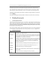
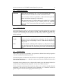
Aeolus
Instruction manual for the
UM-MCIP meteorological pre-processor
G J Taylor
Draft
Document Version: 0.2
Date: July 2006
Instruction manual for the UM-MCIP meteorological pre-processor
1
Title:
Instruction manual for the UM-MCIP meteorological pre-processor
Author:
G. J. Taylor
Aeolus
5 Thornton Close,
Guildford,
Surrey GU2 9XE, UK.
Tel:
+44 (0)1483 505921
e-mail: [email protected]
Date:
12 July, 2006
Prepared for:
University of Hertfordshire
Summary:
This document provides instructions on how to build and run the UMMCIP meteorological pre-processor.
Acknowledgements:
This work has been funded by the Universities Weather Research
Network (UWERN) through a contract placed with, and administered
by, the University of Hertfordshire.
The work is substantially based on the MCIP processor developed by
the US EPA.
The following individuals have contributed to this contract:
Peter Clark, Richard Forbes (JCMM, University of Reading)
Ranjeet Sokhi, Ye Yu (University of Hertfordshire)
Kevin Marsh (BADC, Rutherford Appleton Laboratory)
Chang Wang (UWERN)
G J Taylor
July 2006
Instruction manual for the UM-MCIP meteorological pre-processor
2
All intellectual property rights including without limitation all copyrights, database rights,
patents, design rights, trademark rights and other intellectual property and proprietary rights in
this document and its associated materials and appendices (the "Materials") belong to the
University of Hertfordshire Higher Education Corporation ("UH") or its licensors.
The Materials must not be displayed, modified, adapted, distributed, transmitted, communicated,
copied, transferred, lent, printed off, published or otherwise reproduced either in part or in whole
in any form by any means without the written permission of UH.
UH will use every reasonable effort to ensure that the information contained in the Materials is
accurate at the time you receive it. However, you acknowledge and agree that UH accepts no
liability whatsoever in contract, tort or otherwise for any loss or damage caused by or arising
directly or indirectly in connection with any use or reliance on the contents of the Materials
except to the extent that such liability cannot be excluded by law.
Nothing in these terms shall exclude UH's liability to you for fraudulent misrepresentation by
UH or its employees or for death or personal injury resulting from its negligence or that of its
employees.
These terms shall be governed by and interpreted in accordance with the laws of England and
Wales and you agree to submit to the exclusive jurisdiction of the courts of England and Wales
in respect of any disputes which may arise in relation to the Materials.
Copyright, University of Hertfordshire Higher Education Corporation and its licensors. All
rights reserved.
G J Taylor
July 2006
Instruction manual for the UM-MCIP meteorological pre-processor
3
Contents
1
Introduction
4
2
Building the program
4
3
Running the program
5
4
Utilities
10
5
Input data
11
6
References
13
Appendix 1
14
Appendix 2
15
G J Taylor
July 2006
Instruction manual for the UM-MCIP meteorological pre-processor
1.
4
Introduction
The UM-MCIP meteorological pre-processor allows meteorological data produced by the UK
Meteorological Office’s UM model to be used directly by the CMAQ (Models-3) atmospheric
transport model. As such, it replicates the functionality of the existing MCIP processor,
supplied as part of the Models-3 system, which provides access to data produced by the US
MM5 and WRF meteorological models.
The program is suitable for use with UM data archived at BADC and also with data produced
by the ported version of the model (PUM). It may be used with both ‘meso-scale’ and ‘global’
data.
This document outlines the procedures for building and running the program and also
provides information on the data requirements. A technical description of the pre-processor is
available elsewhere(1).
2.
Building the program
The pre-processor consists of a number of Fortan90 source files. These comprise various files
created specifically to handle the UM data and also some routines from the existing MCIP
processor developed by the EPA. The latter routines have been utilized to allow future
changes to MCIP to be more readily incorporated into the pre-processor.
In addition to the pre-processor, a number of small utility programs is also supplied.
Both the netCDF and Models3-ioapi libraries are required to build the pre-processor. These
are available from http://www.unidata.ucar.edu/software/netcdf/ and
http://www.baronams.com/products/ioapi/ respectively. (The software has been developed
and tested with the netCDF version 3.6.0 and ioapi version 3.0 libraries).
The software is supplied as source code in a single file ‘ummcipv1.tar.gz’. This should be
copied to a suitable source directory and then uncompressed:
tar –xzvf ummcipv1.tar.gz
This will create files in the source directory as well the following directories:
mcip3
documents
utilities
run_script
Make-files are supplied to facilitate the building of both the main pre-processor and the utility
programs. Before use, the make-files should be edited to select the relevant compiler and also
to specify the associated compiler options. Entries are already supplied in the make-files for
the Intel and Portland Group Fortan-90 compilers. In addition, the paths to the netCDF and
Models3-ioapi libraries should also be specified in the make-file for the pre-processor.
The pre-processor may then be built from the source directory using:
make clean; make
This will create the executable (‘ummcip.exe’) in the source directory.
G J Taylor
July 2006
Instruction manual for the UM-MCIP meteorological pre-processor
5
The utilities may be built in a similar fashion using the make-file in the /utilities directory.
(Note: Both of the above build operations create object files in the source directory. Before
either make-file is used for the first time, ‘make clean’ should be used to delete these files).
Alternatively, all the programs may be built in a single pass using the ‘Build_all’ script in the
source directory:
./Build_all
This builds all the programs and creates links to all the necessary files in the /exec directory.
3.
1.
Running the program
Specifying input parameters
All the necessary input to the pre-processor is provided in a single input file ('namelist.ummcip')
which contains the information required to specify the model domain and user-selectable
options. This could clearly be created and edited directly, but a simple script file, ‘run_ummcip’,
is provided (in the /run_script directory) to facilitate the building of the input file and to control
the subsequent execution of the processor.
This script file should be edited to reflect the requirements of the user. The script is designed to
be self-explanatory; detailed information on the various parameters is, however, supplied below.
1.1.
Identifiers and directories:
Run_Id
a brief character string to identify the current pre-processor ‘run’. The string
is appended to the output file-names.
CoordName
a character string to identify the projection and co-ordinate system (defined
in ‚3.1.8 below). The identifier and associated parameters are written into
the GRIDDESC file. [maximum 16 characters]
GridName
a character string to identify the horizontal domain and grid (defined in
‚3.1.6 below) on which the output meteorological data are produced. The
identifier and associated parameters are written into the GRIDDESC file.
[maximum 16 characters]
MetDirIn
the path to the directory containing the UM meteorological files (see ‚3.1.2).
the path to the directory containing the UM ancillary files (see ‚3.1.3).
AnclDirIn
the name of the directory to contain the output files.
OpDirOut
WorkDir
the name of the working directory, where the input file (‘namelist.ummcip’)
is to be created.
the name of the directory containing the ummcip executable.
ExecDir
G J Taylor
July 2006
Instruction manual for the UM-MCIP meteorological pre-processor
1.2.
6
Input meteorology files:
MetFilesIn
a list of the UM meteorology files to be processed (normally relative to the
MetDirIn directory). The files must be listed in chronological order.
The list should be enclosed in parentheses, with the file-names space delimited and with lines separated by a back-slash (\).
(The maximum number of UM files which may be included (25 by default)
is defined by the parameter max_um in umfile_mod.F in the UMMCIP
source code. This value should match that assigned to MaxUmFiles in the
run script).
1.3.
UM ancillary files:
The UM ancillary files contain 2-d, time-invariant data fields which supplement those provided
in the main meteorological files. They must be provided on the same domain and at the same
resolution as the meteorological files themselves. In addition they should be supplied in a bigendian, pp-format.
OrogIn
location of the file containing orographic data (i.e. terrain height [m]).
LandIn
location of the file containing land-use information. The file specifies the
fractional coverage corresponding to each of 9 IGBP land-use categories in
each grid cell.
Z0In
location of the file containing surface-roughness (z0) data [m] for each grid
cell. If this field is left blank, the processor will look for the appropriate field
amongst the data fields for the first time period in the UM meteorological
files.
1.4.
Run-time options:
These options specify how the boundary layer parameters, radiation fluxes and dry deposition
velocities are determined within the processor.
The run-time options are identical to those utilized in the original MCIP program. In most cases
Lpbl and Lrad should be set to 1, so that the boundary layer and surface radiation fields provided
in the UM files are utilized.
Full details of the algorithms used to re-diagnose the boundary layer and radiation fields and to
calculate the species-dependent dry-deposition velocities are available elsewhere(2).
The dry deposition method specified should be chosen to be consistent with the chemical
mechanism to be used in the subsequent CCTM calculations (i.e. it should be selected to
produce deposition velocities for the appropriate chemical species).
G J Taylor
July 2006
Instruction manual for the UM-MCIP meteorological pre-processor
7
Lpbl
determines how the boundary layer (pbl) parameters are determined:
1 - use pbl values from input meteorological fields.
2 - re-diagnose pbl values using pbl-similarity algorithm.
3 - re-diagnose pbl values using surface-similarity method.
Lrad
determines how radiation fields are specified:
1 - use radiation fields from input meteorological files.
2 - re-diagnose radiation fields using MCIPv1 algorithm.
Lddep
specifies the approach to use for calculating dry deposition velocities:
1 – use RADM dry deposition routine.
2 – use Models3 (Pleim) dry deposition method.
3 – use Models3 (Pleim) dry deposition method with Cl species.
2 – use Models3 (Pleim) dry deposition method with Cl and Hg species.
1.5.
Start and end times for analysis:
Ummp_start
Ummp_end
the times and dates of the first and last records to be contained in the output
files. The dates and times should be provided in a character string of the
form: YYY-MO-DD-HH:MI:SS.SSSS. (i.e. 2006-05-28-01:00.00.0000)
No temporal interpolation is carried out within the processor, so the chosen
times should match those of records within the UM input files.
Intvl
the time interval [min] between successive output records. In most cases, this
will just be the time interval between successive records within the UM files.
1.6.
Specify the horizontal domain and grid on which data should be produced:
The processor produces data on a regular, rectangular grid located on a projected plane (rather
than on the surface of the earth). The projection to be used is specified in ‚3.1.8 below. All
locations are then referred to the (possibly false) origin defined by that projection. All
dimensions here should be specified in km.
It should be noted that the processor produces data not only for a simple rectangular domain, but
also on a boundary domain which encloses it. For current purposes this boundary domain is
always 1 cell thick.
XOrig
YOrig
define the location of the ‘dot’ point at the south-west corner of the total
domain (including the boundary domain). These values should be in km.,
measured relative to the projection origin.
NxOut
NyOut
define the dimensions of the total output domain (including the boundary
domain) in terms of the number of ‘dot’ points in the x and y directions. (i.e.
the number of grid cells is NxOut-1,NyOut-1).
DxOut
DyOut
the dimensions of the output grid cells in the x and y directions [km].
Normally, DxOut = DyOut.
G J Taylor
July 2006
Instruction manual for the UM-MCIP meteorological pre-processor
1.7.
8
Specify the vertical levels on which meteorological output data should be produced:
The processor produces data on constant sigma-pressure levels on a hydrostatic, timeindependent, vertical co-ordinate system. The sigma levels are terrain following at the lowest
levels but progressively relax towards horizontal levels at the top of the model domain. The
parameters defining this vertical co-ordinate system are specified in ‚3.1.9 below.
The sigma levels chosen here effectively define the vertical level structure used for the
calculations within CCTM. The processor derives estimates of the meteorological fields on these
levels from values supplied on the UM hybrid height levels by simple linear interpolation. The
choice of the sigma levels thus requires some care. In particular, it is recommended that sigma
levels lying below the lowest hybrid height levels are not specified. In addition, it may be helpful
to choose sigma levels which lie close to the hybrid height levels over the geographical area of
greatest interest, at least over the lower part of the atmosphere.
The sigma co-ordinate system itself is described elsewhere(1,3).
CtmLays
this is a comma-delimited list of the full vertical sigma levels on which data
will be produced in the output files. The list should start with 1.0
(corresponding to the terrain surface) and finish with 0.0 (corresponding to
the top of the model domain). A maximum of 100 levels may currently be
used.
Setting this parameter to a negative value (-1.0, say) will cause the processor
to calculate sigma levels which are consistent with the hybrid height levels
on which the UM data are supplied, assuming a terrain height corresponding
to Zctm (see ‚3.1.9 below).
1.8.
Specify the projected plane containing the horizontal co-ordinate system:
As noted above, the processor produces data on a regular, rectangular grid located on a
projected plane. Three map projections are supported here. The Lambert conformal projection is
generally regarded as most suitable for areas situated in the mid-latitudes. Similarly, the
equatorial Mercator projection is most appropriate for equatorial regions and the polar
stereographic projections for regions near the poles.
All latitude and longitudes are specified in degrees, with -90„ ≤ lat. ≤ +90„ (-ve = southern
hemisphere ); -180„ ≤ long. ≤ 180„ (0 = Greenwich meridian).
Projn
defines the projection to be used:
2 - Lambert conformal conic
3 - equatorial Mercator
4 - polar stereographic
The definition of the following parameters depends on the chosen
projection.
Lambert
Slat1
Slat2
Clat
G J Taylor
1st standard latitude
2nd standard latitude
centre latitude (defines y-origin on projected plane)
July 2006
Instruction manual for the UM-MCIP meteorological pre-processor
Clon
centre longitude (defines x-origin on projected plane)
Mercator
Slat1
Slat2
Clat
Clon
not used
not used
latitude of true scale (defines y-origin of projected system)
longitude of central meridian (defines x-origin of projected system)
Stereographic
Slat1
Slat2
Clat
Clon
Feast
Fnorth
1.9.
9
not used
not used
latitude of true scale (defines y-origin of projected system)
the angle of rotation of the Y-axis relative to the Greenwich meridian, i.e.,
the longitude meridian which becomes the negative Y axis.
false easting, northing (km); re-locates origin so that projection origin is at
(Feast,Fnorth).
Define the vertical co-ordinate system:
As noted above, the program produces data on constant sigma-pressure levels on a hydrostatic,
time-independent, vertical co-ordinate system. This co-ordinate system is discussed
elsewhere(1,3).
The pressure levels are defined with respect to a hydrostatic reference atmosphere. This is
characterized by a surface pressure, P00, at z=0 (normally chosen to be sea-level) and a
corresponding reference temperature, T00, along with a constant assumed adiabatic lapse rate.
It should be noted here that these parameters serve only to define a vertical co-ordinate
system; unlike their use within models such as MM5, they otherwise have no particular
physical significance. Thus, in principle, physically unrealistic values could be chosen for P00,
T00 and Alaps. In practice, though, typical values of P00 = 105Pa, T00 = 290†K, Alaps = 50†K
are normally appropriate.
P00
reference surface pressure [Pa].
T00
reference surface temperature [„K].
Ptop
pressure at model top [Pa]. This defines the vertical extent of the model
domain.
Alaps
adiabatic lapse rate [„K].
Tsit
temperature of isothermal layer in upper part of domain [„K]; not currently
used.
Zctm
1.10.
surface height [m] to use when determining sigma levels which are
consistent with the hybrid height levels utilized in the UM meteorological
files.
Location of cell for diagnostic output:
G J Taylor
July 2006
Instruction manual for the UM-MCIP meteorological pre-processor
10
The processor outputs diagnostic values at the specified array locations.
Lprt_col
Lprt_row
1.11.
(nx,ny) location in the output domain (excluding boundary cells) where
diagnostic output is required. If either value is set to 0, the cell at the centre
of the corresponding row or column will be assumed.
Parameters controlling program behaviour:
The following parameters control the run-time behaviour of the program.
Mkgrid
determines whether the program will output the grid
description file (GRIDDESC) and netCDF files (GRID_**)
containing time-independent geographical and meteorological
data. [Y,N]
IOAPI Environment Variables
LOGFILE
name for the program log-file (optional). This will contain
messages and error reports generated by the Models3 ioapi
library.
IOAPI_CHECK_HEADERS
determines whether the ioapi headers are checked for validity
[Y,N]. Note: setting this flag causes the program to fail within
the ioapi library on some systems!
IOAPI_FILE_WRITE
determines whether message should be produced for each filewrite from ioapi [Y,N].
2.
Executing program
The processor may be executes simply by running the above script:
./run_ummcip
This will produce output in the directories specified in ‚3.1.1 above.
4.
Utilities
A few simple utilities are supplied:
1.
ll2xy and xy2ll
These programs calculate the projected (x,y) co-ordinates corresponding to supplied (lat,long)
values (and vice-versa) for a specified map projection. The map projection should be defined
in a text file ‘prjnparm.txt’ (specimen provided). The projection parameters required here
correspond exactly to those listed in ‚3.1.9 above.
2.
read_ppheader
This program reads a UM meteorological file and lists various items of header information for
each pp-formatted data block. This is useful if difficulties are encountered in accessing the data
G J Taylor
July 2006
Instruction manual for the UM-MCIP meteorological pre-processor
11
through the processor. The meteorological filename may be supplied either as a command-line
argument or via a user prompt.
5.
1.
Input data
UM meteorological data
The UM meteorological data should be supplied in one or more binary files. All the data
corresponding to a particular time should be grouped together, with the data arranged in an
increasing chronological order. It may be convenient to group the data together in separate
files on a daily (or weekly) basis, but this is not essential.
The data should be in a binary, 32-bit pp-formatted form with big-endian byte-ordering. The
above utility, ‘read_ppheader’, may be used to check that the data are correctly formatted. The
X-window utility Xconv (available at http://badc.nerc.ac.uk/help/software/xconv) may also be
used to examine and visualize the data.
The pp-format is a binary record-based format utilized by UK Met. Office as a standard
format and is used in a number of BADC data archives. (Further information is available at
http://badc.nerc.ac.uk/help/formats/pp-format/index.html). In this format a typical record
would consist of the values of a particular field over a defined domain and at a specified
hybrid height level. For present purposes, the required data input file may be considered as
consisting of a series of such records.
The data fields required by UMMCIP are listed in Appendix 1.
1.
Data from BADC archives:
Data fields calculated by the operational version of the Unified Model are archived in a packed
form at BADC. Data are available for both the global and mesoscale domains.
Recent global data (post December 2005) are available on a domain consisting of 50 vertical
layers (extending up to approximately 65km) on a 640 x 481 horizontal grid. The corresponding
horizontal resolution is approximately 40km. Earlier data utilized 38 layers (extending up to
about 40km) and 432 x 325 horizontal grid cells, yielding an horizontal resolution of ca. 60km.
The temporal resolution of these data is 3h. [A utility will be provided to interpolate these data
temporally to yield data at a 1h interval].
The mesoscale domain (http://www.met.rdg.ac.uk/~uwern/UM/domains/index.html) covers
north-west Europe and utilizes 38 layers (extending up to 39km) and a 182 x 146 horizontal
grid, yielding an horizontal resolution of approximately 12km. The interval between successive
output data is 1h.
The operational model is run every 6 hours (i.e. at 0000, 0600, 1200, 1800). The records
corresponding to the start of each forecast period are conventionally referred to as ‘analysis’
states and are denoted as 0ZT+0, 6ZT+0, 12ZT+0 etc. (In reality, each model run is initialized at
T-2, but only the data from T+0 onwards are of interest for forecasting purposes and thus only
such data are archived). The other stored records (i.e. 0ZT+1 … 0ZT+6 etc.) are normally
referred to as ‘forecast’ data.
G J Taylor
July 2006
Instruction manual for the UM-MCIP meteorological pre-processor
12
The archived data may be downloaded from ftp.badc.rl.ac.uk. (The global data may be found at
/badc/ukmo-um/data/global/ag and the mesoscale data at /badc/ukmo-um/data/meso/lb).
The data are archived on both model levels (i.e. hybrid height levels) and pressure levels for both
the analysis and forecast periods. The 3-d data required by UMMCIP are those on the model
levels. The only ‘pressure level’ data utilized are those corresponding to surface fields.
The procedures required to construct a suitable input file for the processor from the archived
data sets are rather laborious. [A script to automate this process is currently being written]. An
outline of the steps required to produce a suitable file manually is, however, included in
Appendix 2.
The required binary pp-formatted data file should contain the data records ordered as 0Z (T+0
… T+6), 6Z(T+0 … T+6) etc. Clearly, 0Z(T+6) and 6Z(T+0) etc. refer to the same hourly
period and data for either T+6 or T+0 may thus be utilized. (If both are included in the file,
the latter item will just overwrite the former). The only exceptions here are the surface
precipitation data. These archived fields contain cumulative precipitation values, from which
must be deduced the incremental precipitations over each time interval. In this case, the T+0
data contain no directly useful information, but are required for initialization purposes. Both
0Z(T+6) and 6Z(T+0) etc. values must thus be supplied. Clearly, no meaningful precipitations
may be derived for the first time period in the file and the precipitation fields are thus set to
zero here.
2.
Data produced by PUM:
Data produced by the Portable Unified Model may also be utilized. A suitable specimen PUM
‘experiment’ and instructions for re-formatting the data will be provided in the near future.
3.
Ancillary files:
In addition to the time varying fields listed in Appendix 1, a number of additional time-invariant
fields contained in ‘ancillary’ files are required (see ‚1.3 above). These contain (i) the
orographical height data (ii) UM fractional land-use based on a sub-set of the IGBP categories
data (vegetative fraction data).
The ancillary files at the required spatial resolution are included with the distribution package,
but may also be downloaded from http://www.met.rdg.ac.uk/~uwern/um_ancil/.
Files containing surface roughness estimates for the global and mesoscale domains are also
included with the distribution package. These are not standard ‘ancillary’ files but are included
for convenience. If these are not available, the surface roughness fields in the BADC archives
(stash code 00026), or the equivalent PUM fields, may be included in the input meteorology file.
G J Taylor
July 2006
Instruction manual for the UM-MCIP meteorological pre-processor
6.
13
References
1. Taylor, G.J., 2006, “Technical description of UM-MCIP”, to be completed.
2. Byun, D.W., Pleim, J.E., Tang, R.T., Bourgeois, Al, 1999, “Meteorology-chemistry
interface processor (MCIP) for Models-3 Community Multiscale Air Quality (CMAQ)
modelling system”, Models-3 Documentation, Chapter 12, EPA Document EPA/600/R99/030
3. Jimy Dudhia, Dave Gill, Kevin Manning, Wei Wang, Cindy Bruyere, 2005,
“PSU/NCAR Mesoscale Modeling System Tutorial Class Notes and Users' Guide
(MM5 Modeling System Version 3)” – Part 1: Introduction, available from
http://www.mmm.ucar.edu/mm5/documents/tutorial-v3-notes.html
G J Taylor
July 2006
Instruction manual for the UM-MCIP meteorological pre-processor
14
Appendix 1
UM variables required by processor
3D variables
u
v
w
Pρ
Pρ
Qv
Qw
Qi
T
Hpbl
z0
Hfx
Tg
Psf
T1.5
Qv(1.5)
σu
σv
G J Taylor
Pressure (theta levels)
Pressure (rho levels)
Specific humidity
Cloud liquid water
Cloud ice content
Temperature
2D Time Dependent Variables
Boundary layer depth
Roughness length
Sensible surface heat flux
Surface temperature
Surface pressure
Temperature at 1.5m
Specific humidity at 1.5m
x component of surface shear stress
y component of surface shear stress
Net downward short wave radiation flux at surface
Total downward short wave radiation flux at surface
Net downward long wave radiation flux at surface
Downward long wave radiation flux at surface
Large scale rainfall rate
Convective rainfall rate
Snow amount over land
Stash Code
2
3
150
408
407
10
4205
4206
16004
25
26
3217
24
409
3236
3237
3219
3220
1201
1235
2201
2207
4201
5201
23
July 2006
Instruction manual for the UM-MCIP meteorological pre-processor
15
Appendix 2
Procedure for producing data files from data archived at BADC
The file required by UMMCIP is just a binary pp file containing the required global or
mesoscale data in the order 0Z(0-6),6Z(0-6),12Z(0-6),18Z(0-6), where 0Z is the analysis hour,
and (0-6) means the hourly forecast fields from that analysis.
The following outline manual procedure may be used to create suitable files. This example
refers to mesoscale data; the global data may, however, be handled in an identical fashion. In
this example it is assumed that all the available archived fields are to be included in the file.
This is not necessary (only those fields listed in Appendix 1 are required). In practice though
it is sometimes easier to adopt this approach.
(1)
download all the mesoscale data from the NWP archive (i.e. model and pressure
levels, analysis and forecast fields). Thus for 27/01/06 retrieve all the files in:
/badc/ukmo-um/data/meso/lb/ap/2006/01/27/*.pp (analysis fields)
/badc/ukmo-um/data/meso/lb/ap/2006/01/27/*.pp " "
/badc/ukmo-um/data/meso/lb/fp/2006/01/27/*.pp (forecast fields)
/badc/ukmo-um/data/meso/lb/fm/2006/01/27/*.pp " "
(2)
concatenate all the analysis fields together for 0Z:
cat lba?2006012700* > 270106_00_00.pp
similarly, concatenate all the 0Z forecast fields together, for each forecast hour (1-6)
cat lbf?2006012700*_01.pp > 270106_00_01.pp
cat lbf?2006012700*_02.pp > 270106_00_02.pp
cat lbf?2006012700*_03.pp> 270106_00_03.pp
... etc
(3)
repeat the above process for 06Z, 12Z, etc., to give a set of files such as:
-rw-r--r-- 1 badc badcint 16196976 Feb 9 13:04 270106_18_06.pp
-rw-r--r-- 1 badc badcint 12314000 Feb 9 13:03 270106_18_05.pp
-rw-r--r-- 1 badc badcint 12339952 Feb 9 13:03 270106_18_04.pp
-rw-r--r-- 1 badc badcint 14197096 Feb 9 13:03 270106_18_03.pp
-rw-r--r-- 1 badc badcint 12403600 Feb 9 13:02 270106_18_02.pp
-rw-r--r-- 1 badc badcint 12428192 Feb 9 13:02 270106_18_01.pp
-rw-r--r-- 1 badc badcint 17342960 Feb 9 13:02 270106_18_00.pp
-rw-r--r-- 1 badc badcint 16306664 Feb 9 13:01 270106_12_06.pp
-rw-r--r-- 1 badc badcint 12386824 Feb 9 13:01 270106_12_05.pp
-rw-r--r-- 1 badc badcint 12402008 Feb 9 13:01 270106_12_04.pp
-rw-r--r-- 1 badc badcint 14245184 Feb 9 13:00 270106_12_03.pp
-rw-r--r-- 1 badc badcint 12418344 Feb 9 13:00 270106_12_02.pp
-rw-r--r-- 1 badc badcint 12435840 Feb 9 13:00 270106_12_01.pp
-rw-r--r-- 1 badc badcint 17360872 Feb 9 12:59 270106_12_00.pp
-rw-r--r-- 1 badc badcint 16315600 Feb 9 12:59 270106_06_06.pp
-rw-r--r-- 1 badc badcint 12399480 Feb 9 12:59 270106_06_05.pp
-rw-r--r-- 1 badc badcint 12421064 Feb 9 12:58 270106_06_04.pp
-rw-r--r-- 1 badc badcint 14288248 Feb 9 12:58 270106_06_03.pp
-rw-r--r-- 1 badc badcint 12463256 Feb 9 12:57 270106_06_02.pp
-rw-r--r-- 1 badc badcint 12476440 Feb 9 12:57 270106_06_01.pp
G J Taylor
July 2006
Instruction manual for the UM-MCIP meteorological pre-processor
-rw-r--r--rw-r--r--rw-r--r--rw-r--r--rw-r--r--rw-r--r--rw-r--r--rw-r--r-(4)
1 badc
1 badc
1 badc
1 badc
1 badc
1 badc
1 badc
1 badc
badcint
badcint
badcint
badcint
badcint
badcint
badcint
badcint
17378640 Feb
16303224 Feb
12361936 Feb
12359904 Feb
14207208 Feb
12351888 Feb
12368000 Feb
17295960 Feb
16
9 12:57 270106_06_00.pp
9 12:56 270106_00_06.pp
9 12:55 270106_00_05.pp
9 12:55 270106_00_04.pp
9 12:55 270106_00_03.pp
9 12:54 270106_00_02.pp
9 12:54 270106_00_01.pp
9 12:53 270106_00_00.pp
combine these to give a single pp file:
cat 270106*.pp > 270106_all.pp.
(5)
this file should then be byte-swapped prior to unpacking. Suitable byte-swapping
utilities are ppflipper.pl and swapbytes, available from :
http://badc.nerc.ac.uk/help/software/xconv/index.html#swapbytes .
If using ppflipper, execute the command:
ppflipper.pl 270106_all.pp >270106_all_swap.pp
to give a file ‘270106_all_swap.pp’ in little-endian form.
(6)
this file should then be unpacked and renamed to give (say)
‘270106_all_swap.pp.unpacked’
(7)
form.
finally, this file should be byte-swapped again to yield the required file in big-endian
[These notes are based on instructions provided by Kevin Marsh of BADC].
G J Taylor
July 2006