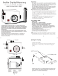
1
OSSIM Users Guide
Version 1.6.5
Open Source Software Image Map – OSSIM, pronounced “Awesome”
Document version 1.1
July 10 , 2006
Written by
Garrett Potts
Mark Lucas
Page 1 of 107
About OSSIM...................................................................................................................... 5
Quick Start Tutorial............................................................................................................ 6
Open the source files................................................................................................................... 8
Managing Windows.................................................................................................................... 9
Pan, Zoom and Propagate in the Displays.............................................................................. 11
Save your project...................................................................................................................... 16
Summary................................................................................................................................... 16
Installing............................................................................................................................17
Binaries...................................................................................................................................... 17
Sample Data.............................................................................................................................. 17
Source Code for Developers..................................................................................................... 18
Preferences Setup...................................................................................................................... 19
Elevation Setup..................................................................................................................................... 19
Sample ossim_preferences file.......................................................................................... 20
Geoid Setup........................................................................................................................................... 22
OSSIM Planetary Viewer Setup (osgPlanet)........................................................................................ 23
Plugin setup........................................................................................................................................... 23
ImageLinker...................................................................................................................... 24
File Menu................................................................................................................................... 25
Open Image........................................................................................................................................... 25
Open Project..........................................................................................................................................26
Close Project......................................................................................................................................... 26
New Project........................................................................................................................................... 26
Save Project........................................................................................................................................... 26
Save Project As......................................................................................................................................26
Display Menus........................................................................................................................... 26
Zoom and Pan Modes............................................................................................................................27
Fit.......................................................................................................................................................... 27
Full Res................................................................................................................................................. 27
Propagate............................................................................................................................................... 28
View...................................................................................................................................................... 28
Geometry Adjustment........................................................................................................................... 29
Image Chain.......................................................................................................................................... 31
Image Info............................................................................................................................................. 33
Drop Point GUI..................................................................................................................................... 36
Image Generation..................................................................................................................... 40
Swipe Menu............................................................................................................................... 45
Add Layer..............................................................................................................................................45
Remove Layer....................................................................................................................................... 46
Horizontal..............................................................................................................................................46
Page 2 of 107
Vertical.................................................................................................................................................. 46
Enhancements Menu................................................................................................................ 47
Band Selection...................................................................................................................................... 47
Brightness Contrast............................................................................................................................... 48
Correction-->Topographic..................................................................................................................... 48
Histogram Operations........................................................................................................................... 49
Hue Saturation Intensity Adjustments................................................................................................... 50
Propagate Resampler............................................................................................................................. 50
Layer Menu............................................................................................................................... 51
Manager................................................................................................................................................. 52
Histogram Match................................................................................................................................... 53
Combine................................................................................................................................................ 54
Fusion.................................................................................................................................................... 56
Hill shading........................................................................................................................................... 60
Vce Menu................................................................................................................................... 63
VCE Components..................................................................................................................................64
Chain Editor Window............................................................................................................................65
Utilities Menu............................................................................................................................ 74
Elevation Manager................................................................................................................................ 74
Unit Converter....................................................................................................................................... 75
Window Menu........................................................................................................................... 76
osgPlanet............................................................................................................................77
OSSIM Internals............................................................................................................... 77
Dynamic Image Chains............................................................................................................ 77
File formats supported............................................................................................................. 78
Projections and Transformations Supported......................................................................... 79
LAM/MPI.................................................................................................................................. 80
Command-line Applications............................................................................................. 80
icp............................................................................................................................................... 82
orthoigen.................................................................................................................................... 85
Reprojection.......................................................................................................................................... 89
Mosaicing.............................................................................................................................................. 91
Histogram.............................................................................................................................................. 93
Cut and Resample..................................................................................................................................94
Tiling..................................................................................................................................................... 95
Writer template...................................................................................................................................... 98
image_info............................................................................................................................... 100
img2rr...................................................................................................................................... 101
create_histo............................................................................................................................. 102
cmm.......................................................................................................................................... 102
Page 3 of 107
ogeom2ogeom.......................................................................................................................... 104
applanix2ogeom...................................................................................................................... 105
igen........................................................................................................................................... 107
1
Page 4 of 107
2 About OSSIM
This document provides an overview of the Open Source Software Image Map
(OSSIM) project http://www.ossim.org . OSSIM is a contrived acronym
pronounced “Awesome”. The core of OSSIM is a C++ software library that
provides advanced remote sensing, image processing, and geo-spatial
functionality. A quick summary of OSSIM functionality includes orthorectification, precision terrain correction, rigorous sensor models, very large
mosaics, and cross sensor fusions, a wide range of map projections and
datums, and a large range of commercial and government data formats.
The architecture of the library supports parallel processing with mpi, a dynamic
plugin architecture, and dynamically connectable objects allowing rapid
prototyping of custom image processing chains.
Around the core ossim library, the software distribution includes a large number
of command line utilities that can be easily scripted for batch production systems
and higher level GUI applications – imagelinker, and iview. Additionally, bindings
have been generated for other languages.
Also included in the distribution are the osgPlanet and osgPlanet_qt modules.
These modules build on top of OSSIM and OpenSceneGraph to provide geospatially accurate 3D visualization capabilities.
On 4 Feb 2006, the Open Source Geospatial Foundation http://www.osgeo.org
was formed in Chicago IL. The OSSIM project joined the OSGF as one of the
founding projects. Future efforts will integrate these projects into formidable
open source image processing, mapping,
and GIS systems.
Page 5 of 107
3 Quick Start Tutorial
One of the best ways to understand the power of the OSSIM library is to
demonstrate it through the ImageLinker application. ImageLinker was originally
developed as a prototyping tool to test and demonstrate the power of the OSSIM
library. It has a graphical user interface implemented using the Trolltech Qt
library and runs on any platform supported by them – Windows, Linux, Solaris,
Mac OSX.
Figure 1 Combiners in the Quickstart Tutorial
This quick walk through will demonstrate just a few of the capabilities of OSSIM
and ImageLinker. It is designed so that the user can follow along with step-bystep instructions using the available sample data sets. The tutorial will
demonstrate different ways to combine a map and satellite image.
OSSIM and ImageLinker provide several ways to combine geo-spatial data sets.
This exercise will demonstrate simple mosaics, blends, and feathers with a map
and image of the San Francisco area. The data sets in this example are part of
the sample data set that is available on ossim.telascience.org/ossimdata (see
section 3.2 for download instructions).
Page 6 of 107
Refer to the Installing section 3 of this document for instructions on how to get
and install the software for your platform. For this example we will use the
Landsat image and raster map of San Francisco:
Uncompressing the demodata.tgz file on ossim.telascience.org/ossimdata you
should find the following:
sanfran/sanfran.ccf
sanfran_map/highres_utm_map.tif
These files have been prepared as a test set for the quickstart guide to the
ImageLinker program. ImageLinker will take advantage of auxiliary files if they
are present. There are several OSSIM command utilities to create these files for
data setsThe initial files were sanfran.tif and highres_utm_map.tif - both geotiff
files. GeoTiffs are tiffs that have geospatial tags embedded in the file.
The respective ovr files are overview files containing reduced resolutions sets.
These files can be generated with the img2rr (image to reduced resolution)
command line utility. The geom files contain geometry information and were
created with the create_geom command.
Histogram files can be created with create_histo or can be created when initially
ingested into ImageLinker.
The readme.txt files are human readable files about the data sets.
These two files will be used to demonstrate some of the basics of ImageLinker.
So start up ImageLinker and follow the following steps in the rest of this section.
Page 7 of 107
3.1 Open the source files
Open the data files for the map and UTM projected color fused Landsat image of
San Francisco by navigating the file browser to your test_data installation and
open them. The following command assumes they are located in <install
location>/test_data.
File->Open, navigate to test_data/sanfran/san_fran.tif
File->Open, navigate to test_data/sanfran_map/
highres_utm_map.tif
The ImageLinker canvas should reflect that the map and the Landsat image have been
loaded.
Figure 2 Initial opening of the UTM projected San Francisco Landsat (left) and the San
Francisco map (right).
Page 8 of 107
3.2 Managing Windows
In this introductory tutorial we will get a feel for some of the window management
and display commands. Each project in ImageLinker lives in its own canvas.
Standard maximize, minimize and collapse menu options work on the project
canvas within the desktop. Additionally, there are a couple of useful commands
for organizing the windows. Lets try a couple.
Select Window->Cascade
The open displays are cascaded within the project canvas.
Figure 3 Cascade.
Select Window->Minimize All
Collapses the displays into the bottom of the Canvas.
Figure 4 Minimize all.
Page 9 of 107
Select Window->Restore All
Will restore the minimized images to their original location.
To place the images side by side use the Tile menu command
Select Window->Tile
Figure 5 Tiled.
Page 10 of 107
3.3 Pan, Zoom and Propagate in the Displays
The displays have several modes and capabilities that make it easy to navigate and
synchronize displays within a project. In the center of the Landsat scene is Treasure
Island, place the cursor over the island and click. Note that the Latitude and Longitude of
the mouse click is displayed at the bottom of the window. For more thorough position
information open the Edit->Position information menu option found on the display
window.
Click on Treasure Island
Click on the Full res button
You should see a display similar to that shown above. Note the tracking cursor lines in
the map display track the geographic location of your cursor. Tracking cursors will
appear in all geographically coincident windows.
Figure 6 Full resolution of the Landsat San Francisco
Note: Depending on the data set you are using, your view may differ slightly. The test_data.tgz
data set has been downsampled and therefore will display at a 15m versus 5m resolution when
zooming to full resolution.
Page 11 of 107
In the Image Window Press the Propagate Button
The geometric view is updated in all open windows to the same scale and orientation.
You can toggle the cursor modes between zoom and Pan with the icon buttons at the top
of the display for general navigation.
Figure 7 Full resolution of the Landsat San Francisco scene propagated to all other
displays.
With the displays zoomed to treasure island, as
shown above, blend the views. In the main menu
select Blend under the Combine submenu under
the Layer menu.
Layer->Combine->Blend
Figure 8 Combine->Blend menu option
A dialog box will appear with a list of image chains
that can be combined. Select both the map and the image and press the Apply button.
Page 12 of 107
Figure 9 Blend layer chooser.
A new display appears that is blended, press the Fit button on the new display
to get an overview. You will notice that the data sets are blended together in the
overlap area.
Figure 10 Blended layers.
Page 13 of 107
Tile the windows by pressing the menu option Window-->Tile and in the Landsat
image window press the Propagate button.
The view is propagated to the blend and map windows.
Figure 11 Blended layers tiled and propagated.
Minimize the source windows for the map and Landsat image by clicking in their
display minimize buttons. This should leave only the blended display. Now we
will create feathered and mosaic displays.
Layer-Combine->Mosaic and select just the map and Landsat image chains
Figure 12 Mosaic layer chooser.
Page 14 of 107
Press the Apply button
Next we will go ahead and create a feathered display as well. In similar fashion
select the menu option
Layer->Combine->Feather.
Again, just select the first two lines - the source files and press the Apply button.
Clean up the displays by selecting Window->Tile.
Select any of the displays, press the Fit button, then press the Propagate button
and you should end up with something similar to this:
Figure 13 Three basic mosaics.
The difference between these three combiners is how it treats pixels in the
overlap area. A mosaic simply chooses one source over the others, the blend
averages the values of the pixels, and the feather changes the blend gradually as
the distance from the seam increases. To change the weighting, sources, or any
relevant adjustable parameters, select the desired display and Edit->Layers to
bring up the appropriate dialog box.
Page 15 of 107
3.4 Save your project
Main Window File->Save Project as mapblend.prj.
3.5 Summary
This completes the quickstart tutorial for some of the combiner algorithms
available in OSSIM and ImageLinker. Using a map and image of San Francisco
we demonstrated basic navigation of displays and window management tools in
ImageLinker, followed by the creation of various types of mosaics and overlap
area combiners. These types of products are very easy to create in the tool sets.
OSSIM automatically handles differences in input resolution, projections, file
formats and radiometry types. Transformations are performed automatically to
produce the product needed by any given display. Adjustable parameters can be
accessed and modified through the Layer->Edit menu of any display. Covered in
more detail later, any display can generate a product through the File->save as
command.
Page 16 of 107
4 Installing
This section describes how to download and install the OSSIM software. OSSIM
is hosted at www.ossim.org. There you will find download links for the source
code and and binaries. If you are only interested in running the software, then
download the binary installer for your platform. If you are a developer and want
to build the software yourself, you have the option of downloading the latest
stable release version from the download site or checking the latest repository
from the CVS tree.
4.1 Binaries
The easiest way to get up and running is to download the binary installer for your
platform, double click, and follow the instructions. The binary package installers
are available for many of the common platforms. The binary packagers will
typically install the OSSIM library in the proper system location, command line
utilities, and the ImageLinker and Iview applications. Most users will want to start
with the ImageLinker application to get a better feel for the capabilities of the
OSSIM package.
4.2 Sample Data
You can download the test data at ossim.telascience.org/ossimdata
demodata.tgz - full rez (large) map and image
test_data.tgz - test data as shown below
Some of the directories you should see listed in test_data.tgz are:
doqq
doqq_overlapping
drg
elevation
geoid03
geoid96
geoid99
katrina
orthoigen
sanfran
sanfran_map
These test sets are used throughout the users guide. Each directory is
explained:
Page 17 of 107
doqq directory is used to demonstrate the fusion algorithms(see section 4.6.4
Fusion below). You should see a 5 meter color image and a 1 meter grey-scale
image of the same area. This is used to simulate a 1 meter high-resolution color
product by using the 1 meter grey-scale image for detail enhancement.
doqq_overlapping directory has 4 tiles that overlap each other. This is used to
show different mosaics.
drg directory holds an image without geometry. This is used to show how to drop
ground points to create an ossim projection (see section 4.2.9 ).
elevation directory holds a couple 30 meter cells SRTM cells.
geoid03 directory holding NGS distributed geoid 2003 grids.
geoid99 directory holding NGS distributed geoid 1999 grids.
geoid96 directory holding the geoid 96 grid distributed by geotrans.
katrina directory holding some sample aerial data for hurricane Katrina.
Example of the Applanix sensor model.
orthoigen directory holds the sample keywordlists and tile data files to run the
samples in the orthoigen section 7.2.
sanfran directory holds a 5 meter color product originally created from a color
Landsat and Spot fusion
sanfran_map directory that contains a UTM map of the San Francisco area.
4.3 Source Code for Developers
The main site for accessing the source download link is at www.ossim.org. Selecting the
downloads will take you to the sourceforge project tree. The released source code is
available for download and also contains dependency source code.
For CVS access we host and own the following modules:
ossim
ossim_qt
ossim_plugins
libwms
osgPlanet
osgplanet_qt
Page 18 of 107
4.4 Preferences Setup
OSSIM preference file are global preferences for all command line a GUI
applications. Preferences are enabled either by passing the file as command line
using the –P option or bey specifying it as an environment variable
OSSIM_PREFS_FILE. Assume you have a preference file stored at /home/
myaccount/ossim_preferences then you can set your environment variable
OSSIM_PREFS_FILE=/home/myaccount/ossim_preferences or pass as
command line options –P /home/myaccount/ossim_preferences.
4.4.1 Elevation Setup
OSSIM supports loading of SRTM and DTED elevation data.
Let’s assume you placed the test_data under c:\ossim\test_data
elevation_source1.filename: c:\ossim\test_data\elevation\srtm\1arc
elevation_source1.type: srtm_directory
Note: elevation_source1.type is optional and if not present it will use autodetection to determine the type. The other supported type is dted_directory,
srtm_cell, and dted_cell. For an up-to-date keyword list template please look in
source distribution ossim/etc/templates/ossim_preferences_template for a
complete list of supported detectors.
If you have other source directories for elevation you just increment the number
and add another one:
elevation_source2.filename: …..
elevation_source<n>.filename: …
You can mix SRTM and DTED, and OSSIM will handle it. Note: Elevation
lookups will be in the order you specified. So if you have SRTM 30 meter and
DTED 30 meter and you have a cell that overlaps a lat lon value then it will use
the first one in the list and if the height is NULL/Invalid then it will go to the next
manager in the list until a valid height is found. Currently, they are assumed to
be relative to a geoid grid (Mean Sea Level).
Other keywords that can be controlled are:
elevation.enabled: true
elevation.auto_load_dted.enabled: true
elevation.auto_sort.enabled: true
elevation.compute_statistics.enabled: true
------------------------------------------------------------------------
Page 19 of 107
5
Sample ossim_preferences file
// $Id: ossim_preferences_template,v 1.11 2003/03/27 20:51:20 gpotts Exp $
//
// Description: ossim_preferences_template
//
// This file will be automatically loaded by ossim applications provided the
// environment variable “OSSIM_PREFS_FILE” is set to point to some form of
// this file.
//
// Note: c++ comments “//” can be used to comment a line.
//
// To set the environment variable for automatic preference file loading:
//
// This assumes a preference file in your home called “ossim_preferences”.
// Typically this would be put in a dot file read at startup of a shell.
//
// tcsh and csh users: setenv OSSIM_PREFS_FILE ~/ossim_preferences
//
// bash and sh users:
export OSSIM_PREFS_FILE=~/ossim_preferences
//
// windoze users:
I’ll have to look this up...
//
// You can also use the “-P <preference_file>” option at application startup.
// where <preference_file> is full path and filename.
//
// -----------------------------------------------------------------------// --// Keyword:
dted_directory
// Path to DTED elevation cells. Can have more than one diretory.
dted_directory1: /Data/ele1/DTED3arc
dted_directory2: /Data/ele1/DTED1kps
// ---
//
//
//
//
--Keyword: dted_cell
Path to a DTED elevation cell.
---
// --// Keyword: default_elevation_path
// Default path for the elevation manager popup “Add” to start at.
default_elevation_path: /Data/ele1
// --// --// Keyword:
elevation.enabled
Page 20 of 107
// If disabled calls to the elevation manager getHeightAboveMSL and
// getHeightAboveEllipsoid will return a null height. (default=true)
// Use: “true”, “yes”, “y” or “1” to enable,
//
“false”, “no”, “n” or “0” to disable.
elevation.enabled:
// --// --// Keyword:
true
elevation.auto_load_dted.enabled
// Enable autoloading of dted elevation as need from above directories.
// (default=true)
// Use: “true”, “yes”, “y” or “1” to enable,
//
“false”, “no”, “n” or “0” to disable.
elevation.auto_load_dted.enabled: true
// --// --// Keyword: elevation.auto_sort.enabled
// Enable sorting of elevation cells on an add by the lowest(best) mean post
// spacing. (default=true)
// Use: “true”, “yes”, “y” or “1” to enable,
//
“false”, “no”, “n” or “0” to disable.
elevation.auto_sort.enabled: true
// --// --// Geoid support
// --// GEOID 99: Set keyword to the directory containing the GEOID 99 grids.
geoid_99_directory: /data/ele1/geoid/geoid99
// GEOID EGM 96: Set keyword to the path to the egm96.grd
geoid_egm_96_grid: /data/ele1/geoid/geoid96/egm96.grd
// --// font support
//
//font.file1: /usr/share/fonts/default/Type1/b018032l.pfb
//font.dir1: /usr/share/fonts/default/Type1
// for MacOSX
font.file1: /System/Library/Fonts/Helvetica.dfont
font.dir1: /System/Library/Fonts
// plugin support
// plugin.dir1: /work/gpotts/ossim-plugin
// You can also list files individually
plugin.file1:/Users/Shared/Development/imglnk/lib/libossim_plugins.dylib
Page 21 of 107
//--// Keywords for plugin registration.
//
// plugin.dir1: < directory where plugins are >
//
// you can also list by individual file names
//
// plugin.file1: < full path and file name >
// -------------------------// Some keywords for the OSSIM GUI application
//
//
// igen spec files output./ This is the directory location you would
// like the igen export GUI to default to when outputing spec files
ossim.igen_spec_output_directory: /work/gpotts/igen_test
// this is the igen executable. Make sure you put the full path
ossim.igen_executable: /work/gpotts/ossim/bin/igen
// END KEywords for OSSIM GUI
//--------------------------
5.1.1 Geoid Setup
Current version supports the 96, 99, and 2003 grids. The 99 and 2003 grids are
distribution from NGS and the 96 grid was a distribution from Geotrans. Assuming you
have downloaded the test_data and have it saved to c:\ossim then you should have a
geoid96, geoid99 and a geoid03 under the c:\ossim\test_data directory. For 96 geoid
support use
geoid_egm_96_grid: c:\ossim\test_data\geoid96\egm96.grd
The 1999 grids and 2003 grids are NGS distributions and use the keyword:
Geoid_ngs_directory: c:\ossim\test_data\geoid99
geoid_ngs_directory.byte_order: big_endian
Or
Geoid_ngs_directory: c:\ossim\test_data\geoid03
geoid_ngs_directory.byte_order: big_endian
Page 22 of 107
In future releases we will support multiple geoid directories and searching for
correct geoids to use. For now you can only use one or the other.
5.1.2 OSSIM Planetary Viewer Setup (osgPlanet)
The windows binary installer will automatically setup the preference file with a
default low-resolution background reference image. This will be used as the
base texture map for the earth. For other platforms the keywords may have to be
added manually to your preference file:
ossimosgplanet.background.type: local
ossimosgplanet.background.file0: C:\Program Files\Common Files\ossim
\images\earth.tif
ossimosgplanet.background.transparent_color_flag:0
ossimosgplanet.background.transparent_color: 0 0 0
ossimosgplanet.background.opacity: 255
The type currently should be local and the files can be listed with first keyword
starting at file0 and going to file<n>. You can have any number of images as a
background reference, and can be any image loadable by the OSSIM core
library.
5.1.3 Plugin setup
At the time of this document a Geospatial Data Access Library (GDAL) was the
only supported plugin. I t gives access to a host of other data formats. Under
windows this is automatically setup for you. Here is a sample of the keywords for
unix:
plugin.file1: /Users/Shared/Development/ossim_plugins/lib/
libossimgdal_plugin.dylib
If you are working from the latest snapshot there is a registration plugin started:
plugin.file2: /Users/Shared/Development/ossim_plugins/lib/libossimreg_plugin.dylib
Page 23 of 107
6 ImageLinker
ImageLinker is a GUI based application demonstrating the power of the OSSIM open
source software library. It is one of many programs that have been built on top of the
functionality in OSSIM. Users are encouraged to register online at http://www.ossim.org
and join the collaborative community there. The site is the focal point for software
development, user support, and related information.
ImageLinker is an application for viewing and processing remote sensing and
Geographical Information System (GIS) data built on the underlying OSSIM
library. Capabilities include advanced remote sensing, photogrammetry, and
image processing. Underlying design goals and capabilities are covered in more
detail in the Design Goals section of this document.
ImageLinker brings out many of the underlying functions through commands that
are accessed through pull down menus and dialogs. ImageLinker also allows the
user to construct and manipulate complex image flows through the Visual Chain
Editor (VCE). The VCE allows the user to dynamically connect and re-order
multiple “image chains” through the visual chain editor canvas. Each function is
represented by a thumbnail that reflects the state of the imagery at that point.
Users can double click any function to access custom dialogs and parameters.
Projects can be saved and retrieved at will and later used as processing
templates for batch processing.
ImageLinker also supports a plugin architecture that allows new functions and
processes to be loaded at runtime. The design of the plugins allows scientists
and developers to quickly add new functionality without the need of learning the
internals of the OSSIM software libraries.
In addition to viewing and manipulating image chains, ImageLinker can generate
output products by passing the parameters to the igen command line tool (called
through menu commands).
ImageLinker and OSSIM are open source software projects that are being widely
deployed in various government and commercial organizations.
Page 24 of 107
6.1 File Menu
Figure 14 File menu from Windows version of ImageLinker.
The project menus contains all of the commands necessary to loading,
saving,closing and creation of new projects. Project files can be thought of as
sessions. Multiple images can be loaded and filters and parameters can be
applied to their respective image chains. All of these settings including window
positions and user settings are captured and saved at will when the user saves a
project. A project typically has a .prj extension.
6.1.1 Open Image
File->Open Image will bring up a file browser dialog. This is a multi-selection file
browser allowing one to select more than one image to import. Drag-and-drop is
supported by ImageLinker and is another alternative to the file browsing option
for data loading. All data loaded into ImageLinker will be stored into the global
Layer Manager.
Figure 15 San Francisco image opened through the “File->Open Image” menu
option. Image is part of the test data distribution under sanfran/sanfran.ccf.
Page 25 of 107
The display windows have a number of capabilities and menus that can
manipulate the underlying image chain for the display.
Each display window contains a title bar that denotes the source. Display menus
and menu items operate on the underlying image chain for the window. The
window also has a number of modes for panning and zooming. When a display
is initially created, it determines if there is an underlying geographic context
associated with the imagery. If none is available through associated metadata or
internal geo-specific tags, a dialog is presented to the user asking if a default
geographic projection should be assigned to the image.
6.1.2 Open Project
The Open command invokes a file navigation dialog allowing the user to navigate
the file system and open a .prj project file. A project file saves the state of your
session so that you can retrieve it later. OSSIM also supports drag-and-drop of
project files. It will first close the current project and open the new project file.
6.1.3 Close Project
Closes the active project and asks if you would like to save the project file.
6.1.4 New Project
Creates a new project and associated project window.
6.1.5 Save Project
Saves the current project and invokes a dialog box if the project hasn’t been
assigned a name.
6.1.6 Save Project As
Invokes a Save dialog box and allows the user to assign a new name to the
project.
6.2 Display Menus
When the File->Open Image menu is invoked the image comes up in a display
window. Several menu options are available for advanced image manipulation.
Figure 16 Image display menu options and toolbar buttons.
Page 26 of 107
On the top row we have the basic file, edit, swipe, enhancements, and help menu
options. On the second row we have a toolbar with quick access to zooming,
panning, fitting, full resolution, propagate, refresh and specification of the
resampling type. Each are explained in further details.
6.2.1 Zoom and Pan Modes
The window palette contains two icons for selecting zooming and panning modes
for the display. Select the mode then control by clicking with the left mouse
button in the content of a display.
When in the zoom mode, clicking in the window will do a power of 2 zoom in.
Shift click will cause a power of 2 zoom out. Dragging a rectangular area will
zoom the display to that area of interest and if the shift is used then it will zoom
out.
When in the pan mode, clicking in the window will re-center the view to the
clicked position. This is not the case if the image is already “fit” to the current
view window.
6.2.2 Fit
The Fit button calculates and scales the image so that the entire coverage is
visible in the display window as shown above in Figure 15. In this example a
Landsat image has been scaled to fit in the display windows.
6.2.3 Full Res
Figure 17 Click on treasure island in the left image and then click the full res
button.
The “Full res” button scales the image to full resolution centered about the last
cursor click in the window. Each geographic image has a full resolution
parameter, which defines the native resolution mode of the data set. In this
example the Landsat image on the left was zoomed to full resolution.
Page 27 of 107
6.2.4 Propagate
Figure 18 Propagate the view of the left image to all other opened displays.
The propagate mode syncs the views of coincident geographic data sets to the
same scale and resolution as the selected window. It transmits a command to
the other windows to present themselves in the same view as the window where
the button was pressed.
In this example the full resolution view of the Landsat image on the left was
propagated to the map on the right. Both images are presented in the same
scale and area of coverage.
7
View
Accessing Edit->View will bring up the view dialog box.
Figure 19 View dialog box.
Page 28 of 107
This dialog displays and modifies the view projection of the displayed image.
Currently only map products are supported. Transforming to another projection /
datum is as simple as selecting the desired output from the pull down menus.
Parameters for resolution, origin, … etc are also available from this dialog. The
OSSIM application is projection and resolution independent. All transformations
and resamplings are performed automatically to meet the needs of any display.
To apply changes you can either hit the return key or click on the apply button.
The propagate button takes the same action as the propagate button on the
display window. It will take the current view setting and propagate to all other
displays.
7.1.1 Geometry Adjustment
Geometry adjustments allow for manual tweaking of mis-registered images. If
the input is coming from a sensor supported by OSSIM you can apply geometry
adjustments to the image. Supplied under the katrina directory are two Applanix
images that are loaded through the Applanix sensor model and can be fine-tuned
with the geometry adjustment interface.
Figure 20 Geometry adjustments for the katrina image.
The Adjustment selection allows you to switch between different adjustments.
Each adjustment can have a description by editing the Adjustment description
field.
This dialog is available for sources that are derived with sensor models. OSSIM
has support for rigorous sensor models and adjustable parameters. Each
parameter has 5 attributes: Name, Sigma, adjustable param, param adjustment
slider, and the calculated value. Not shown is the parameters center. The
calculation of each parameter is computed as:
value = center + param*sigma
Each field can be edited and changed. The slider is there for convenience and if
you need to have more precision then you need to hand edit the field in the
Page 29 of 107
param column. The bottom of the dialog we have the buttons apply, keep, copy,
delete, reset, save, and close.
The apply button will apply the current adjustments to the image. This is not
needed if the auto apply button is enabled. If the auto apply is enabled then the
image changes immediately when any parameter changes. This is true by
default.
The keep button will make a copy and re-center the adjustments. So if you
move the top slider over and hit “keep” button it will make a copy of the
adjustment, adjust the center to that value, reset the param back to 0:
center = center + param*sigma
param = 0
You can go back to the previous adjustment by selecting the adjustment number
in the adjustment selection at the top of the dialog.
The copy button simply makes a copy of the current adjustment. The previous
adjustment can be retrieved through the adjustment selection list at the top of the
dialog.
The delete button will delete the current adjustment. If the current adjustment is
the first adjustment it will simply reset the adjustment to the initial condition.
The reset button will reset the current adjustment to the sensors initial
adjustment values.
The save button will write the adjustments to disk. This is important if you want
your adjustments to stick around for future use or for use by external OSSIM
applications. By default it should fill the correct <filename>.geom file in the file
browser dialog.
The close button will close the dialog box.
Page 30 of 107
7.1.2 Image Chain
In the image window selecting the menu option Edit->Image Chain will bring up
the image chain editor.
Figure 21 Image window image chain. The left are filters that you can add to the
current chain and on the right is the current processing chain for the window.
OSSIM supports dynamic image chains. This will become more apparent later in
the demonstration with the visual chain editor (see section 4.7). An image chain
typically begins with a geo-spatial file on disk and is connected through a series
of band selectors, caches, filters, and resamplers. This dialog shows the current
image chain (right side) associated with the particular display. The left hand list
contains all the registered filters in OSSIM.
Using the San Francisco image in Figure 15 we can add an edge detector to the
chain by first selecting the “EdgeFilter” in the available filters list and then select
the ccf filter on the “image chain” list
Page 31 of 107
Figure 22 Chain editor. Select EdgeFilter left and select the image handler ccf on
the right. Top is the input source followed by the rest of the processing filters.
and then do an insert after
Figure 23 Chain editor. EdgeFilter “inserted after” the selected ccf image handler.
Page 32 of 107
and finally the result.:
Figure 24 Result of inserting the EdgeFilter.
7.1.3 Image Info
Selecting the edit->image info menu option will bring up the image information
window for the current image in the display.
Page 33 of 107
Figure 25 Image information window. Brought up through the edit->image info
menu option on the Image display window.
This dialog contains geometry, projection and vertex information on the displayed
image. The scan for min max is currently disabled and can only be ran by the
external application cmm, which stands for compute min max. Each section is
available through the tabbed interfaces on the dialog.
The Image Projection tab shows the images input projection information.
Page 34 of 107
Figure 26 Image information window “Image Projection” tab.
Image Projection information is currently only given for map projected data.
Finally, valid vertices are displayed by selecting the Valid Vertices tab:
Figure 27 Image information window “Valid Vertices” tab.
The Valid Vertices tab displays the images valid vertices. Many time such as
Landsat scenes the images have large NULL areas since the image is rotated.
The valid vertices can specify the valid corner points. This is currently for visual
purposes only and cannot be edited here.
Page 35 of 107
7.1.4 Drop Point GUI
If you would like to follow the steps here please remove the file test_data/drg/
battlmn.geom.
If this is not the first time running this part and you want to see how to do a drop
point projection then remove the file test_data/drg/battlemn.geom. Next, load the
image test_data/drg/battlmn.tif and say yes to create a default projection.
Figure 28 Load image test_data/drg/battlemn.tif
The loaded image should look like this:
Figure 29 Loaded image
Page 36 of 107
Zoom to full resolution to the upper left corner of the image.
Figure 30 Zoomed to full resolution to the upper left corner.
Figure 31 Access ImageInfo menu option
Page 37 of 107
Go to the edit->image info menu option and select the Image Projection tab
and select the ossimBilinearProjection class.
Figure 32 Change to a bilinear projection.
Once selected you will be prompted to edit the projection by using the drop point
GUI. This projection requires 4 points.
Figure 33 Question box when changing to a bilinear projection.
Select Yes and the bilinear projection drop-point dialog will come up.
Page 38 of 107
Figure 34 Drop point GUI.
Selecting in the window will add an adjustment to the dialog. Select the in the
corner of the cross section where 41 degrees North and 117 degrees west meet.
Figure 35 Popup that comes up when selecting, with the left mouse button, in the
image window.
Selecting yes will add the line and sample to the selected row. Type in the lat lon
location.
Figure 36 Drop point GUI.
Page 39 of 107
Repeat for all 4 corners of the image and then hit save the geometry to test_data/
drg/battlemn.geom. You now have a projection in OSSIM and you can output
the product to a geotiff.
7.2 Image Generation
Figure 37 File menu under the Image display.
The File->Save As allows the user to set parameters for product output, save
those specifications to an external spec file and/or save the image to disk.
When the File->Save As menu option is hit the product output dialog box comes
up:
Figure 38 Image generation dialog.
Once this dialog is up it will link to the current display. Initially you should se a
white bounding rect covering the entire scene. There are several was to change
the dimensions of the rectangle or redoing of interest. Try changing the scale
field in the Image generator dialog box to 5.
Page 40 of 107
Figure 39 Scale changed to 5 meters. Region of interest box changes dimensions.
Notice the rectangle box changes size to match the scale estimate. Now
change the dimensions of the box by entering 1024 in the lines field and 1024 in
the samples. Make sure you hit return in each field or the change will not take
affect.
Figure 40 Lines and samples changed to 1024x1024. Region of interest box
changes dimensions.
You can also move the box with your middle mouse button. Move the mouse
over the box and press and hold down the middle mouse button and drag the
box. The box should change to a green color. Once you have the box moved to
the desired location release the middle mouse button. In this example we
moved the box over Treasure Island.
Page 41 of 107
Figure 41 Box moved over Treasure Island in the San Francisco image.
Using the left mouse button can create a custom box. Press and hold the left
button down while dragging. A box should be created. When you have reached
the desired size release the mouse button.
Figure 42 Custom bounding box drawn using the left mouse button.
The use scene rect button located in the Image Generator dialog box will stretch
the region of interest to cover the entire scene. The scale is in meters and
corresponds to the meters per pixel product output. The output Image field has
a file browse button indicated by the three dots. When pressed it will open up a
file browser to identify the location of your product. If you edit this field manually
without the file browser you must hit return in order for the change to take affect.
Also note, we currently do not automatically set the correct extension based on
Page 42 of 107
writer type and you must specify it. The output writer type will have a list of
output types to choose.
Figure 43 Image generation dialog writer type selection.
Once the writer type is selected, individual properties can be edited by selecting
the edit writer button:
Figure 44 Writer property list.
Page 43 of 107
If the GDAL plugin is enabled then you can select other writer types related to
GDAL. For example gdal_HFA will allow you to output an imagine formatted file:
Figure 45 Writer property list for the gdal_HFA output type.
To see the supporting formats of the GDAL plugin see Main Menu->File>preferences or under MACS see Main Menu->ImageLinker->Preferences.
The final product can be saved by hitting the save image button. It will save the
image and immediately after saving bring it back up into ImageLinker for further
viewing/processing. If you are using imagelinker to create a very large mosaic
and your output product will take a long time to execute then it might make since
to output the spec file only by pressing the save spec file only button. The file
you output can be fed into the igen command line application. For example if you
saved out a spec file to foo.spec then you can execute it on the command line by
igen foo.spec. You must have your path set to the location of the executable or
give a full qualified path to the igen executable.
Page 44 of 107
7.3 Swipe Menu
If we have brought in multiple images, also know as layers in OSSIM, we can
swipe the datasets together. We first add the layer by accessing the Swipe->Add
layer menu option. The second layer is selected through the layer selection
dialog box. Two geographically coincident data sets can be stacked and rapidly
compared by moving the cursor back and forth over the content region of the
window. The top layer is covered and uncovered as the mouse is moved.
7.3.1 Add Layer
Figure 46 Adding another layer to a display for swiping.
The add layer menu item invokes a layer chooser dialog. Select the layer that
you wish to place on top of the current display window and press the apply button
Figure 47 Layer chooser dialog box. Select the second layer for swiping.
Page 45 of 107
The resulting swipe window is finished.
Figure 48 Result of adding a layer for swiping.
7.3.2 Remove Layer
Once an additional layer has been added it can be removed using this command.
Simply select the image chain to be removed and click the Apply button.
7.3.3 Horizontal
Swipe modes are ideal for change detection or rapidly comparing two geographic
coincident data sets. As the cursor is moved back and forth the top layer covers
and uncovers the base layer. The horizontal swipe is the default swipe when
adding a new layer. If you are not in horizontal swiping it can be selected by the
Swipe->Horizontal menu option.
7.3.4 Vertical
The vertical mode is selected through the Swipe->Vertical menu option. This
give another direction for detecting differences.
Page 46 of 107
7.4 Enhancements Menu
Figure 49 Enhancements menu.
7.4.1 Band Selection
Access the band selector through the Image display menu option
Enhancements->Band selection.
Figure 50 Band Selection Dialog.
Page 47 of 107
The band selection dialog is used for selecting which source bands are to be
mapped to designated output bands. Modes exist for grey scale (select one
input band), True (select three bands for red, green, and blue channels), and N
band (select and arbitrary number of bands. The bands can be reordered as
well.
7.4.2 Brightness Contrast
This brings up a brightness/contrast GUI window. A brightness slider and a
contrast slider is present to manipulate the current images brightness/contrast
levels.
Figure 51 Brightness contrast editor.
7.4.3 Correction-->Topographic
Used for providing topographic illumination correction to imagery based on the
normals generated from the underlying elevation surface. Used as an error
removal process in preparation for material classification.
Page 48 of 107
7.4.4 Histogram Operations
Figure 52 Histogram operation editor.
ImageLinker contains a dialog for viewing and manipulating image histograms.
The current version of ImageLinks needs to attach to an external histogram file.
If one is not present it will ask if you would like to create one for the input file. An
alternative is to use the command line application create_histo. The dialog
allows the setting and application of clip points and has selectable standard
deviation values from the stretch mode list.
Page 49 of 107
7.4.5 Hue Saturation Intensity Adjustments
Figure 53 Hue Saturation and Intensity editor.
This dialog provides color adjustments via hue, saturation and intensity sliders.
The changes can be applied to individual or multiple channels by selecting the
radio buttons on the top. Clip points and white object clip points can also be
directly adjusted. The enable checkbox makes the changes active on the parent
display.
7.4.6 Propagate Resampler
This command propagates the current windows resampler selection to all other
display windows in the project. For demonstration bring in the San Fracisco
image and zoom to full resolution into the Treasure Island location and zoom a
few times past full resolution so you get a block image and change the resampler
type to cubic:
Figure 54 San Francisco color left zoomed to 1 meter.
Page 50 of 107
Select the resampler type in the drop down list box.
Figure 55 Cubic resampler selected.
Now make sure the view is the same on both sides and do propagate view. Now
lets watch the resampler propagate to all other open displays by hitting the menu
option Enhancements->propagate Resampler
Figure 56 View and resampler propagated to all open displays.
7.5 Layer Menu
Figure 57 Layer menu found on the Main ImageLinker window.
Page 51 of 107
The Layer menu allows creation of other layers by using the loaded data as
input. Layers can also be used in other operations to create additional layers. All
layers are visible throught the Layer->Manager menu option.
7.5.1 Manager
Figure 58 Layer Manager brought up through the “Layer->Manager” menu option.
Displays all the current layers in the system.
We have added some quick action buttons on the right hand side indicated by
Display, Delete, Duplicate, Mosaic, Blend, and Feather buttons.
Button
Action
Display
button will open displays for any selected image. If multiple
layers are selected then a display is opened for each layer.
Delete
button will delete a layer in the system. If a display is open for
that layer it will automatically close if it is the only layer for that
display
Duplicate
button will duplicate the selected layers.
Mosaic
button does an A/B style mosaic of all selected items
Blend
button does a blend of all selected layers.
Feather
button does a feather along the overlaps of all images
Page 52 of 107
7.5.2 Histogram Match
Currently, the matching automatically selects the target histogram to be the first
layer. Once set we do not have editor in place to change it. For an example
there are four files supplied in the test_data suite under doqq_overlapping
directory. Load all four images into the system.
Figure 59 Four overlapping doqqs found under the doqq_overlapping directory of
the test_data suite.
Make sure you go ahead and propagate the view from one display to all other
displays. This will guarantee all are on the same view plane. Next, select the
Layer->Histogram Match menu item and it should bring up a selection box and
select all 4 images:
Figure 60 Histogram matching layer selection.
When apply is hit there will be 4 new layers added to the layer manager that
have two equalization filter with the second filter being the target histogram. The
default target histogram is the first layer and we currently do not have a GUI to
Page 53 of 107
edit the target histogram. Once the four new chains are created they are
mosaiced automatically together with a feather combiner.
Figure 61 Histogram Match and feathered shown on the left. Original mosaic with
no matching and feathering shown on the right.
7.5.3 Combine
Figure 62 Combine Sub-menu option.
Page 54 of 107
The combine sub-menu holds menu items that invoke various image chain
combiner methods. The Factory… menu item currently does nothing in the
current release of OSSIM.
When selecting any of the combiner types it will bring up the layer chooser
window with the title corresponding to the combiner just chosen. This chooser
was from the Layer->Combine->Mosaic menu option.
Figure 63 Chooser for any combiner selected. Brings up all layers in the Layer
manager.
A couple of examples of different mosaics:
Figure 64 Feather combine left, simple combine middle, and a blend combine
Merge Bands combiner will merge all input bands into a single layer.
Ortho combiner is used if all input data was originally projected to the same view
and all that is required is a simple shift to put them together. For example, if all
input data was say UTM zone 10 5 meters then they could be put together with
an Ortho combiner and remove the resampler out of each chain and put it after
the combiner. This saves on a lot of processing.
Page 55 of 107
Max combiner takes all input layers and finds the max pixel for the output of each
pixel value.
Closest to center combiner will replace the output pixels with the closes valid
pixel to the center of the image (See Figure 105 for closest to center example)
7.5.4 Fusion
Figure 65 Feather combine left, simple combine middle, and a blend combine
The fusions implemented in OSSIM take a low resolution multi-band image and a
high resolution grey/pan band as input to the fusion process. Each algorithm
tries to enhance the lower resolution image with the higher resolution details of
the pan image. NOTE: The color inputs and the pan inputs could have been
from a mosaic layer and you are not restricted to single image layers. Typical
fusion may be Landsat Multi spectral with the co-registered pan band.
Color Normalized Fusion is a slightly modified Brovey fusion. It is important to
note that this fusion only works on 3 band inputs.
Local Correlation uses local linear regression on a 5x5 window to correlate the
pan to the same area on the multi spectral data. The fusion is only applied along
correlated areas. This fusion will probably not work well in cross-sensor fusions.
This work was derived from the paper.
SFIM or Smoothing Filter-based Intesity Modulation.
The Local Correlation and the SFIM fusion are band separate and will fuse all
bands whereas, Color Normalized expects the input to be 3 bands only. When
the scale resolution is more than 2x, you will probably want to adjust the fusion
parameters through the display window Enhancements->fusion menu option.
For an example: in the directory doqq in the test_data suite are two images
doqq5_meter.tif and doqq_1meter_grey.tif. This simulates a 5x difference in
resolution and we would like to enhance the doqq_5meter color image to the 1
meter grey and create a new high res color product. Examples will be shown for
each fusion. Note: the color normalized fusion has no adjustments available but
Page 56 of 107
the Local Correlation and SFIM fusion do have parameters to tweak and is a
necessity in this particular example.
First bring both of the images into imagelinker and select the grey scale image
and hit the full resolution button. You should be at a 1 meter view. Now
propagate the view to the color window by hitting the Propagate button. You will
notice a blurred image since the color image was a 5 meter product and is now
zoomed to 1 meter. Change the resampler type to be something smoother. For
this example we chose cubic.
Figure 66 5 meter color image (left) zoomed to the 1 meter resolution of the grey
scale image (right). Cubic resampler set for the zoomed color image.
Now select Layer->Fusion->SFIM bringing up the layer chooser for the SFIM
fusion algorithm.
Figure 67 SFIM layer chooser.
Hitting the apply button will initiate the SFIM fusion and bring up a fusion display
window.
Page 57 of 107
Figure 68 Initial
SFIM fusion. Needs editing for 5x scale change through the Enahancements->fusion.
The fusion currently doesn’t look that good since the scale changes are not auto
detected and assumes 2x by default. In this example we have a 5x scale
change. To make the fusion look better we can tweak individual parameters.
Figure 69 SFIM fusion. Parameters.
Page 58 of 107
Increasing the blurring kernel width (parameter 2) to the value of 5 by editing the
value column or by moving the slider to the right gives a better quality fusion.
This parameter corresponds to the scale change difference between the multispectral and the high resolution grey scale image. The larger the scale
difference the larger the kernel needs to be. The second parameter applies a
gain to the high resolution pan. Currently the gain is not adaptive.
Figure 70 5 zoomed to 1 meter image using cubic resampling(left). Final SFIM
sharpened image with blurring kernel set to 5 using the 1 mter grey scale image
for detail preservation.
The local correlation fusion has the following parameters that can be adjusted:
Figure 71 Fusion parameter edits for the Local Correlation Algorithm.
The attenuator parameter is a global attenuation on how much information is
added back into the multi-spectral dataset.
The Regression clamp clamps the slope of the regression equation. Allows one
to clamp large slopes.
Page 59 of 107
The High Pass Gain runs a high pass over the high-resolution image before
applying the fusion.
The Blurring kernel width is increased based on the scale change. The larger
the scale difference is between the multi-spectral and the grey scale image then
the larger the blurring kernel value should be.
7.5.5 Hill shading
In the test data suite we have supplied wo SRTM elevation cells under elevation/
srtm/1arc. Load both cells into the system.
Figure 72 SRTM elevation cells.
Create an ortho mosaic through the Layer->Combiner/Ortho menu option and
select both SRTM layers.
Figure 73 SRTM Ortho mosaic.
Page 60 of 107
The hillshading portion is a 2 step process and future releases will merge these
into one. For now, we need to first apply surface normals to the ortho mosaic so
it can be used in a shading equation. Select Layer->Elevation->Normals menu
option
Figure 74 SRTM Normal calculations
Select the ortho mosaic chain and hit the apply button. Now Select Layer>Elevation->Hillshade.
Figure 75 Choose layers for hill shading.
Page 61 of 107
Resulting in the image:
Figure 76 Hillshaded image.
Page 62 of 107
The hillshade can be edited through the Edit->Layers menu option.
Figure 77 Adjustable parameters for the Hill Shading algorithm
Shading of the image can be adjusted by changing the sun’s elevation and
azimuth angles. Azimuth’s 0 starts pointing in the direction up the screen so an
azimuth of 0 says the sun is at the top pointing down. In this example we have
the azimuth and elevation set to 45 degrees which states the sunc is coming
from the direction top right and is elevated by 45 degrees above the plane. The
smoothness factor is used to change the roughness of the scene. The smaller
the value the rougher the scene and the larger the value the smoother it will look.
7.2 Vce Menu
7.3
Figure 78 Utilities menu for editing the elevation manager and unit converter.
Page 63 of 107
The Visual Chain Editor (VCE) is a start of allowing one to build your own chain
flows. The New chain menu option will bring up a chain editor window. The
Components menu option displays some of the OSSIM image processing
factory contents to allow for visual drag and drop of processing algorithms onto
the Canvas window brought up by the New chain menu option.
7.3.1 VCE Components
The Vce->Components menu option will bring up a dialog box that allows for
drag and dropping of any processing filter onto the Chain editor canvas. The
initial dialog comes up with the loaders tab selected.
Figure 79 Loader for the VCE chain editor.
Each tab has a list of objects that can be dragged onto the canvas. Each tab has
a list of objects that can be dragged onto the canvas window. Note: currently the
exporters tab should not be used since the VCE does not support execution of
the exporters. Instead of using the exporters tab selection to output products we
should use the Displays tab to bring up a display and then do a File->Save as.
See section 4.7.2 For using the component window in the Canvas window and
connecting individual filters together.
Page 64 of 107
7.3.2 Chain Editor Window
The chain editor Window is a visual canvas for building process flow from the
ground up. Currently, the chain editor is not directly linked o the global data
manager but does support dragging and dropping individual chains from the
Layer->Manager window to the VCE canvas window.
From the main window hit Vce->New chain menu option and stretch the canvas
out to give a little more workspace.
Figure 80 VCE Canvas window from Vce->New chain menu option.
7.3.2.1 Building A Chain From Scratch
In this example we build a re-projection chain from scratch. At the minimum we
will need an image loader and an ossimImageRenderer filter from Vce>Components dialog. First bring up the components dialog and select the
loaders tab.
Page 65 of 107
Figure 81 VCE component window with the loaders tab selected.
Select the ImageHandler component with the left mouse button. While holding
down the left mouse button, drag the ImageHandler icon onto the canvas. This
will immediately cause a file browser, native to your platform, to open.
Figure 82 Drag the ImageHandler icon onto the canvas and the file browser opens
automatically.
Select the image under test_data/sanfran/sanfran.ccf
Page 66 of 107
Figure 83 sanfran.ccf file loaded manually in VCE.
Now change the components dialog to the Filters tab.
Figure 84 Filters tab for the VCE components dialog.
Select the ImageRenderer component with the left mouse button. While holding
down the left mouse button, drag the ImageRenderer icon onto the canvas. Now
connect the top red triangle on the ImageHandler icon to the left red triangle on
the ImageRenderer filter.
Page 67 of 107
Figure 85 Connected renderer.
Now select the displays tab and drag a display onto the canvas.
Figure 86 Final reprojection chain
The view on the ossimImageRenderer can be modified through the Display
window Edit->View (See 4.2.5).
7.3.2.2 Building Chains from the Layer Manager
The VCE canvas supports drag-and-drop of selected chains from the Layer>Manager dialog onto the VCE canvas. So we have the same data loaded as
the tutorial, clear the data manager of all information or just re-start the
ImageLinker application. Once the data manager is cleared load images
sanfran/sanfran.ccf and sanfran_map/highres_utm_map.tif under the test_data
sub-directory. Once they are loaded close both displays. The data is still in the
Page 68 of 107
global Data Manager even though the displays have been closed. Next, open
the Layer->Manager and select both images and drag with the mouse cursor the
chains onto the VCE canvas editor.
Figure 87 Chains dragged from the “Layer->Manager” window.
Select the Displays tab on the Vce->Components dialog and select and drag-and drop
the display onto the canvas.
Figure 88 Display added to the canvas.
Now hold the left mouse button down on the red triangle of the right most filter in the top
chain and drag the mouse over the top left red triangle on the display icon. A display
window should appear in the Main window and both arrows should go to green showing
that they are linked.
Page 69 of 107
Figure 89 Display connected to the chain.
Double clicking on any filter in the chain will either bring up a property list editor
for each editable property that has been exposed by OSSIM or a custom dialog
editor. The property list editor is a fallback editor if no custom editor has been
written. Double click on the left most filter of the top chain.
Figure 90 Property editor for the image handler.
Page 70 of 107
Try toggling the enabled button off and on. When it is disabled, data does not
flow and a NULL/empty image is sent through the chain indicated by the Black
output.
Figure 91 Toggling of the Image Handler’s “enabled” property
Filters can be added to the chain by drag-and-dropping a filter from the
Components dialog’s filters tab onto the canvas. Drag an EdgeFilter to the
canvas.
Page 71 of 107
Figure 92 EdgeFilter under the Filters tab.
Figure 93 EdgeFilter dragged from the component/filters window to the canvas.
Now cut the link from the left most filter and the second filter and connect them to
the new edge filter.
Page 72 of 107
Figure 94 Final edge filter insertion into the chain.
Bring up the property editor by double clicking on the filter. Change the Edge
type option to see different edge detectors. Initially it holds the value of Sobel.
Select the field and it will have a drop down combo box for selecting other edge
detection options.
Figure 95 EdgeFilter properties.
Page 73 of 107
7.4 Utilities Menu
Figure 96 Utilities menu for editing the elevation manager and unit converter.
Utilities menu gives quick access to some utility dialogs. Currently we have
utilities for manipulating the elevation manager and doing unit conversions.
7.4.1 Elevation Manager
The elevation manager can be accessed through the Utilities->Elevation
manager menu option. By default, any elevation directories registered with the
system is auto loaded. Any current elevation cell will appear in the list.
Figure 97 Elevation manager dialog interface.
Add button will allow the user to add individual elevation cells. Currently, only
SRTM and DTED formatted cells are loadable.
Page 74 of 107
Add director button will find all cells in the specified directory and add them to
the elevation manager.
Remove button will remove the currently selected cell from the elevation
manager.
Remove all button will remove all elevation cells.
Move up button will move the currently selected cell up one location.
Move down button will move the currently selected cell down on location.
Move to top button will move the currently selected cell to the top of the list.
Move to bottom button will move the selected cell to the bottom of the list.
Mosaic button will mosaic all selected cells together and add it to the data
manager. Note, no overviews are created in this process. If your cells don’t
have overviews and you want to be able to zoom efficiently then you will need to
create overviews externally from ImageLinker with the command line application
call img2rr.
elevation enabled checkbox enables/disables the elevation lookup values in the
elevation manager.
auto load checkbox will enable/disable automatic loading of cells. If a height for
a lat lon position is not found in the current cells then it will find the cell in the
manager and load it. If the autoloading is disabled (i.e. not checked) then it will
not automatically try to find the cell to load.
auto sorting button will sort the loaded cells based on accuracy.
7.4.2 Unit Converter
The Unit Conversion tool is accessed through the Utilities->Unit converter
menu option.
Page 75 of 107
Figure 98 Unit converter dialog interface.
To use the converter type a value in any of the fields above and then tab out of
the field.
7.5 Window Menu
Figure 99 Window management menu.
The window menu allows for managing the layouts and group closing of all
displays in the project.
Window->Cascade will cascade all open or minimized displays.
Window->Tile will grid the and fit all displays onto the main window.
Window->Minimize all menu option minimizes all shown displays.
Window->Restore all menu will restore all minimized windows.
Page 76 of 107
Window->Maximize menu option causes the current display to be maximized.
Window->Refresh all menu option causes all open displays to be refreshed.
Window->Close all Closes all open displays. Note: The data is still loaded in
OSSIM and can be accessed in the Layer->Manager menu option. To delete a
layer from memory this can only occur in the layer manager.
8 osgPlanet
see the separate tutorial on osgPlanet. osgPlanet is a 3D planetary viewer that
is built on top of ossim and OpenSceneGraph.
9 OSSIM Internals
Open Source Software Image Map (OSSIM) is a cross platform, open source
software distribution of remote sensing, image processing, and geo-spatial
mapping technologies.
The OSSIM distribution is centered around a C++ object oriented software library.
Key functionality is implemented in the library for use in command line tools, GUI
applications, and web based services. The software distribution includes utility
programs, image viewers, and sophisticated custom production applications. As
improvements are made to the core library all applications and services that use
the library benefit.
OSSIM can load and process a wide range of geo-spatial and image formats. It
supports rigorous sensor models, map projected products, and Residual
Polynomial Coefficient (RPC) mechanisms. Most government and commercial
formats are supported by OSSIM.
When geospatial data is loaded the associated meta-data is typically processed
to correctly map project and provide precision terrain correction over elevation
data where appropriate. OSSIM understands and handles map projection and
datum transformations and resampling to arbitrary resolutions.
9.1 Dynamic Image Chains
Basic to OSSIM is the support of Dynamic Image
Chains. The user can dynamically connect loaders, combiners, filters, and
outputs within a running program. This building block approach allows complex
image processing flows to be interactively constructed and modified. Each object
or image unit in the chain may have its own controls and adjustable parameters.
The entire state of the chain, including adjusted parameters, can be easily saved
and retrieved for OSSIM enabled programs.
Page 77 of 107
9.2 File formats supported
Name
Reading
Writing
Georeferencing
Tiff Tiled
Y
Y
Y
Tiff Tiled Band Separate
Y
Y
Y
Tiff strip
Y
Y
Y
Tiff Strip Band Separate
Y
Y
Y
Tiff compressed
Y
Y
Y
Tiff index
Y
Y
Y
NITF 2.0
Y
N
Y
NITF 2.1
Y
Y
Y
GeneralRaster
Y
- Band Interleave by pixel (BIP)
- Band Interleave by line (BIL)
- Band Sequential (BSQ)
Jpeg
Y
Y
Y
Y
Y
Landsat fast format
Y
N
Y
ADRG
Y
N
Y
Esri General Raster
Y
P
Y
DOQQ V1
Y
N
Y
DOQQ V2
Y
N
Y
DTED All levels
Y
N
Y
SRTM
Y
Y
Y
usgs_dem
Y
N
Y
CIB
Y
N
Y
CADRG
Y
N
Y
CCF
Y
N
Y
Jpeg2000
P
P
P
MrSid
P
P
P
Imagine (HFA)
P
P
P
Arc Info Ascii Grid
P
P
P
In the table P represents the GDAL Plugin. For file formats that don’t support
geo encoding an external geometry is supported. Jpeg format and the general
raster formats are examples of a supported external georeference. GDAL has a
host of other exporting capabilities and a complete list can be found at
www.gdal.org. The ones listed in the table are the only ones we have tested.
Page 78 of 107
9.3 Projections and Transformations Supported
OSSIM supports RPC, Landsat7 and Landsat5, Spot5, Applanix ECEF and UTM
orientations, and Coarse grid models and a host of map projections and state
plane codes and datum shifting transformations. Much of the Map projections
and datum shifting code was brought over from Geotrans. Geotrans is a NGA
certified geospatial coordinate transformation library.
Here is a listing of all sensor based ossimProjection classes:
ossimApplanixEcefModel
ossimApplanixUtmModel
ossimCoarseGridModel
ossimRpcModel
ossimQuickbirdRpcModel
ossimNitfRpcModel
ossimLandSatModel
ossimNitfMapModel
ossimFcsiModel
ossimRpcProjection
ossimSpot5Model
Note: the ossimRpcProjection is a simplified version of the ossimRpcModel. Here
is a listing of all Map projection based models:
ossimAlbersProjection
ossimAzimEquDistProjection
ossimBonneProjection
ossimBngProjection
ossimCassiniProjection
ossimCylEquAreaProjection
ossimEquDistCylProjection
ossimEckert4Projection
ossimEckert6Projection
ossimGnomonicProjection
ossimLambertConformalConicProjection
ossimLlxyProjection
ossimMercatorProjection
ossimMillerProjection
ossimMollweidProjection
ossimNewZealandMapGridProjection
ossimObliqueMercatorProjection
ossimOrthoGraphicProjection
ossimPolarStereoProjection
Page 79 of 107
ossimPolyconicProjection
ossimSinusoidalProjection
ossimStereographicProjection
ossimTransCylEquAreaProjection
ossimTransMercatorProjection
ossimUpsProjection
ossimUtmProjection
ossimVanDerGrintenProjection
ossimSpaceObliqueMercatorProjection
Here is a listing of some miscellaneous projections:
ossimQuadProjection
ossimWarpProjection
ossimAffineProjection
ossimBilinearProjection
9.4 LAM/MPI
Local Area Multicomputer/Message Passing Interface or LAM/MPI is one
implementation of the MPI standard. The location of LAM/MPI’s main web site at
the time of this document is at www.lam-mpi.org. This is a robust MPI
implementation and is currently tested under OSSIM v1.6.4 within the UNIX
flavor environments. NOTE: The Windows version does not come with LAM/MPI
support pre-built into the OSSIM libraries.
Orthoigen, igen, and pixelflip have LAM/MPI support and have achieved near
linear speedups. The speedups become apparent when the processing time
increases and requires a process flow that is more complex than just an
equivalent image copy. Adding reprojections and other area analysis filters
would benefit from a LAM/MPI environment.
Future releases of OSSIM will be migrated to support LAM’s new implementation
called OpenMPI. This should be no more than a recompile of the OSSIM core
libraries to the new OpenMPI libraries.
10 Command-line Applications
All command line applications have the following common options:
Options
-h or –-help
Page 80 of 107
Description
Should display some help for the command line application. It
will display help for the common options and any additional
options required by the command line application being ran.
--disable-elev
--disable-notify
This disables elevation lookups. It takes no arguments. If you
are manipulating already map projected data it is more
efficient to disable elevation overhead. This can give you a
substantial increase in performance depending on how you
have your elevation setup.
Sample Use:
<executable> --disable-elev
This disables a specified notification. ALL, WARN, NOTICE,
INFO, FATAL, DEBUG.
Sample Use:
--disable-plugin
-K
-P
-T
<executable> --disable-notify ALL
This option will disable loading of all plugins.
Sample Usage:
<executable> --disable-plugin
Specify an individual keyword name=value pair to be passed
and added to the preferences. It takes one string argument
Sample Use:
<executable> -K “name=value”
Load a specific preference file. Takes one argument that is the
full path to the preference file to load.
Specify the classes to trace. Takes one argument that is a
quoted string in a regular expression format. The string
indicates which classes to output debug messages for.
Sample Use:
<executable> -T “ossim.*”
Will trace all classes that start with the word “ossim”.
<executable –T “ossimElev.*|ossimImage.*”
--ossim-logfile
Will trace all classes that start with ossimElev and ossimImage.
Takes a log file as an argument. All output messages will be
appended to the given log file name.
Sample Use:
<executable> --ossim-logfile /mypath/logfile.txt
Important to note that –disable-notify and –K can appear more than
once on the command line. For example: <executable> --disablenotify WARN –disable-notify NOTICE will disable WARN and NOTICE
messages. For –K option we can have –K “name1=value1” –K
Page 81 of 107
“name2=value2” … etc for all name value pairs you wish to update/add
to the global preferences.
10.1 icp
Image copy or icp can translate one image format into another. If the
image is map projected it will try to carry over the geometry
information into the output file. Typing icp <return> will display the
help screen followed by a list of supported output types. If the gdal
plugin is enabled then you will see a number of gdal supported output
types prefixed with gdal_. At the minimum you must specify and
output format, and input file and an output file.
Usage: icp [options] <output_format> <input_file> <output_file>
Options
-a or –-use-scalar-remapper
-b or –-bands
-c or –-compression-type
Description
Will use a scalar remapper to transform to an
8-bit image
Takes a quoted comma separated list of bands
to select. For example:
--bands “1,2,4” Will create a 3 band output,
where 1 is the first, followed by 2 as the
second and followed by 4 as the third.
Takes an argument that describes the
compression type. Currently this argument is
only valid for tiff output types. The argument
value can be jpeg, packbits, deflate or zip.
Example Use:
--entry
-c jpeg
or
--compression-type jpeg
Takes an argument that specifies which entry to
extract. Tis argument should only be used for
multi entry input sources.
Sample Use: --entry 0
Page 82 of 107
-l or –start-line
You can specify an offset in the line direction
that specifies where to start the extraction. By
default this is 0.
Sample Use:
--start-line 100
-L or –end-line
Will start at line 100
You can specify an offset in the line direction on
where to stop the extraction. By default this is
max lines
Sample Use:
--end-line 100
-s or –start-sample
Will stop at line 100
You can specify the offset in the sample
direction on where to start the extraction. By
default this is 0
Sample use:
--start-sample 100
-p or –end-sample
Will start at sample 100
You can specify the offset in the sample
direction on where to stop the extraction. By
default this is max sample.
Sample use:
--end-sample 100
--create-overview
-q or --compression-quality
-r or --res-level
-t or –-create-thumbnail
Will stop at sample 100
Specifies to create an overview for the output
file being generated.
Specifies the compression quality. This is
currently only valid for jpeg output type
Specifies the resolution level to extract from
the input source. By default this is R0 or full
resolution. Resolutions are numbered from 0
to (Max-1).
Takes an argument specifying the dimension of
the thumbnail. Note: This just grabs the
closest r-level that fits that dimension.
Sample Use:
--create-thumbnail 512
-w or –-tile-width
Page 83 of 107
Finds the closest r-level with closest dimensions
to 512.
Defines the tile width for the handlers that
support tiled output. For example,
tiff_tiled_band_separate.
Examples:
1. icp jpeg foo.tif myfile.jpg
Will copy foo.tif to myfile.jpg where the output type is specified
as jpeg
2. icp –bands “1,2” tiff_tiled foo.tif output.tif
Will copy bands 1 and 2 from foo.tif and put them into
output.tif
At the time of this document the standard OSSIM formats supported are:
tiff_strip
tiff_strip_band_separate
tiff_tiled
tiff_tiled_band_separate
jpeg
general_raster_bip
general_raster_bil
general_raster_bsq
general_raster_bip_envi
general_raster_bil_envi
general_raster_bsq_envi
nitf_block_band_separate
nitf_block_band_sequential
If the GDAL plugin is supported it will depend on the GDAL build on
what output formats are enabled. For my machine I have:
gdal_VRT
gdal_GTiff
gdal_NITF
gdal_HFA
gdal_ELAS
gdal_AAIGrid
gdal_DTED
gdal_PNG
gdal_JPEG
gdal_MEM
gdal_GIF
gdal_XPM
gdal_BMP
Page 84 of 107
gdal_PCIDSK
gdal_PCRaster
gdal_ILWIS
gdal_PNM
gdal_ENVI
gdal_EHdr
gdal_PAux
gdal_MFF
gdal_MFF2
gdal_BT
gdal_IDA
gdal_FIT
gdal_RMF
gdal_USGSDEM
The plugin output types are all prefixed with the gdal_.
10.2 orthoigen
orthoigen application is a powerful product generation tool. Orthoigen
generates an igen spec internally and calls the same code the igen
application uses. Command line options are explained followed by
before and after screen shot samples.
Usage: orthoigen [options] <input files> <output_file>
Note: The last file on the command line is assumed to be the
output filename. The output writer type is determined by that
extension unless a writer-template is given.
orthoigen is also an MPI aware applications. If MPI support was
included during the build stage then you can use MPI for the
processing. For example: If you have LAM/MPI and OSSIM was
compiled with MPI turned on then you could execute:
mpirun –np <number_processors> orthoigen [options] <input
files> <output_file>
and would use <number_processors> to perform the operation.
Page 85 of 107
Options
Description
--annotate
Takes an annotation keywordlist.
--chain-template
Specify a chain template for each image to
process
Specify the type of combiner to use. The type
can be ossim class names. For example: To get
a full listing run the factory_dump with
factory_dump –t ossimImageCombiner type.
Here is a list of combiners tested:
--combiner-type
ossimBlendMosaic
ossimMaxMosaic
ossimImageMosaic
ossimClosestToCenterCombiner
ossimBandMergeSource
ossimFeatherMosaic
--cut-center-ll
--cut-radius-meters
--enable-entry-decoding
--geo
--geo-scaled
Takes two arguments in degrees specify the
latitude followed by the longitude of the cut
center. For example: --cut-center-ll 28.5 –118
will specify the cut center at location <28.5,
-118>.
Specify the cut distance in meters. This will
take the center cut point and produce a
bounding box surrounding the center point with
the specified distance.
A filename can be separated by a | and a
number (NO space).
Example:
- ./a.toc|0 will do entry 0 of a.toc file
and on unix you might want to use a \
since the separator is a pipe sign.
Example: ./a.toc\|0 will do entry 0 of
a.toc
Will set the view to a geographic projection
with origin at 0,0. The GSD = to the input.
Takes a latitude as an argument for purpose of
scaling. Specifies that no spec file was defined.
Defaults to a scaled geographic image chain
with GSD = to the input.
--utm
Specifies a utm projection.
--hist-stretch
Specify in normalized percent the low clip and
then the high clip value. Note: You must have
ran create_histo on all images before applying
this operation.
The output projection will default to the input
projections.
--input-proj
Page 86 of 107
--meters
--resample-type
--slave-buffers
--tiling-template
--view-template
--writer-template
-t or –thumbnail
Page 87 of 107
Change the GSD to the passed in meters per
pixel. So if you want 50 meters per pixel GSD
then make this –meters 50.
Specify what type of resampling you would like.
Values can be:
- nearest
- bilinear
- cubic
- gaussian
- hanning
- hamming
- lanczos
- mitchell
- catrom
- blackman
- sinc
- qessel
- quadratic
- hermite
- bspline
Specifies number of tiles to buffer when doing
MPI applications. When passing the tile from
the slave node back to master we can continue
processing the next tile if the buffers is larger
than 1. For performance you can play with this
value. If not present then by default it will be
2 buffers per node.
Specify an external file that contains tiling
information. A template can be passed to
orthoigen that enables tiling support. Tiling
can be done in pixels, meters, decimal degrees.
For meters and decimal degrees tiling it will
depend on the view projection. If you are
geographic then use decimal degrees else use
meters.
Is an OSSIM keywordlist the describes the view
projection and parameters.
By default a writer is determined based on the
extension of the output file. A writer
keywordlist can be used a template to
orthoigen if you need more settings than the
default action taken based on the file
extension. Note: this didn’t make it into
1.6.4 release but is available from current
CVS.
Will manipulate the view so the output product
corresponds to the thumbnail dimension. for
example: --thumbnail 512 will produce a
512x512 (close to it) thumbnail image of the
product being generated.
For all examples we will use the following overlapping input images.
Figure 100 This will correspond to filename tile1.jpg and is a 256x256 UTM input
file Page 88 of 107
Figure 101 This will correspond to filename tile2.jpg and is a 256x256 UTM image.
This has been brightened to show visual differences in the algorithms.
One of the images has been brightened to show visual differences of certain
operations. These images are also located under the test_data/orthoigen
directory on the test_data distribution.
10.2.1Reprojection
A view must be specified for the orthoigen application to execute properly. First
operation will reproject the UTM tile1.jpg image to a geographic output tif
orthoigen --geo tile1.jpg output.tif
Page 89 of 107
Figure 102 Geographic projected output. Tile1.jpg is a UTM 5 meter product and is
reprojected to a 5-meter geographic projection. See the difference between Figure
100.
Two other quick options are –-utm and –-input-proj. The –-utm will reproject to
utm and the –-input-proj will default the output view to the input images
projections. For more complex view definitions you can use the view template.
View templates are generally reserved for scripting where other applications drive
the execution of the orthoigen application. A detailed keyword list for the view
template is beyond the scope of this document. The easiest way to generate a
keywordlist for the view is to use the imagelinker GUI and save out an igen spec
file and cut the product view template out of the spec file and save it to a
template file that can be used in orthoigen. For example, I opened up tile1.jpg
into imagelinker and changed to a California state plane projection using the edit
view. Next, do a file/save as and do a spec file only save of the image. Open the
spec file and cut and paste the product information into a file called view.kwl.
You should get something that looks like the following:
product.projection.central_meridian: -119.000000000000000
product.projection.datum: NAR-C
product.projection.ellipse_code: RF
product.projection.ellipse_name: GRS 80
product.projection.false_easting: 2000000.000000000000000
product.projection.false_northing: 500000.000000000000000
product.projection.major_axis: 6378137.000000000000000
product.projection.meters_per_pixel_x: 5.000000000000000
product.projection.meters_per_pixel_y: 5.000000000000000
Page 90 of 107
product.projection.minor_axis: 6356752.314100000075996
product.projection.origin_latitude: 35.333333333333336
product.projection.pcs_code: 26944
product.projection.std_parallel_1: 36.000000000000000
product.projection.std_parallel_2: 37.250000000000000
product.projection.tie_point_easting: 2000000.000000000000000
product.projection.tie_point_northing: 500000.000000000000000
product.projection.type: ossimLambertConformalConicProjection
Cutting the view out and paste it into a file called view.kwl. Now run the
orthoigen with the view template:
orthoigen –-view-template view.kwl input/tile1.jpg lambert.jpg
Produces an image called lambert.jpg
Figure 103 Using the view template we produced a lambert projected image. See
the difference between Figure 100.
10.2.2Mosaicing
Orthoigen can be used for mosaicing images together. Note the layer ordering is
as they appear on the command line. The first image is the top layer and the last
image is the bottom layer. Running the following orthoigen will do a default A
over B style mosaic.
Page 91 of 107
orthoigen –t 256 -–utm tile1.jpg tile2.jpg output.tif
Figure 104 utm projected, 256x256 thumbnail.
Another variation that allows one to change the mosaic type is to specify another
combiner on the command line using the –-combiner-type options.
orthoigen –-combiner-type ossimClosestToCenterCombiner –t 256 -–utm
tile1.jpg tile2.jpg output.tif
orthoigen --combiner-type ossimFeatherMosaic –t 256 -–utm tile1.jpg
tile2.jpg output.tif
Page 92 of 107
Figure 105 utm projected, 256x256 thumbnail doing a closest to center combiner
(left). A feather combiner (right).
There are several other combiner types not shown:
ossimBlendMosaic Blends all layers into a single average value. Areas that
have only one image are just copied.
ossimMaxMosaic Takes the maximum value of all layers.
ossimColorNormalizedFusion Takes 2 input images where one is a color
image and the other is a pan/grey scale image. Creates a pan sharpened
product.
ossimLocalCorrelationFusion Takes 2 inputs where one is a color image and
the other is a pan/grey scale image. It’s an adaptive fusion that uses the local
correlation between the two images to sharpen the color image. Note: This
currently should only be used in the Imagelinker GUI since I do not automatically
determine the scale difference between the pan/grey scale image and color
image. These parameters will need to be hand tweaked in the editor.
ossimSFIMFusion Acronym stands for Smoothing Filter-based Intesity
Modulation and takes 2 inputs where one is a color image and the other is a pan/
grey scale image. Note: This currently should only be used in the Imagelinker
GUI since I do not automatically determine the scale difference between the pan/
grey scale image and color image. These parameters will need to be hand
tweaked in the editor. This algorithm appears to work the best at preserving
spectral information.
ossimBandMergeSource Takes all input files and merges the bands together
and produces a merged output. So if you have 3 one band input images then
you will have a single 3 band output image.
Since OSSIM is factory driven, for a complete list you can execute the application
factory_dump –t ossimImageCombiner
and it will list all ossimImageCombiner type objects.
10.2.3Histogram
Histogram operations can be applied to any image that has histograms built.
Histograms can be built by using the create_histo application. Currently we have
only exposed a linear stretch given a penetration percent. The clip percents are
normalized between 0 and 1.
orthoigen --hist-stretch
Page 93 of 107
.1 .1 --utm
tile1.jpg histogram.tif
Penetration is given as the first number corresponding to the left side and the
second number cooresponding to the right side.
Figure 106 Histogram stretched utm image. 10% (.1) penetration on both the left
and right side.
10.2.4Cut and Resample
The filter kernel can be changed by setting the filter type using the –-resampletype. We will zoom tile1.jpg to .5 meter. The original is a 5 meter image and
then cut it by 50 meters. Here we show 3 command line executions with nearest,
cubic and sinc respectively.
orthoigen --resample-type nearest --utm --cut-center-ll 37.92626
-122.37761 --cut-radius-meters 50 --meters .5 input/tile1.jpg
nerest.jpg
orthoigen --resample-type cubic --utm --cut-center-ll 37.92626
-122.37761 --cut-radius-meters 50 --meters .5 input/tile1.jpg cubic.jpg
orthoigen --resample-type sinc --utm --cut-center-ll 37.92626
-122.37761 --cut-radius-meters 50 --meters .5 input/tile1.jpg sinc.jpg
Page 94 of 107
Figure 107 Shows a cut and resample differences. These are tiles cut at lat
37.92626 and lon –122.37761 with cut radius of 50 meters and gsd resolution of .5
meter. The original was a 5 meter image giving a 10x zoom. Left, is nearest
neighbor resampling, middle is cubic and the right side is sinc. See options table
for other resampler types
10.2.5Tiling
Orthoigen supports geographic, meters, and pixel tiling options. The tiling
specification is currently through an external keyword list and is loaded using the
–-tiling-template command option. The format of the template is:
igen.tiling.type: ossimTiling
igen.tiling.tiling_distance: 10000 10000
igen.tiling.tiling_distance_type: meters
igen.tiling.delta: 100 100
igen.tiling.delta_type: per_pixel
igen.tiling.tile_name_mask: tile_%r%_%c%
igen.tiling.padding_size_in_pixels: 0 0
where:
igen.tiling.tiling_distance specifies the unit of the distance type
igen.tiling.tiling_distance_type can be pixel, meters, degrees, minutes, or
seconds
igen.tiling.delta specifies the delta distance. If delta_type is per_pixel then it is
in the unit of the distance_type. If the delta_type is total pixels hen the delta is
the total number of pixels within the tiling_distance.
igen.tiling.delta_type can be total_pixels or per_pixel
igen.tiling.tile_name_mask specifes a mask for the filename. NOTE: this is
only used in igen application and not orthoigen. This mask is actually specified
Page 95 of 107
on the command line as the output image if –-tiling-template option was
specified. The mask variables are:
%r% all occurances are replaced by the row number
%c% all occurrences are replaced by the column number
%i% all occurrences are replaced by the tile id
%or% all occurrences are replaced by the origin of the row
%oc% all occurrences are replaced by the origin of the col
%SRTM% does SRTM tiling scheme. Nice to use when building a database of
SRTM elevation from some other elevation format and projection.
igen.tiling.padding_size_in_pixels Specifies a padding to use. It will extend
the borders out by the specified number of pixels in the horizontal and vertical
direction.
Pixel tiling is used most commonly when you want to guarantee some power of
two set of images or the single image is too large and needs to be split apart. We
will tile up tile1.jpg image in Figure 100 to a 64x64 set of tiles. First define the
template tiling keyword and assume the name is pixel_tiling.kwl:
igen.tiling.type: ossimTiling
igen.tiling.tiling_distance: 64 64
igen.tiling.tiling_distance_type: pixels
igen.tiling.delta: 1 1
igen.tiling.delta_type: per_pixel
igen.tiling.padding_size_in_pixels: 0 0
Now execute:
orthoigen --utm --tiling-template pixel_tiling.kwl input/tile1.jpg
pixel_%r%_%c%.jpg
NOTE: we put the file name mask as the last argument. Make sure that the
name generated is unique. Supplying only a column id or just row id will
generate same named files but putting both a row and column will produce a
unique name.
The above command line produces a 4x4 grid of tiles with a total of sixteen tiles
named pixel_0_0.jpg, pixel_0_1.jpg, pixel_0_2.jpg, … etc. Only the first row is
shown:
Page 96 of 107
Figure 108 These are the fist row of tiles produced from the orthoigen pixel tiling
example.
The mask could also have been pixel_%i%.jpg and would have generated
pixel_0.jpg, pixel_1.jpg, …,pixel_15.jpg
Let’s specify the tiling in meters and put it in a file called it meter_tiling.kwl. I will
create a tiling for the 5-meter UTM file in Figure 100.
igen.tiling.type: ossimTiling
igen.tiling.tiling_distance: 320 320
igen.tiling.tiling_distance_type: meters
igen.tiling.delta: 5 5
igen.tiling.delta_type: per_pixel
igen.tiling.padding_size_in_pixels: 0 0
This will generate a tile that is 320 meters wide by 320 meters high and will
generate the tile based on a 5 meters per_pixel setting. This should give
something along the lines of a 64x64 pixel tile where the gsd is 5-meters. Now
execute:
orthoigen --utm --tiling-template meter_tiling.kwl input/tile1.jpg
meter_%r%_%c%.jpg
Currently the tiles are snapped to an even tiling_distance. You might get some
tiles that have a sliver of valid information while the rest of it is black or null. Here
is the output of the first row.
Figure 109 These are the fist row of tiles produced from the orthoigen meter tiling
example.
Let’s specify the tiling in seconds and put it in a file called seconds_tiling.kwl. I
will create a tiling for the 5-meter UTM file in Figure 100. Now since we are a
geographic tiled output we will need to convert the input image into a geographic
projected image using the –-geo option for the output view. The tiling keywords
are:
Page 97 of 107
igen.tiling.type: ossimTiling
igen.tiling.tiling_distance: 10 10
igen.tiling.tiling_distance_type: seconds
igen.tiling.delta: .16
igen.tiling.delta_type: per_pixel
igen.tiling.padding_size_in_pixels: 0 0
This says to do a 10x10 seconds image where each pixel size is .16 seconds. Now
execute the command line:
orthoigen --geo --tiling-template seconds_tiling.kwl input/tile1.jpg seconds_%r%_%c
%.jpg
and we get tiles named seconds_0_0.jpg, seconds_0_1.jpg, … etc. Using Figure 100 as
the input we get:
Figure 110 These are the fist row of tiles produced from the orthoigen meter tiling
example.
10.2.6Writer template
Writer templates are currently available with CVS builds since the version 1.6.4 release.
If running from the CVS source code you can apply the writer template to specify
specific output attributes and change to other writers. The easiest way to create a
template is to use imagelinker to create an igen spec file much like was done for the view
template. Open an image and then in the file/save as set your writer definitions and then
output all your settings to the igen spec file. Edit the spec file and copy out the writer text
located with object2. prefix value. Move this to a file called writer_template.kwl.
Although the current orthoigen will take it as valid you really should strip the object2.
prefix from the writer keywordlist. For example, I get the following from when
extracting the writer from the igen spec file created from the imagelinker application:
object2.color_lut_flag: 0
object2.compression_quality: 75
object2.compression_type: none
object2.create_envi_hdr: 0
object2.create_external_geometry:
object2.create_fgdc: 0
object2.create_histogram: 1
Page 98 of 107
0
object2.create_image: 1
object2.create_jpeg_world_file: 0
object2.create_overview: 1
object2.create_readme: 0
object2.create_tiff_world_file: 0
object2.description:
object2.enabled: 1
object2.filename: /data/ear1/output/docs/writer.tif
object2.id: 33
object2.image_type: tiff_tiled_band_separate
object2.input_connection1: 9
object2.input_list_fixed: 1
object2.number_inputs: 1
object2.number_outputs: 0
object2.output_geotiff_flag: 1
object2.output_list_fixed: 0
object2.output_tile_size_x: 64
object2.output_tile_size_y: 64
object2.overview_compression_quality: 75
object2.overview_compression_type: 1
object2.pixel_type: point
object2.projection.units: meters
object2.type: ossimTiffWriter
Now strip the object2. prefix and save in the writer_template.kwl:
color_lut_flag: 0
compression_quality: 75
compression_type: none
create_envi_hdr: 0
create_external_geometry: 0
create_fgdc: 0
create_histogram: 1
create_image: 1
create_jpeg_world_file: 0
create_overview: 1
create_readme: 0
create_tiff_world_file: 0
description:
enabled: 1
filename: /data/ear1/output/docs/writer.tif
id: 33
image_type: tiff_tiled_band_separate
input_connection1: 9
input_list_fixed: 1
Page 99 of 107
number_inputs: 1
number_outputs: 0
output_geotiff_flag: 1
output_list_fixed: 0
output_tile_size_x: 64
output_tile_size_y: 64
overview_compression_quality:
overview_compression_type: 1
pixel_type: point
projection.units: meters
type: ossimTiffWriter
75
Now execute the template on the input image:
orthoigen –-utm –-writer-template writer_template.kwl tile1.jpg
output.tif
It will use the settings in the writer_template.kwl to instantiate the writer and
output the product.
10.2 image_info
This application displays the general information about an image.
Usage: image_info [options] <input_file>
By default all information is output for the input file. If multiple entries exists then
each is prefixed with image<number>., where <number> is the entry number.
Options
Description
--palette
-i
If one exists, a color palette will be outputted.
Only image information such as height,
width, etc is outputted.
Output the information to the specified file
If the input image has any then output the
projection information. Will also output
corner coordinates
Specify the datum you want the ground rect
returned. Currently it is the datum of the
projector.
Overwrite output geometry file.
-o
-p
-s
-v
Examples:
Page 100 of 107
1. image_info <file_name>
This will output all information to standard out.
2. image_info –-palette <file_name>
Will output a palette only if one exists.
3. image_info –i <file_name>
Will output image information only
4. image_info –i –p <file_name>
Will output image and projection information
10.3 img2rr
This is an overview builder application. It is important to build overviews for any
image file to be processed at different resolutions. When executed on any image
a multi resolution pyramid is created for the image as an external file with a .ovr
extension. In the case of r multi entry it will ad _e<number>.ovr to each entry.
Options
Description
-a or –-includefullres
Will copy the full res image into the
overview file
-e or –-entry
If the input image is multi entry then do
a specific entry.
--resample-type
Currently you can do nearest or box. Box
is the default and is just a 2x2 average.
-compression_quality
Currently you can do nearest or box. Box
is the default and is just a 2x2 average.
--compression-type
The compression type can be NONE, JPEG,
PACKBITS, or DEFLATE. The default is
none and no compression is used.
Examples:
1. img2rr foo.tif
Will build all overviews for foo.tif and produce an output
image called foo.ovr.
2. img2rr –a foo.tif
Will copy the full resolution image into foo.ovr and also build
overviews into the same file.
Page 101 of 107
3. img2rr –-compression-quality 70 -–compression-type JPEG
foo.tif. This will produce an overview file call foo.ovr and the
different resolutions will be jpeg compressed at 70% quality.
10.4 create_histo
This application creates a histogram for the image and writes it to the sme
filename but with extension .his.
Usage: create_histo [options] <image_file>
Options
--entry
Description
Takes an argument that specifies which entry to
compute a min max for.
Sample Use:
create_histo –entry 0 foo.ntf
Will do the first entry of input file and create an
external histogram called foo_e0.his
Override for the number of bins. Really important for
float data and higher bit depths. By default it will be
65536 number of bins if can’t be determined.
Override for the bin range. This sets the max value
for the histogram.
This sets the min value for the histogram.
--bins
--max
--min
Examples:
1. create_histo foo.tif
Will create a histogram for the input image and call it foo.his.
2. create_histo –min 100 –max 1100 –bins 4000 foo.ntf
Will create a histogram for values between 100 and 1100 and
estimate it with 4000 bins.
10.5 cmm
Page 102 of 107
Compute min/max pixel values from within a file. Important to run this on
radiometries other than 8 bit. It will write an external OSSIM Metadata File (omd)
file. So if you have an image foo.tif and you run cmm foo.tif then the file foo.omd
is written/updated to the new values.
Usage: cmm <image_file>
Under unix type shells you should be able to wildcard it since they get expanded:
cmm *.tif
Executing the command within a shell that supports wildcarding (like a bash
shell) would compute min max for all files with a .tif extension.
This program will force a re-compute of Min/Max Pixel Values.
Options
--min
--max
--null
-e or –entry
Description
Min pixel override. The min value is not computed
from the image but uses this value as the min value
for all bands
Max pixel override. The max value is not computed
from the image but uses this value as the max
value for all bands
Can override the null value.
Takes an argument that specifies which entry to
compute a min max for.
Sample Use:
cmm –entry 0 foo.ntf
-l or –list-entries
Page 103 of 107
Will do the first entry of input file.
Will list the id indices of each entry. Note: Since
some handlers have multiple[le entries where some
entries can’t be rendered, either they aren’t
renderable or we just don’t support it yet, you
could get non sequential numbering. For example:
you might have an image with 10 entries but only 3
of them are renderable and might have hypothetical
id’s 3, 7, 8.
Examples:
1. cmm foo.tif
Min and max values are computed.
2. cmm –-min 1 –-max 200 foo.tif
The file is not scanned since both min and max are overridden
and will be
Written to the foo.omd.
10.6 ogeom2ogeom
ogeom2ogeom is a geometry conversion application that can take any projection
understood by OSSIM and produce a coarse grid or RPC projection. It is important to
note that the application will currently overwrite the passed in geometry if it was
originally an ossim geometry file with a .geom. extension.
Usage: ogeom2ogeom [options] <geometry|imagefile>
The argument to the applications can take either an image file and try to extract the
geometry and convert it or an ossim geometry file. Whatever file is given it will produce
that file with a changed extension to .geom. Some of the options are:
Options
--cg
Description
Create a coarse grid projection. This will
estimate the input projection with a grid.
--disable-adjustments Applies to –-cg option. This will disable the
creation of adjustable parameters in the coarse
grid. The coarse grid generates a layer for
every adjustable parameter taking up a lot of
space. This can decrease the amount of space
used by the coarse grid.
--noelev
If the output is RPC then all heights are 0. For
coarse grid it just turns off applying heights to
the model.
--rect
Takes 4 arguments ulx uly width height. If you
give the application a geometry file only, then
you must specify the image coordinates for the
geometry.
--rpc
Generate an rpc output model
Page 104 of 107
--tolerance
Used as an error tolerance for the estimate.
This is mainly used by the coarse grid for
splitting to higher estimates if it doesn’t fall
within tolerance.
Examples:
1. ogeom2ogeom --cg <image>
Will Try to get an input projection from the image and replace it with a coarse
grid model.
2. ogeom2ogeom --cg –-noelev <image>
Will create a coarse grid model and disable elevation. Note: Elevation is
applied but after it is applied it is no longer affected by elevation.
10.7 applanix2ogeom
The application gives a quick way to generate OSSIM geometry files given the Applanix
parameters. The applications can only support ECEF orientations where the platform
positions are in ECEF WGS84 points and UTM Orientation with ORTHOMETRIC
HEIGHTS and not ELLIPSOIDAL HEIGHTS. In CVS the Applanix model support
ORTHMETRIC or ELLIPSOIDAL HEIGHTS where the ellipsoidal height must be
above the WGS84 ellipsoid.
Usage: applanix2ogeom <camera_file> <exterior_orientation_file> <imageToProcess>
<optional_output_directory>
Where:
- <camera_file> an ossim formatted camera file for applanix.
- <exterior_orientation_file> an Applanix file generated by their POSPAC
software.
- <imageToProcess> Is an applanix image. Usually: <id>.extension. The <id> is
used to look up its orientation in the exterior orientation file.
- <optional_output_directory> Output the result to an output directory.
If an <imageToProcess> is not given then all geometries from the <exterior_orientation
file> will be generated with <id>.geom. as the filename.
We currently only support either UTM or Ecef specified exterior orientation file. The
camera parameters must be specified in an OSSIM keywordlist. The Applanix generates
a calibration report in the form of a pdf. Copy those parameters to the associated
keywords. A sample OSSIM/Applanix camera file is provided:
sensor: sn0016
focal_length: 54.909
principal_point: -.032 .331
Page 105 of 107
image_size: 4077.0 4092.0
pixel_size: 0.009
d0: 1 -0.02
d1: 2 -0.2
d2: 3 -0.66
d3: 4 -1.57
d4: 5 -3.05
d5: 6 -5.25
d6: 7 -8.3
d7: 8 -12.32
d8: 9 -17.44
d9: 10 -23.76
d10: 11 -31.39
d11: 12 -40.42
d12: 13 -50.93
d13: 14 -62.99
d14: 15 -76.64
d15: 16 -91.94
d16: 17 -108.89
d17: 18 -127.52
d18: 19 -147.8
d19: 20 -169.71
d20: 21 -193.19
d21: 22 -218.16
d22: 23 -244.53
d23: 24 -272.17
d24: 25 -300.94
d25: 26 -330.64
distortion_units: microns
where:
-
sensor specifies the sensor id
focal_length specifies the focal length in millimeters
principal_point specified in millimeters
image_size specified in pixels. Typically 4077x4092. The parameter is width
followed by height separated by a space.
pixel_size pixel size on the camera in millimeters
d0-d25 are distortion parameters. Is a tuple that is the distance from the center
followed by the distortion
distortion_units The units of the distortion. Usually they are given in microns.
They will be converted internally to millimeters.
Examples:
1. applanix2ogeom camera_file exterior_orientation
Will generate all geometries into the current directory with name <id>.geom.
Page 106 of 107
2. applanix2ogeom camera_file exterior_orientation output_dir
Will generate all geometries into the output_dir with name output_dir/<id>.geom.
3. applanix2ogeom camaera_file exterior_orientation imagefile
Will generate one geometry file if the image is found in the exterior orientation
file. The image is usually something of the form <id>.jpg or <id>.tif, .. etc. It
first strips the extension and then uses that for the id to lookup into the exterior
orientation file.
4. applanix2ogeom camaera_file exterior_orientation imagefile output_dir
Will generate one geometry file and then output to the output_dir.
10.8 igen
igen is a powerful command line application that is entirely keywordlist driven. It takes a
keywordlist as an argument and builds a product from the keywordlist specification. One
way to use it is to setup a product in imagelnker and save out a spec file. This is typically
done if you have a product that is very large and might take several hours or maybe a day
to run. The spec file generated can be used to run the command line application igen that
can be ran separate from the imagelinker GUI. For example, if you saved out the spec
file from imagelinker to a file called igen.spec then you can do:
igen igen.spec
producing a product based on your setting from imagelinker. Adding
mpirun –np <np> igen igen.spec
will run the application on a cluster of machines for faster product generation. Note: I
have not done windows builds of mpi.
Page 107 of 107