1
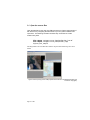
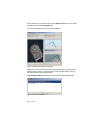
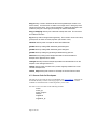
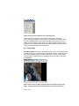
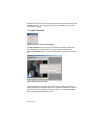
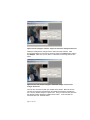
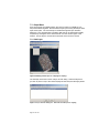
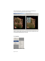
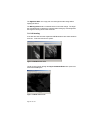
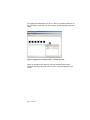
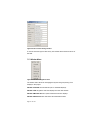
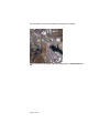
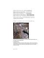
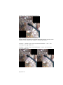
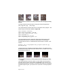
Figure 107 Shows a cut and resample differences. These are tiles cut at lat
37.92626 and lon –122.37761 with cut radius of 50 meters and gsd resolution of .5
meter. The original was a 5 meter image giving a 10x zoom. Left, is nearest
neighbor resampling, middle is cubic and the right side is sinc. See options table
for other resampler types
10.2.5Tiling
Orthoigen supports geographic, meters, and pixel tiling options. The tiling
specification is currently through an external keyword list and is loaded using the
–-tiling-template command option. The format of the template is:
igen.tiling.type: ossimTiling
igen.tiling.tiling_distance: 10000 10000
igen.tiling.tiling_distance_type: meters
igen.tiling.delta: 100 100
igen.tiling.delta_type: per_pixel
igen.tiling.tile_name_mask: tile_%r%_%c%
igen.tiling.padding_size_in_pixels: 0 0
where:
igen.tiling.tiling_distance specifies the unit of the distance type
igen.tiling.tiling_distance_type can be pixel, meters, degrees, minutes, or
seconds
igen.tiling.delta specifies the delta distance. If delta_type is per_pixel then it is
in the unit of the distance_type. If the delta_type is total pixels hen the delta is
the total number of pixels within the tiling_distance.
igen.tiling.delta_type can be total_pixels or per_pixel
igen.tiling.tile_name_mask specifes a mask for the filename. NOTE: this is
only used in igen application and not orthoigen. This mask is actually specified
Page 95 of 107