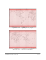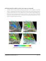
1
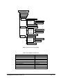
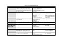
ASTER Reference Guide Version 1.0 March, 2003 ERSDAC Earth Remote Sensing Data Analysis Center Introduction High performance optical sensor, ASTER (Advanced Spaceborne Thermal Emission and Reflection Radiometer) was developed as a joint earth observation project between the U.S. and Japan, aiming at contributing to elucidate worldwide phenomena related to environment and to exploit natural resources. ASTER is mounted on Terra, the first spacecraft launched in December 1999 as part of EOS project, which is an international project headed by NASA. ASTER data has been distributed since December 2000, via ERSDAC (Earth Remote Sensing Data Analysis Center) in Japan. So far, ASTER has acquired no less than 500, 000 scenes, and the number is increasing steadily under satisfactory operation of the sensor. This “Reference Guide” was made for users to effectively take advantage of ASTER data. We, ERSDAC is delighted if the document proves helpful as a guidance in the process of research, order and processing of ASTER data for the use in various fields. ASTER Science Homepage: http://www.science.aster.ersdac.or.jp/en/index.html ASTER GDS Homepage: http://www.gds.aster.ersdac.or.jp/gds_www2002/index_e.html ASTER IMS Homepage: http://imsweb.aster.ersdac.or.jp/ims/html/MainMenu/MainMenu.html ASTER Reference Guide (Version 1.0) Page - i ASTER Reference Guide Table of Contents INTRODUCTION..................................................................................................................................I 1. BACKGROUND OF THE ASTER PROJECT................................................................................. 1 1.1 THE ASTER PROJECT .......................................................................................................................... 1 ■ Background of the ASTER Project ................................................................................................... 1 ■ ASTER observation objectives.......................................................................................................... 1 ■ ASTER’s development and operational structure........................................................................... 2 ■ ASTER Science Project ..................................................................................................................... 2 ■ ASTER Ground Data System (GDS)................................................................................................ 3 1.2 THE EOS PROJECT .............................................................................................................................. 5 ■ Background of the EOS Project........................................................................................................ 5 ■ EOS science objectives ...................................................................................................................... 5 ■ Sensors for the EOS Project ............................................................................................................. 6 2. WHAT IS ASTER DATA? ................................................................................................................. 7 2.1 OVERVIEW OF THE ASTER SENSOR ..................................................................................................... 7 ■ Terra’s orbit........................................................................................................................................ 7 ■ ASTER sensor.................................................................................................................................... 9 □ VNIR: Visible and Near-infrared Radiometer ........................................................................... 10 □ SWIR: Short Wave Infrared Radiometer ....................................................................................11 □ TIR: Thermal Infrared Radiometer.............................................................................................11 ■ ASTER observation mode ................................................................................................................11 2.2 EFFECTIVENESS OF ASTER DATA ..................................................................................................... 13 ■ Multi band data from visible to thermal infrared spectral region............................................... 13 ■ Stereoscopic data to be gained from singular orbit ...................................................................... 14 ■ Pointing function enables to observe the same area frequently .................................................. 15 2.3 ASTER PRODUCTS ............................................................................................................................. 16 ■ Standard products........................................................................................................................... 16 □ Level 1A........................................................................................................................................ 16 ASTER Reference Guide (Version 1.0) Page - ii □ Level 1B........................................................................................................................................ 16 □ Relative Spectral Emissivity (2A02) .......................................................................................... 16 □ Relative Spectral Reflectance (2A03) ......................................................................................... 17 □ Surface Radiance (2B01) ............................................................................................................. 17 □ Surface Reflectance (2B05) ......................................................................................................... 18 □ Surface Temperature (2B03)....................................................................................................... 18 □ Surface Emissivity (2B04) .......................................................................................................... 19 ■ Semi-Standard Product .................................................................................................................. 19 □ Orthographic Image (3A01) ........................................................................................................ 19 □ Digital Elevation Model –Relative- (4A01Z).............................................................................. 19 3. HOW TO OBTAIN ASTER DATA ...................................................................................................... 20 3.1 SERVICES FOR USERS.......................................................................................................................... 20 ■ User registration ............................................................................................................................. 20 □ Registration as a general user.................................................................................................... 20 □ Registration as an ARO (Announcement of Research Opportunity) user ............................... 21 ■ ASTER user services of ERSDAC .................................................................................................. 21 3.2 HOW TO OBTAIN AN ASTER DATA PRODUCT ....................................................................................... 23 ■ ASTER data products...................................................................................................................... 23 ■ Search and order of data................................................................................................................. 24 □ Search and order of data ............................................................................................................. 24 ■ How to generate DAR (Data Acquisition Request)?...................................................................... 26 3.3 NOTIFICATION FOR THE HANDLING OF ASTER DATA ......................................................................... 26 4. HOW TO USE ASTER DATA ............................................................................................................. 27 4.1 STRUCTURE OF ASTER DATA ............................................................................................................. 27 ■ Outline of Level-1B product ........................................................................................................... 27 ■ Product structure and volume of data ........................................................................................... 27 4.2 TO DISPLAY ASTER DATA ................................................................................................................... 29 ■ ASTER data format......................................................................................................................... 29 4.3 TO ANALYZE ASTER DATA .................................................................................................................. 31 ■ Format conversion of ASTER data using ASTER Data Opener .................................................. 31 ■ ASTER data analysis using MultiSpec.......................................................................................... 36 ASTER Reference Guide (Version 1.0) Page - iii 5. APPLICATIONS OF ASTER DATA ................................................................................................... 39 DATA ANALYSIS I : LAND COVER CLASSIFICATION MAP - INBANUMA MARSH IN CHIBA PREF......................40 DATA ANALYSIS II : SNOW COVER IN ANTI-DISASTER AREA OF DEBRIS AVALANCHE - MT. FUJI ...................41 DATA ANALYSIS III : HEAT EFFECT IN URBAN AREA - TOKYO BAY ..................................................................42 DATA ANALYSIS IV : WATER TURBIDITY - KASUMIGAURA IN IBARAKI PREF. .................................................43 DATA ANALYSIS V : EXTRACT BARE GROUND IN FOREST AREA - AREA SURROUNDING SAMEURA DAM IN KOCHI PREF. ...........................................................................................................................................................44 DATA ANALYSIS VI : SEASONAL CHANGES IN CANOPY RATIO - TAMA AREA IN TOKYO .................................45 DATA ANALYSIS VII : SULFUR DIOXIDE EMISSION - MIYAKEJIMA ISLAND .....................................................46 DATA ANALYSIS VIII : SUBMERGED AREA AFTER FLOOD STRIKE - ELBE RIVER BASIN IN CZECH ................. 47 APPENDICES APP. I REQUIREMENTS FOR ASTER DATA DISTRIBUTION ···································································II APP. II APPLOCATION FORM FOR ASTER GDS USER REGISTRATIONpplication ································VI APP.III ACRONYMS ·····································································································································VII ASTER Reference Guide (Version 1.0) Page - iv 1. Background of the ASTER Project 1.1 The ASTER Project ■ Background of the ASTER Project Japanese Ministry of Economy, Trade and Industry (METI) (formerly MITI, The Ministry of International Trading and Industry) launched Japanese Earth Resource Spacecraft (JERS-1) in 1992, with its primary purpose being to investigate the Earth’s resources. Users of JERS-1’s geological and natural resource remote sensing services have since called for METI to develop more advanced sensors than those of JERS-1 to obtain more detailed geological data and to gain insight into phenomena that have a significant impact on the global environment. In response to these demands, METI has developed ASTER (Advanced Spaceborne Thermal Emission and Reflection Radiometer). ASTER was placed on board of the first spacecraft of the EOS Project, Terra (EOS AM-1), launched in December 1999. Since then, the ASTER operation has been carried out successfully. ■ ASTER Observation Objectives The purpose of the ASTER Project is to deepen understanding of local and regional phenomena occurring on the surface of earth and in the atmosphere. The specific goals are as follows. 9 To promote research into geological phenomena of tectonic surfaces and geological history by means of detailed mapping of the Earth’s topography and geological formations. (This goal includes contributions to the applied research of remote sensing.) 9 To understand the distribution of vegetation and its changes. 9 To gain further understanding of interactions between the Earth’s surface and atmosphere by surface temperature mapping. 9 To evaluate the impact of volcanic gas emissions to the atmosphere through monitoring of volcanic activities. 9 To contribute to understand the characteristics of aerosols in the atmosphere and for cloud classification. 9 To contribute to understand the roles that coral reefs play in the carbon cycle through coral classification and to make global distribution mapping of corals. ASTER Reference Guide (Version 1.0) Page - 1 ■ ASTER’s Development and Operational Structure In the ASTER Project, the ASTER Science Team is organized, which is composed of Japanese and American researchers in wide spectrum of fields, including geology, geological resources, meteorology, agriculture and forestry, and environmental science. Since the ASTER Project is a part of the EOS Project, it is managed under close coordination between Japan and the United States. Japan takes the share of the responsibility for ASTER sensor development, generating optimal observation plans that accommodate and implement data acquisition requests from ASTER users, and data processing of raw data to generate it in the standard format (Level 1 processing), while the United States takes the share of the responsibility for providing the spacecraft, the launch vehicle and launch service, and up-link and down-link for commands and telemetry data. METI(Ministry of Economy, Trade and Industry) Manufacturing Industries Bureau Aerospace and Defense Industry Division JAROS (Japan Resources Observation System Organization) AIST (National Institute of Advanced Industrial Science and Technology) NASA ERSDAC (Earth Remote Sensing Data Analysis Center) ASTER Science Team (Team Leader) Committee of ASTER Sensor SOEC(Committee for Sensor Operation) ASTER Science Team (Japan) ASTER Science Team (U.S.) Fig. ASTER’s development and operational structure ■ ASTER Science Project ASTER Science Project is led by ASTER science team (team leader: Hiroji Tsu, ERSDAC), consisted of scientists in Japan and the U.S. ASTER science team consists of scientists whose studies range over multiple fields including geology, natural resources, meteorology, agriculture, forestry, oceanography and environment. The team promotes data application and provides instructions and advices in coordinating user requirements. ASTER ASTER Reference Guide (Version 1.0) Page - 2 Science Team is divided into multiple working groups (WG) separately in Japan and the U.S., where specific activities take place. Each WG works on different research theme, and the results will be reported at ASTER Science Team Meeting, in which adjustments between Japan and the U.S. sides are also made. Table: The WGs of the ASTER Science Project organized in Japan WG OMP WG Level – 1/ Geometric /DEM WG Radiometric Calibration WG Atmosphere & Atmospheric Correction WG TES WG HLDP WG Geology WG Oceanography/Ecosystem WG Chair Yasushi Yamaguchi, Nagoya University Hiroyuki Fujisada, Sensor Information Lab. Corp. Kohei Arai, Saga University Satoshi Tsuchida, Geological Survey of Japan, AIST Shuichi Rokugawa, University of Tokyo Isao Sato, Geological Survey of Japan, AIST Minoru Urai, Geological Surve of Japan, AIST Tsuneo Matsunaga, National Institute for Environment Studies Activity Establishment of data acquisition policy Development of L1 data processing algorithm Design of geometric verification plan Development of digital elevation model algorithm Designing of calibration plan for radiant quantities Development of atmospheric correction algorithm Development of derivation algorithm for emissivity and reflectance Development of derivation algorithms for surface temperature and emissivity Coordination of higher-level data products Development of ASTER Users’ Guide Development of Application algorithms in the geology field Development of a spectral database Development of application algorithms in the environmental field Development of application algorithms in the oceanography and limnology fields As of FY2003 ■ ASTER Ground Data System (GDS) The ASTER Ground Data System (ASTER GDS) is the ground system, which performs the ASTER mission operations and carries out data processing, archiving, distribution, etc., of ASTER data. ASTER GDS consists of three segments: AOS (ASTER Operation Segment) mainly performs the ASTER mission operation and monitors the status of the ASTER sensor; SDPS (Science Data Processing Segment) provides the interface and controls processing, analysis, archive and distribution; CSMS (Communication and System Management Segment) is responsible for networking and control of the two segments mentioned above. ASTER Reference Guide (Version 1.0) Page - 3 In addition, each segment is composed of several units (subsystems). This structure is almost identical to that of ECS (EOSDIS Core System) in EOSDIS, the ground system of the United States that corresponds to Japan’s ASTER GDS. Fig Overview of ASTER GDS ASTER Reference Guide (Version 1.0) Page - 4 1.2 The EOS Project ■ Background of the EOS Project In the early 21st century, Planet Earth will face global-scale environmental changes, such as global warming, rising sea levels, deforestation, desertification and ozone depletion—all of which gives a profoundly negative impact on the environment. However, we do not have sufficient information on these phenomena, particularly on climate change. To elucidate the mechanisms of climate change, the most serious of the above changes, NASA promotes the Earth Observing System Project (EOS Project) in which systems have been and will be developed for observing the Earth from space from satellites and of data processing and various research programs for data application. ■ EOS Science Objectives The EOS science objectives are as follows: Water and Energy Cycles Cloud formation, dissipation, and radiative properties, which influence response of the atmosphere to greenhouse forcing. Large-scaled hydrology and moisture process cycles, including precipitation and evaporation. Oceans Exchange of energy, water, and chemicals between the ocean and atmosphere, and between the upper layers of the ocean and deep ocean (includes sea ice and formation of bottom water). Science of the Troposphere and Lower Stratosphere Links to the hydrologic cycle and ecosystems, transformations of greenhouse gases in the atmosphere, and interactions inducing climate change. Land, Surface Hydrology and Ecosystem Processes Improved estimates of runoff over the land surface and into the oceans. Sources and sinks of greenhouse gases. Exchange of moisture and energy between the land surface and atmosphere. Observe changes in land cover Glaciers and Polar Ice Sheets Predictions of sea level and global water balance. Chemistry of the Middle and Upper Stratosphere Chemical reactions, solar-atmosphere relations, and sources and sinks of radiatively important gases. Solid Earth Volcanoes and their role in climatic change. ASTER Reference Guide (Version 1.0) Page - 5 ■ Sensors for the EOS Project Among 24 sensors planned to be installed in instruments for use in the EOS Project, ASTER (Advanced Spaceborne Thermal Emission and Reflection Radiometer), MODIS (Moderate-Resolution Imaging Spectroradiometer), MOPITT (Measurements Of Pollution In the Troposphere), MISR (Multi-angle Imaging Spectroradiometer) and CERES (Clouds and the Earth’s Radiant Energy System) are loaded onto the Terra platform, the first satellite launched as part of the Project. For further information on observation sensors planned under EOS Project and sensors on Terra, please visit the following website: ASTER Reference Guide (Version 1.0) EOS Project Homepage: http://eospso.gsfc.nasa.gov/ Terra Homepage: http://terra.nasa.gov/ Page - 6 2. What is ASTER Data? 2.1 Overview of the ASTER Sensor ■ Terra’s orbit Terra (formerly EOS AM-1), on which ASTER is carried, is the initiating spacecraft of the EOS Project and was launched on 18 December 1999 from Vandenberg Air Force Base in the US. ASTER data collection started on 24th Feb. 2000 and made public from 1st Dec. 2000. Planned lifetime of Terra is 6 years and the observation will continue until 2005. Terra revolves around sun-synchronous orbit on 16-day cycle (returns to the original orbit in 16 days), passing over equator at around 10:30 at the local time. The altitude is about 705km just over equator and circles around the earth in every 98.9 minutes. Therefore, Terra revolves 233 orbit paths in every 16 days. Landsat-7 operates on the same orbit, 30 minutes ahead of Terra. Terra’s orbit parameters are shown in table below: Table: Terra orbit parameters Orbit Pass time over equator Altitude Orbit inclination Repeat cycle Inter-orbit distance Revolution time Orbit positioning accuracy Repetition accuracy Sun-Synchronous Descending 10:30 +/- 15 min (AM) at local time 700 – 737 km (705km on the equator) 98.2deg. +/- 0.15deg. 16 days (233 revolutions / 16 days) 172km on the equator 98.9 minutes +/-150 meter / 3 axis, 3σ +/-20 km, 3σ Path Map of Terra is as shown below: ASTER Reference Guide (Version 1.0) Page - 7 Fig Path Map of Terra – Long. 180deg. W to Long. 60deg. E Fig Path Map of Terra – Long. 30deg. W to Long. 180deg. E ASTER Reference Guide (Version 1.0) Page - 8 ■ ASTER sensor ASTER is a high performance optical sensor with 14 spectral bands that range from visible to thermal infrared bands. ASTER provides valuable scientific and practical data of the Earth in various fields of research. ASTER is comprised of the following three radiometers: Visible and Near Infrared Radiometer (VNIR) Wavelength: 0.56-0.86µm Short Wavelength Infrared Radiometer (SWIR) Wavelength: 1.60-2.43µm Thermal Infrared Radiometer (TIR) Wavelength: 8.125-11.65µm The ASTER sensor is characterized by: 9 Providing image data of the Earth from visible to thermal infrared wavelengths 9 Realizing unprecedented geometric high resolution and radiance in each of its various bands. 9 Acquiring stereoscopic data in single orbit using the near-infrared band. 9 Employing a pointing function of ± 8.55 degrees for SWIR and TIR, and ± 24 degrees for VNIR, perpendicular to along track direction. 9 Being equipped with a highly reliable cooling machine for SWIR and TIR. (Designed lifetime is 50,000 hours) 9 Satisfying the needs of businesses and scientists engaged in natural resource exploration and environmental monitoring. Major characteristics of ASTER sensor is as follows; ASTER Reference Guide (Version 1.0) Page - 9 Table Major characteristics of ASTER sensor Radiometer VNIR SWIR TIR Band 1 2 3N 3B 4 5 6 7 8 9 10 11 12 13 14 Wavelength (µm) 0.52 - 0.60 0.63 - 0.69 0.78 - 0.86 0.78 - 0.86 1.600 - 1.700 2.145 - 2.185 2.185 - 2.225 2.235 - 2.285 2.295 - 2.365 2.360 - 2.430 8.125 - 8.475 8.475 - 8.825 8.925 - 9.275 10.25 - 10.95 10.95 - 11.65 Spatial resolution Quantum number 15 m 8 bits 30 m 8 bits 90 m 12 bits □ VNIR: Visible and Near-infrared Radiometer This is a high-performance, high-resolution optical instrument, which detects reflection from the ground surface ranging from visible to near-infrared levels and produce multi-spectrum images. The fourth band (3B) has backward-looking optical system of 27.6 degree from nadir and a detector, which enable stereoscopic images to be generated in a single orbit by combining the same wavelength nadir band. The radiometer is corrected in orbit by using a halogen lamp, which promises high radiometric performance. It also employs a vertical pointing function of +/-24 degrees, which makes it possible to repeat observation of the same area within 5 days. ASTER Reference Guide (Version 1.0) Page - 10 □ SWIR: Short Wave Infrared Radiometer This is a high-resolution optical instrument that detects reflection from the ground surface within the short-wavelength infrared range of 1.60 – 2.43 µm. The radiometer employs a vertical pointing function of +/-8.55 degrees. □ TIR: Thermal Infrared Radiometer This is a high-accuracy instrument, which carries out observations of thermal infrared (8 – 12 µm) from the ground surface in five bands. The radiometer is designed to identify mineral resources and observe atmospheric, ground surface and sea surface conditions by taking advantage of their thermal infrared characteristics. The radiometer employs a vertical pointing function of up to +/-8.55 degrees. ■ ASTER observation mode ASTER has several observation modes to correspond to different subjects of observation as well as purposes of application (see Table below). It is, therefore, necessary to select an observation mode matched to your study objective. Basic observation modes are Full Mode for day observation, which obtains data with all bands, and TIR Only Mode at night. Other than these, VNIR Only Mode and TIR Only Mode are available for day observation. Meanwhile, SWIR+TIR Mode available for night observation enables to observe active volcanic lava and other high temperature areas. However, day observation can also obtain stereoscopic ASTER Reference Guide (Version 1.0) Page - 11 data with Full Mode and VNIR Mode observing both nadir-looking band 3N and backward-looking band 3B. Table: ASTER observation mode Observation mode Full Mode VNIR Mode TIR Mode Nighttime TIR Mode SWIR + TIR Mode Obs. Daytime Obs. VNIR * * Radiometer SWIR * TIR * Data rate * * * * 89.2 Mbps 62.038 Mbps 4.109 Mbps 4.109 Mbps 27.162 Mbps Note: stereo data of 3N and 3B data will be acquired under Full Mode and VNIR Mode In light of diversity in observation objectives, VNIR and SWIR are equipped with gain switch function, which can be set for individual bands to allow for adjustment for each objective. Band 1 and 2 are set high gain and the other bands normal gain as the standard setting. However, in high reflectance area such as desert and snow or ice covered areas, low gain is applied, while low reflectance area such as sea is set high gain, on a case by case basis. Low gain2 equipped with SWIR is aimed at observation of high temperature objectives such as volcanic lava. Please refer to “ASTER User’s Guide” for the details of gain setting of each band and the sensitivities. ASTER Reference Guide (Version 1.0) Page - 12 2.2 Effectiveness of ASTER Data ASTER realized to obtain earth observation data of unprecedented nature. The most effective three features in data application are introduced in this section. ■ Multi band data from visible to thermal infrared spectral region ASTER has 14 bands from visible to thermal infrared region, which enables to provide more information than that provided by Landsat/TM, ETM+, a representative earth observation sensor. More specifically, Landsat/TM, ETM+ has 2 bands in short wave infrared region (SWIR), whereas ASTER has 6 bands in the region. Thanks to this, ASTER data is applicable to define minerals and rocks in resource exploration, environmental monitoring such as vegetation, monitoring of volcanic activity and others. In thermal infrared region (TIR), Landsat/TM, ETM+ has only one band, while ASTER has 5 bands. This is why ASTER is expected to contribute greatly in fields, which require highly accurate temperature and emissivity detection such as identification of ores (felsite from mafic rock), studies on cloud, evapotranspiration, heat island effect in urban areas, monitoring of volcanic activity, heated effluent and others. Comparison of ASTER with other earth observation sensors and the absorption zone of minerals in each wavelength region are shown in the following figure. band 1, 2, 3 band 4 band 5, 6, 7, 8, 9 band 10∼14 quartzite COSMIC GAMMA RAY RAY ULTRAVIOLET X RAY chlorite MICRO SHORT MIDDLE LONG WAVE WAVE WAVE WAVE INFRARED VISIBLE epidote INFRARED hematite 0.40 LANDSAT-4,5 (TM) 0.50 0.60 1 0.70 2 0.80 3 4 5 7 6 jarosite kaolinite monzonite trachyandesite Periotite basalt muscovite SPOT-1,2,3 (HRV) 1 2 3 JERS-1 (OPS) 1 montmorillonite 2 .60 .52 1 .63 .76 .86 1.6 1.71 2.02 2.43 8.0 11.65 Basic rock montmorillonite Limestone(clay/quartz) limonite 3,4 .69 2 kaolinite goesite PANCROMATIC MODE Terra (ASTER) calcite 13.5 Quartz-monzonite allunite 3 limestone dolomite Spectral Coverage of Optical Sensors wavelength(μm) Figure: Features of ASTER bands ASTER Reference Guide (Version 1.0) Page - 13 ■ Stereoscopic data to be gained from singular orbit Another pronounced feature of ASTER is the capability to collect information, which leads to the production of stereoscopic data by combining them with high spatial resolution spectral information. ASTER band3 in VNIR (0.78 – 0.86µm) can observe nadir-looking (3N) and backward looking (3B) data simultaneously. Stereoscopic data can be produced by the combination of these data. Also, based on the stereoscopic data, digital elevation model (DEM) can be processed. In this way, ASTER data can add three-dimensional information on topographic map. Accuracy of DEM data could vary in areas but the maximum error on ground surface is up to 50m and the maximum elevation error is up to 15m. The following image shows an example of bird’s eye view image processed based on ASTER DEM data. VNIR Image DEM Image Bird’s eye view of Pinatubo volcano (Processed from ASTER/VNIR and DEM data) ASTER Reference Guide (Version 1.0) Page - 14 ■ Pointing function enables to observe the same area frequently ASTER visible/near infrared radiometer (VNIR) has pointing function of up to 24degrees in cross track direction. This pointing function enables to observe the same area in every 3-5 days, making it possible to respond to emergent observations. So far, ASTER observed volcanic eruptions in Miyake Island and Usu Mountain in response to domestic emergency observation requests. Some of the images are exhibited at image gallery in ASTER GDS Homepage. Water temperature monitoring in Kasumigaura area is shown below as an example of frequent observation. 5C 15C Figure Water temperature monitoring in Kasumigaura ASTER Reference Guide (Version 1.0) Page - 15 2.3 ASTER Products ASTER data available at ERSDAC can be divided into “Standard Products” and “Semi-Standard Products”. Features of various products included in the two categories are shown below with sample images. ■ Standard Products □ Level 1A This product is generated from L0 data by applying parallax correction, Geometric correction coefficient and radiometric coefficient are attached but the corrections are not reflected to the data. Accordingly, the image does not completely correspond to the map of any projection. □ Level 1B This product is generated from L1A data by reflecting attached geometric correction and radiometric correction coefficients. The data corresponds to the map of the same projection method. Also, values (DN) of the image data are possible to be converted into physical values such as radiance and temperature □ Relative Spectral Emissivity (2A02) This product is generated from data acquired by TIR (Thermal Infrared Radiometer) applying decorrelation stretch. So, subtle difference of radiation, which is usually the case with thermal infrared data, is emphasized in the product to enhance spectral effect. The product serves as an effective aid for selecting ASTER scenes to be applied to detailed analysis. Noises would be emphasized when the process is applied to the scene with small spectral differences. ASTER Reference Guide (Version 1.0) Page - 16 □ Relative Spectral Reflectance (2A03) - VNIR (2A03V) The product is produced by rendering decorrelation stretch processing to VNIR (Visible and Near-infrared Radiometer) data, in order to emphasize reflectance difference. The product serves as an effective aid for selecting ASTER scenes to be applied to detailed analysis. Especially helpful for users who analyze data with greater spectral variations. Noises appear in the image when the process is applied to data with small spectral differences. - SWIR (2A03S) The product is produced by rendering decorrelation stretch processing to SWIR (Short Wave Infrared Radiometer) data, in order to emphasize reflectance difference. The product serves as an effective assistance for selecting ASTER scenes to be applied to detailed analysis. It is especially helpful for users who analyze data with greater spectral variations. Noises appear in the image when the process is applied to data with small spectral differences. □ Surface Radiance (2B01) - VNIR (2B01V) The product is produced by rendering atmospheric correction to VNIR data. - SWIR (2B01S) The product is produced by rendering atmospheric correction to SWIR data. ASTER Reference Guide (Version 1.0) Page - 17 - TIR (2B01T) The product is produced by rendering atmospheric correction to TIR data. □ Surface Reflectance (2B05) - VNIR (2B05V) The product is produced by converting atmospheric corrected VNIR data to reflectance. - SWIR (2B05S) The product is produced by converting atmospheric corrected SWIR data to reflectance. □ Surface Temperature (2B03) The product is produced by rendering temperature-emissivity separation processing to atmospheric corrected surface radiance (2B01T), data of five bands of TIR. ASTER Reference Guide (Version 1.0) Page - 18 □ Surface Emissivity (2B04) The product is produced by rendering temperature-emissivity separation processing to atmospheric corrected surface radiance (2B01T), data of five bands of TIR. ■ Semi-Standard Product □ Orthographic Image (3A01) The product is made by correcting the original image to be orthogonal projection to eliminate topographical distortion. The distortion is corrected based on relative Digital Elevation Model XYZ (4A01X) products. The product is produced based on level1A product including band 3N and 3B, and relative DEM-XYZ (4A01X) product and rendered SWIR high accuracy parallax correction. The data accompanies the DEM data. □ Digital Elevation Model –Relative- (4A01Z) The product is an elevation data set extracted based on 3D data acquired by band 3N (nadir-looking) and 3B (backward-looking) of VNIR. The product is not subject to corrections for absolute location, altitude and others to be carried out using GCP. ASTER Reference Guide (Version 1.0) Page - 19 3. How to Obtain ASTER Data 3.1 Services for Users ERSDAC provides most of its services through web based ASTER GDS, allowing for users from data search to the acquisition on their PC. Please refer to the following details of user registration process and outline of user services. ■ User registration In order to receive products, and services for processing and distribution, you need to be registered as a user trough ASTER GDS. There are two kinds of user categories for registration, with different services available. Please refer to the following table and choose either one that meets your needs (please note that you can search ASTER data without making registration). User category General User ARO (Announcement of Research Opportunity) User Available services Processing and distribution services of products archived at ASTER GDS In addition to the same services available to general users, ARO users can submit data acquisition requests (DAR) □ Registration as a general user Read thoroughly “Requirements for ASTER data distribution” (appended at the end of the document) that specify all restrictions and regulations related to ASTER data distribution. Fill out the “Application Form for ASTER Data User Registration” attached at the end of the document. Sign and send it to the ASTER GDS whose postal address is shown below. Upon receipt of the application form, ASTER GDS will register the applicant as an ASTER GDS User. When the registration completes, ASTER GDS will return “Notification of ASTER Data User Registration” with user ID, login name and temporary password, necessary to receive available services, to the user by post. Contact Point: ASTER user service, ERSDAC FOREFRONT TOWER 5F, 3-12-1 KACHIDOKI, CHUO-KU TOKYO 104-0054, JAPAN E-mail : [email protected] Tel: 03-3533-9388 Fax: 03-3533-9390 ASTER Reference Guide (Version 1.0) Page - 20 □ Registration as an ARO (Announcement of Research Opportunity) user To be registered as an ARO User, application should be made through ASTER Science Project Homepage (http://www.science.aster.ersdac.or.jp/en/index.html). Submission of ARO research proposal is possible through the Homepage. Making data acquisition request of up to 40,000km2 (corresponds to about 12 ASTER scenes) becomes eligible if the proposal is accepted. ARO user can receive the acquired data free of charge. For any questions or details, please contact ARO Office below: *Solicitation for ASTER ARO application will be terminated as of 29th February 2004. Contact point: ASTER ARO OFFICE, ERSDAC FOREFRONT TOWER 14F, 3-12-1 KACHIDOKI, CHUO-KU TOKYO 104-0054, JAPAN E-mail : [email protected] Tel: 03-3533-9310 Fax: 03-3533-9383 ■ ASTER user services of ERSDAC ASTER GDS offers various user services through the following “ASTER GDS IMS” website. http://imsweb.aster.ersdac.or.jp/ims/html/MainMenu/MainMenu.html “ASTER Information” provides the following ASTER GDS-related information. ASTER Reference Guide (Version 1.0) Page - 21 Table: Menu of ASTER user services EDS Completion Indicates EDS(transmission of level 0 data from the U.S. via network circuit) processing and the product production are completed. Information Product Map ASTER Information The map is provided as a bitmap to indicate the areas where ASTER has acquired data. Orbit Projection The orbit projection of the TERRA satellite is shown on a map. Electronic Bulletin Board Information exchange among registered Users is enabled on the electronic bulletin board. (This service is only available for ASTER GDS-registered Users who have been provided with a Login Name and Password. Please refer to “User Registration” for how to become an ASTER GDS User. User Registration /Modification Service This service helps Users to register with ASTER GDS, or to modify or cancel their user registration information. Users who wish to receive the Product Processing and Distribution Service are required to apply for User Registration. Printable forms are available either on the ASTER-GDS Homepage or from the ASTER GDS User Service. You can also change your Password or other registration information through this service. Products Search Service This service enables Users to make searches for ASTER Data Products archived in the ASTER GDS. This service can be utilized to check product availability, or to confirm each product by checking the Browse Data, Coverage Map and so on. (This service is also open to non-registered users) Product Processing and Distribution Service This service enables Users to search for ASTER Data Product(s) and to request their delivery. It also enables Users to make a request for processing of the original data to a higher level. (This service is only available for ASTER GDS registered Users.) Data Acquisition Request Service This service enables a User to acquire ASTER observation data under specified conditions of time, region, and environment by Users. (Non-registered users and General Users do not have the right to utilize this service.) You can request an acquisition by generating a Data Acquisition Request (DAR). GDS will add the User’s DAR to the ASTER observation schedule, and will process the data when acquired. However, delivery of the product(s) to the requester is not automated. Please generate a Data Production Request (DPR) using the Product Processing and Distribution Service, or, alternatively, request “DPR Link” at the time of generating your DAR. Please read carefully the “Directions on the use of ASTER Data” beforehand. Service available for General Users Service available for ARO Users ASTER Reference Guide (Version 1.0) Page - 22 3.2 How to obtain an ASTER data product This section explains how to search and obtain ASTER data products after completion of registration as a user. ■ ASTER data products ASTER data products listed below are available at ERSDAC. (Please refer to section 2.3 for detailed explanation of each product.) Table: List of ASTER data products Product name Level-1A Level-1B Relative emissivity (2A02) Relative reflectance (V) (2A03) Relative reflectance (S) (2A03S) Surface radiance (V) (2B01V) Standard Surface radiance (S) (2B01S) Surface radiance (T) (2B01T) Surface reflectance (V) (2B05V) Surface reflectance (S) (2B05S) Surface temperature (2B03) Surface emissivity (2B04) Ortho image (3A01) Semi Standard Relative DEM Z(4A01Z) Resolution (m) V(15), S (30), T (90) V(15), S (30), T (90) 90 15 30 15 30 90 15 30 T(90) T(90) V(15), S (30), T (90) Open date Dec. 2000 Dec. 2000 Aug. 2002 Aug. 2002 Aug. 2002 Nov. 2002 Nov. 2002 Nov. 2002 Nov. 2002 Nov. 2002 Jun. 2003 Jun. 2003 Aug. 2002 V(15), S (30), T (90) Aug. 2002 V:VNIR , S: SWIR , T: TIR # For charges to purchase the above product, please visit ASTER GDS homepage (http://www.gds.aster.ersdac.or.jp/gds_www2002/index_e.html). # Cost for delivery and the media (CD-ROM) is included in the charge. For the settlement of the charge (advance payment), credit card (DC, JCB, MasterCard and VISA) is available in addition to bank transfer to the designated bank by ERSDAC. ASTER Reference Guide (Version 1.0) Page - 23 ■ Search and order of data For the search and order of ASTER data, ASTER GDS-IMS is available, where you can point out location of the interested area on a map or specify it by entering latitude and longitude. Please refer to the procedure detailed as follows: □ Search and order of data ASTER GDS-IMS is available for the search and order of ASTER data. Please visit the following website ASTER GDS-IMS Homepage: http://imsweb.aster.ersdac.or.jp/ims/html/MainMenu/MainMenu_j.html Please follow the procedure as follows for the search and order of ASTER data ASTER Reference Guide (Version 1.0) Page - 24 Selection of DPR (Data Processing Request) menu - Select “User Certification” on the top page to enter login name and password. ¾ If you want to search the data and not order, the certification is not necessary. - Select “DPR (Data Processing Request)” from the top page and then select “DPR Search” from DPR Menu window. Enter conditions for search - From Product Search window, specify conditions such as “Instrument Mode”, “Processing Level”, “Cloud Coverage” and “Continuous Time Range”. - Generally, “Inventory” should be selected for “Search Type”. - After specifying the conditions, click on “Search Area” tug on upper left. Input of Search Area - Either by entering latitude and longitude or clicking on a map, you can specify desired area. - There are two options, “Rectangle” and “Four Corners”, from which you can input latitude and longitude of search areas. - You can also easily point out an area on a map using “Click & Drag to Zoom In” function. After pressing “Click & Drag to Zoom In” button on upper right of a map, click and drag on a map of your search area so that you can zoom in to exactly specify smaller area. - After specifying your search area, click on “Search Exec.” at the upper right to start search. ASTER Reference Guide (Version 1.0) Page - 25 DPR Inventory Search Result - On completion of product search, a window showing search result appears. - List of product appears according to the product levels. - Select your wanted granule based on “Inventory Detailed Info.”, “Coverage Map”, “Browse” and “Metadata” and click “Select Granule” below per each granule. - In case higher-level product of your wanted data is not produced, select “Level 1A” and request product generation in the next window. - Confirm that all the wanted granule IDs are selected and click “Product Order” below. Product Estimate/Order - Confirm all of the granule IDs you want are selected. - When making a request of processing higher-level product, select granule ID to process and click on “PG Parameter”. - Click on “Media & Format Select” to select media for distribution and data format. - Media and format will be the same for all the data ordered under one DPR. - In case of payment by credit card, please select “Credit Card” as a payment option. - Confirm the contents of your request and click on “Submit DPR Request” to complete generation of an order. - In case of payment by credit card, identification screen appears and an order will be generated on completion of transmit and receipt of the card information. ■ How to generate DAR (Data Acquisition Request)? Right to generate ASTER Data Acquisition Request is granted sorely to ARO (Announcement of Research Opportunities) researchers. Please refer to “Services for Users” in section 3.1 for the details to be an ARO user. 3.3 Notification for the Handling of ASTER Data Please read “Requirements for ASTER data distribution” attached at the end of this Reference Guide for the handling of ASTER data. Please contact ASTER User Service in ERSDAC for any questions and comments. ASTER Reference Guide (Version 1.0) Page - 26 4. How to Use ASTER Data 4.1 Structure of ASTER Data In this section, explain the structure of ASTER data based on Level-1B data, which is the most popular ASTER product. Please refer to “ASTER User’s Guide” for the details of each product and coefficient used for the generation of products. ■ Outline of Level-1B product Level-1B is produced out of Level-1A by applying radiometric correction coefficient and geometric correction coefficient. L1B is processed according to map projection (“UTM” (standard), “Lambert Conformal Conic”, “Polar Stereographic”, “Uniform Lat, Long” or “SOM”) and resampling method (“Cubic Convolution”(standard), “Nearest Neighbor” or “Bi-linear”) requested by user. The data is observed in a so-called “Path Oriented” manner, which means data is observed along satellite direction. Actual pixel size is slightly dependent on altitude and pointing angle of the satellite. However, pixel size of the product is adjusted to be 15m for VNIR, 30m for SWIR and 90m for TIR regardless of conditions at data acquisition. ■ Product structure and volume of data Product structure and volume of data for L1B is as shown below. All the images and metadata of ASTER product is stored in a single HDF-EOS file (product in CEOS format is also available). By applying software (refer to section 4.2), which enables to handle HDF-EOS file, there is no need for users to worry about the data volume of each file comprising product, or the order of storing files when handling images. ASTER Reference Guide (Version 1.0) Page - 27 Lev el-1 B D ata Pro du ct Data D irectory Gen eric Head er An cillary D ata VN IR D ata VN IR Sp ecific Head er VN IR VN IR VN IR VN IR Ban d 1 Ban d 2 Ban d 3 N Ban d 3 B Geo lo cation Field Data VN IR Imag e Data VN IR Su pp lemen t D ata SWIR Data SWIR Specific H eader SWIR SWIR SWIR SWIR SWIR SWIR Band Band Band Band Band Band 4 5 6 7 8 9 Geo lo cation Field Data SWIR Image D ata SWIR Sup plement Data TIR Data TIR Specific H eader TIR TIR TIR TIR TIR Band Band Band Band Band 10 11 12 13 14 Geo lo cation Field Data TIR Image D ata TIR Sup plement Data Figure: Structure of Level-1B data. Table: Level-1B Data Product Size Item Data size (byte) Data Directory Generic Header Specific Header Ancillary Data Supplement Data VNIR Image Data SWIR Image Data TIR Image Data Geolocation Data Field Total 8,192 about 4,000 about 9,100 about 1,728 about 1,379,550 85,656,000 31,794,000 5,810,000 TBD about 125 MB ASTER Reference Guide (Version 1.0) Page - 28 4.2 To Display ASTER Data ■ ASTER data format As aforementioned, ASTER products are in HDF-EOS format. The HDF (Hierarchical Data Format) was developed by National Center for Supercomputing Applications (NCSA) at Illinois State University, and this format enables to handle science data in various formats. HDF-EOS features an upgraded HDF function to increase efficiency in visualizing EOS data, also supplemented with the EOSDIS Core System (ECS) rules, data type and metadata. With the geographic data (point, grid and swath data) also supplemented in the format, required data can be searched based on the position and time on earth. Strictly speaking, EOS View provided by NASA is the only display software for HDF-EOS. However, Illinois University, a home to NCSA, JPL (Jet Propulsion Laboratory), which undertakes development of earth observation equipment and study of earth observation data and a private company, Fortner provide their own software for HDF display and related utilities. ERSDAC offers “ASTER Data Opener”, a tool used to convert ASTER data in HDF format into single band or BSQ format, as well as information about available HDF display software and related utilities. Please visit the following website for the details to acquire “ASTER Data Opener” (ERSDAC©) and other tools. http://www.gds.aster.ersdac.or.jp/gds_www2002/service_e/u.tools_e/set_u.tool_e.html Available HDF display tool and related utilities are introduced in the following table. ASTER Reference Guide (Version 1.0) Page - 29 Table: List of available HDF display tool Name of software EOS View PV-WAVE Outline A tool for displaying, inspecting and verifying HDF-EOS files. Does not have image analysis function. It easily displays grid, point and swath structures, even without information on a file structure. The latest version is 2.2 (already verified), but 2.3β is also available. Visual Numerics offers a one-month trial prior to purchase. ENVISION Free software developed by the Department of Atmospheric Sciences, University of Illinois at Urbana-Champaign Linked Windows Interactive Data System(LinkWinds) NCSA Java HDF Interface (JHI) and Java HDF Viewer(JHV) Imagery data display software developed by NASA/JPL HDF Browser Provided by Fortner for free ASTER Data Opener Tool to convert ASTER data in HDF format into single band or BSQ format. The tool enables to view ASTER data on commercial program such as Photoshop that can accommodate BSQ format data. Multi-purpose image processing free software. It is convenient in displaying HDF image file. MultiSpec Free software developed by NCSA. Compatible OS DEC Alpha Digital Unix 4.0 HP 9000/735 HP-UX A.10.01 IBM RS-6000 AIX 4.2 Sun Sparc Solaris 2.5.1 SGI Power Challenge IRIX 6.2 (32 and 64 bit mode) Intel PC Windows NT/2000/95/98 Intel PC Red Hat Linux 6.0 Digital Equipment Digital UNIX 4.0 Hewlett Packard HP-UX 10.2/11.0 IBM AIX 4.3 SGI IRIX6.5 SUN Microsystems Solaris 2.6 IBM RS6000 AIX 3.2.5 HP 700 HP/UX 9.0 Sun Sparc SunOS 4.1.3 SGI IRIX 5.2 DEC Alpha OSF 2.0 Can be used with SGI, Sun, IBM, HP and PC-based Linux workstations. Download from http://www.fortner.com/ UNIX Solaris Solaris-x86 SGI IRIX 5.3 and 6.2 Intel PC Windows 95/NT Intel PC Windows NT/95 Macintosh OS 7.1 or later Windows98SE/Me/NT (4.0 or later) /2000 http://hdf.ncsa.uiuc.edu/ java-hdf-html/ Macintosh OSX 10.1x and Mac OS9.* or former Windows95/98/ME/NT/2000/XP http://dynamo.ecn.purdue. Edu/~biehl/MultiSpec/ http://www.vni.com/produ cts/wave/wave7download. html (It is needed to obtain a license number via email or phone call in order to install free software from Visual Numerics) http://www.atmos.uiuc.ed u/e http://linkwinds.jpl.nasa. gov/ http://www.fortner.com/ http://www.gds.aster.ersd ac.or.jp/gds_www2002/Op ener/ASTERDataOpener.Izh 4.3 To Analyze ASTER Data In this section, we will explain procedures for the format conversion of ASTER data using ASTER Data Opener (ERSDAC©) and introduce a freeware for satellite data processing, called MultiSpec (Purdue University©), which enables to display image from HDF-EOS format. ■ Format conversion of ASTER data using “ASTER Data Opener” ASTER Data Opener is a tool to convert HDF-EOS format into BSQ format. BSQ format image is possible to be read, edited and saved on the general purpose image processing software represented by Photoshop. Please access the following Internet site to download ASTER Data Opener: http://www.gds.aster.ersdac.or.jp/gds_www2002/Opener/ASTERDataOpener.lzh Since the file is a compressed LZH form, please uncompress it using appropriate software for the purpose. After installation, you will be able to open the attached “ASTERDataer(e)0801_tif.pdf”. [Activating ASTER Data Opener] After inserting CD-ROM of ASTER products into a computer, please activate ASTERDataOpener.exe. Then, click on “REF” button when window of ASTER data specification appears. Back ASTER Reference Guide (Version 1.0) Next Cancel Help Page - 31 Next, select a folder that ASTER data file is contained. Select the type of file “pr*.dat” (HDF file) and click on “Open”. File name Open Files of type Cancel [Select a file to input] A window with file overview appears. You can check details of the file from “Details” button. Click on “next” to proceed. [Setup of output file] A window to set up output file appears. By clicking on “REF”, a window for saving the file appears. After designating the location and the file name, click on “Save” button. ASTER Reference Guide (Version 1.0) Page - 32 When the window for output file reappears, confirm the file name with extension added at the end automatically and click on “Next” button. [Select a sensor] A window for selecting bands for each sensor (VNIR, SWIR and TIR) appears. Click to check on the blank box at the left of the desired sensor(s) and “Save as separate BSQ file for each telescope”. (Checked on all of the three sensors as the default value for BSQ conversion) ASTER Reference Guide (Version 1.0) Page - 33 In case of Photoshop, the colors red, green and blue are allocated to bands with the number 1, 2 and 3 respectively. The number can be specified by user for desired bands. Please leave a note which color is allocated to what band so that you can trace afterwards. For example: If you select no. 1 for SWIR band 9, red will be allocated to the band in the image. If you select no. 2 for SWIR band 5, green will be allocated to the band in the image. If you select no. 4 for SWIR band 4, blue will be allocated to the band in the image. Click on “next” to execute BSQ conversion. [Confirmation of BSQ file] Details of BSQ converted file appear on a screen. Please take a copy of image size of each band per a sensor, because it becomes necessary when displaying the image using image processing software (e.g. size of VNIR Band 3N is 4980, 4200) (it is recommended to save the file information as an electronic file or print it out). ASTER Reference Guide (Version 1.0) Page - 34 Click on “completed” and then on “cancellation” to close ASTER Data Opener. ASTER Reference Guide (Version 1.0) Page - 35 ■ ASTER data analysis using “MultiSpec” MultiSpec is superb satellite image analysis software, developed by Purdue University in Indiana, the US, with the support of NASA and NSF. The software makes it possible to display and process ASTER data in HDF-EOS format and other various satellite data. The software, designed for either Windows or Macintosh, is available from the following website for free on making registration as a user. Manual (in English) with specific guidance for various satellite image analyses is also available from the site. For downloading MultiSpec, please visit: http://www.ece.purdue.edu/~biehl/MultiSpec/ The procedure of displaying ASTER image on MultiSpec is as follows: Multispec enables to read HDF-EOS format and display ASTER data without using format conversion tool. Select Open Image from File folder in the Menu of MultiSpec. Please select a folder with ASTER data file from the pop up window. Make sure that file type is designated at “All Files(*.*)” to display all the files. Then click “Open”. File name Open Files of type Cancel Set up screen for file format parameter appears. Select one band from “HDF Data Set” for display. Please note that only one band can be open at one time. Then, click on “OK”. ASTER Reference Guide (Version 1.0) Page - 36 When window for display specification appears, select stretch method for the image. Basically, there is no need to change the initial setting (linear stretch). ASTER Reference Guide (Version 1.0) Click on “OK” and the image will be displayed. Page - 37 In case of displaying an image of two or more bands, check on “Link to active image window” on left side of a window pop up from Open Image in File folder and select bands (do not forget to cancel the link afterwards). Then, select Display Image from Processor and allocate each band to colors Red, Green and Blue. When window for setting display appears, click on “OK “to display the image in the designated three colors. ASTER Reference Guide (Version 1.0) Page - 38 5. Applications of ASTER Data Data Analysis I ¾ Land Cover Classification Map – Inbanuma marsh in Chiba pref. Japan Data Analysis II ¾ Snow Cover in Anti-Disaster Area of Debris Avalanche – Mt. Fuji in Japan Data Analysis III ¾ Heat Effect in Urban Area – Tokyo Bay in Japan Data Analysis IV ¾ Water Turbidity – Kasumigaura in Ibaraki pref. Japan Data Analysis V ¾ Extract Bare Ground in Forest Area – Area surrounding Sameura dam in Kochi pref. Japan Data Analysis VI ¾ Seasonal Changes in Canopy Ratio – Tama area in Tokyo Japan Data Analysis VII ¾ Sulfur Dioxide Emission – Miyakejima island in Japan Data Analysis VIII ¾ Submerged Area after Flood Strike – Elbe river basin in Czech ASTER Reference Guide (Version 1.0) Page - 39 Data Analysis I (Land Cover Classification Map - Inbanuma marsh in Chiba pref, Japan.) Date: 19 March 2002 Spatial resolution: VNIR: 15m, 36.0kmx39.0km ・ The data shows that farmland (rice field and others) is dominant in the catchment basin around Inbanuma marsh and southeastern area. ・ Town and residential areas in Funabashi city in western part of the image and Narita city in northeastern part are readable by the data. ・ The satellite data is effective in quantitative understanding of land use of a large area such as catchment basin. ・ Working out land cover classification map in every two or three years using ASTER data provides efficient tool to understand changes in land use over years. ASTER Reference Guide (Version 1.0) Page - 40 Data Analysis II (Snow Cover in Anti-Disaster Area of Debris Avalanche - Mt. Fuji, Japan) Date: 20th March 2000 Spatial resolution: VNIR: 15m, SWIR: 30m, 52.5kmx43.5km ① ② N ① ② (Natural color) R,G,B =Band2,Band3N,Band1 ① ② Area-1 Area-1 N ① ② R,G,B =Band4,Band3N,Band2 ・ As shown in Area-1, snow cover and cloud cover is distinguishable. ・ The image shows that snow cover is extended to relatively lower elevation area at the southeast mountainside. ・ Birds eye view image or contour line can be made easily based on ASTER images (3A01), which realize locating and estimating scale of snow cover in 3D. ASTER Reference Guide (Version 1.0) Page - 41 Data Analysis III (heat effect in urban area - Tokyo Bay, Japan) Date: 27th December 2001 Spatial resolution: TIR: 90m, 55.5kmx70.5km ・ The image shows intricate road system interconnecting main cities, forming radial and ring pattern centering the Imperial Palace. ・ ASTER data at night observation shows road networks as small as 13m across. ・ Since heat emission is considered a big factor contributing heat retention, the image has potential to be used as a measure to recognize the scale of a city or the speed of urbanization. ASTER Reference Guide (Version 1.0) Page - 42 Data Analysis IV th (Water Turbidity - Kasumigaura in Ibaraki pref., Japan) Date: 15 May 2002 Spatial resolution: VNIR:15m, 52.5kmx42.0km R, G, B = Band2, (Bamd1*3+Band3N)/4, Band1 ・ The image indicates that the density of chlorophyll is especially high in northern part of Kasumigaura. ・ The image indicates that compared to the other river mouths flowing into Kasumigaura, mouth of Sakura River has lower density of chlorophyll. ・ The image provides visual evaluation of the effect of a large-scaled dredging and comparison of turbidity in river mouths. ・ Image subjecting water areas is likely to receive influence of atmosphere or cloud. For the reason, atmospheric corrected ASTER 2B01 data is effective for water quality analysis. ASTER Reference Guide (Version 1.0) Page - 43 Data Analysis V (Extract Bare Soil in Forest Area - Sameura dam in Kochi pref., Japan) Date: 8th March 2002 Spatial resolution: VNIR: 15m, elevation data: 15m, 41.25kmx45.00km ・ The image shows that bare soils are scattered evenly in an area surrounding Sameura dam. ・ The image shows that larger bare soils exist in mountain top areas in Shikoku mountain range. Since the image is observed in wintertime, these bare soils are considered largely attributable to leaf fall. ・ Also, in the image, a relatively large-scaled landslide is observable at the top of a slope facing north near the dam. ASTER Reference Guide (Version 1.0) Page - 44 Data Analysis VI (Seasonal Changes in Canopy Ratio - Tama area in Tokyo, Japan) Date: 10th and 11th November 2001 Spatial resolution: VNIR: 15m, 15kmx7.5km ・ The image shows that canopy ratio mainly decreased in areas centering Azamino in Hachioji (Area 1), Tama New Town and Machida (Area 2). ・ The image shows that canopy ratio decreased along roads in Area 3. ・ Based on the spatial resolution of 15m (1 pixel=225m2), the approximate canopy cover area and canopy ratio is largely calculable by counting the number of pixels in the image. ASTER Reference Guide (Version 1.0) Page - 45 Data Analysis VII (Sulfur Dioxide Emission - Miyakejima island, Japan) Date: 21st September 2000 and 8th November 2000 Spatial resolution: TIR:90m, 60kmx60km Sep.21, 2000 Nov.8, 2000 ・ By taking advantage of characteristics of Sulfur dioxide (SO2), which has absorptive character in thermal infrared region, ASTER image is effective in understanding the spread of volcanic fumes. ・ ASTER data proved to be effective in monitoring volcanic activity. ASTER Reference Guide (Version 1.0) Page - 46 Data Analysis VIII (Submerged Area after Flood Strike - Elbe river basin in Czech) Data: 21st July 2002 and 24th August 2002 Spatial resolution: VNIR:15m Jul.21, 2002 Aug.24, 2002 (-) Water Area (+) ・ Based on the above atmospheric corrected image (L2B01V), immediately after the flood (24th August 2002) and about a month in advance (21st July), difference image was made by Band 3 to sort out environmental changes. ・ As the color in image nears to red in the index, the area is more likely to be associated with damages by the flood, because it indicates vegetation changes and submerge. ・ Divided square land areas in the image away from the river may reflect influence of human activities such as harvesting, however, the image is effective in recognizing overall flood damages to a certain extent. ASTER Reference Guide (Version 1.0) Page - 47 Appendices App. I : Requirements for ASTER Data Distribution App. II : Application Form for ASTER GDS User Registration App. III : Acronyms ASTER Reference Guide (Version 1.0) Page - i App. I Requirements for ASTER Data Distribution 1. General requirements “Requirements for ASTER Data Distribution” is a document in which the Earth Remote Sensing Data Analysis Center, hereinafter referred to as ERSDAC, determines mandatory conditions and restrictions in relation to the Public Distribution of ASTER Data, defined as image data observed by and downlinked from the Advanced Spaceborne Thermal Emission and Reflection radiometer, hereinafter referred to as ASTER, onboard Terra Spacecraft, one of the Earth observing satellites developed and operated by National Aeronautics and Space Administration, hereinafter referred to as NASA. All requirements present in this document shall apply to any circumstances under which a User who wishes to utilize ASTER Data and has completed the ASTER Data User Registration, hereinafter referred to as an ASTER Data User or User, utilizes ASTER Data Public Distribution services provided by ERSDAC. ERSDAC shall not be bound to any documented objections that User may exhibit. 2. User Registration Those who wish to receive ASTER Data Public Distribution service need to fill in an application form entitled “Application Form for ASTER Data User Registration,” prepared and specified by ERSDAC as required to be registered as ASTER Data User. Having received a completed application form from an applicant, ERSDAC approves the information and goes ahead with the registration procedure to register the applicant as ASTER Data User, except for 1. Any applicant who was once an ASTER Data User but has been deprived of his/her sanction by virtue of the “Requirements for ASTER Data Distribution.” 2. Any applicant who has in the past submitted false information on the Application Form. 3. Any applicant who is underage or a ward; and where local law(s) dictate that no consent of a legal representative, 4. a guardian or a custodian, or any other equivalent permission can be acknowledged and Any applicant who is regarded as disqualified by ERSDAC. Those who are registered as ASTER Data Users shall be obliged to comply with all the requirements in this document on the occasion of utilizing ASTER Data and ASTER Data Distribution service. Users shall be ASTER Reference Guide (Version 1.0) Page - ii responsible for supervision and use of the User ID provided by ERSDAC. Users are strictly prohibited from transferring or lending their ID to a third party. 3. Product ordering ASTER Data Users are entitled to order ASTER Data products from ERSDAC as specified by ERSDAC in a separate document. 4. Contract (1) A contract on ASTER Data Public Distribution will be established when a User requests a product order in the way described in the previous article and ERSDAC approves it. (2) Approval of the product order by ERSDAC will be established when the bill for the product(s) ordered by Users sent to the User whenever ERSDAC shall consider appropriate. (3) Once the contract on ASTER Data Public Distribution is established in the way described in the previous article, the User shall be obliged to make payments for the Data Public Distribution service cost without delay in the way that ERSDAC specifies later in this document. (4) ERSDAC may reject a product order from User. 5. Delivery lead-time (1) The standard delivery lead-time of ASTER Data is approximately one week after confirmation by ERSDAC of the User’s payment. This lead-time is merely a tentative target, and shall not provide any grounds for a User to reject the ordered data in whole or in part or to claim any other indemnification. (2) Under such circumstances that ERSDAC is incapable of providing the User with the ordered data product(s), the User may claim a refund for the ordered data but for no other indemnification. 6. Costs (1) The cost for the ASTER Data Public Distribution service shall be determined by ERSDAC in a separate document. (2) ERSDAC may change the cost for the ASTER Data Public Distribution service without notice depending on the situation. (3) Once ERSDAC changes the cost, the revised cost shall apply to every product order from the date that ERSDAC approves the product order. 7. Delivery process ASTER Data ordered through ASTER Data Public Distribution service shall be reproduced and recorded onto a medium such as a CD-ROM and shall be delivered to the User by post or other delivery service, or distributed by ASTER Reference Guide (Version 1.0) Page - iii an online distribution method designated by ERSDAC. 8. Complaints 1) Any report of defect(s) in the purchased ASTER Data must be made in writing within seven days of receipt of the ordered product(s). 2) No complaints apart from the previous article shall be accepted. 3) The purchased ASTER Data product(s) shall not be returned without the approval of ERSDAC. 9. Payment (1) The User shall pay ASTER Data Public Distribution service costs to ERSDAC at such bank as ERSDAC designates. (2) ERSDAC shall start the delivery procedure of the ordered product to the User upon confirmation having been made of payment made by the User. (3) If payment is overdue, ERSDAC may assume that the order is cancelled. (4) A User may not cancel a product order after its payment is made. 10. Responsibility and warranty (1) The User shall be obliged to utilize ASTER Data for peaceful purposes only. The User shall be entirely responsible for his/her own use of ASTER Data. (2) ERSDAC shall not be responsible for the compatibility of ASTER Data with the User’s intention of ASTER Data utilization. (3) ERSDAC shall not be responsible for any losses or damage directly or indirectly caused by the User’s utilization of ASTER data or ASTER Data Public Distribution services. (4) ERSDAC’s liability shall be limited to compensation for any defect or defects in reproduction or delivery of ASTER data by means of replacing the delivered media or redistributing by the online method. If neither case is appropriate, ERSDAC will refund the service cost. 11. Users’ rights (1) The User shall have the right to utilize the ASTER Data delivered by ERSDAC for the User’s own purpose only. (2) The User shall not have the right to interfere with ERSDAC or a third party/third parties in utilization of the same data that the User purchased from ERSDAC. (3) The User shall have the right to duplicate the data for backup only but have no right to distribute, transfer or lend to a third party/third parties either temporarily or permanently. 12. Ownership ASTER Reference Guide (Version 1.0) Page - iv The Ministry of Economy, Trade and Industry of Japan and NASA have the ownership of ASTER Data. ERSDAC shall be the sole distributor if data products are generated from such ASTER Data. 13. Disqualification and miscellaneous items ERSDAC shall have the right to disqualify a User and erase him or her from the ASTER Data User Registration if 1) The User is found to have been an ASTER Data User in the past but was deprived of his/her sanction by ERSDAC by virtue of the requirements present in this document. 2) The User is found to have submitted false information on the Application Form. 3) The User is found to be underage or a ward but no consent is forthcoming from his/her legal representative, guardian or custodian, nor can any other equivalent permission be acknowledged. 4) The User infringes the “Requirements for ASTER Data Distribution” and shows no sign of remedy within fifteen days after receiving a warning from ERSDAC. and 5) The User is considered by ERSDAC as disqualified. The User may request ERSDAC to erase their ASTER Data User Registration at the User’s discretion. If the User is erased from the ASTER Data User registration, ERSDAC shall be released from all obligations that will occur or are under execution on ASTER Data Public Distribution services. 14. User’s obligation of indemnification The User shall be responsible for any loss or damage to ERSDAC caused by his/her infringement of pertaining laws or regulations or the requirements in this document. 15. Changes to the Regulations ERSDAC may make changes to the “Regulations on ASTER Data distribution” when necessary. 16. Jurisdiction Any lawsuit pertaining to the “Requirements for ASTER Data Distribution” shall be submitted to the exclusive jurisdiction (first trial) of the Tokyo District Court, Japan. “Regulations on ASTER Data distribution” shall be construed in accordance with Japanese Law. ASTER Reference Guide (Version 1.0) Page - v Application Form for ASTER Data User Registration Month____ Day____, Year 20 To Earth Remote Sensing Data Analysis Center I agree to comply with the Regulations on ASTER Data Distribution here attached. With the information presented in this application form, I apply for ASTER Data User registration. Organization: ______________________________________________________ Department: ______________________________________________________ Title: ______________________________________________________ Name: ______________________________________________________ Signature: ______________________________________________________ <User Information> First Name Name Middle Name Last Name Organization E-mail Telephone Facsimile Post Code 〒 Address City State Country Send the bill to* *ASTER Data Public Distribution service bill will be addressed to the person or the organization indicated here. (For ERSDAC Use Only) User Registration ASTER Reference Guide (Version 1.0) Page - vi App.III Acronyms AIST AIT ALT AM-1 ARO AOS AOT ARC ASCII ASF AST ASTER ATBD BDF BDRFs BRDF CAL/VAL CCD CCRS CCT CD CDF CEOS CERES COTS D/L DAAC DAR DAT DB DDL DEM DIS DLR DLT DoC DoD DoE DoI The National Institute of Advanced Industrial Science and Technology(Japan) Algorithm Integration Team Altimeter First Spacecraft of the Morning Series Announcement of Research Opportunity ASTER Operation Segment ASTER Operation Team, ASTER Instrument Operation Team Ames Research Center American Standard Code for Information Interchange Alaska SAR Facility ASTER Science Team Advanced Spaceborne Thermal Emission and Reflection Radiometer (ASTER) Ground Data System in Japan Algorithm Theoretical Basic Document Bi-Directional Reflective Factor Bidirectional Reflectance Distribution Function Bidirectional Reflectance Distribution Function Calibration/Validation Chanrged Coupled Device Canada Center for Remote Sensing Computer-Compatible Tape Compact Disc Common Data Format Committee on Earth Observation Satellites Clouds and the Earth's Radiant Energy System(Energy Budget) Commercial Off-the-Shelf downlink distributed active archive center data acquisition request digital audio tape database direct broadcast (AM-1) data definition language direct downlink (AM-1) digital elevation model data information system data ingest and server data interface system German Aerospace Research Establishment data link terminal Department of Commerce Department of Defense Department of Energy Department of the Interior ASTER Reference Guide (Version 1.0) Page - vii DPR EO-ICWG EOC EODC EOPS EOS EOS AQUA EOSDIS EROS ERSDAC ESA FOV FY GB Gb GBps Gbps GIF Giga GMST GMT GPS H/K H/W HDF IDL IEOS IFOV IMS IOC ISO IST IWG JAROS JERS JPL KB Kb KBps Kbps L0 L0-L4 LaRC data processing request Earth Observations International Coordination Working Group Earth Observation Center (Japan) EOS Operations Center (ECS) Earth Observation Data Centre (UK) ERBE Operational Processing System (LaRC) Earth Observing System EOS Afternoon Crossing (Ascending) Mission (afternoon spacecraft series) (see AIRS, AMSU-A, MHS, MIMR, CERES and MODIS) instruments Earth Observing System Data and Information System Earth Resources Observation System Earth Remote Sensing Data Analysis Center (Japan) European Space Agency field of view fiscal year gigabyte (109) gigabit (109) gigabytes per second gigabits per second graphical interchange format billion (109) Greenwich mean sidereal time Greenwich mean time Global Positioning System housekeeping hardware hierarchical data format interface definition language International Earth Observing System instantaneous field of view Information Management System (obsolete ECS element name) information management service inception of contract initial operational capability Intergovernmental Oceanographic Commission International Standards Organization Instrument Support Toolkit instrument support terminal (ECS) Investigator Working Group Japan Resources Observation System [Organization] Japanese Earth Remote-Sensing Satellite Jet Propulsion Laboratory (DAAC) kilobyte (103) kilobit (103) kilobytes per second kilobits per second Level 0 Level 0 (zero) through Level 4 (use Level-0 through Level-4 for EDHS search) Langley Research Center (DAAC) ASTER Reference Guide (Version 1.0) Page - viii LTIP MB Mb MBps Mbps METI min MISR MODIS MOPITT MOU NASA NASDA NDVI NESDIS NOAA NRL NRT ORNL PGS PI PI/TL Q/L QA QC S/C S/W SDP T&C USDA USGS UTC UTM UV long-term instrument plan megabyte (106) megabit (106) megabytes per second mega bits per second Ministry of Economy, Trade and Industry (Japan) minute Multi-Angle Imaging SpectroRadiometer Moderate Resolution Imaging Spectroradiometer Measurements of Pollution in the Troposphere memorandum of understanding National Aeronautics and Space Administration National Space Development Agency (Japan) Normalized Difference Vegetation Index National Environmental Satellite, Data, and Information Service (NOAA) National Oceanic and Atmospheric Administration Naval Research Laboratory near real time (data) Oak Ridge National Laboratory (DAAC) Product Generation Service Product Generation System (ASTER) Product Generation System (obsolete ECS element name) principal investigator principal investigator/team leader quick look quality assurance quality control spacecraft software science data plan software development plan telemetry and command United States Department of Agriculture U.S. Geological Survey Coordinated Universal Time universal transverse mercator ultraviolet ASTER Reference Guide (Version 1.0) Page - ix