1
Gridding Parameters Frame
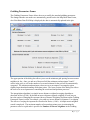
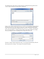
The Gridding Parameters Frame allows the user to modify the standard gridding parameters.
The changes that the user makes are automatically passed back to the Map Brine Data Frame,
also if the Brine Data Well Map is displayed; the data is automatically updated in the plot.
The upper portion of the dialog box allows you to set the minimum grid spacing between nearest
neighbors in feet. Once you tab out of that text field the minimum and maximum X and Y
values in the grid, as well as the number of rows and columns for the grid will be automatically
computed. The minimum and maximum values are set to encompass a rectangular region
slightly larger than that bounding all the data points. The lower portion of the dialog box allows
the user to set several parameters controlling the search and interpolation processes.
The interpolation algorithm is a simple inverse distance weighted averaging algorithm as
described in Davis (1986). By default an inverse distance-squared weighting is used, but you
have the option of changing the exponent (Inverse Distance Weighting Exponent on the Gridding
Parameters Frame) so that, for example, you could use inverse distance (exponent=3) weighting.
The effects of varying the exponent are described in Davis(3) (1986). A simple nearest neighbor
search is employed. The maximum number of nearest data points to use in estimating the
parameter value at a grid node is specified as Number of Nearest Neighbors in the Gridding
8|Page