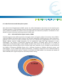
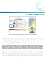
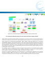
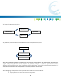
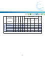
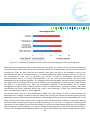
1
Joint European Research Infrastructure network for Coastal Observatories Report on best practice in conducting operations and maintaining D4.4 Grant Agreement n° 262584 Project Acronym: JERICO Project Title: Towards a Joint European Research Infrastructure network for Coastal Observatories Coordination: P. Farcy, IFREMER, [email protected], www.jerico-fp7.eu: Authors: Petihakis G., Sorensen K., Hernandez C., Testor P., Ntoumas M., Petersen W., Mader J., Mortier L. Involved Institutions: HCMR, OGS, NIVA, CSIC, AZTI, HZG, SMHI, CNRS Version and Date: V1 - 27/02/2012 Table of Contents 1. DOCUMENT DESCRIPTION 9 2. EXECUTIVE SUMMARY 12 3. INTRODUCTION 15 4. FERRY BOX 17 4.1. Commercial FerryBox-systems 4.1.1. 4H-Jena system 4.1.2. SubCtech – OceanPack AUMS 4.1.3. Aanderaa - SooGuard 4.1.4. GO-SYS 18 18 21 22 23 4.2. 24 Commercial sensor available for FerryBoxFerryBox installations 4.3. Other fluorescence and absorption systems 4.3.1. Coloured dissolved organic matter, CDOM 4.3.2. Phycobilins 4.3.3. Fluorescence induction techniques 4.3.4. Multichannel fluorescence sensor 4.3.5. Integrating cavity absorption meter 27 27 30 33 34 34 4.4. Measurements of the marine carbon system parameters 4.4.1. State-of-the-art high precision pCO2 system 4.4.2. Membrane based pCO2-systems 4.4.3. Photometric and fluorescence methods for pH 4.4.4. Total Alkalinity 35 37 39 42 46 4.5. Nutrient analysers 47 4.6. Sampling for contaminants 50 JERICO –WP4-Del. 4.4-270212-V1 .3 4.6.1. 4.6.2. Passive Sampler (CEFAS) Passive sampler (NIVA) 50 52 4.7. Automatic water sampling and preservation 55 4.8. Above water installation and connection to ship installations 57 4.9. FerryBox infrastructure planning and installation 4.9.1. Shipping company 4.9.2. Ship type 4.9.3. Ship route 4.9.4. Ship Regulations 4.9.5. Water Inlet 4.9.6. Pump 4.9.7. Valves and water supply lines 4.9.8. Choice of System 4.9.9. Electrical Considerations 59 59 60 61 62 63 64 64 65 65 4.10. FerryBox system maintenance and calibration 4.10.1. System and sensor maintenance 4.10.2. Sensors and instruments calibration and QA 67 67 68 4.11. FerryBox data management and processing 4.11.1. Data management for different parameters 4.11.2. Data flow and quality control (QC) for automated measurements 4.11.3. Data flow and quality control for measurements from water samples collected 4.11.4. Data management and QC developed in MyOcean 70 70 71 76 77 4.12. 79 5. 5.1. Data Archiving and dissemination FIXED PLATFORMS 81 Fixed platform definition and types 81 5.2. Platform design 5.2.1. Observing purpose: Parameters to measure and sensors selection 5.2.2. Geographical location 5.2.3. Mooring types Mooring design Mooring line components 84 86 92 93 93 96 JERICO –WP4-Del. 4.4-270212-V1 .4 5.2.4. Materials 5.2.5. Data transmission 5.2.6. Energetic autonomy 5.2.7. Suppliers 5.2.8. Infrastructure Material Human 5.2.9. Future upgrades 5.3. 100 104 105 106 106 106 107 107 Sensors 107 5.4. Telemetry 5.4.1. Platform to onshore receiving station 5.4.2. Underwater communications Cabled communication Acoustic modems Inductive modems 5.4.3. Positioning system 112 112 114 115 116 119 119 5.5. Power systems 5.5.1. Energy storage 5.5.2. Power generation Solar panels Wind turbines Diesel generators 120 120 120 121 121 121 5.6. Platform operation 5.6.1. Biofouling 5.6.2. Corrosion 5.6.3. Vandalism on fixed stations 121 121 124 125 5.7. Deployment-Installation procedures 5.7.1. Pre-deployment 5.7.2. Deployment 5.7.3. Recovery 126 126 127 128 5.8. Maintenance 5.8.1. Station maintenance On site: On land: 129 129 130 131 JERICO –WP4-Del. 4.4-270212-V1 .5 Sensors maintenance: Sensors operating in the air Sensors operating in the sea 131 132 132 5.9. Data validation 5.9.1. On site 5.9.2. In the laboratory 133 134 136 5.10. 138 6. Data handling GLIDERS 143 6.1. Glider Technologies 144 6.2. Glider Insfrastructure 145 6.2.1. Laboratory 145 6.2.2. Ballast Tank 146 6.2.3. Pressure chamber 146 6.2.4. Calibration 146 6.2.5. Storage 148 6.2.6. Communications 148 6.2.7. Control Room 150 6.2.8. Data Centers 151 6.2.9. Vehicles 151 6.2.10. Vessels 152 6.3. Glider Platforms in the Laboratory 152 6.4. Glider Missions 153 6.5. Glider Missions 162 JERICO –WP4-Del. 4.4-270212-V1 .6 6.6. Glider Missions 162 6.7. A coordinated strategy 163 6.8. A coordinated strategy 167 6.9. Glider Cost Analysis 167 7. CONCLUSIONS 169 ANNEXES AND REFERENCES 171 JERICO –WP4-Del. 4.4-270212-V1 .7 1. Document description REFERENCES Annex 1 to the Contract: Description of Work (DoW) version XX 1.1.1.1. Document information Document Name Report on best practice in conducting operations and maintaining Document ID Revision Revision Date 26/06/2012 Author G. Petihakis Security History Revision Date Modification Author Diffusion list Consortium beneficiaries X Third parties Associated Partners JERICO –WP4-Del. 4.4-270212-V1 .9 This document contains information, which is proprietary to the JERICO consortium. Neither this document nor the information contained herein shall be used, duplicated or communicated by any means to any third party, in whole or in parts, except with prior written consent of the JERICO Coordinator. The information in this document is provided as is and no guarantee or warranty is given that the information is fit for any particular purpose. The user thereof uses the information at its sole risk and liability. JERICO –WP4-Del. 4.4-270212-V1 . 10 2. Executive Summary The seas and oceans are an intrinsic part of the earth and climate systems. They cover 70% of our planet, provide 95% by volume of its biosphere, support more than 50% of global primary production and harbour an enormous diversity of life adapted to extremely broad-ranging environmental conditions. The oceans are a driver of our climate but are also affected by climate change and ocean acidification. They are under increasing pressure from human activities and pollution, and growing coastal populations. The combination of natural and human-induced changes taking place in our seas and oceans including, for example, rising temperatures, the melting of Arctic sea ice, ocean acidification, increasingly extreme weather events, transfer of non-indigenous marine species, changes in biodiversity and species distribution, and depletion of fisheries stocks, may have potentially profound impacts on our societies and economies in the medium-term. European research focused on the seas and oceans is central to addressing these challenges by delivering knowledge and tools to enable Europe to prepare for, and adapt to, these changes. Moreover The growth of new and existing industries such as marine renewable energy, marine biotechnology, fisheries and aquaculture and sustainable maritime transport must be supported by research and innovation, involving a range of actors to develop technologies and best practices in support of a thriving European maritime economy. A key issue is how will society be placed in the coming decades to tackle these threats and turn challenges into opportunities? The Rio Ocean declaration (16 June 2012) called for an “integrated approach addressing the interlinked issues of oceans, climate change, and security” and for countries to “Establish the scientific capacity for marine environmental assessment, monitoring, and prediction, including the implementation of……the global ocean observing system”. Routine and sustained ocean observations are crucial to further our understanding of the complex and vast oceanic environment and to supply scientific data and analyses sufficient to meet society’s needs. In particular for the coastal environment, needs are even higher as the natural variability is interlinked with the human induced and efforts to identify and distinguish the various components are crucial. Furthermore most economic activity is based at the coastal ocean. Europe spends €1.4 billion p.a. for marine data collection: €0.4 billion for satellite data and €1.0 billion for insitu observations, respectively. In the case of the latter, the traditional and expensive practice of vessel-based data-gathering is progressively giving way to monitoring via “observatories” - complexes of distributed, autonomous, real-time sensor systems. Burgeoning technology and pressing societal needs will soon make such observatories the backbone of European marine observing activity because of their ability to provide copious quantities of diversified data over large areas at reasonable costs. JERICO –WP4-Del. 4.4-270212-V1 . 12 Around European coastal seas, the number of marine observing systems is quickly increasing under the pressure of both monitoring requirements and oceanographic research. Present demands for such systems include reliable, high-quality and comprehensive observations, automated platforms and sensors systems, as well as autonomy over long time periods. In-situ data collected, combined with remote sensing and models output, contribute to detect, understand and forecast the most crucial coastal processes over extensive areas within the various national and regional marine environments. Coastal observations are an important part of the marine research puzzle of activities and applications. However significant heterogeneity exists in Europe concerning technological design of observing systems, measured parameters, practices for maintenance and quality control, as well as quality standards for sensors and data exchange. Coastal observatories have been developed in Europe in a rather uncoordinated way. Usually based on national funding and priorities these observatories have very diverse design and architecture and have established very different practices for their operation and maintenance. For certain subsystems (e.g. FerryBox) past EU projects have established a network of operators through which experience and best practices have been shared but this is not the case for other observing platforms, and certainly not for integrated coastal observatories. Considering the importance of observing systems and the substantial investment made until now, an important task of JERICO is to describe best practices in all phases of the system (pre-deployment test, maintenance, calibration etc); to adopt common methodologies and protocols and to move towards the harmonisation of equipment which will help in reducing maintenance and calibration costs. These efforts are described and analysed in depth in this deliverable. JERICO –WP4-Del. 4.4-270212-V1 . 13 14 3. Introduction Scientific discovery and understanding of the oceans has paved the way for human activities in the marine environment. Significant progress in international ocean observation has been made over the past decade (Busalacchi, 2010) and ocean observatories now produce crucial datasets to further our knowledge on oceanic processes including, for example, heat content, ecosystem and carbon dynamics, air-sea interaction, ocean acidification, and ocean floor substrate-fluid processes. Coastal ecosystem dynamics are inherently non-linear and resolving temporal and spatial variability in the coastal oceans remains notoriously difficult. Interpretation of ocean processes is often further hindered by a lack of multidisciplinary oceanographic timeseries datasets at high enough resolution or from specific locations of interest. The non-linearity means that perceived trends in ecosystem indicators can be short-lived and variables often display a delayed response time to pressures and larger-scale climate drivers. Indeed, studies have shown that statistically robust trend analysis requires long-term time-series datasets and that a high variance of ecological indicators can reduce the statistical power for detecting trends in series of less than 10 years. In turn, studies have shown that for remotely sensed data, 40 years of ocean observations are required to separate natural modes of climate variability from longer-term trends of a changing climate and ocean. The past decade has seen a major effort towards developing marine observations targeted at a better understanding of biogeochemical cycling and ecosystem services. Methods for ocean observation are constantly evolving and innovation is an essential driver for science and engineering excellence and technological advancement. New smart sensors, techniques and platforms are emerging to provide automated solutions to multidisciplinary marine monitoring. In terms of in situ ocean observation, improvements to sensitivity, accuracy, stability, resistance to oceanic conditions and depth rating are all key to ensuring high quality, sustained data. An increased interest and effort in ocean observation in the 1990’s led to a huge technological advancement in automated sensors for monitoring physical variables such as temperature, salinity and currents. Much work is focused on minimizing power requirements and reducing the size of sensors towards miniaturized labon-a-chip micro sensors to minimize the payload and enable multi-parametric observation from single platforms such as gliders and drifting buoys. Operation and maintenance activities are probably the most crucial elements in the life-cycle of a research infrastructure and in some cases even more demanding than the design and construction of the infrastructure itself. Their successful implementation guarantees the good performance of the infrastructure and the protection of the investment. Coastal observatories have been developed in Europe in a rather uncoordinated way. Usually based on national funding and priorities these observatories have very diverse design and 15 architecture and have established very different practices for their operation and maintenance. For certain subsystems (e.g. FerryBox) past EU projects have established a network of operators through which experience and best practices have been shared but this is not the case for other observing platforms, and certainly not for integrated coastal observatories. 16 4. Ferry Box Involved partners: NIVA, HZG, SYKE, CEFAS, SMHI, NOC, HCMR Lead : NIVA Authors: Kai Sørensen, Wilhelm Petersen, Michael Haller, Jukka Säppäle, Seppo Kaitala, Dave Sivyer, Bengt Karlson, Anna Willstrand, and Mark Hartman. 1. Introduction The use of Voluntary Ships (VOS) or ships of opportunity systems (SOOP) with automatic sensors have been in operation for decades in Europe. At the Norwegian coast the coastal steamer (Hurtigruten) operated already in the 1930s with temperature sensors on the water intake. This has now produced a very long time series with high importance in climate studies. With the start of the EU FerryBox project in 2003 this platform for environmental studies has developed further from “home made” automatic sensor packages to more commercial systems that today are delivered from several sensor companies. Most FerryBoxes are characterised by the measurement of some core variables like Temperature, Salinity, Chl-a fluorescence and turbidity. Different sensors are on the marked and are used by the FerryBox operators in Europe. To enable regional comparisons (FerryBox to FerryBox), this diversity in sensors and variables requires transparency in best practices in all phases of the setup (e.g. sensor type, deployment, housing, calibration etc). Such transparency will enable adoption of common procedures and hence lead to better quality assurance. The FerryBox is an automated system used for measuring of physical and biogeochemical parameters in surface waters. It is mounted on SOOPs, such as ferries or container ships, on their regular routes across the Sea or on shore-based installations. Water is pumped from a subsurface inlet into the measuring circuit of multiple sensors. An important feature is the regular automated cleaning and antifouling procedure of the box. 17 Data are transmitted and made available in real-time (satellite connection) or after each transect in the harbour (mobile phone connection). The regular transects of physical and biogeochemical observations give detailed insights into the processes and can be used for data assimilation into models (Petersen, 2014). This best practice report gives an introduction to the most important technical and practical issues concerning FerryBox installations e.g. which commercial FerryBox system are available, what are the FerryBox community uses of core sensors, state-of-the-art of more advances system and what to be specially aware of concerning installation, maintenance, calibration and data handling. Examples of how different FerryBox operators have developed the their own system are reported and also some state-of-the-art on new biogeochemical sensors that are close or in the near future to be in routine operation are addressed. 4.1. Commercial FerryBox-systems After the first attempt by some FerryBox operators by building their own systems using stand alone commercial sensor some commercial systems came on the marked and several sensor companies are now delivering FerryBox systems. 4.1.1. 4H-Jena system The 4H-FerryBox is an automatic, low-maintenance measuring system to monitor water parameters, manufactured by 4H-Jena (http://www.4h-jena.de/). It was especially developed for continuous deployment on ships, in fixed platforms and in the sea or river monitoring stations. The modular architecture allows the integration of various sensors of different manufacturers, the connection of analysers and automatic samplers and in particular measurements in difficult media (e.g. sea water, oxygenated water etc.). The integrated automated cleaning feature prevents the growth of biofilms even at the beginning. The entire system is flushed with tap water, acidified water or even hypochlorite solution on a regular basis either daily or after each cruise. Due to this anti-fouling system maintenance is kept to a minimum The control, data management and data visualization on LabView-based software allows automatic long-term measurements. In conjunction with a corresponding communication module remote control and tele maintenance as well as geo tagged measurement or even series of position-dependent measurements are 18 possible. Currently, two 4H-FerryBox versions and one small portable box are available. 4H-FerryBox I Application: Long-term operational oceanography and water quality monitoring Characteristics: Open system, suitable for many sensors and analysers for water quality. Easy installation of customer‘s sensors. Extension with nutrient analysers, pCO2 etc. Effective automated cleaning and anti-fouling system. Filtration system easy to install. Restrictions: Open system. Either free water outflow possible or external pump system necessary. Relatively large and heavy. 4H-FerryBox II Application: Long-term operational oceanography and water quality monitoring & short-term ship applications. Characteristics: Closed system can be operated under the water line of the ship. Simple automated cleaning and anti-fouling system. Small and light system. Restrictions: Only pressure-resistive sensors can be installed. Number of additional sensors is restricted. 19 Figure 4.1.1: 4H-FerryBox I (left) and 4H-FerryBox II (right). 4H-PocketFerryBox Application: Field experiments in combination with sampling campaigns etc. Characteristics: Portable system, can be operated from small boats. „Measurements on the spot“. Fixed maximal number of sensors, which are relevant to biological experiments. Battery operation, suitable for air transport (25 kg). Restrictions: Only manned operation (no automated control mechanism). Only manual anti-fouling procedures. 20 Figure 4.1.1. 4H-PocketBox. 4.1.2. SubCtech – OceanPack AUMS The OceanPack AUMS consists of several SubCtech products. It comprises for instance the proved LI-COR® pCO2 analyzer with the data management SubCtech SmartDI® (Smart Data Interface) data logger. This data logger is additionally equipped with various connection types to enable the integration of other probes or analyzing systems. The integrated "auto-calibration" function, for e.g. the pCO2 analyzer and optional automatic cleaning routine, enables the applications without supervision. The monitoring system is suitable for vessels and offshore work under rough environmental conditions. Battery operations - e.g. on buoys or remote measuring stations - are possible, as the power consumption is low. The optional RS-485 industrial bus allows controlling for example external pumps or valves. It enables at the same time the integration of external measuring equipment, such as meteorological instrumentation (Top-Box™, optionally equipped with additional sensors). 21 Figure 4.1.2. OceanPack AUMS of SubCtech. 4.1.3. Aanderaa - SooGuard The AADI version of FerryBox named SooGuard consists of an automated package of different sensors designed for long-term installation on a ship of opportunity. The system offers easy maintenance and flexibility to collect data from a ship of opportunity. It is based around a 10 bar pressure housing for waterflow and measurements. Embedded sensors are connected to a SmartGuard data collection platform for data logging and telemetry. More details can be found on http://www.aanderaa.com/. The standard parameters being measured are: Conductivity Oxygen Chlorophyll-a Fluorescence Water flow in the tube Optional parameters to measure: CDOM pH Turbidity Most third party sensors GPS Other parameters on demand 22 GPS data from the boat may be collected by the SmartGuard data logger. Some additional water parameters available from the boat can also be collected by the data logger (meteorological data, etc.). Real-time data transmission is possible depending on the ship’s capabilities. Figure 4.1.3. SooGuard FerryBox system of Aanderaa. 4.1.4. GO-SYS The BlueBox is the central panel of a modular measuring and controlling system, designed by GO-SYS (http://www.go-sys.de/1/home/). The BlueBox can be connected to both sensors (e.g. temperature, compression or conductivity) and actuators (e.g. relays, pump) by CAN-Bus (Controller Area Network) technology. It is designed for multiple purpose not only FerryBox applications. In mobile use the attachment of a GPS for a continuous determination of its position is optionally possible. For data processing and its communication the BlueBox is equipped with the established interfaces. Besides sensors and actuators of GO-SYS products of other manufacturers can be included. The transfer of data, results and the communication is effected by modem, ISDN, GSM or Bluetooth. 23 Figure 4.1.4. Go-Sys Bluebox. 4.2. Commercial sensor available for FerryBoxFerryBox installations The core sensor for FerryBox installations are temperature, salinity, oxygen, Chl-a fluorescence and turbidity. In the following the most used commercial sensor used in the FerryBox community are listed. Temperature The measurement of water temperatures is one of the core tasks in continuous physical ocean observation. The water temperature is a main driver of ocean circulation and vertical stability. The widely used measurement principle consists of the temperature dependence of the electric resistance of platinum and thus is named PT. Measurement principle Sensor Manufacturer User Pt 2000 SBE Temp sensor 38 Sea-Bird Electronics SYKE, SMHI, NIVA, RNIOZ, MIO PT100 SBE 45 Micro TSG Sea-Bird Electronics NIVA,Cefas, HCMR PT100 EXCELL TSG FSI, Now Instruments aged thermistor SBE 16 plus SeaCat Sea-Bird POL Sea-Bird NOCS aged thermistor reference resistor and VISHAY SBE 48 hull mounted 24 Teledyne RD HZG, MSI, Cefas Salinity (Conductivity) The parameter salinity is besides the water temperature one of the most important physical ocean parameters. Both are conservative parameters that can be used e.g. for tracer analyses. Differences of salinity influence strongly the horizontal and vertical ocean circulation. The dominant measurement principle is the dependence of conductivity to saline waters which can be measured either by cell resistance or inductively. Measurement principle Sensor Manufacturer User cell resistance SBE TSG 45 Sea-Bird Electronics inductively EXCELL TSG FSI (USA) SYKE, SMHI, NIVA, HCMR, MIO, Cefas HZG, MSI cell resistance SBE-21 Seabird Electronics RNIOZ cell resistance SBE 16plus SeaCat Sea-Bird Electronics POL induction cell CTG MiniPack Chelsea Technologies Ltd NOCS induction cell 3919B Aanderaa NOCS Oxygen Oxygen is one of the key parameters of existing life in the oceans and, therefore, an important ocean observation parameter. It is monitored via electro-chemical principles (e.g. Clarke electrode) or optical measurement principles (optodes). Also required for reliable oxygen observation are reliable temperature and salinity observations. Measurement principle Sensor Manufacturer User Optical by dynamic luminescence quenching Clark electrode Optode (Mod 4835 or 3830) COS4-2 Aanderaa SMHI, Cefas NIVA, HZG, NOCS, HCMR HZG Endress & Hauser (Germany) Chl-a Fluorescence Chlorophyll is an important biomolecule, and a core element in photosynthesis, which allows algae to absorb energy from light. Chlorophyll absorbs light most strongly in the blue part of the electromagnetic spectrum. 25 The dominating measurement principle is the fluorescence of Chlorophyll-a. Fluorescence can be measured by sending a defined wavelength of light onto a water body containing chlorophyll and measuring the level of light emitted at longer wavelength. Measurement principle Sensor Manufacturer User Chl-a fluorescence ECO FLNTU WETLabs (USA) SYKE, SMHI, Chl-a fluorescence SeaPoint Sensor Inc Cefas, RNIOZ Chl-a fluorescence Chlorophyll-a meter (SCF) TriOS MicroFlu TriOS (Germany) NIVA, SYKE, HZG Chl-a fluorescence Scufa II Turner design (USA) HZG, HCMR, MSI Chl-a fluorescence CTG Mini-Tracka II Chelsea Instruments Ltd POL Chl-a fluorescence CTG MiniPack Chelsea Instruments Ltd NOCS Chl-a fluorescence Turner C3 Turner NOCS Chl-a fluorescence, excitation by different wavelengths AoA Bbe (Germany) HZG fluoro- Turbidity Turbidity is the cloudiness or haziness of a fluid caused by large numbers of individual particles that are generally invisible to the naked eye. Thus, the turbidity is a key test of water quality. The most widely used measurement unit for turbidity is the Formazin Turbidity Unit (FTU). ISO refers to its units as FNU (Formazin Nephelometric Units). This sensor are measuring the scattering of light at a preferably at the infrared wavelength to follow the ISO standard. Measurement principle Sensor Manufacturer User light scattering (blue) ECO FLNTU WETLabs SYKE, SMHI light scattering 880 nm Turbidity sensor SeaPoint Sensor Inc POL light scattering 880 nm Turbidity sensor Polymetron sensor NIVA light scattering (blue) Scufa II Turner design (USA) HZG, HCMR, MSI light scattering (red) CUS31-W2A Endress & Hauser (Germany) HZG light scattering Cyclops Turner design (USA) HZG 26 4.3. Other fluorescence and absorption systems New chemical and biogeochemical (BGC) sensors are under development and some are also used by some FerryBox operators. In the following some of the sensor systems that are used by operators and that will be more commercial available the years to come are listed. Also the theoretical principle is introduced in more details for some of the most interesting sensors for BGC work. 4.3.1. Coloured dissolved organic matter, CDOM Dissolved organic carbon (DOC) represents the largest fraction of organic carbon in the oceans. Part of DOC is coloured (CDOM) and absorbs light strongly at UV and blue wavebands. CDOM (synonyms: yellow substances, gelbstoff, gilvin) consists of humic and fulvic acids that are produced during degradation of terrestrial and aquatic organic material. CDOM absorption has an exponential shape with high absorption at short wavelengths. The amount of absorption describes the amount of CDOM, which may be related to concentration of dissolved organic matter (DOM) and DOC. Slope factor for the absorption, S, is a proxy for CDOM quality (eg. characterizing its fulvic to humic acids ratio, molecular size or its origin). A sub-fraction of the CDOM is fluorescent (fCDOM) (Figure 4.3.1.). Different fractions of fCDOM, terrestrial, marine, and anthropogenic, can be studied with spectral fluorometry, as different components can be differentiated by their excitation and emission maxima. Typically, the purpose of CDOM studies is to estimate the amount of DOC and DOM, their origin and dynamics and analyze water mixing. 27 Figure 4.3.1. Dissolved organic carbon (DOC) comprises of large variety of different organic compounds. Part of them are coloured (CDOM) and part of CDOM is fluorescent (fCDOM). While DOC, CDOM and fCDOM often covary at given site, their ratios vary depending on the quality of organic matter and there are no universally valid conversion factors. Overall, the fluorometric detection of CDOM is much more sensitive than measuring absorption. Direct measurements of CDOM absorption requires that the water sample is filtrated (through 0.2µm) and crossflow filtration system may be used. Such systems are rarely used in operational monitoring. CDOM absorption may also be estimated from the total absorption measurements (see PsiCAM) at the sites where CDOM is a significant optical component. Spectral fluorescence, excitation and emission characteristics, of CDOM reflect the quality and quantity of various fCDOM components (figure 4.3.2). Such measurements are not typically carried out during operational monitoring of fCDOM. Fluorescence measurements of CDOM can be done using fixed wavelength LED systems. Optimally, the wavelengths are selected based on the most important fCDOM components available at study site, although such studies seem to be rather scares and instrument specific variations are not well studied. For commercial instruments the excitation wavelength varies from 255 to 370 nm, while emission wavelength from 430 to 460 nm, at least (figure 4.3.2). In addition, multichannel phytoplankton fluorometers may include a specific channel for CDOM (See multichannel fluorometers), though their usability in tracking CDOM has been rather poorly demonstrated for coastal waters. With LED fluorometers using fixed (and typically wide) wavelengths one cannot detect the quality of fCDOM but only relative quantity. In addition to fCDOM fluorometers, UV excitation can be used to detect hydrocarbons. As the optical signals of hydrocarbons (e.g. oils) and fCDOM may overlap, it is recommended that any use of hydrocarbon fluorometry is accompanied with fCDOM fluorometer, to avoid misinterpretation of hydrocarbon fluorometer readings in the case of high fCDOM abundance. 28 Figure 4.3.2. CDOM excitation-emission fluorescence matrix showing the location of CDOM fluorescence. Sample is from the Baltic Sea. Black ovals overlayed in data show approximate spectral ranges for two commercial fCDOM fluorometers, indicating that they measure different fCDOM components. Calibration of fCDOM fluorometers which have measuring wavelengths around 350 nm range, are typically done using quinine sulphate solutions. Then the results can be expressed as quinine sulphate equivalents (mg/L). The readings from two optically different fCDOM fluorometers cannot be directly compared against each other, as the wavelengths of fCDOM and quinine sulphate used in calibration differ. Instruments using very low excitation wavelengths cannot be calibrated with quinine sulphate but carbazole or perylene may be used. Yet another issue with fCDOm calibration is the temperature dependency of fCDOM fluorescence yield, which should be studied for each fluorometer type separately. Otherwise, the best practices in applying fCDOM fluorometers in ferrybox systems equal those of other fluorometers. fCDOM readings are not directly comparable to CDOM absorption or DOC measurements (figure 4.3.3). The ratio between these variables varies depending on the DOM quality and thus has both spatial and seasonal trends, which need to be examined for each site. 29 Figure 4.3.3. Relationship between fCDOM measured in ferrybox and CDOM absorption and DOC concentration measured from discrete water samples. The variations in the relationship indicate spatial differences in the quality of DOM. 4.3.2. Phycobilins In addition to Chlorophyll a, phycobilin pigments, phycoerythrin and phycocyanin, are easily detected using in situ fluorometers. While Chlorophyll a is present in all algal classes, phycobilins are found in only few taxonomic classes. Cyanobacteria contain always three forms of phycobilins, though their relative contents vary a lot and some phycobilins may be found only in trace amounts. Cryptophytes typically contain either phycoerythrin (oceanic and coastal species) or phycocyanin (lake and some coastal species). In addition, red algae and some dinoflagellates contain phycobilin pigments, as well as phototrophic ciliate Myrionecta rubra (also known as Mesodinium rubrum). There are four major classes of phycobilins, with different optical properties. Phycoerythrin can be found in two basic forms, the one absorbing at lower wavelengths is typically found in oceanic cyanobacteria, while the other absorbing at longer wavelengths is found in coastal cyanobacteria. Excitation and emission maxima for phycoerythrins vary from 490 to 575 nm and from 570 to 580 nm, respectively. Phycoerythrocyanin replaces phycoerythrin in few cyanobacteria species (exc. 570-595 nm / em. 625-635 nm). Phycocyanin (exc. 615-640 nm / em. 635-645 nm) and allophycocyanin (exc. 620-655 nm / em. 660-675 nm) are two additional phycobilins. It is noteworthy that various subforms of phycobilins exist, modifying the exact position of absorption and emission maxima wavelengths. Typically phycobilin fluorescence is used to detect cyanobacteria, which are largely ignored with Chlorophyll a fluorometry as their chlorophyll is in pigment complex showing very low fluorescence yield. The amount of 30 other phycobilin containing species, of course, influences cyanobacteria to phycobilin relationship. Phycobilin fluorescence can be related to phycobilin pigment concentrations, though analytical methods for phycobilin concentration estimates are very poorly developed and the studies of fluorescence-concentration relationship are not available for natural communities. In addition, fluorescence yield of phycobilins is known to vary depending on their connectivity in phycobilisomes, which is largely determined by physiological state of cells. Further, especially for cyanobacteria, phycobilin content of cells is very dynamic and regulated by the abundance of nitrogen and light (Figure 4.3.4). In phycobilin fluorometry, it is important to study the optical properties of phycobilin containing organisms in the study site, in order to determine which phycobilins are abundant and how they are related to different taxonomic classes. Secondly, it is important to select instruments with suitable wavelengths, matching the optical properties of phycobilins found. LED fluorometers for phycoerythrin are quite simple to construct as their wavelengths are clearly separated from other pigments. Phycocyanin fluorometers detect in reality both phycocyanin and allophycocyanin, as their wavelengths are very close to each other. In addition, some commercial phycocyanin fluorometers have biased wavelengths and are affected by phycoerythrin or chlorophyll fluorescence (Figure 4.3.5.). In fact, all phycocyanin fluorometers are affected by chlorophyll fluorescence at some level. It is recommended that when phycocyanin fluorescence is recorded, also chlorophyll a fluorescence is measured, to get some estimate of Chlorophyll signal leaking to phycocyanin channel. Figure 4.3.4. Relationship between nitrogen content of cyanobacteria Nodularia spumigena (C:N ratio) and phycocyanin content (measured as phycocyanin to Chlorophyll a ratio, based on absorption), showing that the phycocyanin content decreases when nitrogen content decreases. (Data from Ylöstalo, Seppälä, Raateoja, 31 unpublished). Major challenge in using phycobilin fluorometers is their calibrations. Some commercial manufacturers of phycobilin fluorometers state that their device measure the cell density (# of cells per mL). As cell size varies between species, as well as phycobilin content, this is very inappropriate. Alternatively, some instruments have been calibrated with purified phycobilins resulting in readings at equivalent to concentration of pure phycobilins. This may be more appropriate, but is strictly not correct as fluorescence properties of phycobilins vary depending on the matrix. Thus far the working solution has been relating the phycobilin fluorescence records to cells counts in water samples or to the amount of extracted phycobilins. Although usable for specific locations, such calibrations do not support instrument-to-instument comparison, and new calibration and validation methods are needed. Figure 4.3.5. Excitation emission fluorescence matrix for phycocyanin containing cyanobacteria (left), phycoeryhtrin containing cyanobacteria (middle) and phycobilin lacking green algae (right). Fluorescence of phycocyanin: excitation 630 nm and emission 655 nm, fluorescence of phycoerythrin: excitation 560 nm and emission 570 nm (with secondary emission at 650-680 nm) and fluorescence of Chlorophyll a: excitation 400660 nm (due to accessory chlorophylls and carotenoids) and emission at 680 nm. The table above figure shows the wavelength settings of commercial phycocyanin fluorometers. Some of the phycocyanin fluorometers match exactly the phycocyanin fluorescence peak (yellow circle) and have a minimal influence from other pigments, while some fluorometers are influenced by phycoeryhtrin or chlorophyll fluorescence, or both (red ellipse). 32 4.3.3. Fluorescence induction techniques Variable fluorescence provides means to detect health and photoacclimation state of phytoplankton community. In the simplest version, the chlorophyll a fluorescence of sample is measured from dark acclimated sample before (F0) and after (Fm) closure of functional photosystems (e.g. using intense light pulse), resulting in information on the efficiency of photosystem II ([F m- F0]/ Fm = Fv/ Fm). Fluorescence induction can be measured using multiple turnover technique (MT; e.g. pulse amplitude modulation, PAM) or single turnover technique (ST; e.g. Fast repetition rate fluorometry, FRRF). In MT technique, a long light flash (50-1000 ms) will close all reaction centers of photosynthesis, and fluorescence will increase in sudden. In ST technique, a train of short intense light flashes (1-2 µs duration) will cumulatively close reaction centers and the fluorescence rise will be followed, allowing also calculation of absorption cross section. Besides information on fluorescence levels, calculation of electron transport rate requires some information on ambien light level and absorption properties of cells. In the most advanced systems today, ambient light levels the samples are acclimated can be varied resulting in a fluorescence – light response curves (in analogy to production – light curves). The results obtained are then valid for various light levels and they can be recalculated to match natural conditions with fluctuating light levels e.g. vertical profiles or diel cycles. At best the results represent electron transport rate, and the conversion to carbon uptake or oxygen release is not straight forward. Currently the key research topics include determination of these conversion factors for different sea-areas and different seasons. Novel FRRF and PAM versions include several wavebands, to separate fluorescence signals from various phytoplankton pigment groups. Fluorescence is excited using LEDs (440-610 nm) and the fluorescence is detected at around 680 nm. The usability of the instruments to measure group specific photosynthetic parameters is still under scrutiny. 33 Fig 1.3.6. Fast repetition fluorometer tested in lab (left, Chelsea Instruments) and installed on FerryBox system (Photon Systems Instruments). 4.3.4. Multichannel fluorescence sensor The bbe AlgaeOnlineAnalyser is an instrument for continuous monitoring of algae respectively chlorophyll-a. In a water sample, the chlorophyll concentration of the different algae classes can be retrieved. Besides the total concentration of chlorophyll, also the concentration of up to 5 algae groups and yellow substances can be measured. The fluorescence is measured by excitation at different wavelengths. For the differentiation of different algae classes, a spectrum of the mixture is recorded and the different algae classes in the sample can be retrieved with the help of statistical procedure. The data are analysed by a microcontroller integrated into the sensor unit. After a certain number of measurements, the cuvette is cleaned automatically by the cleaning device. Figure 4.3.7: AlgaeOnlineAnalyser bbe moldaenke. 4.3.5. Integrating cavity absorption meter The amount of light absorbed by seawater at different wavelengths can provide information about its constituents like phytoplankton, other particulate matter, or yellow substance. However, accurate measurements of natural water samples suffer from often low concentration of absorbing material as well as from errors introduced by light scattering on particles. For most instruments, these errors have to be corrected empirically. Laboratory integrating cavity measurement systems like the point-source integrating cavity absorption meter (PSICAM; e.g. Röttgers et al. (2005)) overcome the problem of particle scattering by introducing the sample in 34 a diffuse light field set up in an integrating tube or sphere, respectively. Simultaneously, this setup enhances the optical path length, enabling highly sensitive, hyperspectral measurements of absorption coefficients. The flow-through-PSICAM (ft-PSICAM) is similar to the previous developed conventional PSICAM as described and used by Röttgers et al. (2005). However, the cavity of the ft-PSICAM is made from PTFE and has been equipped with water inlets and outlets to enable flow-through operation. For illumination of the cavity, a 150-W IT 3900 lamp (Illumination Technologies, USA) was used. Light leaving the cavity was detected by a Ramses UV/VIS-spectrometer (TriOs, Germany) in a range from 400 to 710 nm. The ft-PSICAM is specially designed to be connected to a FerryBox which collects other parameters important for the correction of the absorption coefficients like salt and temperature. More details to this system can also be found in Wollschläger et al. (2013). Figure 4.3.8. Flow-through PSICAM developed at HZG. 4.4. Measurements of the marine carbon system parameters The assessment of anthropogenic impact on marine carbon system is increasingly demanding the deployment of instrumentation capable to detect changes at the level necessary to understand and estimate future trends. Ocean acidification monitoring is steadily on the forefront within international research programs. In order to establish a global network of monitoring stations, improving stability of detection and limiting costs arising from maintenance are still a major concern. Global effects on surface 35 ocean have been assessed and commonly accepted to drive the surface ocean pH with a trend of -0.002 units per year, while seasonal variation are ten times higher. Tracking such changes for extended periods will achieve to early detect and reveal interactions of water masses, local anthropogenic interactions and seasonal variability. To achieve the best estimate of pCO2 changes in marine system the accuracy of pCO2 shall be better than +/1% over the range 200 to 1000 µatm and a precision better than +/- 0,5 %.This has up to know only been possible with the advanced General Oceanic pCO2 systems. In the more traditional FerryBox community the sensors that presently are used are the membrane based pCO2 systems. In addition pH need to be measured and the stat-of-the-art method are the photometric (total scale) pH systems, but some FerryBox-systems still use the potentiometric (NBS-scale) electrode system The accuracy for both the membrane based pCO2 and pH are still to be improved and validated. Projects are ongoing to develop and validate these systems into more fully operational use. In Figure 4.4.1 an installation of a NIVA-Franatech membrane based system and a General Oceanic pCO2 system (from GEOMAR) are shown to illustrate the difference in design Figure 4.4.1. Installation of a NIVA-Franatech membrane based pCO2 system (left) and a General Oceanic pCO2 system (right). Test installation on the FerryBox system on MS Color Fantasy. 36 4.4.1. State-of-the-art high precision pCO2 system The General Oceanic (GO) pCO2-system is comprised of a Deck box, a Dry Box, and a Wet box. (Figure 4.4.2). The Deck box contains GPS, barometer and a iridium modem. In the Dry box the LI-COR gas analyser (NonDispersive Infrared Analyzer) is situated along with most of the electronics. In the Wet box the sea water equilibrates with the headspace gas. This occurs in a Main equilibrator where sea water enters a spiral nozzle with about 2 L/min creating a conical spray which enhances the CO2 gas exchange between the water and the overlying air. The headspace gas from the Main equilibrator is circulated through a Peltier cooling block and then a Permature Nafion tube where after the gas is sent to the LI-COR for analyses of the mole fraction of H2O and CO2 (xH2O and xCO2). The Dry Box is connected to a number of reference gases (Figure 4.4.3) that is analysed periodically. The reference gases are used to calculate a calibration curve that can correct xCO2 values before calculating pCO2 and fCO2. Figure 4.4.2. The General Oceanics 8050 CO2-system includes a wet unit (left) and a dry unit (middel) and a deck unit as well (right). The installation shown is on the ship TransPaper operating in the Baltic by SMHI. 37 Figure 4.4.3. The General Oceanics CO2-system includes analysis of reference gases. Here is the installation on TransPaper (left) and on the NOC reference gas installation on RV Endeavour (right). The pCO2 instrument on RV Endeavour developed and in use by NOC is shown in Figure 4.4.4. This is designed to make high precision measurements of the concentration of carbon dioxide (CO 2). The pCO2 instrument makes measurements of the carbon dioxide concentration from 3 different sources: i) the marine air from an air intake line at the top deck, ii) from 3 bottles of calibration gases (figure 4.4.3) and iii) from the surface water (Figure 4.4.4). The water is allowed to equilibrate with air in the headspace and some of this air is drawn out and send to the analytical unit (Figure 4.4.4 (left). It is returned by the analytical instrument to the equilibrator. 38 Figure 4.4.4. The Equilibrator unit (left) and the Analytical unit (right) 4.4.2. Membrane based pCO2-systems A few commercial membrane based pCO2-systems have been developed and are used by European FerryBox operator. Two of the systems are commented below and in addition ProOeanous and SubCtech have similar systems. Contros The HydroC™ CO2 FT sensor of CONTROS Systems and Solutions is a surface water carbon dioxide partial pressure sensor for underway (FerryBox) and lab applications. Water is pumped through the flow head of the HydroCTM CO2 FT sensor. Dissolved gases diffuse through a specialized thin film composite membrane into the internal gas circuit leading to a detector chamber, where the partial pressure of CO2 is determined by means of IR absorption spectrometry. Concentration dependent IR light intensities are converted into the output signal, which is either transmitted by cable or saved on an internal data logger. 39 Table 1.4.1. Specifications of HydroC™ CO2 FT sensor of CONTROS Systems and Solutions. Detector High-precision optical analyzing NDIR system Measuring range 200 – 1000 µatm (other ranges available) Weight 5.3 kg Flow rate 2 to 15 l/min (recommended 5l/min) Dimensions 325 x 240 x 126 mm (L x W x H) Temperature range +3°C to +30°C Resolution < 1 µatm Accuracy ±1 % of reading Figure 4.4.5 HydroC™ CO2 FT sensor of CONTROS. NIVA-FRANATECH pCO2 system The measurement principle on this systems are based on a voltage output by a galvanic solid-state electrolyte cell, heated at approx. 600°C.The cell is built around ion-conducting and electron-conducting solid-state electrode. The relation between voltage output and CO2-concentration is described by the equation of Nernst. At a constant heating temperature, the voltage output depends only on the CO 2-partial pressure. A minimum 40 oxygen level of 0.1 vol% is required for the chemical reaction at the surface of the electrodes. Special calibration with reference gas is possible by the operator in the laboratory or at the ship. This system has been special designed for FerryBox operation and a spescial Labview software has been developed to operate, log and communicate with the FerryBox system for reading salinity and temperature. Table 1.4.2. NIVA-Franatech pCO2 system. Detector Measuring range Weight Flow rate Dimensions Temperature range Resolution Linearity Response time Accuracy High-precision solid state system 0 – 1000 µatm (other ranges available) 19 kg 0.5 to 4.5 l/min (recommended 1.2 l/min) 60 x 40 x 20 mm (L x H x D) +2°C to +30°C < 0.5 µatm < 1% of the measuring range T90= 4 min by 2.4 l/min ±2 % of reading Figure 4.4.6. The NIVA-Franatech membrane based FerryBox pCO2 system. 41 4.4.3. Photometric and fluorescence methods for pH A few prototypes system for spectrophotometric pH are developed and are close to be made available for a wider scientific community. The two FerryBox operators HZG and NIVA has been developing such systems based on photometric principle. Another fluorescence system has been developed at SMHI and University of Gothenburg. HZG spectrophotometric pH-sensor The spectrophotometric high-precision seawater pH-sensor, developed at HZG, is a bench-top system which consists of a syringe pump, a heat exchange system, a cuvette, a control and data logging unit, and the optical system (Aßmann et al., 2011). The indicator-based (meta-Cresol purple) pH sensor suitable for integration into automated measurement systems (e.g. FerryBox) was optimized to withstand the rough conditions during long-term deployments on ships of opportunity and is applicable to the open ocean as well as to coastal waters with a complex matrix and highly variable conditions. The sensor uses a high resolution CCD spectrometer as detector connected via optical fibres to a custom-made cuvette designed to reduce the impact of air bubbles. The sample temperature which plays a crucial role for the precision of pH determination can be precisely adjusted (25adjusted (25°C ± 0.006) using computer-controlled power supplies and Peltier elements thus avoiding the widely used water bath. The overall setup achieves a measurement frequency of 1 min−1 with a precision of ±0.0007 pH units, an average offset of +0.0005 pH units to a reference system, and an offset of+0.0081 pH units to a certified standard buffer. Application of this sensor allows monitoring of seawater pH in autonomous underway systems The seawater sample is provided by the FerryBox. The seawater stream passes a T-piece and ends up in an open outflow to waste. After indicator aspiration and injection the sample flows through a stainless steel tube embedded in an aluminium body. The sample then passes the static mixer and enters the cuvette. Until now the sensor is successfully tested on research cruises. The device is ready to be used in combination with analysers for dissolved inorganic carbon (DIC) or total alkalinity (TA) for a comprehensive characterization of the seawater carbon system. 42 Figure 4.4.7. HZG spectrophotometric pH-sensor on a test bench. NIVA spectrophotometric pH-sensor The spectrophotometric high-precison pH-meauring system has been designed at NIVA for use on FerryBox systems. The setup is self-contained in a box with water input/output valved connectors (Figure 4.4.7). It is based on a custom designed flow cell, miniature spectrophotometer, solenoid pinch valves, solenoid pump, a custom designed LED unit, solid state relay board and signal acquisition and control board. The system and related method is based on the automated pH detection described in (Reggiani et.al., 2014), and stage by stage refined in the perspective of portability, low power consumption and high precision. The system has achieved a precision down to 0.0005 (2σ) pH units. A Teflon made flow cell are design to give a bubble-free light path anda magnetic flea that allows indicator mixing until a stable light throughput is detected. The cuvette has in/out ports to enable the injection of different reagents, and a fitting to insert a temperature probe. The methods uses thymol blue as indicator which is stored in aluminium foil coated gas tight bag. Optical windows are custom made from borosilicate with controlled wedge angle to provide best alignment with receiving optical fibre. The light source is based on the combination of up to four commercially available LEDs coupled to a light coupler. Knowing the actual temperature is essential to characterize indicator behaviour and to calculate the carbonate system at in situ conditions. Custom software developed under LabVIEW environment and communicates with the FerryBox system to get temperature and salinity data for processing The sample can 43 be drawn into the box either by external flow (FerryBox) or by a peristaltic pump without affecting system performances. This allows both underway and flask sample analysis at control stations. During normal operations seawater is enabled to flow through the cuvette by a normally open solenoid pinch valve. The whole sequence lasts between 15 and 20 seconds. The system has been demonstrated to provide up to 3 weeks continuous coastal monitoring (Hurtigruten Trollfjord) from Bergen to Kirkenes only limited by indicator consumption. Personnel are asked to refill the indicator bag in harbour, following basic operations that don’t require any specific training. Figure 4.4.8. NIVA spectrophotometric pH-sensor mounted on MS Trollfjord. SMHI/Univ. of Gothenburg fluorescent pH-system A novel system for measuring pH in seawater (Figure 4.4.7) has been developed by SMHI and the University of Gothenburg (Hakonen et al. 2013). The principle is that a fluorescent dye sensitive to pH is used as an indicator. The ratio of fluorescence at two different wavelengths gives a high precision measurement of pH. An advantage with the system is that high quality pH data is obtained from a large salinity range. The system was evaluated in a range of 3-30 psu. The system is not yet operational and should be further developed. 44 Figure 4.4.9. SMHI/Univ. of Gothenburg fluorescent pH-system on a setup onboard Transpaper. 45 4.4.4. Total Alkalinity The measurement of Total Alkalinity (AT) can be done with an autonomous system as for pH optimized for flow-through systems (e.g. FerryBoxes). Also the scheme is similar; so, including into a pH measurement system is possible. The principles with a closed cell titration have been developed at HZG and the device has been further developed with an open cell titration and is now commercially available by CONTROS. For determination of AT a titration with hydrochloric acid is performed. Monitoring of the titration curve in the pH range of 3.5 to 5.5 is done by an acid-base indicator dye (bromocresol green). The sample syringe aspirates simultaneously sample water, indicator dye, and hydrochloric acid. The homogeneous solution is then led through the cuvette for spectrophotometric determination of the pH value. Calculation of AT is done by a least-squares procedure based on a non-linear curve fitting approach. A summary of technical details of the HydroFIA TA can be found in Table 1.4.2. Table 1.4.2: Details of HydroFIA TA, manufactured by CONTROS. Detector System Field Application VIS absorption spectrometry Temperature stabilized bench-top system Surface water Temperature Range 0°C to +35°C Salinity Range 29 psu to 37 psu Measuring Range Resolution 400 µmol/kg dynamic range. Standard range is 2000 µmol/kg to 2400 µmol/kg 1 µmol/kg Accuracy ±1 % Precision ±0.2 % Measurement Cycle 5 min Power supply Data interface 100 V - 240 V AC RS-232C or Ethernet, other options are available on request; Data format ASCII 46 Figure 4.4.10: HydroFIA TA device of CONTROS Systems & Solutions GmbH. 4.5. Nutrient analysers Nutrient analysers are instruments, which measure the concentration of certain nutrients in-situ. Most of the nutrient analysers are based on standard wet-chemical laboratory analysis methods. Only nitrate can be measured directly based on the absorbance of ultraviolet light by nitrate in water. Nutrients that can be measured in-situ include dissolved nitrate, nitrite, ammonia, phosphate, and silicate. A variety of wet chemical nutrient analysers exist on the market however mostly not developed for long-time unattended operation. The analysers draw in sample water, which is then mixed with a reagent (or reagents). The resulting solution develops an attributive property (e.g. colour complex or fluorescence) depending on the concentration of the target analyte, which is then measured either in an absorption cell (colour complex) or by a light source and photodetector (fluorescence). In some cases, heating of the solution is required to speed up the chemical reactions. Depending on the procedure the time response is in the order of minutes. Parameters limiting the deployment time of wet-chemical analysers are reagent consumption, reagent degradation time, available electrical energy (batteries) and biofouling. A distinct advantage of wet-chemical analysers is their capability to conduct in-situ calibrations by piping a blank or standard solution of known concentration into the analyser instead of the sample. 47 Optical nitrate analysers use the property of dissolved nitrate to absorb ultraviolet light. The instrument consists of a light source and a spectrometer and do not require any chemical reagents. The resulting absorption spectra have to be analysed (either by an on-board computer or after data recovery) as other constituents in the seawater such as bromide also absorb ultraviolet light (Johnson and Coletti, 2002). The main drawback is the quite high detection limit in the order of 1µmol and quite high sensitivity against biofouling of the optical windows. Nutrient analysers are commercially available from different manufacturers. Micromac 1000 (Systea) The MAC-1000 is an automatic chemical analyser for on-line measurements, based on LFA (Loop Flow Analysis) using absorption measurements of the coloured complexes of the added reagents and the dissolved nutrient. It is able to run automatically all the necessaries steps to perform requested chemistry. Figure 4.5.1: Micromac 1000 of Systea S.p.A. Nutrient analyser. Table 1.5.1: General specifications of Micromac-1000 device. General specifications Power requirements Temperature range Data 12 Vdc, power supply from 220Vac or other local supply to 12 Vdc available as option 10 – 40° C Analyzers < 25° Reagents 48 Table 1.5.2: Maintenance advices for Micromac-1000 device. Maintenance Frequency schedule Expected life of parts Reagent consumption Reagents stability Data 2 weeks, reagent replacement if needed, visual inspection Pump tube: 1500 hours of running Electrodes: 6 months or as specified from manufacturer Transmission tubing: 1 year Colorimetric: max 200 microliters for test, usually 100/200 ml of single reagent is enough for one month of operation. Electrodes: buffers or ionic strength adapters as for sample matrix and manufacturer specifications. Depending on the method, from 15 to 30 days, temperature < than 25°C; for special applications reagent compartment can be refrigerated on request. MicroLFA (Systea) The MicroLFA is a further development of a system that performs the analyses of PO4 and NH3 in water or seawater, battery operated, controlled by a remote computer but autonomous when put in monitoring mode. At the moment, the device is in pre-operational status. The system make the analyses with fluorimetric methods for both parameters: the ammonia is analysed by the reaction between OPA and NH3 in slightly alkaline medium, with a preservative reagent, the excitation is done at 375 nm and the reading at 460 nm; for the PO4 the system uses the reaction where phosphomolybdate decreases the fluorescence of rhodamine 6G in slightly acidic environment, the decrease of fluorescence is proportional to the PO4 concentration, excitation is done at 460-470 nm and the reading at 540-550 nm. The two systems are connected to the computer by two serial ports by a connector in which there is also the connection for the power supply (12 VDC, 3 A max), the normal power consumption is 10 W when the system is operating and about 4 W with systems in standby. 49 Figure 4.5.2: MicroLFA of Systea S.p.A. 4.6. Sampling for contaminants Some trial on collection of contaminants by FerryBox system has been performed during the last year and some very interesting results are evolving from these experiments. Two FerryBox operators has developed and tested some prototypes of systems. 4.6.1. Passive Sampler (CEFAS) Cefas has performed a trial deployment of silicone rubber passive samplers inside a FerryBox flow though seawater system onboard the RV Cefas Endeavour. Silicone rubber passive samplers have been used for determining concentrations of organic contaminants in water for several years. Typically samplers are exposed in the environment for approximately 6 weeks and the uptake of contaminants can be calculated as a function of the loss of pre-spiked performance reference compounds (PRCs) from the silicone rubber sheets. The technique is relatively well understood, and the main problem preventing its widespread implementation is the shortage of appropriate mooring platforms from which samplers can be deployed. Additionally, two visits are required to deploy and collect the samplers, which can be prohibitively expensive for offshore stations in a climate of rising fuel costs and contracting monitoring budgets. A strategy that could overcome the problems of deployment on offshore platforms is to use a research vessel as a mobile platform, providing that sampling duration can be scaled down successfully. With this in mind, a purpose built flow-through system was engineered and installed on the RV Cefas Endeavour. The apparatus was added to the dedicated seawater line delivered from 4m below the waterline, on which a FerryBox 50 monitoring platform (providing oceanographic data) and pCO2 analyser was already installed. The new apparatus has 6 chambers (Figure 4.6.1), each of which contains a rack designed to hold 6 double-length silicone rubber sheets, and which are designed to provide high turbulent flow. Figure 4.6.1: Scheme of passive sampler. By courtesy of CEFAS. The RV Cefas Endeavour was surveying the western English Channel and the Celtic Sea from 23rd of October to 9th of November 2012 and this survey was used to test the newly installed system. During this trial deployment, the amount of time required to measure changes in the concentration of PRCs within the samplers, and to detect dissolved contaminants was investigated. Samples were exposed for 1, 2, 4, 8 and 16 days and the relevant area plotted. The volume of seawater that passed through each chamber was electronically recorded and the position of the ship logged every minute. After the deployment was complete, each sampler was left sitting in the seawater that they had been sampling until the ship returned to harbour (D. Sivyer (2014), pers. comm.). 51 Figure 4.6.2: Silicone rubber sheets mounted in a rack (by courtesy of CEFAS). A comparison of storage conditions was also undertaken and it was shown that is better to drain the samples and store silicone sheets dry, rather leaving them in the last of the seawater. Some recommendations were made for the next deployments, including; to investigate the loss of PRCs at higher flow rates, adding lower KOW PRCs to shorten time to measure loss and leave field blank in a trap for the whole deployment. The system has recently been upgraded with its own high volume pump and an increased bore of internal pipe work to bring flow rates up approximately 50l per minute. 4.6.2. Passive sampler (NIVA) A fully automatic system here after named (Chem Mariner) for chemical pollution monitoring has been development to take advantage of existing FerryBox infrastructures. The aim is to provide a device to allow fully automatic collection, pre-concentration and preservation of a range of organic micropollutants present in water at trace concentrations. The device has been installed on board of the ferry MS Color Fantasy in service between Oslo (Norway) and Kiel (Germany). Similar to the CEFAS approach the present configuration (devoted to test functionality for passive sampler deployment) allowed deployment of Low Density Polyethylene (LDPE) passive samplers in flow-through chambers inside the ship. The sampler encompasses a pump delivering a calibrated flow of seawater from the 52 ship inlet to a system of programmable valves which distribute it to the different chambers. After flowing through the exposure chamber the water is addressed to the outlet line and discharged back to the environment. The system is designed to produce enhanced flow conditions and turbulence around the LDPE in order to increase the uptake rate. NIVA system has peculiar characteristics distinguishing it from the CEFAS approach. Each chamber is thermostatically insulated and inner temperature can be controlled. Each sampling chamber is dedicated to an individual sample. Sampling on a given chamber can be triggered by remote communication, or by ship positioning (e.g. when the ship enters a preset area defined by geographical coordinates) or again by some specific condition observed by one of the FerryBox sensor. The sampling can be suspended (e.g. when the ship leaves the preset geographical sampling area). This activates a procedure which introduces a preservative gas in the chamber. The gas pushes the water outside the chamber, cool the samplers and kill most of the organisms which may adhere to the LDPE. If a single sampling section is not sufficient to achieve detection of the target compounds, the sampling in a given chamber can be reactivated in any moment (e.g. when the ship returns in the preset area). The sampler is therefore designed to allow fulfilment of both spatial and temporal integration requirements, simultaneously solving the problem of handling and preserving samples. The environment in which the sampling media are deployed is isolated (physically and terminally) from the onboard atmosphere. This is an important feature given that on board contamination of a range of semivolatile organic chemicals, is a major problem for ship based sampling. 53 Figure 4.6.3 Scheme of Chem Mariner. By courtesy of NIVA. The Chem Mariner system was implemented on board the MS Color Fantasy in service between Oslo and Kiel and coupled to the communication system of the FerryBox unit. A full text of functionality was conducted where the system was successfully operated in autonomous mode during two entire cruise legs. Sampling programme was predefined based on a set of geographic coordinates. Passive samplers were deployed inside the chamber and were exposed for preliminary testing purposes for a period of about 8 hours each in their respective locations. All the system components worked efficiently. Results of chemical analysis of this preliminary test suggested longer exposure time are required to achieve detection of targeted contaminants (in this case PAHs). 54 Figure 4.6.4. Chem Mariner installed at MS Color Fantasy (left) and one of the chamber opened to illustrate the membranes (right). By courtesy of NIVA. 4.7. Automatic water sampling and preservation Automated water sampling devices are important parts of FerryBox systems. They facilitate sampling for parameters that cannot be measured automatically and also of reference samples for quality control of some parameters that are measured automatically. Water samples collected by automatic water samplers can be used to validate the sensor data on a FerryBox. Depending on the stability of the sensor a frequency of the validation can be established. Samples for some parameters cannot be collected using automated water sampling devices. One example is oxygen. For a good validation a person need to travel with the FerryBox and collect samples that will be analysed using the Winkler method or take the sample in harbour for quality control of the oxygen sensor Water sampling devices are often installed on the FerryBox as standard and refrigerated sampling devices holding up to 24 one Litre samples are available commercially. It is recommended to use two or more of these, one device for water samples without added preservatives and another for water samples that are preserved using e.g. Lugol’s solution for phytoplankton. Using water sampling is important for parameters that are not measured automatically and that can be 55 needed for validation of the sensor data. Parameters that do not deteriorate within a few days are: Salinity, Total alkalinity, Coloured Dissolved Organic matter (CDOM), total nitrogen and total phosphorous. Parameters that deteriorate after approximately 24 hours are inorganic nutrients and chlorophyll a so they must be processed as soon as possible the next day. Phytoplankton samples may be preserved by adding Lugol’s solution to the sampling bottles beforehand. Thus the phytoplankton is preserved immediately when the bottles are filled with seawater. Lugol’s contain acetic acid and iodine. A consequence is that the sampling device is contaminated with iodine and turns brownish. Some samples may need to be preserved using formaldehyde or glutardialdehyde, which may cause issues related to human health. A way to avoid the problems is to use a sampling device that has sealed sampling bottles pre-filled with the preservative. A hollow needle for adding the water sample through a septum on the bottles is a possible solution to the problem. Figure 4.7.1 Automatic water sampling fon TransPaper. 56 4.8. Above water installation and connection to ship installations Metrological observation is often measured on research vessels and important input to a scientific cruise, but is not yet a part of the traditional FerryBox observations. Some FerryBox operators have installed both true wind and air pressure sensor to support the other observation. From some ships it is possible to get data from the ship NMEA signal where GPS, wind and other metrological data can be collected. A normal part of a FerryBox installation are the GPS which is needed to geolocate the observations. On some ship it is possible to receive that data from the ship. Above water radiance measurements of the marine signal (reflectance) are of interest for satellite validation and a few such installation are in operation by some FerryBox operators. TriOS RAMSES radiance and irradiance hyperspectral radiometers are often used for such installations to measure upwelling and downwelling radiance and irradiance. From this the marine reflectance can be determined. TriOS sensors offer measurements in 190 channels in the range 320-950nm with high accuracy. Such installation is used by a few FerryBox partners working in the satellite validation community like NIVA FerryBox network in Norwegian waters. For such an installation a set of minimum 3 hyperspectral measurements is required: 1. downwelling radiance, Ld, instrument looking upward 2. upwelling radiance, Lu, sensor looking downward 3. irradiance, Ed, sensor looking towards zenith Figure a typical installation on a ship of opportunity system in Norwegian waters. 57 Figure 4.8.1. Installation on a ship of opportunity in Skagerrak. Radiance sensors can be mounted at different place on the ship. Both radiance sensors (Ld and Lu) should look in the same vertical plane with opposite zenith and nadir angles of the same value. Irradiance sensor (Ed) is place as high as possible in order to avoid shadow or hidden sky parts from surrounding structures. Measurements are taken by all three sensors at the same time. Sensor direction should not point towards shadow on sea surface, or towards sun glint. Measurements of marine reflectance measurements in general is described by Zibordi et.al (2012). For underway measurements, the operator may not have control of the ship’s heading, hereby the relative azimuth angle between the direction of measurement and the sun. This case requires some additional processing in order to select good measurements (Jaccard, in prep.) For underway measurements, a special processor was developed for NIVA in order to comment out data of lower quality, such as cloudy days, measurements from shadow or sun glint (Santer et.al., 2014, In Jaccard, (In prep.)). 58 4.9. FerryBox infrastructure planning and installation 4.9.1. Shipping company One of the first steps when planning the installation of a FerryBox system is to approach the shipping company. As in any business relationship, the first contact will be important for the outcome of the collaboration. Contacts should span different levels of the hierarchy. Ideally the relationship should include the senior management of company that owns and operates its own ships. Endorsement at the top level of management makes it easier for a good result. people at lower levels to say yes. However the ownership and operation of ships is often separate and tracing the “chain of command” can in reality be more difficult than you would expect. This means the people you talk to such as the ship’s captain may not be able to approve such installations. The captain and first engineer are responsible for getting access to the ship for all operations. For them the safety of the ship is their paramount concern. Any request for support from the ship must be passed through them and also very often the +ship Inspector. That said the ship’s crew may be able to provide considerable help installing and maintaining a system. The degree to which this may be the case depends on the size of the crew and the management structure operating the ship. Environmental concerns and IMO regulations with respect to “green” ships mean that many companies are interested in helping when approached. “Web-displays” of data from the systems can be of interest for the company to help promote a good image. A FerryBox installation is a constantly evolving system. New sensors may need to be implemented, systems break down, the ships system themselves may be modified and ships routes may change. Whatever the source of the problem, a good relationship with the ship’s crew at all levels is of invaluable importance. Other points to consider are: Stability of the company: how often they have changed owners, registrations or routes in the past. The likely stability of route is important - find out how often the company moves its ships around. Stability of the crew: some companies keep the same persons on the same ship, some move their staff randomly on their ships (this issue might be delicate or difficult to discover). 59 Working conditions, nationality and language capabilities of the crew need to be taken into account for instance maintenance instructions may need to be in more than one language. Specific regulations and routines on board may apply in different companies and on different types of ships. Keeping in mind the stability of contacts on board, it is an important advantage if the crew are not changed too often. This opens the possibility developing interest of the crew in the system so they feel a part of your science team as well as the ship’s company. Following the regulations and routines on board is also of critical importance in order to avoid conflicts and degradation of relations. 4.9.2. Ship type Ship type and its primary use (ferries or cargo ships) will influence where and how easily a FerryBox can be installed and operated. All ships tend to be different even ships of the same class supplied to the same company. Ships need to be inspected carefully to find the most appropriate location for equipment. The category of regulations applied on board varies. Your water inlet must be ahead of outlets for black and grey water from the ship (sewage and other contamination). Check also the depth of water intake since on cargo ships the loading of the ship will influence the water depth of the intake As stated above, work by the crew or for the ship’s operators may interfere with the FerryBox installation: This can range from dry docking and modifications to the ship to the frequency and methods used for washing the FerryBox room. All ships at present will present some levels of technical challenge for your installation. The space available on the ship and the quality of services on board such as electrical power supply are dependent on the design of the specific ship rather than say the age of the design. Newer ships may provide more and easier possibilities for installing cabling either through appropriate trunking or the existence of ”spare cable runs”. Also on newer ships, where assistance is available from the shipping company, access to the ship’s system signals may be possible (e.g. navigation, gyro etc). For connecting the FerryBox data-system to shore possibilities are increasing as ships are increasingly installing open satellite communication systems.. The ship may also be interested in for example better wind instruments that might be part of some FerryBox systems. The ships’s 60 engineers may welcome seeing where the ship actually is if the FerryBox data is shown on a screen in the engine space where the FerryBox is located. The way the ship behaves at sea may also influence the placement of the FerryBox installation on board. There are examples of problems of finding the right location taking a few years to solve. You should be aware of the experience now available in the FerryBox community. They can provide more practical advice on such things than we can give here. Cargo ships can roll to high amplitudes and periods causing air bubbles in the system, while passenger ships try to avoid this with the help of stabilisers. The water line can also vary by several meters on the same ship so the water sampled will come from different depths relative to the sea surface. Travelling on a potential ship is recommended to inspect levels of vibration when the ship is underway. They will be higher and in some ships much higher than when the ship is in port. On such ships careful shock mounting or bracing may be necessary. Sharing of experience within the FerryBox community and teams operating ships of opportunity systems on deep-sea routes is important. For collecting information on which types of ships are the best platforms. A particular concern to all is bubbles. Bubbles can effect sensor reading e.g. for salinity or acoustic measurements (such as Doppler Profiling). They can change concentrations of oxygen or other gases in the water. Bubbles can be produced in the bow wave and when a ship rolls. Bulbous bows are a ship design feature specifically for inducing bubbles which reduce friction and drag below the ship. The community needs to know more about these effects on different designs and classes of ship and how they may change with the speed at which ships operate. 4.9.3. Ship route The choice of the route also determines the technical solution needed for any given installation. To some extent, the main purpose of the FerryBox installations (monitoring or science) dictates the frequency with which a route needs to be repeated. Short repeat rates of hours to a few days are useful where biological processes are of dominant interest to every few weeks if the main target is changes in e.g. the CO2 system. Long routes will reduce the possibilities to service the system. Long port calls may leave the FerryBox system in a standby state that promotes bio fouling. This can be avoided if the system is filled with tap water or even acidified water during the standby times. 61 Short port calls make the servicing difficult and staff may need to travel with the ship to do the work. (The duration of port calls range from a few hours to few days). It is an important factor that the ship stays on the same route long enough for a valid data set to be obtained. It should be considered if the speed of the ship and speed of flow of water to the sensors will allow data to be collected at the resolution you need. 4.9.4. Ship Regulations It is out of the scope of this document to describe the different regulations that may apply. However, meeting the regulations surrounding ship operations must be included in any project plan and then the subsequent operations. The shipping company will know what regulations must be met. Regulations depend on the type of ship, the national waters it is navigating and the port of registration. They may be different from ship to ship and this must be taken into account if moving a FerryBox system from one ship to another one. Other routines applied on board and within the shipping company may not be part of the official (say IMO) regulations, but are nevertheless important to understand. This may be as simple as knowing the meal times but when you have staff sailing with the ship, these can be important. Working Space Having adequate space around the system for working and servicing is important. Too small a space will decrease the ability to service the system and reduce its reliability. The ability to inspect for leakage into the ship is absolutely critical. Accessibility to the area of the ship where the system is or will be installed is important since heavy parts and/or bulky items may have to be transported during installation or replacement activities. When considering automatic, remote or manual servicing and work close to the FerryBox installation, check for the availability of facilities such as fresh water, power and internet/cable runs. In order to avoid failure of electronic or mechanical moving parts, the ambient temperature in the room hosting the system should not exceed a certain value, and the atmosphere should be as clean and dry as possible. Routines onboard will determine to a large extent the last condition, such as welding and water splash activities. Some spaces onboard may have stronger regulation on electrical installations (IP-class, air 62 and gas under pressure). 4.9.5. Water Inlet The source of water used should be as close as possible to the FerryBox installation. This is to avoid contamination both by heat, fouling of the line and other potential changes in water properties. Some sensors like inlet temperature or oxygen can be placed just after the inlet valve. Different ships may present different opportunities for obtaining water depending on the size and design of the ship: (1) A direct intake with a penetration through the hull may be possible (see note below on regulations) this will require the FerryBox system to have a dedicated pump(s) to drive or pull water through the system and then return it through a hull outlet to the sea. If the FerryBox is above the ships water line the ships drainage system can be used. Penetration of the hull can only be added in dry dock and must be certified. The inlet must be suitably positioned to minimise the possibility of bubbles being drawn into or induced in the water being sampled. (2) Water can also be drawn in from the sea chest, this may be more accessible than a simple hull penetration and the sea chest is designed to reduce air bubbles being pumped into the ships internal cooling water systems. Be aware that on the top in the sea chest air can be trapped if the sea chest is not ventilated. As the volume of the sea chest is pretty large and the volume pumped through the FerryBox system is small reliable measurements can be only carried out when the sea chest is in use by the ship engines and the water is quickly exchanged. It should be checked that no parts of the cooling water are returned to the sea chest which would heat up the water. Some vessels are operated in this mode in order to avoid freezing of the sea chest at low temperatures. 1 and 2 require emergency shuts off valves to be installed as part of the system to enable the FerryBox system in and outlets to be sealed quickly if a leak were to occur. (3) Connection to internal ship circuits system is possible (and less regulated) and can be made at any time the expertise available. Suitable designs can avoid the installation of dedicated water pumps. A key point is to know is the quality of the water. Biofouling chemicals or chlorine generations systems may be used on board and one must avoid them being drawn into the FerryBox system. One solution to avoid this is where it is available to use water drawn in for the ships drinking water making system (this is usually pumped at high pressure to a reverse osmosis used to purify the seawater). 63 Regulations onboard will determine how and where it is possible to install an inlet. Installation of separate penetrations and valves requires certification by a classification society such as Veritas or Lloyds. 4.9.6. Pump If the system is designed with an independent water take off point different types of pump are available, for example peristaltic or impeller pumps. It is not straightforward to define which types are better. In a peristaltic pump, moving parts are not in contact with the liquid. Therefore, they may be less subject to corrosion with time. On the other hand, the tubing parts of peristaltic pumps must be replaced at regular intervals. When choosing the pumps, one should also consider if the pump might modify some of the water properties being measured. For instance, for many systems where biological measurements are a key part of the operation, the pump should not damage phytoplankton cells. 4.9.7. Valves and water supply lines Regulations onboard will determine the category of pipes to be used for pumping and flushing water through the system. All piping or hosing used to carry water to and from the system will need to meets the ship’s requirements for burst pressure. Its diameter should be appropriate for the flow rate needed and the pump used. Replacement costs and availability of replacement parts should be considered. When designing the inlet or outlet, one should consider repair and servicing activities. A critical factor to consider is the ease of replacements of supply hoses or pipes. Supply piping does biofoul so it should be cleaned at least annually particularly if say potentially sensitive measurements of oxygen and CO 2 are being made. The installation should allow this to be done easily. The use of unions between pipes at adequate places in the system provides a handy way for maintenance. A careful choice of both ball valves and unions at inlet and outlet provides an easy way to clean them from the inside Together with the pump used, pipe dimensions will determine to a large extent the flow through the system. Whether one should have a fast or low flow in the system will depend on the sensors used. However, flow rate has an upper limit determined by the production of bubbles. 64 4.9.8. Choice of System There are now commercially available FerryBox systems to complement system developed by different institutions. A basic design point which affects where and on what ships a system can be installed is if the water circuit is open or closed. In a closed circuit, water is pumped through the system using a single pump and no free water surface is involved reducing the risk of leaks and flooding. So such a system is more acceptable to a wider range of ship operators. In an open system water is pumped into the ship’s systems such as CO2 equilibrator form where it flows into a reservoir tank which then has to emptied and pumped out of the ship using a second pump. This generates a higher risk of leaks and flooding and may be less acceptable to some shipping companies. Other arguments to consider when taking a decision on the choice of system include: Is the range of sensors and their accuracy what you need? Will a third party system fit in the allocated place on the ship? To install it, would it have to be split in smaller parts and remounted in the ship? Can extra sensors be added in the future? Does the system use standard parts available locally? How open is the system hardware and software to user modifications? Will the logging software allow data from the ship’s system to be included (GPS, Wind, Gyro)? Is it possible to modify settings and software using an external communications link to the ship from shore? 4.9.9. Electrical Considerations Regulations onboard may define the type of electrical hardware that is allowed on board (IP class). This will be the case if the platform or its route is related to production of gas or other inflammable matter. Check on board routines and existing installations in order to get a stable and reliable power supply. An uninterruptible power supply (UPS) in true-line or online mode is strongly recommended. It not only provides a power backup if the ship mains should drop, it also regulates the input power and acts as a filter against spikes. Make sure the specification of the UPS matches the power requirement of the installation and can deal with the duration of likely losses of power The power consumption of a system must be known before its installation. A typical installation will work well 65 with 16A/220VAC, if a pump is included. The core sensor system may need less than 1A. Power requirements will increase in complex systems that for example include robotic samplers and low temperature (-80 oC freezers). 66 4.10. FerryBox system maintenance and calibration Different FerryBox operators has developed different maintenance routines based on their type of sensor in use, the frequency of the ship in harbour and how often one visits the ships. The more complex systems and low port visit will need more automation of the cleaning procedures. 4.10.1. System and sensor maintenance During autonomous operation, some system is periodically washed with acidified water. Either it is washed during the harbour stay of the vessel or, in case of a FerryBox system installed on a fixed platform or random routes (e.g. research vessels etc.) once a day. The used acid depends on the occasion. Most often sulphuric acid (H 2SO4) is used for acidifying the wash water to a pH~2. In the case of problems with iron coating (e.g. precipitation of iron-oxides on the walls and optical windows) oxalic acid (C2H2O4) can be used in addition as this reagent reduces iron to the more soluble Fe(II). In case of very strong biofouling problems also sodium hypochlorite (NaClO) is feasible for washing. During a FerryBox maintenance procedure, several tasks have to be carried out to keep the system in good condition. The FerryBox pipes and valves are inspected visually on contamination (i.e. biofouling) and leakages. If needed, they are cleaned mechanically by a tissue and distilled water. During the maintenance, the whole system is additionally washed with freshwater and the bottles of chemicals are checked for refilling. The calibration of the pH sensor (glass electrode) is controlled by buffer solutions (pH = 7 and pH = 9). The fluorescence sensor is checked by a solid fluorescence standard which at least will be an indicator for the drift of the sensor. In Alg@line ships, the system is automatically washed with Triton-X (0.1% solution). During harbour stops the pneumatic magnetic valves (Figure 4.10.1) are used to switch from the state of normal water flow to washing cycle. Washing solution is circulated through thermosalinograph and optical sensors. After harbour visit, the normal water flow is recovered. In addition, antifouling device ((bis(tribultin) oxide) is used for Sea-Bird thermosalinograph. Manual cleaning (e.g. ethanol, deconex, tissue paper) and checking of the optical instruments is performed weekly. As a preventive measure, set of screens (2 mm + 1mm) are used in the inlet 67 to prevent mud, sand and larvae etc. entering in the measurement systems. Occasionally, e.g. once per year, stainless steel pipeline is acid washed (10% HCl). Figure 4.10.1. Algaline detergent system with storage volume (20 L), pumps and pneumatic magnetic valves. Some sensor flow cuvettes are design for using high pressure air to clean the sensor optical heads. NIVA uses such a system. In every harbour the pressurized air blows on the optics preventing biofouling to attached to the optics. For the Norwegian routes this means from 1 – 4 cleanings per day. This prevents most of the fouling, but additional manual or acid washing is needed. 4.10.2. Sensors and instruments calibration and QA As an integral part of all operational coastal observation programmes, the functioning and quality of sensors needs to be followed. Log-books and control charts should be used to trace the performance and maintenance of instruments and to provide evidence for quality assurance and auditing. The frequency of instrument calibration required varies largely, depending on the instrument type, installation type and site, maintenance procedures and data quality requirements. For most sensors, manufacturers recommend factory calibration at frequent intervals. Following this advice is often proactive, but does not remove the need to continuously track instruments functioning to find out if it is working properly or not. For some sensors the equipment needed during calibration is rather complex or 68 expensive, or calibration requires special skills. Sometimes the calibration can be done using reference measurements in accredited lab, or using certified reference materials. In such cases, it might be more effective to perform calibration by the user, or by nearby expert, than send the instrument for factory calibration. If laboratory calibration is selected instead of factory calibration, the quality of the laboratory calibration need to be certified and traceable methods and materials need to be used. For some instruments (e.g. chemical and optical ones) calibration is relatively straight forward including a preparation of solution(s) of reference materials (e.g. solution of chlorophyll, quinine sulphate, formazine, or creation of O2 saturated or depleted solutions). Calibration of optical instruments requires often the use of blank, which is purified water or ultrafiltrated sea water without analyte to be measured. In addition, care must be taken that the conditions during the calibration (temperature, background light, materials used like beakers or chambers) do not influence the instrument readings. If one need to change calibration factors of instruments, several checks need to be done and documented. First, one need to secure that the calibration facility and all materials (including data-logging system) used are trustworthy. Second, it is important to observe that the instrument to be recalibrated is not having a general failure, e.g. due to biofouling, damage in optics or connectors, that may require repair. Third, it is important to document instrument response before and after recalibration. Some manufacturers provide solid secondary standards for optical sensors to assists tracing instrument behaviour. It should be noted that such reference materials are typically not usable for calibration of instruments but for tracing their performance. Their use in calibration is not feasible, as each sensor shows different reading for solid standard, due to measuring geometry and small differences in optics. If available, such reference materials are, however, extremely useful following instrument behaviour and identifying needs for major maintenance. Water samples collected by automatic water samplers can be used to validate some of the sensor data on a FerryBox like e.g. salinity. During a transect automatic samples can be collected, but the time in the refrigerator needs to be considered For some variables sampling during port visits could be a good alternative when one do other QA work onboard. The pump can be runned and after the system are stabilized one can samples for e.g. Oxygen. 69 4.11. FerryBox data management and processing The FerryBox data management has certain variation between the members of the European FerryBox community. That will be shortly pointed out subsequently. But it depends also on the type of parameter which will be addressed in the following. Furthermore, two different paths are needed for the data flow from FerryBox systems; one for fully automated measurements and one for data from analyses of water samples usually carried out in a laboratory on land. The two paths merge during the quality control process. 4.11.1. Data management for different parameters An important part of the FerryBox operation is handling of the data. Establishment of standards for data management and processing is well underway for some parameters and in development for others. In table 1.11.1.1 an overview of the situation is found. Considering the wide range of parameters it is not surprising that a number of different standards need to be established. Table 1.11.1.1: An overview of the data types and parameters that are results from FerryBox systems. The level of development for data management and processing is described in a rough way. Type Example Level of Comment development Physical Salinity, Well developed parameters temperature, irradiation (PAR) Chemical Nitrate, oxygen Well developed parameters Bio-optical Chlorophyll In development parameters fluorescence, turbidity Biological Phytoplankton Well developed HELCOM and to parameters biodiversity, for laboratory some extent abundance and analysis of water OSPAR have biomass samples well developed collected by systems for data water sampling managements 70 devices. Litter Microplastics Standards are missing e.g. for automated analysis using imaging flow cytometry. In early development through ICES. This will be an issue JERICO NEXT will address 4.11.2. Data flow and quality control (QC) for automated measurements Data from automated measurements should be sent to an oceanographic data centre in near real time if feasible. The status of the FerryBox (standby, cleaning, operation etc.) as well as the monitored flow-rate is used as criteria for the functionality of the FerryBox. Data are only passed if the system is in operation mode and the flow-rate is ok. Furthermore, the standard deviation of the averaged data (average of 20-60 sec) is used in order to flag noisy values (e.g. optical sensors disturbed by air bubbles in stormy seas) or frozen values. Another criterion is the range check where a specific range of the physical value in a certain area will be checked. Quality control and flagging follows the recommendations of the Data Management, Exchange and Quality Working Group (DATA-MEQ) within EuroGOOS1. The raw data (QC level 0) should be stored without modifications. The first step in the QC-process should be carried out automatically using algorithms to flag or remove out of range data etc. to reach QC level 1MyOcean has described this process in some detail. Scripts for carrying out this has been developed by several institutes and code is available e.g. in the Python programming language (open source) and in MatLab (Mathworks Inc.). Different examples are shown in Fig. 1.11.2.1, Fig. 1.11.2.3 and Fig. 1.11.2.4. Data are flagged according to MyOcean flagging scheme (Tab. 1.11.4.1 ) 1 (http://eurogoos.eu/download/other_documents/recommendations_for_rtqc_procedures_v1_2.pdf). 71 Figure 4.11.2.1 Example of real-time quality control of FerryBox data at HZG. The QC1-level data should be made freely available to the oceanographic community in near real time. The next step in the QC process is to control the data visually on a regular basis as not all errors such as small drifts or sudden jumps can be detected automatically. At HZG all data are stored in real-time or near real-time in a relational data base (http://ferrydata.hzg.de) which is embedded in the data portal of the coastal observatory COSYNA (www.cosyna.de), where the FerryBox data can be additionally combined and compared with data from other sources (Breitbach et al. 2010) such as satellite data. The free web-based online database has several tools for data visualization as well as data download. For example, all data along a single transect can be plotted against distance (both latitude and longitude alternatively), or all data at a certain position can be plotted over a specific period of time as a time-series. Another option provided is the ability to pool all data along a transect over a selected time period and plot the physical values coded as colour levels in a time/distance diagram in order to show the temporal variability of a particular parameter along the transect. Furthermore, the coded colour levels of one selected parameter along a transect can be exported as a kml-file and directly visualized in GoogleTM Earth with overlays of other data, such as a satellite images of chlorophyll-a. Examples from these visualisation tools are presented in Fig. 1.11.2.2. The type of graphical presentation and the data (parameter, transects, time period, etc.) can be selected interactively, and from this selection, the plots are generated. All selected data can be downloaded 72 as well, with the option to choose ascii or netCDF formats. Figure 4.11.2.2: Examples of different presentations of salinity data from web-based visualization tools in the HZG FerryBox database (http://ferrydata.hzg.de): A: colour coded map plot of one single transect in GoogleTM earth. B: Transect plot from the same transect. C: pooled salinity data along the route from Immingham to Cuxhaven (scatter-plot) in 07/2010 - 09/2011. D: time series (cross section from scatterplot) from 07/2010 09/2011 at a certain point (5° E) on this route. QC level 2 will be reached if the automated measurements can be compared with data from reference 73 measurements (water samples analysed in an oceanographic laboratory) and with historical data from the same geographic area and season. This is conveniently made with the same interval as the service interval of the FerryBox-system in question, often every week or every two weeks. A semi-automated system for this may be developed using different databases and scripting software. SMHI has developed an open source solution, named FerryBox Tools, to make the process efficient (Fig. 1.11.3). It has a user friendly interface adapted for non-programmers, based on Python scripts that collects data from databases, produces graphs and maps of the data. The data is flagged according to MyOcean standards.. Problems noted, e.g. bio-fouling of sensors etc. may now quickly be rectified during the next service visit to the ship with the FerryBox system. The last step in the QC process to reach QC level 3 is carried out yearly when the whole data set for the year is plotted and compared to reference samples and historical data. FerryBox Tools is useful also for this. The QC3level data should be made freely available to the oceanographic community for long term use. In some cases one parameter is measured by multiple sensors. For example temperature may be measured by the combined temperature/conductivity probe, the oxygen probe, a sensor for chl. a fluorescence as well as by a separate temperature sensor positioned near the inlet by the hull. By comparing the temperature data from the different sensors it is possible to identify problems with water flow and sensor function, e.g. stability. Following comparison of the match of the output from the different sensors a single output measurement based on the choice of the “best” most closely functioning instruments may be generated. 74 Figure 4.11.2.3 : Schematic overview of quality control process for FerryBox data (SMHI). 75 Figure 4.11.2.4 Data and samples transferred from M.V. Pacific Celebes to NOC 4.11.3. Data flow and quality control for measurements from water samples collected Water samples should be analysed as quickly as possible for at least three reasons: (1) They may deteriorate if stored, (2) to make the results useful for interpreting the present situation in the sea and (3) to be useful for quality control of the automated measurements. Water samples should be analysed by an accredited oceanographic laboratory. Data should be stored in a data base system accessible to the persons carrying out QC of the automated measurements. The data from the water samples should be made freely accessible to the oceanographic community as soon as the quality of the results are controlled, ideally within a few days after samples are collected. Quality controlled data from water samples should be made available free to the oceanographic community yearly. The validation protocol compares the results of certain sensors installed on a FerryBox system to bottle samples taken during the ship passage (salinity, turbidity, chlorophyll-a, nutrients) by a cooled automated water sampler or manually in the harbour (oxygen, total alkalinity, inorganic carbon). Especially for oxygen the samples have to be fixated directly in so called Winkler flasks which can be titrated according to Winkler (1888) in the lab later on. Therefore samples for oxygen validation can be taken only manually in the harbour or when the FerryBox is directly attended during the travelling of the vessel. 76 Water samples (that are able to be stored without deteriorating for extended periods) were also collected, these provided quality control of the measurements of conductivity and the measurements of pCO2 (by calculation of pCO2 from measurements of Total Alkalinity - TA and Total Dissolved Inorganic Carbon - DIC made on the water sample). At NOCs ship Pacific Celebrates the ship’s crew collected these seawater samples on a daily basis while the ship was underway. These consisted of a 200 ml salinity sample and a 250 ml sample for TA/DIC. The samples were shipped back to NOC for analysis. Hartman et al. (2012) describe the steps taken to achieve a “best” data set on a 5-minute time step. These were then adjusted as necessary on the basis of the water sample data. All, adjustments made to the data and the precise scale of the adjustments are recorded in the meta-data set. 4.11.4. Data management and QC developed in MyOcean MyOcean is the implementation project of the GMES Marine Core Service (Copernicus), aiming at deploying the first concerted and integrated pan-European capacity for Ocean Monitoring and Forecasting http://www.myocean.eu.org). In MyOcean data from approximately 20 FerryBox systems has been handled and send to the MyOcean operational QA-systems. This can be directly from the ship or through the national operation (server) after some pre-QA procedures (Figure 4.11.4.1). Both Real time (RTQC) and Delayed Mode (DMQC) quality control routines are developed. Figure 4.11.4.1 Dataflow of FerryBox data in MyOcean. 77 The BGC sensor like Chl-a fluorescence, Turbidity, Oxygen in FerryBox need special attention concerning QC and the following test can be of importance to consider. global range test, regional range test, spike test, gradient test and frozen transect test. instrument comparison test, parameter relationship test and calibration status test. The Data quality flags used for Real Time Quality Control (RTQC) data in MyOcean are defined in Table 1.11.4.1. More about the test and use are described in Jaccard, 2013. Table 1.11.4.1 Quality flag scale. Codes marked in red are mandatory following the RTQC procedure Code Meaning 0 No QC was performed 1 Good data 2 Probably good data 3 Bad data that are potentially correctable 4 Bad data 5 Value changed 6 Below detection limit 7 In excess of quoted value 8 Interpolated value 9 Missing value A Incomplete information 78 4.12. Data Archiving and dissemination Data from automated measurements and water sampling should be made freely available to the global oceanographic community after quality control. The existing systems developed by the Intergovernmental Oceanographic Commission (IOC) and the International Council for the Exploration of the Sea (ICES) should be used when suitable. One example is that the IOC has a global database on carbon dioxide measurements in the sea. The IOC is the mother organization of the Global Oceanographic Observation System (GOOS) of which EuroGOOS, BOOS and NOOS are parts of. Thus standards set by GOOS should govern standards used in Europe. However, partners of JERICO and MyOcean, have noted that the standards are not well developed for all parameters. A very promising initiative is EMODnet (www.emodnet.eu), a pan-European system for handling marine data. Another promising pan-European initiative, focussed on biodiversity data, is Lifewatch. Many countries have national oceanographic data centres, e.g. the United Kingdom and Sweden. If such a centre exists it should be used to store and distribute data. Another option is to select an institute that collects stores and distributes data for a region. These data centres act as nodes in a European network. Each node is responsible for collecting data, quality control and dissemination of data at the national or regional level. Data should be freely distributed using web feature services and similar techniques. In this way corrected data are automatically distributed to other data centres and users when corrections are made. The data distributed by the nodes should be collected at one, or a few, European FerryBox data centres. This centre(s) will make the data available in a coherent way and will also visualize the data on maps, in graphs etc. It should be noted that both near real time QC1 data and delayed mode QC3 data should be distributed in the same system. Nodeo de Nodeo de Nodeo de Nodeo de European FB data cente Nodeo de 79 Nodeo de Figure 4.12.1. A schematic view of distributed system for dissemination of FerryBox data in Europe. Data is made freely available using Web Feature Services techniques. The same system is used for near real time data and delayed mode data. 80 5. Fixed platforms Involved partners: AZTI, HCMR, IFREMER, BSH, NIVA… Lead : AZTI Authors: Carlos Hernández, Detlev Machoczek, Pierre Jackard, Manolis Ntoumas, George Petihakis, Julien Mader 5.1. Fixed platform definition and types In JERICO, fixed platforms have been defined as “measuring systems acquiring data wherever in the water column, at the sea surface and/or in the bottom layers, at a given permanent location”. This kind of system, in the JERICO meaning, supplies energy, data storage and generally data transmission. Considerations on technologies and procedures, such as power supply, building materials, sensors properties, data storage and transmission, maintenance and protection operations and duration of deployment, condition the design of such fixed platforms. In Europe, but also worldwide, many types of fixed platforms have been deployed in coastal waters but with diverse designs, maintenance and protection procedures, attending different requirements and limitations. In the end of 2014 the numbers were: 24 countries, 45 institutions, 80 systems and 916 stations. Despite its heterogeneity fixed platforms show the following common elements: Sensors: Responsible of measuring the chosen parameters. Data-logger: Responsible of management, synchronization and data storage. Power supply: Responsible of the power supply to the rest of elements. Data transmission: Responsible of sending data to the land receiving station. 81 Sensors Data transmission Power supply Datalogger Sensors Data transmission Power supply Data-logger These four elements can be combined in different ways, giving different designs, and will have specific characteristics attending to the location and observational needs. From a single tidal station on a dock to the huge FINO 3 station in the German Bight, the variability is huge (Figure 5.1.1). Figure 5.1.1 High diversity of the denominated fixed platforms Considering these aspects, a “Fit for Purpose” approach is used. Rather than using a standardized equipment each design on fixed platform is optimized for a particular location and measuring requirement. The 82 heterogeneity on fixed stations architecture obtained as result of this approach, should not affect the comparability between different stations. The data comparability can be considered as the key element. The present fixed platform types deployed along the European waters can be divided in four categories: Buoys Seabed mounted platforms Coastal stations Stand-alone sensors Hence, the requirements for the wide range of typologies differ in multiple aspects. Nevertheless, this document aims to organize and synthesise common best practices and recommendations for setting up observations from fixed platforms. In particular the key checkpoints in the different stages: design, installation, operation, validation and data management will be addressed. Each platform has its advantages and disadvantages: Buoys Advantages Disadvantages - Can be located almost everywhere - Limited power supply - Portable - Limited bandwidth - Maintenance cost - Configuration flexibility - Vandalism exposure - Payload limitation Seabed platforms Coastal stations mounted - Unlimited power supply - Unlimited bandwidth - Payload - Unlimited power supply - Unlimited bandwidth - Maintenance cost 83 - High installation cost - Maintenance cost - confined in the coastal ocean - Easy access - Payload Standalone sensors - Low costs - too few parameters 5.2. Platform design The objective in this chapter is to provide an overview of the main aspects to take into account before deploying a metocean network. Aspects such as sensors, power supply and data transmission will be treated in specific chapters. The design of a platform is first driven by the need to achieve some observational objectives in a specific location through the use of available and reasonable technical solutions. Then, the platform must be reliable as well as survivable. That is why the whole operational cycle will be taken into account in the design to ensure the sustainability of the system. Figure 5.1.2. Platform definition scheme 84 On buoys the operational cycle is: Deployment Maintenance Operation Recovery On platforms, coastal stations and standalone sensors the operational cycle is: Installation Operation While the installation operation is made once in the lifecycle of the platform, the maintenance operations are regular and several operations will be made in the platform’s lifecycle. In order to guarantee the correct operation of the platform over time, installation works should keep in mind the maintenance operations. A well planned installation will make possible a successful platform maintenance. When designing a field platform future possible uses need also to be considered: Open platforms as a base for future developments 85 New sensor implementation High speed technological advancements Platform sharing The main aspects, that will be described below, are: the selection (and recommended prioritization) of parameters to be measured and correspondent sensors, the impact of geographical location, the mooring types for floating solutions, the materials to employ, data transmission, energetic aspects, suppliers of the different components, the (material and human) infrastructure needed for operating, and future upgrades. 5.2.1. Observing purpose: Parameters to measure and sensors selection Before selecting the best sensors adequate for list of required parameters, the observing goals have to be defined in terms of ocean processes that will be addressed. These ocean processes have different time and space scales that will impact on the monitoring strategy (Figure 5.2.1). 86 Figure 5.2.1. Time scales of ocean processes Considering the high variability between coastal observatories and the particularities of the coastal environment a “Fit for Purpose” approach has been chosen. Thus, in terms of measured parameters, in accordance with the “JERICO Label”, the observation system should have: Primary or core parameters. These are the basic parameters required for the specific observing purpose following the UK-IMON core parameter list. Secondary parameters. These are additional parameters with are ‘good to have’ and although don’t fall within the primary or Core” category, they are also measured. 87 Physical Clean Healthy & & safe biologically diverse Productive Ocean processes Sustained resources Public health National security Physical Natural hazards Weather & Climate Core Variable List Marine operations Healthy ecosystems UK-IMON Salinity Temperature Bathymetry Sea level Waves Surface currents Optical properties Heat flux Ocean colour Benthic habitats Wind speed direction Tidal stream flow & Source: UK-IMON Meeting – Fixed Platforms. David Mills (CEFAS) 88 Dissolved oxygen Healthy & biologically diverse Productive Ocean processes resources & safe Clean Sustained Public health Dissolved nutrients National security Chemical Contaminants Natural hazards Chemical Marine operations Core Variable List Healthy ecosystems Weather & Climate UK-IMON CO2 partial pressure pH Source: UK-IMON Meeting – Fixed Platforms. David Mills (CEFAS) 89 Healthy ecosystems Clean & safe Healthy & biologically Productive diverse Ocean processes Sustained resources Public health National security Natural hazards Marine operations Core Variable List Weather & Climate UK-IMON Biologic al Chlorophyll Pathogens Phytoplankt on Biological species Zooplankton abundance Zooplankton species Shellfish toxins? Incidence of fish kills Fish species Source: UK-IMON Meeting – Fixed Platforms. David Mills (CEFAS) After selecting the parameters to be monitored the next step is to consider how the measurements will be made (Figure 5.2.2). There are several aspects to take into account to achieve this objective, such as: 90 Is it affordable the measurement of all the selected parameters? If not, which parameters can be omitted? Are there commercial sensors available measuring the parameters needed? If not, is the development of sensors possible and at what cost? Do the commercial sensors meet the requirements in resolution and accuracy to achieve the observing purpose? If not, is improvement possible and affordable? Do these sensors stand the severe environmental conditions? If not, is improvement possible and affordable? Is it possible to run all the stations with the same equipment? If not, is it possible at least for the core parameters? Figure 5.2.2. Parameters and sensors selection criteria. 91 5.2.2. Geographical location For fixed platforms, the location selection for deployment is the first and probably the most important decision to be taken in the platform’s life cycle. Representativeness of a location for observing goals will be sought. Appropriateness of the platform, sustainability and convenience for maintenance tasks would be the main aspects to deal with during the selection of the location. This includes trying to avoid conflicts with the uses of a specific marine area. A bad choice could condemn the platform sustainability before its installation. Important questions: Where do I want to build up a network system? Which natural conditions have to be taken into account? What kind of platform fits best these conditions? Is this platform affordable? If not what kind of affordable platform is suited best then? Can the platform type chosen be used for all network stations? If not, which other is necessary? Once a representative location has been chosen, there are some operational questions to be answered to define where the platform is going to be installed: On buoys: - Is there any fishing activity in the area? What kind of fishing gear is used? Port of origin? Trawling grounds around? Shipping routes? Environmental conditions knowledge. Will determine the kind of platform suitable. Is possible to access the platform by own means? Emergency visits. Means needed for deployment and recovery operations easy access? Own or third party means? Prices and availability. Is there presence of drifting ice during the winter? Energetic strategy. Solar panels efficiency. Communications. Coverage. On coastal stations - Is there power supply? Communications noise. Is there coverage? 92 - Ease of access. Means. On seabed mounted platforms - Is there power supply? Communications noise. Is there coverage? Ease of access. On standalone sensors - Is there power supply? Communications noise. Is there coverage? Cabled communications? Ease of access. 5.2.3. Mooring types Moorings are used on buoys and on subsurface instrumented lines. The meteocean buoys can face rough weather and are anchored using anything from chains in shallow waters to heavy-duty, polypropylene rope as well as a combination of inductive cables with rope in deeper waters. To assure optimum performance, a specific mooring design should be produced based on hull type, location, and water depth. For example, a smaller buoy in shallow coastal waters may be moored using an all-chain mooring. On the other hand, a large discus buoy deployed in the deep ocean may require a combination of chain, nylon, and buoyant polypropylene materials designed for many years of service. Some deep ocean moorings have operated without failure for over 10 years. The statement “a chain is only as strong as its weakest link” is true for the entire mooring system and should always be followed. Mooring design The mooring type goal is to provide a long term mooring that would be simple in design, fabrication and deployment, and relatively low in cost. Most mooring systems are required to accommodate underwater sensors that complicate the mooring systems. Moorings without subsurface oceanographic sensors allow for 93 simpler, cheaper and easier deployments. Since the first moored buoys systems where deployed in the 1950s as platforms to acquire metocean data, some important design questions still remain: What is the optimal buoy shape? What is the best mooring design? How can maintenance cost be curtailed? Three standard designs are used today. While the lengths of three various components may vary from site to site, the overall basic design remains the same. Several variations on these designs are used following the fitfor-purpose approach and to accommodate instruments such as profilers. The three basic designs, shown in Figure 5.2.3, are all-chain mooring, a semi-taut mooring and an inversecatenary mooring, of which two variations are used. Additionally, each mooring that is used with a particular hull is divided into three distinct sections: Upper mooring: Short length of chain used directly beneath the hull. Middle mooring: Various sizes and types of line and flotation devices that are used between the upper and lower mooring. The length of these components is dependent on the specific site. Lower mooring: Chain, suspended off the bottom to prevent chafing of the middle mooring and to make the acoustic release to work properly, and anchor used on the bottom end of the mooring. The mooring type and specific design to be used for a particular mooring will be determined by the system considerations and the site location Meindl (1996). The main aspects are: Buoy hull type: The designation of a particular hull for a selected mooring site will aid in determining which mooring system will be used. Smaller hulls have limited buoyancy that may limit the size or amount of line and/or chain being used in the mooring in deep water. The type of buoy hull will also determine the mooring component sizes through strength requirements; larger hulls exert a greater load on the mooring and thus require greater mooring strength, which is essentially accomplished though component size increases. Sensors and instruments: Underwater sensor and instruments integration and operation will require special lines or mooring designs. Currently, inductive cable is a common line material at the upper middle mooring. Water depth: This is the main criterion that will determine which particular mooring system can be used for a given site. This information is usually obtained from a nautical chart for design purposes and then verified on scene during mooring operation. 94 Bottom nature: The deployment site should be relatively flat with no steep slopes, drop-offs or seamounts. The type of bottom may also be of concern to the mooring system, primarily in shallow water (Poseidonia beds for example). Environmental conditions: Each site has its own expected weather conditions, which will determine the mooring line design criteria. As an example, NDBC moorings are designed for survival in 50 m·s-1 winds, 1.5 m·s-1 current and 10 seconds waves. The possibility of the buoy being subject to ice loading will greatly affect the performance of a mooring. Moving ice can produce loads as much as 20 to 30 times the normal load. Spring ice melting in northern latitudes affects adversely the induction based underwater data transmission systems operation. Design life: The upper mooring design life is shorter than the middle and lower sections. Special considerations: Where heavy fishing occurs, watch circle may have to be reduced. Figure 5.2.3. Mooring designs 95 Mooring line components To obtain these mooring designs several elements must be combined, paying attention to all of them in order to avoid weak points. A proper selection of materials and construction as well as a correct combination of elements are very important, since they affect the cost, characteristics and longevity of the mooring. The components most commonly implicated in mooring line failure are mentioned in the table below: Hardware Screw shackles Failure pin Wire rope Wire thimbles Swivels rope Pin loss through failure to weld shut or properly tie or mouse with stainless wire. Thread corrosion, which loosens and weakens the pin. Water penetration inside the coating and corrosion. The use of thimbles not designed for synthetic ropes. Rope stretch allows the thimble to work out the eye splice. Rusting of the inner rope bearing surface causing abrasion of the line. Use of defective hardware. Use of ball bearings. Not suitable for long –term use in sea water, the grease seal breaks down. Synthetic ropes Both synthetic rope material and construction are very important to fulfil the desired characteristics of the rope. Today’s technology offers more advanced and specialized synthetic ropes, which often are very expensive, than the ones discussed in this report, but these are restricted to the use in custom moorings. Ideally, a mooring should consist of one continuous length of rope, free of knots, splices or anything to decrease its overall strength. End terminations should be eye splices. These should be made using the proper thimble and splicing techniques. The thimble will protect the rope from abrasion and fatigue, as the splicing will retain a huge part of the rope strength. The use of knots, cable clamps and other devices anywhere on the rope should be avoided, as they will reduce the rope strength. The characteristics of the main materials used in ropes are given in the following table. 96 Benefits Disadvantages Nylon Most widely used, excellent strength-to- Shrinkage and loss of strength in weight ratio, very elastic, easy to splice, seawater, internal abrasion. excellent shock absorption capabilities, cyclic loading performance, low cost Polyester Excellent all-around abilities, does not High cost, limited availability, less elastic experience loss of strength in seawater than nylon, heavier than nylon Polypropylene Most widely used in combination with buoyant rope, relatively inexpensive, moderately strong, stronger wet than dry, good energy absorption capabilities, resistance to abrasion Polyethylene Similar to polypropylene but not as Used in non-critical applications where strong or buoyant, inexpensive buoyancy is needed Slippery→Extra care, deterioration in sunlight. Dark-coloured ropes are not as susceptible to UV light damage, recommended over lighter-coloured ropes The characteristics of the three basic constructions of fibre rope are given in the following table: Benefits and Disadvantages Twisted Good strength capabilities handling Tendency to unravel under load Plaited Excellent all-around abilities, does not experience loss of strength in seawater. Splice easily and good holding power 97 D Braided Slightly high strength and lower Tendency to flatten as the elongation than a plaited rope. number of strands increase Easy to handle. Very pliable. Coloured, abrasion-resistant coatings have been developed which do not reduce the strength of the rope and still allow splicing after the coating has been applied. A good practice to get custom-fitted ropes (in length, protection and end terminations) is to order them directly to the manufacturer. Shackles Recommended as connectors for being simple and secure There are two basic configurations: o Anchor shackles, are used to connect a buoy to the mooring and the mooring to the anchor. They are also used with thimbles and larger shackles. o Chain shackles, are used to connect two segments of chain together and are sized equal to the chain diameter. In addition to the bow configuration, there are three basic pin styles: o Roundpin shackles, utilises a cotter pin only to prevent the shackle pin from falling out. This is not very secure and should not be used in long term deployments. o Screwpin shackles are not recommended for buoy moorings since they are not very secure. o Safety shackles, utilise both a bolt-pin and a cotter pin for security. This is the recommended shackle for buoy moorings. Thimbles (Figure 5.2.4) The use of wire rope thimbles with synthetic rope is not advisable for marine mooring. The working 98 motion of the rope on the steel thimble causes abrasion on the rope eye, accelerated by rust formation on the inner surface of the thimble. Wire rope thimbles can be made more secure by splicing the eye very tight and then whipping the base of the thimble securely. The use of integral keepers reduces the possibility of rope becoming separated from thimble. Nylon thimbles are available in small rope diameter, but are not strong enough and consequently not suitable for long-term deployments. Bronze thimble, such as the Newco ones, provides a smooth surface for the rope and it does not rust like the steel. It can cause corrosion problems where the area of exposed bronze is large relative to the exposed area of a linked more active metal component. It’s a good solution to connect rope to long lengths of steel chain. Figure 5.2.4. Examples of thimbles available in the market. From left to right. Nylon thimble. Nylon thimble with keeper. Steel thimble. Newco bronze thimble with keepers. In addition to the classical thimble type, new developments are available in the market. As an example the Nylite rope connector developed by Samson Ocean System uses a smooth, lightweight nylon spool with a flexible shield. As the Nylite connector is nonmetallic it is very useful to isolate dissimilar mooring components. This solution reduces the abrasion on the outside of the rope eye and maintains the overall strength of the rope it is connected to. 99 Swivels The use of swivels along the mooring line is limited by the use of cable feeding and retrieving data from the sensors. The use of swivels along the mooring line but not in the communication cables running in parallel to it will cause line hockling and failure of the cable. Chain Upper and lower moorings main component, it is used as rope link in the middle mooring. The chain link size used will be in accordance with the buoy and mooring line dimensioning. Low carbon steel forged chain is adequate for buoy mooring purposes. Uniform size of links, good welds and documentation proving that quality assurance testing has been performed are aspects to check when purchasing chain. Chain can be used in several mooring operations, although deterioration caused by friction and corrosion has to be checked. Some sensor measurements such as hydrophones can be affected by the use of chain sections along the mooring. 5.2.4. Materials Buoys, chains, wires, ropes, clump weights, releasers, metallic and concrete structures, hulls,… the material list in a fixed platform can be large. The material used in each element of the platform should be chosen by its ability to withstand the marine environment’s rough conditions. The correct choice of materials in the design phase, as well as good protection of some elements in the operation phase is important. Before the integration of a new material in the platform it always should be tested. A Test Plan Definition is recommended prior to any change. Some marine hardware materials should be avoided as they can accelerate corrosion of other materials, thus special precautions are necessary. The corrosion prevention is an important aspect when designing a platform. 100 Corrosion Corrosion is a very familiar problem when dealing with hardware in the marine environment. Correct selections of the used hardware as well as its correct integration are key aspects to succeed. Although a lot of bibliography on this topic is available, the best understanding from corrosion on fixed platforms comes from experience. Some basic rules when dealing with marine corrosion are: 1. Dissimilar metals When two different metals or metal alloys are in contact in seawater, corrosion will occur. The reason is their different electrochemical potentials, the bigger the electrochemical potential difference hence the bigger the corrosion. Galvanic series lists the metal’s activity, the passive metals will cause accelerated deterioration of the more active metals when in contact (Figure 5.2.5). Cathodic or passive Stainless steels Bronze Carbon steels Aluminium Anodic or active Zinc Figure 5.2.5. A short list of metals activity commonly used in fixed platforms hardware. The use of metals with similar electropotentials will minimize the corrosion. Ideally the use of the same material for the entire platform is the easiest way to match potentials, but this is not always possible. Some practical measures to prevent or reduce corrosion are: 101 o Sacrificial anodes This is commonplace in metallic submerged structures. Zinc and aluminium are used to protect more passive metals from corrosion by “sacrificing” themselves. This can be found in clumps physically attached to cathodes or as paints used to coat the cathodes. The sacrificial material must be in electrical contact with the metal being protected. o Exposed areas The “Law of Areas” has an effect on corrosion activity. A relatively small cathode or passive area in contact with a large anode or active area. A stainless steel pin in a carbon steel safety shackle will exhibit very little activity, while a large cathode will quickly deteriorate a small anode. For this reason is not a good practice to coat an anode such as an aluminium buoy. o Isolation The metals can be electrically isolated with non-metallic bushings, synthetic ropes or by coating the cathode with inert paints or epoxys. o Earth connection On platforms connected to a shore line electrical power feed will have to have the main metallic structure connected to earth for safety reasons. In such cases the use of galvanic isolators is recommended. Any minor current leakage in the system can accelerate the corrosion process. 2. Stress corrosion Certain metals, such as higher strength carbon or alloy steel, are highly susceptible to accelerated corrosion due to stress. This is most often seen in threaded bolts and pins. 102 3. Oxygen corrosion Stainless steels commonly show this type of corrosion as they rely on oxygen to maintain a protective coating. Area or conditions which do not permit flow of oxygenated water, such as under clamps, bolts or where the metal is covered by bottom sediment or fouling organisms, will cause the stainless steel to become active. 4. Rules for usage Somme common hardware alloys and combinations, which have least problems with corrosion: o Stainless steel The law of areas is important with stainless steel. Used on shackle cotter pins, bolts and hatch dogs. Magnetic stainless steel needs to be avoided in seawater. Stainless steel swivels and cables are not worth the expense considering the dissimilar metals and oxygen depletion corrosion problems. o Bronze Used on thimbles. Very effective when used with long length of mooring chain, where the area of exposed bronze is small relative to the more active steel. o Carbon steels Low carbon steels are used extensively in marine uses. High carbon steel should be avoided; it is subject to severe pitting problems and crevice corrosion. Steel platforms should have sacrificial paint or anodes for longer, and safer, service. Need to pay special attention to the splash zone since it will have extensive rust problems if protection is not provided. o Aluminium 103 It is usually only found on buoys. Magnesium alloyed marine grade aluminium is recommended. Painting is not recommended, except where a colour coding is required under existing maritime regulations, as aluminium creates a very good oxidised protective coating. Cable protection All the platforms involved in this report have weak points with respect to the cable deployment. Splash zones, wave breaking and dragging, intertidal zones, articulated zones, friction and tension, etc… There are several points related to the cable protection that need to be taken into account o Various levels of armouring. o The need to test the cables before its installation o Connectors used Connectors and splices are a critical component in fixed platforms because they provide connectivity between the different modules in the platform. Underwater, wet and surface-mateable connectors are used. Underwater-mateable connectors are used for joining up electrical circuits underwater without having to bring any element to the surface. They provide a termination of an underwater cable containing electrical conductors and have features that protect the conductors from the external environment. This allows divers, ROV’s or AUV’s to facilitate the connection of the two halves underwater. The capability of being able to connect platform modules underwater opens a wide range of actions to accomplish the installation and maintenance operations. The wet-connector types most commonly used by the oceanographic industry are: Rubber molded wet-mate connector Metal shell wet-mate connector The exposed wet or dry-mate connector’s protection with tapes (e.g. shrinkable tape) is a good practice since it reinforces a system’s potential weak point. This practice will slow down connector’s deterioration as a result of its exposition to the rough environmental conditions. 5.2.5. Data transmission In this part are provided some previous aspects about data transmission for platform design. A specific chapter will be dedicated to telemetry solution. Real-time data transmission, from platform to shore and from submerged elements of the platform to the 104 surface, can be accomplished using different methods. The combination of these methods at the same platform is a common practice to operate real-time fixed platforms. Apart from the primary data transmission system, the integration of a secondary communication system is desired, in case of primary system failure or emergency. The main aspects driving the data transmission system from the platform to shore are: Location: Distance to land. Economic: From free data transmission to thousands €/year/platform Energy: Different power consumption The main aspects driving the data transmission system in the platform are: Platform type and design: The platform design will allow or prohibit the use of certain data transmission systems. Location: Environmental conditions may pose limits to some systems. Economic: From cheap non armoured cables to high tech cables or acoustic modems To deal with high transmission costs or with technical limitations, the datalogger configuration could include different data acquisition protocols, first, for real-time transmitted information, and secondly, for raw and more exhaustive data recorded on hard disc on board. 5.2.6. Energetic autonomy In this part are provided some previous aspects about energy management for platform design. A specific chapter will be dedicated to it later. The size of the platform and the distance to coast. As the platform size increases the on board installed sensor possibilities increase, as well as the power requirements and possibilities of generating more energy. On cabled platforms the distance to coast is an important aspect when using cabled power supply. As the cable length increases the installation price increases, the potential risk increases, maintenance cost increases, … 105 5.2.7. Suppliers A huge amount of the maintenance budget, as well as time, goes in spare and replacement parts. Money and time are important aspects in the management of a fixed stations network observing the ocean at near real time, and both of them can be optimized with a correct supplier’s policy. It’s interesting to have as much as possible local providers of general usage elements. Although this practice needs an initial search work to identify the potential local suppliers, benefits are clear both in terms of saving time and money. Cables, shackles, ropes, batteries, metallic parts, etc., are some of the elements eligible to be easily locally purchased. However it is important that money saving should not imply a lack of quality of the purchased item. A helpful tool to ensure an item’s performance is the use of International and European standards. Materials and elements purchased from new suppliers should be tested prior to deployment or installation. Often supplier’s or manufacturer’s involvement in these tests although desirable is not easy. A few euros saving in “new Orings” or shackles can become couple of thousands on a discarded instrument or tens of thousands on an expensive huge drifting buoy recovery operation. In reference to instruments, an important aspect is the guarantee from the supplier to service the acquired equipment for a reasonable period of time (5 years), this is an important aspect to maximize the system working cycles. The availability of regional facilities to repair and/or calibrate instruments is another instruments related aspect to take into account. 5.2.8. Infrastructure The operation of a metocean network requires both human and material means. Material Dedicate instrumentation workshop and storage areas are recommended. When working with buoys, a custom made “bed” for the buoys helps in the maintenance operations. Each element of the system has different storage requirements. While some of them can be stored out in the open other ones need special conditions. Refer to maintenance 5.8. Vessels and boats availability are important for being able to respond to urgent maintenance operations. 106 Human The team involved in the operation tasks should be multidisciplinary due to the several fields to be covered. Scientific and organizational skills are needed to oversee the operations of the numerous observatory efforts. Observatory management requires experience in a multi-tasking environment that requires team-building skills (Glenn et.al., 2003): Electronics Chemistry Communications Crewmen Divers Workers at height ROV operators General coordination 5.2.9. Future upgrades Even if the initial design of the observatory has followed a well-defined objective, it could also provide data for other purposes than the original observing goal and can be used as opportunity platform as well. The use of closed path architectures in the platform design does not permit the installation of new sensors, neither upgrade. An open configuration permits upgrades in the platform and sensor interchangeability. Third party uses apart from the main metocean observational purpose should be examined. Some of the fixed platforms in use can provide, some of them are providing, support to technological new developments as a testing platform. Fouling, corrosion, material stress, new sensors, etc, are some examples of the services that a platform can offer. This shared operation allows, for example, sharing the maintenance costs. All the fixed platform types are eligible for this use offering different possibilities; deep water access, easy access, controlled zone, affordable cost, etc. 5.3. Sensors The choose of the sensors is driven by the need to achieve the observational objectives through the use of 107 technical solutions. Maintaining the “fit to purpose” approach, a good practice to save costs and to improve the network operation rate is to run all the network stations with the same equipments. Only one sensor type for one parameter at all stations is a good way to minimise costs. As consequence single solutions for every station should be avoided and no in-house development should take place. This practice helps on: Maintenance procedures Sensor inter-calibration Operation rate Some aspects to take into account related to the sensors parameter measurements are: Accuracy: A measure of the closeness of an estimated value to the true value. Precision: Is a measure of the repeatability of a measurement. Reliability: Is the ability to maintain integrity or stability of the instrument and data collection over time. Range: Is a measure of the minimum and maximum value of the observed parameter that and instrument can resolve. Response linearity: stability of a predetermined response or calibration factor over a range of reference standard concentrations. Sensors can be classified according to the environmental parameters: Physical o ADCP o Conductivity/Salinity: High temporal variability in natural background concentrations are typical of many locations, often in response to short-term forcing or input events. The two most common applications for users of salinity sensors are moored deployments on remote platforms for continuous monitoring and vertical profiling using CTD platforms. Key parameters: Accuracy, precision, reliability, response linearity. Technology: 108 o o o o o o CTD Current and flow Temperature Pressure Optical Fluorometer: In situ fluorometers are designed to detect chlorophyll a in living algal and cyanobacterial cells in aquatic environments. The excitation light from the fluorometer passes thorough the water and excites chlorophyll within the living cells of the algae present. As light absorption by chlorophyll and its accessory pigments is the initial biophysical event driving photosynthesis, several factors make in situ fluorescence monitoring of chlorophyll a semiquantitative measure at best. Environmental conditions, phytoplancton community composition, physiological status, cell morphology, irradiance history and the presence of interfering compounds all play a role in altering the relationship between fluorescence and the concentrations of chlorophyll a. Key parameters: Response linearity, precision, range and reliability. o Sound o Turbidity: Key parameters: Accuracy, response linearity, precision, range, reliability. Technologies: Back- and side-scattering providing NTU (Nephelometric Turbidity Units) values. o Particle measurement o Wave and water height Technologies: Submerged pressure sensor, buoys (“particle following buoys” and “pitch-roll buoys”), acoustic surface detection, PUV method, marine radar, ultrasonic wave velocity, microwave altimeters, laser altimeters. o Meteorological o Echosounder Chemical 109 o Dissolved oxygen: Precise and reliable measurements of dissolved oxygen concentration with effective and reliable in situ sensor are critical for understanding many physiological and ecological processes and are required for a variety of coastal science and management activities. Technologies: Membrane-covered electrode, optical luminescence and galvanic cell. Key parameters: Accuracy, bias, precision, instrument drift and reliability o Hydrocarbons o Nutrients: High spatial horizontal variability is typical in many coastal, estuarine and fresh water systems, as are strong depth gradients. High temporal variability in natural background concentrations are typical of many locations, often in response to short-term forcing or input events. Technologies: Reagent based in situ analyzers and an-optical based sensors. Key parameters: Accuracy and reliability o pH: There are four important reasons for measuring pH continuously from fixed platforms: 1. To monitor pH as a naturally changing environmental parameter and as measure of CO 2 as pollutant developing acidification in coastal and open ocean ecosystems. 2. Estimation of the changes in saturation state of the water with respect to carbonate minerals and its impact on calcifying ecosystems. 3. To infer net community production in shallow waters and thus further understanding how the carbon cycle is affect by climate changes parameters such as temperature and CO2. 4. To measure and monitor pH for enforcement of effluent discharge into natural waters. Measurements accuracy improvements, as well as uncertainty reduction, is a need for ongoing research applications. Technologies: Potentiometric, ion-selective field-effect transistor and spectrophotometric. Key parameters: Accuracy (or uncertainty), precision (or repeatability), stability and reliability. o pCO2: There are three important reasons for measuring pCO2 continuously from coastal moorings. Changes in pCO2 can occur on wide range time scales; from hourly and diel to seasonal and inter-annual. 110 1. To evaluate whether coastal oceans are functioning as a source or a sink of atmospheric CO2. 2. The changes in saturation state of the water with respect to carbonate mineral and the impact on calcifying ecosystems. 3. The direct measurement of net community production in shallow waters. o Radiation o Trace element o VOC Biological o Echosounder o Imaging o Plankton o Hydrophones Other sensors Wave and water height Submerged pressure sensor, buoys (“particle following buoys” and “pitch-roll buoys”), acoustic surface detection, PUV method, marine radar, ultrasonic wave velocity, microwave altimeters, laser altimeters. Sensors maturity to be installed on board fixed platforms: Buoys Seabed mounted platform Coastal station Standalone Submerged pressure sensor No Yes Yes Yes Buoys Yes No No No Acoustic surface detection No Yes Yes Yes 111 PUV method Marine radar No UWV Yes Yes Yes Yes Yes Yes Microwave altimeters No Yes Yes Yes Laser altimeters No Yes Yes Yes Currents Mechanical current meters Electromagnetic currentmeters Doppler current meters 5.4. Telemetry The development of cell-phone, satellite and RF telemetry has made real-time, unattended, remote oceanography, increasingly practical. However, before these telemetry techniques can be exploited the data must be brought to the surface. In addition to the traditional direct-cable communication technique, acoustic, inductive and optic techniques have been developed during the last years. As fixed platforms, such as buoys or platforms, can be located in remote areas, the cost of laying cable becomes prohibitive. Thus there is need to seek for other data transmission solutions. Two-way telemetry is desirable since sensor configurations and platform operation modes can be remotely modified. Telemetry systems should be tested as much as possible; prior to the installation or deployment in laboratory, on the way to the deployment site, while a pre-deployment realistic configuration and testing is desirable. 5.4.1. Platform to onshore receiving station 112 Undersea cabling solutions, electrical and fibre optic have proven to be robust and reliable data telemetry methods and can offer virtually unlimited power and bandwidth for data collection and transmission. However, implementation of undersea cable solutions is quite expensive and requires environmental permitting. Other options to transmit data from platforms to shore are satellite, radio frequency and cell phone telemetry. System Pros Cons Undersea cabling Robust and reliable Unlimited bandwidth power Very expensive (purchase and and installation) Environmental permission required Maintenance Satellite Robust and reliable Quite expensive Global coverage Limited data Radio frequency Free of charge Large amounts of data Requires line of sight or repeaters Low power Cell phone telemetry Low power Geographically restricted WiMAX Huge bandwidth Power requirements 113 List of the potential comm systems: Radio VHF/UHF: ARGOS Iridium ORBCOMM 5.4.2. Underwater communications From deep sensors to the surface platform there are three main ways to interface sensors and surface. Technology Advantages Disadvantages Direct cable - Unlimited energy supply to sensors - Robust and reliable - Sensor interfacing easiness - Unlimited bandwidth - Custom solution - Expensive - Bulky - Fixed sensors Acoustic modem - Clean - Easy deployment - Power hungry - Limited range 114 - Inductive modem - Flexible Strong No connectors needed Price - Expensive Complex Error and failure sources Low data rates Fresh water limitation No energy supply to sensors Cabled communication Cabled communication has two key elements; cable and connectors. Cables Power supply, data or data+power supply Electrical vs optical Armor possibility, cable protection Cable anchoring Best path selection Wet-mate connectors: A major consideration in the selection of underwater –mateable connectors is the intended mode of operation with reference to its specification and hence price. A correct connector selection should ensure the intended service, for the required lifetime, at the correct time Brown (2003). Selecting underwater connectors factor beyond the obvious; cost, availability and size, are; suitability, ease of use, reliability and the consequence of connector failure. Generic failure modes and causes: 1. Corrosion: Due to incorrect metal selection or incorrect installation of the connector for a particular application. 115 2. De-lamination: Cathodic delamination occurs when an electrochemical cell is formed between the connector body and a cathodic protection system such as a zinc anode or induced current. 3. Elastomer degradation 4. Damage: The main source of operational problems with a multitude causes as: Physical damage to the body or contacts, excessive use beyond its life-cycle without maintenance, excessive force on a connector body, excessive temperature, excessive pressure, improper installation and maintenance or improper selection for application. 5. Premature unlatching 6. Seal failure: Seal failure can cause water ingress leading to connector degradation. 7. Inadequate long-term protection Acoustic modems Acoustic modems are used to transfer data wireless across water. They provide a seamlessly connection between two devices below surface. Acoustic modems have different properties and may also be equipped with additional features. Both of these must be studied thoroughly in order to yield successful applications. Although acoustic modems are widely used, reliability of the communication is not obvious and one should always consider all possibilities that could lead to errors. Among these, it is worth mentioning acoustic noise, interferences and stratification. Coding inside modems can increase reliability to a large extent. Reliability is also a function of transfer speed, as well as type of particles found in the surrounding environment. The transfer range supported between modems depends mainly on power. However lower transfer speed can also help reach further targets. Communication Schemes Bidirectional communication allows transparent remote control of another device. This is useful if interaction with the remote device is required. As an example, one can reconfigure remotely an instrument, or trigger a measurement. One way directional communication is enough if data is only to be transferred to the same device. For example, one can use this type of connection to transfer data automatically from a remote instrument as if it 116 was connected to a local computer. Online communication is used when both devices need to be connected at all times. This mode also requires a lot of power. Omnidirectional transducers try to send data in all directions, while directional modems send mostly in one direction. Features It is out of the scope of this document to mention all possible features of acoustic modems. These will evaluate through time and new one will appear constantly. However, there are a few features, which are worth mentioning at this moment: Possibility to log data inside the modem. This provides a good data backup should the communication fail. It also requires less energy than sending all data constantly. Signal coding is used to reduce the number of failed transfer. It can also include some filtering features to remove noise or interferences and improve signal reception. Some modems provide the connections for several devices. Depending on the application, this feature can lower the costs drastically. Range of communication is of course an important feature. Sending patterns of acoustic modems is not homogeneous in all directions. Therefore it is important to know in which direction communication is required. Multipath is the result of the same signal reaching a transducer by following different paths. This can destroy communication as the signals will be shifted in time and distorted differently. Some modems have the ability to recognize this and therefore improve communication reliability. Acoustic noise considerations There can be many causes for an acoustic signal not to reach correctly the target transducer. Some of these are listed below: Reflections against interfaces such as bottom, surface, stratification or underwater structures. Other acoustic equipment interferes with the signal. Even if these operate at completely different frequencies, acoustic transducers always send in lower or higher frequencies. For example, modems operating in 11 kHz band will generate signals in MHz bands also. 117 Mooring chains have been shown to produce noise close to 10 kHz. Surface waves and other surface events like precipitation will also generate noise that may disturb reception of a nearby acoustic modem. Suspended particles in water can cause unwanted signal attenuation. It has been reported that clay particles will even function as isolator and prevent acoustic signals to propagate further. Air bubbles. Power considerations If modems are to work autonomously, power must be calculated with great care, as modems require a lot of current when sending data. Usually, each time one modem is sending, all other modems within the reception range wake up to check whether they should process this information. Consequently, even if the information is dedicated to one modem only, all other will wake up from sleep mode and consume a higher amount of energy until they will switch back to low power mode. Modems usually require some time to switch into sleep or low power mode. This is often of the order of 1 min, but can vary depending on the model. During this lap of time, the modem will still be in high-energy mode. If many queries between modems are received, switching often between these 2 modes will increase power consumption. Deployment considerations How modems are placed relative to each other and the surrounding environment is obviously a key for successful communications. In general, there should be a free sight between both communication devices in order to avoid extra path segments that will lead to the weakening of signals and interferences. Try to stay away from bottom features that could induce reflections and increase multipath issues. The stratification will also play an important role as it can reflect acoustic signals and prevent them to reach the other modem. Acoustic reflections against interfaces representing large density differences are quite large. Therefore, having modems mounted very close to bottom or surface might not be the best choice. Other acoustic devices in operation in the vicinity of the deployment area must also be considered. If by chance these do not produce acoustic interferences with the modems, the latter may do and prevent their functionality. Consider also if the application is adequate regarding sending and receiving patterns of the transducer. Check if side lobes in sending patterns could induce interferences. 118 Inductive modems The Inductive modem system employs the mooring cable as its transmission medium, eliminating the need for additional conductors. The mooring cable should be a jacketed galvanized steel wire rope with swaged eye terminals in both sides. An inductive modem module transmits sensor data to the surface by applying a signal to the internal winding of a cable coupler. This induces a signal in the single-turn secondary winding formed by the mooring cable passing through the coupler. Each cable coupler contains a transformer that magnetically couples the inductive modem module to the mooring cable. The signal is retrieved at the surface by a similar configuration. Each coupler is made up of two halves, allowing it to clamp around the cable, this avoid having to thread the cable through the unit. There are several inductive mooring possible configurations, according to the specific platform architecture needs. The typical inductive mooring configuration consist in a plastic-jacketed galvanized steel wire mooring line, with individual inductive modem instruments clamped along the mooring cable and the mooring cable connected to the inductive modem modules installed on board the buoy through a inductive cable coupler. The cable-to-shore inductive mooring configuration allows the instrument installation along a plastic-jacketed wire rope leading from shore. In this configuration the cable is directly connected to the inductive modem module. Serial-output sensors can be converted to inductive mode operation, through the integration of inductive modem OEM components to the sensor. The internally stored measurement data can be easily extracted from the instrument in the laboratory using an inductive modem module connected to a jacketed copper wire and threading the wire through the instrument. 5.4.3. Positioning system A location system is an essential element in moored buoys, since these platforms can be accidentally released and navigate freely around the ocean. The location system enables the buoys to be tracked should it go adrift. The buoy should have fittings for the location system and antenna. The positioning system should accomplish the following specifications: - It should have an independent power supply so a platform main energy system failure will not affect the positioning system correct operation. In should be robust, with no weak parts. 119 - The use of a two-way global coverage telemetry system allows both the reception of positioning messages and changes in messages reception frequency. 5.5. Power systems Cable connected platforms to shore have unlimited power supply whereas not connected platforms need to store and/or generate themselves the required energy for the operation period. 5.5.1. Energy storage Fixed platforms with no cable connection to land, should be normally powered by sealed lead acid batteries. The units should be sealed against water ingress to a depth of 1 meter. There should be sufficient capacity in the batteries to power all the systems operationally for at least 4 months without any recharge. This has consequences on the power management, as batteries are quite heavy. Therefore sensors, data collection systems and data transmitting systems with the lowest energy consumption possible are desirable. The use of sensors feed by their own batteries to avoid the use of the platform main batteries is a good practice in order to extend the platform operation cycles. Note – When considering the safety of battery compartments safety operators and manufacturers of moored buoys are advised to take into account the design recommendations of the Data buoy Co-operation Panel, which are available at http://www.dbcp.noaa.gov/dbcp/safety.html. 5.5.2. Power generation Batteries installed on board the platforms should be recharged to achieve the energetic autonomy. The platform type/size and the geographical location are key aspects to decide the power generation system to be used. Solar panels and wind turbines are the used ways to produce energy. Although solar panels are more efficient than wind turbines (100% vs 10% at sea level), a small platform can generate more energy using wind than sun in its reduced space. Yearly insolation and wind regimes characteristics determine the choice. 120 Solar panels On buoys, coastal stations, standalone sensors. In winter in northern regions there is no enough light. Due to this fact the solar panels must produce much more energy than needed for keeping the system running because the battery must be charged to maximum capacity before winter. Therefore in winter the solar panel deliver no noteworthy contribution to the energy supply of the station. As consequence small platforms do not have the space and buoyancy to install solar panels. Maintenance requirements are low, just clean the panels. In platforms where bird droppings are a problem, the installation of bird spikes around the solar panel can extend maintenance visits periodicity. Wind turbines On big platforms and land based remote platforms. Need more maintenance as it has mechanical parts. Blades, bearings and axes. Problems: Fisherman, rough weather, corrosion Trick: Diving suit arm or leg installed on the upper part of the pole to avoid sea spray entering the direction bearings. Diesel generators For some important platforms, a diesel generator is also feasible, at least to complement other sources in case of lack of resources (dark or no windy periods). 5.6. Platform operation Will be addressed here the main aspects to successfully operate metocean networks. 5.6.1. Biofouling The marine biofouling development on in situ sensors affects the measurements produced. The measurements get out of tolerance and then data are unworkable. Commonly, the drift observed due to biofouling is a slow decrease. But, other effects can be observed like decrease in the response time of the sensor or a signal that get unstable. 121 For in situ platforms other effects can be of concerns, for example biofouling will: Alters the buoyancy of the system Increases the weight of the system Increases the platform surface exposition to currents and waves. Increases corrosion rates on materials by degradation of the platform protective film Creates problems for connectors and cables And for the measuring aspect, it will alter the sensors normal operation: o Obstructed water intakes of pumped systems o Covers sensors interfaces o Reduces wipers effectiveness. o Poor data quality Marine monitoring stations are now equipped with sophisticated sensing equipment. Sensors, housings and support structures are subject to fouling problems and emphasis has to be put on the long-term quality of measurements that may face very short-term biofouling effects. This situation is very complex and must be approached simultaneously in two ways: by the improvement of knowledge of biofouling mechanism (growth and adhesion) and by the development of prevention strategies. As well, two aspects should be considered, the protection of the sensor housing, structure and pumping system and the protection of the sensor-sensing interface. The protection of the sensing area of the sensor is a concern that has been tackled for the last decade, operational solutions are now being implemented on commercial equipment used for long-term deployments. Presently, only three biofouling protection systems for oceanographic sensors can be found on the market: Purely mechanical devices such as wipers or scrapers. “Uncontrolled” biocide generation system based on the copper corrosion mechanism or tributyltin (TBT) biocide leaching. “Controlled” biocide generation systems based on a localized seawater electro-chlorination system, automatic acid dispensing device or UV Irradiation. Biofouling protection for oceanographic oxygen sensors is a difficult task where the specifications should be driven by three important characteristics: 122 It should not affect the measurement or the environment It should not consume too much energy, in order to preserve the endurance of the autonomous monitoring system It should be reliable even in aggressive conditions (seawater corrosion, sediments, hydrostatic pressure, …). Few techniques are actually used; antifouling paints are not adapted to protect sensor’s sensitive parts. For sensors such as optical sensors (fluorometer, turbidimeter, transmissometer, dissolved oxygen), membrane sensors (pH, dissolved oxygen) or electrochemical sensors (conductivity), the interface between the measurement medium and the sensor sensitive area must remain intact. The techniques for biofouling protection for oceanographic sensors can be classified, as shown on the table below, according to their methods of action: Volumetric action: the biofouling protection is acting in a small volume surrounding the sensor area. Surface action: the biofouling protection is acting directly on the sensing area of the sensor. Active: the biofouling protection is dependent on energy, consequently in most cases it can be turned on and off Passive: the biofouling protection does not need any energy; consequently it is always working and cannot be turned off. Table : Biofouling protection strategies for oceanographic sensors(Lehaître et al., 2008) Method of action Active Passive Volumetric Copper shutter Protection ring Chlorine production Biocide substance leaching Wiper Material nature Water jet Biocide coating Surface Ultrasonic sound Chlorine production 123 U.V radiation Bleach injection For fixed platform that can handle the energy demand using solar panels and/or powerful windmills, a flow through measuring system scheme can be used. In this situation, it is easier to protect the sensors from biofouling. To generate the biocide in the tubing system, chlorination by seawater electrolysis has long been used as in industrial applications. And more recently it has been used for biofouling protection of in-situ oceanographic measuring systems. A complete up to date description of biofouling prevention methods usable to protect sensors in marine application can be found on the JERICO Deliverable 4.3 “Report on Biofouling Prevention Methods”. 5.6.2. Corrosion Corrosion is the surface disintegration of metals/alloys within specific environment. Some metals basically exhibit high corrosion resistance than others and this can be attributed to several factors like their chemical constituents, the nature of electrochemical reactions itself and others. The corrosion resistance of metals can be defined in terms of its ability to withstand aggressive conditions. This determines to a large extent the operational lifetime of components in service. Corrosion is also a very familiar problem when dealing with hardware in a marine environment. Degradation of mooring components can lead to reduced strength and, ultimately, failure of the mooring component and potentially cause damage to the fixed station. Although literature can show the potential problems, the best understanding of corrosion comes from experience. The careful selection of materials and components used in a fixed station operating in the sea is as detailed explained in chapter 2 is the first step to a successful anti-corrosion strategy. Apart from that the use of anticorrosion coatings is highly recommend. There are a lot of available commercial anti – corrosion coatings, mainly developed for the ship building industry. The mechanism of these coatings can be differentiated into three categories. • barrier creation between substrate materials and environments • inhibition of the corrosion processes • coating acting as sacrificial materials 124 However, recently one of the newest approaches is what is called “active-passive”. This involved the coating acting as barrier layers, which will not aloe permeation of corrosive agents to the metal surface (passive). While the active approach allows the formation of effective passive layer and this will impedes the corrosion. Fixed stations operator should choose whatever anti- corrosion coatings serve their station needs for effective protection and longer deployment periods. 5.6.3. Vandalism on fixed stations Unattended automated platforms are subject to vandalism, Vandalism on fixed stations can occur in different ways such as: Ship impact damage Incidental, unknowing damage Intentional or malicious damage Theft The DBCP no. 41 report on data Buoys Vandalism recommends a nine-point international action plan to build our understanding of this problem, mitigate the impact on human communities, and promote public education to protect ocean observing networks and save human lives. • Recommendation 1: Improve the ocean observing platform design to make more impervious to damage and install other mechanisms to prevent access to the individual buoys. • Recommendation 2: Redesign networks and their operations to promote avoidance. • Recommendation 3: Upgrade network operations to improve their availability • Recommendation 5: Encourage nations to recognize the issue of marine platform vandalism and develop, harmonize, and coordinate statutes to protect ocean observing systems. • Recommendation 6: Call on Fisheries Management and Regulatory Bodies to develop measures and strategies to help mitigate the damage to ocean observing systems. • Recommendation 7: Develop more reliable and consistent methods of maintaining records about vandalism that can be cross-referenced and analyzed to understand the global costs of the problem. • Recommendation 8: Encourage States party to the Law of the Sea Convention to use this legal instrument to promote protection of ocean observing networks. 125 • Recommendation 9: Expand international education and outreach to both emphasize the importance of ocean observing systems and how everyone can help protect these systems from vandalism and negligent damage. 5.7. Deployment-Installation procedures Something to be defined for each network of fixed stations is the frequency of maintenance operations. This frequency depends on various aspects and often it takes the biggest part of the operation budget. The main aspect defining the frequency of programmed maintenance operations is set by the sensors maintenance requirements while other aspects needed to be taken into account are: Platform data storage capacity Platform energetic autonomy Material and components ageing Apart from the programmed maintenance many hazards may happen to a fixed platform such as vandalism, anchoring failure, navigational accidents etc. In some locations and time periods the frequency of such hazards can be higher than the programmed maintenance operations periodicity. These events can increase the need for that station to be recovered and redeployed apart from the squealed maintenance operations. Although a lot of steps are required, the tasks involved in the deployment and recovery operations can be considered as repetitive and the best way to do them right every time is the use of checklists. The main advantages of working with checklists in such kind of task are that it ensures all the steps will be followed, time saving and make possible to delegate more easily. 5.7.1. Pre-deployment Prior to departure for the deployment site assure that all mooring components and support equipment are loaded aboard the ship and placed in the proper ship compartment. Deck equipment should be placed close to the ship stern to avoid lifting and moving heavy parts (anchor, etc) while the ship operates in the field. 126 Check the coordinates for the site and discuss the deployment procedure and safety concerns with bridge and deck crews. Upon arriving at the designated area for deployment, a survey of the ocean floor must be conducted. This will be done to determine the depth and the layout of the bottom. The sea conditions and ship drift must be taken into account too. Before the deployment of the station the operators must: Inspect and check prior to deployment all the mooring rigging and anchoring system. If possible preassembly the mooring line and the anchoring equipment using a detailed assembly diagram. Perform a full system testing for all the modules (telemetry, positioning, energy, sensors, etc). An on board successful data transmission is needed to make sure the station is ready to be deployed. Test the station/mooring line release system. Install the protecting equipment for sensors and cabling. Fill the station electronics/battery container with N2 if the manufacturer recommends it. Remove any attached charging/communications cables and equipment that must not be deployed. 5.7.2. Deployment At this time everyone involved at the station deployment operations must be ready and know their responsibilities for the operation. The deck leader will guide the deployment operation and both the ship crew and station operators must follow their instructions. Tag lines, ropes and cables must be kept tight at all times during the deployment of the buoy to ensure everyone’s safety. During the deployment: Once the buoy has been lowered into the water, all tag lines must be removed and buoy must be released. When the buoy is in a position behind the ship, line will begin to pay out. The ship shall slowly steam ahead at the appropriate speed and direction allowing the mooring line to be deployed. Once the ship has arrived at the determined anchor drop location, mooring line being towed must have tension taken off to permit the anchoring system to be attached. The anchoring system should be placed close to the sea level by the ship crane and then released. The descent rate should be measured if possible using the hydro acoustic link. Once the mooring line and the anchor have been settled and the coordinates and the depth must be recorded in the deployment logbook. 127 A good tool to analyze the operation and to look for improvement points is the video recording. A fixed camera installed on the deck permits the post-analysis of the operation and can be used as well as divulgation material. 5.7.3. Recovery Attending to their nature, the only fixed platform types to be recovered are buoys and benthic stations. Platforms, coastal stations and standalone sensors will stay all their working life at the same place, recovered for maintenance or replacing some or their elements such as sensors, frames and cables. In such cases recovery will involve decommission of the platform. In any case the maintenance procedures and recommendations for fixed stations are presented on chapter 8. Immediately after the recovery of the station the on-board maintenance procedures take place. These procedures are: Take photos of all the sensors and the system components immediately after recovery. Remove of the fouling from the moorings components using fresh water. Check the integrity of the system and make sure everything is on deck. Download the data from the station internal logging system Disassemble the mooring line Check each rigging component/mechanical part separately for corrosion etc Store each module and part of equipment safely in order to be transported on land The recovery of a fixed station or buoy from the sea requires apart from the necessary precautions and procedures to be followed an even more high level of awareness. The oceanographic buoys are usually equipped with lead – acid batteries that can produce explosive gas mixture and become dangerous for the operators. This type of stations at all times should be treated with the assumption that they could contain an explosive gas mixture, and the following precautions should be taken under account during recovery operations: Exercise particular care with buoys that have not operated normally in the period prior to retrieval. Examples are buoys that have not transmitted data, buoys that are physically damaged, and buoys that have not been subject to the required maintenance 128 Equalize the pressure inside the buoy to the ambient air pressure by opening the gas filling valves Purge the interior of the buoy with air or nitrogen in order to remove any possibility of hydrogen gas. Do not allow any ignition source near the buoy until it is fully opened. This certainly includes power tools. Do not smoke in the vicinity of the buoy Keep your distance. Only the minimum required number of persons should be in the vicinity of the buoy until it is fully opened. Never stand in direct line of the instrument compartment lid. When flushing has been completed, proceed immediately with the opening of the lid Leave the lid fully open for a further 10 minutes 5.8. Maintenance The key to success of any coastal fixed station is regular maintenance. Proper maintenance requires planning, sufficient budget and an operating team with appropriate field experience and knowledge. Depending on the environmental conditions and the type and use of the station, each operator will develop unique techniques and procedures adapted to the local conditions. Different platforms have different requirements in terms of maintenance. Depending on the platform and network design and location, maintenance operations can be performed in different ways, using different procedures and maintenance intervals. Maintenance operations have to be applied on both platforms and sensors. Continuous records of repair and maintenance procedures should be obtained and updated regularly after every maintenance activity. The operator of a station must keep in mind that the availability of ship time or other supporting means strongly depend on the environmental conditions too. The rough weather during storms will affect the schedule of maintenance operations for servicing the platforms. 5.8.1. Station maintenance In general, during the maintenance procedures all components of the system must be first visually inspected, then tested and worn parts or malfunction components should be replaced. Replacement parts, including line or chain, sensors, telemetry components and power systems should be on hand and ready for installation. If replacement parts are not available, the station should be not be redeployed until repairs can be made. Two families of equipment may be defined to describe oceanographic equipment according to the various forms of aggression associated with their operating conditions and the maintenance requirements: 129 1. Equipment normally operating in the air a. Operating on: buoys, platforms or on land in the immediate vicinity of the coast b. Exposed to: Mist, cold, damp heat, freezing and thawing, vibration, handling shock, birds, human acts etc. c. Equipment: Meteorological sensors, antennae, positioning systems, solar panels, instrument winches, control systems, navigation lights, radar reflectors etc. 2. Equipment normally operating in sea water a. Operating on: buoys, mooring line, the sea bed, attached on a platform b. Exposed to: Hydrostatic pressure, bio fouling, corrosion, human acts, etc… c. Equipment: sensors, acoustic transmitters and releasers, cables, connectors mooring line components, floatation etc… All the equipment and components of a fixed station requires maintenance that can be performed on site or on land. The complexity of the required maintenance and the life time of each individual component of the station will guide the operator to choose where the service should take place. On site: Applied to platforms, standalone sensors and coastal buoys that can be maintained in their fixed position and redeployed afterwards. The maintenance procedure, periodicity and means involved have to be clearly defined before its deployment since the field operations are under strict time limitations. If there is a ship involved in the operation the crew must be informed about the operations and provide means and support. Fixed station maintenance procedures: Visual inspection of the buoy or station for damage Data downloading Cleaning the station housing and external components Checking the station hull or external housing Replacing any broken or corrupted parts and components Checking the station power related components (power line, batteries, solar panels, etc) and replace if necessary Checking and replace any cabling or connectors if necessary 130 Checking and the station telemetry modules (antennae, positioning systems, etc) and replace if necessary Checking the station navigation lights, radar reflectors, etc and replace if necessary Replacing sensors if necessary Checking and testing the functionality of all the components and subsystems Applying anti fouling coatings on the parts in contact with seawater. Mooring line/Underwater equipment maintenance procedures: • • • • • • • • • Visual inspection of the mooring line for damage Data downloading from moored sensors Cleaning the underwater components from shells and algae Checking the mooring line rope or cable and replace if necessary Checking the mooring line components o Check for wear on any shackle axis and check the tapered pins. Any worn shackles must be replaced. o Check the free movement of each swivel around its head. If any swivel head sticks it must be replaced. Checking the mooring line anchoring system and replace if necessary Checking and testing the mooring line release system Checking and testing the underwater communication systems (hydrophones, inductive modems) Applying anti fouling and anti-corruption coatings and zinc anodes On land: Once the station is recovered and moved on land extensive maintenance and performance tests can be performed without the time limitation. Apart from the existing equipment maintenance, new components and upgrades can be integrated in the station and all the modules can be tested in detail. Sensors maintenance: Each sensor has dedicated maintenance procedures and recommendations described in the manufacturer manual. These procedures demand special spare parts and techniques for each sensor and in some cases applying the appropriate maintenance steps can be time consuming and can only be done on land. A good practice for a fixed station operator is to have a second set of sensors properly serviced and calibrated to replace the ones operating in the field. In any case some general guidelines for sensor should be followed in the squealed maintenance of the station. 131 Sensors operating in the air The main actions performed are the following: Visual inspection Data downloading Cleaning Replacement of broken parts Servicing moving parts (eg anemometers) Replacement of connectors and cables if necessary Installing fresh batteries if necessary Checking memory if necessary Applying manufacturer instructions and application notes Checking sealing and replacement of o-rings if necessary Testing Sensors operating in the sea The general procedures are valid and for the sensors operating inside the seawater, but in this case it is strongly recommend performing a leakage test. Especially for the sensors operating attached on a mooring line or a bottom frame a pressure test should be performed if possible. The majority of underwater sensors are sensitive to bio fouling and their data are significantly affected usually weeks or even days after the field deployment. The techniques and materials for the removal of fouling are usually described in the sensor manual and should be included in the maintenance procedures. A summary of those procedures, for the main categories of oceanographic sensors, is presented in the table below: 132 Sensor type Maintenance Materials Acoustic sensors Cleaning of the acoustic transducers Fresh/DI water, low acid concentration solutions CTDs , conductivity sensors Deep cleaning of the conductivity cells Fresh/DI water, Triton-X, bleach, white vinegar Optical sensors Cleaning of the optical window Fresh/DI water, low acid concentration solutions , white vinegar Dissolved oxygen sensors Deep cleaning of the sensing membrane Fresh/DI water, Triton-X, bleach, white vinegar Chemical sensors, analyzers Deep cleaning of the flow circuit or membrane Fresh/DI water, laboratory cleaning agent 5.9. Data validation The data validation procedures and techniques included in this chapter consist of proposed methodologies in order to test the sensors functionality used in coastal observatories. These procedures are the ones that can be performed on site or on land with the minimum equipment required and can be a really helpful tool and a first step to ensure the desired data quality. The measurement validation actions and tests are NOT sensor calibration procedures. The calibration methods and Best practices are described in detail at the JERICO D4.2 Report on Calibration Best Practices. In order to ensure the optimal performance of a sensor deployed in a fixed station the data collected by the 133 sensor must be compared with a different independent data source. Although this comparison will not, always allow data corrections, it will reveal any problems related with the sensor measurements. These comparison/validation procedures can be performed before the deployment, during the sensor field operation and after the recovery and the results must be documented as a part of the sensor logbook. The collected info apart from the sensor functionality can reveal issues regarding the long-term behaviour of a sensor. Performing validation on regular basis will keep the sensor operating in the field for longer periods and will minimize the cost of maintenance. A strategy to ensure the sensor performance is to establish a threshold prior to deployment and perform often field validation procedures to determine when the sensor should be retrieved for service and calibration. A detailed record with the results of the validation procedures should be maintained for each sensor individually. 5.9.1. On site In order to check the sensors performance on the field, sampling in several depths and vertical profiles close to the fixed station are necessary. In general marine sensors cannot be calibrated in the field; field checks serve, at best, to monitor the effective operating characteristics of the sensors. A qualified reference standard, such as a Winkler water sample or a clean, recently calibrated reference sensor, is needed for infield validation. Compared to laboratory reference checks made in a bath, validating in situ moored sensors might not allow as accurate an adjustment due to ship drift, internal waves at the mooring site, and errors incurred in water sample collection, including mismatched depths between moored and reference instruments (CTD or water sampler). Replicate measurements provide corrections that are statistically more robust, and are recommended for in-field validations. A summary of the filed validation techniques for each of the main categories of sensors for fixed station is presented in the table below: 134 Sensor type Validation method Analytical validation method Meteo sensors R/V ship meteo sensors - Pressure sensor CTD cast - CTD cast - Sea water salinity CTD cast Water samples/Salinometer Dissolved oxygen sensors CTD equip. with DO sensor Water samples/Winkler Fluorometer/Turbidity meters CTD equip. with FL-Turb sensor Water samples/Lab analysis pH/pCO2 sensors CTD equip. with pH sensor Water samples/Lab analysis Nutrients sensors and analyzers - Water samples/Lab analysis Current meters/ADCPs R/V ship ADCP - Sea water temperature 135 5.9.2. In the laboratory Data validation of all parameters in the laboratory is a procedure in which the sensors to be validated are placed and measure in a tank of uniform properties, simultaneously with reference instruments. The validation methodology should focus on speed and efficiency. Appropriate validation steps should be computed in a way such that the resulting gradient will be composed of more than three steps. Water samples may also be taken to include analytical reference measurements too. The measurements are made over the range that the sensors are expected to measure on the field. Depending on the parameter, the number of steps of the validation procedure as well as the number of independent variables to be taken into account may vary. The setup followed is the same as the one used in secondary calibration. However no correction is applied to the coefficients of the instrument equations, thus the standards in terms of tank specifications and reference sensors specifications need not be that strict. In particular, lower accuracy sensors with respect to the validated ones may also be used as reference as long as the largest uncertainty (tank uncertainty, validated sensors, reference sensors) is taken into account in the validation. For most of the parameters no unanimously accepted standards exist. Chlorophyll and turbidity are two examples of parameters for which different methodologies are followed. Thus, when reporting such validation results it is important to include a detailed description of the standards used along with the description of apparatus and sensors used. Temperature and conductivity validation in particular, can be performed at the same time, as in Zervakis etal., (2008), or separately. According to the first approach, temperature and salinity steps are evaluated at the same time, starting from higher salinity and temperature values toward lower values. Cooling and diluting the seawater with ice create the gradient of both parameters. Uncertainty budget can be estimated according to (Nair et. al., 2014). Best practices, such as those described in Petihakis etal., (2014), for the temperature and conductivity calibration should be followed to reduce the failure risk of the validation procedure. The relationship between fluorescence and chlorophyll-a is highly variable, and is not easy to determine in the laboratory. Species distribution, ambient light level, and health of the stock are just some of the factors that affect the relationship. To accurately measure chlorophyll-a concentration with a fluorometer, perform validations on seawater samples with concentrations of plankton populations that are similar to what is expected in-situ. Monocultures can also be used if natural local cultures are unavailable. Determine chlorophyll-a concentrations independently, and use those concentrations, as well as readings from the fluorometer, to determine the status of the sensor. Reference chlorophyll standards such as chlorella monocultures or uranine solutions may be used. The validation process should be carried out in a dark chamber with stable temperature to ensure the stability of the culture. Blank measurements should be taken with instruments immersed in sterile water. The validation tank should be kept homogenized throughout the validation procedure. The extraction of chlorophyll for measuring at the lab requires a day (24 hours), which 136 should be reflected in the total time required for validation. Turbidity validation can be performed either by sampling formazin solutions of known concentration or by comparing the turbidity sensors readings with those of reference turbidity sensors. The validation process should be carried out in a non-reflective chamber. Blank measurements should be taken with instruments immersed in nanopure water. The validation tank should be kept homogenized throughout the validation procedure. Concerning the sensors’ preparation, all of the sensors should be visually inspected prior to the validation. Also the batteries should be replaced, a few test samples should be taken to ensure sensor functionality and the internal memories, if any, should be cleared. All of the instruments must be synchronized to the best possible accuracy. The output format of all instruments should preferably be set in engineering units. Choosing a common format would facilitate the processing. The sampling rate of all instruments should be the same and fast enough so that in the time window of each step enough samples may be collected. Real time communication is an advantage as any problems with the procedure, such as sensor malfunction or tank instability, can be revealed immediately. The tank used for the validation should be of appropriate volume. In general, in a large tank: sensor handling is easier, the stability is better, the homogeneity is not affected by placing inside a large number of sensors and auxiliary instrumentation can be used more efficiently for taking water samples. A non-reflective tank should be used for the validation of turbidity. A dark tank should be used for the validation of fluorescence if cultures are used as reference. The tank should be equipped with a stirrer to ensure homogeneity. Extra equipment is required in order to reproduce the desired gradients. A heater, a cooler and an air pump are needed for the validation procedure of the variables. A summary si shown in the table below: 137 Parameter Reference Key points Temperature Laboratory standards thermometer Tank stability & homogeneity Salinity CT sensor, salinometer Tank homogeneity Fluorescence Fluorescence sensor, lab bench fluorometer, uranine solution, natural culture or monoculture Tank homogeneity Dark tank Tank homogeneity Oxygen Oxygen sensor, Winkler Water samples/Salinometer Turbidity Turbidity sensor, formazin solution Tank homogeneity Non-reflective tank 5.10. Data handling Data handling refers to the manipulation of data files that end up on a computer in a standardized manner. The overall goal of data handling is to ensure minimum data loss, to add appropriate QC flags both to data and metadata, to facilitate platform operation through early warning of failures or through comprehensive analyses regarding platform and sensors limitations, and finally to prepare the data in commonly used formats. Data handling methodology depends on platform and probe operational particularities, which have a tractable effect on the amount, incoming rate and quality of the data. The core of data handling consists of simple but effective data processing. It is convenient to think that the end of the data collection procedure marks the beginning of data handling. Data handling ends as soon as initial data files are processed in a uniform format, QC flags are set and appropriate metadata are included. Given the amount of auxiliary data and the stability characteristics of the probes, erratic data rescue may be feasible and included in the 138 procedure. Archiving the collected information in searchable structures such as databases or preparing it for use in a multiplatform framework and other abstraction layers belong to the data management procedure. Concerning data handling, fixed platforms can be categorized in real-time, RT, and delayed-mode, DM. For the efficient data handling of both RT and DM platforms it is necessary to collect certain type of metadata. During the pre-deployment phase, instrumentation should be carefully configured to a common time reference, preferably to UTC time coordinate. Nominal values, such as deployment depth or expected salinity, needed for sensors’ internal calculations should be set according to deployment plan and put down. A detailed logbook is necessary. All supplementary data collected during monitoring or maintenance cruises should also be accompanied by extensive metadata, to facilitate comparisons between the fixed platform and the rest of data sets. In short, to successfully undertake data handling, it is necessary to acquire as much auxiliary data as possible, collect appropriate metadata, run simple but heavily tested QC “scripts” and carefully inspect combined graphs. Both DM and RT platforms QC rely on: auxiliary data carefully collected specifically for this purpose. These are reference data used for “post calibration” purposes, for ensuring platform measurements representativeness etc. any other data that happens to coincide with the fixed platform in space and time. These are not reference data and are primarily used to produce an independent climatology of variables of interest for the deployment area and check for sensor drift. in situ or model products, such as the SeaDataNet climatology, that my also be used in order to better tune QC software critical values. expert visual control. Hitherto, no robust algorithm for the detection of sensor drift exists. Visual inspection from experts is the most effective way of noticing such problems. Multiple plots of different variables are widely used. automated filtering. Simple scripts usually check incoming data from RT systems for file integrity and erratic data/metadata values. Min-max and “despiking” filters are very simple and quite effective. “Despiking “ algorithms use the distance of a particular value from the distribution of a dataset. Using the first differences of the time-series may in some cases be more effective than using the initial one. For the DM platforms, filtering is done manually after the sensor recovery; no automation of the processing is necessary and thus more complicated algorithms can be used. ensuring file integrity. To reduce the bulk of data stored in and transmitted from the sensors, a compression scheme is used. Most sensors are accompanied by proprietary software that decompress 139 the files “downloaded” from the sensors. RT systems should deal with this problem while for the DM systems this should be trivial. Possible solutions for RT systems are (A) creating a program that reads the binary sensor files or (B) “batching” proprietary software and using its error log. Fixed platforms are complex systems composed of many parts, which results in compatibility issues. While a work-around is usually adopted for the system to work, the effects are evident in the data. It is thus a good practice to collect as raw data as possible and perform the conversions in the data handling procedure. An officially accepted flagging system, such as the one referred to in “Recommendations for in-situ data Real Time Quality Control” (http://www.eurogoos.eu/download/publications/rtqc.pdf) and shown in the table below should be used. This is important to facilitate dissemination of results and ensure their usage by a larger user base. As far as the file formatting is concerned, platform operators use their preferable format, which is usually the one that the regional data centers require. Delimited text files in a matrix form are convenient for fixed platforms and are commonly used. Including metadata in the same file with the data is more complex and at this level of processing they could be stored as a separate file. If so, the data and metadata files should be stored and disseminated together. The most important part is to retain a consistent file format throughout the operational lifetime of a platform. If the reference dataset is adequate in bulk and number of variables, a post calibration can be performed. In this case the “correction” coefficients, the new data, the residuals and the QC flags of the new data should be stored and disseminated in a common file. The DM QC procedure of Argo floats is such an example (Wong et. Al., 2014). An overview of the data handling procedure is shown in Figure 10.5.1 140 Table. Quality flag scale. QA using the internationally agreed 10-level scale “Recommendations for in-situ data Real Time Quality Control” (http://www.eurogoos.eu/download/publications/rtqc.pdf). Codes marked in red are mandatory after the RTQC procedure: Code Definition 0 No QC was performed 1 Good data 2 Probably good data 3 Bad data that are potentially correctable 4 Bad data 5 Value changed 6 Below detection limit 7 In excess of quoted value 8 Interpolated value 9 Missing value A Incomplete information 141 Figure 5.10.1 : Schematic representation of the data handling workflow. 142 6. Gliders Involved partners: CNRS, HZG Lead : CNRS Authors: Pierre Testor, Victor Turpin, Laurent Mortier, Pascal Morin, Lucas Marckelbach The potential use for ocean research was first identified in a global context during the OceanObs99 Conference (See OceanObs99 Conference Statement – UNESCO). First conceived in 1986 (Webb, 1986), the idea emerged in 1989 in a 'science fiction' paper (Stommel, 1989). The first prototype flight tests were carried out 1991 (Simonetti, 1992) and after a 'teenager' period starting around 2002, gliders have now reached a mature stage and are being incorporated into the operational technology portfolios of numerous research institutions and agencies. After the prototype phase, the three different operational gliders were presented by their designers in Davis et al (2003) and applications to ocean research in Rudnick et al. (2004). The number of research projects involving gliders has been increasing since then as well as the number of scientific teams managing this technology. First results of glider experiments span several subjects. Since flying gliders allows to resolve a wide range of spatial and temporal scales, one is generally amazed by the oceanic features they (and various sensors on-board) reveal. Glider data help us to better understand and characterize the oceanic variability and this concerns many physical and biogeochemical processes at large scale, mesoscale, and even submesoscale (from ~1000km horiz. and ~1month to ~1km horiz. and ~1hour). In addition, the assimilation of glider data in global or regional/coastal numerical models can significantly reduce the uncertainties of our ocean state estimates (physical and biogeochemical) and there is now a general agreement that gliders can make us enter into a new era in oceanography. The OceanObs'09 Community White Paper (Testor et al. 2010) was written for the OceanObs'09 conference and presents an assessment of the previous 10 years of the glider activity as well as prospects for the next 10 years. Gliders is a new-technology platform. It is very important to note that right from the start there have been efforts towards adopting common methodologies and protocols as well as harmonisation of equipment at European level. This helps coordinating the glider activities, reducing maintenance and calibration costs and managing the glider data flow. The present section describes the technology and best practises that have been jointly set up by the FP7 GROOM and JERICO projects and the EGO COST Action ES0904. Here is a crosscutting description and a summary of the huge work carried out so far. For further information it is recommended to consult the following documents: 143 JERICO D3.2 Report on current status of glider observatories within Europe (http://www.jericofp7.eu/attachments/article/209/D3.2%E2%80%93FINAL_glider_best_practices.pdf ) GROOM D5.1 : Report describing the design aspects of the observatory ground segment (http://www.groom-fp7.eu/lib/exe/fetch.php?media=public:deliverables:groom_d5.1_hzg.pdf) GROOM D4.2 : Conformity of GROOM glider and multi platform missions with standards (http://www.groom-fp7.eu/lib/exe/fetch.php?media=public:deliverables:groom_d4.2_geomar.pdf) GROOM D5.3 Report describing protocols for sampling, sample analysis, inter-calibration of missions, data analysis (http://www.groomfp7.eu/lib/exe/fetch.php?media=public:deliverables:groom_d5.3_ucy.pdf ) GROOM D3.5 Scientific report on existing sensors to be integrated on gliders for biogeochemical and biological applications (http://www.groomfp7.eu/lib/exe/fetch.php?media=public:deliverables:groom_d_3_05_upmc.pdf GROOM D5.2 Report assessing the predominant sensors for gliders and recommending the new sensors to be integrated and (http://www.groomfp7.eu/lib/exe/fetch.php?media=public:deliverables:groom_d5.2_ucy_rev.pdf) GROOM D3.3 Report on GDAC portal organization (http://www.groomfp7.eu/lib/exe/fetch.php?media=public:deliverables:groom_d_3_03_ifremer.pdf ) GROOM D5.7 Report describing costs to build and operate the glider observatory infrastructure (http://www.groom-fp7.eu/lib/exe/fetch.php?media=public:deliverables:groom_d5.7_cnrs.pdf) 6.1. Glider Technologies Gliders are small autonomous underwater vehicles which were developed to carry out in-situ observations of the upper 1km of the ocean filling the gaps left by the existing observing systems. At the moment, there are 3 groups in the USA who have developed operational gliders: the Seaglider by University of Washington ; the Slocum by Teledyne Webb Research Corp ; the Spray by Scripps Institution of Oceanography. Although the designs are different, they have many features in common. They all have a small size (about 144 1m50 long and 20cm in diameter) and their weight is around 50kg in air (and +/-200g in water). They enhance the capabilities of profiling floats by providing some level of maneuverability and hence position control. They perform saw-tooth trajectories from the surface to the bottom of the ocean or maximum depths of typically 100-1000m (and recently 6000m depth), along re-programmable routes (using two-way satellite link). An altimeter prevents them hitting the bottom. There is around ~2-6 km between surfacing when diving to 1km depth. They achieve vertical speeds of 10-20cm/s and forward speeds of 20-40 cm/s thanks to a ballast pump, wings, and rudders, and can be operated for a few months before they have to be recovered. They can record temperature, salinity, pressure data and depending on the model some biogeochemical data, such as dissolved oxygen, different fluorescences and/or optical backscatters by using miniaturized sensors on-board. Other models have been developed. They have fewer track records and are not considered as operational than the 3 previous ones but could be soon used as well in a more sustained way: the Exocetus from Exocetus Development LLC, USA the Folaga from Graaltech, Italy the Seaexplorer from Acsa-Alcen, France the Sea-wing from the Shenyang Institute of Automation, China the Sterne from ENSTA-Bretagne, France 6.2. Glider Insfrastructure The concept of an infrastructure of a network of so-called gliderports emerged rapidly. Gliderports have been coined to describe infrastructures required to operate underwater gliders and manage the gathered data. The infrastructure contains several aspects that contribute to the overall task of glider operation. As pointed out in the GROOM deliverable D5.1, the core operations can be divided into 5 components: hardware operations and maintenance, data management, mission planning and piloting, hardware calibration, development and testing, and public relations and each of these components can be subdivided into more specific tasks. Each of these tasks relies on one (or several) facility(ies) that compose a gliderport. Short desciptions and recommendations for the configurations of these facilities are made hereafter considering the expertise gathered and acquired within the EU FP7 JERICO and GROOM projects as well as the EGO COST Action ES0904 and discussions at the international level, with glider teams in the USA and Australia in particular. These recommendations aim to help users to follow standards and procedures that have started to be set up. 6.2.1. Laboratory A key point in the design of a gliderport is the laboratory. It should be first furnished with the proper work 145 surface and tools for electronic and mechanical work on gliders. A well-designed laboratory has easy access to facilitate transporting gliders and glider equipment. Furthermore, as it is common practice to test satellite communication and positioning systems prior to deployment, the laboratory should also have easy access to an open space with unobstructed sky view. A glider laboratory should sport a crane that facilitates moving a glider between areas and be equipped with network connection (LAN or WLAN). Furthermore, the laboratory should be labelled with exit routes and emergency plans, in line with local health and safety regulations. 6.2.2. Ballast Tank Depending on the type of glider, some of these functions may be of lesser importance. For example, the Seaglider needs only a rudimentary buoyancy trim, which is later fine-tuned during piloting by adjusting the buoyancy centre in software. The initial buoyancy trim is based on dry weights at the time of construction and is updated using a spreadsheet at each refurbishment, so a buoyancy test tank may not be necessary. This is in contrast with the Slocum and Spray gliders, which have little smaller buoyancy change capacities, and therefore require to be ballasted more precisely (typically within 20-30 grams). For this type of glider a ballast tank is a necessity. As usually several cycles of buoyancy testing and adjusting the ballast weight are necessary, the work surface (where the glider is opened and the weight is adjusted) and the ballast tank should be reasonably near each other. Letting a glider in the tank or removing it, can be done manually by two persons, but because of its weight of about 60 kg, it is preferable to use a crane for this task. That means that also from this point of view the work surface and ballast tank should be in each other's proximity so that the crane can service both locations. 6.2.3. Pressure chamber A pressure chamber can be useful to detect any leakages in the glider assembly or a sensor assembly. Despite this, the large costs mean that most institutes will do without. Ideally the pressure chamber should be large enough to contain the whole glider. Presently, only one such a pressure chamber is available in Europe and used for gliders at SOCIB. Other available pressure chambers available in some institutes are too small to contain a complete glider, although they still can be useful in testing the integrity of sensor assemblies, for example, or too far from any gliderport in terms of logistics to be used. Another way to test pressure on a glider is to make tests in the water if there is an easy access to deep waters and emergency recovery possibilities. This is a bit more risky but if no major leakage is occurring, a glider will likely manage to come up to the surface and call for emergency recovery. Most of the glider teams use this latter solution and even often, the gliders are only pressure-tested at the beginning of their scientific missions. 6.2.4. Calibration Besides the preparation of the glider as a vehicle, the calibration of the scientific sensors on-board is an 146 equally crucial step in the process of preparing a glider for a scientific mission. Good quality datasets can only be achieved if and only if the sensors are properly maintained. Figure 6.2.1 reveals the majority of the groups rely on the manufacturers to calibrate their sensors. This is because the high setup and running costs of professional calibration facilities. Data from the table of Figure 6.2.1 show that most of the sensors are calibrated every 12 months. However, this number can rise to 2 years and also can be less than 3 months in one particular case in which the sensors are calibrated prior to every cruise (done by those who own in-house calibration facilities). Sensor calibration is a significant preparation step that will be difficult to reduce in time. At least until new technological advances produce low drifting sensors or calibration laboratories become more affordable. (Note: The two observatories from UK that own the two PAR -Photosynthetically Active Radiation- sensors have not provided time interval for these units and there is not enough information to extract further conclusions. Additionally, there are not Radiance sensors in the fleet as shown in Figure 6.2.1. Mea n M ax Mi n STD Unpumped CTD 12,0 0 24 2,4 7,04 Pumped CTD 12,0 0 24 2,4 9,40 Oxygen 12,0 0 24 2,4 6,20 Fluorometer 12,0 0 24 2,4 6,20 CDOM 12,0 0 18 2,4 6,45 N/A N/ A N/ A N/A N/A N/ A N/ A N/A Optical Backscatter/Tu rbidity 9,00 18 2,4 6,12 Beam 2,40 2, 2,4 0,00 PAR Nitrate 147 attenuation Irradiance ADCP 4 2,40 2, 4 2,4 0,00 12,0 0 12 12 0,00 3 3 0,00 Turbulence / 3,00 Velocity Shear Figure 6.2.1 - (Left) Location (Blue for In-house and Red for At-Manufacturer) of calibration facilities for the different sensors used by the European groups and (right) statistical figures regarding time gaps between recalibrations – 6.2.5. Storage Shelving is required for storing gliders, spare parts and regular and specific glider hardware tools. Convenient lifting tools (crane, carts) are recommended to move gliders (or parts) from one place to another. 6.2.6. Communications Generally gliders make use of satellite communication for making a link with a server on shore. Although a number of satellite communication systems have been developed by various nations or consortia over the years, it is the Iridium satellite communication system that is used solely today. The advantage of the Iridium satellite communication system is that it provides a global coverage, in contrast with, for example, the 148 Thuraya satellite system, which covers Europe, Africa, Asia and Australia, but not the Americas. Normally, a satellite connection is initiated using an embedded Iridium modem on the glider platform. A connection is established with a satellite and via possibly a number of satellites the connection is made back to land to The Gateway, a data centre in the US. From here the connection is relayed, either via a Public Switched Telephone Network (PSTN) to a conventional modem connected to the server on shore, or via the Internet using a TCP connection directly to the server. The latter method is commonly referred to as RUDICS (Router-Based Unrestricted Digital Internetworking Connectivity Solutions). The PSTN solution can have poor connection and data transfer rates in particular for users outside the US. Most likely this is due to occasionally poor quality transatlantic phone connections, across the Atlantic for users in Europe for instance. The RUDICS solution does not suffer from badly performing phone lines as the communication from the Gateway to the server is via the Internet. The RUDICS system is therefore the recommended solution. The transmission costs are generally lower for the RUDICS system. Depending on the intensity of use of the glider, the break-even point can be expected to be reached rapidly or after a few years. Another way to use Iridium communications, that was chosen for the Spray, is through SBD (Short Burst Data) messages. This is similar to SMS and is generally cheaper than air time but does not allow a fully direct link between land and the iridium phone like a terminal connection. In addition to the two-way Iridium satellite communication solution, Slocum and Spray gliders also use the one-way Argos satellite communication solution to transmit short messages (typically 32 byte) at 90 second intervals when the glider is at the surface. These messages may or may not be picked up by the Argos satellites. If the message is picked up, it is accessible with some delay of the order of an hour via an online service offered by CLS (Collecte Localisation Satellites). These messages contain the latest GPS information at the time of transmission. Furthermore, if the message is seen by at least three satellites, the position of the glider at the time of transmission can be estimated with accuracy up to 1 km using a triangulation method. The Argos system is implemented on the Slocum and Spray gliders for additional safety. If the Iridium system is broken, the Argos system allows the retrieval of accurate GPS information. Even if the GPS is not functional either, (less accurate) positional information is available to assist a glider recovery. Seagliders are, for the same reason, often retrofitted with an Argos transmitter. These transmitters do not encode the measured GPS position however, and localisation is available from the Argos satellite system itself. The Argos beacon signal can also be received using an Argos beacon finder, such as the Gonio 400 Argos Direction Finder. These commercially available devices are usually used for locating drifters, but can also be used for glider recovery. In practice this is of little use however, as Slocum gliders are also equipped with a radio telemetry system (see next parapgraph), which allows reporting of actual position information from the glider's GPS. For Seagliders, the goniometer may be a useful tool to assist in locating problematic gliders in the field, since there is no radio telemetry system. FreeWave is a radio communication solution operating at the 900 MHz band. This allows users to establish a communication link with a glider up to a range of ~10 km (line of sight), depending on weather and sea state 149 conditions and the height of the antenna. This system is only available for the Slocum glider and all the equipment needed comes with the glider package. 6.2.7. Control Room The control room needs to be de-localized. In order to be able to pilot gliders 24/7, one generally would prefer to do it over the internet with an remote access to the communications servers that interact directly with the gliders over Iridium, the so-called “landstations” (Dockservers for Slocums, basestations for Seagliders and groundstations for Sprays). Servers are also set up for automatic visualization of the data with a display on web servers and systems to send and automate new commands over a web interface have been developed. Moreover, advanced Mission Planning and Analysis Tools (MPATs) have been developed because they can be very useful prior to a glider mission to better define it and during a mission on a routine basis for pilots. They are connected to a monitoring and piloting system that is able 1) to provide an on-the-fly analysis of the glider data and 2) to automate the sending of commands to the gliders. Glider teams in Europe have developed MPATs to use them in the field and in particular in the framework of multi glider experiments. Various aspects have been considered. Depending on the objectives of a glider mission, a limited number of these aspects could be concerned. Such a tool can provide in particular forecasts of a glider trajectory by considering a glider mission configuration (waypoints, buoyancy changes, target depth...) and a number of other aspects like: A risk analysis (collisions, failures); The performances of the glider (expected endurance, buoyancy range, altimeter on/off) Different environmental constraints (glider data, operational ocean forecasts, satellite data, adaptive sampling...); Different fleet coordination methodologies (if more than one glider is concerned). It is cost effective to share MPATs and it has been proven that an approach based on a number of services distributed in a few partners coordinated at the European level is an efficient way of managing gliders. Each service is managed by an expert team and can be combined with the others by just using standard interfaces. This is very valuable in terms of software maintenance and possible evolutions of the system. The modularity is the guarantee that such a system can be adapted according to the various science needs and foster the integration of more and more services in the future. Finally, the modularity has the advantage that it allows each service to be provided by a network. For instance, it could be useful to have forecasts of glider trajectories from different models for some applications or to increase the robustness of the system with a certain degree of redundancy. 150 6.2.8. Data Centers Each glider platform has a manufacturer-based data collection system and the glider operator decodes these data. Then, the data management system shall ensure all data are quality-checked and disseminated. A system has been designed which is based on different actors that have been identified, with the following duties: Glider Operator: Team in charge of steering the glider, collecting all the metadata and the deployment information required for processing, collect all the data transferred in real-time by the glider. Collect the postrecovery high resolution data. Principal Investigator (PI): Team or scientists who define the glider mission, deploy the glider and carry out post-recovery delayed mode QC that will need to be delivered to the research users within a few months of observations. Data Archiving Center (DAC): The DAC is the facility set up by one or more nations/institutes to provide RealTime and Delayed mode glider data to the users. It collects the data from the Glider Operator, converts to standard exchange format, applies standardized real-time quality control, delivers data to the GTS and GDACs within few hours of the surfacing and to PIs on a more relaxed schedule, coordinates glider data handling for the gliders under their control. Global Data Centre (GDAC) : The GDAC operates the data services where the master copies of the data reside. It doesn’t perform any additional individual glider QC activities. It is a central point for data distribution on Internet for all EGO gliders. It can perform data format transformation, of set up additional services (OGC viewing service, OpenDap/Oceanotron download services...) to fulfil additional needs. An architecture based on a network of such actors has been actually set up to ensure the real time data management of all European gliders. It is presently fully operational for most of the glider operators and will soon be operational for the others as they develop chains compliant with this architecture and the standards developed by the glider community for both coastal and open-ocean waters. 6.2.9. Vehicles Nowadays, there are about 90 gliders in Europe which are distributed among a dozen facilities. They necessitate regular maintenance operations that are carried out either in-house or at the manufacturer. Best practise is to have a proper storage space for the gliders and their spare parts. Long-term storage is not recommended since the oil bladders, o-rings and sensors may suffer from long durations out of the water. It is recommended to configure them according to standards. Each glider model allows a degree of versatility (depending on the sensors, types/rates of technological/scientific data to be transmitted) and this could be a major flaw for the processing and analysis of glider data, in particular if comparisons with other platforms are necessary. To prevent this, a specific configuration for the Slocum gliders is recommended to allow 151 recommended technical and scientific variables to be transmitted in real time at recommended sampling rates (see: http://www.ego-network.org/dokuwiki/doku.php?id=public:registerglider ). 6.2.10. Vessels Vessels are used glider deployment and recovery operations. A wide range of vessel can be used. Deployments and recoveries can be achieved using a small rubber boat, a charter boat, fishing ship or a large Research Vessel. The best practise is to carry out reference casts with a ship at the beginning, during and/or at the end of a glider deployment in order to be able to inter-compare the data. The diversity of the deployment/recovery possibilities in coastal waters in particular does not necessarily necessitate the ship carrying out the reference cast to be the same one as the ship(s) used for the deployment and recovery. Best practise is to set up an efficient communication system with the crew in order to be able to provide them with updated positions (and forecasts of the positions) of the gliders nearby, to prevent collisions in particular. If this is not really an issue when a single glider is concerned (for example one can use an Iridium mobile phone to the piloting centre on land), one can be entangled in a very messy situation when several gliders move around (and are not simply drifting at surface). 6.3. Glider Platforms in the Laboratory Here is detailed some recommendations and best practises concerning the glider activity from the point of view of the laboratory which includes the maintenance of the platforms and sensors and calibration operations. 6.3.1. Platform maintenance The first step to ensure success in the glider fleet operation is to perform correct maintenance of the glider units (mechanically and logically). As any remotely operated tool, the best is to perform at the lab as much as possible tests and verifications to minimize the probability of suffering on-field problems. To accomplish that there are different approaches that can be implemented: (1) outsourcing the refurbishment of the vehicles completely and (2) setting up a glider laboratory to perform different levels of hardware and software maintenance. Careful work needs to be done in the lab but it is also recommended to perform short testing missions at the moment of the deployment. As it occurs with any production system, a glider fleet requires a preparation period the duration of which will 152 in time depend on multiple bottlenecks and constraints in the work flow. Understanding these choke points, and being able to reduce their effects, can be crucial, for instance, in multi-platform missions based on R/V or gliders being shipped to begin a mission in a remote deployment location. 6.3.2. Sensor maintenance It is recommended to clean the sensors after each recovery with fresh water, remove any bio-fouling and inspect for scratches on optical sensors. Maintaining a CTD cell in water or placing a wet buffer on optodes for storage in air is definitely recommended. It is recommended to perform regular full maintenances for all sensors at least very two years. Relatively few teams have access to facilities to perform the full maintenance of the sensors (with platinization for conductivity cells for instance) and it is generally carried out at the manufacturer's together with the manufacturer calibration. 6.3.3. Sensors and instruments calibration Recommendations for the maintenance and calibration of sensors on gliders have been made in the deliverable D3.5 and D5.2 of the GROOM project. It is recommended to calibrate and maintain sensors every two years at the manufacturer's or equivalent facilities if available. In addition, most of the glider operators validate before/after each mission with at-sea CTD casts nearby, ballasting pool CTD casts, and sampling bottles for Temperature, Salinity, Chl-a fluorescence, Turbidity and Dissolved oxygen. For collecting accurate depth-average currents (by comparing the underwater dead reckoning navigation with GPS fixes), it is recommended to calibrate the glider compass before and after a deployment. However, much depends on the location of the launch location (e.g. a compass calibration is not possible on a large research vessel where you cannot be away from ferrous material), the type of glider, and whether the user can afford the investment in compass calibration equipment. Now that gliders’ compasses can be calibrated by sending them on specific types of dive (spiralling), this may not be such an issue as it was in the past. 6.4. Glider Missions Best practise here concerns mission planning and definition, deployment and recovery operations, as well as piloting the glider and general safety issues. 6.4.1. Planning The major requirements to plan a mission are: (1) defining the route to be followed, (2) configuring the navigation parameters, (3) organizing logistics (deployment, recovery, etc.), (4) structuring the sampling strategy for the sensors and (5) scheduling the communications between the glider and the laboratory; 153 amongst others, depending on the particularities of each group and mission. Figure 6.4.1 shows that the definition of the mission relies on the decision of the Principal Investigator's (PI) (within all survey groups but one), while Glider Team members (operators, pilots, and technicians) take the decision on the operations. In Europe, there are 4 groups in which PIs are in charge of all mission aspects and, on the other hand, only 1 group with no PI involvement (which could be the case in which gliders are offered to external PIs). The PI is generally solicited in the definition and planning while the glider team is more concerned by the definition and the operations. The aspects listed in Figure 6.4.1 must be considered and it is recommended to assign them different levels of priority and/or importance. The resulting classification is leaded by concerns which are vital to glider missions (Scientific objectives, Vessel availability, Currents, Launching Point...). Figure 6.4.1 - (Left) List of the key mission planning aspect sorted (top to bottom) by degree of importance for surveyed groups and (Right) the repartition of leadership between investigator staff and members of the glider team - 154 It is important to take into consideration the following aspects in the logistics and planning of a glider mission: Type of vessel to be used in deployment and recovery operations Level of expertise and training of the field teams (especially when gliders are deployed/recovered by partner organizations) Distance between the deployment point, and/or surveyed area, and a local support base (if any) Risks for humans and gliders (in case an emergency recovery is required) Sea and meteorological conditions 6.4.2. Planning The definition of a glider mission is the result of interactions between the PI and the glider operator. One must find a balance between the feasibility issues and the scientific objectives. The definition of a mission basically concerns: the waypoints and the target depth the duration of the mission, the possible repetitiveness the scientific payload (which sensors?) and the sampling rates, for real time and delayed mode data Many other features need be discussed but it is recommended to follow the model defaults with, for instance a standard angle of dive/ascent for each platform (26° for Slocums, 17° for Sprays, 15-20° for Seagliders) because they were optimized for such flights and a surfacing every 3-6 hours (corresponding to a number of dives to given depths) as a solution for good navigation and piloting, data transmission and analysis. 6.4.3. Deployment Techniques Gliders are typically deployed by launching them in the water from a ship. The method depends on the size of the ship. This could be done manually from small ships having small freeboard or a platform close to the sea surface. Gliders have carts for their transportation that can be use to gently drop the gliders in the water from there. Gliders can also be handled with a crane and a release system to free them when in water, if the ship is large with a freeboard too high for an operator to reach the water with hands. Then, it is recommended to perform a series of tests (dives with increasing depths for instance) before the real start of the mission. 155 The deployment operations in the field are relatively simple. They can be carried out even during severe weather conditions. However, the pilot (who is generally not the one in charge of the handling) needs to send new commands and analyse the data on a quite frequent basis. This could be done over the FreeWave system (if any) by people on-board or iridium for pilots on land (or on ships having internet access). It is recommended to spend a few hours on deployment location to be able to respond in case of a problem during this test phase. This time could be positively used to perform CTD casts nearby, for example. 6.4.4. Deployment Techniques The recovery of gliders is generally more problematic than the deployment since it is difficult to grab a platform presenting such a low drag. Today, all gliders have now a pinpoint to attach them with a rope but it is still a challenge to attach it, in particular during bad weather conditions. It is recommended to recover glider during calm weather conditions with a small boat. It could be a small charter boat for a recovery in coastal waters or a rubber boat of a large research vessel. Hooks, “Alligator catchers”-like tools, and nets have been used for recoveries and more sophisticated recovery systems have been developed like the remotely operated catamaran from SIO which is able to grab a glider between its hulls and more easily handled for recovery operations than a glider. It is recommended to be equipped with such devices for the recovery operations. Emergency recoveries in severe conditions and without any dedicated equipment and personnel are possible but usually imply some damage (or even loss) for the gliders. It is recommended to organize an emergency recovery only if there is no other solution to prevent the loss of the gliders (risk to washed up on a rocky coast or a huge leak for instance). 6.4.5. Piloting Once the gliders have been deployed and the mission initiated, the next steps that need to be considered for safe and optimal navigation are (1) the general status of the different mechanisms which conform the glider platform, (2) the sample logging and usage of scientific sensors, (3) the geospatial information such as the followed track, the current location and the next target waypoint and, finally, (4) the environmental conditions. Figure 6.4.2 shows how piloting tasks rely onto the Glider Operators and Scientific staff. There are groups in which the investigator unifies all the roles and/or the figure of the glider operator doesn't exist as such and its duties are assigned to members with a scientific background and also with a technical proficiency. 156 Figure 6.4.2 - Relation of the different roles, within the surveyed groups, with the piloting task Glider data are transmitted in near real time each time the glider is at surface. These are binary compressed files with possibly a decimation of the data collected to reduce the communication costs for the real time data transmission. There are both technical and scientific data that have first to be decoded on land by the manufacturer software in a readable format. It is recommended that a glider operator does not rely only on the manufacturer's tools. They are generally very limited in terms of visualization, processing and contextualization and it is strongly recommended to use the more advanced MPATs that have been developed so far by the glider operators. It is important to realize that glider operators need to decode these raw data on-the-fly to visualize them as fast as possible in an oceanographic context, and to be able to steer the gliders in a convenient way. There are remarkable initiatives to provide MPATs for an integral management of glider fleets covering aspects related to Maintenance, Automatic Piloting -with fleet coordination and various additional alarms and scripts-, Data Processing -of Real Time and Delayed Mode data-, and Deployment Logistics - shifts, logbook... An example comes from the tools developed by CNRS. The high number of days in water induced the development of an Agent, installed in both the Dockservers (servers that control the Slocum gliders) and the Basestations (servers that control the Sea Gliders), that manages different processes automatically (all in real time), freeing humans from routine tasks. These processes are data backups, execution of automatic piloting instructions and transferring the data to the Data Processing unit. This unit is in charge of transforming the raw binary files from gliders to ascii files and sending it to the Coriolis Data Centre where users will find glider data among many other platforms. It is also in charge of displaying plots of the technical/scientific data it receives in RT through the EGO Network portal. This unit is also used by some other European groups and is, 157 by now, the only European initiative to unify glider data display. The companion GFCP (Glider Fleet Control Panel) allows for mission tracking and configuration by using a visual intuitive web-based tool. Some other European groups have already used it and commissioned their gliders in it. Other groups have developed similar and additional tools (path planning, adaptive sampling, fleet coordination, risk analysis...) and examples of collaborative retrieval and processing of the glider data with such MPATs have been carried out for experiments during which the piloting tasks were shared between institutes. So, it is possible to set up processing chains between different teams sharing different piloting tasks within a time scale of a minute. The reliability of such a functioning has been demonstrated and the few service interruptions that could be noted (electricity failure for instance) could be overcome with backups. It is recommended the glider operator use primarily advanced Mission Planning tools for piloting, and transfer in parallel the data in a readable (or better in the agreed exchange format; see EGO user's manual http://www.egonetwork.org/dokuwiki/lib/exe/fetch.php?media=public:datamanagement:groom_gliders_user_manualversion1.1-sandiego.pdf ) to the data quality control and management system which runs on longer timescales and is described later on. It is recommended to check alternatives with the EGO/GROOM consortium to an in-house and from-the-scratch development of piloting tools. 158 Figure 6.4.3 - (Plot) Ratio of gliders to be handled per available pilot, for each surveyed group and (Table) some statistical figures for both (Blue) single gliders deployments and (Red) multiple glider deploymentsPilots are controlling a number of gliders that is dependent on the different European observatories (Figure 6.4.2); precisely, on their operating environments (shallow or deep waters in particular makes a significant difference). Although the mean value indicates there is one pilot for each vehicle (single glider operations), the plot shows how some groups carry concurrent single mission that can elevate that ratio up to 1 pilot per 7 gliders. These groups are certainly the ones having Glider Operators as pilots (see Figure 6.4.3). On the other hand, groups with scientific staff and PhD students piloting their gliders do not appear to exhibit such number of gliders per pilot because they do not have piloting amongst their principal duties. At the same time, when considering multi-glider deployments, it can be seen how some groups increment the number of pilots, maintaining the same Units/Pilot ratio as single glider operations. Nevertheless, there are several groups that do not increment the number of pilots, increasing the ratio more than double with the help of MPATs and automated scripts. The watch of the gliders is one of the major constraints. One of the most important principles in the glider operation is that vehicles cannot be unattended, which is not really a synonym of autonomous work. The gliders can send many messages of alarm to the pilot if something is detected internally. On the other hand gliders need to be checked only once in a while and this allows to anticipate most of the problems. The key point here is determining the duration of the interval between piloting interventions aside the alarm system. This has implications in terms of risks and scientific data acquisition and may vary from one situation to another. For instance, a failure close to the coast could result in the glider to be crashed on the shore, if no human intervention. If this might not be relevant in terms of risks when having enough funding (or insurance) to replace a glider if lost, the scientific data acquisition would always suffer from that. Consequently, everything should be done to respond relatively rapidly to failures. Obviously, most of the groups consider one must be available to react upon any situation in which the glider requests interaction (due to a failure or mission change). Figures 6.4.4 shows the majority of the groups have set up 24 hour glider and week-end shifts during which, pilots generally only check on the glider when they wake up, occasionally during the day, and before they go to sleep. 159 Figure 6.4.4 - (Plot) Duration of the shifts covered by the glider pilots, for each surveyed group and (Table) some statistical figures during both (Blue) weekdays and (Red) weekends while performing single glider missions On the other hand, the need of relying on a pilot during the whole mission period can be a stress generator because that can seriously condition the professional-private conciliation if a pilot has to support very long shifts. There are several possible improvements to help reducing the effects of long shift piloting while keeping the same glider activity at sea: Maximizing the quality of the preparation steps described in this section in order to suffer less incidents while the glider is deployed. This includes maintenance, IT and Comms supervision and route planning (to avoid on-field dangers). Hiring more part-time pilots to spread the load among a lot of people. Increasing the ratios expressed in Figure 6.4.4 (or reducing the number of pilots for the watch of the gliders). One possibility that emerged from discussions on that topic was setting up a transnational and virtual Call Centre composed of trained pilots assigned by various European partners. The load of surveillance on a glider 160 could be then shared amongst these members and the owning group. Including partners from other Time Zones could help to reduce, and even, avoid overnight shift. However, there would be an agreement to be found between the groups, in terms of responsibilities in particular, before such a system could work fine. 6.4.6. General safety It is important to note that the changes in sea and weather conditions and the possible glider failures introduce a considerable amount of uncertainty that prevents an accurate planning. Figure 6.4.5 shows the European glider groups opinion about the different Safety Aspects, by level of dangerousness. This figure reveals that the Deployment and Recovery are the most worrying operations. Additionally, the possibility of suffering a leak which shortcuts the lithium pack installed on-board also stands as one of the primary concerns. No cases of deflagration by shortcut lithium batteries have been made public to the European glider community, but this danger must be considered when operating lithium-powered gliders. Finally, the weight of the units (50-60 kgs. approx.) has also to be considered when lifting the gliders by personnel. Some allusions to the interference with other sea activities (such as fisheries and maritime traffic) and the performance of emergency recoveries have been also received, amongst others. Figure 6.4.5 - List of the key safety aspects sorted (top to bottom) by degree of dangerousness to humans and gliders - 161 6.5. Glider Missions Gliders gather enormous amounts of data while deployed at sea. Engineering, scientific and navigation data are collected approximately once every two seconds by the platforms. This leads to a high quantity of data that, from a very general point of view, needs to be extracted from the glider, converted to standard formats, verified, and exported to allow its public access. To perform all these processes a glider Data Management strategy is definitely needed by all European groups. 6.5.1. General safety All glider operators and glider DAC/GDAC have agreed on a data management system which ensures all European glider data can be quality-controlled and disseminated in near real time. This system has been derived mainly from the one set up by Argo and OceanSITES international programs for profiling floats and moorings respectively. It must be noted that such an international data management system is too slow for pilots to use the data processed by this system. In fact, from an operational oceanography point of view, “real time” is basically within 24 hours. The delay between the acquisition of glider raw data on land and their quality controlled publication in public database is generally much shorter, of order of an hour, but this is generally too slow for an efficient piloting. That is why it is recommended that the piloting is based on the efficient MPATs able to process raw data and to produce local data products on the time scale of a minute. The glider data not transferred in Real Time using the satellite connection are downloaded from the glider once it has been recovered, so-called Delayed Mode (DM) data. If there are DM data, it is recommended they are processed with tools compatible with the ones used in real time for the piloting and transformed into the agreed exchange format for the quality control procedures to be applied more efficiently. 6.5.2. Glider Data Archiving, Processing and Quality Control Today, the real time data are archived at the level of the Glider Operator, of the corresponding DAC and of the GDAC which centralizes all the data (Figure 6.4.7). The glider data management relies on an agreed data flow between the actors listed previously, on a common data exchange format between DACs and GDAC and on a common set of Real Time Quality Control (RTQC) procedures that will be applied by each DAC before providing the processed glider data to GDAC. There is also a target to homogenize the Delayed Mode Quality Control (DMQC) procedures but this is a longer term objective and will probably be finalized after the end of GROOM and JERICO projects. 6.6. Glider Missions All the institutions using gliders in Europe recover part or all the data in near Real Time (RT) through the 162 Iridium satellite communication system. Then they use them primarily for piloting the gliders. The surveys show how differently the observatories tackle the data management issue. Each one of the group would show a slightly different data flow scheme and action plan. Some observatories focus more on automating processes and piloting while others may be more focused on data dissemination and QC procedures. Some transfer all data in RT or a part of it depending on the glider model and a majority of them have their own website to follow their glider missions and check the main glider technical parameters. Some groups have more sophisticated Data Centers that can deliver files in standard formats and others just offer the files in ascii format to a partner Data Center that has some expertise for archive, quality control and dissemination. However, thanks to the identification of the different actors and the set up of a network of Glider Operators/DACs/GDAC interacting around an exchange data format, the overall data management system is now efficient enough to provide robust and operational services. In this respect, general Quality Control and Validation procedures and international standards have been established, thanks to the EU FP7 GROOM and JERICO projects and the EGO COST Action 0904. At the beginning of JERICO and GROOM project a survey was carried out (see JERICO deliverable D3.2) and it appeared that just a 58% of this data were disseminated in RT through a webpage or a data portal. Half of the institutions that disseminated glider data, used their own website; the other half, used an external organization’s platform (i.e. Coriolis or OceanSITES). Just 29% of the groups made this complete dataset available to the public (half in NetCDF format). The situation is now much better. About 75-80% of the glider groups do now include their real time data in the international data management system that has been designed for the quality control and dissemination of real time glider data. The data are now available through external organisations' portal (the already mentioned platforms plus BODC). Only about 25% of the glider teams do this for DM data at the moment, but there are plans to increase both numbers (RT and DM) rapidly. The number of members of the glider community, data acquisition technology and sensors are still evolving and as a result, significant work on data processing procedures is still (and will be) needed. It is recommended to support and join the EGO glider data management team that deals with such aspects. Only a third of the groups still perform outreach and communication of glider activities through a web application or tool, certainly because it requires some investment that could not be done by every team. Again, it is recommended to contact the groups in the EGO/GROOM consortium that have developed such tools in order to share them for a better outreach of the glider activities. 6.7. A coordinated strategy This strategy has been developed in coordination at the international level with other leading institutions/programs, such as IMOS (Australia) or IOOS (USA), and in relation with JCOMM-OCG (Observation Coordination Group) as the international reference point. Despite all the differences, some common aspects can be found: the use of the EGO Network portal to display glider activity and, more particularly, the effort the groups do to have their gliders’ data ultimately available on the Coriolis Data Center in real time, for 163 operational oceanography in particular. The use of European gliders as a coordinated observing network is critical to boost gliders’ contribution to the characterisation of the state of our seas and oceans. Programs such as Argo, with more than 3000 floats drifting worldwide, are an important reference for coordinated deployment and data management strategy. Synergies with such established, but also under development, observing systems are essential to demonstrate how glider data complement other observations. The different glider observatories need to better collaborate to get better performance out of their respective fleets and build new tools and products. Efforts to maintain endurance lines need also to be shared by different groups who are geographically close and missions oriented to scientific topics that may require a large number of gliders should be tackled with a multiple observatory approach. It is recommended a that Glider Coordinator helps the different groups to better collaborate on the different aspects of the glider activity: hardware operations and maintenance data management, mission planning and piloting hardware calibration, development and testing public relations Many tools and facilities have been developed and even tested in a collaborative framework by the glider groups and this supports a modular organization able to respond to the various needs that needs to be set up. All steps performed during the data processing need to be clearly defined and documented. Moreover, the glider operations, glider preparation in the lab, and other procedures should adapt to respond to the requirements of the data management system, in particular in terms of meta-data. Concerning the data management, it is recommended the glider data are publicly available and qualitycontrolled within an hour (in RT, at least within 24h) for near real time applications. The whole glider network infrastructure must turn around providing high quality data at predictable time steps. A significant percentage of the acquired scientific data should be transmitted in near Real Time (RT), so that monitoring and forecasting users can benefit from it. This percentage could be defined prior to the mission according to the variability encountered in the studied area and other factors. Real Time Quality Controls need to be compulsory for the core measured parameters (T, S, currents, Chl and O2). Data provided in Delayed Mode (DM, after glider recovery) need to be validated and calibration corrections need to be applied. Every step in data management needs to be taken into account. To support this, different Data Centres (DACs) have established common procedures for glider data processing. Data formats have started to be standardized, as well as quality control. A centralized Global Data 164 Centre (GDAC) that pulls data from the different DAC servers is required to monitor the global activity of the network and to serve as a reference portal for European glider data and activity. A Glider Data Management team should coordinate the activities of the different DACs, together with a Glider Coordinator, and assist the GDAC in establishing new procedures and standards in all DACs. This is not fixed and an on-going effort. Such a standardization needs to evolve with time as new-comers, new sensors and better procedures appear. 165 Figure 6.4.7 - Proposed structure for glider data management and glider data flow for the European Glider Observing Network 166 6.8. A coordinated strategy A lot of material and information has been gathered on the internet by the glider community (see http://www.ego-network.org/ ) and training is possible during different kind of sessions. Training at the manufacturer's premises is recommended. They all offer sessions of a few days for new-comers to familiarize with the technology. It is strongly recommended to attend such sessions to get the required expertise on the specificities of a given glider platform. In addition, Glider Schools are regularly organized according two formats: The “EGO meetings and Glider Schools” (See http://www.ego-network.org/ ) are events aiming 1) to present and demonstrate the glider technology and 2) to present and discuss both scientific and technological issues related to gliders. They are organized on a (bi/tri)annual basis with 2 days devoted to a EGO Glider School and 3 days to a EGO Meeting. They are organized in different locations by partners of the glider community with support from the glider and sensor manufacturers. This forum gathers about 100 people and this fosters coordination, training, liaison between providers and users, capacity building, advocacy, and provision of expert advice. The audience is really broad from students or scientists interested by the technology and its applications to glider experts. Past events are: 6th EGO Workshop, Kiel, Germany, June 2014. 5th EGO Workshop and Glider School, Gran Canaria, Spain, March 2011. 4th EGO Workshop and Glider School Larnaca, Cyprus, November 2009. 3rd EGO Workshop and Glider School, La Spezia, Italy, October 2008. 2nd EGO Meeting and Glider School, Palma de Mallorca, Spain, October 2007. 1st EGO Meeting, Paris, France, October 2006. and the next one is likely to be held in 2016. Gliders Schools of 5 days are organized by PLOCAN in Gran Canaria every year since 2011 (see http://gliderschool.eu/). They are longer and concern a more restricted audience, with possibly more interactions with the experts and the manufacturers that support such schools. There are more oriented towards students and users that would like to update or keep up-to-date their technological skills. 6.9. Glider Cost Analysis These are presented in JERICO D4.5 Running Costs of Coastal Observatories while an analytical description of the costs is presented in GROOM D5.7. 167 168 7. Conclusions The harmonisation and Best Practices needs depend greatly on the platform. From the three platforms examined in the framework of JERICO project the whole range was covered. In other words Gliders are the platform where a lot of work is already in place for three main reasons: There is relatively very small variability among the different types of Gliders in the market. This is because custom made Gliders cannot be build and all the users rely on market products. All available products are built upon the same principle and utilise very similar technology Activities during GROOM project funded very early in the life of Gliders significantly contributed in bringing together the Gliders community. In this framework operators formed a coherent group inside which, practices and experiences were exchanged. Moving one level up, the FerryBox is found. Although there is a common starting point FerryBoxes permit a significant level of customisation but since they are designed for ships and monitoring the surface ocean the amount of customisation is limited. As with Gliders the FerryBox community in the very early steps benefited from the FerryBox FP6 project and judging from the work described in the deliverables and the strong connection between partners remained in the years after it has been a key step. Although variations on the standard FerryBox approach have been done in the last years (sailing and fishing boats) the practices and protocols largely remain the same. Higher in the complexity as expected are the Fixed Platforms with many different designs across Europe employing significantly variable techniques of operation and maintenance. Great variability is also found both in the observing methods as well as in the part of the environment monitored. The main reasons for the great variation found are: Many different designs produced both as off the shelf products as well as custom builds. In most cases, designs follow a fit-for-purpose approach adopted for the environment in which they are placed The environmental constraints in the coastal environment are high The variability of sensors that can be placed on board Fixed Platforms is very high 169 It is the first time that Best Practices for Fixed Platforms are defined and as such it is of paramount importance. Although there have been previous efforts regarding Gliders and FerryBoxes the fast evolving sensor market dictates a dynamic approach. Thus documents of this kind must be reviewed frequently following the available state of the art technology as well as the new techniques. 170 Annexes and References Aßmann, S., Frank, C., Körtzinger, A., 2011. Spectrophotometric high-precision seawater pH determination for use in underway measuring systems. Ocean Sci. 7, 597-607. Breitbach, G., Krasemann, H., Onken, R., 2010. Data Management in COSYNA. In: CURDT, C., and BARETH, G. (eds): Proceedings of the Data Management Workshop, 29.-30.10.2010, University of Cologne, Germany. Kölner Geographische Arbeiten, H.90, pp. 19-25. doi: 10.5880/TR32DB.KGA90.5. Data Buoy Cooperation Panel (DBCP – WMO – IOC) http://www.jcommops.org/dbcp. Davis, R.E., Eriksen, C.C. and Jones, C.P., 2003. Autonomous buoyancy-driven underwater gliders. In: Griffiths, G. (ed), Technology and applications of autonomous underwater vehicles. Taylor and Francis, London, p. 3758. Glenn, S. and Schofield, O. 2003: Observing the Oceans from the COOL Room: Our History, Experience and Opinions. Oceanography, Vol. 16, No. 4, 37-52 Hakonen, A., Anderson, L.G., Engelbrektsson, J. Hulth, S., Karlson, B. (2013). A potential tool for highresolution monitoring of ocean acidification, Analytica Chimica Acta 786, p. 1-7. Hartman, M.C., Hydes, D.J., Campbell, J.M., Jiang, Z.P. and Hartman, S.E. (2012) Data processing procedures for SNOMS project 2007 to 2012. Version-1: 28 August 2012. Southampton, UK, National Oceanography Centre, 51pp. (National Oceanography Centre Internal Document, 05). Hydes, D.J., Hartman, M.C., Campbell, J.M., Jiang, Z-P., Hartman, S.E., Pagnani, M., Kelly-Gerreyn, B.A. and Donahoe, J. (2013) Report of the SNOMS Project 2006 to 2012, SNOMS SWIRE NOCS Ocean Monitoring System. Part 1: Narrative description. Southampton, UK, National Oceanography Centre, 40pp. (National Oceanography Centre Research and Consultancy Report, 33). Jaccard, P., Norli M., Ledang, A.B, Hjermann, D.Ø., Reggiani, E.R., Sørensen, K., Wehde, H. andKaitala, S., 2013 WP15. Real Time Quality Control of biogeochemical measurements. Version 2.0. June 2013. Johengen T. et al. Protocols for verifying the performance of in situ salinity sensors. Alliance for Coastal Technologies. ACT PV08-01. March 2008. 171 Johengen T. et al. Protocols for demonstrating the performance of in situ pCO2 analyzers. Alliance for Coastal Technologies. ACT PD09-01. May 2009. Johengen T. et al. Protocols for the performance verification of in situ dissolved oxygen sensors. Alliance for Coastal Technologies. ACT PV14-01. October 2014. Johengen T. et al. Protocols for the performance verification of in situ pH sensors. Alliance for Coastal Technologies. ACT PV12-01. October 2012. Johnson, K. S. and Coletti, L. J., 2002: In-situ ultraviolet spectrophotometry for high resolution and long-term monitoring of nitrate, bromide and bisulfide in the ocean, Deep Sea Research Part I: Oceanographic Research Papers, 49, 1291-1305. Meindl A. Guide to moored buoys and other ocean data acquisition systems. DBCP Technical document No. 8. 1996. Nair R., Medeot N., Petihakis G., and M. Ntoumas. "Guidelines for Uncertainty D#5.4." JERICO deliverable, 2014. Ocean data buoy vandalism – Incidence, impact and responses. DBCP Technical Document No. 41, 2011 Petersen, W., 2014. FerryBox Systems: State-of-the-art in Europe and future development. Journal of Marine Systems 140 (2014) 4–12 Petihakis, G., Michael H., Wilhelm P., Nair R., Seppälä J., and F. Salvetat. "Report on Calibration Best Practices D#4.2." JERICO deliverable, 2014. Reggiani, E.; Bellerby R. G. J.; Sørensen, K. Underwater spectrophotometric detection: Scaling down ocean acidification monitoring. Sensor Systems for a Changing Ocean (SSCO), 2014 IEEE. Röttgers, R., Schönfeld, W., Kipp, P.-R., Doerffer, R., 2005. Practical test of a point-source integrating cavity absorption meter: the performance of different collector assemblies. Appl. Opt. 44, 5549-5560. Ruddick, K.G, De Cauwer, V., Park, Y.-J. & Moore, G. (2006). Seaborne measurements of near infrared waterleaving reflectance: The similarity spectrum for turbid waters. Limnology and Oceanography, 51(2), 1167– 1179. Available at: http://www.aslo.org/lo/toc/vol_51/issue_2/1167.html. 172 Samen Florence, Aoustin Yannick, Repecaud Michel, Rolin Jean-Francois, Woerther Patrice (2010). Monitoring Haute Fréquence pour la surveillance du milieu littoral - Convention 2009 - Action 12. Onema, Ref. RDT/IPR/10/074, 160p. Santer, F. Zagolski, P. Jaccard, and K. Sørensen (2014). RAMSES-TriOS/FerryBox Measurements with Concurrent MERIS/in-situ Reflectance Matchups - A New Protocol for in-situ Data Processing – In Jaccard, (Ed.), (In prep.). VAMP – Sky Dome Correction of above Water Radiometric Measurements. Simonetti, Paul, 1992: Slocum Glider: Design and 1991 Field Trials, Office of Naval Technology Contract N00014-90C-0098 Report, 1992. Specifications and guidelines for the operation of EGOs moored buoys. Rev 1.2. EGOS Technical document no. 257.January 2003 Stommel, H, The slocum Mission , 1989: Oceanography, 2 (1), 22-25, April 1989 Tamburri M. et al. Protocols for the ACT verification of in situ salinity sensors. Alliance for Coastal Technologies. ACT TV04-01. December 2004. Tamburri M. et al. Protocols for the ACT for verifying the performance of in situ Chlorophyll sensors . Alliance for Coastal Technologies. ACT PV05-01. April 2005. Tamburri M. et al. Protocols for verifying the performance of in situ turbidity sensor. Alliance for Costal Technologies. ACT PV06-01. May 2006. Testor, P., Meyers, G., Pattiaratchi, C., Bachmayer, R., Hayes, D., Pouliquen, S., Petit de la Villeon, L., Carval, T., Ganachaud, A., Gourdeau, L., Mortier, L., Claustre, H., Taillandier, V., Lherminier, P., Terre, T., Visbeck, M., Krahman, G., Karstensen, J., Alvarez, A., Rixen, M., Poulain, P.M., Osterhus, S., Tintore, J., Ruiz, S., Garau, B., Smeed, D., Griffiths, G., Merckelbach, L., Sherwin, T., Schmid, C., Barth, J.A., Schofield, O., Glenn, S., Kohut, J., Perry, M.J., Eriksen, C., Send, U., Davis, R., Rudnick, D., Sherman, J., Jones, C., Webb, D., Lee, C., Owens, B., Fratantoni, D., 2010: Gliders as a component of future observing systems, in Proceedings of the “OceanObs’09: Sustained Ocean Observations and Information for Society” Conference (Vol. 2), Venice, Italy, 21-25 September 2009, Eds. Hall J., Harrison D.E., and Stammer D., ESA Publication WPP-306, Vol. II, pp10211038, doi:10.5270/OceanObs09.cwp.89 Webb, Doug C., 1986: Thermal Engine and Glider entries, Notebook No. 2, pg. 254 - 255, 2/8/86 173 Winkler, L.W., 1888. Die Bestimmung des im Wasser gelösten Sauerstoffes. Berichte der deutschen chemischen Gesellschaft 21, 2843-2854. Wollschläger, J., Grunwald, M., Röttgers, R., Petersen, W., 2013. Flow-through PSICAM: a new approach for determining water constituents absorption continuously. Ocean Dynamics 63, 761-775. Zervakis V., Petihakis G., Drakopoulos P. and D. Podaras. "4-5 December 2008 Calibration Report." 2008. 174 ANNEX: Proposed text for promulgation to mariners From Ocean data buoy vandalism – Incidence, impact and responses. Data Buoy Cooperation Panel ( DBCP). Technical Document No. 41, 2011. Meteorological and oceanographic data buoys These automated buoys make routine measurements and transmit their data in real-time through satellites. Such measurements include wind speed and direction, air temperature, air humidity, atmospheric pressure, currents, sea surface temperature, but also water temperatures at various depths to 500 meters below the surface for certain types of moored buoys. All buoys routinely transmit their positions along with the data. What are the buoys used for? There are numerous applications for collected data which complement data collected through other means such as satellites: Weather forecasts. Meteorological models routinely assimilate observational data from various sources including satellites, weather balloons, land stations, ships, and data buoys. Most of the models are global and assimilate observational data from all sources around the planet to make their national forecasts. Distribution of meteorological data world-wide is coordinated through the World Weather Watch. Buoy data are crucial because deployed in data sparse ocean area where no other source of valuable data are available. Marine forecast. For similar reasons, buoy data are essential for producing improved marineforecasts. Assistance to fisheries. Sea surface temperature is an important tool to find many different species of fish. The buoys provide this information to weather centres daily. These centres, in turn, produce charts of sea surface temperature and distribute them via radiofax broadcasts to fishermen at sea or to your home office. Knowing where to look for fish saves both fuel and time. Such information can help fishermen plan their operations in advance. Safety at sea. Several nations have successfully used surface wind and ocean current information from the buoys to help locate missing or overdue boats. Climate prediction, meteorological and oceanographic research. Advice to fishermen and mariners DO keep watch for the moored buoys at sea; they should be visible on radar and can be avoided. Always keep off your fishing operations from the buoys in order to avoid entanglement of your net with the buoy. DON'T moor to, damage, or destroy any part of the buoys. 175 Do educate your fellow community about the use of data buoys. The buoys may attract fish: although it may be tempting, DON'T deploy gear around or near to the buoys. If your gear tangles with the buoy, DON'T damage or cut the buoy to retrieve your gear. Moored buoys provide valuable information to many communities, including fishermen and mariners. 176