1
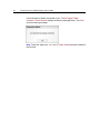
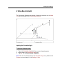
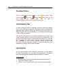
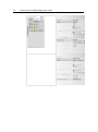
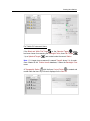
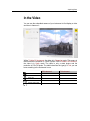
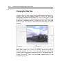
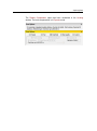
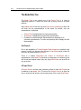
190
Trimble Access for Spatial Imaging User's Guide
Defining a Survey Point Name
A Survey Point is always named "SurveyPointX" where X is its current order.
For a given project, X starts from One and it is incremented from one to one
each time a new Survey Point is added regardless of the station the Survey
Point belongs to.
To Define a Survey Point Name:
1.
2.
3.
4.
5.
Keep the default name: SurveyPoint1.
Or tap in the Point Name field. An on-screen keyboard appears.
Enter a new name in the Point Name field.
Tap Ok. The on-screen keyboard closes by its own.
Tap Next. The Discrete Point Measurement window appears.
Collecting a Survey Point
To Collect a Survey Point:
1.
2.
3.
4.
5.
Move the instrument to an area where you want to collect a Survey Point
(using the scroll-bars).
Tap a point in the Video View.
Tap Measure. At the end of the measurement, Trimble Access displays
the Survey Point as a yellow point with a yellow label and its coordinates
as "HA, VA, SD".
If required, tap another point in the Video View. The previously Survey
Point will be cancelled.
Tap Next.
Tip: A collected Survey Point will not be created in the Trimble Access
database as long as you do not tap the Next button.
Note:
You can swap from "HA, VA, SD" to "X, Y, Z" by tapping "HA, VA, SD"
before (or after measuring) a Survey Point.
The unit of measurement for an angle (HA or VA) is set by default to
Degrees. You can change it in Settings / Units.
The unit of measurement for a distance (SD, X, Y and Z) is set by default
to Meters. You can change it in Settings / Units.